EP3101392B1 - Mapping application with turn-by-turn navigation mode for output to vehicle display - Google Patents
Mapping application with turn-by-turn navigation mode for output to vehicle display Download PDFInfo
- Publication number
- EP3101392B1 EP3101392B1 EP16179680.0A EP16179680A EP3101392B1 EP 3101392 B1 EP3101392 B1 EP 3101392B1 EP 16179680 A EP16179680 A EP 16179680A EP 3101392 B1 EP3101392 B1 EP 3101392B1
- Authority
- EP
- European Patent Office
- Prior art keywords
- user
- vehicle
- destination
- map
- interface
- Prior art date
- Legal status (The legal status is an assumption and is not a legal conclusion. Google has not performed a legal analysis and makes no representation as to the accuracy of the status listed.)
- Active
Links
- 238000013507 mapping Methods 0.000 title description 355
- 238000000034 method Methods 0.000 claims description 105
- 238000012545 processing Methods 0.000 claims description 30
- 230000004044 response Effects 0.000 claims description 4
- 230000006870 function Effects 0.000 description 89
- 230000008569 process Effects 0.000 description 71
- 238000004891 communication Methods 0.000 description 45
- 230000003993 interaction Effects 0.000 description 39
- 230000015654 memory Effects 0.000 description 35
- 238000003860 storage Methods 0.000 description 19
- 238000013459 approach Methods 0.000 description 17
- 230000008859 change Effects 0.000 description 17
- 238000009877 rendering Methods 0.000 description 16
- 230000009471 action Effects 0.000 description 14
- 230000033001 locomotion Effects 0.000 description 13
- 230000007704 transition Effects 0.000 description 11
- 235000015220 hamburgers Nutrition 0.000 description 10
- 239000000872 buffer Substances 0.000 description 9
- 230000002093 peripheral effect Effects 0.000 description 9
- 238000003825 pressing Methods 0.000 description 9
- 230000000875 corresponding effect Effects 0.000 description 8
- 230000003287 optical effect Effects 0.000 description 8
- 238000012552 review Methods 0.000 description 8
- 238000004458 analytical method Methods 0.000 description 7
- 238000012360 testing method Methods 0.000 description 6
- 230000001133 acceleration Effects 0.000 description 4
- 238000004364 calculation method Methods 0.000 description 4
- 230000000694 effects Effects 0.000 description 4
- 238000007667 floating Methods 0.000 description 4
- 230000007246 mechanism Effects 0.000 description 4
- 235000013550 pizza Nutrition 0.000 description 4
- 230000006399 behavior Effects 0.000 description 3
- 238000004590 computer program Methods 0.000 description 3
- 230000001419 dependent effect Effects 0.000 description 3
- 230000002452 interceptive effect Effects 0.000 description 3
- 239000010410 layer Substances 0.000 description 3
- 238000012546 transfer Methods 0.000 description 3
- 238000013519 translation Methods 0.000 description 3
- 230000000007 visual effect Effects 0.000 description 3
- 230000004913 activation Effects 0.000 description 2
- 230000000295 complement effect Effects 0.000 description 2
- 238000010801 machine learning Methods 0.000 description 2
- 239000000203 mixture Substances 0.000 description 2
- 238000003058 natural language processing Methods 0.000 description 2
- 238000004091 panning Methods 0.000 description 2
- 230000002441 reversible effect Effects 0.000 description 2
- 230000035945 sensitivity Effects 0.000 description 2
- 239000007787 solid Substances 0.000 description 2
- 230000003068 static effect Effects 0.000 description 2
- 230000002311 subsequent effect Effects 0.000 description 2
- 241000394635 Acetomicrobium mobile Species 0.000 description 1
- 238000003491 array Methods 0.000 description 1
- 230000008901 benefit Effects 0.000 description 1
- 230000005540 biological transmission Effects 0.000 description 1
- 230000001413 cellular effect Effects 0.000 description 1
- 239000003086 colorant Substances 0.000 description 1
- 238000007906 compression Methods 0.000 description 1
- 230000006835 compression Effects 0.000 description 1
- 238000010276 construction Methods 0.000 description 1
- 239000013068 control sample Substances 0.000 description 1
- 230000003247 decreasing effect Effects 0.000 description 1
- 239000002355 dual-layer Substances 0.000 description 1
- 238000005516 engineering process Methods 0.000 description 1
- 238000005562 fading Methods 0.000 description 1
- 230000008713 feedback mechanism Effects 0.000 description 1
- 238000009472 formulation Methods 0.000 description 1
- 230000014509 gene expression Effects 0.000 description 1
- 238000003306 harvesting Methods 0.000 description 1
- 230000000670 limiting effect Effects 0.000 description 1
- 239000003550 marker Substances 0.000 description 1
- 239000011159 matrix material Substances 0.000 description 1
- 238000010295 mobile communication Methods 0.000 description 1
- 239000003607 modifier Substances 0.000 description 1
- 230000008447 perception Effects 0.000 description 1
- 230000002085 persistent effect Effects 0.000 description 1
- 238000010079 rubber tapping Methods 0.000 description 1
- 238000010845 search algorithm Methods 0.000 description 1
- 239000004065 semiconductor Substances 0.000 description 1
Images


Classifications
-
- G—PHYSICS
- G01—MEASURING; TESTING
- G01C—MEASURING DISTANCES, LEVELS OR BEARINGS; SURVEYING; NAVIGATION; GYROSCOPIC INSTRUMENTS; PHOTOGRAMMETRY OR VIDEOGRAMMETRY
- G01C21/00—Navigation; Navigational instruments not provided for in groups G01C1/00 - G01C19/00
- G01C21/26—Navigation; Navigational instruments not provided for in groups G01C1/00 - G01C19/00 specially adapted for navigation in a road network
- G01C21/34—Route searching; Route guidance
- G01C21/36—Input/output arrangements for on-board computers
- G01C21/3605—Destination input or retrieval
- G01C21/3608—Destination input or retrieval using speech input, e.g. using speech recognition
-
- G—PHYSICS
- G01—MEASURING; TESTING
- G01C—MEASURING DISTANCES, LEVELS OR BEARINGS; SURVEYING; NAVIGATION; GYROSCOPIC INSTRUMENTS; PHOTOGRAMMETRY OR VIDEOGRAMMETRY
- G01C21/00—Navigation; Navigational instruments not provided for in groups G01C1/00 - G01C19/00
- G01C21/26—Navigation; Navigational instruments not provided for in groups G01C1/00 - G01C19/00 specially adapted for navigation in a road network
- G01C21/34—Route searching; Route guidance
- G01C21/36—Input/output arrangements for on-board computers
- G01C21/3605—Destination input or retrieval
- G01C21/3617—Destination input or retrieval using user history, behaviour, conditions or preferences, e.g. predicted or inferred from previous use or current movement
-
- G—PHYSICS
- G01—MEASURING; TESTING
- G01C—MEASURING DISTANCES, LEVELS OR BEARINGS; SURVEYING; NAVIGATION; GYROSCOPIC INSTRUMENTS; PHOTOGRAMMETRY OR VIDEOGRAMMETRY
- G01C21/00—Navigation; Navigational instruments not provided for in groups G01C1/00 - G01C19/00
- G01C21/26—Navigation; Navigational instruments not provided for in groups G01C1/00 - G01C19/00 specially adapted for navigation in a road network
- G01C21/34—Route searching; Route guidance
- G01C21/36—Input/output arrangements for on-board computers
- G01C21/3605—Destination input or retrieval
- G01C21/362—Destination input or retrieval received from an external device or application, e.g. PDA, mobile phone or calendar application
-
- G—PHYSICS
- G01—MEASURING; TESTING
- G01C—MEASURING DISTANCES, LEVELS OR BEARINGS; SURVEYING; NAVIGATION; GYROSCOPIC INSTRUMENTS; PHOTOGRAMMETRY OR VIDEOGRAMMETRY
- G01C21/00—Navigation; Navigational instruments not provided for in groups G01C1/00 - G01C19/00
- G01C21/26—Navigation; Navigational instruments not provided for in groups G01C1/00 - G01C19/00 specially adapted for navigation in a road network
- G01C21/34—Route searching; Route guidance
- G01C21/36—Input/output arrangements for on-board computers
- G01C21/3626—Details of the output of route guidance instructions
- G01C21/3661—Guidance output on an external device, e.g. car radio
-
- G—PHYSICS
- G01—MEASURING; TESTING
- G01C—MEASURING DISTANCES, LEVELS OR BEARINGS; SURVEYING; NAVIGATION; GYROSCOPIC INSTRUMENTS; PHOTOGRAMMETRY OR VIDEOGRAMMETRY
- G01C21/00—Navigation; Navigational instruments not provided for in groups G01C1/00 - G01C19/00
- G01C21/26—Navigation; Navigational instruments not provided for in groups G01C1/00 - G01C19/00 specially adapted for navigation in a road network
- G01C21/34—Route searching; Route guidance
- G01C21/36—Input/output arrangements for on-board computers
- G01C21/3688—Systems comprising multiple parts or multiple output devices (not client-server), e.g. detachable faceplates, key fobs or multiple output screens
-
- G—PHYSICS
- G01—MEASURING; TESTING
- G01C—MEASURING DISTANCES, LEVELS OR BEARINGS; SURVEYING; NAVIGATION; GYROSCOPIC INSTRUMENTS; PHOTOGRAMMETRY OR VIDEOGRAMMETRY
- G01C21/00—Navigation; Navigational instruments not provided for in groups G01C1/00 - G01C19/00
- G01C21/26—Navigation; Navigational instruments not provided for in groups G01C1/00 - G01C19/00 specially adapted for navigation in a road network
- G01C21/34—Route searching; Route guidance
- G01C21/36—Input/output arrangements for on-board computers
Definitions
- mapping application of some embodiments generates different user interfaces for display on the screens of different types of vehicles. Some embodiments generate different user interfaces for each different individual vehicle. On the other hand, some embodiments generate different user interfaces for categories of vehicle screens, such as high-quality touchscreens, low-quality touchscreens, and non-touch screens (with which a user interacts via separate controls built into the vehicle).
- the mapping application of some embodiments when connected to a vehicle, identifies the type of display screen built into the vehicle, and automatically outputs the correct user interface for the vehicle.
- a user of the mapping application may interact with the application via the vehicle interface as well as the mobile device interface (a touchscreen interface in some embodiments). Because of the different capabilities of the different interfaces, as well as the differences in likely user behavior for interactions with the different interfaces, the same operation or type of operation may be implemented differently between the mobile device interface and the vehicle interface. For instance, the mobile device may have the capability to interpret multi-touch gestures (e.g., a pinch gesture to zoom in or out), whereas the vehicle interface may not have multi-touch capability (or any touch capability), and therefore requires different user interaction to zoom (e.g., selection of zoom in and zoom out buttons, either on the touchscreen or the vehicle interface).
- multi-touch gestures e.g., a pinch gesture to zoom in or out
- the vehicle interface may not have multi-touch capability (or any touch capability)
- the vehicle interface output by the mapping application provides additional features in some embodiments.
- the vehicle screen interface for the mapping application is geared towards identifying a destination for a user and entering a navigation mode for a route to that destination, with as little user interaction as possible (because the user is often the driver).
- a user e.g., the driver of the vehicle, a passenger of the vehicle, etc.
- the user may search for a specific address, a specific place name, a generic type of place name, etc.
- the user searches through the vehicle interface via voice interaction (i.e., dictating a search into a microphone of either the mobile device or the vehicle).
- voice interaction i.e., dictating a search into a microphone of either the mobile device or the vehicle.
- the user can scroll through these results in the vehicle interface (through touchscreen interactions, built-in vehicle control interactions, etc.), and choose to enter a navigation mode with a search result as a destination.
- the mapping application of some embodiments offers a predictive routing feature accessible through the vehicle user interface. While driving, the user can select an option to enter the predictive routing mode, in which the mapping application presents various likely routes to the user for navigation.
- the mapping application may generate the likely routes based on a variety of factors, including upcoming appointments or events on a calendar or other scheduling application that runs on the mobile device, analysis of routes taken in the past by the mobile device (e.g., a route from a user's home to work).
- the predictive routing feature may additionally factor in traffic to identify potential difficulties in a usual route or in reaching a location on time.
- the mapping application of some embodiments also offers a recent locations feature that provides a user with recent destinations, results of recent searches, etc. Some embodiments provide search results exclusively from recent searches entered or destinations navigated to through the vehicle interface. On the other hand, some embodiments additionally include search results from recent searches made through the device, even before the connection of the device to the vehicle interface. Thus, if a user searches for a particular destination on her mobile device while walking to her car, then enters the car and connects her device to the car interface, the particular destination will appear as a recent and easily selectable search, without requiring the user to re-enter the search.
- the mapping application enters a turn-by-turn navigation mode in some embodiments.
- some embodiments output different displays to the vehicle display and the mobile device display.
- the vehicle display in some embodiments, displays the user's location and the upcoming route, in either a two dimensional mode or a three dimensional mode.
- the application of some embodiments generates this display from a perspective rendering position within a three dimensional navigation scene, though the view may be shown from directly above the scene so as to render a two dimensional view.
- the user can interact with the vehicle user interface to, e.g., view a list of maneuvers to make for the route (e.g., a right turn onto a particular street), change between two and three dimensions, and other interactions.
- a portion of the vehicle screen displays a representation for the maneuver (e.g., an intersection with an arrow that represents the vehicle's path through the intersection, as well as text directions for the maneuver).
- a representation for the maneuver e.g., an intersection with an arrow that represents the vehicle's path through the intersection, as well as text directions for the maneuver.
- Some embodiments of the invention provide an application that generates multiple user interfaces for display on multiple devices at the same time.
- the application is an integrated mapping and navigation application that runs on a mobile device (e.g., a smart phone, tablet computer, media player, etc.) and generates both (i) a user interface for display on the mobile device and (ii) a user interface for display on a screen of a vehicle to which the mobile device connects.
- the integrated mapping and navigation application (referred to below as a mapping application) generates both user interfaces simultaneously for simultaneous output and display.
- Figure 1 conceptually illustrates such a mapping and navigation application 100 that generates multiple user interfaces simultaneously.
- the mapping and navigation application 100 operates on a mobile device such as a smart phone or tablet device (e.g., an iPhone ® , iPad ® , etc.).
- the mapping and navigation application 100 outputs a first user interface 105 to a local display module 110 of the mobile device and a second user interface 115 to a communication interface 120 with a vehicle.
- the mobile device generating a graphical user interface (or user interface) for the vehicle display screen.
- the graphical display may be sent as a bitmap in some embodiments, a different format that requires translation into a displayed image by the vehicle system, or a combination of bitmaps and different formats.
- This display screen which may be a touchscreen, makes up the vehicle user interface, possibly along with other controls (e.g., joystick, knob, built-in buttons, trackpad, trackball, etc.). These various controls receive inputs and send signals to the mobile device indicating the inputs performed by the user.
- the mapping application on the mobile device (or the operating system, which in some embodiments translates the signals from the vehicle) is configured to recognize these inputs and perform various actions to modify the mapping application graphical display on the vehicle screen, the mobile device screen, or both.
- the interface of some embodiments for a mobile device to communicate with the vehicle in this way is described in further detail in U.S.
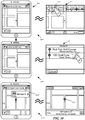
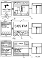
- Figure 2 illustrates an example of a mobile device 200 connected to the interface of a vehicle system.
- a mapping application operates on the mobile device 200, and outputs both a first user interface 205 for the mobile device display screen and a second user interface 210 for the vehicle dashboard display screen 215.
- the figure illustrates the interior of a vehicle 250, in which the mobile device 200 connects via a wired connection to the vehicle, and outputs a user interface for display on a dashboard screen 215 of the vehicle.
- this example, as well as others to follow illustrates a single display screen in the vehicle, some vehicles include multiple screens (e.g., a center dashboard console screen as well as a screen directly in front of the driver).
- Some embodiments output only a single user interface to the center dashboard screen in this case, while other embodiments output the same user interface to multiple screens, and yet other embodiments output different interfaces to the different screens.
- the figure also illustrates a blown-up view of the mobile device 200 and the dashboard screen 215. As shown, both of these display a map of the same location, but within the context of different user interfaces.
- the mobile device interface 205 of some embodiments includes several user interface (UI) controls arranged in a top bar 220 and as floating controls (although other embodiments do not include floating controls and instead include these controls within either the top bar or a second control bar).
- the floating controls of some embodiments include a position control 225 and a 3D control 230, while the top bar 220 includes a direction control 235, a search field 240, and a bookmark control 245.
- the direction control 235 opens a page through which a user can request the mapping application to identify a route (e.g., by accessing a mapping and routing server) between a starting location and an ending location.
- a route e.g., by accessing a mapping and routing server
- the mapping application Upon receiving a selection (e.g., through a tap gesture) of a the direction control 235, the mapping application presents a page allowing the user to select a starting location (e.g., the user's current location or a different location) and an ending location for a route.
- a route has been identified that starts at the current location of the device (e.g., through the direction control 235 or through a different aspect of the UI 205)
- some embodiments enable the user to enter a turn-by-turn navigation mode of the mapping application by selecting a UI control.
- the mapping application presents a view along the selected route, while also providing instructions for upcoming maneuvers to perform (e.g., as road signs with both text and graphical instructions). In some embodiments, the mapping application generates this view from a perspective rendering position within a three dimensional navigation scene that the device renders.
- the user can initiate a search by tapping in the search field 240.
- This directs the application to present an animation that (1) presents an on-screen keyboard and (2) opens a search table with various completions for the user's search entry.
- the search field is empty (e.g., because the user has not yet entered any search terms)
- the table contains a list of "recents", which in some embodiments are recent searches and/or route directions that the user (or a different user of the mapping application on the mobile device 200) has previously requested.
- the recents list may also include addresses searched for or added from other applications on the mobile device (e.g., a web browser), received via various different forms of messaging (e.g., SMS messages, e-mail, etc.), recently accessed contacts, or other mechanisms.
- the mapping application fills the table with search completions both from local sources (e.g., bookmarks, contacts, recent searches, recent route directions, etc.) and remote servers.
- users can activate a voice recognition feature of the mobile device in order to perform searches within the mapping application.
- the position control 225 allows the current position of the device to be specifically noted on the map, as is the case in this figure. Once the position control is selected in some embodiments, the application maintains the current position of the device in the center of the map as the device moves. In some embodiments, the position control can also be used to direct the application to identify the direction to which the device is currently oriented.
- the mapping application of some embodiments identifies the location of the device using coordinates (e.g., longitudinal, latitudinal, and altitudinal coordinates) in a GPS signal that the device receives. Alternatively or conjunctively, the mapping application (or a separate application or operating system of the device) uses other methods (e.g., cell tower triangulation) to compute the current location.
- the 3D control 230 is a control for viewing the map or inspecting a route in three dimensions.
- the mapping application provides the 3D control as a quick mechanism for entering or exiting a 3D mode.
- This control also serves as (1) an indicator that the current map view is a 3D view and (2) an indicator that a 3D perspective is available for a given map view (e.g., a map view that is zoomed out might not have a 3D view available).
- Some embodiments additionally include a page curl control 255 that allows the application to minimize the number of on-screen controls, by placing certain less frequently used actions in a secondary UI page, which is accessible through the "page curl" control displayed on the map.
- the page curl indicates the location of another set of controls that are conceptually located "behind" the map view.
- These controls include selectable controls to drop a pin, show traffic on the map, print a map, or select different map types (e.g., satellite, standard, or a hybrid map type).
- this second UI provides a subset of the functionalities of the first mobile device UI, and is designed to focus the user towards identifying a navigation destination with minimal touch interaction, as the user will often be the driver of the vehicle.
- the vehicle user interface 210 includes, in addition to the map, several UI controls arranged in a top bar 260, and a home button 265 located within a lower information bar 270.
- the vehicle user interface 210 is dependent, in some embodiments, on the type of user interface provided by the vehicle. Some embodiments generate different user interfaces for each different individual vehicle make or model. On the other hand, some embodiments generate different user interfaces for categories of vehicle screens, such as high-quality touchscreens, low-quality touchscreens, and non-touch screens (with which a user interacts via separate controls built into the vehicle).
- the mapping application of some embodiments when connected to a vehicle, identifies the type of display screen built into the vehicle, and automatically outputs the correct user interface for the vehicle. In the case of Figure 2 , the high-quality touchscreen interface of some embodiments is displayed.
- the lower information bar 270 is designed to implement certain features of the mobile device user interface outside of the mapping application. In fact, in some embodiments, the lower information bar 270 is generated by the device operating system for the vehicle display rather than by the mapping application. As shown, the lower information bar 270 includes features also included in an upper information bar 275 of the mobile device user interface, including a clock 280, a battery charge indicator 285, and a connection indicator 290.
- the clock 280 indicates a current time
- the battery charge indicator 285 indicates an amount of battery charge remaining for the mobile device
- the connection indicator 290 indicates a network connection of the mobile device (e.g., LTE, Wi-Fi, etc.).
- the mobile device displays these controls (e.g., above the mapping application interface) without exiting the mapping application.
- the user can then select one of the application controls or dismiss the set of controls by either waiting a short period of time or selecting a location within the mapping application.
- the mobile device 200 displays the same application on both the vehicle display 215 and its own display in most situations. For example, when the device is connected to the vehicle system and the user enters the mapping application via the mobile device, the device 200 also outputs the mapping application UI 210 to the display 215. When a user selects the home button 295 on the mobile device, the UI output to the display screen 215 exits the mapping application as well.
- the search control 261 of some embodiments directs the application towards a search functionality. Unlike the mobile device search control 240, the search functionality accessed through the vehicle interface 210 does not include a typing function. Instead, searching is done through voice recognition.
- search control 261 the application presents an interface that prompts the user to speak into a microphone of either the mobile device or the vehicle.
- the mapping application Based on the search term(s) dictated by the user, the mapping application either (1) presents the user with several selectable options for a search or (2) identifies a requested destination or destinations and presents the destination(s) on the map. For instance, if a user dictates a unique address or business name, the application automatically displays the requested location on the map display.
- the user interface provides two or more options for the user to select.
- the mapping application of some embodiments may present multiple destinations on the map, when several destinations that match the generic request are located nearby.
- the recents control 262 of some embodiments directs the application to present a list of recent destinations, results of recent searches, etc.
- the recents list of some embodiments for the vehicle interface does not provide routes from one location to another, because the vehicle interface is primarily designed for identifying a destination to which to navigate from the current location of the vehicle and device.
- Some embodiments provide search results exclusively from recent searches entered or destinations navigated to through the vehicle interface.
- some embodiments additionally include search results from recent searches made through the device, even before the connection of the device to the vehicle interface.
- the particular destination will appear as a recent and easily selectable search, without requiring the user to re-enter the search through the search control 261.
- the bookmarks control 263 of some embodiments is similar to the bookmarks control 245 of the device interface, in that it enables access to a list of bookmarked locations. Again, as with the recents list, the bookmarks list of some embodiments only provides bookmarked destinations, and does not provide routes. In some embodiments, the bookmarked destinations are those bookmarked on the mapping application running on the mobile device. In other embodiments, the mapping application UI displayed on the vehicle screen includes the ability to add a destination to the bookmarks.
- the predictive routing control 264 enables access to a predictive routing display of the mapping application, in which the mapping application presents various likely routes to the user for navigation.
- the mapping application may generate the likely routes based on a variety of factors, including upcoming appointments or events on a calendar or other scheduling application that runs on the mobile device, or analysis of routes taken in the past by the mobile device (e.g., a route from a user's home to work).
- the predictive routing feature may additionally factor in traffic to identify potential difficulties in a usual route or in reaching a location on time.
- the application presents the likely routes with a navigation view on one portion of the display and information about the route (including estimated arrival time, metadata about the source of the route, etc.) on a second portion of the display, with the ability to scroll through the routes.
- the position control 266 functions similar to the position control 225 of some embodiments, in that its selection will cause the mapping application to center the map view on the current location of the device.
- the position control does not include an additional feature of enabling the user to identify the orientation of the vehicle. Instead, some embodiments automatically orient the map based on the direction of travel of the vehicle, or provide a setting through which the user enables this automatic orientation of the map. Other embodiments automatically orient the map with north facing up irrespective of the vehicle travel direction.
- the map view is centered on the position indicator 269 that indicates the current location of the device.
- Some embodiments disable the position control when the map view is centered on the position indicator.
- the position control 266 is displayed in grayed-out fashion, to indicate its current disabled state.
- Figure 9 below illustrates the enabling of the position control as the user moves the map region so that the position control is no longer centered.
- the mapping application enters a turn-by-turn navigation mode in some embodiments. In this mode, some embodiments output different displays to the vehicle display and the mobile device display.
- the vehicle display in some embodiments, displays the user's location and the upcoming route, in either a two dimensional mode or a three dimensional mode.
- the mapping application generates this view from a perspective rendering position within a three dimensional navigation scene that the device renders.
- This perspective rendering position is adjustable in some embodiments and can be viewed as a virtual camera that can capture the three dimensional navigation scene from a variety of different perspectives (e.g., from a variety of different positions and orientations).
- the turn-by-turn navigation presents an animated rendering of a navigated route rendered from the vantage point of a virtual camera that traverses along the direction of the route based on the traversal direction and speed of the vehicle to which the device is connected.
- this direction and speed is captured by data (e.g., GPS data, triangulated cell tower data, etc.) associated with the device.
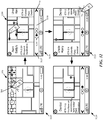
- Figure 3 conceptually illustrates a simplified software architecture for a mapping and navigation application 300 of some embodiments.
- the application 300 operates on a mobile device that can be connected to a vehicle.
- the vehicle connection requires a wired connection that additionally enables charging of the electronic device (e.g., a USB connection).
- the mobile device can connect wirelessly to the vehicle display interface.
- the mapping application 300 includes various mapping and navigation functions 305, a local device user interface generator 310, a high-quality vehicle touchscreen user interface generator 315, a low-quality vehicle touchscreen user interface generator 320, a non-touch vehicle touchscreen user interface generator 325, and a vehicle user interface selector 340 that uses a vehicle display lookup table 345.
- Figure 3 also displays a local display module 330 and a communication interface 335 for connecting to a vehicle electronic system.
- the local display module 330 and the communication interface 335 are also part of the mobile device on which the mapping application 300 operates, though not part of the mapping application 300 itself.
- the mapping and navigation functions 305 perform a wide variety of mapping and/or navigation processes for the mapping application. These functions may include identifying map tiles from which to generate map displays and retrieving the map tiles from a remote server, matching a device location to a location on a map, storing and retrieving bookmarked or recent search results, retrieving route information from a server, generating predicted routes based on analyzing data travel history, data from other applications, etc., generating text and/or graphical navigation instructions for a route based on the retrieved route information, and other functions.
- the local display module 330 of some embodiments handles display of the mobile device user interface of the mapping application.
- the mobile device display is a touchscreen which, in addition to displaying a user interface, accepts touchscreen interactions.
- Either the local display module 330 or a separate touchscreen interaction reader receives these touchscreen interactions and translates the interactions into multi-touch gestures (e.g., one-finger tap, one-finger double tap, one-finger swipe, two-finger swipe, etc.) at particular locations (e.g., coordinates) of the touchscreen.
- multi-touch gestures e.g., one-finger tap, one-finger double tap, one-finger swipe, two-finger swipe, etc.
- These gestures are sent from the operating system to the mapping application 300 (e.g., to the local device user interface generator 310 or a separate module that translates the gesture and location into an interaction with the displayed mapping application constructs.
- the high-quality vehicle touchscreen user interface generator 315, the low-quality vehicle touchscreen user interface generator 320, and the non-touchscreen vehicle user interface generator 325 generate three different user interfaces for display on the screens of different vehicles (e.g., screens located in the dashboards of the vehicles).
- the mapping application 300 of some embodiments generates a first user interface for high-quality touchscreens, a second user interface for low-quality touchscreens, and a third user interface for non-touchscreen displays.
- Each of the vehicle UI generators 315-325 sends their UIs to the communication interface 335 that connects to the vehicle system. While the figure shows all three modules communicating with the interface, in some embodiments only one of the UIs will be generated at a given time, depending on the vehicle to which the device is connected.
- this communication interface is a Universal Serial Bus (USB) interface through which the device communicates with the vehicle system, as well as through which the device is charged.
- the communication interface may be one of several different interfaces (e.g., USB, Bluetooth, etc.) depending on how the user chooses to connect the device to the vehicle system.
- the mapping application 300 also receives interactions with the vehicle system (i.e., touchscreen and/or non-touchscreen interactions) to control the mapping and navigation functions through the communication interface 335.
- the vehicle system identifies the location and type of touchscreen gestures (e.g., single or double tap centered at a particular set of coordinates) and sends this information to the mapping application 300 for its interpretation with respect to the displayed user interface.
- the vehicle system sends the raw touchscreen data (e.g., pressure data) to the mobile device for translation into gestures at particular locations.
- the interactions received through the vehicle interface may also include non-touchscreen interactions, such as the pushing of specific buttons, joystick motion, etc.
- the vehicle user interface selector 340 identifies which of the three types of vehicle user interfaces should be generated and communicates this information to both the mapping and navigation functions 305 and the different user interface generators 315-325.
- the vehicle user interface selector 340 is part of the operating system of the mobile device rather than part of the mapping application.
- the vehicle user interface selector 340 receives information about the vehicle display screen through the communication interface 335 (e.g., through a specific communication channel of the interface). This information, in some embodiments, includes one or more characteristics of the vehicle display screen.
- the vehicle user interface selector 340 uses the vehicle display lookup table 345 to select one of the three types, or categories, of interfaces for the mapping application to generate.
- the mapping application generates numerous different interfaces that cater to the specifics of the vehicle displays with greater granularity. For instance, some embodiments generate multi-touch capable vehicle user interfaces, interfaces for vehicles that include both touchscreen and knob-type inputs, etc.
- the vehicle system identifies properties of its display device (e.g., touch latency, touch resolution, display resolution, additional inputs (e.g., knobs, etc.). Based on the identified properties, the mapping application (or the device operating system) identifies a type of user interface (e.g., high-quality touch, low-quality touch, non-touch) to generate from a stored matrix or lookup table.
- properties of its display device e.g., touch latency, touch resolution, display resolution, additional inputs (e.g., knobs, etc.).
- the mapping application or the device operating system identifies a type of user interface (e.g., high-quality touch, low-quality touch, non-touch) to generate from a stored matrix or lookup table.
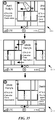
- the second example 510 of Figure 5 illustrates such an interface output to a second vehicle by the mapping application.
- This second example illustrates two stages 530 and 535 of a low-quality touchscreen vehicle display.
- the first stage 530 illustrates the same home page user interface 550 as the high-quality touchscreen example 505, output by the mobile device operating system when the mobile device is connected to a vehicle system with a low-quality touchscreen interface.
- Some embodiments include the same home page for the vehicle UI irrespective of the quality of the touchscreen.
- the controls for this home page are described above by reference to the first example 505.
- the user selects the map control 563 with a touch selection.
- the second stage 535 illustrates the resultant mapping application user interface 570 for low-quality touchscreens.
- the vehicle interface when the vehicle interface does not have a touchscreen (i.e., does not have a low-quality or high-quality touchscreen), then the vehicle interface will have a non-touch display screen. As such, the process generates and outputs (at 435) a non-touchscreen vehicle user interface. The process then ends.
- the third example 515 of Figure 5 illustrates such an interface output to a third vehicle by the mapping application.
- This third example illustrates two stages 540 and 545 of the non-touchscreen vehicle display.
- the first stage 540 illustrates a home menu user interface 575 displayed on the vehicle screen, as well as vehicle hardware controls 580. While this figure illustrates the vehicle hardware controls 580 located directly below the display screen, different vehicles may have their controls located in different places. For instance, some embodiments include controls in the center console between the driver and passenger seats, on the steering wheel, etc.
- the vehicle hardware controls 580 include a keypad 591, a joystick 592, as well as several additional buttons located above and below the joystick. These additional buttons enable the user to access various functions of the vehicle system (e.g., music, phone calls with a connected phone), as well as navigate a set of menus provided by the vehicle system (e.g., to access an in-car navigation system provided with the vehicle).
- the mobile device operating system and/or mapping application leverage these buttons as well as the joystick for interactions with the user interface provided by the mobile device.
- the non-touch user interface home menu 575 output by the mobile device illustrates the same options as in the touchscreen user interface 550, but arranged differently.
- the vehicle display initially displays only the clock, and the user accesses the home menu UI 575 by selecting a menu button 593.
- the home menu 575 includes a phone option, music option, map option, messaging option, car option, and now playing option, which correspond to the controls 560-567 of the touchscreen UI 550.
- the user can use the joystick 592 (or a trackball, arrow buttons, turnable knob, etc.) to scroll between the different menu options.
- the first stage 540 illustrates that, with the map menu option 594 selected, the user performs a selection input by pressing downwards on the joystick 592. This selects the mapping application, and causes the display of the mapping application non-touch user interface 595 at the second stage 545. Because the display screen is a non-touch screen, the user interface does not display any controls, and only has the map view and the lower information bar. The lower information bar, unlike those for the touchscreen UIs 565 and 570, does not include a home button. Instead, in some embodiments, the user can select a hardware control (e.g., the back or exit button) to perform the function of the home button.
- a hardware control e.g., the back or exit button
- the predictive routing UI 755 of some embodiments displays, for each route, a first panel 760 with information about the route and a second panel 765 with a map view of the route.
- the information panel 760 displays a name for the route as well as metadata about the route.
- the route name may be based on a destination name identified from contact information, a calendar appointment name, a business name, an address, a primary road used by the route, etc.
- the metadata shown may include an estimated arrival time (ETA), the source of the route for the predictive routing engine (e.g., calendar, passbook, travel history, etc.), whether the destination of the route is a frequent or less traveled destination for the device, and other information.
- ETA estimated arrival time
- FIG. 8 illustrates the use of the search function to identify a destination and then enter a navigation mode over six stages 805-830.
- the first stage 805 illustrates the user interface 565 as shown in Figure 5 .
- a user selects the search control 571.
- Figure 9 illustrates various user interface actions available in some embodiments to enable such exploration of the map region. Specifically, over six stages 905-930 of the user interface 565, Figure 9 illustrates the user of zoom and scroll functionality as well as the position control 576 to re-center the displayed map region on the device's current location.
- the map changes zoom levels by an amount proportional to the duration for which the user holds the touchscreen input over the zoom in or out control, while using an inertial stop animation after the user releases the press-and-hold input.
- Some such embodiments differentiate between a tap input and a press-and-hold input, so that a tap input causes the application to change the zoom level of the map a greater amount than would be the case for a press-and-hold having the short duration of the tap gesture.
- the mapping application zooms the map region about the center of the display, which also coincides with the position indicator 860. Some embodiments always center the zoom about the center of the map, while other embodiments always center the zoom about the current location of the device. In some embodiments, the mapping application centers the zoom about the current location when the position indicator is within the displayed map region and about the center of the displayed map when the position indicator is not within the displayed map region.
- the sixth stage 930 illustrates the UI 565 after the user has not interacted with the display, but has driven a short distance along the current road.
- the clock has rolled forward to 2:15, and the map display has shifted downwards so that the device's current location remains in the center.
- the mapping application only automatically moves the map region along with the current location when the map view is already centered on the position indicator 860 (i.e., when the user has selected the position control 576 without subsequently scrolling the map via a swipe gesture).
- Figure 10 illustrates a user exploring a map in both the mapping application interface 205 displayed on a mobile device 1000 as well as the high-quality vehicle touchscreen interface 565 displayed on the screen of a vehicle to which the mobile device 1000 connects over three stages 1005-1015.
- the mapping application is open in both the mobile device and the touchscreen.
- the map region currently displays a region surrounding the current location of the device, with the current location centered and tracked.
- the user performs a leftward swipe gesture over the map region in the high-quality vehicle touchscreen user interface 565 in order to pan the map to the right.
- the second stage 1010 illustrates that the map displayed in the vehicle screen is no longer centered on the current location of the device, with a different portion of the map region displayed instead. However, the map region displayed on the mobile device 1000 has not changed.
- the user performs a pinch multi-touch gesture over the map region displayed on the mobile device in order to zoom in on the map region.
- the third stage 1015 illustrates that the mobile device user interface 205 displays the map region at a closer zoom level, while the vehicle user interface 565 does not change from the second to the third stage.
- the bookmarks and recents lists only require gestural input for scrolling through a list of possible choices, when the list is too numerous to fit entirely on the screen. Some embodiments therefore place scroll arrows next to the list for non-gestural (e.g., tap) selection.
- the search feature does not involve any gestural input (except in rare instances when the search term is ambiguous, with numerous possibilities that require scrolling) or high touch sensitivity resolution and therefore this feature is the same for the low-quality touchscreen interface as the high-quality touchscreen interface.
- the first stage 1105 also illustrates that the user selects the zoom and scroll control 587, with a tap selection input. As shown at the second stage 1110, this input results in the display of additional controls within the map view user interface 570. These additional controls include four scroll arrow controls 1140-1155, position control 586, and zoom controls 1160 and 1165.
- the position control 586 is the same position control as in the first stage 1105, but has been relocated to a different position within the top control bar. As before, the position control 586 enables the user to cause the mapping application to re-center the map view on the device's current location.
- the zoom controls 1160 and 1165 have the same function as zoom controls 577 and 578 of the high-quality touchscreen interface 565. That is, the control 577 causes the mapping application to zoom in on the map region while the control 578 causes the mapping application to zoom out of the map region.
- the scroll arrows 1140-1155 enable the user to scroll through the map region incrementally in some embodiments.
- the displayed map region moves in the direction opposite the arrow in order to reveal a region of the map in the direction of the arrow.
- the third stage 1115 illustrates a user selecting the left scroll arrow control 1155.
- the user may select the scroll arrows 1140-1155 with a tap input in some embodiments, or a press and hold input in other embodiments.
- the process 1300 begins by displaying (at 1305) scroll controls for the low-quality touchscreen interface. This occurs when the mapping application receives input to select the zoom and scroll control of the low-quality touchscreen interface.
- the first stage 1405 of Figure 14 illustrates a low-quality touchscreen interface 1400.
- a user selects the zoom and scroll control 1420.
- the second stage 1410 illustrates the zoom and scroll controls, including scroll arrows 1425-1440.
- the process 1300 receives (at 1310) a selection of a location on the vehicle touchscreen within the map view. That is, the selection is not a selection of the zoom controls, position indicator, done button, etc., but rather is within the map where the mapping application displays the scroll controls.
- the second stage 1410 of Figure 14 illustrates that the user makes a selection at a specific touchscreen location between the up arrow 1425 and the right arrow 1430.
- the process 1400 then calculates (at 1315) the angle of a line from the center of the scroll controls to the center of the touch input.
- the center of the scroll controls does not exactly coincide with the center of the vehicle display screen because the top bar with the zoom and position controls takes up a portion of the display.
- the vehicle touchscreen system translates its touch input into a selection at a particular location, which the vehicle system sends to the mobile device (via the mobile device's connection to the vehicle system). Using this information, the mapping application can calculate the angle.
- the second stage of Figure 14 illustrates that in this example, the angle between the user's selection location and the horizontal is again ⁇ .
- the process determines (at 1320) whether the angle is within a threshold of one of the primary scroll directions.
- This threshold in some embodiments, is a particular angular range (e.g., 5°, 10°, etc.) from the horizontal or vertical. In some embodiments, the range is defined based on the display of the scroll arrows: if the selection input is within the minimum range that includes the entirety of the displayed scroll control, then the selection is within a threshold of that primary scroll direction.
- the process scrolls (at 1330) the map according to the selection of the closest primary direction scroll control. Thus, if the selection is near the right arrow 1430, the map will shift leftwards to display the portion previously off the screen to the right.
- bookmarks and recents lists may include scroll arrows for scrolling through a list of bookmarks or recents (e.g., recent searches, destinations, etc.).
- Figure 16 illustrates the use of scroll arrows to navigate through a list of recents over four stages 1605-1620 of the low-quality touchscreen interface of some embodiments.
- the first stage 1605 illustrates the low-quality vehicle touchscreen mapping application interface 570.
- the user selects the recents control 582 in order to open a recents list.
- Figure 19 illustrates the search feature in the case of an ambiguous search term over five stages 1905-1925 of the high-quality touchscreen user interface.
- the search feature in some embodiments, operates the same in both the high-quality and low-quality touchscreen interfaces, and similarly in the non-touchscreen interface, with differences that will be explained in detail below.
- the application automatically transition to the search results map view page 852, with the search term "Coffee” appearing in the upper information bar 865.
- This search term produces six search results within the region searched (e.g., within a particular distance of the device, or drivable within a particular duration from the location of the device).
- the map region displays a map with a pin for each of the six search results, and one of these pins displayed as selected.
- Some embodiments automatically initially select the search result closest to the device's current location. In some embodiments, other factors may affect the ordering (i.e., ranking) of the search results returned by a search engine (e.g., a search server).
- the user selects (via a tap input) the right arrow control 2150.
- the seventh stage 2135 illustrates that the mapping application has selected the second closest result to the user's location, Killer Coffee, and shifted the map region so that the pin 2160 for this location is now in the displayed portion of the map region.
- some embodiments center each particular pin upon stepping through the search results to the particular pin and selecting the particular pin.
- Other embodiments modify the map display so that the pin is within a particular threshold of the center and the center of the displayed map region is equidistant from the selected pin and the current location.
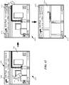
- Figure 7 above illustrated that when the user selects the recents control in a touchscreen interface (or selects the recents menu option in a non-touchscreen interface), the mapping application displays in that interface a list of destinations recently searched in the mapping application.
- these recent destinations may include destinations that have appeared as search results in the mapping application when searched through the mobile device interface of the mapping application.
- the user selects the destination 123 Opal Cove from the recents list.
- the third stage 2915 illustrates the result of this selection in both of the mapping application interfaces.
- the mapping application displays a pin at the selected address as well as an expandable banner 2920 for the result.
- This banner 2920 includes a selectable item 2925 that enables the user to command the application to enter turn-by-turn navigation with 123 Opal Cove as the destination.
- the mapping application displays the search results map view with a pin 2930 for 123 Opal Cove as a selected destination. In this case, the application displays the selected destination in the center of the map view in both UIs.
- Figure 30 illustrates the corresponding action taken within the vehicle user interface 565 over three stages 3005-3015.
- the first stage 3005 displays the same mobile device UI 205 and vehicle user interface 565 for the mapping application as in the first stage of Figure 29 .
- the user selects the recents control 572 in the vehicle user interface 565.
- the mapping application outputs the recent destinations page 735 to the vehicle display.
- the mobile device interface displayed both a location (123 Opal Cove) and a route (Cool Coffee Shop to Putt-Putt Golf Course)
- the vehicle user interface recent destinations page 735 only displays locations (i.e., possible destinations for navigation).
- the mapping application of some embodiments uses a predictive routing engine, which may be a part of the mapping application or operating separately from the mapping application on the mobile device.
- the predictive routing engine can (1) formulate predictions about current or future destinations and/or routes to such destinations and (2) relay information to the user of the device about the predictions.
- the predictive routing engine includes a machine-learning engine that facilitates the formulation of predicted future destinations and/or routes based on stored, user-specific data.
- the second stage 3110 illustrates the predictive routing user interface 755 of some embodiments.
- the predictive routing UI 755 displays, in order of likelihood as computed by the predictive routing engine, one or more likely destinations and routes to those destinations. As described above by reference to Figure 7 , the predictive routing UI 755 displays, for each predicted destination, a first panel 760 with information about the destination and a second panel 765 with a map view of a route to the destination.
- the information panel 760 displays a name for a current destination/route as well as metadata about the destination or route.
- This name may be based on a destination name identified from contact information, a calendar appointment name, a business name, an address, a primary road used by the route, etc.
- the displayed metadata may include an estimated arrival time, the source of the route for the predictive routing engine (i.e., how the predictive routing engine determined the destination as a likely end point for the current trip), whether the destination is a frequent or less traveled destination for the device (and therefore the user of the device), etc.
- the user again performs a leftward swipe gesture. As shown at the fourth stage 3120, this again causes the application to slide the information for the second destination to the left and indicate a third predicted destination.
- This third destination has a name of Dentist, an ETA of 2:43, and is a rare destination for the user.
- the metadata indicates that the user has an appointment at the dentist today. As an example, the user might have scheduled a dentist appointment for 4:00, and also added a calendar event to see her uncle at 3:00.
- the third of the circles 3135 is now filled in.
- the different predicted destinations and associated routes are arranged in a filmstrip view.
- the application animates the sliding of the conceptual filmstrip through the display screen.
- Figure 35 illustrates this animation over three stages 3505-3515.
- the first stage 3505 is the same as the second stage 3110 of Figure 31
- the third stage 3505 is the same as the third stage 3115 of that figure (without the additional swipe gesture shown in the third stage 3115 of Figure 31 ).
- the second stage 3510 illustrates the animation of some embodiments to transition between these stages. Specifically, at this stage, the information panel and part of the map view for the first predicted route has slid off of the display, while the entirety of the information panel and part of the map view for the second predicted route has slid onto the display.
- a different arrangement and animation of the predicted routes is used. Rather than arranging the displays for the predicted routes one after another in a filmstrip, some embodiments conceptually treat the displays for different routes as cards stacked on top of each other.
- Figure 36 illustrates the animation between two predicted route displays for this type of arrangement.
- the application does not display a portion of the information for the second predicted route while showing the view for the first route. While this is shown for the stacked-card arrangement, one of ordinary skill will recognize that some embodiments that use the filmstrip arrangement will also not display any portion of the information panel for the next predicted route.
- the user performs a swipe gesture to cause the application to display the second predicted route.
- Figure 37 illustrates this feature of the predictive routing interface of some embodiments for entering the turn-by-turn navigation mode of the mapping application over two stages 3705-3710.
- the first stage 3705 illustrates the predictive routing interface 755 of some embodiments, as shown in the previous figures.
- a user performs a tap gesture over the map view panel 765 with Aunt Sally's as the currently displayed destination.
- the mapping application has entered its turn-by-turn navigation mode for a route heading to Aunt Sally's.
- the application displays a specific selectable option for entering turn-by-turn navigation, and a tap gesture over the display instead returns the display to the map exploration user interface.
- the turn-by-turn navigation mode of some embodiments will be described in further detail in the following Section VI.
- the mapping application vehicle user interface of some embodiments is designed for the user to quickly and easily identify a destination for entering turn-by-turn navigation.
- the mapping application outputs different views for navigation to the two different interfaces. Specifically, the mapping application outputs a map view from above and/or behind the vehicle to the vehicle display screen, while outputting only navigation instructions to the mobile device display screen.
- the application of some embodiments slides a navigation instruction panel into the navigation user interface 885 in order to alert the driver of the upcoming maneuver to perform.
- the third stage 4015 illustrates that as the vehicle approaches the intersection where the route turns right, a navigation instruction panel 4035 begins to slide onto the display, as represented by the right-facing arrows (which are not actually displayed within the user interface).
- the mapping application of some embodiments animates the introduction of this panel once the vehicle approaches within a threshold distance (e.g., 250 ft., 200 ft., 100 m, etc.) of the intersection at which the maneuver will be performed.
- the navigation instruction panels always appear on the driver side of the display. Therefore, in countries such as the United States, that drive on the right side of the road (with the driver seat on the left side of the car), the application places the panel on the left side of the display. On the other hand, in countries such as the United Kingdom that drive on the left side of the road (with the driver seat on the right side of the car), the application places the navigation instruction panel on the right side of the display.
- the sixth stage 4030 illustrates the navigation UI 885 after the application has completed the removal of the instruction panel from the display.
- the navigation information bar 4050 has returned, and displays a summary of the new next maneuver.
- the navigation map view will follow along behind the indicator of the device location 4040 until the next intersection is approached, or the user selects one of the controls in the user interface (e.g., the 3D control or the list control).
- the third stage 4115 illustrates the display after the animation to display the direction list 4125 has fully completed.
- the direction list begins with a starting location (1018 Chico Ave ).
- a name for the location is available (e.g., based on contact information indicating a particular person's house, map data indicating a place of business, etc.,) some embodiments additionally display this name as part of the starting address.
- the application displays a pin to indicate that the entry in the direction list is a location, rather than a maneuver.
- the second stage 4210 illustrates that this action causes the application to modify the navigation information bar 4050.
- the upper portion of the vehicle display now includes an end navigation control 4220 and an overview control 4225.
- the end navigation control 4220 allows the user to end the current turn-by-turn navigation mode and return to the map exploration interface.
- the overview control 4220 allows the user to view an overview of the route being navigated.
- the route and maneuver information in the navigation information bar is compressed to fit within a smaller area.
- This bar continues to display the same route summary information (arrival time, remaining distance, remaining time), and also displays the graphical representation and distance to the next maneuver in the same manner.
- the text instructions however, use a shorter version in order to fit within the smaller area. Some embodiments remove the text instructions altogether.
- This figure illustrate turn-by-turn navigation within the touchscreen user interfaces of some embodiments.
- the non-touchscreen interfaces also have the capability to enter turn-by-turn navigation mode.
- Some embodiments limit the functionality for non-touchscreen displays (e.g., always displaying in either 2D or 3D with no control to switch back and forth, not having a direction list control, etc.), while other embodiments use various types of inputs from the built-in vehicle controls to toggle between 2D and 3D presentations or to cause the application to animate the direction list onto or off of the display.
- Some embodiments in fact, modify the mobile device interface during navigation (described below) to include the 3D control and direction list control. Selection of these controls on the mobile device then affects the non-touchscreen vehicle interface.
- the first stage 4605 illustrates that the mapping application is open on a mobile device 4600 while connected to a vehicle display.
- the vehicle touchscreen displays the high-quality touchscreen map exploration interface 565, while the user has previously selected a search field of the mobile device map interface to cause the application to display a list of recent routes and locations. The user selects a route from the device's current location to Putt-Putt Golf Course from this recents list.
- the mobile device 4800 has already entered power-saving mode.
- the displayed words "Power Save Mode” do not actually appear on the device's display, but are shown here for explanatory purposes.
- the device may enter power save mode when the user has not interacted with the device for a particular period of time, or because a user has pressed a particular hardware button or touchscreen control to do so (e.g., button 4820 of the mobile device 4800).
- the application displays the navigation map view 885 on the vehicle display screen.
- the mobile device still performs the various navigation operations, including rendering the animated 3D map view, required to output the display to the vehicle.
- Figure 49 illustrates the home pages of the mobile device and vehicle displays of some embodiments while turn-by-turn navigation mode is operational and the vehicle approaches a maneuver. This figure illustrates, for each of three stages 4905-4915, both of the displayed interfaces as well as a map 4900 that indicates the location of the vehicle and mobile device at the stage.
- the banner 4936 is not displayed in the home page of the vehicle screen. Instead, the return to navigation banner is displayed as part of the operating system information bar that includes the simulated home button, which is not shown in the vehicle screen home page of some embodiments.
- Figure 50 illustrates the display outside the mapping application with turn-by-turn navigation operating according to some embodiments, over three stages 5005-5015.
- the first stage 5005 is the same as the first stage 4905 of Figure 49 , with the user selecting a home button 5025 on the mobile device 5020.
- Computer readable storage medium also referred to as computer readable medium.
- these instructions are executed by one or more computational or processing unit(s) (e.g., one or more processors, cores of processors, or other processing units), they cause the processing unit(s) to perform the actions indicated in the instructions.
- computational or processing unit(s) e.g., one or more processors, cores of processors, or other processing units
- Examples of computer readable media include, but are not limited to, CD-ROMs, flash drives, random access memory (RAM) chips, hard drives, erasable programmable read-only memories (EPROMs), electrically erasable programmable read-only memories (EEPROMs), etc.
- the computer readable media does not include carrier waves and electronic signals passing wirelessly or over wired connections.
- the system memory 5320 is a read-and-write memory device. However, unlike storage device 5335, the system memory 5320 is a volatile read-and-write memory, such a random access memory.
- the system memory 5320 stores some of the instructions and data that the processor needs at runtime.
- the invention's processes are stored in the system memory 5320, the permanent storage device 5335, and/or the read-only memory 5330.
- the various memory units include instructions for processing multimedia clips in accordance with some embodiments. From these various memory units, the processing unit(s) 5310 retrieves instructions to execute and data to process in order to execute the processes of some embodiments.
- bus 5305 also couples the vehicle electronic system 5300 to one or more communication subsystems 5325 through which the vehicle system can communicate with a mobile device, such as that shown above in Figure 52 .
- These communication subsystems may include both wireless (e.g., Bluetooth ® , Wi-Fi, etc.) communication subsystems and wired (e.g., USB, Firewire ® , etc.) communication subsystems. Any or all components of the vehicle electronic system 5300 may be used in conjunction with the invention.
- ASICs application specific integrated circuits
- FPGAs field programmable gate arrays
- PLDs programmable logic devices
- ROM read only memory
- RAM random access memory
- map services generate map service data relying upon various data formats separate from a map tile in some embodiments.
- map services that provide location data may utilize data formats conforming to location service protocols, such as, but not limited to, Radio Resource Location services Protocol (RRLP), TIA 801 for Code Division Multiple Access (CDMA), Radio Resource Control (RRC) position protocol, or LTE Positioning Protocol (LPP).
- RRLP Radio Resource Location services Protocol
- CDMA Code Division Multiple Access
- RRC Radio Resource Control
- LTP LTE Positioning Protocol
- Embodiments may also receive or request data from client devices identifying device capabilities or attributes (e.g., hardware specifications or operating system version) or communication capabilities (e.g., device communication bandwidth as determined by wireless signal strength or wire or wireless network type).
- a map service may obtain map service data from internal or external sources.
- satellite imagery used in map image data may be obtained from external services, or internal systems, storage devices, or nodes.
- Other examples may include, but are not limited to, GPS assistance servers, wireless network coverage databases, business or personal directories, weather data, government information (e.g., construction updates or road name changes), or traffic reports.
- Some embodiments of a map service may update map service data (e.g., wireless network coverage) for analyzing future requests from client devices.
- client devices communicate utilizing various data formats separate from a map tile.
- client devices implement Assisted Global Positioning Satellites (A-GPS) and communicate with location services that utilize data formats conforming to location service protocols, such as, but not limited to, Radio Resource Location services Protocol (RRLP), TIA 801 for Code Division Multiple Access (CDMA), Radio Resource Control (RRC) position protocol, or LTE Positioning Protocol (LPP).
- RRLP Radio Resource Location services Protocol
- CDMA Code Division Multiple Access
- RRC Radio Resource Control
- LTE Positioning Protocol LTE Positioning Protocol
- Client devices may also receive GPS signals directly.
- Embodiments may also send data, with or without solicitation from a map service, identifying the client device's capabilities or attributes (e.g., hardware specifications or operating system version) or communication capabilities (e.g., device communication bandwidth as determined by wireless signal strength or wire or wireless network type).
- devices 5402b and 5402c can place and receive phone calls, send and receive e-mail messages, and retrieve electronic documents over access device 5412 and WAN 5420.
- any of the illustrated client device may communicate with map service 5430 and/or other service(s) 5450 using a persistent connection established in accordance with one or more security protocols, such as the Secure Sockets Layer (SSL) protocol or the Transport Layer Security (TLS) protocol.
- SSL Secure Sockets Layer
- TLS Transport Layer Security
- Devices 5402a, 5402b, and 5402c can communicate with map service 5430 over the one or more wire and/or wireless networks, 5410 or 5412.
- map service 5430 can provide a map service data to rendering devices 5402a, 5402b, and 5402c.
- Map service 5430 may also communicate with other services 5450 to obtain data to implement map services.
- Map service 5430 and other services 5450 may also receive GPS signals from GPS satellites 5460.
- these parameters may affect the composition of the search results (and/or the ordering of the search results) based on different priority weightings.
- the search results that are returned may be a subset of results selected based on specific criteria include but not limited to a quantity of times the search result (e.g., a particular point of interest) has been requested, a measure of quality associated with the search result (e.g., highest user or editorial review rating), and/or the volume of reviews for the search results (e.g., the number of times the search result has been review or rated).
Landscapes
- Engineering & Computer Science (AREA)
- Remote Sensing (AREA)
- Radar, Positioning & Navigation (AREA)
- Automation & Control Theory (AREA)
- Physics & Mathematics (AREA)
- General Physics & Mathematics (AREA)
- General Health & Medical Sciences (AREA)
- Health & Medical Sciences (AREA)
- Human Computer Interaction (AREA)
- Audiology, Speech & Language Pathology (AREA)
- Artificial Intelligence (AREA)
- Acoustics & Sound (AREA)
- Social Psychology (AREA)
- Navigation (AREA)
- User Interface Of Digital Computer (AREA)
Applications Claiming Priority (7)
| Application Number | Priority Date | Filing Date | Title |
|---|---|---|---|
| US201361800908P | 2013-03-15 | 2013-03-15 | |
| US201361832818P | 2013-06-08 | 2013-06-08 | |
| US201361832853P | 2013-06-08 | 2013-06-08 | |
| US201361832928P | 2013-06-09 | 2013-06-09 | |
| US201361875753P | 2013-09-10 | 2013-09-10 | |
| US14/081,915 US9857193B2 (en) | 2013-06-08 | 2013-11-15 | Mapping application with turn-by-turn navigation mode for output to vehicle display |
| EP14158182.7A EP2778614B1 (en) | 2013-03-15 | 2014-03-06 | Mapping application with turn-by-turn navigation mode for output to vehicle display |
Related Parent Applications (1)
| Application Number | Title | Priority Date | Filing Date |
|---|---|---|---|
| EP14158182.7A Division EP2778614B1 (en) | 2013-03-15 | 2014-03-06 | Mapping application with turn-by-turn navigation mode for output to vehicle display |
Publications (2)
| Publication Number | Publication Date |
|---|---|
| EP3101392A1 EP3101392A1 (en) | 2016-12-07 |
| EP3101392B1 true EP3101392B1 (en) | 2021-12-15 |
Family
ID=52707448
Family Applications (4)
| Application Number | Title | Priority Date | Filing Date |
|---|---|---|---|
| EP16179680.0A Active EP3101392B1 (en) | 2013-03-15 | 2014-03-06 | Mapping application with turn-by-turn navigation mode for output to vehicle display |
| EP14725931.1A Ceased EP2946172A1 (en) | 2013-03-15 | 2014-03-12 | User interface for displaying predicted destinations |
| EP14722422.4A Active EP2946171B1 (en) | 2013-03-15 | 2014-03-12 | Mapping application search function |
| EP21174530.2A Pending EP3889546A1 (en) | 2013-03-15 | 2014-03-12 | Mapping application search function |
Family Applications After (3)
| Application Number | Title | Priority Date | Filing Date |
|---|---|---|---|
| EP14725931.1A Ceased EP2946172A1 (en) | 2013-03-15 | 2014-03-12 | User interface for displaying predicted destinations |
| EP14722422.4A Active EP2946171B1 (en) | 2013-03-15 | 2014-03-12 | Mapping application search function |
| EP21174530.2A Pending EP3889546A1 (en) | 2013-03-15 | 2014-03-12 | Mapping application search function |
Country Status (5)
| Country | Link |
|---|---|
| EP (4) | EP3101392B1 (zh) |
| CN (8) | CN105051496B (zh) |
| AU (5) | AU2014235245B2 (zh) |
| TW (2) | TWI572849B (zh) |
| WO (2) | WO2014151155A1 (zh) |
Families Citing this family (112)
| Publication number | Priority date | Publication date | Assignee | Title |
|---|---|---|---|---|
| US9318108B2 (en) | 2010-01-18 | 2016-04-19 | Apple Inc. | Intelligent automated assistant |
| US8977255B2 (en) | 2007-04-03 | 2015-03-10 | Apple Inc. | Method and system for operating a multi-function portable electronic device using voice-activation |
| US8676904B2 (en) | 2008-10-02 | 2014-03-18 | Apple Inc. | Electronic devices with voice command and contextual data processing capabilities |
| US10706373B2 (en) | 2011-06-03 | 2020-07-07 | Apple Inc. | Performing actions associated with task items that represent tasks to perform |
| AU2012261938B2 (en) | 2011-06-03 | 2015-03-19 | Apple Inc. | Devices and methods for comparing and selecting alternative navigation routes |
| US10417037B2 (en) | 2012-05-15 | 2019-09-17 | Apple Inc. | Systems and methods for integrating third party services with a digital assistant |
| BR112015018905B1 (pt) | 2013-02-07 | 2022-02-22 | Apple Inc | Método de operação de recurso de ativação por voz, mídia de armazenamento legível por computador e dispositivo eletrônico |
| US10652394B2 (en) | 2013-03-14 | 2020-05-12 | Apple Inc. | System and method for processing voicemail |
| US9303997B2 (en) | 2013-03-15 | 2016-04-05 | Apple Inc. | Prediction engine |
| US9200915B2 (en) | 2013-06-08 | 2015-12-01 | Apple Inc. | Mapping application with several user interfaces |
| US9317813B2 (en) | 2013-03-15 | 2016-04-19 | Apple Inc. | Mobile device with predictive routing engine |
| US10748529B1 (en) | 2013-03-15 | 2020-08-18 | Apple Inc. | Voice activated device for use with a voice-based digital assistant |
| US20140365459A1 (en) | 2013-06-08 | 2014-12-11 | Apple Inc. | Harvesting Addresses |
| US10176167B2 (en) | 2013-06-09 | 2019-01-08 | Apple Inc. | System and method for inferring user intent from speech inputs |
| US10170123B2 (en) | 2014-05-30 | 2019-01-01 | Apple Inc. | Intelligent assistant for home automation |
| TWI566107B (zh) | 2014-05-30 | 2017-01-11 | 蘋果公司 | 用於處理多部分語音命令之方法、非暫時性電腦可讀儲存媒體及電子裝置 |
| US9715875B2 (en) | 2014-05-30 | 2017-07-25 | Apple Inc. | Reducing the need for manual start/end-pointing and trigger phrases |
| US9338493B2 (en) | 2014-06-30 | 2016-05-10 | Apple Inc. | Intelligent automated assistant for TV user interactions |
| US9958278B2 (en) * | 2015-01-14 | 2018-05-01 | Telenav, Inc. | Navigation system with scalable display mechanism and method of operation thereof |
| US9361599B1 (en) * | 2015-01-28 | 2016-06-07 | Allstate Insurance Company | Risk unit based policies |
| US9390452B1 (en) | 2015-01-28 | 2016-07-12 | Allstate Insurance Company | Risk unit based policies |
| US10817950B1 (en) | 2015-01-28 | 2020-10-27 | Arity International Limited | Usage-based policies |
| US10846799B2 (en) | 2015-01-28 | 2020-11-24 | Arity International Limited | Interactive dashboard display |
| US9886953B2 (en) | 2015-03-08 | 2018-02-06 | Apple Inc. | Virtual assistant activation |
| US10097973B2 (en) | 2015-05-27 | 2018-10-09 | Apple Inc. | Systems and methods for proactively identifying and surfacing relevant content on a touch-sensitive device |
| US10200824B2 (en) | 2015-05-27 | 2019-02-05 | Apple Inc. | Systems and methods for proactively identifying and surfacing relevant content on a touch-sensitive device |
| US20160378747A1 (en) | 2015-06-29 | 2016-12-29 | Apple Inc. | Virtual assistant for media playback |
| US10747498B2 (en) | 2015-09-08 | 2020-08-18 | Apple Inc. | Zero latency digital assistant |
| US10331312B2 (en) | 2015-09-08 | 2019-06-25 | Apple Inc. | Intelligent automated assistant in a media environment |
| US10740384B2 (en) | 2015-09-08 | 2020-08-11 | Apple Inc. | Intelligent automated assistant for media search and playback |
| US10671428B2 (en) | 2015-09-08 | 2020-06-02 | Apple Inc. | Distributed personal assistant |
| US10691473B2 (en) | 2015-11-06 | 2020-06-23 | Apple Inc. | Intelligent automated assistant in a messaging environment |
| US10956666B2 (en) | 2015-11-09 | 2021-03-23 | Apple Inc. | Unconventional virtual assistant interactions |
| CN106855417A (zh) * | 2015-12-08 | 2017-06-16 | 腾讯科技(深圳)有限公司 | 地图导航信息的处理方法、定位设备及定位系统 |
| US11857842B2 (en) | 2015-12-21 | 2024-01-02 | Suunto Oy | Apparatus and exercising device |
| US11838990B2 (en) | 2015-12-21 | 2023-12-05 | Suunto Oy | Communicating sensor data in wireless communication systems |
| US10223066B2 (en) | 2015-12-23 | 2019-03-05 | Apple Inc. | Proactive assistance based on dialog communication between devices |
| CN105677749B (zh) * | 2015-12-31 | 2020-02-07 | 北京京东尚科信息技术有限公司 | 一种页面显示方法及装置 |
| WO2017123073A1 (en) | 2016-01-14 | 2017-07-20 | Samsung Electronics Co., Ltd. | Method and system for automatically managing content in an electrnic device |
| CN105955459A (zh) * | 2016-04-21 | 2016-09-21 | 深圳市绿地蓝海科技有限公司 | 一种控制车载电子设备的方法及设备 |
| US10586535B2 (en) | 2016-06-10 | 2020-03-10 | Apple Inc. | Intelligent digital assistant in a multi-tasking environment |
| DK179415B1 (en) | 2016-06-11 | 2018-06-14 | Apple Inc | Intelligent device arbitration and control |
| DK201670540A1 (en) | 2016-06-11 | 2018-01-08 | Apple Inc | Application integration with a digital assistant |
| US11216857B2 (en) * | 2016-06-23 | 2022-01-04 | Stubhub, Inc. | Weather enhanced graphical preview for an online ticket marketplace |
| CN107543555B (zh) * | 2016-06-27 | 2020-12-04 | 阿里巴巴(中国)有限公司 | 一种路线规划方法及装置 |
| CN107943439B (zh) * | 2016-10-13 | 2021-09-07 | 斑马智行网络(香港)有限公司 | 界面移动方法、装置、智能终端、服务器和操作系统 |
| WO2018093396A1 (en) * | 2016-11-21 | 2018-05-24 | Ford Global Technologies, Llc | Item delivery to an unattended vehicle |
| US10417492B2 (en) * | 2016-12-22 | 2019-09-17 | Microsoft Technology Licensing, Llc | Conversion of static images into interactive maps |
| TWI615776B (zh) * | 2016-12-23 | 2018-02-21 | 李雨暹 | 移動物件的虛擬訊息建立方法、搜尋方法與應用系統 |
| CN110178116B (zh) * | 2017-01-17 | 2022-08-16 | 谷歌有限责任公司 | 辅助截屏 |
| KR102569034B1 (ko) * | 2017-03-30 | 2023-08-22 | 크라운 이큅먼트 코포레이션 | 창고 매핑 툴 |
| CN106982094A (zh) * | 2017-04-09 | 2017-07-25 | 深圳市先通网信息科技有限公司 | 可见光通信方法及系统 |
| US10726832B2 (en) | 2017-05-11 | 2020-07-28 | Apple Inc. | Maintaining privacy of personal information |
| DK180048B1 (en) | 2017-05-11 | 2020-02-04 | Apple Inc. | MAINTAINING THE DATA PROTECTION OF PERSONAL INFORMATION |
| DK179745B1 (en) | 2017-05-12 | 2019-05-01 | Apple Inc. | SYNCHRONIZATION AND TASK DELEGATION OF A DIGITAL ASSISTANT |
| DK201770427A1 (en) | 2017-05-12 | 2018-12-20 | Apple Inc. | LOW-LATENCY INTELLIGENT AUTOMATED ASSISTANT |
| DK179496B1 (en) | 2017-05-12 | 2019-01-15 | Apple Inc. | USER-SPECIFIC Acoustic Models |
| US20180336275A1 (en) | 2017-05-16 | 2018-11-22 | Apple Inc. | Intelligent automated assistant for media exploration |
| US20180336892A1 (en) | 2017-05-16 | 2018-11-22 | Apple Inc. | Detecting a trigger of a digital assistant |
| WO2018222511A2 (en) * | 2017-06-02 | 2018-12-06 | Apple Inc. | Venues map application and system providing a venue directory |
| CN109213541A (zh) | 2017-06-29 | 2019-01-15 | 阿里巴巴集团控股有限公司 | App应用展示界面的方法、装置和电子设备 |
| CN111051818B (zh) * | 2017-08-04 | 2023-08-11 | 谷歌有限责任公司 | 提供导航方向 |
| JP6780611B2 (ja) * | 2017-08-25 | 2020-11-04 | トヨタ自動車株式会社 | 自動運転装置 |
| CN112985448B (zh) * | 2017-08-31 | 2024-04-26 | 北京嘀嘀无限科技发展有限公司 | 一种地图路线显示方法、显示系统及计算机装置 |
| JP6922582B2 (ja) * | 2017-09-15 | 2021-08-18 | トヨタ自動車株式会社 | 走行制御装置、走行制御システム、及び走行制御方法 |
| CN108073687B (zh) | 2017-11-17 | 2020-09-08 | 阿里巴巴集团控股有限公司 | 随机游走、基于集群的随机游走方法、装置以及设备 |
| TWI647674B (zh) * | 2018-02-09 | 2019-01-11 | 光陽工業股份有限公司 | Navigation method and system for presenting different navigation pictures |
| US20190286126A1 (en) * | 2018-03-14 | 2019-09-19 | GM Global Technology Operations LLC | Remote end-point drop-off navigation guidance |
| US10818288B2 (en) | 2018-03-26 | 2020-10-27 | Apple Inc. | Natural assistant interaction |
| US11145294B2 (en) | 2018-05-07 | 2021-10-12 | Apple Inc. | Intelligent automated assistant for delivering content from user experiences |
| US10928918B2 (en) | 2018-05-07 | 2021-02-23 | Apple Inc. | Raise to speak |
| CN110553657B (zh) * | 2018-06-01 | 2023-10-27 | 江苏瑞焕激光科技有限公司 | 一种基于聊天机器人的导航方法及系统 |
| DK179822B1 (da) | 2018-06-01 | 2019-07-12 | Apple Inc. | Voice interaction at a primary device to access call functionality of a companion device |
| US10892996B2 (en) | 2018-06-01 | 2021-01-12 | Apple Inc. | Variable latency device coordination |
| DK180639B1 (en) | 2018-06-01 | 2021-11-04 | Apple Inc | DISABILITY OF ATTENTION-ATTENTIVE VIRTUAL ASSISTANT |
| CN111630413B (zh) * | 2018-06-05 | 2024-04-16 | 谷歌有限责任公司 | 基于置信度的应用特定的用户交互 |
| CN109269521A (zh) * | 2018-09-26 | 2019-01-25 | 维沃移动通信有限公司 | 一种导航方法及终端设备 |
| US11462215B2 (en) | 2018-09-28 | 2022-10-04 | Apple Inc. | Multi-modal inputs for voice commands |
| EP3788321A1 (en) * | 2018-11-07 | 2021-03-10 | Google LLC | Providing navigation instructions to one device in view of another device |
| US11309076B2 (en) | 2018-11-21 | 2022-04-19 | GE Precision Healthcare LLC | Workflow predictive analytics engine |
| US11380436B2 (en) | 2018-11-21 | 2022-07-05 | GE Precision Healthcare LLC | Workflow predictive analytics engine |
| CN109788438A (zh) * | 2019-02-11 | 2019-05-21 | 胡金星 | 一种基于大数据的智能导航车联网系统 |
| US11348573B2 (en) | 2019-03-18 | 2022-05-31 | Apple Inc. | Multimodality in digital assistant systems |
| MX2021011490A (es) * | 2019-03-27 | 2022-01-18 | Tvs Motor Co Ltd | Tablero de instrumentos con conexion inteligente. |
| CN110081901B (zh) * | 2019-04-08 | 2021-04-06 | 百度在线网络技术(北京)有限公司 | 路口显示方法、装置、设备及计算机可读存储介质 |
| CN110779541B (zh) * | 2019-04-10 | 2021-11-23 | 北京嘀嘀无限科技发展有限公司 | 一种转向箭头的显示方法及系统 |
| US11307752B2 (en) | 2019-05-06 | 2022-04-19 | Apple Inc. | User configurable task triggers |
| DK201970509A1 (en) | 2019-05-06 | 2021-01-15 | Apple Inc | Spoken notifications |
| CN110099368A (zh) * | 2019-05-15 | 2019-08-06 | 安徽三联学院 | 一种基于车联网的车辆实时通讯系统及方法 |
| US11140099B2 (en) | 2019-05-21 | 2021-10-05 | Apple Inc. | Providing message response suggestions |
| CN111854789B (zh) * | 2019-05-31 | 2022-06-03 | 北京嘀嘀无限科技发展有限公司 | 一种导航显示方法和系统 |
| DK201970511A1 (en) | 2019-05-31 | 2021-02-15 | Apple Inc | Voice identification in digital assistant systems |
| DK180129B1 (en) | 2019-05-31 | 2020-06-02 | Apple Inc. | USER ACTIVITY SHORTCUT SUGGESTIONS |
| US11468890B2 (en) | 2019-06-01 | 2022-10-11 | Apple Inc. | Methods and user interfaces for voice-based control of electronic devices |
| CN110231049B (zh) * | 2019-07-15 | 2023-03-21 | 腾讯科技(深圳)有限公司 | 导航路线显示方法、装置、终端及存储介质 |
| JP2021026188A (ja) * | 2019-08-08 | 2021-02-22 | 本田技研工業株式会社 | 通信制御システム、通知制御方法、及び通信制御プログラム |
| DE102019127078A1 (de) * | 2019-10-09 | 2021-04-15 | Bayerische Motoren Werke Aktiengesellschaft | Verfahren zur Vorbereitung eines Kraftfahrzeugs für eine Fahrt |
| US11756418B2 (en) * | 2019-10-18 | 2023-09-12 | Honda Motor Co., Ltd. | Device, method, and storage medium |
| TW202142999A (zh) * | 2019-12-31 | 2021-11-16 | 芬蘭商亞瑪芬體育數字服務公司 | 用於呈現主題地圖的設備及方法 |
| CN113543078A (zh) * | 2020-04-14 | 2021-10-22 | 大众汽车股份公司 | 车机、移动终端、及控制移动终端与车机之间进行交互的方法 |
| US11183193B1 (en) | 2020-05-11 | 2021-11-23 | Apple Inc. | Digital assistant hardware abstraction |
| US11061543B1 (en) | 2020-05-11 | 2021-07-13 | Apple Inc. | Providing relevant data items based on context |
| US11755276B2 (en) | 2020-05-12 | 2023-09-12 | Apple Inc. | Reducing description length based on confidence |
| US11490204B2 (en) | 2020-07-20 | 2022-11-01 | Apple Inc. | Multi-device audio adjustment coordination |
| US11438683B2 (en) | 2020-07-21 | 2022-09-06 | Apple Inc. | User identification using headphones |
| KR20220049407A (ko) | 2020-10-14 | 2022-04-21 | 삼성전자주식회사 | 디스플레이 장치 및 그 제어 방법 |
| CN112764703A (zh) * | 2021-01-22 | 2021-05-07 | 领悦数字信息技术有限公司 | 用于车辆的显示方法、装置及存储介质 |
| US11573676B2 (en) | 2021-03-30 | 2023-02-07 | Honda Motor Co., Ltd. | Method and system for managing contextual views within a user interface |
| CN116007642A (zh) * | 2021-10-22 | 2023-04-25 | 华为终端有限公司 | 一种目的地导航方法及设备 |
| CN114001748B (zh) * | 2021-10-28 | 2024-03-22 | 维沃移动通信有限公司 | 导航路线显示方法、装置、设备及介质 |
| CN114217754A (zh) * | 2021-11-05 | 2022-03-22 | 维沃移动通信有限公司 | 投屏控制方法、装置、电子设备及存储介质 |
| CN114267194B (zh) * | 2021-12-16 | 2023-01-06 | 青岛创智融信数字科技集团有限公司 | 一种停车位智能管理方法及系统 |
Citations (1)
| Publication number | Priority date | Publication date | Assignee | Title |
|---|---|---|---|---|
| US20060271287A1 (en) * | 2004-03-24 | 2006-11-30 | Gold Jonathan A | Displaying images in a network or visual mapping system |
Family Cites Families (72)
| Publication number | Priority date | Publication date | Assignee | Title |
|---|---|---|---|---|
| US5289572A (en) * | 1989-10-24 | 1994-02-22 | Mitsubishi Denki Kabushiki Kaisha | Electronic map combined with user service information |
| JPH10281790A (ja) * | 1997-04-08 | 1998-10-23 | Aisin Aw Co Ltd | 経路探索装置、ナビゲーション装置及びナビゲーション処理のためのコンピュータプログラムを記憶した媒体 |
| JP3896728B2 (ja) * | 1999-06-23 | 2007-03-22 | トヨタ自動車株式会社 | 携帯型端末装置及び車載情報処理装置 |
| DE19956112A1 (de) * | 1999-11-22 | 2001-05-23 | Mannesmann Vdo Ag | Navigationssystem mit verbesserter Objektauswahl |
| JP3743312B2 (ja) * | 2001-06-07 | 2006-02-08 | 株式会社デンソー | 地図表示装置、プログラム |
| JP3860475B2 (ja) * | 2002-01-11 | 2006-12-20 | 株式会社ナビタイムジャパン | 車載/携帯兼用地図表示装置 |
| JP2003232646A (ja) * | 2002-02-07 | 2003-08-22 | Hitachi Ltd | カーナビゲーションシステム、無線通信装置、車載端末、目的地の設定方法、および、地図情報取得方法 |
| US20040160342A1 (en) * | 2003-02-13 | 2004-08-19 | Curley Maeve Sarah | Remote display system and methods for navigational applications |
| US7272497B2 (en) * | 2003-03-24 | 2007-09-18 | Fuji Jukogyo Kabushiki Kaisha | Vehicle navigation system with multi-use display |
| JP2005004527A (ja) * | 2003-06-12 | 2005-01-06 | Toyota Motor Corp | 画面形式判別方法および画面形式判別システム、ならびに車両 |
| US20060155431A1 (en) * | 2004-03-04 | 2006-07-13 | Berg Frederick J | Vehicle information system with remote communicator |
| WO2006068003A1 (ja) * | 2004-12-24 | 2006-06-29 | Masahiro Izutsu | 携帯情報通信装置、携帯情報通信装置用接続ユニット及び携帯情報通信装置用外部入出力ユニット |
| US7945546B2 (en) * | 2005-11-07 | 2011-05-17 | Google Inc. | Local search and mapping for mobile devices |
| US7634463B1 (en) * | 2005-12-29 | 2009-12-15 | Google Inc. | Automatically generating and maintaining an address book |
| US7506275B2 (en) * | 2006-02-28 | 2009-03-17 | Microsoft Corporation | User interface navigation |
| US20090240427A1 (en) * | 2006-09-27 | 2009-09-24 | Martin Siereveld | Portable navigation device with wireless interface |
| GB0619065D0 (en) * | 2006-09-27 | 2006-11-08 | Tomtom Int Bv | Portable navigation device with wireless interface |
| ATE543691T1 (de) * | 2006-12-20 | 2012-02-15 | Johnson Controls Tech Co | Fernanzeige-wiedergabesystem und -verfahren |
| WO2008079889A2 (en) * | 2006-12-20 | 2008-07-03 | Johnson Controls Technology Company | System and method for providing route calculation and information to a vehicle |
| JP5029874B2 (ja) * | 2006-12-28 | 2012-09-19 | 富士通株式会社 | 情報処理装置、情報処理方法、情報処理プログラム |
| CN101652632A (zh) * | 2007-01-10 | 2010-02-17 | 通腾科技股份有限公司 | 导航装置和提供交通消息信道资源的方法 |
| US9360337B2 (en) * | 2007-06-20 | 2016-06-07 | Golba Llc | Navigation system and methods for route navigation |
| US8385946B2 (en) * | 2007-06-28 | 2013-02-26 | Apple Inc. | Disfavored route progressions or locations |
| EP2229576B1 (en) * | 2007-12-05 | 2016-04-13 | Visteon Global Technologies, Inc. | Vehicle user interface systems and methods |
| JP4390006B2 (ja) * | 2008-04-01 | 2009-12-24 | トヨタ自動車株式会社 | カーナビゲーション装置、携帯情報端末、及びカーナビゲーションシステム |
| US9870130B2 (en) | 2008-05-13 | 2018-01-16 | Apple Inc. | Pushing a user interface to a remote device |
| US20100293462A1 (en) | 2008-05-13 | 2010-11-18 | Apple Inc. | Pushing a user interface to a remote device |
| US20090284476A1 (en) | 2008-05-13 | 2009-11-19 | Apple Inc. | Pushing a user interface to a remote device |
| US9311115B2 (en) | 2008-05-13 | 2016-04-12 | Apple Inc. | Pushing a graphical user interface to a remote device with display rules provided by the remote device |
| US8970647B2 (en) | 2008-05-13 | 2015-03-03 | Apple Inc. | Pushing a graphical user interface to a remote device with display rules provided by the remote device |
| US8527194B2 (en) * | 2008-05-29 | 2013-09-03 | Theo Kamalski | Portable navigation device, portable electronic communications apparatus, and method of generating radio data system information therefor |
| KR101039312B1 (ko) * | 2008-07-11 | 2011-06-08 | 삼성전자주식회사 | 휴대 단말기를 이용한 네비게이션 시스템 및 서비스 제공방법 |
| US8078397B1 (en) * | 2008-08-22 | 2011-12-13 | Boadin Technology, LLC | System, method, and computer program product for social networking utilizing a vehicular assembly |
| WO2010051827A1 (en) * | 2008-11-06 | 2010-05-14 | Tomtom International B.V. | Data acquisition apparatus, data acquisition system and method of acquiring data |
| US8386163B2 (en) * | 2008-11-21 | 2013-02-26 | Gary Severson | GPS navigation code system |
| US20110276556A1 (en) * | 2008-11-25 | 2011-11-10 | Metaio Gmbh | Computer-implemented method for providing location related content to a mobile device |
| US20100204914A1 (en) * | 2009-02-11 | 2010-08-12 | Telmap Ltd | Active widgets for mobile navigation systems |
| CN101858749A (zh) * | 2009-04-08 | 2010-10-13 | 阿尔派株式会社 | 导航装置 |
| JP5358277B2 (ja) * | 2009-05-07 | 2013-12-04 | アルパイン株式会社 | ナビゲーションシステム及び移動電話機 |
| KR101602221B1 (ko) * | 2009-05-19 | 2016-03-10 | 엘지전자 주식회사 | 이동 단말 및 그 제어 방법 |
| WO2010137091A1 (ja) * | 2009-05-29 | 2010-12-02 | 三菱電機株式会社 | ナビゲーション装置 |
| US8493344B2 (en) * | 2009-06-07 | 2013-07-23 | Apple Inc. | Devices, methods, and graphical user interfaces for accessibility using a touch-sensitive surface |
| US20110001819A1 (en) * | 2009-07-02 | 2011-01-06 | Sanyo Electric Co., Ltd. | Image Processing Apparatus |
| CN201555592U (zh) * | 2009-08-19 | 2010-08-18 | 深圳市金研微科技有限公司 | 一种可显示手机网页讯息的导航仪 |
| US20110082620A1 (en) * | 2009-10-05 | 2011-04-07 | Tesla Motors, Inc. | Adaptive Vehicle User Interface |
| WO2011067811A1 (ja) * | 2009-12-02 | 2011-06-09 | 三菱電機株式会社 | ナビゲーション装置 |
| US8396888B2 (en) * | 2009-12-04 | 2013-03-12 | Google Inc. | Location-based searching using a search area that corresponds to a geographical location of a computing device |
| KR101528966B1 (ko) * | 2010-01-06 | 2015-06-15 | 애플 인크. | 검색 결과들 사이에서 방향을 맵핑하기 위한 장치, 방법 및 그래픽 사용자 인터페이스 |
| US20110185390A1 (en) * | 2010-01-27 | 2011-07-28 | Robert Bosch Gmbh | Mobile phone integration into driver information systems |
| US20110210922A1 (en) * | 2010-02-26 | 2011-09-01 | Research In Motion Limited | Dual-screen mobile device |
| US10134011B2 (en) * | 2010-03-02 | 2018-11-20 | Nokia Technologies Oy | Methods and apparatuses for facilitating location selection |
| EP2546104B1 (en) * | 2010-03-09 | 2015-05-27 | Honda Motor Co., Ltd. | Vehicle-mounted device capable of operating in cooperation with portable device |
| US8886763B2 (en) * | 2010-04-30 | 2014-11-11 | Nokia Corporatin | Method and apparatus for providing interoperability between devices |
| US8398182B2 (en) * | 2010-06-07 | 2013-03-19 | Gse Technologies, Llc | Lightweight wear ring |
| US8749499B2 (en) * | 2010-06-08 | 2014-06-10 | Sap Ag | Touch screen for bridging multi and/or single touch points to applications |
| US8473289B2 (en) * | 2010-08-06 | 2013-06-25 | Google Inc. | Disambiguating input based on context |
| KR101219933B1 (ko) * | 2010-09-13 | 2013-01-08 | 현대자동차주식회사 | 증강현실을 이용한 차량 내 디바이스 제어 시스템 및 그 방법 |
| CN105333884B (zh) * | 2010-09-17 | 2018-09-28 | 歌乐株式会社 | 车载信息系统、车载装置、信息终端 |
| TWI426769B (zh) * | 2010-10-07 | 2014-02-11 | Mitac Int Corp | 提供雙螢幕導航指示之手持式行動通訊裝置 |
| US9557188B2 (en) * | 2010-11-05 | 2017-01-31 | Modena Enterprises, Llc | Method and system for using relationship information from a social network to enable mobile device communications in a privacy enhanced network |
| KR101034426B1 (ko) * | 2010-11-11 | 2011-05-12 | 김문태 | 복합기능이 구비된 휴대폰 연동시스템 |
| JP2012122776A (ja) * | 2010-12-06 | 2012-06-28 | Fujitsu Ten Ltd | 車載装置 |
| US9086297B2 (en) * | 2011-01-20 | 2015-07-21 | Telenav, Inc. | Navigation system having maneuver attempt training mechanism and method of operation thereof |
| JP5348164B2 (ja) * | 2011-03-23 | 2013-11-20 | 株式会社デンソー | 車両用装置および外部機器画面表示システム |
| US9163952B2 (en) * | 2011-04-15 | 2015-10-20 | Microsoft Technology Licensing, Llc | Suggestive mapping |
| CN103493464B (zh) * | 2011-04-15 | 2016-05-11 | 歌乐株式会社 | 信息终端、车载信息系统、车载装置 |
| WO2012164333A1 (en) * | 2011-05-31 | 2012-12-06 | Mobile Devices Ingenierie | System and method to search, collect and present various geolocated information |
| CN102497477B (zh) * | 2011-12-13 | 2014-08-27 | 芜湖罗比汽车照明系统有限公司 | 一种手机监控车辆的方法 |
| CN102622233A (zh) * | 2012-03-07 | 2012-08-01 | 山东大学 | 自动生成适应于某交互终端设备用户界面的系统及方法 |
| CN102663842B (zh) * | 2012-04-09 | 2015-03-11 | 李凯 | 移动设备控制多外部设备的方法 |
| CN102759359A (zh) * | 2012-07-18 | 2012-10-31 | 深圳市凯立德科技股份有限公司 | 一种与移动终端交互的定位导航设备及其交互方法 |
| CN102826047B (zh) * | 2012-08-28 | 2015-04-29 | 广东翼卡车联网服务有限公司 | 一种利用汽车触摸屏操控智能手机的方法及系统 |
-
2014
- 2014-03-06 EP EP16179680.0A patent/EP3101392B1/en active Active
- 2014-03-12 WO PCT/US2014/025121 patent/WO2014151155A1/en active Application Filing
- 2014-03-12 AU AU2014235245A patent/AU2014235245B2/en active Active
- 2014-03-12 WO PCT/US2014/025117 patent/WO2014151153A2/en active Application Filing
- 2014-03-12 EP EP14725931.1A patent/EP2946172A1/en not_active Ceased
- 2014-03-12 CN CN201480013896.5A patent/CN105051496B/zh active Active
- 2014-03-12 CN CN201910037339.1A patent/CN109631935A/zh active Pending
- 2014-03-12 CN CN201480013890.8A patent/CN105051494B/zh active Active
- 2014-03-12 EP EP14722422.4A patent/EP2946171B1/en active Active
- 2014-03-12 AU AU2014235246A patent/AU2014235246B2/en active Active
- 2014-03-12 CN CN201910219455.5A patent/CN110068352B/zh active Active
- 2014-03-12 CN CN202010071455.8A patent/CN111337048B/zh active Active
- 2014-03-12 CN CN202010068132.3A patent/CN111289010A/zh active Pending
- 2014-03-12 EP EP21174530.2A patent/EP3889546A1/en active Pending
- 2014-03-12 CN CN201480013904.6A patent/CN105143828B/zh active Active
- 2014-03-12 AU AU2014235244A patent/AU2014235244B2/en active Active
- 2014-03-12 CN CN201480013916.9A patent/CN105191387B/zh active Active
- 2014-03-12 AU AU2014235248A patent/AU2014235248B2/en active Active
- 2014-03-14 TW TW103109253A patent/TWI572849B/zh active
- 2014-03-14 TW TW103109464A patent/TWI532976B/zh active
-
2017
- 2017-11-17 AU AU2017261594A patent/AU2017261594B2/en active Active
Patent Citations (1)
| Publication number | Priority date | Publication date | Assignee | Title |
|---|---|---|---|---|
| US20060271287A1 (en) * | 2004-03-24 | 2006-11-30 | Gold Jonathan A | Displaying images in a network or visual mapping system |
Also Published As
Similar Documents
| Publication | Publication Date | Title |
|---|---|---|
| US11874128B2 (en) | Mapping application with turn-by-turn navigation mode for output to vehicle display | |
| AU2017261594B2 (en) | Mapping application search function | |
| EP2778615B1 (en) | Mapping Application with Several User Interfaces | |
| EP2778614B1 (en) | Mapping application with turn-by-turn navigation mode for output to vehicle display | |
| EP3309516A1 (en) | Voice instructions during navigation |
Legal Events
| Date | Code | Title | Description |
|---|---|---|---|
| PUAI | Public reference made under article 153(3) epc to a published international application that has entered the european phase |
Free format text: ORIGINAL CODE: 0009012 |
|
| STAA | Information on the status of an ep patent application or granted ep patent |
Free format text: STATUS: REQUEST FOR EXAMINATION WAS MADE |
|
| 17P | Request for examination filed |
Effective date: 20160715 |
|
| AC | Divisional application: reference to earlier application |
Ref document number: 2778614 Country of ref document: EP Kind code of ref document: P |
|
| AK | Designated contracting states |
Kind code of ref document: A1 Designated state(s): AL AT BE BG CH CY CZ DE DK EE ES FI FR GB GR HR HU IE IS IT LI LT LU LV MC MK MT NL NO PL PT RO RS SE SI SK SM TR |
|
| STAA | Information on the status of an ep patent application or granted ep patent |
Free format text: STATUS: EXAMINATION IS IN PROGRESS |
|
| 17Q | First examination report despatched |
Effective date: 20180507 |
|
| RAP1 | Party data changed (applicant data changed or rights of an application transferred) |
Owner name: APPLE INC. |
|
| STAA | Information on the status of an ep patent application or granted ep patent |
Free format text: STATUS: EXAMINATION IS IN PROGRESS |
|
| GRAP | Despatch of communication of intention to grant a patent |
Free format text: ORIGINAL CODE: EPIDOSNIGR1 |
|
| STAA | Information on the status of an ep patent application or granted ep patent |
Free format text: STATUS: GRANT OF PATENT IS INTENDED |
|
| INTG | Intention to grant announced |
Effective date: 20210702 |
|
| GRAS | Grant fee paid |
Free format text: ORIGINAL CODE: EPIDOSNIGR3 |
|
| GRAA | (expected) grant |
Free format text: ORIGINAL CODE: 0009210 |
|
| STAA | Information on the status of an ep patent application or granted ep patent |
Free format text: STATUS: THE PATENT HAS BEEN GRANTED |
|
| AC | Divisional application: reference to earlier application |
Ref document number: 2778614 Country of ref document: EP Kind code of ref document: P |
|
| AK | Designated contracting states |
Kind code of ref document: B1 Designated state(s): AL AT BE BG CH CY CZ DE DK EE ES FI FR GB GR HR HU IE IS IT LI LT LU LV MC MK MT NL NO PL PT RO RS SE SI SK SM TR |
|
| REG | Reference to a national code |
Ref country code: GB Ref legal event code: FG4D Ref country code: CH Ref legal event code: EP |
|
| REG | Reference to a national code |
Ref country code: IE Ref legal event code: FG4D Ref country code: DE Ref legal event code: R096 Ref document number: 602014081783 Country of ref document: DE |
|
| REG | Reference to a national code |
Ref country code: AT Ref legal event code: REF Ref document number: 1455804 Country of ref document: AT Kind code of ref document: T Effective date: 20220115 |
|
| REG | Reference to a national code |
Ref country code: LT Ref legal event code: MG9D |
|
| REG | Reference to a national code |
Ref country code: NL Ref legal event code: MP Effective date: 20211215 |
|
| PG25 | Lapsed in a contracting state [announced via postgrant information from national office to epo] |
Ref country code: RS Free format text: LAPSE BECAUSE OF FAILURE TO SUBMIT A TRANSLATION OF THE DESCRIPTION OR TO PAY THE FEE WITHIN THE PRESCRIBED TIME-LIMIT Effective date: 20211215 Ref country code: LT Free format text: LAPSE BECAUSE OF FAILURE TO SUBMIT A TRANSLATION OF THE DESCRIPTION OR TO PAY THE FEE WITHIN THE PRESCRIBED TIME-LIMIT Effective date: 20211215 Ref country code: FI Free format text: LAPSE BECAUSE OF FAILURE TO SUBMIT A TRANSLATION OF THE DESCRIPTION OR TO PAY THE FEE WITHIN THE PRESCRIBED TIME-LIMIT Effective date: 20211215 Ref country code: BG Free format text: LAPSE BECAUSE OF FAILURE TO SUBMIT A TRANSLATION OF THE DESCRIPTION OR TO PAY THE FEE WITHIN THE PRESCRIBED TIME-LIMIT Effective date: 20220315 |
|
| REG | Reference to a national code |
Ref country code: AT Ref legal event code: MK05 Ref document number: 1455804 Country of ref document: AT Kind code of ref document: T Effective date: 20211215 |
|
| PG25 | Lapsed in a contracting state [announced via postgrant information from national office to epo] |
Ref country code: SE Free format text: LAPSE BECAUSE OF FAILURE TO SUBMIT A TRANSLATION OF THE DESCRIPTION OR TO PAY THE FEE WITHIN THE PRESCRIBED TIME-LIMIT Effective date: 20211215 Ref country code: NO Free format text: LAPSE BECAUSE OF FAILURE TO SUBMIT A TRANSLATION OF THE DESCRIPTION OR TO PAY THE FEE WITHIN THE PRESCRIBED TIME-LIMIT Effective date: 20220315 Ref country code: LV Free format text: LAPSE BECAUSE OF FAILURE TO SUBMIT A TRANSLATION OF THE DESCRIPTION OR TO PAY THE FEE WITHIN THE PRESCRIBED TIME-LIMIT Effective date: 20211215 Ref country code: HR Free format text: LAPSE BECAUSE OF FAILURE TO SUBMIT A TRANSLATION OF THE DESCRIPTION OR TO PAY THE FEE WITHIN THE PRESCRIBED TIME-LIMIT Effective date: 20211215 Ref country code: GR Free format text: LAPSE BECAUSE OF FAILURE TO SUBMIT A TRANSLATION OF THE DESCRIPTION OR TO PAY THE FEE WITHIN THE PRESCRIBED TIME-LIMIT Effective date: 20220316 |
|
| PG25 | Lapsed in a contracting state [announced via postgrant information from national office to epo] |
Ref country code: NL Free format text: LAPSE BECAUSE OF FAILURE TO SUBMIT A TRANSLATION OF THE DESCRIPTION OR TO PAY THE FEE WITHIN THE PRESCRIBED TIME-LIMIT Effective date: 20211215 |
|
| PG25 | Lapsed in a contracting state [announced via postgrant information from national office to epo] |
Ref country code: SM Free format text: LAPSE BECAUSE OF FAILURE TO SUBMIT A TRANSLATION OF THE DESCRIPTION OR TO PAY THE FEE WITHIN THE PRESCRIBED TIME-LIMIT Effective date: 20211215 Ref country code: SK Free format text: LAPSE BECAUSE OF FAILURE TO SUBMIT A TRANSLATION OF THE DESCRIPTION OR TO PAY THE FEE WITHIN THE PRESCRIBED TIME-LIMIT Effective date: 20211215 Ref country code: RO Free format text: LAPSE BECAUSE OF FAILURE TO SUBMIT A TRANSLATION OF THE DESCRIPTION OR TO PAY THE FEE WITHIN THE PRESCRIBED TIME-LIMIT Effective date: 20211215 Ref country code: PT Free format text: LAPSE BECAUSE OF FAILURE TO SUBMIT A TRANSLATION OF THE DESCRIPTION OR TO PAY THE FEE WITHIN THE PRESCRIBED TIME-LIMIT Effective date: 20220418 Ref country code: ES Free format text: LAPSE BECAUSE OF FAILURE TO SUBMIT A TRANSLATION OF THE DESCRIPTION OR TO PAY THE FEE WITHIN THE PRESCRIBED TIME-LIMIT Effective date: 20211215 Ref country code: EE Free format text: LAPSE BECAUSE OF FAILURE TO SUBMIT A TRANSLATION OF THE DESCRIPTION OR TO PAY THE FEE WITHIN THE PRESCRIBED TIME-LIMIT Effective date: 20211215 Ref country code: CZ Free format text: LAPSE BECAUSE OF FAILURE TO SUBMIT A TRANSLATION OF THE DESCRIPTION OR TO PAY THE FEE WITHIN THE PRESCRIBED TIME-LIMIT Effective date: 20211215 |
|
| PG25 | Lapsed in a contracting state [announced via postgrant information from national office to epo] |
Ref country code: PL Free format text: LAPSE BECAUSE OF FAILURE TO SUBMIT A TRANSLATION OF THE DESCRIPTION OR TO PAY THE FEE WITHIN THE PRESCRIBED TIME-LIMIT Effective date: 20211215 Ref country code: AT Free format text: LAPSE BECAUSE OF FAILURE TO SUBMIT A TRANSLATION OF THE DESCRIPTION OR TO PAY THE FEE WITHIN THE PRESCRIBED TIME-LIMIT Effective date: 20211215 |
|
| REG | Reference to a national code |
Ref country code: DE Ref legal event code: R097 Ref document number: 602014081783 Country of ref document: DE |
|
| PG25 | Lapsed in a contracting state [announced via postgrant information from national office to epo] |
Ref country code: IS Free format text: LAPSE BECAUSE OF FAILURE TO SUBMIT A TRANSLATION OF THE DESCRIPTION OR TO PAY THE FEE WITHIN THE PRESCRIBED TIME-LIMIT Effective date: 20220415 |
|
| PLBE | No opposition filed within time limit |
Free format text: ORIGINAL CODE: 0009261 |
|
| STAA | Information on the status of an ep patent application or granted ep patent |
Free format text: STATUS: NO OPPOSITION FILED WITHIN TIME LIMIT |
|
| PG25 | Lapsed in a contracting state [announced via postgrant information from national office to epo] |
Ref country code: MC Free format text: LAPSE BECAUSE OF FAILURE TO SUBMIT A TRANSLATION OF THE DESCRIPTION OR TO PAY THE FEE WITHIN THE PRESCRIBED TIME-LIMIT Effective date: 20211215 Ref country code: DK Free format text: LAPSE BECAUSE OF FAILURE TO SUBMIT A TRANSLATION OF THE DESCRIPTION OR TO PAY THE FEE WITHIN THE PRESCRIBED TIME-LIMIT Effective date: 20211215 Ref country code: AL Free format text: LAPSE BECAUSE OF FAILURE TO SUBMIT A TRANSLATION OF THE DESCRIPTION OR TO PAY THE FEE WITHIN THE PRESCRIBED TIME-LIMIT Effective date: 20211215 |
|
| REG | Reference to a national code |
Ref country code: CH Ref legal event code: PL |
|
| 26N | No opposition filed |
Effective date: 20220916 |
|
| PG25 | Lapsed in a contracting state [announced via postgrant information from national office to epo] |
Ref country code: SI Free format text: LAPSE BECAUSE OF FAILURE TO SUBMIT A TRANSLATION OF THE DESCRIPTION OR TO PAY THE FEE WITHIN THE PRESCRIBED TIME-LIMIT Effective date: 20211215 |
|
| REG | Reference to a national code |
Ref country code: BE Ref legal event code: MM Effective date: 20220331 |
|
| PG25 | Lapsed in a contracting state [announced via postgrant information from national office to epo] |
Ref country code: LU Free format text: LAPSE BECAUSE OF NON-PAYMENT OF DUE FEES Effective date: 20220306 Ref country code: LI Free format text: LAPSE BECAUSE OF NON-PAYMENT OF DUE FEES Effective date: 20220331 Ref country code: IE Free format text: LAPSE BECAUSE OF NON-PAYMENT OF DUE FEES Effective date: 20220306 Ref country code: FR Free format text: LAPSE BECAUSE OF NON-PAYMENT OF DUE FEES Effective date: 20220331 Ref country code: CH Free format text: LAPSE BECAUSE OF NON-PAYMENT OF DUE FEES Effective date: 20220331 |
|
| PG25 | Lapsed in a contracting state [announced via postgrant information from national office to epo] |
Ref country code: BE Free format text: LAPSE BECAUSE OF NON-PAYMENT OF DUE FEES Effective date: 20220331 |
|
| PG25 | Lapsed in a contracting state [announced via postgrant information from national office to epo] |
Ref country code: IT Free format text: LAPSE BECAUSE OF FAILURE TO SUBMIT A TRANSLATION OF THE DESCRIPTION OR TO PAY THE FEE WITHIN THE PRESCRIBED TIME-LIMIT Effective date: 20211215 |
|
| P01 | Opt-out of the competence of the unified patent court (upc) registered |
Effective date: 20230526 |
|
| PG25 | Lapsed in a contracting state [announced via postgrant information from national office to epo] |
Ref country code: HU Free format text: LAPSE BECAUSE OF FAILURE TO SUBMIT A TRANSLATION OF THE DESCRIPTION OR TO PAY THE FEE WITHIN THE PRESCRIBED TIME-LIMIT; INVALID AB INITIO Effective date: 20140306 |
|
| PG25 | Lapsed in a contracting state [announced via postgrant information from national office to epo] |
Ref country code: MK Free format text: LAPSE BECAUSE OF FAILURE TO SUBMIT A TRANSLATION OF THE DESCRIPTION OR TO PAY THE FEE WITHIN THE PRESCRIBED TIME-LIMIT Effective date: 20211215 Ref country code: CY Free format text: LAPSE BECAUSE OF FAILURE TO SUBMIT A TRANSLATION OF THE DESCRIPTION OR TO PAY THE FEE WITHIN THE PRESCRIBED TIME-LIMIT Effective date: 20211215 |
|
| PGFP | Annual fee paid to national office [announced via postgrant information from national office to epo] |
Ref country code: DE Payment date: 20231229 Year of fee payment: 11 Ref country code: GB Payment date: 20240108 Year of fee payment: 11 |