EP2416122A2 - Procédé destiné au fonctionnement d'un système de navigation - Google Patents
Procédé destiné au fonctionnement d'un système de navigation Download PDFInfo
- Publication number
- EP2416122A2 EP2416122A2 EP11176127A EP11176127A EP2416122A2 EP 2416122 A2 EP2416122 A2 EP 2416122A2 EP 11176127 A EP11176127 A EP 11176127A EP 11176127 A EP11176127 A EP 11176127A EP 2416122 A2 EP2416122 A2 EP 2416122A2
- Authority
- EP
- European Patent Office
- Prior art keywords
- information
- travel
- traffic
- data
- processing device
- Prior art date
- Legal status (The legal status is an assumption and is not a legal conclusion. Google has not performed a legal analysis and makes no representation as to the accuracy of the status listed.)
- Withdrawn
Links
Images


Classifications
-
- G—PHYSICS
- G01—MEASURING; TESTING
- G01C—MEASURING DISTANCES, LEVELS OR BEARINGS; SURVEYING; NAVIGATION; GYROSCOPIC INSTRUMENTS; PHOTOGRAMMETRY OR VIDEOGRAMMETRY
- G01C21/00—Navigation; Navigational instruments not provided for in groups G01C1/00 - G01C19/00
- G01C21/26—Navigation; Navigational instruments not provided for in groups G01C1/00 - G01C19/00 specially adapted for navigation in a road network
- G01C21/34—Route searching; Route guidance
- G01C21/36—Input/output arrangements for on-board computers
- G01C21/3691—Retrieval, searching and output of information related to real-time traffic, weather, or environmental conditions
-
- G—PHYSICS
- G01—MEASURING; TESTING
- G01C—MEASURING DISTANCES, LEVELS OR BEARINGS; SURVEYING; NAVIGATION; GYROSCOPIC INSTRUMENTS; PHOTOGRAMMETRY OR VIDEOGRAMMETRY
- G01C21/00—Navigation; Navigational instruments not provided for in groups G01C1/00 - G01C19/00
- G01C21/26—Navigation; Navigational instruments not provided for in groups G01C1/00 - G01C19/00 specially adapted for navigation in a road network
- G01C21/34—Route searching; Route guidance
- G01C21/36—Input/output arrangements for on-board computers
- G01C21/3626—Details of the output of route guidance instructions
- G01C21/3641—Personalized guidance, e.g. limited guidance on previously travelled routes
-
- G—PHYSICS
- G01—MEASURING; TESTING
- G01C—MEASURING DISTANCES, LEVELS OR BEARINGS; SURVEYING; NAVIGATION; GYROSCOPIC INSTRUMENTS; PHOTOGRAMMETRY OR VIDEOGRAMMETRY
- G01C21/00—Navigation; Navigational instruments not provided for in groups G01C1/00 - G01C19/00
- G01C21/26—Navigation; Navigational instruments not provided for in groups G01C1/00 - G01C19/00 specially adapted for navigation in a road network
- G01C21/34—Route searching; Route guidance
- G01C21/36—Input/output arrangements for on-board computers
- G01C21/3626—Details of the output of route guidance instructions
- G01C21/3655—Timing of guidance instructions
-
- G—PHYSICS
- G01—MEASURING; TESTING
- G01C—MEASURING DISTANCES, LEVELS OR BEARINGS; SURVEYING; NAVIGATION; GYROSCOPIC INSTRUMENTS; PHOTOGRAMMETRY OR VIDEOGRAMMETRY
- G01C21/00—Navigation; Navigational instruments not provided for in groups G01C1/00 - G01C19/00
- G01C21/26—Navigation; Navigational instruments not provided for in groups G01C1/00 - G01C19/00 specially adapted for navigation in a road network
- G01C21/34—Route searching; Route guidance
- G01C21/36—Input/output arrangements for on-board computers
- G01C21/3697—Output of additional, non-guidance related information, e.g. low fuel level
Definitions
- Known navigation systems generally have a map data storage device in which geographical maps, particularly road maps, are stored for a large geographic area.
- a route calculation which also takes place over state and / or state borders, and to carry out a route guidance on the basis of such a route calculation ,
- Generic navigation systems having map data on a correspondingly large geographic area are also adapted to provide the user, in many cases the driver of a motor vehicle, with information prior to or at a border crossing into another country or state , or generally in the case of an imminent entry into a closed geographical area for which users are important or informative.
- Such information may include, for example, road traffic regulations, which may vary according to legislation in the country or state concerned.
- country information is stored in generic navigation systems, which are output to the user in various situations.
- Such a situation is given, for example, when the navigation system approaches a border to another country or when the user, in the context of a destination input process, determines a destination in a country which does not correspond to the country of the current position of the navigation system.
- a disadvantage of the known approaches to the output of country information is that the country information stored statically in the navigation system and accordingly in the aforementioned situations are issued equally static or flat rate to the user. This inevitably means that either only a minimum amount of country information is output to the user in order not to confuse or overwhelm him or to distract the user's attention from the traffic. However, such a minimized output of country information may result in the absence of particularly important information for the user, which may result in the risk of violations of traffic regulations or even hazardous situations.
- country information that is as extensive as possible to be output.
- most relevant information is included in the country information with high probability, but it is, as previously indicated, taken into account that the user is distracted from the traffic to a considerable extent to take or to take the information that is informative for him from the amount of country information.
- the inventive method is based on the basic idea that in the navigation system at least one user profile, which includes at least one user property, stored in a profile database and during operation of the Navigationssytems at least one stored user profile can be determined as an active user profile, wherein in a situation in which the output of country information is meaningful, such as when approaching a boundary of a closed geographical area, traffic and / or travel information regarding the closed geographical area depending on the active user profile filtered out and those in the filtering as relevant to the user or as relevant for the user profile considered traffic and / or travel information are issued.
- a navigation system operated by the method according to the invention comprises a map data storage device in which map data of a geographical area are stored and the map data also include traffic and / or travel information regarding closed geographical areas.
- the navigation system comprises a position determination device with which the geographical position of the navigation system can be determined, a route calculation unit with which a movement route from a starting point to a destination point can be calculated, and at least one input unit with which user inputs can be made.
- a corresponding navigation system has an output unit with which outputs can be output to a user, as well as the already mentioned profile database for storing user profiles.
- the traffic and / or travel information can in principle be any information which has an information content for the different users and user situations and thus makes traveling or moving with the assistance of a navigation system easier or more comfortable.
- the method according to the invention provides in a first method step that the determination of the current position of the navigation system takes place. This can be done by means of the position-determining device, wherein the position-determining device can be set up, for example, to receive GPS signals and to process and interpret them. Alternatively, however, the position-determining device can also be set up for position determination by means of other basically known methods.
- the determination of the distance and / or the change in distance between the current position of the navigation system takes place on the basis of the map data of the map data storage device and on the basis of the determined current position of the navigation system and at least one boundary of a closed geographical area. This may determine or at least estimate if and when a border crossing into another closed geographical area is imminent or likely. This applies in particular even if there is no route guidance by means of the navigation system from a starting point to a destination point.
- the filtering of relevant traffic and / or travel information with respect to at least one closed geographical area depending on the distance and / or the change in distance between the current position and at least one boundary of at least one completed geographic area and depending on the active user profile ensures that out of the entirety of the travel and / or traffic information contained in the map data storage device, only the information concerning the closed geographical area in which a border crossing is imminent or likely to be filtered out, whereby for the respective closed area only those traffic and / or travel information that has some relevance to the user.
- the relevance for the user can be done by comparing the user profile or the user properties of the user profile with the traffic and / or travel information of the map data storage device.
- the output of the filtered traffic and / or Travel information with at least one output device of the navigation system. Since the issued traffic and / or travel information on the user profile adapted to the user situation and reduced to a corresponding closed area, the user can be issued despite a minimum amount of information output a maximum amount of information relevant to him or for the current user situation , This in turn ensures a fast intuitive and safe recording or interpretation of the relevant traffic and / or travel information by the user.
- an advantageous embodiment of the method according to the invention provides that further method steps are provided after the second and before the third method step, which generally include communication between the navigation system and an external central data processing device for determining and transmitting further situation-specific traffic and / or travel information allow.
- the navigation system comprises at least one communication device, by means of which data with an external, central data processing device are interchangeable, the data processing device is in turn set up for the management and storage of travel and / or traffic information regarding closed areas.
- the additional method steps provide that first of all a data request from the navigation system by means of the communication device to the data processing device is sent, which comprises at least one request information.
- the request information is provided in order to generate the most specific request possible of travel and / or traffic information.
- the data processing device filters out relevant travel and / or traffic information by means of a comparison of the at least one request information with the travel and / or traffic information of the data processing device.
- the traffic and / or travel information of the data processing device comprise determination and / or comparison properties, by means of which a comparison and as a result of the comparison a filtering of travel and / or traffic information based on the at least one request information can be done.
- a data response generated by the data processing device is transmitted to the navigation system, wherein the data response relevant traffic and / or travel information includes, and wherein the received data of the data response for filtering and / or output relevant traffic and / or travel information can be used by means of the navigation system.
- the traffic and / or travel information finally output is even better adapted to the current situation of the user and the situation in the at least one closed area.
- a further refinement of the method according to the invention provides that the data request is generated as a function of the distance and / or the change in distance between the current position of the navigation system and at least one boundary of at least one closed geographical area and at least one closed geographical area in the form of request information is sent to the data processing device.
- a data response is generated which, based on the comparison of the request information with the traffic and / or travel information of the data processing device only traffic and / or Travel information regarding the completed geographical area, which was identified based on the request information.
- the travel and traffic information stored in the data processing device can be assigned to at least one closed geographical area and the filtering of relevant travel and traffic information takes place as a function of the received request information.
- standardized and / or user-specific user profiles can be stored by means of the profile storage device of the navigation system, in a data request to the central data processing device at least one user property of the respective active user profile or the active user profile is sent in the form of request information to the data processing device ,
- the travel and / or traffic information managed by the data processing device can be accessed via attributes resp Have properties that allow comparison or matching with user properties or user profiles.
- the data transmitted by the data processing device to the navigation system by means of the data response also have a high temporal relevance and a high relevance with regard to the user profile and thus with regard to the situation of the user.
- optimally tailored travel and / or traffic information can be output to the user for the respective situation. For example, very different current traffic and / or travel information for a closed area may be informative for a car driver or motorcyclist.
- an embodiment of the method provides that, in the case of a data request, at least part of a calculated movement route within at least one closed geographical area is sent to the data processing device in the form of request information.
- the calculated movement route may be a movement route calculated based on a specific starting point and a specific destination, as well as a route of movement automatically calculated by the navigation system as the most likely route of movement.
- travel and / or traffic information stored in the data processing device can be assigned to a geographical subarea of a closed geographical area and the relevant travel and / or traffic information is filtered out as a function of the received request information.
- travel and / or traffic information can be filtered out by the data processing device and sent as a data response to the navigation system, which in the case of the corresponding request information relates specifically and selectively to a subarea of a geographically closed area that is likely or actually to be traversed in the future.
- information on weather conditions in at least one subarea of a closed geographical area or fuel prices in a subarea of a closed geographical area can thereby be selectively filtered out to the respective request information of the navigation system and in turn sent back to the latter via data response.
- an advantageous embodiment of the method according to the invention in that, in the case of a data request, the time of the last data request of traffic and / or travel information relating to the respective at least one completed geographical area is sent in the form of request information to the data processing device.
- the data requests or at least part of the data requests are stored by the navigation system.
- an advantageous embodiment of the method provides that the travel and / or traffic information stored in the data processing device be assigned a creation and / or expiration time can and filtering the relevant travel and traffic information in response to the received request information is done. Accordingly, when filtering out relevant travel and / or traffic information when transmitting corresponding request information, those travel and / or traffic information which has changed since the last request or has been newly created since the last request or became invalid after the last request can be filtered out.
- an embodiment provides that the traffic and / or travel information received by the data processing device is stored in a memory device of the navigation system, with the traffic and / or travel information also the time of receipt of the data response is stored. This can be an unnecessarily frequent generation of Data requests to the data processing device can be prevented. In addition, a comparison of already stored traffic and / or travel information with newly obtained traffic and / or travel information with regard to the validity or higher actuality can thereby also take place.
- an advantageous embodiment of the method provides that the traffic and / or travel information received by the data processing device with a data response are stored in the navigation system with a validity period depending on the type of traffic and / or travel information.
- the traffic and / or travel information held by the navigation system can also be kept as up-to-date as possible, and redundant data requests to the data processing device can also be reduced or completely omitted.
- a further advantageous embodiment of the method according to the invention provides that the data response received from the data processing device also transmits data on goods and services, wherein the goods and services can be offered and / or executed via the navigation system by means of the data of the data response. These may be both free of charge and chargeable goods and services or their offers. For paid goods and services is also provided that the settlement of payment by the navigation system and / or related peripherals can be done.
- an embodiment of the method provides that the filtering and displaying of relevant travel and traffic information by the navigation system and / or the sending of a data request to an external, central data processing device also includes determining a destination of a route and determining boundaries of closed geographical areas between the destination point of the route and the current position of the navigation system can take place.
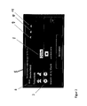
- Fig. 1 schematically shows the output of country information according to the known prior art.
- the output of country information 3 for a specific closed geographical area 2 takes place on a graphic output unit 1 Fig. 1 as well as the previous selection of the corresponding travel and / or traffic information from the map data storage device takes place when the navigation system approaches the boundary for the closed geographical area 2, exceeds a limit or is entered as part of a destination input process, a destination, which lies in the abutted geographical area 2 and the current position of the navigation system is not in the closed geographical area 2.
- a destination which lies in the abutted geographical area 2 and the current position of the navigation system is not in the closed geographical area 2.
- a plurality of country information 3 in the map data storage device of the navigation system in stock.
- the output includes a corresponding amount of travel and / or traffic information, which makes it less intuitive or only badly perceivable for the user.
- the user can selectively change the selection of the country information 3 to be output via the output unit 1 via the input unit 4 in the right-hand area of the output unit 1, he must, however, independently identify and interpret the traffic and / or travel information relevant for himself or in his situation ,
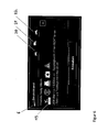
- Fig. 2 also shows the output unit 5 of a navigation system.
- the issued relevant travel and / or traffic situations 7 for the closed geographical area 6 have been determined or filtered out on the basis of a user profile as well as through a communication between the navigation system and an external, central data processing device.
- the profile output elements 9, 10 and 11 symbolize in the output of Fig. 2 the user profiles stored in the profile memory device of the navigation system. These can be, for example, predefined user profiles, such as cars, trucks or motorcycles.
- the navigation system can be selected as the combined input and output unit in the form of a touchscreen, each one of the user profiles as active user profile and / or changed and stored one of the user profiles with respect to at least one user property ,
- the output content 8 of the output unit 5 also indicates that the filtered and issued travel and / or traffic information 7 not only from the statically stored in the map data storage device travel and / or traffic information of the completed geographical area, but also a communication between the navigation system and a central, external data processing device has taken place. It is provided that a data request is sent to the data processing device, which in the case of Fig. 2 For example, the active user profile, so the profile "cars" and the completed geographical area 6 contains as request information. Thereupon, a comparison with the request information of the data request is executed by the travel and / or traffic information managed by the data processing device, wherein in the case of Fig.
- the travel and / or traffic information provided by the data processing device with such attributes and / or properties that a corresponding comparison provides a degree of agreement, based on which relevant travel and / or traffic information filtered out by the data processing device and by means of a data response to the navigation system be transmitted. It can be provided that the traffic and / or travel information received by data response replace or supplement the static traffic and / or travel information.
- the navigation system is set up to independently determine a user profile or at least user properties and to save them in the form of a user profile.
- a connection between the navigation system and an external communication device may be provided as an alternative to a communication device included in the navigation system. If necessary, the connection can be established via short-range radio or a cable connection.
- the time at which a data request is sent to the central data processing device can also be separated from the following output of the traffic and / or travel information. This allows timely receipt of the data response, reducing costs for data transmission, and enabling the received traffic and / or travel information to be output at a particularly advantageous time.
- the traffic and / or travel information received by means of the data response can also be, for example, currency rates, current news, events, holidays, school vacations, weather forecasts, special driving bans, blocked route sections, season-dependent speed limits, fuel prices and / or free rest - and resting places act.
- the travel and / or traffic information 13 also contains information that is specific to the management of a Passenger cars are tailored. For example, the obligation to carry a warning vest as well as a warning triangle, as prescribed in private geographic area 12 for passenger cars, is part of the travel and / or traffic information 13.
- the output of travel and / or traffic information 15 for the completed geographic area 12 is also different than that FIGS. 3 and 4 for example, if a "truck" profile is selected as the active user profile.
- the selected "truck" profile is a standardized truck profile, therefore the relevant travel and / or traffic information 15 includes information about trucks of different total weights.
- the user has changed or substantiated the activated user profile "truck” in such a way that further filtering of relevant travel and / or traffic information, also with regard to a total weight, can take place.
- the output travel and / or traffic information can be better adapted to the respective user situation and output accordingly clear and intuitive.
- Fig. 6 For the completed geographical area 6, further relevant traffic and / or travel information for the activated user profile "truck” is also shown. About the output elements 20 to 22 is also in the edition of Fig. 6 It can be seen that the user profile "Truck” is activated. Here, too, it can be seen that at least part of the issued travel and / or traffic information 19 has little to no relevance for a user who is traveling in a car or with a motorcycle. Accordingly, a significantly improved output of travel and / or traffic information can be achieved via the selective filtering of the travel and / or traffic information to be output on the basis of the activated user profile.
- Fig. 7 a situation is shown in which by means of a data request to an external, central data processing device in addition to an activated user profile and a closed geographical area and a sub-area was transmitted based on a calculated movement route 23 in the form of request information to the external data processing device.
- the data processing device can identify or filter out relevant travel and / or traffic information.
- Fig. 7 results in the comparison of the request information with the managed in the data processing device travel and / or traffic information that on a part of the route 23 for the day of driving a demonstration is announced and is therefore expected to traffic delays.
- the appropriately filtered travel and / or traffic information is transmitted by means of a data response to the navigation system and stored there at least temporarily.
- received travel and / or traffic information indicating a traffic disturbance in a geographical sub-area which was sent due to a calculated movement route as request information of a data request to an external data processing device leads to that from the navigation system automatically a recalculation of the movement route is initiated, which avoids the geographical sub-area of the original route 23.
- Fig. 8 a situation is shown in which a data request to the external data processing device and a subsequent filtering of relevant travel and / or traffic information by the data processing device has led to the result that the calculated route in a closed geographical area passes through a geographical subarea which is curvy.
- the filtering of current relevant travel and / or traffic information has led to the filtering of information regarding the travel weather. Due to the winding route of the movement route and the determined travel weather, the data processing device also filters out data on a service and sends it together with the travel and / or traffic information in the form of a data response to the navigation system.
- the data for the filtered service is a curve alert.
- the transmitted data is sufficient to carry out the service on the part of the navigation system.
- the user receives the possibility via the input unit 25 to execute the service or to reject it via the input unit 26.
- the service of the curve warning in the situation of Fig. 8 is a paid or free service, it can be provided that the settlement of the payment is also handled via the navigation system or connected via the navigation system peripherals.
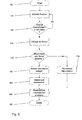
- Fig. 9 shows a flowchart of an embodiment of the method according to the invention.
- the method is first started in method step 100.
- the determination of the current position of the navigation system is carried out in method step 110.
- the distance to a boundary or, based on the change in distance becomes a boundary of a closed geographical This determines whether the navigation system is approaching a limit or has already exceeded a limit. If this is not the case, then the method is continued with method step 110.
- a data request to an external, central data processing device is generated and sent.
- the request information of the data request may include, for example, the request time, user properties or a user profile.
- the data request contains the completed geographical area to which an approach or for the border crossing was detected in step 120.
- request information may exist, for example, at the last time of a request for the completed geographic area.
- a geographical sub-region of the closed geographical area may be part of the data request in the form of request information.
- the filtering of relevant travel and / or traffic data by the data processing device is in the flowchart of Fig. 9 not shown for reasons of clarity.
- the filtering of relevant traffic and / or travel information based on the static travel and / or traffic information stored in the map data storage device is also described in US Pat Fig. 9 not shown.
- step 170 the travel and / or traffic information already stored is used for the corresponding completed geographical area stored actuality time or query time and / or expiration time is updated and in step 180, the stored travel and / or traffic information is filtered out and displayed.
- the navigation system receives a data response to the data request, then these data are stored in method step 150 on a memory device of the navigation system and stored or stored in method step 160 for the received travel and / or traffic information, a reception time, validity period and / or expiration time. On the basis of this value or of these values, validity or prioritization conflicts can be decided in the following in favor of the respectively more recent and thus more up-to-date travel and / or traffic information.
- the stored travel and / or traffic information is likewise filtered out and output to the user. The method is then terminated in method step 190.
Applications Claiming Priority (1)
| Application Number | Priority Date | Filing Date | Title |
|---|---|---|---|
| DE102010033043 | 2010-08-02 |
Publications (2)
| Publication Number | Publication Date |
|---|---|
| EP2416122A2 true EP2416122A2 (fr) | 2012-02-08 |
| EP2416122A3 EP2416122A3 (fr) | 2013-11-20 |
Family
ID=44675464
Family Applications (1)
| Application Number | Title | Priority Date | Filing Date |
|---|---|---|---|
| EP11176127.6A Withdrawn EP2416122A3 (fr) | 2010-08-02 | 2011-08-01 | Procédé destiné au fonctionnement d'un système de navigation |
Country Status (1)
| Country | Link |
|---|---|
| EP (1) | EP2416122A3 (fr) |
Cited By (4)
| Publication number | Priority date | Publication date | Assignee | Title |
|---|---|---|---|---|
| GB2523354A (en) * | 2014-02-21 | 2015-08-26 | Jaguar Land Rover Ltd | A system for use on a vehicle |
| US9909983B2 (en) | 2015-02-06 | 2018-03-06 | Asml Netherlands B.V. | Method and apparatus for improving measurement accuracy |
| WO2019121520A1 (fr) * | 2017-12-21 | 2019-06-27 | Continental Automotive Gmbh | Dispositif de commande de véhicule présentant une configuration géodépendante |
| FR3127303A1 (fr) * | 2021-09-20 | 2023-03-24 | Psa Automobiles Sa | Procédé et système pour transmettre des données caractérisant au moins un équipement obligatoire à bord d’un véhicule automobile |
Family Cites Families (7)
| Publication number | Priority date | Publication date | Assignee | Title |
|---|---|---|---|---|
| JP3548459B2 (ja) * | 1998-11-20 | 2004-07-28 | 富士通株式会社 | 案内情報提示装置,案内情報提示処理方法,案内情報提示プログラムを記録した記録媒体,案内用スクリプト生成装置,案内情報提供装置,案内情報提供方法および案内情報提供プログラム記録媒体 |
| JP2002168632A (ja) * | 2000-12-05 | 2002-06-14 | Alpine Electronics Inc | 受信情報処理装置 |
| EP1544576A1 (fr) * | 2003-12-17 | 2005-06-22 | Grundig Car InterMedia System GmbH | Dispositif de navigation pour véhicule à moteur avec informations améliorées pour le conducteur |
| JP2006177856A (ja) * | 2004-12-24 | 2006-07-06 | Denso Corp | ナビゲーション装置 |
| JP4177394B2 (ja) * | 2006-08-16 | 2008-11-05 | 本田技研工業株式会社 | ナビ装置、ナビサーバおよびナビシステム |
| DE102007055411A1 (de) * | 2007-08-29 | 2009-03-05 | Navigon Ag | Verfahren zum Betrieb einer Navigationseinrichtung |
| CN101556159A (zh) * | 2008-04-11 | 2009-10-14 | 联发科技(合肥)有限公司 | 全球导航卫星系统的安全导航方法及装置 |
-
2011
- 2011-08-01 EP EP11176127.6A patent/EP2416122A3/fr not_active Withdrawn
Non-Patent Citations (1)
| Title |
|---|
| None |
Cited By (5)
| Publication number | Priority date | Publication date | Assignee | Title |
|---|---|---|---|---|
| GB2523354A (en) * | 2014-02-21 | 2015-08-26 | Jaguar Land Rover Ltd | A system for use on a vehicle |
| GB2523354B (en) * | 2014-02-21 | 2017-12-06 | Jaguar Land Rover Ltd | System for aiding driver road use in a plurality of different geographical regions |
| US9909983B2 (en) | 2015-02-06 | 2018-03-06 | Asml Netherlands B.V. | Method and apparatus for improving measurement accuracy |
| WO2019121520A1 (fr) * | 2017-12-21 | 2019-06-27 | Continental Automotive Gmbh | Dispositif de commande de véhicule présentant une configuration géodépendante |
| FR3127303A1 (fr) * | 2021-09-20 | 2023-03-24 | Psa Automobiles Sa | Procédé et système pour transmettre des données caractérisant au moins un équipement obligatoire à bord d’un véhicule automobile |
Also Published As
| Publication number | Publication date |
|---|---|
| EP2416122A3 (fr) | 2013-11-20 |
Similar Documents
| Publication | Publication Date | Title |
|---|---|---|
| DE102017112279A1 (de) | Verfahren zur optimierung von fahrzeugzwischenabständen und gerechtes verteilen von kraftstoffeinsparungen in einer fahrzeugkolonne | |
| DE102011085893A1 (de) | Systeme und Verfahren zum Planen von Fahrzeugrouten auf Grundlage von Sicherheitsfaktoren | |
| DE102014217453A1 (de) | Autonome fahrzeugregelung für beeinträchtigten fahrer | |
| DE102017114605A1 (de) | Verfahren zum Betreiben eines Fahrerassistenzsystems für ein Kraftfahrzeug mit Bestimmung einer Trajektorie anhand eines Umgebungsszenarios, Fahrerassistenzsystem sowie Kraftfahrzeug | |
| DE102016008875A1 (de) | Verfahren zum Betrieb eines Fahrzeugs | |
| DE102018212238A1 (de) | Kontosystem, anbieter-endgerät, benutzer-endgerät, und knoten | |
| DE102018008045A1 (de) | Verfahren und Einrichtung zur Steuerung von Anzeigeinhalten auf einem Ausgabemittel eines Fahrzeugs | |
| EP2416122A2 (fr) | Procédé destiné au fonctionnement d'un système de navigation | |
| DE102006017845A1 (de) | System und Verfahren zur Parkbuchtreservierung für LKWs | |
| DE102020205425A1 (de) | Verfahren zum automatischen Informieren eines Nutzers im Fahrzeug über eine geltende Verkehrsvorschrift sowie ein Verkehrsvorschriften-Informationssystem | |
| WO2017157618A1 (fr) | Système et procédé pour assurer la navigation d'un véhicule et véhicule correspondant | |
| DE102018009716A1 (de) | Verfahren zur Bereitstellung von Kartendaten einer digitalen Karte und einer Fahrtroute | |
| WO2018114216A1 (fr) | Procédé de fonctionnement d'un véhicule à moteur à l'aide d'un dispositif de communication permettant de fournir un menu de commande d'un prestataire de services | |
| DE102012220357A1 (de) | Verfahren zur Ausgabe mindestens einer Geschwindigkeitsinformation in einem Fahrzeug, Informationssystem und Ausgabevorrichtung | |
| DE102017010482A1 (de) | Verfahren zur Aktualisierung von Kartendaten | |
| DE102006013297B4 (de) | Verfahren zum Betrieb eines Navigationssystems | |
| DE102016211045A1 (de) | Aktualisierung einer digitalen Karte | |
| DE102020111990A1 (de) | Verfahren, Vorrichtung und computerlesbares Speichermedium zum Auffinden eines Stellplatzes zum Parken eines Kraftfahrzeugs | |
| DE112011105119T5 (de) | Relationsinformationserzeugungsverfahren und Relationsinformationserzeugungsvorrichtung | |
| WO2021013603A1 (fr) | Procédé de négoce de cryptodevises | |
| EP1402232B1 (fr) | Procede et dispositif pour sortir des donnees relatives a un attribut d'une carte routiere numerique | |
| DE102019132618A1 (de) | Verfahren zum Betreiben einer Fahrzeugfunktion für ein Kraftfahrzeug | |
| DE102018214001B4 (de) | Verfahren zum Betreiben einer Ausgabeeinrichtung eines Kraftfahrzeugs, Kommunikationseinrichtung, Kraftfahrzeug, und Servervorrichtung zum Betreiben im Internet | |
| WO2017157617A1 (fr) | Procédé de fonctionnement d'un système de navigation | |
| DE102019000403A1 (de) | Verfahren zumindest zur Ausgabe einer Warnung vor einer Gefahrenstelle |
Legal Events
| Date | Code | Title | Description |
|---|---|---|---|
| AK | Designated contracting states |
Kind code of ref document: A2 Designated state(s): AL AT BE BG CH CY CZ DE DK EE ES FI FR GB GR HR HU IE IS IT LI LT LU LV MC MK MT NL NO PL PT RO RS SE SI SK SM TR |
|
| AX | Request for extension of the european patent |
Extension state: BA ME |
|
| PUAI | Public reference made under article 153(3) epc to a published international application that has entered the european phase |
Free format text: ORIGINAL CODE: 0009012 |
|
| PUAL | Search report despatched |
Free format text: ORIGINAL CODE: 0009013 |
|
| AK | Designated contracting states |
Kind code of ref document: A3 Designated state(s): AL AT BE BG CH CY CZ DE DK EE ES FI FR GB GR HR HU IE IS IT LI LT LU LV MC MK MT NL NO PL PT RO RS SE SI SK SM TR |
|
| AX | Request for extension of the european patent |
Extension state: BA ME |
|
| RIC1 | Information provided on ipc code assigned before grant |
Ipc: G01C 21/36 20060101AFI20131011BHEP |
|
| STAA | Information on the status of an ep patent application or granted ep patent |
Free format text: STATUS: THE APPLICATION IS DEEMED TO BE WITHDRAWN |
|
| 18D | Application deemed to be withdrawn |
Effective date: 20140301 |