EP2416122A2 - Method for operating a navigation system - Google Patents
Method for operating a navigation system Download PDFInfo
- Publication number
- EP2416122A2 EP2416122A2 EP11176127A EP11176127A EP2416122A2 EP 2416122 A2 EP2416122 A2 EP 2416122A2 EP 11176127 A EP11176127 A EP 11176127A EP 11176127 A EP11176127 A EP 11176127A EP 2416122 A2 EP2416122 A2 EP 2416122A2
- Authority
- EP
- European Patent Office
- Prior art keywords
- information
- travel
- traffic
- data
- processing device
- Prior art date
- Legal status (The legal status is an assumption and is not a legal conclusion. Google has not performed a legal analysis and makes no representation as to the accuracy of the status listed.)
- Withdrawn
Links
Images


Classifications
-
- G—PHYSICS
- G01—MEASURING; TESTING
- G01C—MEASURING DISTANCES, LEVELS OR BEARINGS; SURVEYING; NAVIGATION; GYROSCOPIC INSTRUMENTS; PHOTOGRAMMETRY OR VIDEOGRAMMETRY
- G01C21/00—Navigation; Navigational instruments not provided for in groups G01C1/00 - G01C19/00
- G01C21/26—Navigation; Navigational instruments not provided for in groups G01C1/00 - G01C19/00 specially adapted for navigation in a road network
- G01C21/34—Route searching; Route guidance
- G01C21/36—Input/output arrangements for on-board computers
- G01C21/3691—Retrieval, searching and output of information related to real-time traffic, weather, or environmental conditions
-
- G—PHYSICS
- G01—MEASURING; TESTING
- G01C—MEASURING DISTANCES, LEVELS OR BEARINGS; SURVEYING; NAVIGATION; GYROSCOPIC INSTRUMENTS; PHOTOGRAMMETRY OR VIDEOGRAMMETRY
- G01C21/00—Navigation; Navigational instruments not provided for in groups G01C1/00 - G01C19/00
- G01C21/26—Navigation; Navigational instruments not provided for in groups G01C1/00 - G01C19/00 specially adapted for navigation in a road network
- G01C21/34—Route searching; Route guidance
- G01C21/36—Input/output arrangements for on-board computers
- G01C21/3626—Details of the output of route guidance instructions
- G01C21/3641—Personalized guidance, e.g. limited guidance on previously travelled routes
-
- G—PHYSICS
- G01—MEASURING; TESTING
- G01C—MEASURING DISTANCES, LEVELS OR BEARINGS; SURVEYING; NAVIGATION; GYROSCOPIC INSTRUMENTS; PHOTOGRAMMETRY OR VIDEOGRAMMETRY
- G01C21/00—Navigation; Navigational instruments not provided for in groups G01C1/00 - G01C19/00
- G01C21/26—Navigation; Navigational instruments not provided for in groups G01C1/00 - G01C19/00 specially adapted for navigation in a road network
- G01C21/34—Route searching; Route guidance
- G01C21/36—Input/output arrangements for on-board computers
- G01C21/3626—Details of the output of route guidance instructions
- G01C21/3655—Timing of guidance instructions
-
- G—PHYSICS
- G01—MEASURING; TESTING
- G01C—MEASURING DISTANCES, LEVELS OR BEARINGS; SURVEYING; NAVIGATION; GYROSCOPIC INSTRUMENTS; PHOTOGRAMMETRY OR VIDEOGRAMMETRY
- G01C21/00—Navigation; Navigational instruments not provided for in groups G01C1/00 - G01C19/00
- G01C21/26—Navigation; Navigational instruments not provided for in groups G01C1/00 - G01C19/00 specially adapted for navigation in a road network
- G01C21/34—Route searching; Route guidance
- G01C21/36—Input/output arrangements for on-board computers
- G01C21/3697—Output of additional, non-guidance related information, e.g. low fuel level
Definitions
- Known navigation systems generally have a map data storage device in which geographical maps, particularly road maps, are stored for a large geographic area.
- a route calculation which also takes place over state and / or state borders, and to carry out a route guidance on the basis of such a route calculation ,
- Generic navigation systems having map data on a correspondingly large geographic area are also adapted to provide the user, in many cases the driver of a motor vehicle, with information prior to or at a border crossing into another country or state , or generally in the case of an imminent entry into a closed geographical area for which users are important or informative.
- Such information may include, for example, road traffic regulations, which may vary according to legislation in the country or state concerned.
- country information is stored in generic navigation systems, which are output to the user in various situations.
- Such a situation is given, for example, when the navigation system approaches a border to another country or when the user, in the context of a destination input process, determines a destination in a country which does not correspond to the country of the current position of the navigation system.
- a disadvantage of the known approaches to the output of country information is that the country information stored statically in the navigation system and accordingly in the aforementioned situations are issued equally static or flat rate to the user. This inevitably means that either only a minimum amount of country information is output to the user in order not to confuse or overwhelm him or to distract the user's attention from the traffic. However, such a minimized output of country information may result in the absence of particularly important information for the user, which may result in the risk of violations of traffic regulations or even hazardous situations.
- country information that is as extensive as possible to be output.
- most relevant information is included in the country information with high probability, but it is, as previously indicated, taken into account that the user is distracted from the traffic to a considerable extent to take or to take the information that is informative for him from the amount of country information.
- the inventive method is based on the basic idea that in the navigation system at least one user profile, which includes at least one user property, stored in a profile database and during operation of the Navigationssytems at least one stored user profile can be determined as an active user profile, wherein in a situation in which the output of country information is meaningful, such as when approaching a boundary of a closed geographical area, traffic and / or travel information regarding the closed geographical area depending on the active user profile filtered out and those in the filtering as relevant to the user or as relevant for the user profile considered traffic and / or travel information are issued.
- a navigation system operated by the method according to the invention comprises a map data storage device in which map data of a geographical area are stored and the map data also include traffic and / or travel information regarding closed geographical areas.
- the navigation system comprises a position determination device with which the geographical position of the navigation system can be determined, a route calculation unit with which a movement route from a starting point to a destination point can be calculated, and at least one input unit with which user inputs can be made.
- a corresponding navigation system has an output unit with which outputs can be output to a user, as well as the already mentioned profile database for storing user profiles.
- the traffic and / or travel information can in principle be any information which has an information content for the different users and user situations and thus makes traveling or moving with the assistance of a navigation system easier or more comfortable.
- the method according to the invention provides in a first method step that the determination of the current position of the navigation system takes place. This can be done by means of the position-determining device, wherein the position-determining device can be set up, for example, to receive GPS signals and to process and interpret them. Alternatively, however, the position-determining device can also be set up for position determination by means of other basically known methods.
- the determination of the distance and / or the change in distance between the current position of the navigation system takes place on the basis of the map data of the map data storage device and on the basis of the determined current position of the navigation system and at least one boundary of a closed geographical area. This may determine or at least estimate if and when a border crossing into another closed geographical area is imminent or likely. This applies in particular even if there is no route guidance by means of the navigation system from a starting point to a destination point.
- the filtering of relevant traffic and / or travel information with respect to at least one closed geographical area depending on the distance and / or the change in distance between the current position and at least one boundary of at least one completed geographic area and depending on the active user profile ensures that out of the entirety of the travel and / or traffic information contained in the map data storage device, only the information concerning the closed geographical area in which a border crossing is imminent or likely to be filtered out, whereby for the respective closed area only those traffic and / or travel information that has some relevance to the user.
- the relevance for the user can be done by comparing the user profile or the user properties of the user profile with the traffic and / or travel information of the map data storage device.
- the output of the filtered traffic and / or Travel information with at least one output device of the navigation system. Since the issued traffic and / or travel information on the user profile adapted to the user situation and reduced to a corresponding closed area, the user can be issued despite a minimum amount of information output a maximum amount of information relevant to him or for the current user situation , This in turn ensures a fast intuitive and safe recording or interpretation of the relevant traffic and / or travel information by the user.
- an advantageous embodiment of the method according to the invention provides that further method steps are provided after the second and before the third method step, which generally include communication between the navigation system and an external central data processing device for determining and transmitting further situation-specific traffic and / or travel information allow.
- the navigation system comprises at least one communication device, by means of which data with an external, central data processing device are interchangeable, the data processing device is in turn set up for the management and storage of travel and / or traffic information regarding closed areas.
- the additional method steps provide that first of all a data request from the navigation system by means of the communication device to the data processing device is sent, which comprises at least one request information.
- the request information is provided in order to generate the most specific request possible of travel and / or traffic information.
- the data processing device filters out relevant travel and / or traffic information by means of a comparison of the at least one request information with the travel and / or traffic information of the data processing device.
- the traffic and / or travel information of the data processing device comprise determination and / or comparison properties, by means of which a comparison and as a result of the comparison a filtering of travel and / or traffic information based on the at least one request information can be done.
- a data response generated by the data processing device is transmitted to the navigation system, wherein the data response relevant traffic and / or travel information includes, and wherein the received data of the data response for filtering and / or output relevant traffic and / or travel information can be used by means of the navigation system.
- the traffic and / or travel information finally output is even better adapted to the current situation of the user and the situation in the at least one closed area.
- a further refinement of the method according to the invention provides that the data request is generated as a function of the distance and / or the change in distance between the current position of the navigation system and at least one boundary of at least one closed geographical area and at least one closed geographical area in the form of request information is sent to the data processing device.
- a data response is generated which, based on the comparison of the request information with the traffic and / or travel information of the data processing device only traffic and / or Travel information regarding the completed geographical area, which was identified based on the request information.
- the travel and traffic information stored in the data processing device can be assigned to at least one closed geographical area and the filtering of relevant travel and traffic information takes place as a function of the received request information.
- standardized and / or user-specific user profiles can be stored by means of the profile storage device of the navigation system, in a data request to the central data processing device at least one user property of the respective active user profile or the active user profile is sent in the form of request information to the data processing device ,
- the travel and / or traffic information managed by the data processing device can be accessed via attributes resp Have properties that allow comparison or matching with user properties or user profiles.
- the data transmitted by the data processing device to the navigation system by means of the data response also have a high temporal relevance and a high relevance with regard to the user profile and thus with regard to the situation of the user.
- optimally tailored travel and / or traffic information can be output to the user for the respective situation. For example, very different current traffic and / or travel information for a closed area may be informative for a car driver or motorcyclist.
- an embodiment of the method provides that, in the case of a data request, at least part of a calculated movement route within at least one closed geographical area is sent to the data processing device in the form of request information.
- the calculated movement route may be a movement route calculated based on a specific starting point and a specific destination, as well as a route of movement automatically calculated by the navigation system as the most likely route of movement.
- travel and / or traffic information stored in the data processing device can be assigned to a geographical subarea of a closed geographical area and the relevant travel and / or traffic information is filtered out as a function of the received request information.
- travel and / or traffic information can be filtered out by the data processing device and sent as a data response to the navigation system, which in the case of the corresponding request information relates specifically and selectively to a subarea of a geographically closed area that is likely or actually to be traversed in the future.
- information on weather conditions in at least one subarea of a closed geographical area or fuel prices in a subarea of a closed geographical area can thereby be selectively filtered out to the respective request information of the navigation system and in turn sent back to the latter via data response.
- an advantageous embodiment of the method according to the invention in that, in the case of a data request, the time of the last data request of traffic and / or travel information relating to the respective at least one completed geographical area is sent in the form of request information to the data processing device.
- the data requests or at least part of the data requests are stored by the navigation system.
- an advantageous embodiment of the method provides that the travel and / or traffic information stored in the data processing device be assigned a creation and / or expiration time can and filtering the relevant travel and traffic information in response to the received request information is done. Accordingly, when filtering out relevant travel and / or traffic information when transmitting corresponding request information, those travel and / or traffic information which has changed since the last request or has been newly created since the last request or became invalid after the last request can be filtered out.
- an embodiment provides that the traffic and / or travel information received by the data processing device is stored in a memory device of the navigation system, with the traffic and / or travel information also the time of receipt of the data response is stored. This can be an unnecessarily frequent generation of Data requests to the data processing device can be prevented. In addition, a comparison of already stored traffic and / or travel information with newly obtained traffic and / or travel information with regard to the validity or higher actuality can thereby also take place.
- an advantageous embodiment of the method provides that the traffic and / or travel information received by the data processing device with a data response are stored in the navigation system with a validity period depending on the type of traffic and / or travel information.
- the traffic and / or travel information held by the navigation system can also be kept as up-to-date as possible, and redundant data requests to the data processing device can also be reduced or completely omitted.
- a further advantageous embodiment of the method according to the invention provides that the data response received from the data processing device also transmits data on goods and services, wherein the goods and services can be offered and / or executed via the navigation system by means of the data of the data response. These may be both free of charge and chargeable goods and services or their offers. For paid goods and services is also provided that the settlement of payment by the navigation system and / or related peripherals can be done.
- an embodiment of the method provides that the filtering and displaying of relevant travel and traffic information by the navigation system and / or the sending of a data request to an external, central data processing device also includes determining a destination of a route and determining boundaries of closed geographical areas between the destination point of the route and the current position of the navigation system can take place.
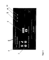
- Fig. 1 schematically shows the output of country information according to the known prior art.
- the output of country information 3 for a specific closed geographical area 2 takes place on a graphic output unit 1 Fig. 1 as well as the previous selection of the corresponding travel and / or traffic information from the map data storage device takes place when the navigation system approaches the boundary for the closed geographical area 2, exceeds a limit or is entered as part of a destination input process, a destination, which lies in the abutted geographical area 2 and the current position of the navigation system is not in the closed geographical area 2.
- a destination which lies in the abutted geographical area 2 and the current position of the navigation system is not in the closed geographical area 2.
- a plurality of country information 3 in the map data storage device of the navigation system in stock.
- the output includes a corresponding amount of travel and / or traffic information, which makes it less intuitive or only badly perceivable for the user.
- the user can selectively change the selection of the country information 3 to be output via the output unit 1 via the input unit 4 in the right-hand area of the output unit 1, he must, however, independently identify and interpret the traffic and / or travel information relevant for himself or in his situation ,
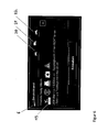
- Fig. 2 also shows the output unit 5 of a navigation system.
- the issued relevant travel and / or traffic situations 7 for the closed geographical area 6 have been determined or filtered out on the basis of a user profile as well as through a communication between the navigation system and an external, central data processing device.
- the profile output elements 9, 10 and 11 symbolize in the output of Fig. 2 the user profiles stored in the profile memory device of the navigation system. These can be, for example, predefined user profiles, such as cars, trucks or motorcycles.
- the navigation system can be selected as the combined input and output unit in the form of a touchscreen, each one of the user profiles as active user profile and / or changed and stored one of the user profiles with respect to at least one user property ,
- the output content 8 of the output unit 5 also indicates that the filtered and issued travel and / or traffic information 7 not only from the statically stored in the map data storage device travel and / or traffic information of the completed geographical area, but also a communication between the navigation system and a central, external data processing device has taken place. It is provided that a data request is sent to the data processing device, which in the case of Fig. 2 For example, the active user profile, so the profile "cars" and the completed geographical area 6 contains as request information. Thereupon, a comparison with the request information of the data request is executed by the travel and / or traffic information managed by the data processing device, wherein in the case of Fig.
- the travel and / or traffic information provided by the data processing device with such attributes and / or properties that a corresponding comparison provides a degree of agreement, based on which relevant travel and / or traffic information filtered out by the data processing device and by means of a data response to the navigation system be transmitted. It can be provided that the traffic and / or travel information received by data response replace or supplement the static traffic and / or travel information.
- the navigation system is set up to independently determine a user profile or at least user properties and to save them in the form of a user profile.
- a connection between the navigation system and an external communication device may be provided as an alternative to a communication device included in the navigation system. If necessary, the connection can be established via short-range radio or a cable connection.
- the time at which a data request is sent to the central data processing device can also be separated from the following output of the traffic and / or travel information. This allows timely receipt of the data response, reducing costs for data transmission, and enabling the received traffic and / or travel information to be output at a particularly advantageous time.
- the traffic and / or travel information received by means of the data response can also be, for example, currency rates, current news, events, holidays, school vacations, weather forecasts, special driving bans, blocked route sections, season-dependent speed limits, fuel prices and / or free rest - and resting places act.
- the travel and / or traffic information 13 also contains information that is specific to the management of a Passenger cars are tailored. For example, the obligation to carry a warning vest as well as a warning triangle, as prescribed in private geographic area 12 for passenger cars, is part of the travel and / or traffic information 13.
- the output of travel and / or traffic information 15 for the completed geographic area 12 is also different than that FIGS. 3 and 4 for example, if a "truck" profile is selected as the active user profile.
- the selected "truck" profile is a standardized truck profile, therefore the relevant travel and / or traffic information 15 includes information about trucks of different total weights.
- the user has changed or substantiated the activated user profile "truck” in such a way that further filtering of relevant travel and / or traffic information, also with regard to a total weight, can take place.
- the output travel and / or traffic information can be better adapted to the respective user situation and output accordingly clear and intuitive.
- Fig. 6 For the completed geographical area 6, further relevant traffic and / or travel information for the activated user profile "truck” is also shown. About the output elements 20 to 22 is also in the edition of Fig. 6 It can be seen that the user profile "Truck” is activated. Here, too, it can be seen that at least part of the issued travel and / or traffic information 19 has little to no relevance for a user who is traveling in a car or with a motorcycle. Accordingly, a significantly improved output of travel and / or traffic information can be achieved via the selective filtering of the travel and / or traffic information to be output on the basis of the activated user profile.
- Fig. 7 a situation is shown in which by means of a data request to an external, central data processing device in addition to an activated user profile and a closed geographical area and a sub-area was transmitted based on a calculated movement route 23 in the form of request information to the external data processing device.
- the data processing device can identify or filter out relevant travel and / or traffic information.
- Fig. 7 results in the comparison of the request information with the managed in the data processing device travel and / or traffic information that on a part of the route 23 for the day of driving a demonstration is announced and is therefore expected to traffic delays.
- the appropriately filtered travel and / or traffic information is transmitted by means of a data response to the navigation system and stored there at least temporarily.
- received travel and / or traffic information indicating a traffic disturbance in a geographical sub-area which was sent due to a calculated movement route as request information of a data request to an external data processing device leads to that from the navigation system automatically a recalculation of the movement route is initiated, which avoids the geographical sub-area of the original route 23.
- Fig. 8 a situation is shown in which a data request to the external data processing device and a subsequent filtering of relevant travel and / or traffic information by the data processing device has led to the result that the calculated route in a closed geographical area passes through a geographical subarea which is curvy.
- the filtering of current relevant travel and / or traffic information has led to the filtering of information regarding the travel weather. Due to the winding route of the movement route and the determined travel weather, the data processing device also filters out data on a service and sends it together with the travel and / or traffic information in the form of a data response to the navigation system.
- the data for the filtered service is a curve alert.
- the transmitted data is sufficient to carry out the service on the part of the navigation system.
- the user receives the possibility via the input unit 25 to execute the service or to reject it via the input unit 26.
- the service of the curve warning in the situation of Fig. 8 is a paid or free service, it can be provided that the settlement of the payment is also handled via the navigation system or connected via the navigation system peripherals.
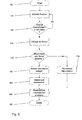
- Fig. 9 shows a flowchart of an embodiment of the method according to the invention.
- the method is first started in method step 100.
- the determination of the current position of the navigation system is carried out in method step 110.
- the distance to a boundary or, based on the change in distance becomes a boundary of a closed geographical This determines whether the navigation system is approaching a limit or has already exceeded a limit. If this is not the case, then the method is continued with method step 110.
- a data request to an external, central data processing device is generated and sent.
- the request information of the data request may include, for example, the request time, user properties or a user profile.
- the data request contains the completed geographical area to which an approach or for the border crossing was detected in step 120.
- request information may exist, for example, at the last time of a request for the completed geographic area.
- a geographical sub-region of the closed geographical area may be part of the data request in the form of request information.
- the filtering of relevant travel and / or traffic data by the data processing device is in the flowchart of Fig. 9 not shown for reasons of clarity.
- the filtering of relevant traffic and / or travel information based on the static travel and / or traffic information stored in the map data storage device is also described in US Pat Fig. 9 not shown.
- step 170 the travel and / or traffic information already stored is used for the corresponding completed geographical area stored actuality time or query time and / or expiration time is updated and in step 180, the stored travel and / or traffic information is filtered out and displayed.
- the navigation system receives a data response to the data request, then these data are stored in method step 150 on a memory device of the navigation system and stored or stored in method step 160 for the received travel and / or traffic information, a reception time, validity period and / or expiration time. On the basis of this value or of these values, validity or prioritization conflicts can be decided in the following in favor of the respectively more recent and thus more up-to-date travel and / or traffic information.
- the stored travel and / or traffic information is likewise filtered out and output to the user. The method is then terminated in method step 190.
Abstract
Description
Bekannte Navigationssysteme verfügen im Allgemeinen über eine Kartendatenspeichereinrichtung, in der geographische Karten, insbesondere Straßenkarten, für ein großes geographisches Gebiet gespeichert sind. Mit einer zunehmenden Größe des in der Kartendatenspeichereinrichtung gespeicherten Kartenmaterials bzw. mit zunehmender Größe des anhand des Kartenmaterials beschriebenen geographischen Gebiets besteht beispielsweise die Möglichkeit, eine Routenberechnung vorzunehmen, die auch über Landes- und/oder Staatsgrenzen erfolgt, sowie eine Zielführung anhand einer derartigen Routenberechnung durchzuführen.Known navigation systems generally have a map data storage device in which geographical maps, particularly road maps, are stored for a large geographic area. With an increasing size of the map material stored in the map data storage device or with increasing size of the geographical area described with reference to the map material, for example, it is possible to carry out a route calculation, which also takes place over state and / or state borders, and to carry out a route guidance on the basis of such a route calculation ,
Gattungsgemäße Navigationssysteme, die über Kartendaten zu einem entsprechend großen geographischen Gebiet verfügen, sind zudem dazu eingerichtet, den Benutzer, in vielen Fällen den Führer eines Kraftfahrzeugs, mit Informationen zu versorgen, die vor oder bei einem Grenzübertritt in ein anderes Land bzw. einen anderen Staat, oder allgemein bei einem bevorstehenden Übertritt in ein abgeschlossenes geographisches Gebiet, für den Benutzer wichtig bzw. informativ sind. Bei derartigen Informationen handelt es sich beispielsweise um Vorschriften zum Straßenverkehr, die je nach Gesetzgebung in dem entsprechenden Land bzw. Staat unterschiedlich sein können.Generic navigation systems having map data on a correspondingly large geographic area are also adapted to provide the user, in many cases the driver of a motor vehicle, with information prior to or at a border crossing into another country or state , or generally in the case of an imminent entry into a closed geographical area for which users are important or informative. Such information may include, for example, road traffic regulations, which may vary according to legislation in the country or state concerned.
Um dem Benutzer bei einem Grenzübertritt Informationen ausgeben zu können, sind in gattungsgemäßen Navigationssystemen so genannte Länderinformationen hinterlegt, die in verschiedenen Situationen an den Benutzer ausgegeben werden. Eine solche Situation ist beispielsweise dann gegeben, wenn sich das Navigationssystem einer Grenze zu einem anderen Land nähert bzw. wenn der Benutzer im Rahmen eines Zieleingabeprozesses ein Ziel in einem Land bestimmt, welches nicht dem Land der aktuellen Position des Navigationssystems entspricht.In order to be able to output information to the user when crossing a border, so-called country information is stored in generic navigation systems, which are output to the user in various situations. Such a situation is given, for example, when the navigation system approaches a border to another country or when the user, in the context of a destination input process, determines a destination in a country which does not correspond to the country of the current position of the navigation system.
Nachteilig an den bekannten Ansätzen zur Ausgabe von Länderinformationen ist dabei, dass die Länderinformationen statisch im Navigationssystem hinterlegt und dementsprechend in den voran genannten Situationen gleichermaßen statisch bzw. pauschal an den Benutzer ausgegeben werden. Dies hat unweigerlich zur Folge, dass entweder nur ein Mindestmaß an Länderinformation an den Benutzer ausgegeben wird, um diesen nicht zu verwirren bzw. zu überfordern und die Aufmerksamkeit des Benutzers nicht über Gebühr vom Verkehrsgeschehen abzulenken. Bei einer derart minimalisierten Ausgabe von Länderinformationen kann es jedoch dazu kommen, dass besonders wichtige Informationen für den Benutzer nicht enthalten sind, wodurch die Gefahr von Verstößen gegen Verkehrsregeln oder sogar Gefahrensituationen entstehen können.A disadvantage of the known approaches to the output of country information is that the country information stored statically in the navigation system and accordingly in the aforementioned situations are issued equally static or flat rate to the user. This inevitably means that either only a minimum amount of country information is output to the user in order not to confuse or overwhelm him or to distract the user's attention from the traffic. However, such a minimized output of country information may result in the absence of particularly important information for the user, which may result in the risk of violations of traffic regulations or even hazardous situations.
Alternativ kann beim statischen Auslesen und Ausgeben von Länderinformationen bei bekannten Navigationssystemen ebenfalls vorgesehen sein, dass möglichst umfängliche Länderinformationen ausgegeben werden. Damit sind zwar mit hoher Wahrscheinlichkeit auch die für den Benutzer in der jeweiligen aktuellen Situation am meisten relevanten Informationen in den Länderinformationen enthalten, es wird jedoch, wie vorangegangen bereits angedeutet, in Kauf genommen, dass der Benutzer in erheblichem Maß vom Verkehrsgeschehen abgelenkt wird, um die jeweils für ihn informativen Angaben aus der Menge der Länderinformation zu entnehmen bzw. wahrzunehmen.Alternatively, in the case of static reading and outputting of country information in known navigation systems, provision can also be made for country information that is as extensive as possible to be output. Thus, although the most relevant for the user in the current situation most relevant information is included in the country information with high probability, but it is, as previously indicated, taken into account that the user is distracted from the traffic to a considerable extent to take or to take the information that is informative for him from the amount of country information.
Zusammenfassend bestehen die Nachteile beim Betrieb bekannter Navigationssysteme im Hinblick auf die Ausgabe von Länderinformation darin, dass durch die statische Hinterlegung und dadurch bedingte unselektive Ausgabe der Länderinformationen keinerlei Anpassung an die Situation des Bedieners möglich ist und deshalb der individuelle Nutzen der Ausgabe von Länderinformationen für einen Bediener mitunter äußerst gering ausfallen kann.In summary, the disadvantages of operating known navigation systems with respect to the issuance of country information is that the static storage and consequent unselective output of the country information does not allow any adjustment to the operator's situation and therefore the individual benefit of outputting country information to an operator sometimes extremely small.
Ausgehend von diesem Stand der Technik ist es deshalb Aufgabe der vorliegenden Erfindung, ein Verfahren zum Betrieb eines Navigationssystems vorzuschlagen, mit dem die Ausgabe von Länderinformationen optimal an die jeweilige Gesamtsituation des Bedieners angepasst und dadurch eine optimale Information des Bedieners ermöglicht wird.Based on this prior art, it is therefore an object of the present invention to propose a method for operating a navigation system, with which the output of country information optimally adapted to the respective overall situation of the operator and thereby optimal information of the operator is enabled.
Diese Aufgabe wird durch ein Verfahren nach der Lehre des Anspruchs 1 gelöst.This object is achieved by a method according to the teaching of
Vorteilhafte Ausführungsformen der Erfindung sind Gegenstand der Unteransprüche.Advantageous embodiments of the invention are the subject of the dependent claims.
Das erfindungsgemäße Verfahren beruht dabei auf der Grundüberlegung, dass im Navigationssystem zumindest ein Benutzerprofil, welches zumindest eine Benutzereigenschaft umfasst, in einer Profildatenbank gespeichert und während des Betriebs des Navigationssytems zumindest ein gespeichertes Benutzerprofil als aktives Benutzerprofil bestimmt werden kann, wobei in einer Situation, in der die Ausgabe von Länderinformationen sinnvoll ist, wie beispielsweise bei der Annäherung an eine Grenze eines abgeschlossenen geographischen Gebiets, Verkehrs-und/oder Reiseinformationen bezüglich des abgeschlossenen geographischen Gebiets in Abhängigkeit des aktiven Benutzerprofils ausgefiltert und die bei der Ausfilterung als relevant für den Benutzer bzw. als relevant für das Benutzerprofil erachteten Verkehrs- und/oder Reiseinformationen ausgegeben werden.The inventive method is based on the basic idea that in the navigation system at least one user profile, which includes at least one user property, stored in a profile database and during operation of the Navigationssytems at least one stored user profile can be determined as an active user profile, wherein in a situation in which the output of country information is meaningful, such as when approaching a boundary of a closed geographical area, traffic and / or travel information regarding the closed geographical area depending on the active user profile filtered out and those in the filtering as relevant to the user or as relevant for the user profile considered traffic and / or travel information are issued.
Dabei ist vorgesehen, dass ein mit dem erfindungsgemäßen Verfahren betriebenes Navigationsystem eine Kartendatenspeichereinrichtung umfasst, in der Kartendaten eines geographischen Gebiets gespeichert sind und die Kartendaten auch Verkehrs- und/oder Reiseinformationen bezüglich abgeschlossener geographischer Gebiete umfassen. Zudem umfasst das Navigationssystem eine Positionsbestimmungseinrichtung, mit der die geographische Position des Navigationssystems bestimmt werden kann, eine Routenberechnungseinheit, mit der eine Bewegungsroute von einem Startpunkt zu einem Zielpunkt berechnet werden kann, sowie zumindest eine Eingabeeinheit, mit der Benutzereingaben getätigt werden können. Weiter ist vorgesehen, dass ein entsprechendes Navigationssystem eine Ausgabeeinheit aufweist, mit der Ausgaben an einen Benutzer ausgegeben werden können, sowie die bereits genannte Profildatenbank zur Speicherung von Benutzerprofilen.It is provided that a navigation system operated by the method according to the invention comprises a map data storage device in which map data of a geographical area are stored and the map data also include traffic and / or travel information regarding closed geographical areas. In addition, the navigation system comprises a position determination device with which the geographical position of the navigation system can be determined, a route calculation unit with which a movement route from a starting point to a destination point can be calculated, and at least one input unit with which user inputs can be made. It is further provided that a corresponding navigation system has an output unit with which outputs can be output to a user, as well as the already mentioned profile database for storing user profiles.
Bei den Verkehrs- und/oder Reiseinformationen kann es sich um grundsätzlich beliebige Informationen handeln, die für die unterschiedlichen Benutzer und Benutzersituationen einen Informationsgehalt aufweisen und damit das Reisen bzw. Bewegen mit Unterstützung eines Navigationssystems erleichtern oder komfortabler gestalten.The traffic and / or travel information can in principle be any information which has an information content for the different users and user situations and thus makes traveling or moving with the assistance of a navigation system easier or more comfortable.
Das erfindungsgemäße Verfahren sieht dabei in einem ersten Verfahrensschritt vor, dass die Bestimmung der aktuellen Position des Navigationssystems erfolgt. Dies kann mittels der Positionsbestimmungseinrichtung erfolgen, wobei die Positionsbestimmungseinrichtung beispielweise zum Empfang von GPS-Signalen sowie zu deren Verarbeitung und Interpretation eingerichtet sein kann. Alternativ kann die Positionsbestimmungseinrichtung jedoch auch zur Positionsbestimmung anhand anderer grundsätzlich bekannter Verfahren eingerichtet sein.The method according to the invention provides in a first method step that the determination of the current position of the navigation system takes place. This can be done by means of the position-determining device, wherein the position-determining device can be set up, for example, to receive GPS signals and to process and interpret them. Alternatively, however, the position-determining device can also be set up for position determination by means of other basically known methods.
In einem zweiten Verfahrensschritt erfolgt anhand der Kartendaten der Kartendatenspeichereinrichtung und anhand der bestimmten aktuellen Position des Navigationssystems die Bestimmung des Abstands und/oder der Abstandsänderung zwischen der aktuellen Position des Navigationssystems und zumindest einer Grenze eines abgeschlossenen geographischen Gebiets. Dadurch kann festgelegt oder zumindest abgeschätzt werden, ob und wann ein Grenzübergang in ein anderes abgeschlossenes geographisches Gebiet bevorsteht oder wahrscheinlich ist. Dies gilt insbesondere auch dann, wenn keine Routenführung mittels des Navigationssystems von einem Startpunkt zu einem Zielpunkt erfolgt.In a second method step, the determination of the distance and / or the change in distance between the current position of the navigation system takes place on the basis of the map data of the map data storage device and on the basis of the determined current position of the navigation system and at least one boundary of a closed geographical area. This may determine or at least estimate if and when a border crossing into another closed geographical area is imminent or likely. This applies in particular even if there is no route guidance by means of the navigation system from a starting point to a destination point.
In einem darauf folgenden Verfahrensschritt des erfindungsgemäßen Verfahrens erfolgt das Ausfiltern von relevanten Verkehrs- und/oder Reiseinformationen bezüglich zumindest eines abgeschlossenen geographischen Gebiets in Abhängigkeit vom Abstand und/oder von der Abstandsänderung zwischen der aktuellen Position und zumindest einer Grenze von zumindest einem abgeschlossenen geographischen Gebiet und in Abhängigkeit vom jeweils aktiven Benutzerprofil. Damit wird sichergestellt, dass aus der Gesamtheit der in der Kartendatenspeichereinrichtung enthaltenen Reise- und/oder Verkehrsinformationen nur die Informationen ausgefiltert werden, die das abgeschlossene geographische Gebiet betreffen, in das ein Grenzübergang bevorsteht oder wahrscheinlich ist, wobei für das jeweilige abgeschlossene Gebiet nur diejenigen Verkehrs- und/oder Reiseinformationen ausgefiltert werden, die eine gewisse Relevanz für den Benutzer aufweisen. Die Relevanz für den Benutzer kann dabei durch einen Vergleich des Benutzerprofils bzw. der Benutzereigenschaften des Benutzerprofils mit den Verkehrs-und/oder Reiseinformationen der Kartendatenspeichereinrichtung erfolgen. Dazu kann in grundsätzlich bekannter Weise vorgesehen sein, dass auch den Verkehrs- und/oder Reiseinformationen einzelne Benutzerprofile und/oder Benutzereigenschaften zugeordnet sind oder gegebenenfalls ein relativer Übereinstimmungswert zugewiesen ist, womit der Vergleich und ein Ausfiltern anhand entsprechender Übereinstimmungskriterien ermöglicht werden.In a subsequent method step of the method according to the invention, the filtering of relevant traffic and / or travel information with respect to at least one closed geographical area depending on the distance and / or the change in distance between the current position and at least one boundary of at least one completed geographic area and depending on the active user profile. This ensures that out of the entirety of the travel and / or traffic information contained in the map data storage device, only the information concerning the closed geographical area in which a border crossing is imminent or likely to be filtered out, whereby for the respective closed area only those traffic and / or travel information that has some relevance to the user. The relevance for the user can be done by comparing the user profile or the user properties of the user profile with the traffic and / or travel information of the map data storage device. For this purpose, it can be provided in a fundamentally known manner that individual user profiles and / or user properties are also assigned to the traffic and / or travel information or, if appropriate, a relative match value assigned, whereby the comparison and filtering are made possible by means of corresponding match criteria.
In einem abschließenden Verfahrensschritt des erfindungsgemäßen Verfahrens erfolgt die Ausgabe der ausgefilterten Verkehrs- und/oder Reiseinformationen mit zumindest einer Ausgabeeinrichtung des Navigationssystems. Da die ausgegebenen Verkehrs- und/oder Reiseinformationen über das Benutzerprofil an die Benutzersituation angepasst und auf ein entsprechendes abgeschlossenes Gebiet reduziert sind, können dem Benutzer damit trotz eines Mindestmaßes an ausgegebenen Informationen ein Höchstmaß an für ihn bzw. für die aktuelle Benutzersituation relevanten Informationen ausgegeben werden. Dadurch wird wiederum eine schnelle intuitive und gefahrlose Aufnahme bzw. Interpretation der relevanten Verkehrs- und/oder Reiseinformationen durch den Benutzer gewährleistet.In a final step of the method according to the invention, the output of the filtered traffic and / or Travel information with at least one output device of the navigation system. Since the issued traffic and / or travel information on the user profile adapted to the user situation and reduced to a corresponding closed area, the user can be issued despite a minimum amount of information output a maximum amount of information relevant to him or for the current user situation , This in turn ensures a fast intuitive and safe recording or interpretation of the relevant traffic and / or travel information by the user.
Da sich Verkehrs- und/oder Reiseinformationen unterschiedlich schnell ändern, ist es besonders vorteilhaft für eine optimale Ausgabe von Verkehrs- und/oder Reiseinformationen, wenn neben den permanent in der Datenspeichereinrichtung hinterlegten Verkehrs- und/oder Reiseinformationen auch aktuelle oder zumindest aktualisierte Verkehrs-und/oder Reiseinformationen für eine entsprechende Ausgabe berücksichtigt werden können. Entsprechend sieht eine vorteilhafte Ausführungsform des erfindungsgemäßen Verfahrens vor, dass nach dem zweiten und vor dem dritten Verfahrensschritt weitere Verfahrensschritte vorgesehen sind, die im Allgemeinen eine Kommunikation zwischen dem Navigationssystem und einer externen, zentralen Datenverarbeitungseinrichtung zur Bestimmung und Übertragung weiterer situationsspezifischer Verkehrs- und/oder Reiseinformationen erlauben.Since traffic and / or travel information changes at different rates, it is particularly advantageous for an optimal output of traffic and / or travel information, if in addition to the permanently stored in the data storage device traffic and / or travel information also current or at least updated traffic and / or travel information for a corresponding issue can be considered. Accordingly, an advantageous embodiment of the method according to the invention provides that further method steps are provided after the second and before the third method step, which generally include communication between the navigation system and an external central data processing device for determining and transmitting further situation-specific traffic and / or travel information allow.
Im Einzelnen ist dabei vorgesehen, dass das Navigationssystem zumindest eine Kommunikationseinrichtung umfasst, mittels derer Daten mit einer externen, zentralen Datenverarbeitungseinrichtung austauschbar sind, wobei die Datenverarbeitungseinrichtung ihrerseits zur Verwaltung und Speicherung von Reise- und/oder Verkehrsinformationen bezüglich abgeschlossener Gebiete eingerichtet ist. Die zusätzlichen Verfahrensschritte sehen dabei vor, dass zunächst eine Datenanfrage vom Navigationssystem mittels der Kommunikationseinrichtung an die Datenverarbeitungseinrichtung gesendet wird, die zumindest eine Anfrageinformation umfasst. Die Anfrageinformation ist dabei vorgesehen, um eine möglichst spezifische Anfrage von Reise- und/oder Verkehrsinformationen zu erzeugen.Specifically, it is provided that the navigation system comprises at least one communication device, by means of which data with an external, central data processing device are interchangeable, the data processing device is in turn set up for the management and storage of travel and / or traffic information regarding closed areas. The additional method steps provide that first of all a data request from the navigation system by means of the communication device to the data processing device is sent, which comprises at least one request information. The request information is provided in order to generate the most specific request possible of travel and / or traffic information.
In einem weiteren Verfahrensschritt erfolgt seitens der Datenverarbeitungseinrichtung das Ausfiltern relevanter Reise- und/oder Verkehrsinformationen mittels eines Vergleichs der zumindest einen Anfrageinformation mit den Reise- und/oder Verkehrsinformationen der Datenverarbeitungseinrichtung. Wie schon bei den statisch im Navigationssystem vorgehaltenen Verkehrs- und/oder Reiseinformationen ist auch hier für einen entsprechenden Vergleich denkbar, dass die Verkehrs- und/oder Reiseinformationen der Datenverarbeitungseinrichtung Bestimmungs-und/oder Vergleichseigenschaften umfassen, mittels derer ein Vergleich und als Ergebnis des Vergleichs ein Ausfiltern von Reise- und/oder Verkehrsinformationen anhand der zumindest einen Anfrageinformation erfolgen kann.In a further method step, the data processing device filters out relevant travel and / or traffic information by means of a comparison of the at least one request information with the travel and / or traffic information of the data processing device. As with the traffic and / or travel information stored statically in the navigation system, it is also conceivable here for a corresponding comparison that the traffic and / or travel information of the data processing device comprise determination and / or comparison properties, by means of which a comparison and as a result of the comparison a filtering of travel and / or traffic information based on the at least one request information can be done.
In einem weiteren Verfahrensschritt ist vorgesehen, dass eine seitens der Datenverarbeitungseinrichtung erzeugte Datenantwort an das Navigationssystem übermittelt wird, wobei die Datenantwort relevante Verkehrs-und/oder Reiseinformationen umfasst, und wobei die empfangenen Daten der Datenantwort zur Ausfilterung und/oder zur Ausgabe relevanter Verkehrs- und/oder Reiseinformationen mittels des Navigationssystems verwendet werden.In a further method step, it is provided that a data response generated by the data processing device is transmitted to the navigation system, wherein the data response relevant traffic and / or travel information includes, and wherein the received data of the data response for filtering and / or output relevant traffic and / or travel information can be used by means of the navigation system.
Gemäß der vorangehend beschriebenen Ausführungsform des Verfahrens wird es demnach möglich, anhand der Anfrageinformationen ermittelte, zeitlich aktuelle Verkehrs- und/oder Reiseinformationen in die gesamte Ermittlung relevanter Verkehrs- und/oder Reiseinformationen einzubeziehen. Dementsprechend werden die schließlich ausgegebenen Verkehrs-und/oder Reiseinformationen noch besser an die jeweilige aktuelle Situation des Benutzers und die Situation in dem zumindest einen abgeschlossenen Gebiet angepasst.According to the above-described embodiment of the method, it is thus possible, based on the request information, to incorporate time-current traffic and / or travel information into the entire determination of relevant traffic and / or travel information. Accordingly, the traffic and / or travel information finally output is even better adapted to the current situation of the user and the situation in the at least one closed area.
Um die bei der Kommunikation zwischen dem Navigationssystem und der Datenverarbeitungseinrichtung ausgetauschten Daten in einem sinnvollen und praktikablen Rahmen zu halten, ist es besonders wünschenswert, wenn jeweils eine Datenübertragung erfolgt, die sich auf ein abgeschlossenes geographisches Gebiet bezieht, für das ein Grenzübertritt bevorsteht oder wahrscheinlich ist. Entsprechend sieht eine weitere Ausgestaltung des erfindungsgemäßen Verfahrens vor, dass die Datenanfrage in Abhängigkeit vom Abstand und/oder der Abstandsänderung zwischen der aktuellen Position des Navigationssytems und zumindest einer Grenze von zumindest einem abgeschlossenen geographischen Gebiet generiert wird und zumindest ein abgeschlossenes geographisches Gebiet in Form einer Anfrageinformation an die Datenverarbeitungseinrichtung gesendet wird. Dadurch wird beispielsweise ermöglicht, dass vor einem Grenzübergang in ein bestimmtes Land und in der Folge einer entsprechenden Datenanfrage an die Datenverarbeitungseinrichtung eine Datenantwort erzeugt wird, die aufgrund des Vergleichs der Anfrageinformation mit den Verkehrs- und/oder Reiseinformationen der Datenverarbeitungseinrichtung nur Verkehrs- und/oder Reiseinformationen bezüglich des abgeschlossenen geographischen Gebiets umfasst, welches anhand der Anfrageinformation identifiziert wurde.In order to keep the data exchanged in the communication between the navigation system and the data processing device in a meaningful and practicable framework, it is particularly desirable whenever there is a data transmission relating to a closed geographical area for which a border crossing is imminent or probable , Accordingly, a further refinement of the method according to the invention provides that the data request is generated as a function of the distance and / or the change in distance between the current position of the navigation system and at least one boundary of at least one closed geographical area and at least one closed geographical area in the form of request information is sent to the data processing device. This makes it possible, for example, that before a border crossing into a certain country and as a result of a corresponding data request to the data processing device, a data response is generated which, based on the comparison of the request information with the traffic and / or travel information of the data processing device only traffic and / or Travel information regarding the completed geographical area, which was identified based on the request information.
Entsprechend kann vorgesehen sein, dass die in der Datenverarbeitungseinrichtung gespeicherten Reise- und Verkehrsinformationen zumindest einem abgeschlossenen geographischen Gebiete zugeordnet sein können und das Ausfiltern relevanter Reise- und Verkehrsinformationen in Abhängigkeit der empfangenen Anfrageinformationen erfolgt.Accordingly, it can be provided that the travel and traffic information stored in the data processing device can be assigned to at least one closed geographical area and the filtering of relevant travel and traffic information takes place as a function of the received request information.
Zudem ist es besonders vorteilhaft, wenn bei der Kommunikation zwischen der externen, zentralen Datenverarbeitungseinrichtung und dem Navigationssystem Reise- und/oder Verkehrsinformationen übermittelt werden, die neben einer hohen Aktualität auch einen möglichst hohen Bezug zur Situation des Benutzers, insbesondere zur verkehrstechnischen Situation des Benutzers, aufweisen. Entsprechend ist gemäß einer weiteren Ausgestaltung des erfindungsgemäßen Verfahrens vorgesehen, dass mittels der Profilspeichereinrichtung des Navigationssystems standardisierte und/oder benutzerspezifische Benutzerprofile gespeichert werden können, wobei bei einer Datenanfrage an die zentrale Datenverarbeitungseinrichtung zumindest eine Benutzereigenschaft des jeweils aktiven Benutzerprofils oder das aktive Benutzerprofil in Form einer Anfrageinformation an die Datenverarbeitungseinrichtung gesendet wird. Um das Ausfiltern relevanter Reise- und/oder Verkehrsinformationen seitens der Datenverarbeitungseinrichtung, zugeschnitten auf die mittels der Anfrageinformation übermittelte Benutzereigenschaft und das übermittelte Benutzerprofil, zu ermöglichen, kann wiederum vorgesehen sein, dass die seitens der Datenverarbeitungseinrichtung verwalteten Reise-und/oder Verkehrsinformationen über Attribute bzw. Eigenschaften verfügen, die einen Vergleich bzw. eine Übereinstimmungsermittlung mit Benutzereigenschaften bzw. Benutzerprofilen erlauben.In addition, it is particularly advantageous if in the communication between the external, central data processing device and the navigation system travel and / or traffic information is transmitted, in addition to a high relevance and the highest possible reference to the user's situation, in particular the traffic situation of the user, exhibit. Accordingly, according to another Embodiment of the method according to the invention provided that standardized and / or user-specific user profiles can be stored by means of the profile storage device of the navigation system, in a data request to the central data processing device at least one user property of the respective active user profile or the active user profile is sent in the form of request information to the data processing device , In order to make it possible to filter out relevant travel and / or traffic information on the part of the data processing device tailored to the user property transmitted via the request information and the transmitted user profile, it can again be provided that the travel and / or traffic information managed by the data processing device can be accessed via attributes resp Have properties that allow comparison or matching with user properties or user profiles.
Gemäß dieser Ausgestaltung des Verfahrens wird ermöglicht, dass die von der Datenverarbeitungseinrichtung mittels der Datenantwort an das Navigationssystem übermittelten Daten neben einer hohen zeitlichen Aktualität auch eine hohe Relevanz bezüglich des Benutzerprofils und damit bezüglich der Situation des Benutzers aufweisen. Dadurch können für die jeweilige Situation optimal zugeschnittene Reise- und/oder Verkehrsinformationen an den Benutzer ausgegeben werden. Beispielsweise können sehr unterschiedliche aktuelle Verkehrs- und/oder Reiseinformationen für ein abgeschlossenes Gebiet für einen PKW-Fahrer oder einen Motorradfahrer informativ sein.According to this refinement of the method, it is possible that the data transmitted by the data processing device to the navigation system by means of the data response also have a high temporal relevance and a high relevance with regard to the user profile and thus with regard to the situation of the user. As a result, optimally tailored travel and / or traffic information can be output to the user for the respective situation. For example, very different current traffic and / or travel information for a closed area may be informative for a car driver or motorcyclist.
Weiter ist es wünschenswert, die von einer externen, zentralen Datenverarbeitungseinrichtung per Datenantwort zurückerhaltenen Reise-und/oder Verkehrsinformationen derart zu beschränken, dass sie möglichst aktuell und gleichzeitig möglichst auf ein geographisches Teilgebiet des abgeschlossenen geographischen Gebiets beschränkt sind. Das geographische Teilgebiet ist dabei besonders bevorzugt ein solches geographisches Gebiet, durch das der Benutzer sich im Folgenden bewegen wird. Entsprechend sieht eine Ausführung des Verfahrens vor, dass bei einer Datenanfrage zumindest ein Teil einer berechneten Bewegungsroute innerhalb zumindest eines abgeschlossenen geographischen Gebiets in Form einer Anfrageinformation an die Datenverarbeitungseinrichtung gesendet wird. Bei der berechneten Bewegungsroute kann es sich sowohl um eine Bewegungsroute handeln, die aufgrund eines bestimmten Startpunkts und eines bestimmten Zielpunkts berechnet wurde, als auch um eine Bewegungsroute, die automatisch vom Navigationssystem als wahrscheinlichste Bewegungsroute berechnet wurde.Furthermore, it is desirable to limit the travel and / or traffic information received back from an external, central data processing device in such a way that it is as current as possible and at the same time as limited as possible to a geographical subarea of the closed geographical area. The geographical sub-area is particularly preferably one such geographical area through which the user will move in the following. Accordingly, an embodiment of the method provides that, in the case of a data request, at least part of a calculated movement route within at least one closed geographical area is sent to the data processing device in the form of request information. The calculated movement route may be a movement route calculated based on a specific starting point and a specific destination, as well as a route of movement automatically calculated by the navigation system as the most likely route of movement.
Weiter ist es besonders vorteilhaft, wenn in der Datenverarbeitungseinrichtung gespeicherte Reise- und/oder Verkehrsinformationen einem geographischen Teilgebiet eines abgeschlossenen geographischen Gebiets zugeordnet sein können und das Ausfiltern relevanter Reise-und/oder Verkehrsinformationen in Abhängigkeit der empfangenen Anfrageinformation erfolgt. Damit können seitens der Datenverarbeitungseinrichtung Reise- und/oder Verkehrsinformationen ausgefiltert werden und als Datenantwort an das Navigationssystem gesendet werden, die sich bei der entsprechenden Anfrageinformation ganz speziell und selektiv auf ein wahrscheinlich oder tatsächlich in der Zukunft zu durchquerendes Teilgebiet eines geographisch abgeschlossenen Gebiets beziehen. Beispielsweise können dadurch Informationen zu Wetterbedingungen in zumindest einem Teilgebiet eines abgeschlossenen geographischen Gebiets oder Kraftstoffpreise in einem Teilgebiet eines abgeschlossenen geographischen Gebiets selektiv auf die jeweilige Anfrageinformation des Navigationssystems ausgefiltert und wiederum an dieses per Datenantwort zurückgesendet werden.Furthermore, it is particularly advantageous if travel and / or traffic information stored in the data processing device can be assigned to a geographical subarea of a closed geographical area and the relevant travel and / or traffic information is filtered out as a function of the received request information. In this way, travel and / or traffic information can be filtered out by the data processing device and sent as a data response to the navigation system, which in the case of the corresponding request information relates specifically and selectively to a subarea of a geographically closed area that is likely or actually to be traversed in the future. By way of example, information on weather conditions in at least one subarea of a closed geographical area or fuel prices in a subarea of a closed geographical area can thereby be selectively filtered out to the respective request information of the navigation system and in turn sent back to the latter via data response.
Bei der Kommunikation zwischen dem Navigationssystem und der externen, zentralen Datenverarbeitungseinrichtung sollen zudem redundante Informationsübertragungen möglichst vermieden werden. Entsprechend sieht eine vorteilhafte Ausführung des erfindungsgemäßen Verfahrens vor, dass bei einer Datenanfrage der Zeitpunkt der letzten Datenanfrage von Verkehrs- und/oder Reiseinformationen bezüglich des jeweiligen zumindest einen abgeschlossenen geographischen Gebiets in Form einer Anfrageinformation an die Datenverarbeitungseinrichtung gesendet wird. Dazu kann beispielsweise vorgesehen sein, dass die Datenanfragen oder zumindest ein Teil der Datenanfragen seitens des Navigationssystems gespeichert werden.In the communication between the navigation system and the external central data processing device also redundant information transfers should be avoided as possible. Accordingly, an advantageous embodiment of the method according to the invention in that, in the case of a data request, the time of the last data request of traffic and / or travel information relating to the respective at least one completed geographical area is sent in the form of request information to the data processing device. For this purpose, it can be provided, for example, that the data requests or at least part of the data requests are stored by the navigation system.
Um ein möglichst effektives Ausfiltern relevanter Reise- und/oder Verkehrsinformationen seitens der externen, zentralen Datenverarbeitungseinrichtung zu gewährleisten, sieht eine vorteilhafte Ausführungsform des Verfahrens vor, dass den in der Datenverarbeitungseinrichtung gespeicherten Reise- und/oder Verkehrsinformationen ein Erstellungs-und/oder Ablaufszeitpunkt zugeordnet sein kann und das Ausfiltern relevanter Reise- und Verkehrsinformationen in Abhängigkeit der empfangenen Anfrageinformation erfolgt. Dementsprechend können beim Ausfiltern relevanter Reise- und/oder Verkehrsinformationen bei der Übermittlung entsprechender Anfrageinformationen diejenigen Reise-und/oder Verkehrsinformationen ausgefiltert werden, die sich seit der letzten Anfrage verändert haben oder seit der letzten Anfrage neu erstellt wurden oder nach der letzten Anfrage ungültig wurden.In order to ensure the most effective filtering of relevant travel and / or traffic information by the external, central data processing device, an advantageous embodiment of the method provides that the travel and / or traffic information stored in the data processing device be assigned a creation and / or expiration time can and filtering the relevant travel and traffic information in response to the received request information is done. Accordingly, when filtering out relevant travel and / or traffic information when transmitting corresponding request information, those travel and / or traffic information which has changed since the last request or has been newly created since the last request or became invalid after the last request can be filtered out.
Da die mittels einer Datenantwort empfangenen Verkehrs- und/oder Reiseinformationen unterschiedliche zeitliche Gültigkeiten oder Relevanzen aufweisen können, ist es insbesondere wünschenswert, wenn die empfangenen Reise- und/oder Verkehrsinformationen zumindest eine begrenzte Zeit lang auf dem Navigationssystem vorgehalten werden. Entsprechend sieht eine Ausführungsform vor, dass die mit einer Datenantwort von der Datenverarbeitungseinrichtung empfangenen Verkehrs-und/oder Reiseinformationen in einer Speichereinrichtung des Navigationssystems gespeichert werden, wobei mit den Verkehrs- und/oder Reiseinformationen auch der Zeitpunkt des Empfangs der Datenantwort gespeichert wird. Damit kann eine unnötig häufige Erzeugung von Datenanfragen an die Datenverarbeitungseinrichtung unterbunden werden. Zudem kann dadurch auch ein Vergleich bereits gespeicherter Verkehrs- und/oder Reiseinformationen mit neu erhaltenen Verkehrs-und/oder Reiseinformationen bezüglich der Gültigkeit bzw. höheren Aktualität erfolgen.Since the traffic and / or travel information received by means of a data response can have different validity dates or relevances, it is particularly desirable if the received travel and / or traffic information is kept on the navigation system for at least a limited time. Accordingly, an embodiment provides that the traffic and / or travel information received by the data processing device is stored in a memory device of the navigation system, with the traffic and / or travel information also the time of receipt of the data response is stored. This can be an unnecessarily frequent generation of Data requests to the data processing device can be prevented. In addition, a comparison of already stored traffic and / or travel information with newly obtained traffic and / or travel information with regard to the validity or higher actuality can thereby also take place.
Zudem sieht eine vorteilhafte Ausgestaltung des Verfahrens vor, dass die mit einer Datenantwort von der Datenverarbeitungseinrichtung empfangenen Verkehrs- und/oder Reiseinformationen in Abhängigkeit von der Art der Verkehrs- und/oder Reiseinformationen mit einem Gültigkeitszeitraum im Navigationssystem gespeichert werden. Dadurch können ebenfalls die seitens des Navigationssystems vorgehaltenen Verkehrs-und/oder Reiseinformationen auf einem möglichst aktuellen Stand gehalten werden, und zudem überflüssige Datenanfragen an die Datenverarbeitungseinrichtung reduziert werden oder ganz unterbleiben.In addition, an advantageous embodiment of the method provides that the traffic and / or travel information received by the data processing device with a data response are stored in the navigation system with a validity period depending on the type of traffic and / or travel information. As a result, the traffic and / or travel information held by the navigation system can also be kept as up-to-date as possible, and redundant data requests to the data processing device can also be reduced or completely omitted.
Schließlich sieht eine weitere vorteilhafte Ausprägung des erfindungsgemäßen Verfahrens vor, dass mit der von der Datenverarbeitungseinrichtung empfangenen Datenantwort auch Daten zu Waren und Diensten übermittelt werden, wobei mittels der Daten der Datenantwort die Waren und Dienste über das Navigationssystem angeboten und/oder ausgeführt werden können. Dabei kann es sich sowohl um unentgeltliche als auch kostenpflichtige Waren und Dienste bzw. deren Angebote handeln. Bei kostenpflichtigen Waren und Diensten ist zudem vorgesehen, dass auch die Abwicklung der Zahlung seitens des Navigationssystems und/oder damit verbundenen Peripheriegeräten erfolgen kann.Finally, a further advantageous embodiment of the method according to the invention provides that the data response received from the data processing device also transmits data on goods and services, wherein the goods and services can be offered and / or executed via the navigation system by means of the data of the data response. These may be both free of charge and chargeable goods and services or their offers. For paid goods and services is also provided that the settlement of payment by the navigation system and / or related peripherals can be done.
Abgesehen von der Ermittlung und Ausgabe relevanter Reise- und/oder Verkehrsinformationen bei der Annäherung bzw. Überschreitung von Grenzen abgeschlossener geographischer Gebiete kann es ebenfalls wünschenswert sein, entsprechend aktuelle und auf die Situation des Benutzers zugeschnittenen Reise- und/oder Verkehrsinformationen zu ermitteln und auszugeben, wenn der Benutzer beispielsweise im Rahmen eines Zieleingabeprozesses einen Zielpunkt eingibt, der in einem anderen abgeschlossenen geographische Gebiet liegt als die aktuelle Position des Navigationssystems. Entsprechend sieht eine Ausführungsform des Verfahrens vor, dass das Ausfiltern und Anzeigen relevanter Reise- und Verkehrsinformationen seitens des Navigationssystems und/oder das Senden einer Datenanfrage an eine externe, zentrale Datenverarbeitungseinrichtung auch auf das Bestimmen eines Zielpunkts einer Route und das Bestimmen von Grenzen abgeschlossener geographischer Gebiete zwischen dem Zielpunkt der Route und der aktuellen Position des Navigationssystems erfolgen kann.Apart from identifying and outputting relevant travel and / or traffic information when approaching or exceeding boundaries of closed geographical areas, it may also be desirable to identify and output appropriately current travel and / or traffic information tailored to the user's situation, For example, if the user enters a destination point within the scope of a destination input process completed geographic area is considered the current position of the navigation system. Accordingly, an embodiment of the method provides that the filtering and displaying of relevant travel and traffic information by the navigation system and / or the sending of a data request to an external, central data processing device also includes determining a destination of a route and determining boundaries of closed geographical areas between the destination point of the route and the current position of the navigation system can take place.
Im Folgenden wird die Erfindung anhand schematischer Zeichnungen, welche lediglich Ausführungsbeispiel zeigen, näher erläutert.In the following the invention with reference to schematic drawings, which show only exemplary embodiment, explained in more detail.
Es zeigen:
- Fig. 1
- eine schematische Darstellung der Ausgabe von Länderinformationen auf einer Ausgabeeinheit eines Navigationssystems gemäß des Stands der Technik;
- Fig. 2
- eine schematische Darstellung der Ausgabe von relevanten Verkehrs- und/oder Reiseinformationen auf einer Ausgabeeinheit eines Navigationssystems gemäß einer ersten Ausführungsform des erfindungsgemäßen Verfahrens;
- Fig. 3
- eine schematische Darstellung der Ausgabe von relevanten Verkehrs- und/oder Reiseinformationen auf einer Ausgabeeinheit eines Navigationssystems gemäß einer zweiten Ausführungsform des erfindungsgemäßen Verfahrens;
- Fig. 4
- eine schematische Darstellung der Ausgabe von relevanten Verkehrs- und/oder Reiseinformationen auf einer Ausgabeeinheit eines Navigationssystems gemäß einer dritten Ausführungsform des erfindungsgemäßen Verfahrens;
- Fig. 5
- eine schematische Darstellung der Ausgabe von relevanten Verkehrs- und/oder Reiseinformationen auf einer Ausgabeeinheit eines Navigationssystems gemäß einer vierten Ausführungsform des erfindungsgemäßen Verfahrens;
- Fig. 6
- eine schematische Darstellung der Ausgabe von relevanten Verkehrs- und/oder Reiseinformationen auf einer Ausgabeeinheit eines Navigationssystems gemäß einer fünften Ausführungsform des erfindungsgemäßen Verfahrens;
- Fig. 7
- eine schematische Darstellung der Ausgabe von relevanten Verkehrs- und/oder Reiseinformationen auf einer Ausgabeeinheit eines Navigationssystems gemäß einer sechsten Ausführungsform des erfindungsgemäßen Verfahrens;
- Fig. 8
- eine schematische Darstellung der Ausgabe von relevanten Verkehrs- und/oder Reiseinformationen auf einer Ausgabeeinheit eines Navigationssystems gemäß einer siebten Ausführungsform des erfindungsgemäßen Verfahrens;
- Fig. 9
- einen beispielhaften Ablaufplan für die Kommunikation zwischen einem Navigationssystem und einer externen, zentralen Datenverarbeitungseinrichtung gemäß einer Ausführungsform des erfindungsgemäßen Verfahrens.
- Fig. 1
- a schematic representation of the output of country information on an output unit of a navigation system according to the prior art;
- Fig. 2
- a schematic representation of the output of relevant traffic and / or travel information on an output unit of a navigation system according to a first embodiment of the method according to the invention;
- Fig. 3
- a schematic representation of the output of relevant traffic and / or travel information on an output unit of a navigation system according to a second embodiment of the method according to the invention;
- Fig. 4
- a schematic representation of the output of relevant traffic and / or travel information on an output unit of a navigation system according to a third embodiment of the method according to the invention;
- Fig. 5
- a schematic representation of the output of relevant traffic and / or travel information on an output unit of a navigation system according to a fourth embodiment of the method according to the invention;
- Fig. 6
- a schematic representation of the output of relevant traffic and / or travel information on an output unit of a navigation system according to a fifth embodiment of the method according to the invention;
- Fig. 7
- a schematic representation of the output of relevant traffic and / or travel information on an output unit of a navigation system according to a sixth embodiment of the method according to the invention;
- Fig. 8
- a schematic representation of the output of relevant traffic and / or travel information on an output unit of a navigation system according to a seventh embodiment of the method according to the invention;
- Fig. 9
- an exemplary flowchart for communication between a navigation system and an external central data processing device according to an embodiment of the method according to the invention.
Der Ausgabeinhalt 8 der Ausgabeeinheit 5 deutet zudem daraufhin, dass die ausgefilterten und ausgegebenen Reise- und/oder Verkehrsinformationen 7 nicht nur aus den statisch in der Kartendatenspeichereinrichtung hinterlegten Reise- und/oder Verkehrsinformationen des abgeschlossenen geographischen Gebiets stammen, sondern auch eine Kommunikation zwischen dem Navigationssystem und einer zentralen, externen Datenverarbeitungseinrichtung stattgefunden hat. Dabei ist vorgesehen, dass eine Datenanfrage an die Datenverarbeitungseinrichtung gesendet wird, die im Fall der
Bezüglich der Benutzerprofile der Profildatenbank kann neben einer vorgegebenen Anzahl von Standardprofilen und/oder vom Benutzer spezifisch erzeugter Benutzerprofile auch vorgesehen sein, dass das Navigationssystem dazu eingerichtet ist, selbstständig ein Benutzerprofil oder zumindest Benutzereigenschaften aktuell zu ermitteln und in Form eines Benutzerprofils zu speichern.With regard to the user profiles of the profile database, in addition to a predetermined number of standard profiles and / or user profiles specifically generated by the user, it may also be provided that the navigation system is set up to independently determine a user profile or at least user properties and to save them in the form of a user profile.
Aus der Gesamtheit der Reise- und/oder Verkehrsinformationen, die seitens des Navigationssystems in der Kartendatenspeichereinrichtung permanent und statisch vorliegen, und der mittels der Datenantwort empfangenen Reise- und/oder Verkehrsinformationen werden daraufhin die relevanten Reise- und/oder Verkehrsinformationen ausgefiltert und, wie in
Zur Kommunikation zwischen dem Navigationssystem und der Datenverarbeitungseinrichtung kann alternativ zu einer vom Navigationssystem umfassten Kommunikationseinrichtung auch eine Verbindung zwischen dem Navigationssystem und einer externen Kommunikationseinrichtung, wie beispielsweise einem Mobilfunkgerät, vorgesehen sein. Die Verbindung kann dabei gegebenenfalls über Kurzstreckenfunk oder eine Kabelverbindung hergestellt werden.For communication between the navigation system and the data processing device, a connection between the navigation system and an external communication device, such as a mobile radio device, may be provided as an alternative to a communication device included in the navigation system. If necessary, the connection can be established via short-range radio or a cable connection.
Auch der Zeitpunkt, zu dem eine Datenanfrage an die zentrale Datenverarbeitungseinrichtung gesendet wird, kann von der folgenden Ausgabe der Verkehrs- und/oder Reiseinformationen getrennt werden. Dies ermöglicht ein rechtzeitiges Empfangen der Datenantwort, das Reduzieren von Kosten für die Datenübermittlung und ermöglicht, die empfangenen Verkehrs- und/oder Reiseinformationen zu einem besonders vorteilhaften Zeitpunkt auszugeben.The time at which a data request is sent to the central data processing device can also be separated from the following output of the traffic and / or travel information. This allows timely receipt of the data response, reducing costs for data transmission, and enabling the received traffic and / or travel information to be output at a particularly advantageous time.
Bei den mittels der Datenantwort empfangenen Verkehrs- und/oder Reiseinformationen kann es sich in Abhängigkeit der Datenanfrage beispielsweise auch um Währungskurse, aktuelle Nachrichten, Veranstaltungen, Feiertage, Schulferien, Wetteraussichten, spezielle Fahrverbote, gesperrte Streckenabschnitte, jahreszeitabhängige Geschwindigkeitsbegrenzungen, Kraftstoffpreise und/oder freie Rast- und Ruheplätze handeln.Depending on the data request, the traffic and / or travel information received by means of the data response can also be, for example, currency rates, current news, events, holidays, school vacations, weather forecasts, special driving bans, blocked route sections, season-dependent speed limits, fuel prices and / or free rest - and resting places act.
Anhand der
Demgegenüber ist in der Situation der
Wie in
In
In
Die entsprechend ausgefilterten Reise- und/oder Verkehrsinformationen werden mittels einer Datenantwort an das Navigationssystem übermittelt und dort zumindest zeitweise gespeichert. In einer vorteilhaften Ausführungsform des erfindungsgemäßen Verfahrens kann dabei vorgesehen sein, dass empfangene Reise- und/oder Verkehrsinformationen, die auf eine Verkehrsstörung in einem geographischen Teilgebiet hinweisen, welches aufgrund einer berechneten Bewegungsroute als Anfrageinformation einer Datenanfrage an eine externe Datenverarbeitungseinrichtung gesendet wurde, dazu führt, dass vom Navigationssystem automatisch eine Neuberechnung der Bewegungsroute ausgelöst wird, die das geographische Teilgebiet der ursprünglichen Route 23 meidet.The appropriately filtered travel and / or traffic information is transmitted by means of a data response to the navigation system and stored there at least temporarily. In an advantageous embodiment of the method according to the invention can be provided that received travel and / or traffic information indicating a traffic disturbance in a geographical sub-area, which was sent due to a calculated movement route as request information of a data request to an external data processing device leads to that from the navigation system automatically a recalculation of the movement route is initiated, which avoids the geographical sub-area of the
In
Im Fall der
Weiter können Anfrageinformationen beispielsweise im letzten Zeitpunkt einer Anfrage bezüglich des abgeschlossenen geographischen Gebiets bestehen. Auch ein geographisches Teilgebiet des abgeschlossenen geographischen Gebiets kann in Form von Anfrageinformation Teil der Datenanfrage sein. Nach dem Erzeugen und Senden der Datenanfrage im Verfahrensschritt 130 wird seitens des Navigationssystems auf eine Datenantwort von der Datenverarbeitungseinrichtung gewartet.Further, request information may exist, for example, at the last time of a request for the completed geographic area. Also, a geographical sub-region of the closed geographical area may be part of the data request in the form of request information. After generating and sending the data request in
Die Ausfilterung relevanter Reise- und/oder Verkehrsdaten seitens der Datenverarbeitungseinrichtung ist im Ablaufplan der
Erhält das Navigationssystem auf die Datenanfrage keine Datenantwort, so wird festgestellt, dass alle für das entsprechende abgeschlossene geographische Gebiet bereits vorhandenen bzw. gespeicherten Reise-und/oder Verkehrsinformationen nach wie vor gültig sind und keine weiteren Reise- und/oder Verkehrsinformationen für die gestellte Datenanfrage von Relevanz waren. Daraufhin wird in Verfahrensschritt 170 der mit den bereits gespeicherten Reise- und/oder Verkehrsinformationen für das entsprechende abgeschlossene geographische Gebiet gespeichert Aktualitätszeitpunkt bzw. Abfragezeitpunkt und/oder Ablaufzeitpunkt aktualisiert und in Verfahrensschritt 180 werden die gespeicherten Reise- und/oder Verkehrsinformationen ausgefiltert und angezeigt.If the navigation system does not receive a data response to the data request, then it is determined that all travel and / or traffic information already existing or stored for the corresponding completed geographical area is still valid and no further travel and / or traffic information for the requested data request were of relevance. Subsequently, in
Erhält das Navigationssystem auf die Datenanfrage eine Datenantwort, so werden diese Daten im Verfahrensschritt 150 auf einer Speichereinrichtung des Navigationssystems gespeichert und im Verfahrensschritt 160 für die empfangenen Reise- und/oder Verkehrsinformationen ein Empfangszeitpunkt, Gültigkeitszeitraum und/oder Ablaufzeitpunkt hinterlegt bzw. gespeichert. Anhand dieses Wertes bzw. dieser Werte können im Folgenden Gültigkeit- bzw. Priorisierungskonflikte zugunsten der jeweils jüngeren und damit aktuelleren Reise- und/oder Verkehrsinformationen entschieden werden. Im darauf folgenden Verfahrensschritt 180 werden ebenfalls die gespeicherten Reise- und/oder Verkehrsinformationen ausgefiltert und an den Benutzer ausgegeben. Daraufhin wird das Verfahren im Verfahrensschritt 190 beendet.If the navigation system receives a data response to the data request, then these data are stored in
Claims (14)
dadurch gekennzeichnet,
dass das Navigationssystem zumindest eine Kommunikationseinrichtung umfasst, mittels derer Daten mit einer externen, zentralen Datenverarbeitungseinrichtung austauschbar sind, wobei die Datenverarbeitungseinrichtung zur Verwaltung und Speicherung von Reise-und/oder Verkehrsinformationen (7, 13, 14, 15, 19) bezüglich abgeschlossener Gebiete (2, 6, 12) eingerichtet ist und das Verfahren die zusätzlichen Verfahrensschritte:
characterized,
in that the navigation system comprises at least one communication device by means of which data is exchangeable with an external, central data processing device, the data processing device for managing and storing travel and / or traffic information (7, 13, 14, 15, 19) with respect to closed areas (2 , 6, 12) and the method comprises the additional method steps:
dadurch gekennzeichnet,
dass die Datenabfrage in Abhängigkeit vom Abstand und/oder von der Abstandsänderung zwischen der aktuellen Position und zumindest einer Grenze von zumindest einem abgeschlossenen geographischen Gebiet (2, 6, 12) generiert wird und zumindest ein abgeschlossenes geographisches Gebiet (2, 6, 12) in Form einer Anfrageinformation an die Datenverarbeitungseinrichtung gesendet wird.Method according to claim 2,
characterized,
that the data query function of the distance and / or from the change in distance between the current position and at least one boundary of at least one closed geographical area (2, 6, 12) is generated and at least a closed geographical area (2, 6, 12) in Form of request information is sent to the data processing device.
dadurch gekennzeichnet,
dass in der Datenverarbeitungseinrichtung gespeicherte Reise- und Verkehrsinformationen (7, 13, 14, 15, 19) zumindest einem abgeschlossenen geographischen Gebiete (2, 6, 12) zugeordnet sein können und das Ausfiltern relevanter Reise- und Verkehrsinformationen (7, 13, 14, 15, 19) in Abhängigkeit der empfangenen Anfrageinformationen erfolgt.Method according to claim 2 or 3,
characterized,
that travel and traffic information (7, 13, 14, 15, 19) stored in the data processing device can be associated with at least one closed geographical area (2, 6, 12) and the filtering of relevant travel and traffic information (7, 13, 14, 15, 19) takes place as a function of the received request information.
dadurch gekennzeichnet,
dass mittels der Profilspeichereinrichtung standardisierte und/oder benutzerspezifische Benutzerprofile gespeichert werden können, wobei bei einer Datenanfrage zumindest eine Benutzereigenschaften des aktiven Benutzerprofils oder das aktive Benutzerprofil in Form einer Anfrageinformation an die Datenverarbeitungseinrichtung gesendet wird.Method according to one of claims 2 to 4,
characterized,
that standardized and / or user-specific user profiles can be stored by means of the profile storage device, with at least one user properties of the active user profile or the active user profile being sent to the data processing device in the form of request information in the case of a data request.
dadurch gekennzeichnet,
dass in der Datenverarbeitungseinrichtung gespeicherte Reise- und Verkehrsinformationen (7, 13, 14, 15, 19) zumindest einem Benutzerprofil und/oder zumindest einer Benutzereigenschaft zugeordnet sein können und das Ausfiltern relevanter Reise- und Verkehrsinformationen (7, 13, 14, 15, 19) in Abhängigkeit der empfangenen Anfrageinformationen erfolgt.Method according to one of claims 2 to 5,
characterized,
that travel and traffic information (7, 13, 14, 15, 19) stored in the data processing device can be associated with at least one user profile and / or at least one user characteristic and the filtering of relevant travel and traffic information (7, 13, 14, 15, 19) ) takes place as a function of the received request information.
dadurch gekennzeichnet,
dass bei einer Datenanfrage zumindest ein Teil einer berechneten oder wahrscheinlichen Bewegungsroute (23) innerhalb zumindest eines abgeschlossenen geographischen Gebiets (2, 6, 12) in Form einer Anfrageinformation an die Datenverarbeitungseinrichtung gesendet wird.Method according to one of claims 2 to 6,
characterized,
that, for a data request, at least part of a calculated or probable movement route (23) within at least one sealed geographical area (2, 6, 12) is sent in the form of a request information to the data processing device.
dadurch gekennzeichnet,
dass in der Datenverarbeitungseinrichtung gespeicherte Reise- und Verkehrsinformationen (7, 13, 14, 15, 19) einem geographischen Teilgebiet eines abgeschlossenen geographischen Gebiets (2, 6, 12) zugeordnet sein können und das Ausfiltern relevanter Reise- und Verkehrsinformationen (7, 13, 14, 15, 19) in Abhängigkeit der empfangenen Anfrageinformationen erfolgt.Method according to one of claims 2 to 7,
characterized,
that travel and traffic information (7, 13, 14, 15, 19) stored in the data processing device can be assigned to a geographical subarea of a closed geographical area (2, 6, 12) and the filtering of relevant travel and traffic information (7, 13, 14, 15, 19) takes place as a function of the received request information.
dadurch gekennzeichnet,
dass bei einer Datenanfrage der Zeitpunkt der letzten Datenanfrage von Verkehrs- und/oder Reiseinformationen bezüglich des jeweiligen zumindest einen abgeschlossenen geographischen Gebiets (2, 6, 12) in Form einer Anfrageinformationen an die Datenverarbeitungseinrichtung gesendet wird.Method according to one of claims 2 to 8,
characterized,
that, for a data request, the date of the last request for data traffic and / or travel information relating to the respective at least one closed geographical area (2, 6, 12) is sent in the form of a request information to the data processing device.
dadurch gekennzeichnet,
dass den in der Datenverarbeitungseinrichtung gespeicherten Reise-und Verkehrsinformationen (7, 13, 14, 15, 19) ein Erstellungs-und/oder Ablaufzeitpunkt zugeordnet sein kann und das Ausfiltern relevanter Reise- und Verkehrsinformationen in Abhängigkeit der empfangenen Anfrageinformationen erfolgt.Method according to one of claims 2 to 9,
characterized,
in that the travel and traffic information (7, 13, 14, 15, 19) stored in the data processing device can be associated with a creation and / or expiration time and the filtering of relevant travel and traffic information takes place as a function of the received request information.
dadurch gekennzeichnet,
dass die mit einer Datenantwort von der Datenverarbeitungseinrichtung empfangenen Verkehrs- und/oder Reiseinformationen (7, 13, 14, 15, 19) in einer Speichereinrichtung des Navigationssystems gespeichert werden, wobei mit den Verkehrs- und/oder Reiseinformationen (7, 13, 14, 15, 19) auch der Zeitpunkt des Empfangs der Datenantwort gespeichert wird.Method according to one of claims 2 to 10,
characterized,
in that the traffic and / or travel information (7, 13, 14, 15, 19) received by the data processing device is stored in a memory device of the navigation system, wherein the traffic and / or travel information (7, 13, 14, 15, 19) the time of receipt of the data response is also stored.
dadurch gekennzeichnet,
dass die mit einer Datenantwort von der Datenverarbeitungseinrichtung empfangenen Verkehrs- und/oder Reiseinformationen (7, 13, 14, 15, 19) in Abhängigkeit von der Art der Verkehrs- und/oder Reiseinformationen (7, 13, 14, 15, 19) mit einem Gültigkeitszeitraum im Navigationssystem gespeichert werden.Method according to one of claims 2 to 11,
characterized,
in that the traffic and / or travel information (7, 13, 14, 15, 19) received with a data response from the data processing device depends on the type of traffic and / or travel information (7, 13, 14, 15, 19) a validity period are stored in the navigation system.
dadurch gekennzeichnet,
dass mit der von der Datenverarbeitungseinrichtung empfangenen Datenantwort auch Daten zu Waren und Diensten übermittelt werden, wobei mittels der Daten der Datenantwort die Waren und Dienste über das Navigationssystem angeboten und/oder ausgeführt werden können.Method according to one of claims 2 to 12,
characterized,
that the data response received from the data processing device also transmits data on goods and services, wherein the goods and services can be offered and / or executed via the navigation system by means of the data of the data response.
dadurch gekennzeichnet,
dass das Ausfiltern und Anzeigen relevanter Reise- und Verkehrsinformationen (7, 13, 14, 15, 19) seitens des Navigationssystems und/oder das Erzeugen und Senden einer Datenanfrage auch auf die Verfahrensschritte
characterized,
that the filtering and displaying relevant travel and traffic information (7, 13, 14, 15, 19) on the part of the navigation system and / or to generate and send a data request to the process steps
Applications Claiming Priority (1)
| Application Number | Priority Date | Filing Date | Title |
|---|---|---|---|
| DE102010033043 | 2010-08-02 |
Publications (2)
| Publication Number | Publication Date |
|---|---|
| EP2416122A2 true EP2416122A2 (en) | 2012-02-08 |
| EP2416122A3 EP2416122A3 (en) | 2013-11-20 |
Family
ID=44675464
Family Applications (1)
| Application Number | Title | Priority Date | Filing Date |
|---|---|---|---|
| EP11176127.6A Withdrawn EP2416122A3 (en) | 2010-08-02 | 2011-08-01 | Method for operating a navigation system |
Country Status (1)
| Country | Link |
|---|---|
| EP (1) | EP2416122A3 (en) |
Cited By (4)
| Publication number | Priority date | Publication date | Assignee | Title |
|---|---|---|---|---|
| GB2523354A (en) * | 2014-02-21 | 2015-08-26 | Jaguar Land Rover Ltd | A system for use on a vehicle |
| US9909983B2 (en) | 2015-02-06 | 2018-03-06 | Asml Netherlands B.V. | Method and apparatus for improving measurement accuracy |
| WO2019121520A1 (en) * | 2017-12-21 | 2019-06-27 | Continental Automotive Gmbh | Vehicle control unit having geo-based configuration |
| FR3127303A1 (en) * | 2021-09-20 | 2023-03-24 | Psa Automobiles Sa | Method and system for transmitting data characterizing at least one mandatory piece of equipment on board a motor vehicle |
Family Cites Families (7)
| Publication number | Priority date | Publication date | Assignee | Title |
|---|---|---|---|---|
| JP3548459B2 (en) * | 1998-11-20 | 2004-07-28 | 富士通株式会社 | Guide information presenting apparatus, guide information presenting processing method, recording medium recording guide information presenting program, guide script generating apparatus, guide information providing apparatus, guide information providing method, and guide information providing program recording medium |
| JP2002168632A (en) * | 2000-12-05 | 2002-06-14 | Alpine Electronics Inc | Received information processor |
| EP1544576A1 (en) * | 2003-12-17 | 2005-06-22 | Grundig Car InterMedia System GmbH | Motor vehicle navigation device with improved information for the driver |
| JP2006177856A (en) * | 2004-12-24 | 2006-07-06 | Denso Corp | Navigation device |
| JP4177394B2 (en) * | 2006-08-16 | 2008-11-05 | 本田技研工業株式会社 | Navigation device, navigation server and navigation system |
| DE102007055411A1 (en) * | 2007-08-29 | 2009-03-05 | Navigon Ag | Method for operating a navigation device |
| CN101556159A (en) * | 2008-04-11 | 2009-10-14 | 联发科技(合肥)有限公司 | Safe navigation method of global navigational satellite system and global navigational satellite system device |
-
2011
- 2011-08-01 EP EP11176127.6A patent/EP2416122A3/en not_active Withdrawn
Non-Patent Citations (1)
| Title |
|---|
| None |
Cited By (5)
| Publication number | Priority date | Publication date | Assignee | Title |
|---|---|---|---|---|
| GB2523354A (en) * | 2014-02-21 | 2015-08-26 | Jaguar Land Rover Ltd | A system for use on a vehicle |
| GB2523354B (en) * | 2014-02-21 | 2017-12-06 | Jaguar Land Rover Ltd | System for aiding driver road use in a plurality of different geographical regions |
| US9909983B2 (en) | 2015-02-06 | 2018-03-06 | Asml Netherlands B.V. | Method and apparatus for improving measurement accuracy |
| WO2019121520A1 (en) * | 2017-12-21 | 2019-06-27 | Continental Automotive Gmbh | Vehicle control unit having geo-based configuration |
| FR3127303A1 (en) * | 2021-09-20 | 2023-03-24 | Psa Automobiles Sa | Method and system for transmitting data characterizing at least one mandatory piece of equipment on board a motor vehicle |
Also Published As
| Publication number | Publication date |
|---|---|
| EP2416122A3 (en) | 2013-11-20 |
Similar Documents
| Publication | Publication Date | Title |
|---|---|---|
| DE102017112279A1 (en) | METHOD FOR OPTIMIZING VEHICLE INTERMEDIATE DISTANCE AND CORRECT DISTRIBUTION OF FUEL SAVINGS IN A VEHICLE COLUMN | |
| DE102011085893A1 (en) | Systems and methods for planning vehicle routes based on safety factors | |
| DE102014217453A1 (en) | AUTONOMOUS VEHICLE CONTROL FOR AFFILIATED DRIVER | |
| DE102017114605A1 (en) | Method for operating a driver assistance system for a motor vehicle with determination of a trajectory based on an environment scenario, driver assistance system and motor vehicle | |
| DE102016008875A1 (en) | Method for operating a vehicle | |
| DE102018212238A1 (en) | ACCOUNT SYSTEM, VENDOR TERMINAL, USER DEVICE, AND NODES | |
| DE102018008045A1 (en) | Method and device for controlling display content on an output means of a vehicle | |
| EP2416122A2 (en) | Method for operating a navigation system | |
| DE102006017845A1 (en) | Reservable parking bay finding/reserving system for e.g. lorry, has terminals temporarily connected with central server for data exchange and enabling transmission of reservation request and reception of booking option | |
| DE102020205425A1 (en) | Method for automatically informing a user in the vehicle about an applicable traffic regulation and a traffic regulation information system | |
| DE102018009716A1 (en) | Method for providing map data of a digital map and a route | |
| WO2018114216A1 (en) | Method for operating a motor vehicle using a communications device for providing an operating menu of a service provider | |
| DE102012220357A1 (en) | Method for outputting vehicle velocity information to central unit of information system for motor vehicle, involves determining current velocity data of vehicle based on received speed data, and transmitting speed data to onboard unit | |
| DE102017010482A1 (en) | Method for updating map data | |
| DE102006013297B4 (en) | Method for operating a navigation system | |
| DE102016211045A1 (en) | Updating a digital map | |
| DE102020111990A1 (en) | Method, device and computer-readable storage medium for finding a parking space for parking a motor vehicle | |
| WO2021013603A1 (en) | Method for trading cryptocurrencies | |
| DE102020115432A1 (en) | Method for cooperative resource allocation for executing maneuvers in a street area as well as associated control circuit and motor vehicle with such a control circuit | |
| EP1402232B1 (en) | Method and device for output of data on an attribute on a digital street map | |
| DE102019120148A1 (en) | Method and system for the improved use of free spaces in a vehicle by goods to be transported | |
| DE102019132618A1 (en) | Method for operating a vehicle function for a motor vehicle | |
| DE102018214001B4 (en) | Method for operating an output device of a motor vehicle, communication device, motor vehicle and server device for operating on the Internet | |
| WO2017157617A1 (en) | Method for operating a navigation system | |
| DE102019000403A1 (en) | Method at least for issuing a warning of a danger point |
Legal Events
| Date | Code | Title | Description |
|---|---|---|---|
| AK | Designated contracting states |
Kind code of ref document: A2 Designated state(s): AL AT BE BG CH CY CZ DE DK EE ES FI FR GB GR HR HU IE IS IT LI LT LU LV MC MK MT NL NO PL PT RO RS SE SI SK SM TR |
|
| AX | Request for extension of the european patent |
Extension state: BA ME |
|
| PUAI | Public reference made under article 153(3) epc to a published international application that has entered the european phase |
Free format text: ORIGINAL CODE: 0009012 |
|
| PUAL | Search report despatched |
Free format text: ORIGINAL CODE: 0009013 |
|
| AK | Designated contracting states |
Kind code of ref document: A3 Designated state(s): AL AT BE BG CH CY CZ DE DK EE ES FI FR GB GR HR HU IE IS IT LI LT LU LV MC MK MT NL NO PL PT RO RS SE SI SK SM TR |
|
| AX | Request for extension of the european patent |
Extension state: BA ME |
|
| RIC1 | Information provided on ipc code assigned before grant |
Ipc: G01C 21/36 20060101AFI20131011BHEP |
|
| STAA | Information on the status of an ep patent application or granted ep patent |
Free format text: STATUS: THE APPLICATION IS DEEMED TO BE WITHDRAWN |
|
| 18D | Application deemed to be withdrawn |
Effective date: 20140301 |