EP1436783B1 - Erfassungssystem für fahrzeuge mit gps - Google Patents
Erfassungssystem für fahrzeuge mit gps Download PDFInfo
- Publication number
- EP1436783B1 EP1436783B1 EP02764849A EP02764849A EP1436783B1 EP 1436783 B1 EP1436783 B1 EP 1436783B1 EP 02764849 A EP02764849 A EP 02764849A EP 02764849 A EP02764849 A EP 02764849A EP 1436783 B1 EP1436783 B1 EP 1436783B1
- Authority
- EP
- European Patent Office
- Prior art keywords
- vehicles
- roads
- positioning system
- vehicle
- rectangular
- Prior art date
- Legal status (The legal status is an assumption and is not a legal conclusion. Google has not performed a legal analysis and makes no representation as to the accuracy of the status listed.)
- Expired - Lifetime
Links
Images


Classifications
-
- G—PHYSICS
- G07—CHECKING-DEVICES
- G07B—TICKET-ISSUING APPARATUS; FARE-REGISTERING APPARATUS; FRANKING APPARATUS
- G07B15/00—Arrangements or apparatus for collecting fares, tolls or entrance fees at one or more control points
- G07B15/06—Arrangements for road pricing or congestion charging of vehicles or vehicle users, e.g. automatic toll systems
- G07B15/063—Arrangements for road pricing or congestion charging of vehicles or vehicle users, e.g. automatic toll systems using wireless information transmission between the vehicle and a fixed station
-
- G—PHYSICS
- G01—MEASURING; TESTING
- G01C—MEASURING DISTANCES, LEVELS OR BEARINGS; SURVEYING; NAVIGATION; GYROSCOPIC INSTRUMENTS; PHOTOGRAMMETRY OR VIDEOGRAMMETRY
- G01C21/00—Navigation; Navigational instruments not provided for in groups G01C1/00 - G01C19/00
- G01C21/26—Navigation; Navigational instruments not provided for in groups G01C1/00 - G01C19/00 specially adapted for navigation in a road network
- G01C21/28—Navigation; Navigational instruments not provided for in groups G01C1/00 - G01C19/00 specially adapted for navigation in a road network with correlation of data from several navigational instruments
Definitions
- a vignette is sold to transit travelers at the border. Just Holders of such a vignette may use certain roads, such as Highways, use.
- This fee collection with Toll stations is relatively staff intensive, since the toll fee due to the Toll stations are made by human resources. She is, however, on the actual distance covered.
- Another disadvantage in collecting the Road tolls with toll stations is that at a high Traffic the toll stations are starting points for traffic congestion.
- the Although vignette solution is not particularly staff intensive, because the vignette in each Store can be sold, but meets all, even those who pay the fee Road only relatively short use. These pay for the short use a very high price.
- the object of the invention is therefore to eliminate the disadvantages of the prior art and to provide a system and method which incorporates such "critical areas" the detection of a vehicle. It should be the consumed Memory can be exploited as optimized as possible.
- the invention is based on the principle, including the width of these rectangular sectors for each Section suitable to vary.
- these rectangular sectors can also be adapted to critical areas.
- critical areas are meant in following such areas of the digital road map are understood, where at least two areas are so close together that the area in which a vehicle is not is to be detected, falls into the area to be detected.
- Two close together running roads may form such a critical area as e.g. one too a highway immediately parallel highway, the highway to one catching area is not and the highway. Only the vehicles on the highway should be recorded.
- By adapting the rectangular sectors in width can this circumstance can be taken into account, but rather without memory and thus connected computing time is consumed. Nevertheless, the vehicle is over the entire Track recorded. While in the prior art these critical areas for the Recording had to be omitted.
- the sections a have different lengths.
- the sections can be brought to a length that is as close as possible optimal utilization of the computer memory and the associated computation time guaranteed.
- the sections in the case of a motorway - for example, from exit to exit - selected.
- the roads selected are toll roads, e.g. Motorways.
- the detection system can be used in this way for monitoring chargeable Roads are used. Every vehicle that uses the monitored roads becomes detected by the system according to the invention and must pay corresponding fees.
- identification means which a individual identification signal for uniquely identifying a detected Send vehicle to the detection system. This clearly determines to whom the recorded coordinates belong to whom and where appropriate the road user charges must be calculated.
- a preferred embodiment of the invention means for determining the entrance angle and / or exit angle of a vehicle in a rectangular sector intended.
- the entry or exit angle you get an additional Criterion to determine if a vehicle is in an area to be detected or not. For example, in a crossing area, the vehicle is moving usually not parallel to a road if it only crosses it. This vehicle thus has a certain entry or exit angle relative to the capturing area. When the vehicle is in a predetermined angular interval in reaches the area to be detected, this is detected by the detection system only as considered cruising vehicle.
- means for optimizing or reducing the data sets in particular the road data, the section data and the data of the Rectangular sectors.
- These agents may be suitable, for example Compression algorithms, whereby the data is kept relatively compact can.
- the digital Road maps as vector data. This is a simple processing of Map data in the computer guaranteed.
- the digital maps can be any Scale without the basic information of the vector data thus the digital map, changes.
- the lengths can be different. Another aspect of the procedure arises when toll roads are selected as relevant roads.
- the detection of the vehicle only at entry of the coordinate signal in a rectangular sector activated or at the exit of the Coordinate signal from a rectangle sector disabled. This can be prevented be that the vehicle to be detected is continuously monitored.
- an identification signal for unambiguous identification a detected vehicle sent to the detection system. As soon as the captured Coordinates are assigned to a vehicle, this can also be appropriate Allocate fees.
- analogous to the detection system according to the invention also at the inventive method of the entrance angle and / or exit angle, with which a vehicle enters or exits a rectangular sector.
- a data optimization or Data reduction in particular the road data, the section data and the data the rectangular sectors.
- the optimization can be achieved by suitable arrangement and the Reduction of data through data compression with compression algorithms be made
- Analogous to the embodiment of the detection system according to the invention are in the method according to the invention also the data of the digital road map, advantageously as vector data, stored in the memory of the computer unit.
- Vector datasets can be magnified or reduced, For example, a map section, no information is lost.
- the method according to the invention set a tolerance range in which the activation or deactivation of the capture of a vehicle. By this measure, only the vehicles are detected, the are really within the area to be captured.
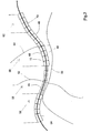
- Fig. 1 shows a schematic diagram of a section of a road map in Vector representation, as for example, in the memory of a computer unit a detection system according to the invention is present.
- Vector representation is then spoken when the road map is made up of coordinates exists, which are connected to the representation only with lines.
- the coordinates of Cards are saved in tables.
- suitable coordinate transformation so cutouts can be displayed in any size, without the Enlargement or reduction of losing information, as for example in a pixel graphic would be the case.
- An inventive detection system is used in particular to those To detect motor vehicles using toll roads.
- Other Applications exist, for example, in the police observation of certain vehicles.
- a detection system as Theft protection serve as the location and identification of the vehicle be sent continuously.
- a detection system basically also e.g. serve for traffic control and / or regulation.
- adjustable speed signs can be regulated to to prevent high traffic congestion.
- Satellite navigation system Global Positioning System
- the detection system has a suitable receiving and Processing device to the coordinate and identification signals to receive and process.
- the processing device consists of one or several computers that may be networked together.
- the digital map material i.a. offered by commercial providers becomes. In Fig. 1, therefore, a digital image of a map detail is thus shown quasi.
- a toll motorway is called, as a meandering Line is shown.
- ramps 12 and 14 lead out.
- Of the Highway 10 continues to drive exits 16, 18 away.
- On the highway 10 is further a service area 20, to exit 22 of the highway 10 leads.
- From the service area 20 A motor vehicle returns to Highway 10 via driveway 24. While it is at the highway 10 is a paid area, the rest area is a free space.
- the highway 10 is in suitable sections 26, 28, 30, 32 and 34 divided.
- the sections 26, 28, 30, 32, 34 of the highway 10 are perpendicular indicated by dashed lines. In these sections 26, 28, 30, 32, 34, or also Sections called, rectangle sectors 36, 38, 40, 42 and 44 over the course of Highway 10 is laid.
- the rectangular sectors 36, 38, 40, 42, 44 of each section 26, 28, 30, 32, 34 are in their length 46 and width 48 designed differently, in such a way that they are in suitably fit into the section 26, 28, 30, 32, 34. They will do that in theirs Length 46 and width 48 are each dimensioned for each section 26, 28, 30, 32, 34, that as few rectangular sectors 36, 38, 40, 42, 44 are used, so that as little memory of the computer is consumed.
- the rectangular sectors 36, However, 38, 40, 42, 44 of each section 26, 28, 30, 32, 34 are always the same large.
- the rest stop 20 - there must be the rectangular sectors 40 are relatively narrow designed (ie small width 48), so that the rectangular sectors 40 also do not overlap this area.
- Fig. 2 a similar situation is shown as in Fig. 1.
- the toll highway 10 lies at least in Partial areas very close to the highway 10.
- the highways 52, 54 cross the Highway 10.
- the toll highway 10 is in sections 56, 58, 60, 62 divided. Each of these sections 56, 58, 60, 62 has, analogous to FIG. 1, individual Rectangular sectors 64, 66, 68, 70 with suitable lengths 46 and 48 widths. In that area of the section 58, the rectangular sectors 66 are designed to be very narrow, so as not to Highway 50 to overlap.
- the highway 50 runs namely very close to the Highway 10. Otherwise, for a vehicle driving on Highway 50, may be charged fees, although this would not be necessary.
- the Billing is the same as described above for FIG.
- a vehicle 72 receives from a Satellite Navigation System 74 Data regarding its exact location. Via radio 76 the vehicle 72 transmits the position coordinates, arrow 78, and an individual one Identification signal, arrow 80. This position coordinates 78 and the Identification signal 80 are received by a receiving device 82 of a Detection system 84 received.
- the detection system is based on a geographical map 86 in vector representation (as shown in FIGS. 1 and 2 described) whether fees are due for the current position of the vehicle 72, Box 88. When fees are due, the account of the vehicle, which is due the identification signal 80 has been identified, road user charges have been assigned, Box 90. Subsequently, the holder of the vehicle can automatically an invoice be delivered, box 92.
Landscapes
- Engineering & Computer Science (AREA)
- Radar, Positioning & Navigation (AREA)
- Remote Sensing (AREA)
- General Physics & Mathematics (AREA)
- Physics & Mathematics (AREA)
- Computer Networks & Wireless Communication (AREA)
- Automation & Control Theory (AREA)
- Business, Economics & Management (AREA)
- Finance (AREA)
- Devices For Checking Fares Or Tickets At Control Points (AREA)
- Traffic Control Systems (AREA)
- Navigation (AREA)
- Position Fixing By Use Of Radio Waves (AREA)
- Sowing (AREA)
Description
- Fig. 1
- zeigt in einer Prinzipskizze einen Ausschnitt einer digitalen Straßenkarte in Vektordarstellung, mit einer gebührenpflichtigen Autobahn und gebührenfreier Raststätte.
- Fig. 2
- zeigt in einer Prinzipskizze einen Ausschnitt einer digitalen Straßenkarte in Vektordarstellung, mit einer gebührenpflichtigen Autobahn und gebührenfreier Landstraße.
- Fig.3
- zeigt die Funktionsweise eines erfindungsgemäßen Erfassungssystems.
Claims (24)
- Erfassungssystem (84) zum Erfassen von Fahrzeugen (72) mit einem Positionsbestimmungssystem (74), z.B. Satellitennavigations- oder Peilsystem, bei der Benutzung von Straßen (10); mit den Merkmalena) Mittel (76), mit denen ein Fahrzeug sein empfangenes Koordinatensignal (78) an das Erfassungssystem (84) übermittelt,b) wobei das Erfassungssystem (84) eine Rechnereinheit enthält;c) in einem Speicher der Rechnereinheit eine digitale Straßenkarte (86) vorliegt,d) wobei ausgewählte Straßen (10) der Straßenkarte (86) in geeignete Abschnitte (26, 28, 30,32,34) unterteilt sind;e) jeder Abschnitt (26, 28, 30,32,34) wiederum in digitale Rechtecksektoren (36, 38, 40, 42, 44) unterteilt ist,f) Mittel zum Zuordnen der Rechtecksektoren (36, 38, 40, 42, 44) den Koordinaten des jeweils erfaßten Fahrzeugs (72),g) jeder Abschnitt (26, 28, 30,32,34) jeweils eine geeignete Länge (46) der Rechtecksektoren (36, 38,40,42, 44) aufweist;h) die Rechtecksektoren (36, 38, 40, 42, 44) über der Straßenführung liegen,
dadurch gekennzeichnet, daßi) für jeden Abschnitt (26, 28, 30,32,34) jeweils eine geeignete Breite (48) der Rechtecksektoren (36, 38, 40, 42, 44) vorgesehen ist. - Erfassungssystem (84) zum Erfassen von Fahrzeugen (72) mit einem Positionsbestimmungssystem (74) bei der Benutzung von Straßen (10) nach Anspruch 1, dadurch gekennzeichnet, daß die Abschnitte (26, 28, 30, 32, 34) eine unterschiedliche Länge (46) aufweisen.
- Erfassungssystem (84) zum Erfassen von Fahrzeugen (72) mit einem Positionsbestimmungssystem (74) bei der Benutzung von Straßen (10) nach einem der Ansprüche 1 oder 2, dadurch gekennzeichnet, daß die ausgewählten Straßen gebührenpflichtige Straßen, wie z.B. Autobahnen (10), sind.
- Erfassungssystem (84) zum Erfassen von Fahrzeugen (72) mit einem Positionsbestimmungssystem (74) bei der Benutzung von Straßen (10) nach Anspruch 3, dadurch gekennzeichnet, daß die Abschnitte (26, 28, 30, 32, 34) von Ausfahrt (16, 18 ) zu Ausfahrt (16, 18) vorgesehen sind.
- Erfassungssystem (84) zum Erfassen von Fahrzeugen (72) mit einem Positionsbestimmungssystem (74) bei der Benutzung von Straßen (10) nach einem der Ansprüche 1 bis 4, dadurch gekennzeichnet, daß Mittel vorgesehen sind, die die Erfassung des Fahrzeugs (72) erst bei Eintritt des Koordinatensignals (78) in einen Rechtecksektor (36, 38, 40, 42, 44) aktiviert.
- Erfassungssystem (84) zum Erfassen von Fahrzeugen (72) mit einem Positionsbestimmungssystem (74) bei der Benutzung von Straßen (10) nach einem der Ansprüche 1 bis 5, dadurch gekennzeichnet, daß Mittel vorgesehen sind, die die Erfassung des Fahrzeugs (72) bei Austritt des Koordinatensignals (78) aus einem Rechtecksektor (36, 38, 40, 42, 44) deaktiviert.
- Erfassungssystem (84) zum Erfassen von Fahrzeugen (72) mit einem Positionsbestimmungssystem (74) bei der Benutzung von Straßen (10) nach einem der Ansprüche 1 bis 6, gekennzeichnet durch Identifizierungsmittel, welche ein Identifizierungssignal (80) zum eindeutigen Identifizieren eines erfaßten Fahrzeugs (72) an das Erfassungssystem (84) senden.
- Erfassungssystem (84) zum Erfassen von Fahrzeugen (72) mit einem Positionsbestimmungssystem (74) bei der Benutzung von Straßen (10) nach einem der Ansprüche 1 bis 7, dadurch gekennzeichnet, daß Mittel für eine Gebührenzuordnung (90) für die erfaßten Fahrzeuge (72) vorgesehen sind.
- Erfassungssystem (84) zum Erfassen von Fahrzeugen (72) mit einem Positionsbestimmungssystem (74) bei der Benutzung von Straßen (10) nach einem der Ansprüche 1 bis 8, dadurch gekennzeichnet, daß Mittel zum Ermitteln des Eintrittswinkels und/oder Austrittswinkels eines Fahrzeugs (72) in einen Rechtecksektor (36, 38, 40, 42, 44) vorgesehen sind.
- Erfassungssystem (84) zum Erfassen von Fahrzeugen (72) mit einem Positionsbestimmungssystem (74) bei der Benutzung von Straßen (10) nach einem der Ansprüche 1 bis 9, gekennzeichnet durch Mittel zum Optimieren bzw. Reduzieren der Datenmengen, insbesondere der Straßendaten, der Abschnittsdaten (26, 28, 30, 32, 34) und der Daten der Rechtecksektoren (36, 38, 40, 42, 44).
- Erfassungssystem (84) zum Erfassen von Fahrzeugen (72) mit einem Positionsbestimmungssystem (74) bei der Benutzung von Straßen (10) nach einem der Ansprüche 1 bis 10, dadurch gekennzeichnet, daß die digitale Straßenkarte (86) als Vektordaten vorliegt.
- Erfassungssystem (84) zum Erfassen von Fahrzeugen (72) mit einem Positionsbestimmungssystem (74) bei der Benutzung von Straßen (10) nach einem der Ansprüche 1 bis 11, dadurch gekennzeichnet, daß Mittel zum Festlegen eines Toleranzbereiches vorgesehen sind, in dem die Aktivierung bzw. Deaktivierung der Erfassung des Fahrzeugs (72) erfolgt.
- Verfahren zum Erfassen von Fahrzeugen mit einem Positionsbestimmungssystem (74), z.B. Satelitennavigationssystem (GPS), bei der Benutzung von Straßen (10), mit folgenden Verfahrensschritten:a) Übermitteln des empfangenen Koordinatensignals (78) an ein Erfassungssystem (84) mit einer Rechnereinheit, in dessen Speicher eine digitale Straßenkarte (86) vorliegt,b) Unterteilen ausgewählter Straßen (10) der Straßenkarte (86) in geeignete Abschnitte (26, 28, 30, 32, 34);e) Unterteilen eines jeden Abschnitts (26, 28, 30, 32, 34) wiederum in digitale Rechtecksektoren (36, 38, 40, 42, 44),f) Zuordnen der Rechtecksektoren (36, 38, 40, 42, 44) den Koordinaten (78) des jeweils erfaßten Fahrzeugs (72),g) jedem Abschnitt (26, 28, 30, 32, 34) jeweils eine geeignete Länge (46) für die Rechtecksektoren (36, 38, 40, 42, 44) zuordnen;h) Legen der Rechtecksektoren (36, 38, 40, 42, 44) über die Straßenführung (10),
dadurch gekennzeichnet, daßi) jedem Abschnitt (26, 28, 30, 32, 34) jeweils eine geeignete Breite (48) für die Rechtecksektoren (36, 38, 40, 42, 44) zugeordnet wird. - Verfahren zum Erfassen von Fahrzeugen (72) mit einem Positionsbestimmungssystem (74) bei der Benutzung von Straßen (10) nach Anspruch 13, dadurch gekennzeichnet, daß den Abschnitten (26, 28, 30, 32, 34) eine geeignete Länge zugeordnet wird, wobei die Längen unterschiedlich sein können.
- Verfahren zum Erfassen von Fahrzeugen (72) mit einem Positionsbestimmungssystem (74) bei der Benutzung von Straßen (10) nach einem der Ansprüche 13 oder 14, dadurch gekennzeichnet, daß gebührenpflichtige Straßen (10) als relevante Straßen ausgewählt werden.
- Verfahren zum Erfassen von Fahrzeugen (72) mit einem Positionsbestimmungssystem (74) bei der Benutzung von Straßen (10) nach Anspruch 15, dadurch gekennzeichnet, daß die Unterteilung der Straßen in Abschnitte (26, 28, 30, 32, 34) im Fall von Autobahnen oder autobahnähnlichen Straßen von Ausfahrt (16, 18) zu Ausfahrt (16, 18) vorgenommen wird.
- Verfahren zum Erfassen von Fahrzeugen (72) mit einem Positionsbestimmungssystem (74) bei der Benutzung von Straßen (10) nach einem der Ansprüche 13 bis 16, dadurch gekennzeichnet, daß die Erfassung des Fahrzeugs (72) erst bei Eintritt des Koordinatensignals (78) in einen Rechtecksektor (36, 38, 40, 42, 44) aktiviert wird.
- Verfahren zum Erfassen von Fahrzeugen (72) mit einem Positionsbestimmungssystem (74) bei der Benutzung von Straßen (10) nach einem der Ansprüche 13 bis 17, dadurch gekennzeichnet, daß die Erfassung des Fahrzeugs (72) bei Austritt des Koordinatensignals (78) aus einem Rechtecksektor. (36, 38, 40, 42, 44) deaktiviert wird.
- Verfahren zum Erfassen von Fahrzeugen (72) mit einem Positionsbestimmungssystem (74) bei der Benutzung von Straßen (10) nach einem der Ansprüche 13 bis 18, dadurch gekennzeichnet, daß ein Identifizierungssignal (80) zum eindeutigen Identifizieren eines erfaßten Fahrzeugs (72) an das Erfassungssystem (84) gesendet wird.
- Verfahren zum Erfassen von Fahrzeugen (72) mit einem Positionsbestimmungssystem (74) bei der Benutzung von Straßen (10) nach einem der Ansprüche 13 bis 19, dadurch gekennzeichnet, daß Gebühren einem erfaßten Fahrzeug (72) zugeordnet werden.
- Verfahren zum Erfassen von Fahrzeugen (72) mit einem Positionsbestimmungssystem (74) bei der Benutzung von Straßen (10) nach einem der Ansprüche 13 bis 20, dadurch gekennzeichnet, daß der Eintrittswinkel und/oder Austrittswinkel, mit denen ein Fahrzeug (72) in einen Rechtecksektor (36, 38, 40, 42, 44) ein- bzw. austritt, ermittelt wird.
- Verfahren zum Erfassen von Fahrzeugen (72) mit einem Positionsbestimmungssystem (74) bei der Benutzung von Straßen (10) nach einem der Ansprüche 13 bis 21, dadurch gekennzeichnet, daß eine Datenoptimierung bzw. Datenreduzierung, insbesondere der Straßendaten, der Abschnittsdaten und der Daten der Rechtecksektoren (36, 38, 40, 42, 44), erfolgt.
- Verfahren zum Erfassen von Fahrzeugen (72) mit einem Positionsbestimmungssystem (74) bei der Benutzung von Straßen (10) nach einem der Ansprüche 13 bis 22, dadurch gekennzeichnet, daß die digitale Straßenkarte (86) als Vektordaten im Speicher der Rechnereinheit abgespeichert wird.
- Verfahren zum Erfassen von Fahrzeugen (72) mit einem Positionsbestimmungssystem (74) bei der Benutzung von Straßen (10) nach einem der Ansprüche 13 bis 23, dadurch gekennzeichnet, daß ein Toleranzbereich festgelegt wird, in dem die Aktivierung bzw. Deaktivierung der Erfassung eines Fahrzeugs erfolgt.
Applications Claiming Priority (3)
| Application Number | Priority Date | Filing Date | Title |
|---|---|---|---|
| DE10149991A DE10149991A1 (de) | 2001-10-11 | 2001-10-11 | Erfassungssystem für Fahrzeuge mit GPS |
| DE10149991 | 2001-10-11 | ||
| PCT/EP2002/009090 WO2003034346A1 (de) | 2001-10-11 | 2002-08-21 | Erfassungssystem für fahrzeuge mit gps |
Publications (2)
| Publication Number | Publication Date |
|---|---|
| EP1436783A1 EP1436783A1 (de) | 2004-07-14 |
| EP1436783B1 true EP1436783B1 (de) | 2005-04-06 |
Family
ID=7702051
Family Applications (1)
| Application Number | Title | Priority Date | Filing Date |
|---|---|---|---|
| EP02764849A Expired - Lifetime EP1436783B1 (de) | 2001-10-11 | 2002-08-21 | Erfassungssystem für fahrzeuge mit gps |
Country Status (7)
| Country | Link |
|---|---|
| US (1) | US7006915B2 (de) |
| EP (1) | EP1436783B1 (de) |
| CN (1) | CN100430964C (de) |
| AT (1) | ATE292829T1 (de) |
| DE (2) | DE10149991A1 (de) |
| ES (1) | ES2240795T3 (de) |
| WO (1) | WO2003034346A1 (de) |
Cited By (1)
| Publication number | Priority date | Publication date | Assignee | Title |
|---|---|---|---|---|
| EP1710540B1 (de) * | 2005-04-07 | 2010-06-30 | Efkon Mobility GmbH | Verfahren zum Erkennen des Passierens eines vorgegebenen Ortes |
Families Citing this family (16)
| Publication number | Priority date | Publication date | Assignee | Title |
|---|---|---|---|---|
| AT414281B (de) * | 2002-09-12 | 2006-11-15 | Siemens Ag Oesterreich | Verfahren zur feststellung des befahrens zumindest eines mautpflichtigen strassenabschnitts |
| DE102004001906B4 (de) * | 2004-01-14 | 2013-09-05 | Daimler Ag | Verfahren und Computerprogramm zum Generieren von mindestens einem Datensatz als Repräsentation für einen Abschnitt einer gebührenpflichtigen Straße |
| DE102005008360A1 (de) * | 2005-02-23 | 2006-08-24 | Vodafone Holding Gmbh | Verfahren und System zur Ermittlung von Positionsdaten eines Objekts |
| DE102005008359A1 (de) * | 2005-02-23 | 2006-08-24 | Vodafone Holding Gmbh | Verfahren zum Erkennen der Position von Fahrzeugen und System zum Erkennen von Fahrzeugen in einem geographischen Bereich |
| DE102005011412A1 (de) | 2005-03-11 | 2006-09-14 | Vodafone Holding Gmbh | Verfahren und System zum Erfassen eines Objekts |
| DE102005018557A1 (de) * | 2005-04-20 | 2006-10-26 | T-Mobile International Ag & Co. Kg | Verfahren und Vorrichtung zur automatischen Rekonstruktion und Auswertung einer gefahrenen Strecke |
| DE102005029447A1 (de) * | 2005-06-24 | 2006-12-28 | Vodafone Holding Gmbh | Verfahren und Anordnung zum Bestimmen eines zurückgelegten Wegs eines Fahrzeugs |
| DE102005041068B4 (de) * | 2005-08-30 | 2007-06-06 | Siemens Ag | Prüfverfahren zur Erkennung von Abweichungen von Geoobjekten |
| DE102006027676A1 (de) * | 2006-06-14 | 2007-12-20 | Siemens Ag | Verfahren zur Fahrstreckenerkennung in einem Mautsystem |
| DE102007056250A1 (de) * | 2007-11-21 | 2009-05-28 | Deutsche Telekom Ag | Verfahren zur Erkennung mautpflichtiger Straßenabschnitte |
| FR2943448B1 (fr) * | 2009-03-20 | 2016-02-12 | Cs Systemes D Information | Procede et systeme de detection de vehicules terrestres sur un reseau routier et boitier de localisation par satellites pour le procede et le systeme |
| GB201010180D0 (en) * | 2010-06-17 | 2010-07-21 | Skymeter Corp | Tracking method |
| KR20120072124A (ko) * | 2010-12-23 | 2012-07-03 | 한국전자통신연구원 | 실내 전자지도 데이터 생성 방법 |
| CN102620743A (zh) * | 2011-12-31 | 2012-08-01 | 深圳市凯立德科技股份有限公司 | 一种规划路径的显示方法及装置 |
| CN105717939B (zh) * | 2016-01-20 | 2018-10-02 | 李万鸿 | 一种支持汽车无人自动驾驶的道路路面的信息化和网络化实施方法 |
| CN111681432B (zh) * | 2020-04-30 | 2022-03-29 | 大连理工大学 | 一种包含信号灯路口的拥堵源头确定方法及装置 |
Family Cites Families (14)
| Publication number | Priority date | Publication date | Assignee | Title |
|---|---|---|---|---|
| JP2536190B2 (ja) * | 1989-10-24 | 1996-09-18 | 三菱電機株式会社 | 移動体用ナビゲ―ション装置 |
| DE4039887A1 (de) * | 1990-12-13 | 1992-06-17 | Bosch Gmbh Robert | Fahrzeugleit- und zielfuehrungssystem |
| DE4310099C2 (de) * | 1993-03-23 | 1997-09-04 | Mannesmann Ag | Einrichtung zur Identifizierung von Wegstrecken |
| DE59407782D1 (de) * | 1993-11-26 | 1999-03-18 | Mannesmann Ag | Einrichtung in einem fahrzeug zur feststellung des betretens einer teilstrecke eines vorgegebenen strassennetzes |
| DE4402614A1 (de) * | 1994-01-28 | 1995-08-03 | Deutsche Telekom Mobil | Verfahren zur Ermittlung von Gebühren für die Nutzung von Verkehrswegen durch Fahrzeuge |
| JP3365050B2 (ja) * | 1994-06-16 | 2003-01-08 | トヨタ自動車株式会社 | 車両用情報伝達装置 |
| AUPN437395A0 (en) * | 1995-07-24 | 1995-08-17 | D & E Consulting Pty Ltd | System and method for determining the distance travelled by a vehicle |
| US5933100A (en) * | 1995-12-27 | 1999-08-03 | Mitsubishi Electric Information Technology Center America, Inc. | Automobile navigation system with dynamic traffic data |
| DE19615733A1 (de) * | 1996-04-20 | 1997-10-23 | Bosch Gmbh Robert | Verfahren zur automatischen Erhebung von Straßenbenutzungsgebühren |
| ATE237404T1 (de) | 1997-06-06 | 2003-05-15 | Robert Nyblad Gmbh | Verfahren und vorrichtung zur aufbereitung von material |
| DE19856184A1 (de) * | 1998-12-05 | 2000-06-08 | Alcatel Sa | Verfahren zur fahrzeuginternen Feststellung, ob sich das Fahrzeug auf einer von mehreren vorgegebenen Straßen befindet |
| US6479298B1 (en) | 1998-12-05 | 2002-11-12 | Becton, Dickinson And Company | Device and method for separating components of a fluid sample |
| JP4054484B2 (ja) * | 1999-06-30 | 2008-02-27 | 本田技研工業株式会社 | 移動体用地図情報表示システム |
| JP4068774B2 (ja) * | 1999-11-26 | 2008-03-26 | 本田技研工業株式会社 | 移動体用地図情報表示システム |
-
2001
- 2001-10-11 DE DE10149991A patent/DE10149991A1/de not_active Withdrawn
-
2002
- 2002-08-21 AT AT02764849T patent/ATE292829T1/de not_active IP Right Cessation
- 2002-08-21 WO PCT/EP2002/009090 patent/WO2003034346A1/de not_active Ceased
- 2002-08-21 CN CNB028200977A patent/CN100430964C/zh not_active Expired - Fee Related
- 2002-08-21 ES ES02764849T patent/ES2240795T3/es not_active Expired - Lifetime
- 2002-08-21 DE DE50202734T patent/DE50202734D1/de not_active Expired - Lifetime
- 2002-08-21 EP EP02764849A patent/EP1436783B1/de not_active Expired - Lifetime
-
2004
- 2004-04-09 US US10/822,552 patent/US7006915B2/en not_active Expired - Lifetime
Cited By (1)
| Publication number | Priority date | Publication date | Assignee | Title |
|---|---|---|---|---|
| EP1710540B1 (de) * | 2005-04-07 | 2010-06-30 | Efkon Mobility GmbH | Verfahren zum Erkennen des Passierens eines vorgegebenen Ortes |
Also Published As
| Publication number | Publication date |
|---|---|
| ES2240795T3 (es) | 2005-10-16 |
| ATE292829T1 (de) | 2005-04-15 |
| DE10149991A1 (de) | 2003-04-30 |
| WO2003034346A1 (de) | 2003-04-24 |
| US20040260462A1 (en) | 2004-12-23 |
| CN100430964C (zh) | 2008-11-05 |
| EP1436783A1 (de) | 2004-07-14 |
| CN1592918A (zh) | 2005-03-09 |
| US7006915B2 (en) | 2006-02-28 |
| DE50202734D1 (de) | 2005-05-12 |
Similar Documents
| Publication | Publication Date | Title |
|---|---|---|
| DE60201075T2 (de) | Verkehrsleitsystem mit vom verstopfungsgrad der strassen abhängenden strassenbenutzungsgebühren | |
| EP2909815B1 (de) | Verfahren und einrichtungen zur verkehrsbedingten mauterhebung | |
| EP1449174B1 (de) | Erfassungssystem für flächige bereiche zum erfassen von fahrzeugen mit gps | |
| DE19912859B4 (de) | Kommunikationsfähiges Navigationssystem | |
| DE19606258C1 (de) | Fahrzeugautonome Detektion von Verkehrsstau | |
| EP1436783A1 (de) | Erfassungssystem für fahrzeuge mit gps | |
| EP0730726B1 (de) | Verfahren zur erzeugung einer digitalisierten strassennetzkarte | |
| EP0941534B1 (de) | Verfahren zur ermittlung von fahrtroutendaten | |
| EP2817786A1 (de) | Buchungs- und stornierungsverfahren sowie gebührenerhebungsverfahren in einem gebührenerhebungssystem | |
| EP1814095B1 (de) | Verfahren zur Bestimmung eines zukünftigen Strassenverlaufs durch Kommunikation zwischen Kraftfahrzeugen | |
| DE19740602B4 (de) | Verkehrsleit-, Informations- und Positionierungssystem (VIPS) | |
| EP2431712B1 (de) | Verfahren zum Ermitteln der Länge des von einem Fahrzeug zurückgelegten Wegs | |
| DE102018108538A1 (de) | Verfahren zur Ermittlung von Verkehrsinformationen | |
| EP0802509A2 (de) | Verfahren zur automatischen Erhebung von Strassenbenutzungsgebühren | |
| EP1475752A2 (de) | Verfahren und System zur elektronischen Erhebung von Nutzungsgebühren | |
| EP1696208B1 (de) | Verfahren zum Erkennen der Position von Fahrzeugen und System zum Erkennen von Fahrzeugen in einem geographischen Bereich | |
| DE102009042470A1 (de) | Anordnung und Verfahren zur Erfassung von Gebühren auf mautpflichtigen Straßen | |
| DE112006003643B4 (de) | Routensuchsystem | |
| EP1736932A1 (de) | Verfahren und Anordung zum Bestimmen eines zurückgelegten Wegs eines Fahrzeugs | |
| EP1657683A2 (de) | Verfahren und System zum Erfassen eines Fahrzeugs | |
| DE10052109B4 (de) | Verfahren zum Beschreiben und Erzeugen von Straßennetzen und Straßennetz | |
| DE69617562T2 (de) | Zielführungsvorrichtung für ringautobahn | |
| EP3346451B1 (de) | Verfahren zur verfolgung mautpflichtiger fahrzeuge in einem mautsystem und entsprechendes mautsystem | |
| DE102005022702A1 (de) | Verfahren zur Erhebung von Straßenbenutzungs-Gebühren in Verbindung mit Zielführung | |
| DE102005049768A1 (de) | Mauterfassungsgerät und Mauterfassungsverfahren |
Legal Events
| Date | Code | Title | Description |
|---|---|---|---|
| PUAI | Public reference made under article 153(3) epc to a published international application that has entered the european phase |
Free format text: ORIGINAL CODE: 0009012 |
|
| 17P | Request for examination filed |
Effective date: 20040511 |
|
| AK | Designated contracting states |
Kind code of ref document: A1 Designated state(s): AT BE BG CH CY CZ DE DK EE ES FI FR GB GR IE IT LI LU MC NL PT SE SK TR |
|
| AX | Request for extension of the european patent |
Extension state: AL LT LV MK RO SI |
|
| GRAP | Despatch of communication of intention to grant a patent |
Free format text: ORIGINAL CODE: EPIDOSNIGR1 |
|
| RAP1 | Party data changed (applicant data changed or rights of an application transferred) |
Owner name: VODAFONE HOLDING GMBH |
|
| GRAS | Grant fee paid |
Free format text: ORIGINAL CODE: EPIDOSNIGR3 |
|
| GRAA | (expected) grant |
Free format text: ORIGINAL CODE: 0009210 |
|
| AK | Designated contracting states |
Kind code of ref document: B1 Designated state(s): AT BE BG CH CY CZ DE DK EE ES FI FR GB GR IE IT LI LU MC NL PT SE SK TR |
|
| PG25 | Lapsed in a contracting state [announced via postgrant information from national office to epo] |
Ref country code: TR Free format text: LAPSE BECAUSE OF FAILURE TO SUBMIT A TRANSLATION OF THE DESCRIPTION OR TO PAY THE FEE WITHIN THE PRESCRIBED TIME-LIMIT Effective date: 20050406 Ref country code: SK Free format text: LAPSE BECAUSE OF FAILURE TO SUBMIT A TRANSLATION OF THE DESCRIPTION OR TO PAY THE FEE WITHIN THE PRESCRIBED TIME-LIMIT Effective date: 20050406 Ref country code: IE Free format text: LAPSE BECAUSE OF FAILURE TO SUBMIT A TRANSLATION OF THE DESCRIPTION OR TO PAY THE FEE WITHIN THE PRESCRIBED TIME-LIMIT Effective date: 20050406 Ref country code: FI Free format text: LAPSE BECAUSE OF FAILURE TO SUBMIT A TRANSLATION OF THE DESCRIPTION OR TO PAY THE FEE WITHIN THE PRESCRIBED TIME-LIMIT Effective date: 20050406 Ref country code: EE Free format text: LAPSE BECAUSE OF FAILURE TO SUBMIT A TRANSLATION OF THE DESCRIPTION OR TO PAY THE FEE WITHIN THE PRESCRIBED TIME-LIMIT Effective date: 20050406 |
|
| REG | Reference to a national code |
Ref country code: GB Ref legal event code: FG4D Free format text: NOT ENGLISH |
|
| REG | Reference to a national code |
Ref country code: CH Ref legal event code: EP |
|
| REG | Reference to a national code |
Ref country code: IE Ref legal event code: FG4D Free format text: LANGUAGE OF EP DOCUMENT: GERMAN |
|
| REF | Corresponds to: |
Ref document number: 50202734 Country of ref document: DE Date of ref document: 20050512 Kind code of ref document: P |
|
| REG | Reference to a national code |
Ref country code: CH Ref legal event code: NV Representative=s name: TROESCH SCHEIDEGGER WERNER AG |
|
| PG25 | Lapsed in a contracting state [announced via postgrant information from national office to epo] |
Ref country code: GR Free format text: LAPSE BECAUSE OF FAILURE TO SUBMIT A TRANSLATION OF THE DESCRIPTION OR TO PAY THE FEE WITHIN THE PRESCRIBED TIME-LIMIT Effective date: 20050706 Ref country code: BG Free format text: LAPSE BECAUSE OF FAILURE TO SUBMIT A TRANSLATION OF THE DESCRIPTION OR TO PAY THE FEE WITHIN THE PRESCRIBED TIME-LIMIT Effective date: 20050706 Ref country code: DK Free format text: LAPSE BECAUSE OF FAILURE TO SUBMIT A TRANSLATION OF THE DESCRIPTION OR TO PAY THE FEE WITHIN THE PRESCRIBED TIME-LIMIT Effective date: 20050706 Ref country code: SE Free format text: LAPSE BECAUSE OF FAILURE TO SUBMIT A TRANSLATION OF THE DESCRIPTION OR TO PAY THE FEE WITHIN THE PRESCRIBED TIME-LIMIT Effective date: 20050706 |
|
| PG25 | Lapsed in a contracting state [announced via postgrant information from national office to epo] |
Ref country code: LU Free format text: LAPSE BECAUSE OF NON-PAYMENT OF DUE FEES Effective date: 20050821 Ref country code: CY Free format text: LAPSE BECAUSE OF FAILURE TO SUBMIT A TRANSLATION OF THE DESCRIPTION OR TO PAY THE FEE WITHIN THE PRESCRIBED TIME-LIMIT Effective date: 20050821 Ref country code: AT Free format text: LAPSE BECAUSE OF NON-PAYMENT OF DUE FEES Effective date: 20050821 |
|
| PG25 | Lapsed in a contracting state [announced via postgrant information from national office to epo] |
Ref country code: MC Free format text: LAPSE BECAUSE OF NON-PAYMENT OF DUE FEES Effective date: 20050831 Ref country code: BE Free format text: LAPSE BECAUSE OF NON-PAYMENT OF DUE FEES Effective date: 20050831 |
|
| PG25 | Lapsed in a contracting state [announced via postgrant information from national office to epo] |
Ref country code: PT Free format text: LAPSE BECAUSE OF FAILURE TO SUBMIT A TRANSLATION OF THE DESCRIPTION OR TO PAY THE FEE WITHIN THE PRESCRIBED TIME-LIMIT Effective date: 20050908 |
|
| GBT | Gb: translation of ep patent filed (gb section 77(6)(a)/1977) |
Effective date: 20050818 |
|
| REG | Reference to a national code |
Ref country code: ES Ref legal event code: FG2A Ref document number: 2240795 Country of ref document: ES Kind code of ref document: T3 |
|
| REG | Reference to a national code |
Ref country code: IE Ref legal event code: FD4D |
|
| ET | Fr: translation filed | ||
| PLBE | No opposition filed within time limit |
Free format text: ORIGINAL CODE: 0009261 |
|
| STAA | Information on the status of an ep patent application or granted ep patent |
Free format text: STATUS: NO OPPOSITION FILED WITHIN TIME LIMIT |
|
| 26N | No opposition filed |
Effective date: 20060110 |
|
| BERE | Be: lapsed |
Owner name: VODAFONE HOLDING G.M.B.H. Effective date: 20050831 |
|
| REG | Reference to a national code |
Ref country code: CH Ref legal event code: PUE Owner name: VODAFONE IP LICENSING LIMITED, GB Free format text: FORMER OWNER: VODAFONE HOLDING GMBH, DE Ref country code: CH Ref legal event code: NV Representative=s name: E. BLUM AND CO. AG PATENT- UND MARKENANWAELTE , CH Ref country code: CH Ref legal event code: PUE Owner name: KAPSCH TRAFFICCOM AG, AT Free format text: FORMER OWNER: VODAFONE IP LICENSING LIMITED, GB |
|
| REG | Reference to a national code |
Ref country code: ES Ref legal event code: PC2A Owner name: KAPSCH TRAFICCOM AG Effective date: 20130128 Ref country code: ES Ref legal event code: PC2A Owner name: KAPSCH TRAFFICCOM AG Effective date: 20130129 |
|
| REG | Reference to a national code |
Ref country code: FR Ref legal event code: TP Owner name: KAPSCH TRAFFICCOM AG, AT Effective date: 20130130 |
|
| REG | Reference to a national code |
Ref country code: NL Ref legal event code: SD Effective date: 20130227 |
|
| REG | Reference to a national code |
Ref country code: DE Ref legal event code: R082 Ref document number: 50202734 Country of ref document: DE Representative=s name: MEISSNER & MEISSNER, DE Effective date: 20130215 Ref country code: DE Ref legal event code: R081 Ref document number: 50202734 Country of ref document: DE Owner name: KAPSCH TRAFFICCOM AG, AT Free format text: FORMER OWNER: VODAFONE HOLDING GMBH, 40213 DUESSELDORF, DE Effective date: 20130215 Ref country code: DE Ref legal event code: R081 Ref document number: 50202734 Country of ref document: DE Owner name: KAPSCH TRAFFICCOM AG, AT Free format text: FORMER OWNER: VODAFONE HOLDING GMBH, 40549 DUESSELDORF, DE Effective date: 20130215 Ref country code: DE Ref legal event code: R082 Ref document number: 50202734 Country of ref document: DE Representative=s name: ANWALTSKANZLEI MEISSNER & MEISSNER, DE Effective date: 20130215 |
|
| REG | Reference to a national code |
Ref country code: GB Ref legal event code: 732E Free format text: REGISTERED BETWEEN 20130411 AND 20130417 |
|
| REG | Reference to a national code |
Ref country code: FR Ref legal event code: PLFP Year of fee payment: 15 |
|
| PGFP | Annual fee paid to national office [announced via postgrant information from national office to epo] |
Ref country code: NL Payment date: 20160819 Year of fee payment: 15 |
|
| PGFP | Annual fee paid to national office [announced via postgrant information from national office to epo] |
Ref country code: IT Payment date: 20160825 Year of fee payment: 15 Ref country code: CH Payment date: 20160819 Year of fee payment: 15 Ref country code: GB Payment date: 20160819 Year of fee payment: 15 |
|
| PGFP | Annual fee paid to national office [announced via postgrant information from national office to epo] |
Ref country code: CZ Payment date: 20160819 Year of fee payment: 15 |
|
| REG | Reference to a national code |
Ref country code: FR Ref legal event code: PLFP Year of fee payment: 16 |
|
| REG | Reference to a national code |
Ref country code: CH Ref legal event code: PL |
|
| REG | Reference to a national code |
Ref country code: NL Ref legal event code: MM Effective date: 20170901 |
|
| GBPC | Gb: european patent ceased through non-payment of renewal fee |
Effective date: 20170821 |
|
| PG25 | Lapsed in a contracting state [announced via postgrant information from national office to epo] |
Ref country code: CH Free format text: LAPSE BECAUSE OF NON-PAYMENT OF DUE FEES Effective date: 20170831 Ref country code: LI Free format text: LAPSE BECAUSE OF NON-PAYMENT OF DUE FEES Effective date: 20170831 Ref country code: CZ Free format text: LAPSE BECAUSE OF NON-PAYMENT OF DUE FEES Effective date: 20170821 |
|
| PG25 | Lapsed in a contracting state [announced via postgrant information from national office to epo] |
Ref country code: NL Free format text: LAPSE BECAUSE OF NON-PAYMENT OF DUE FEES Effective date: 20170901 |
|
| PG25 | Lapsed in a contracting state [announced via postgrant information from national office to epo] |
Ref country code: GB Free format text: LAPSE BECAUSE OF NON-PAYMENT OF DUE FEES Effective date: 20170821 |
|
| REG | Reference to a national code |
Ref country code: FR Ref legal event code: PLFP Year of fee payment: 17 |
|
| PG25 | Lapsed in a contracting state [announced via postgrant information from national office to epo] |
Ref country code: IT Free format text: LAPSE BECAUSE OF NON-PAYMENT OF DUE FEES Effective date: 20170821 |
|
| PGFP | Annual fee paid to national office [announced via postgrant information from national office to epo] |
Ref country code: FR Payment date: 20210819 Year of fee payment: 20 |
|
| PGFP | Annual fee paid to national office [announced via postgrant information from national office to epo] |
Ref country code: DE Payment date: 20210819 Year of fee payment: 20 |
|
| PGFP | Annual fee paid to national office [announced via postgrant information from national office to epo] |
Ref country code: ES Payment date: 20211025 Year of fee payment: 20 |
|
| REG | Reference to a national code |
Ref country code: DE Ref legal event code: R071 Ref document number: 50202734 Country of ref document: DE |
|
| REG | Reference to a national code |
Ref country code: ES Ref legal event code: FD2A Effective date: 20220829 |
|
| PG25 | Lapsed in a contracting state [announced via postgrant information from national office to epo] |
Ref country code: ES Free format text: LAPSE BECAUSE OF EXPIRATION OF PROTECTION Effective date: 20220822 |