EP1249685A2 - Gerät und Verfahren zur Bereitstellung von Strassenkartendaten für einen beweglichen Körper - Google Patents
Gerät und Verfahren zur Bereitstellung von Strassenkartendaten für einen beweglichen Körper Download PDFInfo
- Publication number
- EP1249685A2 EP1249685A2 EP02005891A EP02005891A EP1249685A2 EP 1249685 A2 EP1249685 A2 EP 1249685A2 EP 02005891 A EP02005891 A EP 02005891A EP 02005891 A EP02005891 A EP 02005891A EP 1249685 A2 EP1249685 A2 EP 1249685A2
- Authority
- EP
- European Patent Office
- Prior art keywords
- road map
- map data
- delivery
- delivered
- movable body
- Prior art date
- Legal status (The legal status is an assumption and is not a legal conclusion. Google has not performed a legal analysis and makes no representation as to the accuracy of the status listed.)
- Withdrawn
Links
- 238000000034 method Methods 0.000 title claims description 64
- 238000012384 transportation and delivery Methods 0.000 claims description 190
- 230000004044 response Effects 0.000 claims description 11
- 239000000284 extract Substances 0.000 claims description 2
- 230000001419 dependent effect Effects 0.000 abstract 1
- 230000006854 communication Effects 0.000 description 40
- 238000004891 communication Methods 0.000 description 40
- 230000007175 bidirectional communication Effects 0.000 description 3
- 238000010586 diagram Methods 0.000 description 3
- 230000006870 function Effects 0.000 description 3
- 230000005540 biological transmission Effects 0.000 description 1
- 238000012790 confirmation Methods 0.000 description 1
- 239000004973 liquid crystal related substance Substances 0.000 description 1
Images




Classifications
-
- G—PHYSICS
- G01—MEASURING; TESTING
- G01C—MEASURING DISTANCES, LEVELS OR BEARINGS; SURVEYING; NAVIGATION; GYROSCOPIC INSTRUMENTS; PHOTOGRAMMETRY OR VIDEOGRAMMETRY
- G01C21/00—Navigation; Navigational instruments not provided for in groups G01C1/00 - G01C19/00
- G01C21/26—Navigation; Navigational instruments not provided for in groups G01C1/00 - G01C19/00 specially adapted for navigation in a road network
- G01C21/34—Route searching; Route guidance
- G01C21/36—Input/output arrangements for on-board computers
- G01C21/3667—Display of a road map
Definitions
- the present invention relates to apparatus and method for delivering a road map data into any one of movable bodies from which a request to deliver the road map data is issued with a function of a charging process executed for the delivery of the road map data.
- a road map data (also called, a geographical data) is displayed through a display unit installed within a vehicular passenger compartment to guide the vehicle to be traveled to a desired destination.
- a position and a direction of the vehicle which, in general, are detected using a GPS (Global Positioning System), a vehicle speed sensor, and a directional sensor are superimposed on the road map data read from a recording medium such as a CD-ROM or a DVD-ROM and displayed on the display unit.
- the road map data previously stored in the record medium such as the CD-ROM or the DVD-ROM is displayed on a display screen of the display unit, in such a navigation system as described above, the road map data which is displayed on the display screen of the display unit becomes different from an actual road situation in a case, for example, where a new road has been opened to a traffic and/or a new building or facility has been built.
- a, so-called, communication type navigation system has been proposed in which a wireless telecommunication device such as a transceiver is equipped in the vehicle and a latest road map data is downloaded from a road map data delivery device which provides a delivering service on the road map data via a communication device which is enabled to be communicated in a bi-directional communication and the downloaded road map data is displayed on the display screen of the display unit.
- a wireless telecommunication device such as a transceiver is equipped in the vehicle and a latest road map data is downloaded from a road map data delivery device which provides a delivering service on the road map data via a communication device which is enabled to be communicated in a bi-directional communication and the downloaded road map data is displayed on the display screen of the display unit.
- a predetermined charging process is, ordinarily, implemented to the delivery of the road map data from the road map data delivery device.
- Methods of implementing the predetermined charging process include a method of charging an amount of money to a user of the navigation system in accordance with a quantity of the road map data for each of the road map data deliveries and a method of charging a constant amount of money per predetermined period of time for the road map delivery service regardless of the quantity of data delivered.
- the quantity of the road map data to be delivered is small, it is advantageous for the user to adopt the former method of charging the amount of money in accordance with the quantity of data for the delivery of the road map data.
- a limited area road map data such that, with a present position of the vehicle as a center, a surrounding area to the present position is partitioned by a specified size is, ordinarily, delivered from the road map data delivery device.
- the limited area road map data from a point of place A to a destination is to be delivered, as shown in Fig. 12. If the deliver of the road map data at the point of place A is requested from the above-described communication type navigation system, the limited area road map data of an area ⁇ is delivered.
- the delivery of the road map data may be requested at a time point at which the vehicle has moved to a point of place B so as to acquire the limited area road map data of an area ⁇ with point of place B as a center.
- the vehicle needs to be moved with no presence of the road map data during a run of the vehicle from point of place A to point of place B. This gives an anxious feeling to a vehicle driver (viz., the user).
- the user largely dissatisfies with the charge for the delivery of the mesh data of the same area by the same amount of money in spite of the fact that the mesh data of the same area has been delivered.
- an object of the present invention to provide apparatus and method for delivering road map data which give a high convenience for the user by carrying out an appropriate charging process in accordance with a utility value of the road map data.
- a road map data delivering apparatus comprising: a road map data storing section in which a plurality of road map data are stored; a road map data delivering section that, in response to a request to deliver the road map data to a movable body issued from the same movable body, retrieves one of the road map data which corresponds to the delivery requested road map data and delivers the retrieved road map data to the same movable body; a delivery history storing section in which a delivery history of each road map data through the road map data delivering section is stored; and a charging process section that executes a charging process for the delivery of the road map data carried out by the road map data delivering section in such a manner as to refer to the delivery history of the delivered road map data stored in the delivery history storing section and to charge an amount of money discounted from a predetermined amount of money at a rate of discount varied in accordance with a degree of an overlap in a case where the road map data presently delivered to the road map data delivery requested
- a road map data delivering method comprising: storing a plurality of road map data; in response to a request to deliver the road map data to a movable body issued from the same movable body, retrieving one of the road map data which corresponds to the delivery requested road map data; delivering the retrieved road map data to the same movable body; storing a delivery history of each road map data delivered in a delivery history storing section; and executing a charging process for the delivery of the road map data in such a manner as to refer to the delivery history of the delivered road map data and to charge an amount of money discounted from a predetermined amount of money at a rate of discount varied in accordance with a degree of an overlap in a case where the road map data presently delivered to the road map data delivery requested movable body includes a portion on which the road map data delivered to the same movable body in the past is overlapped.
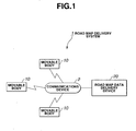
- Fig. 1 is a schematic block diagram of a rough configuration of a road map data delivery system to which a road map data delivering apparatus according to the present invention is applicable.
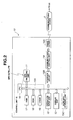
- Fig. 2 is a block diagram representing a configuration of a typical one of movable bodies shown in Fig. 1.
- Fig. 3 is a block diagram of a road map data delivery device shown in Fig. 1 to which the road map data delivering apparatus according to the present invention is applicable.
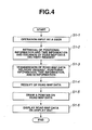
- Fig. 4 is a flowchart representing an example of a processing flow executed at any one of movable bodies of the road map delivery system shown in Fig. 1.
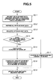
- Fig. 5 is a flowchart representing an example of a processing flow executed at the road map data delivery device of the road map data delivery system shown in Fig. 1.
- Fig. 6 is an explanatory top view of a road map data which is delivered to any one of movable bodies by the road map data delivering apparatus according to the present invention and on which a pointer indicating a present position of a road map data delivery requested movable body is drawn.
- Fig. 7 is an explanatory view representing an example of a method for calculating a degree of an overlap between the road map data delivered at the present time (lately delivered road map data) and that delivered in the past (previously delivered road map data).
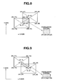
- Fig. 8 is an explanatory view representing the example of the method for calculating the degree of the overlap between the road map data delivered at the present time and that delivered in the past.
- Fig. 9 is an explanatory view representing the example of the method for calculating a degree of an overlap between the road map data delivered at the present time and that delivered in the past.
- Fig. 10 is an explanatory view representing the example of the method for calculating the degree of the overlap between the road map data delivered at the present time and that delivered in the past.
- Fig. 11 is an explanatory view representing another example of the method for calculating the degree of an overlap between the road map data delivered at the present time and that delivered in the past.
- Fig. 12 is an explanatory view for explaining an example of a case wherein the road map data delivered at the present time is overlapped partially on that delivered in the past when the road map data divided with a specified size of an area surrounding a present position of any one of the movable bodies with the present position as a center.
- Fig. 13 is an explanatory view for explaining another example of a case wherein the delivered road map data in a case where the road map data is delivered as a mesh data is overlapped partially on that delivered in the past.
- a road map data delivering apparatus serves to deliver a road map data (geographical data) to a movable body in response to a request to send the road map data from the movable body such as an on-vehicle navigation system, a handy phone, or a portable personal computer and to implement a charging process (or called, billing or accounting process) for the delivery of the road map data.
- Fig. 1 shows a rough configuration of a road map data delivery system 1 to which the road map delivery apparatus according to the present invention is applicable.
- a plurality of movable bodies 10 are connected wirelessly to a wireless communications device 2 which can enable road map data delivery system 1 shown in Fig. 1 to implement bi-directional communications between the respective movable bodies 10 and a road map data delivery device 20 to which the road map data delivering apparatus according to the present invention is applicable.
- Each movable body 10 includes an on-vehicle navigation system with a capability of wireless bi-directional communications, a personal handy phone system terminal, a portable personal computer (or called, portable terminal), and so forth.
- a message representing a request of a delivery of a road map data from any one or more of the movable bodies 10 is transmitted via communications device 2 to road map data delivery device 20 so that the road map data from road map data delivery device 20 is transmitted to the road map data delivery requested movable body 10 via communications device 2.
- Each movable body 10 includes a GPS (Global Positioning System) receiving unit 11 to receive a GPS signal from any one of a plurality of GPS satellites, an operation input unit 12 which outputs a series of signals indicating an operation input information according to its operation by the user, a display unit 13 which displays various kinds of information including the road map data delivered from road map delivery device 20, a communication control unit 14 which controls communications between each movable body 10 and the road map delivery device 20 and which is connected to a transceiver 14A or equivalent thereof to communicate wirelessly with communications unit 2; and a control unit 15 which controls the whole operation of the corresponding movable body 10.
- GPS Global Positioning System
- GPS receiving unit 11 receives GPS signal from any one of GPS satellites to retrieve a positional information representing a present position of the corresponding movable body 10 and a time information representing a present time and supplies the positional and time information to control unit 15.
- Operation input unit 12 includes various key buttons and supplies the output signals thereof in accordance with user button operated inputs to control unit 15. It is noted that operation unit 12 may integrally be constructed with display unit 13 in a form of a touch panel type operation input unit.
- Display unit 13 is constituted by, for example, a liquid crystal display panel and serves to display various kinds of information including road map data delivered from road map data delivery device 20 via communications unit 2 under a control by means of control unit 15.
- Communication control unit 14 transmits the information related to the request of the delivery of the road map data from the corresponding movable body 10 and the information related to movable body 10 via communications device 2 to road map data delivery device 20.
- communication control unit 14 receives the information such as the road map data from road map data delivery device 20 via transceiver 14A (antenna inclusive) and communications device 2.
- Control unit 15 includes a CPU (Central Processing Unit) 16, RAM (Random Access Memory) 17, a ROM (Read Only Memory) 18, a common bus 15A, and a V-RAM (Video-Random Access Memory) 19.
- CPU 16 utilizes RAM 17 as a work area, executes an operation program stored in ROM 18 to control the whole operation of the corresponding movable body 10.
- an auxiliary storage unit 15C such as a record medium (for example, CD-ROM or DVD-ROM) is connected to common bus 15A.
- auxiliary storage unit 15C may be omitted from each movable body 10 when each movable body 10 is exclusively used in a wireless communication system (viz., road map data delivery system 1) shown in Fig. 1.
- Communication control unit 14 is connected to control unit 15 via an interface circuit 15B.
- control unit 15 in each movable body 10 issues the request to deliver the road map data in accordance with operation inputs by the user through operation input unit 12, acquires various kinds of information on the corresponding movable body 10 such as the positional information and time information supplied from GPS receiving unit 11, and implements the control for the transmission of the road map data delivery request and various kinds of information related to the corresponding movable body 10 from communication control unit 14 to road map data delivery device 20 via communications device 2.
- control unit 15 receives the road map data delivered road map data delivery device 20 via communications device 2 in response to the request to deliver a desired road map data through communication control unit 14 and performs the control such that a pointer (an arrowed mark) representing a position of the corresponding movable body 10 is superimposed on the road map data and the superimposed road map data is displayed on a display screen of display unit 13.
- road map data delivery device 20 includes: a road map database 21 in which the plurality of road map data are stored; a delivery history storage unit 22 in which delivery histories of the individual road map data to movable bodies 10 are stored; a charge (account) table storage unit 23 in which a charge (or account) table representing a bill is stored for each user; a communication control unit 24 which controls the communications between the road map delivery device 20 itself and each movable body 10; and a control unit 25 which controls the whole operation of the road map data delivery device 20.
- Road map database 21 stores all regional road map data to be an object for a road map data delivery service.
- control unit 25 specifies the positional coordinates and the size of the road map data
- the road map data of the area surrounding the specified positional coordinates which indicate the center of the area of the road map data can be retrieved by the specified size from road map database 21. It is noted that the road map data stored in the road map database 21 are regularly updated so as to always be stored as latest road map data therein.
- Delivery history storage unit 22 stores delivery histories of the individual road map data delivered to the individual movable bodies 10 from road map data delivery device 20. It is noted that each delivery history of the road map data includes an information such as an individual ID information allocated to each movable body 10, the positional information and the time information when the request of delivery of the corresponding road map data is issued, and an information on the size (coordinates on four corners of the road map data) of the delivered road map data to the road map data delivery requested movable body 10. That is to say, in road map data delivery device 20, control unit 25 refers to the delivery histories of the road map data stored in delivery history storage unit 22 so as to be enabled to be recognized that what contents of the road map data were delivered in the past time to the corresponding (road map delivery requested) movable body 10.
- any old history data whose stored time indicates an elapse of time for a predetermined interval of time (for example, one month) from a time at which the corresponding history data is stored in the delivery history storage unit 22 from among the delivered histories of the road map data stored therein is deleted (disposed of) from delivery history storage unit 22.
- Account table storage unit 23 stores charge (account) tables requesting the users of respective movable bodies 10 to be paid by compensation for the delivery of the road map data. That is to say, in the road map data delivery device 20, when the road map data including a portion thereof on which the road map which was delivered in the past is overlapped is delivered, the charging process is carried out such that an amount of money which is discounted from a predetermined amount of money at a rate of discount varied in accordance with a degree of the overlap of the portion described above on the delivered road map previously delivered (delivered in the past) is charged for the delivery of the road map data described above.
- Account table storage unit 23 stores each charge table indicating a correspondent relationship between the degree of overlap on the road map data and the amount of money discounted at the rate of discount varied in accordance with the degree of the overlap.
- Communication control unit (abbreviated as CCU) 24 receives the delivery request of the road map data from any one of movable bodies 10 and the information related to any one of movable bodies 10 from the corresponding movable body 10 under a control by means of control unit 25 via communications device 2.
- Control unit 25 includes CPU 26, RAM 27, ROM 28, V-RAM 29, common bus 31, and an interface circuit 30, as shown in Fig. 3.
- CPU 26 utilizes RAM 27 as a work area and executes an operation program stored in ROM 28 to control a whole operation of road map data delivery device 20.
- control unit 25 retrieves one of road map data from road map database 21 in response to the request to deliver the same road map data issued from any one of movable bodies 10.
- control unit 25 retrieves the road map data of a desired area with a desired size on the basis of the positional coordinates of the corresponding movable body 10 and a requested size of the road map data.
- Control unit 25 performs such a control that the retrieved road map data is transmitted to the road map delivery requested one of movable bodies 10 via communications device 2. That is to say, in road map data delivery device 20, control unit 25 has a function as road map data delivering means for retrieving the corresponding road map data in response to the road map data delivery request issued by the road map data delivery requested movable body 10 from road map database 21 and for delivering the retrieved road map data to the road map delivery requested movable body 10.
- control unit 25 delivers the road map data in response to the road map delivery request from any one of movable bodies 10, thereafter, refers to the delivery history of the corresponding road map data to be delivered stored in delivery history storage unit 22, and determines whether the road map data delivered lately, at the present time, to the corresponding one of movable bodies 10 includes the portion of the overlap on that delivered in the past to the same movable body 10. At this time, the determination of whether the lately delivered road map data includes the overlapped portion is carried out with the road map data of the same size as an object to be determined.
- control unit 25 extracts one of the delivery histories of previously delivered road map data of the same size as the presently delivered road map data from among the delivery histories of road map data stored in delivery history storage unit 22 and determines whether the presently delivered road map data includes the overlapped portion of the road map data delivered in the past on the basis of the extracted delivery history.
- control unit 25 calculates a degree of the overlap (a magnitude of an area of the overlapped portion) as will be described later, refers to the charge table stored in the account table storage unit 23, derives the amount of money at a rate of discount varied in accordance with the degree of the overlap, and carries out the charging process to charge the discounted amount of money for the delivery of the road map data. That is to say, control unit 25 in road map data delivery device 20 has a function as a charging process section that charges the amount of money for the delivery of the road map data.
- a factor of a cause of such continual requests as described above may be considered to be a case where the user of the corresponding one of movable bodies 10 erroneously maneuvers operation inputs on operation input unit 12 or a case where the size of the first requested road map data is made different from that of the user desired size. Since, even in such cases as described above, the same charging process is performed by control unit 25 so that an excessive economical burden is improved on each user of movable bodies 10, it is desirable not to carry out the charging process for the first delivery of the road map data so as to remedy the operational mistake caused by the user of the corresponding movable body 10.
- control unit 25 refers to this charge table, derives the amount of money discounted from the predetermined amount of money at the rate of discount varied in accordance with the degree of overlap on the road map data, and executes the accounting (charging) process for the delivery service of the road map data by the derived amount of money.
- control unit 25 may calculate the amount of money discounted from the predetermined amount of money in accordance with the degree of overlap whenever the portion of the road map data presently delivered is overlapped on the road map data delivered in the past.
- the rate of discount is determined on the basis of only the degree of the overlap between the presently delivered road map data and the road map data delivered in the past.
- the rate of discount may be increased as the duration of time becomes shorter.
- the rate of discount may be determined with the duration in time from the time at which the past road map data was delivered to the time at which the present road map data is delivered taken into consideration.
- a charging process on which a utility value of road map data is further faithfully reflected can be achieved.
- control unit 25 As a method of receiving a payment to the charge set through the charging process, a generally available method of an automatic pull down from an account in a financial agency may be adopted. That is to say, control unit 25 generates the charging information and the charging information is transmitted to a server installed in the financial agency via communications device 2 from communication control unit 24 to pull down automatically the charge from a designated account in the financial agency. As described above, the receipt of the payment to the charge can extremely be simplified and efficiently be carried out.
- control unit 25 may refer to the corresponding delivery history of the road map data stored in delivery history storage unit 22 at a time point at which the delivery request of the road map data from any one of movable bodies 10 is issued, may determine whether the requested road map data includes the overlapped portion on the previously delivered road map data, and may calculate the degree of the overlap in a case where the overlap portion is present. Then, control unit 25 may refer to the charge table stored in account table storage unit 23, determines the amount of money discounted from the predetermined amount of money at the rate of discount varied in accordance with the degree of the overlap, and may transmit the charging information indicating the determined amount of money using communication control unit 24 to the corresponding movable body 10 via communications device 2. Thus, since control unit 15 in the corresponding movable body 10 displays the charge information transmitted from road map data delivery device 20 through display unit 13, the corresponding amount of money to be charged can be confirmed before the requested road map data is actually received.
- Control unit 25 performs the delivery of road map data in response to the delivery request of road map data from any one of movable bodies 10 and, thereafter, performs such a process that the delivery history of the road map data to the corresponding one of movable bodies 10 is stored in the delivery history storage unit 22. Specifically, control unit 25 stores the ID information, positional information, and the information related to the size (specified by coordinates at four corners of road map data) of the road map data delivered to movable body 10. Thus, since the delivery history of the road map data stored in delivery history storing unit 22 is updated so that the latest history data is always stored in the delivery history storing unit 22. It is noted that the history data stored after the predetermined period of time has elapsed is eliminated so as to be excluded from the object of the overlap determination. Thus, it becomes possible to move appropriately determine the utility value of the road map data delivered to movable body 10 delivered to the movable body 10.
- FIG. 4 shows a processing flow executed at each movable body 10
- Fig. 5 shows a processing flow executed at road map data delivery device 20.
- control unit 15 receives a signal which indicates that the road map data of a specified size is to be displayed on display unit 13 and which is generated according to operation inputs by the user through operation input unit 12.
- control unit 15 retrieves positional information indicating the present position of the corresponding movable body 10 and time information indicating the present time from GPS receiver 11 and issues the request to deliver the road map data from road map data delivery device 20 in accordance with the operation input of the user through operation input unit 12.
- control unit 15 commands communication control unit 14 to transmit the road map data delivery request, the positional information on the corresponding movable body 10, and time information to road map delivery device 20 via communication control unit 20 via communication control unit 2 together with the ID information allocated to movable body 10.
- control unit 15 of the corresponding movable body 10 transmits the road map data delivery request, positional information, and ID information
- control unit 25 of road map data delivery device 20 receives these pieces of information from communication control unit 24.
- control unit 25 analyzes the road map data delivery request, recognizes the size of the road map data that the user of the delivery requested movable body 10 has requested, and recognizes positional coordinates on the present position of the road map data delivery requested movable body 10.
- control unit 25 retrieves the road map data that the user of the movable body 10 is requested from road map database 21.
- the road map data is delivered to the requested movable body 10 from communication control unit 24 via communications device 2.
- the road map data is delivered via communications device 2 from the road map delivery device 20.
- communication control unit 14 receives the road map data thus delivered and supplies the road map data thus delivered to control unit 15 of the road map data delivered movable body 10.
- control unit 15 retrieves the positional information from GPS receiving unit 11, recognizes the positional coordinates indicating the present position of the corresponding movable body 10 by retrieving the positional information, calculates how remote the road map delivery requested movable body 10 is separated from a center position of the road map data with positional coordinates of the center position of the road map data delivered from road map delivery device 20 as a center, and performs the drawing process of the pointer on the road map on the above-described coordinate information.
- a forward direction of road map data received movable body 10 it is preferable to recognize a forward direction of road map data received movable body 10, using, for example, direction sensor and to draw the pointer whose arrowed mark can produce the forward direction of movable body 10, as shown in Fig. 6.
- control unit 25 refers to delivery histories stored in delivery history storage unit 22 and determines whether the portion of the road map data delivered presently to corresponding movable body 10 is overlapped on that has delivered in the past. It is noted that the determination of whether the overlapped portion is present as described above is carried out for the road map data of the same size. If the presently delivered road map data is determined to include the portion of the road map data of the same size delivered in the past (Yes) at step S2-4, control unit 25 calculates the degree of the overlap of these road map data at a step S2-5.
- control unit 25 derives the coordinates of the center position and the four corners of each road map data presently delivered and delivered in the past. Then, suppose, first, that the coordinate of the road map data presently delivered road map data is (X, Y) and coordinates of the center position of the road map data delivered in the past is (x, y).
- the overlaps of these road map data are four cases of x ⁇ X and y ⁇ Y (case 1), x > X and y ⁇ Y (case 2), x > X and y ⁇ Y (case 3), and x ⁇ X and y ⁇ Y (case 4).
- a left-upper coordinate thereof is (X1, Y1)
- a right-upper coordinate of thereof is (X2, Y2)
- a left-lower coordinate thereof is (x3, Y3)
- the right-lower coordinate thereof is (X4, Y4).
- the left-upper coordinate of the road map data delivered in the past is (x1, y1)
- the right-upper coordinate is (x2, y2)
- the left-lower coordinate is (x3, y3)
- the right-lower coordinate is (x4, y4).
- the degree of the overlap in the case of case 1 is derived, as shown in Fig. 7, in a form of (x4 - X1) x (Y1 - y4).
- the degree of overlap in case 2 is derived, as shown in Fig. 8, in a form of (X2 - x3) x (Y2 - y3).
- the degree of overlap in case 3 is derived in the form of (X4, x1) x (y1 - Y4), as shown in Fig. 9.
- the degree of overlap in case 4 is derived in the form of (x2 - X3) x (y2 - Y3), as shown in Fig. 10.
- the degree of overlap in case 4 is derived, as shown in Fig. 10, in the form of (x2 - X3) x (y2 - Y3).
- a length of a diagonal line W is determined on the basis of the size of the road map data, as shown in Fig. 11.
- a distance L between these center positions is determined on the basis of the coordinates of the center position of the presently delivered road map data and that of the delivered road map data in the past is calculated and, then, a difference between these values (W - L) is calculated.
- control unit 25 On the basis of the difference (W - L), the degree of the overlap between the presently delivered road map data and the road map data delivered in the past may be derived. In this case, since it is not necessary to determine whether the degree of the overlap corresponds to any one of cases 1 through 4, the degree of overlap of the image data can be determined in the simple manner. After the degree of the overlap between the delivery road map data presently delivered and those delivered in the past is calculated, control unit 25 refers to the charge (account) table stored in the account table storage unit 23 and carries out the charging process to the delivery of the road map data. It is noted that, in a case where a processing capability of control unit 25 is high, control unit 25 may calculate a discounted amount of money in accordance with the degree of the overlap of road map data and may carry out the charging process by this discounted amount of money.
- control unit 25 determines that the road map data presently delivered does not include the portion thereof delivered in the past (No) at step S2-4, the charging process to the delivery of the road map data is carried out to derive the charge the predetermined amount of money, namely, with no discounted amount of money.
- control unit 25 carries out a process such that the various kinds of information (present position and time information and ID (Identification) information) is stored in the delivery history storage unit 22 as the delivery history related to the road map data delivered to the road map delivery requested movable body 10.
- the delivery history of the road map data stored in delivery history storage unit 22 is updated and the series of processes at the road map data delivery device 20 is ended.
- road map data delivery device 20 to which the road map data delivering apparatus according to the present invention is applicable calculates the degree of the overlap of the road map data and carries out the charging process by the discounted amount of money varied in accordance with the calculated degree of the overlap in a case where the road map data including the portion of the overlap on the road map data delivered in the past is delivered to road map data delivery requested movable body 10.
- an appropriate charging process in accordance with the utility value of the delivered road map data can be carried out and a satisfactory service can be realized for each user of movable bodies 10.
- road map data delivery device 20 retrieves the road map data of the surrounding area with the specified positional coordinate as a center from road map database 21 and delivers this road map data to road map delivery requested movable body 10.
- control unit 25 may retrieve the road map data in the mesh data form from road map database 21 on the basis of a specified mesh code and deliver this road map data to the road map data delivery requested movable body 10.
- control unit 25 may refer to the delivery histories stored in delivery history storage unit 22, may determine the overlapped portion on the basis of the mesh code, and may carry out the charging process by the discounted rate of money if overlapped portion is found.
- the appropriate charging process in accordance with the utility value of the delivered road map data is carried out in the same way as in the case of the example described above. Hence, a satisfactory service to each of the users of movable bodies 10 can be achieved.
Landscapes
- Engineering & Computer Science (AREA)
- Radar, Positioning & Navigation (AREA)
- Remote Sensing (AREA)
- Automation & Control Theory (AREA)
- Physics & Mathematics (AREA)
- General Physics & Mathematics (AREA)
- Traffic Control Systems (AREA)
- Instructional Devices (AREA)
- Navigation (AREA)
- Management, Administration, Business Operations System, And Electronic Commerce (AREA)
- Information Retrieval, Db Structures And Fs Structures Therefor (AREA)
Applications Claiming Priority (2)
| Application Number | Priority Date | Filing Date | Title |
|---|---|---|---|
| JP2001112533 | 2001-04-11 | ||
| JP2001112533A JP3463673B2 (ja) | 2001-04-11 | 2001-04-11 | 地図データ配信装置及び地図データ配信方法 |
Publications (2)
| Publication Number | Publication Date |
|---|---|
| EP1249685A2 true EP1249685A2 (de) | 2002-10-16 |
| EP1249685A3 EP1249685A3 (de) | 2011-06-29 |
Family
ID=18963932
Family Applications (1)
| Application Number | Title | Priority Date | Filing Date |
|---|---|---|---|
| EP02005891A Withdrawn EP1249685A3 (de) | 2001-04-11 | 2002-03-14 | Gerät und Verfahren zur Bereitstellung von Strassenkartendaten für einen beweglichen Körper |
Country Status (3)
| Country | Link |
|---|---|
| US (1) | US6658351B2 (de) |
| EP (1) | EP1249685A3 (de) |
| JP (1) | JP3463673B2 (de) |
Cited By (1)
| Publication number | Priority date | Publication date | Assignee | Title |
|---|---|---|---|---|
| WO2013134959A1 (en) * | 2012-03-16 | 2013-09-19 | Qoros Automotive Co., Ltd. | Partial map updates |
Families Citing this family (17)
| Publication number | Priority date | Publication date | Assignee | Title |
|---|---|---|---|---|
| CA2395567A1 (en) * | 2000-01-12 | 2001-07-19 | Light Sciences Corporation | Novel treatment for eye disease |
| JP2004126036A (ja) * | 2002-09-30 | 2004-04-22 | Xanavi Informatics Corp | 配信地図データ構造、配信地図データ作成方法、配信地図データ作成装置、および端末装置 |
| JP2004213104A (ja) * | 2002-12-26 | 2004-07-29 | Fujitsu Ltd | データ提供方法、データ提供プログラムおよびデータ提供装置 |
| JP2005078124A (ja) * | 2003-08-29 | 2005-03-24 | Pioneer Electronic Corp | 情報提供装置、そのシステム、その方法、そのプログラム、およびそのプログラムを記録する記録媒体 |
| DE102004009276A1 (de) * | 2004-02-26 | 2005-09-15 | Robert Bosch Gmbh | Verfahren zur Freischaltung von Nutzdaten, insbesondere Navigationsdaten |
| EP1741064A4 (de) * | 2004-03-23 | 2010-10-06 | Google Inc | Digitales abbildungssystem |
| US20080201070A1 (en) * | 2004-06-18 | 2008-08-21 | Navitime Japan Co., Ltd. | Communicative Navigation System, Information Distribution Server, and Mobile Navigation Terminal |
| JP4513644B2 (ja) * | 2005-05-13 | 2010-07-28 | ヤマハ株式会社 | コンテンツ配信サーバ |
| DE102005053125A1 (de) * | 2005-11-08 | 2007-05-10 | Bayerische Motoren Werke Ag | Verfahren zur Aktualisierung von Kartendaten eines Navigationssystems und System zur Aktualisierung von Kartendaten eines Navigationssystems |
| JP4995499B2 (ja) * | 2006-06-23 | 2012-08-08 | アイシン・エィ・ダブリュ株式会社 | 地図情報配信システム |
| JP2008198085A (ja) * | 2007-02-15 | 2008-08-28 | Pasuko:Kk | 位置情報統合装置、位置情報活用システム及び位置情報統合プログラム |
| US7890082B1 (en) * | 2007-10-26 | 2011-02-15 | At&T Mobility Ii Llc | Method and apparatus for billing telecommunications services |
| US20090177390A1 (en) * | 2008-01-07 | 2009-07-09 | Lubos Mikusiak | Navigation device and method for updating a digital map |
| JP5440219B2 (ja) * | 2010-01-29 | 2014-03-12 | 株式会社デンソー | 地図データ及び地図データ作成方法 |
| JP6438192B2 (ja) * | 2013-12-12 | 2018-12-12 | 新野 良介 | 地図情報処理装置、地図情報処理方法、およびプログラム |
| DE102016214868A1 (de) * | 2016-08-10 | 2018-02-15 | Volkswagen Aktiengesellschaft | Verfahren und Vorrichtung zum Erstellen oder Ergänzen einer Karte für ein Kraftfahrzeug |
| WO2025126679A1 (ja) * | 2023-12-12 | 2025-06-19 | 株式会社時空間・行動連鎖研究所 | 分散メッシュデータサーバ及びプログラム |
Family Cites Families (8)
| Publication number | Priority date | Publication date | Assignee | Title |
|---|---|---|---|---|
| US5802492A (en) * | 1994-06-24 | 1998-09-01 | Delorme Publishing Company, Inc. | Computer aided routing and positioning system |
| JP3743037B2 (ja) * | 1995-11-01 | 2006-02-08 | 株式会社日立製作所 | 移動端末への情報提供方法、情報提供システム及び移動端末 |
| EP0785535A1 (de) * | 1996-01-16 | 1997-07-23 | Mitsubishi Denki Kabushiki Kaisha | Integriertes Führungssystem für Fahrzeuge |
| US5893113A (en) | 1996-04-25 | 1999-04-06 | Navigation Technologies Corporation | Update transactions and method and programming for use thereof for incrementally updating a geographic database |
| FI104667B (fi) | 1997-07-14 | 2000-04-14 | Nokia Networks Oy | Liittymäpalvelun toteuttaminen |
| JP4117971B2 (ja) | 1999-04-30 | 2008-07-16 | 本田技研工業株式会社 | 移動体用地図情報表示システム |
| JP2001195332A (ja) | 2000-01-14 | 2001-07-19 | Hitachi Ltd | 地図配信装置、地図受信端末および地図配信方法 |
| JP4024450B2 (ja) * | 2000-03-03 | 2007-12-19 | パイオニア株式会社 | ナビゲーションシステム |
-
2001
- 2001-04-11 JP JP2001112533A patent/JP3463673B2/ja not_active Expired - Fee Related
-
2002
- 2002-03-12 US US10/095,012 patent/US6658351B2/en not_active Expired - Fee Related
- 2002-03-14 EP EP02005891A patent/EP1249685A3/de not_active Withdrawn
Cited By (3)
| Publication number | Priority date | Publication date | Assignee | Title |
|---|---|---|---|---|
| WO2013134959A1 (en) * | 2012-03-16 | 2013-09-19 | Qoros Automotive Co., Ltd. | Partial map updates |
| EP2825848A4 (de) * | 2012-03-16 | 2016-01-06 | Qoros Automotive Co Ltd | Partielle kartenaktualisierungen |
| CN104321619B (zh) * | 2012-03-16 | 2016-08-17 | 观致汽车有限公司 | 局部地图更新 |
Also Published As
| Publication number | Publication date |
|---|---|
| US6658351B2 (en) | 2003-12-02 |
| JP2002312605A (ja) | 2002-10-25 |
| US20020152022A1 (en) | 2002-10-17 |
| EP1249685A3 (de) | 2011-06-29 |
| JP3463673B2 (ja) | 2003-11-05 |
Similar Documents
| Publication | Publication Date | Title |
|---|---|---|
| US6658351B2 (en) | Apparatus and method for delivering road map data to movable body | |
| EP1035531B1 (de) | Informationsdarbietungssystem für mobile Einheiten | |
| US6600994B1 (en) | Quick selection of destinations in an automobile navigation system | |
| KR101500060B1 (ko) | 차량 단말 및 군집주행 제어 시스템과 이를 이용한 선행 차량 선택 방법 | |
| EP1179815B1 (de) | Mobiles Informationsverarbeitungssystem | |
| US20010049581A1 (en) | Transit planning system | |
| EP1657526B1 (de) | Verfahren zur Bereitstellung von Differenzkartendaten | |
| US7885643B2 (en) | Information communication system | |
| CN101578501A (zh) | 导航装置及方法 | |
| US8706057B2 (en) | In-vehicle device and delivery system | |
| AU2021105207A4 (en) | A fuel pre-allocation and dispensing system | |
| JP3696073B2 (ja) | 車載用ナビゲーション装置、情報表示方法及び記録媒体 | |
| US20020059178A1 (en) | Information management method, information processing method, information processing apparatus, information processing apparatus and information management apparatus to be mounted in mobile body, computer program product, and computer readable storage medium | |
| JP4125139B2 (ja) | 車載用情報端末 | |
| JP6075298B2 (ja) | 情報処理装置及び移動端末 | |
| JP2005292024A (ja) | 地図情報提供システム | |
| JP2007271305A (ja) | 情報配信装置 | |
| JP2011210135A (ja) | 駐車場情報提供サーバ、駐車場情報表示装置、駐車場情報提供方法及びそのプログラム | |
| KR20060060412A (ko) | Rfid카드를 이용한 차량항법장치 및 그 방법 | |
| JP3883623B2 (ja) | ナビステーション | |
| JP4432862B2 (ja) | 車載ナビゲーション装置 | |
| JP3691366B2 (ja) | 端末装置 | |
| EP2256710A1 (de) | Ausgabesystem und fahrzeugbordeinheit | |
| JP2010033223A (ja) | タクシーメータ | |
| KR100852339B1 (ko) | 마일리지 적립과 아이템 획득을 위한 네비게이션 시스템 및그 방법 |
Legal Events
| Date | Code | Title | Description |
|---|---|---|---|
| PUAI | Public reference made under article 153(3) epc to a published international application that has entered the european phase |
Free format text: ORIGINAL CODE: 0009012 |
|
| 17P | Request for examination filed |
Effective date: 20020314 |
|
| AK | Designated contracting states |
Kind code of ref document: A2 Designated state(s): AT BE CH CY DE DK ES FI FR GB GR IE IT LI LU MC NL PT SE TR |
|
| AX | Request for extension of the european patent |
Free format text: AL;LT;LV;MK;RO;SI |
|
| PUAL | Search report despatched |
Free format text: ORIGINAL CODE: 0009013 |
|
| AK | Designated contracting states |
Kind code of ref document: A3 Designated state(s): AT BE CH CY DE DK ES FI FR GB GR IE IT LI LU MC NL PT SE TR |
|
| AX | Request for extension of the european patent |
Extension state: AL LT LV MK RO SI |
|
| AKX | Designation fees paid |
Designated state(s): DE FR GB |
|
| 17Q | First examination report despatched |
Effective date: 20120404 |
|
| STAA | Information on the status of an ep patent application or granted ep patent |
Free format text: STATUS: THE APPLICATION IS DEEMED TO BE WITHDRAWN |
|
| 18D | Application deemed to be withdrawn |
Effective date: 20120815 |