EP0985906A1 - Verfahren und Vorrichtung zur Bereitstellung von Informationsdaten im Zusammenhang mit einem GPS-System - Google Patents
Verfahren und Vorrichtung zur Bereitstellung von Informationsdaten im Zusammenhang mit einem GPS-System Download PDFInfo
- Publication number
- EP0985906A1 EP0985906A1 EP99117704A EP99117704A EP0985906A1 EP 0985906 A1 EP0985906 A1 EP 0985906A1 EP 99117704 A EP99117704 A EP 99117704A EP 99117704 A EP99117704 A EP 99117704A EP 0985906 A1 EP0985906 A1 EP 0985906A1
- Authority
- EP
- European Patent Office
- Prior art keywords
- data
- information
- access
- movement
- stored
- Prior art date
- Legal status (The legal status is an assumption and is not a legal conclusion. Google has not performed a legal analysis and makes no representation as to the accuracy of the status listed.)
- Granted
Links
- 238000000034 method Methods 0.000 title claims abstract description 18
- 230000033001 locomotion Effects 0.000 claims abstract description 49
- 230000003287 optical effect Effects 0.000 claims description 2
- 230000006870 function Effects 0.000 claims 7
- 238000005259 measurement Methods 0.000 claims 2
- 230000008569 process Effects 0.000 abstract description 5
- 230000001419 dependent effect Effects 0.000 description 5
- 230000008859 change Effects 0.000 description 3
- 238000011161 development Methods 0.000 description 3
- 230000018109 developmental process Effects 0.000 description 3
- 230000006978 adaptation Effects 0.000 description 2
- 230000004069 differentiation Effects 0.000 description 2
- 238000013528 artificial neural network Methods 0.000 description 1
- 230000000386 athletic effect Effects 0.000 description 1
- 230000008901 benefit Effects 0.000 description 1
- 230000005540 biological transmission Effects 0.000 description 1
- 239000000969 carrier Substances 0.000 description 1
- 230000001427 coherent effect Effects 0.000 description 1
- 230000001186 cumulative effect Effects 0.000 description 1
- 230000003247 decreasing effect Effects 0.000 description 1
- 238000011156 evaluation Methods 0.000 description 1
- 238000001914 filtration Methods 0.000 description 1
- 235000015243 ice cream Nutrition 0.000 description 1
- 230000008676 import Effects 0.000 description 1
- 230000010354 integration Effects 0.000 description 1
- 230000003993 interaction Effects 0.000 description 1
- 238000010422 painting Methods 0.000 description 1
- 230000002093 peripheral effect Effects 0.000 description 1
- 230000008521 reorganization Effects 0.000 description 1
- 230000001932 seasonal effect Effects 0.000 description 1
- 230000002123 temporal effect Effects 0.000 description 1
Images


Classifications
-
- G—PHYSICS
- G01—MEASURING; TESTING
- G01C—MEASURING DISTANCES, LEVELS OR BEARINGS; SURVEYING; NAVIGATION; GYROSCOPIC INSTRUMENTS; PHOTOGRAMMETRY OR VIDEOGRAMMETRY
- G01C21/00—Navigation; Navigational instruments not provided for in groups G01C1/00 - G01C19/00
- G01C21/26—Navigation; Navigational instruments not provided for in groups G01C1/00 - G01C19/00 specially adapted for navigation in a road network
- G01C21/34—Route searching; Route guidance
- G01C21/36—Input/output arrangements for on-board computers
- G01C21/3679—Retrieval, searching and output of POI information, e.g. hotels, restaurants, shops, filling stations, parking facilities
-
- G—PHYSICS
- G01—MEASURING; TESTING
- G01C—MEASURING DISTANCES, LEVELS OR BEARINGS; SURVEYING; NAVIGATION; GYROSCOPIC INSTRUMENTS; PHOTOGRAMMETRY OR VIDEOGRAMMETRY
- G01C21/00—Navigation; Navigational instruments not provided for in groups G01C1/00 - G01C19/00
- G01C21/26—Navigation; Navigational instruments not provided for in groups G01C1/00 - G01C19/00 specially adapted for navigation in a road network
- G01C21/34—Route searching; Route guidance
- G01C21/36—Input/output arrangements for on-board computers
- G01C21/3697—Output of additional, non-guidance related information, e.g. low fuel level
Definitions
- the present invention relates to a method and an apparatus for the provision of data stored on a data carrier Information data taking into account location data that can be obtained from a GPS receiver.
- GPS - or detailed Global Positioning System - is used worldwide, the location coordinates of an object anywhere in the world.
- GPS receiver evaluate transmission impulses from geostationary satellites be delivered. These signals from several GPS satellites are received by a GPS receiver and evaluated in such a way that a determination of the location of the object in meters is exactly possible.
- the GPS receivers have made it possible especially in recent years the introduction and spread of navigation systems that allow a driver to view route information in great detail to obtain. For this he enters before the start of the trip Destination, whereupon a navigation system computer based on the information stored in a data carrier an itinerary with the shortest or fastest routes created and the user optically and usually also acoustically displays.
- Advantageous developments of the invention are the subject the associated subclaims.
- the information data of interest such as. historical, economic or cultural object or Territorial descriptions stored on a data carrier that preferred due to storage density and access time as an optical storage medium, especially CD or mini disc or DVD is formed.
- this data can also be obtained from a transmitter that transmits this data e.g. in the digital broadcasting e.g. ready for a fee (pay mode).
- the GPS receiver of the invention continuously delivers from the GPS data the current coordinates of the user, from which the successively obtained coordinates, movement data are calculated, namely movement speed data and optionally also Direction of movement data.
- the assignment is made from this data of the user to a distance and to his position this distance.
- the data stored on the data carrier depending on the evaluation of the movement speed data, e.g. a movement forecast reproduced.
- the information data is reproduced to the user doing so dynamically depending on its individually chosen Speed of movement. If the movement speed data have a very small value (e.g. one Pedestrians, cyclists, slow travel, traffic jams, footpaths elderly or uphill), the location-based information data reproduced in great detail because of the slow moving user has a lot of time to get from one striking point to get to another. Such Abundance of information can no longer be achieved with rapid movement maintain. Now only information data is left with a higher priority or less information depth reproduced from the disk. The location-related information data thus decrease with increasing speed detailed. This has the advantage that the information data to the user of the system in a completely individual adaptation his personal speed of movement are offered. The principle pursued here can be described as "what you see will be explained ".
- the movement speed data thus becomes a filter controlled, depending on the value of the movement speed data the location information either stronger or filters less or shows coarser or more detailed.
- the fineness of this filter which of course is direct Influence on the amount of information data reproduced has, in addition to this control, also directly through the Users, e.g. influenced by a manual selector switch become.
- the method can be used in a device in which a control of the information reproduction system with a computing unit is provided, which is successively obtained from the Location data the movement speed data, e.g. in form of a Forecast for the further distance calculated.
- the one on the Information stored on a data carrier must be used for this purpose
- Access parameters linked or in an access selective Data area must be stored, this data a certain priority in terms of movement speed data, or assigns the data speed-selectively.
- Out the movement speed data becomes an access control value Formed (priority), which serves to the information data according to the access parameters or to access the access-selective data area. To do this the access parameters or the access-selective data area associated with the current access control value.
- the system according to the invention can of course in connection especially integrated with a navigation system be formed.
- the navigation data with the highest priority and the information data with lower Priority reproduced which is possible simply by that a common control is provided for the reproduction of the navigation and information data.
- the controller is preferably designed such that it is in Connection with the use of a navigation system Length of the pauses between the playback of acoustic navigation data determined in advance and a reproduction of information data only allows if the information data time within the pauses between the playback of navigation data can be played.
- the information data stored on the data carrier with associated also linked stored time values or be linkable, which contain a statement about which Time to reproduce this information.
- the playback The information data can be used when playing navigation data but also simply for the duration of the playback the navigation data are interrupted or faded.
- information data e.g. historical, cultural, political, economic or athletic data must be saved. It can be both about specifically created information data but also about historical Act information information (sound preserves, archive images). It can cover a wide variety of topics such as Painting, architecture, Archeology or information for children and teenagers from a data carrier or a selection menu of the offer Can be selected.
- Such a system enables the user to choose the country that he toured in a variety of different ways Get to know perspectives better.
- the importance of the system should be especially great for travelers abroad: bus travel can be done with travelers who have multilingual explanations to wish.
- Foreigners can customize with information regardless of participation in guided tours or individually in your vehicle.
- Relevant information data could also include mentality, Language of the population and even traffic data such as permissible maximum speeds, etc. It it is obvious that the possibilities of knowledge transfer are very comprehensive through such a system.
- the Data carrier also an area for other information data with low priority, which is then reproduced by the system can be, if no navigation data or Information data are reproduced and / or when the movement speed data are below a certain value, e.g. the vehicle is even stationary (break, traffic jam, river crossing with a ferry).
- This other information data can also be advertising data, which are reserved for advertising media, the introduction of such Support systems financially.
- By the priority-controlled Reproduction of the other information data is prevented that the playback of navigation data or information data is omitted or interrupted.
- the speed-dependent control be that the other information data does not become one Time to be reproduced when driving a motor vehicle e.g. at high speeds with a high concentration effort connected, or if e.g. in the city reproduced a high density of navigation information becomes.
- a time (span) control can also be provided, which increases the priority of the other information data if they have not been played for a longer period of time, so that a company has a guarantee to play its advertising given within a contractually agreed time interval can be.
- the information data stored on the data carrier will via access parameters or access-selective data areas associated with the speed-dependent access control value.
- the software also decides the priority of playback of information data on objects in the landscape, if they are visible at the same time. Decides in these cases the speed-dependent duration of the visibility in connection with the duration of the reproduction of the information data whether the information data is output. So for example, there is information data that is larger Concern the viewing area. This can e.g. be a castle ruin that is visible from the road for a distance of 3 km. It However, it can also be information that is only available from is visible from a certain point of view, e.g. a fountain, which is only visible in the area of the junction of a cross street is.
- the location-specific assignment of the information data naturally includes also information about the period of time the reproduction of the information data makes sense at all or within which route areas information is visible is. If e.g. during for the reproduction of the information data essential navigation period is played, and after playing the navigation information the object concerning the information data has almost come out of sight, is a playback suppresses the information data. In addition, in In the event of a playback collision of different data always the reproduction of such information data is postponed, which are not based on a defined point, but on an area or relate to a region and thus reproduced even later can be.
- the following equipment is for a portable GPS system of the invention incessant:
- a disk drive, especially a CD or DVD drive the information data on the data carrier preferably are compressed to store as much information as possible to be able to.
- Control is also required preferably in the form of a customized microprocessor with adapted peripheral devices.
- a GPS receiver required to receive the signals from the GPS satellites can receive.
- Input device and an output device provided, which is both a speaker or headphones and a display may include.
- a mains connection, a 12 V connection and / or an integrated battery can be provided, so that the system can be carried on foot or by bike can be.
- connection with a navigation system i.e. the operation in It is not connected to a predefined route required because the control of the system according to the invention in an advantageous development of the invention in the Is, from movement speed data and movement direction data, those from the combination of successively received Coordinate data are calculated using a predicted path to calculate the user and accordingly the location-related Reproduce information data. It goes without saying the forecast travel route according to the current movement data, i.e. Movement speed data and movement direction data constantly updated.
- the forecast can also be made without input an itinerary can be improved because the system uses the traffic route data of the navigation system can use the forecast for the further course of the trip in connection with the direction of movement data and movement speed data very much make it much safer since the user is probably while moving on a stored in the navigation system Traffic route is located.
- this information is preferably reproduced in a memory as featured. Before playing such information data this memory is read out beforehand to make sure that exactly this information data is not already in advance have been reproduced.
- the user of the system can by a manual Intervention at any time on the current speed-dependent Access value, i.e. on the strength of the filtering of Information, influence and thereby determine yourself whether he wants more or less information to be reproduced.
- a Stop device e.g. a skip button, a currently playing Interrupt information at any time.
- the different priority levels i.e. Access values assigned information data are structured on the CD in such a way that the reproduced information data regardless of the current speed are always conclusive. This happens by differentiating the information about the objects in the landscape in several levels of information depth. It is in the arrangement of the differentiated levels (Accessively subdivided) information data elements their curricular context is taken into account in such a way that references between the individual information data elements reproduced correctly; i.e. on previously unplayed Content will not be referred to later on However, content is referred to if necessary. Depending on the time available to explain objects the total information stored for this is different Sequence presented. This creates for the traveler the impression that the sequence of the texts reproduced for put it together personally in a meaningful process has been.
- the control preferably contains a self-learning device, e.g. in the manner of a neural network, the user-specific Specifications and typical movement characteristics of a Detects users automatically.
- a self-learning device e.g. in the manner of a neural network
- Such a network can make the basic setting of the system automatically and on the other hand predict the user's movement more precisely.
- the Control have an integration device that the current Movement speed values to calculate the access control value integrated over a predetermined time. This allows short-term fluctuations in speed ignored.
- the change in the access value also from the temporal change in the movement speed value be made dependent so that too frequent changes of the access control value with frequently changing Speeds, e.g. in city traffic.
- the above can described selection process also in one at the broadcaster Arranged control run, which then the user's GPS data evaluates for this. As a result, the amount of transferred data less than if all for the selection process necessary data must be transferred, and the selection takes place in a device that the user carries with him.
- FIG. 1 shows an information system 10 comprising a data carrier 12 with route information, namely coordinates for Identification of the route (roads) 14, with object-related Track view and play information (road info) 16, route-specific information about normal speeds (road-speed) 17 and the actual control data (info-units) 18 for blocks that are (spatially) self-contained of information files, the sound files (wavetables) 19.
- route information namely coordinates for Identification of the route (roads) 14, with object-related Track view and play information (road info) 16
- route-specific information about normal speeds (road-speed) 17 and the actual control data (info-units) 18 for blocks that are (spatially) self-contained of information files, the sound files (wavetables) 19.
- a controller 20 is provided which, on the one hand, has a Access to the data carrier 12 with the data thereon 14, 16, 17, 18 and 19 also has access to the data obtained from a GPS receiver 22.
- the controller 20 also has access to a first memory (moving menu) 24, in which all data is located, necessary for playback control at the current location are.
- Non-volatile memory 30 contains data about already reproduced information or information topics.
- the controller 20 of the system 10 system when switched on, retrieves coordinates from the GPS receiver until a coordinate is found that lies on the route network for which information is available. For this purpose, the location coordinates are compared with the route information (roads) 14 on the CD or DVD. If the distance between the location coordinate and the available routes (roads 14) is too large, it is reported that no information is available (wrong CD inserted or no information available).
- the road-info 16 contains the corresponding information Validity sections. Each route is therefore two directional Data areas in the road info data 16 assigned.
- the controller 20 of the system 10 calculates from the comparison the currently determined speed (Coordinate comparison) with the stored normal speed (road-speed 17) a forecast for the next 10 kilometers (1 km for cyclists and pedestrians).
- the forecast data are stored in the moving-schedule memory 28 and are permanent continued.
- the system 'learns' the driving style / movement style know the traveler and take deviations into account to the guideline speed in the further forecasts. Traffic jams and line stops are considered extreme deviations considered separately.
- the movement forecast is still more important for the use of the system by cyclists and Pedestrians because of the body speed significant individual differences can occur ('old people are slow on the mountain.').
- the road-speed data 17 on the data carrier 12 are therefore also direction-specific built up.
- the system then chooses taking into account the road-info-data 16 all info-units 18 from which for the 10 kilometers ahead distance (for cyclists and pedestrians 1 km) are relevant and puts their characteristics in the moving menu 24 a.
- info units deleted from moving menu 24 Every 100 meters (10 meters pedestrians and cyclists) may have additional info units 18 added to the moving menu 24.
- Fig. 4 To further adjust the amount of information from the given info-unit out these are internally again according to levels of Information-level subdivided (depth-level), as shown in Fig. 4 is shown.
- This differentiation enables the information to objects / areas / regions internally curricular build up, i.e. a coherent on the same subject and to give each other explanatory explanations, which nevertheless reacts elastically to the speed of movement. This happens by comparing the cumulative remaining times of the same and less information depth with that for the info-unit 18 after the speed forecast remaining time. For the travelers get the impression that the text sequence is for them personally compiled in a process that makes sense in itself has been.
- the speed forecast and the content of the moving menu is continuously updated.
- the coordinate comparison is also carried out using the roads data 14 continued continuously.
- Fig. 2 shows very schematically the logical functional concept of the Systems.
- the control includes a selection area, the taking into account the received Locomotion data accesses sound documents, each one certain object, e.g. a sight like a ruined castle affect.
- the road info matrices 16 contain a data area the validity of the data, so that the playback outdated Data can be prevented.
- a seasonal or contractual (e.g. advertising contracts) Validity of data can be defined, which ensures data is not in the wrong season (e.g. ice cream advertising in winter, reference to an outdoor pool in winter etc.) or after Expiry of a contract.
- location-based advertising becomes the top priority 10 assigned, followed by location-based object data, which the Receive priority 7 through 9.
- Area information can be accessed via a larger route range are reproduced, which is why they receive a lower priority 4 to 6.
- region information e.g. A certain Country or a government district or a specific region e.g. Black Forest (priority 1 to 3). If no property, area or region-related data available information that is independent of location, e.g. Traffic rules, environmentally friendly driving style etc. reproduced become.
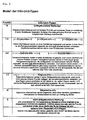
- FIG. 3 shows the structure of an info unit in tabular form 18 (Fig. 1) structured according to different depths of information, which like the priority of object data (Fig.3) Control of playback depending on the speed of movement can serve.
- An info unit is shown using the example of the VW plant
- the controller accesses the info unit with the information depth 1 to. This is a comparatively short one Time (here 55 sec). to disposal. Playing different Information associated with the same depth of information after the serial number.
- the depth of information 1 in this example are serial numbers 1, 2 and 10 assigned. Element 1 is played first, with what before playing element 2, a remaining time of 45 sec. remains. After playing element 2, element becomes 10 with a remaining time of 5 seconds. played.
- the sequence of the elements according to column 2 is chosen logically or conclusively.
- the information is played with a greater information depth, for example 3, the first information element of this information depth is played first and then all subsequent information elements with the same or a lower information depth, here 1 and 2 for example.
- the sequence of the information elements is accordingly chosen so that a curricularly conclusive sequence of the data always results regardless of the depth of information. Therefore, for example, the information element 10 "end" is logically arranged at the last position, because it is always reproduced at the end regardless of the depth of information selected.
- the information depth is 2 125 sec. and for the depth of information 3 155 sec. to disposal.
- the elements of the Info-unit can be arranged according to the direction of travel be, i.e. their inclusion in the sequence of playback the information elements can depend on the direction, in which a route is traveled.
- the system according to the invention is particularly suitable also for train, bus, boat trips and boat trips.
Landscapes
- Engineering & Computer Science (AREA)
- Radar, Positioning & Navigation (AREA)
- Remote Sensing (AREA)
- Automation & Control Theory (AREA)
- Physics & Mathematics (AREA)
- General Physics & Mathematics (AREA)
- Navigation (AREA)
- Traffic Control Systems (AREA)
- Position Fixing By Use Of Radio Waves (AREA)
- Circuits Of Receivers In General (AREA)
Abstract
Description
- Geschwindigkeitsprognose, eventuell selbstlernend;
- zeitliche Steuerung der Wiedergabe im Rahmen sinnvoller Wiedergabezeitspannen;
- Stückelung der Informationsdaten in kleine Einheiten zur Optimierung der Anpassung zwischen Geschwindigkeit und Informationsangebot;
- Differenzierung der jeweils gültigen Streckeninformation nach Priorität (Zugriffswert);
- Curriculare Kohärenz, d.h. eine geschwindigkeitsspezifische Vertiefung bei Einzelthemen unter Wahrung des curricularen Zusammenhangs der Informationen, und
- Steuerung der Themenauswahl und der Informationstiefe durch direkte Beeinflussung durch den Benutzer, z.B. mit Hilfe von Wahlschaltern etc..
- Fig. 1
- einen schematischen Aufbau eines Informationssystems,
- Fig. 2
- eine Zuordnung der auf einem Datenträger des Systems gespeicherten Informationsdaten (Info-units) in unterschiedliche Prioritätsstufen, und
- Fig. 3
- den Aufbau einer Informationsdatei (Info-unit) in Abhängigkeit von der Informationstiefe am Beispiel des VW-Werkes.
Die Steuerung 20 des Systems 10 System ruft beim Einschalten aus dem GPS-Empfänger solange Koordinaten ab, bis eine Koordinate gefunden wird, die auf dem Streckennetz liegt, für das Informationen vorliegen. Hierfür werden die Ortskoordinaten mit den Streckeninformationen (roads) 14 auf der CD bzw. DVD verglichen. Ist die Distanz zwischen Ortskoordinate und verfügbaren Strecken (roads 14) zu groß, wird gemeldet, daß keine Informationen vorliegen (falsche CD eingelegt oder keine Informationen verfügbar).
- weniger Information:
Durch Drücken einer Skip-Taste kann der Reisende die gerade laufende info-unit jederzeit verlassen. Das System spielt dann die Tondateien (wave-tables) 19 aus iener größeren Informationstiefe bzw. aus der nächsten info-unit 18 aus dem moving-menue 24 ein. - mehr Information:
Durch Drücken einer More-Taste kann der Reisende vertiefte Information zu der laufenden info-unit 18 anfordern. Das System senkt dann den depth-level in der info-unit (Fig. 3) auch dann, wenn auf dem moving-menue 24 zeitkritische Informationen höherer Priorität warten.
- die erste Spalte den Namen der Tondatei für die Audiowiedergabe,
- die zweite Spalte eine laufende Nummer der Information,
- die dritte Spalte die Informationstiefe,
- die vierte Spalte die Abspieldauer der zugehörigen Tondatei,
- die fünfte Spalte die Restdauer, als Summe der Albspieldauer dieser und der weiteren in der Info-unit folgenden Tondateien gleicher und geringerer Informationstiefe, und
- die letzte Spalte den Inhalt der Information.
Im Beispiel stehen für die Informationstiefe 2 125 sek. und für die Informationstiefe 3 155 sek. zur Verfügung. Bei der Wiedergabe der Info-unit mit Informationstiefe 3 werden z.B. die Elemente 6,7,9 und 10 sukzessive wiedergegeben.
Claims (13)
- Verfahren zur Bereitstellung von in einem Datenträger abgelegten oder von einem Sender übertragenen Informationsdaten unter Berücksichtigung von Ortsdaten, die über einen GPS-Empfänger erhalten werden, mit folgenden Schritten:die Ortsdaten werden von dem GPS-Empfänger in zeitlichen Abständen abgerufen und zur Berechnung von Bewegungsdaten, zumindest von Bewegungsgeschwindigkeitsdaten verwendet,die in dem Datenträger befindlichen Informationsdaten werden in Abhängigkeit von den aktuellen Ortsdaten und den aktuellen Bewegungsgeschwindigkeitsdaten über eine akustische und/oder optische Ausgabeeinrichtung wiedergegeben.
- Verfahren nach Anspruch 1,
dadurch gekennzeichnet,daß den in dem Datenträger befindlichen Informationsdaten unterschiedliche Prioritäten bzw. Informationstiefen zugeordnet werden,und daß der Zugriff auf die und/oder die Wiedergabe der Informationsdaten prioritätsgesteuert erfolgt, wobei die Priorität bzw. Informationstiefe der wiedergegebenen Daten in Abhängigkeit von dem aktuellen Wert der Bewegungsgeschwindigkeitsdaten ausgewählt wird. - Verfahren nach Anspruch 2,
dadurch gekennzeichnet,daß bereits wiedergegebene Themen zur Vermeidung von Wiederholungen gespeichert werden, und daß Informationen unabhängig von deren Priorität bzw. Informastionstiefe nur dann wiedergegeben werden, wenn sie entweder keinen Bezug zu anderen Themen oder nur einen Bezug zu bereits wiedergegebenen Themen aufweisen, so daß eine curriculare Kohärenz der wiedergegebenen Informationen sichergestellt wird. - Verfahren nach einem der vorhergehenden Ansprüche,
dadurch gekennzeichnet,daß unter den Bewegungsdaten auch Bewegungsrichtungsdaten errechnet werden, unddaß der Streckenverlauf aus den Bewegungsgeschwindigkeitsdaten und Bewegungsrichtungsdaten, gegebenenfalls unter Berücksichtigung von in einem Datenträger abgelegten Verkehrswegedaten errechnet wird. - Verfahren nach einem der vorhergehenden Ansprüche,
dadurch gekennzeichnet,daß auf einem Datenträger sonstige Daten, z.B. Werbedaten gespeichert sind, und daß die Wiedergabe der sonstigen Daten in Abhängigkeit von der Wiedergabe der Informationsdaten und/oder in Abhängigkeit von den Bewegungsdaten gesteuert wird. - Verfahren nach einem der vorhergehenden Ansprüche,
dadurch gekennzeichnet,daß das Verfahren zur Wiedergabe der Informationsdaten in Zusammenhang mit einem GPS-gestützten Navigationssystem unter Verwendung einer Steuerung angewandt wird, die einen Zugriff auf einen gespeicherten, eingegebenen und/oder errechneten Streckenverlauf hat,daß die Pausen zwischen der Wiedergabe von Navigationsdaten seitens des Navigationssystems anhand der aktuellen Bewegungsgeschwindigkeitsdaten und/oder des vorgegebenen Streckenverlaufs errechnet/prognostiziert werden,daß die auf dem Datenträger gespeicherten Informationsdaten mit einem Wert versehen sind, der eine Aussage über die erforderliche Wiedergabezeit enthält,und daß die Steuerung die Wiedergabe der Informationsdaten nur dann veranlaßt, wenn zumindest für einen der Wiedergabe der Informationsdaten entsprechenden Zeitraum keine Wiedergabe von Navigationsdaten errechnet/prognostiziert ist. - Verfahren nach Anspruch 6,
dadurch gekennzeichnet,daß die Steuerung die Wiedergabe der Informationsdaten nur dann veranlaßt, wenn das Verhältnis von Pausen zu Wiedergabezeiten insgesamt in einem vorbestimmten Bereich liegt. - Vorrichtung zur Wiedergabe von auf einem Datenträger (12) gespeicherten oder über einen Sender übertragenen Informationsdaten (19), umfassend eine Steuerung (20), die die Wiedergabe der Informationsdaten in Abhängigkeit von aus einem GPS-Empfänger (22) erhaltenen Ortsdaten veranlaßt,
dadurch gekennzeichnet,daß die Steuerung (20) eine Recheneinheit zum Errechnen von Bewegungsdaten, zumindest Bewegungsgeschwindigkeitsdaten aus sukzessive erhaltenen Ortsdaten umfaßt,daß die auf dem Datenträger (12) gespeicherten Informationsdaten (18) entweder mit einem Zugriffsparameter (16,18) verknüpft und/oder in zugriffsselektiven Datenbereichen abgelegt sind, unddaß die Steuerung (20) eine Schaltung aufweist, die aus den Bewegungsgeschwindigkeitsdaten einen Zugriffssteuerungswert bildet und entsprechend nur auf Daten zugreift, deren Zugriffsparameter (z.B. Priorität, Informationstiefe) und/oder Datenbereich dem ermittelten Zugriffssteuerungswert zugeordnet ist. - Vorrichtung nach Anspruch 8, die in ein Navigationssystem integriert oder mit einem Navigationssystem verbindbar ist,
dadurch gekennzeichnet,daß die Steuerung eine Schaltung umfaßt, die die Wiedergabe der Informationsdaten in Abhängigkeit von der Wiedergabe der Navigationsdaten zeitlich steuert. - Vorrichtung nach Anspruch 8 oder 9,
dadurch gekennzeichnet,daß den sonstigen Daten ein Zugriffsparameter niedriger Priorität zugeordnet ist, unddaß ein Zeitmeßbaustein vorgesehen ist, dessen Ausgangssignal einer Schaltung der Steuerung zuführbar ist, die die Priorität des den sonstigen Informationen zugeordneten Zugriffsparameters in Abhängigkeit vom Ausgangssignal des Zeitmeßbausteins erhöht, so daß die Wiedergabe in einem festgelegten Zeitintervall sichergestellt ist. - Vorrichtung nach einem der Ansprüche 8 bis 10,
dadurch gekennzeichnet,daß die Informationsdaten Streckengültigkeitsdaten umfassen, die Streckenabschnitte definieren - gegebenenfalls gestuft nach möglich und günstig - zu denen die Informationsdaten sinnvoll mitgeteilt werden können. - Vorrichtung nach Anspruch 11,
dadurch gekennzeichnet,daß die Steuerung eine Vorrichtung aufweist, die die Streckengültigkeitsdaten mit aktuellen Verkehrswegedaten und Bewegungsrichtungsdaten zur Generierung von aktuellen Lagedaten verknüpft und die Wiedergabe der Informationsdaten relativ zu den aktuellen Lagedaten veranlaßt. - Vorrichtung nach einem der Ansprüche 8 bis 12,
dadurch gekennzeichnet,daß ein Wiedergabezugriffsspeicher (memory 30)vorgesehen ist, in dem Zugriffsdaten zu nicht ortsbezogenen Informationsdaten oder einen größeren regionalen Bereich betreffende Informationsdaten, wie z.B. Regionsinformationen oder historische Informationen ablegbar sind, unddaß eine Markierungseinrichtung vorgesehen ist, die die im Wiedergabezugriffsspeicher (memory 30) abgelegten Zugriffsdaten nach erfolgter Wiedergabe markiert.
Applications Claiming Priority (2)
| Application Number | Priority Date | Filing Date | Title |
|---|---|---|---|
| DE19841169 | 1998-09-08 | ||
| DE19841169A DE19841169C1 (de) | 1998-09-08 | 1998-09-08 | Verfahren und Vorrichtung zur Bereitstellung von Informationsdaten im Zusammenhang mit einem GPS-System |
Publications (2)
| Publication Number | Publication Date |
|---|---|
| EP0985906A1 true EP0985906A1 (de) | 2000-03-15 |
| EP0985906B1 EP0985906B1 (de) | 2004-12-01 |
Family
ID=7880348
Family Applications (1)
| Application Number | Title | Priority Date | Filing Date |
|---|---|---|---|
| EP99117704A Expired - Lifetime EP0985906B1 (de) | 1998-09-08 | 1999-09-08 | Verfahren und Vorrichtung zur Bereitstellung von Informationsdaten im Zusammenhang mit einem GPS-System |
Country Status (4)
| Country | Link |
|---|---|
| EP (1) | EP0985906B1 (de) |
| AT (1) | ATE284018T1 (de) |
| DE (2) | DE19841169C1 (de) |
| ES (1) | ES2229602T3 (de) |
Cited By (8)
| Publication number | Priority date | Publication date | Assignee | Title |
|---|---|---|---|---|
| EP1205763A1 (de) * | 2000-11-09 | 2002-05-15 | Texas Instruments Incorporated | Drahtlose Ortung |
| EP1126732A3 (de) * | 2000-02-14 | 2002-08-21 | Kabushiki Kaisha Toshiba | Positionsabhängiges Dienstleistungsverfahren und System |
| EP1357360A3 (de) * | 2002-04-26 | 2004-05-19 | Robert Bosch Gmbh | Verfahren zum Betreiben eines Navigationssystems sowie Datenträger für ein Navigationssystem |
| WO2008025690A1 (de) * | 2006-08-30 | 2008-03-06 | Dehn Ruediger | Verfahren und vorrichtungen sowie computerprogramm zur erfassung und nutzung richtungsbezogener information eines objekts |
| EP2009397A3 (de) * | 2007-06-29 | 2011-06-22 | Robert Bosch Gmbh | Verfahren und Vorrichtung zur Übermittlung von Informationen an Fahrzeuginsassen |
| CN101057123B (zh) * | 2004-09-16 | 2011-10-19 | 弗劳恩霍夫应用研究促进协会 | 信息终端及用于信息选择的方法 |
| EP3002558A1 (de) * | 2014-10-03 | 2016-04-06 | Volvo Car Corporation | Verfahren und System zur Vermeidung der Ablenkung eines Fahrzeuginsassen |
| CN115619844A (zh) * | 2022-08-30 | 2023-01-17 | 西安建筑科技大学 | 一种城乡山水环境中观瞰易察点发掘方法 |
Families Citing this family (6)
| Publication number | Priority date | Publication date | Assignee | Title |
|---|---|---|---|---|
| DE10024368A1 (de) * | 2000-05-17 | 2001-11-22 | Michael Fahrmair | Treffen einer Vorauswahl an Informationsangeboten |
| DE10130569B4 (de) * | 2000-06-27 | 2006-11-16 | Thomas Nowara | Mobiler Werbeträger |
| DE10217300C1 (de) | 2002-04-18 | 2003-11-20 | Fraunhofer Ges Forschung | Ortsabhängige Informationswiedergabe unter Anpassung eines geographischen Auswahlparameters |
| DE10225185A1 (de) * | 2002-06-06 | 2003-12-18 | Werner M Bless | Bereitstellen von streckenspezifischen Informationen |
| DE102006001819A1 (de) * | 2006-01-13 | 2007-07-19 | Bayerische Motoren Werke Ag | Verfahren zur Anzeige von Verkehrsmeldungen auf einer Anzeigeeinrichtung eines Navigationssystems und Navigationssystem |
| DE102010048933A1 (de) * | 2009-12-23 | 2011-06-30 | Mayer, Harald, 48163 | Verfahren zur mobilen Wiedergabe von digitalen Informationen an einem Fahrzeug unter Verwendung retroflektierender Materialien |
Citations (5)
| Publication number | Priority date | Publication date | Assignee | Title |
|---|---|---|---|---|
| DE3925831A1 (de) * | 1989-08-04 | 1991-02-07 | Bosch Gmbh Robert | Kraftfahrzeugsteuer- oder regelungssystem |
| FR2691276A1 (fr) * | 1992-04-03 | 1993-11-19 | Parienti Raoul | Système de guide vocal électronique. |
| EP0672890A1 (de) * | 1994-03-18 | 1995-09-20 | Aisin Aw Co., Ltd. | Reiseführersystem |
| US5717392A (en) * | 1996-05-13 | 1998-02-10 | Eldridge; Marty | Position-responsive, hierarchically-selectable information presentation system and control program |
| FR2755284A1 (fr) * | 1996-10-30 | 1998-04-30 | Renault | Procede de restitution d'informations a bord d'un vehicule routier |
Family Cites Families (1)
| Publication number | Priority date | Publication date | Assignee | Title |
|---|---|---|---|---|
| DE19544382C2 (de) * | 1995-11-15 | 1998-01-15 | Mannesmann Ag | Verfahren und Zielführungseinheit zur sicheren Zielführung eines Fahrzeugs |
-
1998
- 1998-09-08 DE DE19841169A patent/DE19841169C1/de not_active Expired - Lifetime
-
1999
- 1999-09-08 AT AT99117704T patent/ATE284018T1/de not_active IP Right Cessation
- 1999-09-08 EP EP99117704A patent/EP0985906B1/de not_active Expired - Lifetime
- 1999-09-08 ES ES99117704T patent/ES2229602T3/es not_active Expired - Lifetime
- 1999-09-08 DE DE59911174T patent/DE59911174D1/de not_active Expired - Fee Related
Patent Citations (5)
| Publication number | Priority date | Publication date | Assignee | Title |
|---|---|---|---|---|
| DE3925831A1 (de) * | 1989-08-04 | 1991-02-07 | Bosch Gmbh Robert | Kraftfahrzeugsteuer- oder regelungssystem |
| FR2691276A1 (fr) * | 1992-04-03 | 1993-11-19 | Parienti Raoul | Système de guide vocal électronique. |
| EP0672890A1 (de) * | 1994-03-18 | 1995-09-20 | Aisin Aw Co., Ltd. | Reiseführersystem |
| US5717392A (en) * | 1996-05-13 | 1998-02-10 | Eldridge; Marty | Position-responsive, hierarchically-selectable information presentation system and control program |
| FR2755284A1 (fr) * | 1996-10-30 | 1998-04-30 | Renault | Procede de restitution d'informations a bord d'un vehicule routier |
Cited By (10)
| Publication number | Priority date | Publication date | Assignee | Title |
|---|---|---|---|---|
| EP1126732A3 (de) * | 2000-02-14 | 2002-08-21 | Kabushiki Kaisha Toshiba | Positionsabhängiges Dienstleistungsverfahren und System |
| EP1205763A1 (de) * | 2000-11-09 | 2002-05-15 | Texas Instruments Incorporated | Drahtlose Ortung |
| EP1357360A3 (de) * | 2002-04-26 | 2004-05-19 | Robert Bosch Gmbh | Verfahren zum Betreiben eines Navigationssystems sowie Datenträger für ein Navigationssystem |
| CN101057123B (zh) * | 2004-09-16 | 2011-10-19 | 弗劳恩霍夫应用研究促进协会 | 信息终端及用于信息选择的方法 |
| US8949284B2 (en) | 2004-09-16 | 2015-02-03 | Fraunhofer-Gesellschaft Zur Foerderung Der Angewandten Forschung E.V. | Information point |
| WO2008025690A1 (de) * | 2006-08-30 | 2008-03-06 | Dehn Ruediger | Verfahren und vorrichtungen sowie computerprogramm zur erfassung und nutzung richtungsbezogener information eines objekts |
| EP2009397A3 (de) * | 2007-06-29 | 2011-06-22 | Robert Bosch Gmbh | Verfahren und Vorrichtung zur Übermittlung von Informationen an Fahrzeuginsassen |
| EP3002558A1 (de) * | 2014-10-03 | 2016-04-06 | Volvo Car Corporation | Verfahren und System zur Vermeidung der Ablenkung eines Fahrzeuginsassen |
| US9758174B2 (en) | 2014-10-03 | 2017-09-12 | Volvo Car Corporation | Method and system for avoiding distracting a vehicle occupant |
| CN115619844A (zh) * | 2022-08-30 | 2023-01-17 | 西安建筑科技大学 | 一种城乡山水环境中观瞰易察点发掘方法 |
Also Published As
| Publication number | Publication date |
|---|---|
| DE19841169C1 (de) | 2000-03-30 |
| DE59911174D1 (de) | 2005-01-05 |
| ES2229602T3 (es) | 2005-04-16 |
| ATE284018T1 (de) | 2004-12-15 |
| EP0985906B1 (de) | 2004-12-01 |
Similar Documents
| Publication | Publication Date | Title |
|---|---|---|
| EP0985906B1 (de) | Verfahren und Vorrichtung zur Bereitstellung von Informationsdaten im Zusammenhang mit einem GPS-System | |
| DE19743249B4 (de) | Navigationsvorrichtung | |
| DE112007002882B4 (de) | Navigationsvorrichtung | |
| DE69931683T2 (de) | Fahrzeugnavigationsvorrichtung | |
| DE69229946T2 (de) | Navigationsvorrichtung für fahrzeuge | |
| DE69719434T2 (de) | Fahrzeugnavigationsgerät und Speichermedium | |
| DE60214060T2 (de) | Vorrichtung zur Bereitstellung einer Wegbeschreibung | |
| EP0331675B2 (de) | System zur ausgabe von wegeinformationen für fahrer von landfahrzeugen und informationsausgabesystem | |
| DE102005031409B4 (de) | Fahrzeugnavigationssystem und Computerprogrammprodukt | |
| DE4034681A1 (de) | System zur uebertragung von verkehrsinformationen zwischen fahrzeugen und zur steuerung | |
| EP2100283A1 (de) | Zielführungsverfahren und anordnung zur durchführung eines solchen sowie ein entsprechendes computerprogramm und ein entsprechendes computerlesbares speichermedium | |
| EP1186866A2 (de) | Navigationsvorrichtung | |
| EP1162559A2 (de) | Verfahren zur elektronischen Terminplanung und elektronischer Terminplaner hierfür | |
| DE102007038464A1 (de) | Verfahren zum Betrieb einer Einrichtung | |
| EP0300205B1 (de) | Verfahren zur fahrtroutenselektiven Wiedergabe von Verkehrsnachrichten sowie Fahrzeugempfänger | |
| EP1062481B1 (de) | Verfahren zur ausgabe von verkehrsinformationen | |
| DE19540864B4 (de) | Navigationsvorrichtung für ein Fahrzeug | |
| DE19740602B4 (de) | Verkehrsleit-, Informations- und Positionierungssystem (VIPS) | |
| EP0410137B1 (de) | Verfahren und Vorrichtung zur Steuerung einer Wiedergabeeinrichtung für ortsabhängige Informationen | |
| DE102018133442A1 (de) | Verfahren zum Ausgeben von Informationen in einem Fahrzeug und Vorrichtung zum Steuern einer Ausgabe von Informationen in einem Fahrzeug | |
| EP1890112B1 (de) | Verfahren zum Darstellen von Objektinformation und Navigationssystem hierfür | |
| EP1957939B1 (de) | Vorrichtung und verfahren zur ausgabe von zielführungsinformationen eines navigationssystems | |
| DE10253135B4 (de) | Verfahren und Vorrichtung zur Aufbereitung von Verkehrsinformationen | |
| DE2700930A1 (de) | Auto-commander | |
| DE19947790A1 (de) | Navigationssystem mit automatischem Datenträgerwechsel |
Legal Events
| Date | Code | Title | Description |
|---|---|---|---|
| PUAI | Public reference made under article 153(3) epc to a published international application that has entered the european phase |
Free format text: ORIGINAL CODE: 0009012 |
|
| AK | Designated contracting states |
Kind code of ref document: A1 Designated state(s): AT BE CH CY DE DK ES FI FR GB GR IE IT LI LU MC NL PT SE |
|
| AX | Request for extension of the european patent |
Free format text: AL;LT;LV;MK;RO;SI |
|
| 17P | Request for examination filed |
Effective date: 20000824 |
|
| AKX | Designation fees paid |
Free format text: AT BE CH CY DE DK ES FI FR GB GR IE IT LI LU MC NL PT SE |
|
| 17Q | First examination report despatched |
Effective date: 20031016 |
|
| GRAP | Despatch of communication of intention to grant a patent |
Free format text: ORIGINAL CODE: EPIDOSNIGR1 |
|
| GRAS | Grant fee paid |
Free format text: ORIGINAL CODE: EPIDOSNIGR3 |
|
| GRAA | (expected) grant |
Free format text: ORIGINAL CODE: 0009210 |
|
| AK | Designated contracting states |
Kind code of ref document: B1 Designated state(s): AT BE CH CY DE DK ES FI FR GB GR IE IT LI LU MC NL PT SE |
|
| PG25 | Lapsed in a contracting state [announced via postgrant information from national office to epo] |
Ref country code: NL Free format text: LAPSE BECAUSE OF FAILURE TO SUBMIT A TRANSLATION OF THE DESCRIPTION OR TO PAY THE FEE WITHIN THE PRESCRIBED TIME-LIMIT Effective date: 20041201 Ref country code: IT Free format text: LAPSE BECAUSE OF FAILURE TO SUBMIT A TRANSLATION OF THE DESCRIPTION OR TO PAY THE FEE WITHIN THE PRESCRIBED TIME-LIMIT;WARNING: LAPSES OF ITALIAN PATENTS WITH EFFECTIVE DATE BEFORE 2007 MAY HAVE OCCURRED AT ANY TIME BEFORE 2007. THE CORRECT EFFECTIVE DATE MAY BE DIFFERENT FROM THE ONE RECORDED. Effective date: 20041201 Ref country code: IE Free format text: LAPSE BECAUSE OF FAILURE TO SUBMIT A TRANSLATION OF THE DESCRIPTION OR TO PAY THE FEE WITHIN THE PRESCRIBED TIME-LIMIT Effective date: 20041201 Ref country code: GB Free format text: LAPSE BECAUSE OF FAILURE TO SUBMIT A TRANSLATION OF THE DESCRIPTION OR TO PAY THE FEE WITHIN THE PRESCRIBED TIME-LIMIT Effective date: 20041201 Ref country code: FR Free format text: LAPSE BECAUSE OF NON-PAYMENT OF DUE FEES Effective date: 20041201 Ref country code: FI Free format text: LAPSE BECAUSE OF FAILURE TO SUBMIT A TRANSLATION OF THE DESCRIPTION OR TO PAY THE FEE WITHIN THE PRESCRIBED TIME-LIMIT Effective date: 20041201 |
|
| REG | Reference to a national code |
Ref country code: GB Ref legal event code: FG4D Free format text: NOT ENGLISH |
|
| REG | Reference to a national code |
Ref country code: CH Ref legal event code: EP |
|
| REG | Reference to a national code |
Ref country code: IE Ref legal event code: FG4D Free format text: GERMAN |
|
| REF | Corresponds to: |
Ref document number: 59911174 Country of ref document: DE Date of ref document: 20050105 Kind code of ref document: P |
|
| PG25 | Lapsed in a contracting state [announced via postgrant information from national office to epo] |
Ref country code: SE Free format text: LAPSE BECAUSE OF FAILURE TO SUBMIT A TRANSLATION OF THE DESCRIPTION OR TO PAY THE FEE WITHIN THE PRESCRIBED TIME-LIMIT Effective date: 20050301 Ref country code: GR Free format text: LAPSE BECAUSE OF FAILURE TO SUBMIT A TRANSLATION OF THE DESCRIPTION OR TO PAY THE FEE WITHIN THE PRESCRIBED TIME-LIMIT Effective date: 20050301 Ref country code: DK Free format text: LAPSE BECAUSE OF FAILURE TO SUBMIT A TRANSLATION OF THE DESCRIPTION OR TO PAY THE FEE WITHIN THE PRESCRIBED TIME-LIMIT Effective date: 20050301 |
|
| REG | Reference to a national code |
Ref country code: ES Ref legal event code: FG2A Ref document number: 2229602 Country of ref document: ES Kind code of ref document: T3 |
|
| NLV1 | Nl: lapsed or annulled due to failure to fulfill the requirements of art. 29p and 29m of the patents act | ||
| GBV | Gb: ep patent (uk) treated as always having been void in accordance with gb section 77(7)/1977 [no translation filed] |
Effective date: 20041201 |
|
| REG | Reference to a national code |
Ref country code: IE Ref legal event code: FD4D |
|
| PG25 | Lapsed in a contracting state [announced via postgrant information from national office to epo] |
Ref country code: CY Free format text: LAPSE BECAUSE OF FAILURE TO SUBMIT A TRANSLATION OF THE DESCRIPTION OR TO PAY THE FEE WITHIN THE PRESCRIBED TIME-LIMIT Effective date: 20050908 Ref country code: AT Free format text: LAPSE BECAUSE OF NON-PAYMENT OF DUE FEES Effective date: 20050908 |
|
| PG25 | Lapsed in a contracting state [announced via postgrant information from national office to epo] |
Ref country code: MC Free format text: LAPSE BECAUSE OF NON-PAYMENT OF DUE FEES Effective date: 20050930 Ref country code: LU Free format text: LAPSE BECAUSE OF NON-PAYMENT OF DUE FEES Effective date: 20050930 Ref country code: LI Free format text: LAPSE BECAUSE OF NON-PAYMENT OF DUE FEES Effective date: 20050930 Ref country code: CH Free format text: LAPSE BECAUSE OF NON-PAYMENT OF DUE FEES Effective date: 20050930 Ref country code: BE Free format text: LAPSE BECAUSE OF NON-PAYMENT OF DUE FEES Effective date: 20050930 |
|
| PLBE | No opposition filed within time limit |
Free format text: ORIGINAL CODE: 0009261 |
|
| STAA | Information on the status of an ep patent application or granted ep patent |
Free format text: STATUS: NO OPPOSITION FILED WITHIN TIME LIMIT |
|
| 26N | No opposition filed |
Effective date: 20050902 |
|
| EN | Fr: translation not filed | ||
| REG | Reference to a national code |
Ref country code: CH Ref legal event code: PL |
|
| BERE | Be: lapsed |
Owner name: *EBERHARD JOST Effective date: 20050930 Owner name: *PEITHMANN ORTWIN Effective date: 20050930 |
|
| PG25 | Lapsed in a contracting state [announced via postgrant information from national office to epo] |
Ref country code: PT Free format text: LAPSE BECAUSE OF NON-PAYMENT OF DUE FEES Effective date: 20050501 |
|
| PGFP | Annual fee paid to national office [announced via postgrant information from national office to epo] |
Ref country code: DE Payment date: 20080924 Year of fee payment: 10 |
|
| PGFP | Annual fee paid to national office [announced via postgrant information from national office to epo] |
Ref country code: ES Payment date: 20080929 Year of fee payment: 10 |
|
| PG25 | Lapsed in a contracting state [announced via postgrant information from national office to epo] |
Ref country code: DE Free format text: LAPSE BECAUSE OF NON-PAYMENT OF DUE FEES Effective date: 20100401 |
|
| REG | Reference to a national code |
Ref country code: ES Ref legal event code: FD2A Effective date: 20110714 |
|
| PG25 | Lapsed in a contracting state [announced via postgrant information from national office to epo] |
Ref country code: ES Free format text: LAPSE BECAUSE OF NON-PAYMENT OF DUE FEES Effective date: 20110704 |
|
| PG25 | Lapsed in a contracting state [announced via postgrant information from national office to epo] |
Ref country code: ES Free format text: LAPSE BECAUSE OF NON-PAYMENT OF DUE FEES Effective date: 20090909 |