WO2024111192A1 - 運転支援装置 - Google Patents
運転支援装置 Download PDFInfo
- Publication number
- WO2024111192A1 WO2024111192A1 PCT/JP2023/030792 JP2023030792W WO2024111192A1 WO 2024111192 A1 WO2024111192 A1 WO 2024111192A1 JP 2023030792 W JP2023030792 W JP 2023030792W WO 2024111192 A1 WO2024111192 A1 WO 2024111192A1
- Authority
- WO
- WIPO (PCT)
- Prior art keywords
- vehicle
- information
- communication information
- driving
- acquisition area
- Prior art date
- Legal status (The legal status is an assumption and is not a legal conclusion. Google has not performed a legal analysis and makes no representation as to the accuracy of the status listed.)
- Ceased
Links
Images

Classifications
-
- G—PHYSICS
- G08—SIGNALLING
- G08G—TRAFFIC CONTROL SYSTEMS
- G08G1/00—Traffic control systems for road vehicles
- G08G1/16—Anti-collision systems
Definitions
- the present invention relates to a driving assistance device for a moving object such as a vehicle that acquires information about the surroundings of the vehicle using communications and uses that information to provide driving assistance.
- the information obtained through the above communications contains a huge amount of information, including information on objects sensed by vehicles equipped with communication terminals and roadside infrastructure.
- the driving assistance device on the vehicle that receives this information is limited in the amount of available memory and computing resources, and is therefore unable to receive all information, so a mechanism is required to receive only the information that is necessary.
- Patent Document 1 is an example of a conventional technique that employs such a mechanism.
- Patent Document 1 discloses an on-board electronic control device that determines a travel area based on the travel path of the vehicle itself, and stores in a storage unit information on objects present within the travel path area that have been detected by other vehicles and obtained through vehicle-to-vehicle communication.
- Patent Document 1 By using the conventional technology disclosed in Patent Document 1, memory usage can be reduced.
- the travel path area from which information is acquired is set based on the vehicle's planned travel path in the future, so there is a high possibility that information will be insufficient when implementing the following driving assistance, and appropriate driving assistance may not be implemented.
- information on adjacent lanes behind the vehicle is essential, but the travel path area in Patent Document 1 does not include the area behind the vehicle, making it difficult to properly implement lane change assistance.
- the present invention was made in consideration of the above-mentioned circumstances, and aims to provide a driving assistance device that, when acquiring information about the surroundings of the vehicle using communication, can select the acquired information without eliminating information necessary for driving assistance for the vehicle, and can exclude unnecessary information.
- a driving assistance device mounted on a vehicle includes a surrounding environment recognition unit that recognizes the surrounding environment of the vehicle based on map information and on-board sensor information from a sensor mounted on the vehicle, a driving assistance determination unit that determines driving assistance for the vehicle based on information from the surrounding environment recognition unit, a communication information acquisition unit that acquires communication information transmitted from outside the vehicle, a driving behavior determination unit that determines possible driving behavior of the vehicle based on the on-board sensor information and the map information, a communication information acquisition area setting unit that sets an acquisition area for the communication information based on the driving behavior, and a communication information acquisition determination unit that selects communication information that may affect the driving behavior of the vehicle from the communication information present in the acquisition area, and the surrounding environment recognition unit recognizes the surrounding environment of the vehicle using the communication information selected by the communication information acquisition determination unit.
- FIG. 1 is a schematic configuration diagram of a driving assistance device according to an embodiment of the present invention
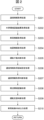
- 2 is a flowchart of an overall process of a driving assistance device according to an embodiment of the present invention.
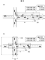
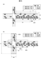
- 3A and 3B are diagrams for explaining a specific example of the present invention (passing an intersection), in which (a) is an example of acquisition area setting and target information selection in a situation where the distance from the vehicle to the intersection is sufficiently far away, and (b) is an example of acquisition area setting and target information selection in a situation where the vehicle approaches the intersection from the situation in FIG. 3A and the distance to the intersection is within a predetermined value.
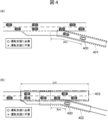
- 4A and 4B are diagrams for explaining a specific example of the present invention (passing a merging point), in which FIG.
- FIG. 4A is an example of acquisition area setting and target information selection in a situation in which the distance from the host vehicle to the merging start point is sufficiently far away
- FIG. 4B is an example of acquisition area setting and target information selection in a situation in which the host vehicle approaches the merging point from the situation in FIG. 4A and the distance to the merging start point is within a predetermined value
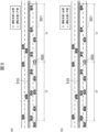
- 1A and 1B are diagrams for explaining a specific example of the present invention (driving in a driving lane (left lane) of a motorway), in which (a) is an example of acquisition area setting and target information selection, and (b) is another example of acquisition area setting and target information selection.
- 6A and 6B are diagrams for explaining a specific example of the present invention (passing an intersection), in which (a) is an example of acquisition area setting and target information selection in a situation where the distance from the vehicle to the intersection is sufficiently far away, and (b) is an example of acquisition area setting and target information selection in a situation where the vehicle approaches the intersection from the situation in FIG. 6A and the distance to the intersection is within a predetermined value.
- 4A to 4C are diagrams for explaining specific examples of target information acquired in the present invention.
- FIG. 1 is a schematic diagram of a driving assistance device according to one embodiment of the present invention.
- the control device 100a as a driving assistance device illustrated in FIG. 1 is a computer that controls the vehicle, and functions as a communication information acquisition unit 1, a map information acquisition unit 2, a driving behavior determination unit 3, a communication information acquisition area setting unit 4, a communication information acquisition determination unit 5, a surrounding environment recognition unit 6, a driving assistance determination unit 7, a vehicle control unit 8, and an HMI control unit 9 by executing programs stored in a storage medium (not shown).
- the control device 100a is connected to the steering device 111, drive device 112, braking device 113, and transmission device 114 of the vehicle, as well as to a communication device 101, external environment recognition device 102, sound generating device 115, and display device 116 provided in the vehicle.
- the control device 100a is also connected to transmission paths such as the vehicle's CAN (not shown) and dedicated lines, and vehicle information such as the vehicle speed, steering angle, and shift position, as well as user operation information such as switch input and touch panel input, are input via these transmission paths.
- the communication device 101 communicates with the outside of the vehicle using wireless communication methods such as Wi-Fi (IEEE802.11), 4G, 5G, etc., and receives information necessary for driving support of the vehicle.
- the communication partners with the outside of the vehicle include communication devices mounted on other vehicles, communication devices of various infrastructures installed on the roadside (traffic lights, ETC gates, dedicated equipment, etc.), mobile phones held by people, data centers (equipment that accumulates multiple pieces of information and transmits necessary information), etc.
- the information received by the vehicle includes target information (information about the communication partner itself, information sensed by the communication partner, etc.), traffic light information (current traffic light color, time until the traffic light color changes to another color, etc.), speed regulation information (regulated speed, restricted section, etc.), lane regulation information (regulated lanes, restricted sections, etc.), congestion information (congested sections, end position of congestion, etc.), road construction information (construction location, restriction details, etc.), accident information (accident location, restriction details, etc.), weather information (weather details, section information, etc
- Target information includes the type of target (such as a regular car, large vehicle, emergency vehicle, motorcycle, bicycle, person, or other unidentifiable object), position, speed, direction of movement, and reliability (the degree to which the information can be trusted, for example, a value from 1 to 100, with 100 being the most reliable value).
- type of target such as a regular car, large vehicle, emergency vehicle, motorcycle, bicycle, person, or other unidentifiable object
- position, speed, direction of movement and reliability (the degree to which the information can be trusted, for example, a value from 1 to 100, with 100 being the most reliable value).
- the external environment recognition device 102 is a device that acquires information about the environment surrounding the vehicle, and is, for example, an on-board camera such as a monocular camera or stereo camera that captures the environment surrounding the vehicle. Images acquired by the on-board camera are output to the control device 100a via a transmission path such as a dedicated line, either as analog data or after A/D conversion.
- an on-board camera such as a monocular camera or stereo camera that captures the environment surrounding the vehicle. Images acquired by the on-board camera are output to the control device 100a via a transmission path such as a dedicated line, either as analog data or after A/D conversion.
- other devices that can be used include radar that measures the distance to an object using millimeter waves or laser light, and sonar that measures the distance to an object using ultrasound. These devices such as on-board cameras may be configured to output information such as the distance to the detected object, its direction, speed, and type of object to the control device 100a via a transmission path such as a dedicated line.
- the steering device 111 is composed of an electric power steering, a hydraulic power steering, or the like, which can control the steering angle using an electric or hydraulic actuator in response to an external drive command.
- the drive device 112 is composed of an engine system that can control engine torque using an electric throttle or the like based on an external drive command, and an electric powertrain system that can control the driving force of a motor or the like based on an external drive command, etc.
- the braking device 113 is composed of an electric brake or a hydraulic brake, etc., which can control the braking force using an electric or hydraulic actuator in response to an external braking command.
- the speed change device 114 is composed of a transmission that can switch between forward and reverse using an electric or hydraulic actuator in response to an external gear change command.
- the sound generating device 115 is composed of a speaker or the like, and functions as an information notification unit that outputs warnings, audio guidance, etc. to the driver.
- the display device 116 is composed of a display of a navigation device or the like, a meter panel, warning lights, etc.
- the display device 116 functions as an information notification unit that notifies the driver of information such as the operation screen of the control device 100a and a warning screen that visually notifies the driver that there is a risk of the vehicle colliding with an obstacle.
- the communication information acquisition unit 1 acquires information (communication information) necessary for driving assistance of the vehicle received by the communication device 101 (transmitted from outside the vehicle).
- the map information acquisition unit 2 acquires map information about the area around the vehicle.
- the acquired map information includes shape data that resembles the actual road shape, expressed using polygons and polylines, traffic regulation information (speed limits, types of vehicles that can pass, etc.), lane divisions (main lane, passing lane, climbing lane, straight lane, left turn lane, right turn lane, etc.), the types and positions of lane markings, the presence or absence of traffic lights and signs (if present, their position information), etc.
- the driving behavior determination unit 3 determines possible driving behaviors of the vehicle using information on the surrounding environment of the vehicle recognized by the external environment recognition device 102 and map information around the vehicle acquired by the map information acquisition unit 2. Specifically, the driving behavior of the vehicle is determined using the type of road the vehicle is traveling on (motorway, general road, etc.), the speed limit, the lane position the vehicle is traveling in, the shape of intersections and merging roads the vehicle will be traveling in the future and the distance to those intersections, the current vehicle speed, etc., and may be, for example, that the vehicle is traveling at 45 km/h in the right lane of a general road with two lanes on each side and a speed limit of 50 km/h, and is about to enter a crossroads 100 m ahead. Other examples include that the vehicle is traveling at 38 km/h on a one-lane connecting road with a speed limit of 40 km/h that leads to a motorway, and is about to merge into the main road at a merging road 150 m ahead.
- the communication information acquisition area setting unit 4 sets an area (acquisition area) for selecting information (communication information) acquired by the communication information acquisition unit 1 based on the driving action that the vehicle can take as determined by the driving action determination unit 3. For example, if the driving action of the vehicle is to enter a crossroads intersection, the intersecting road is set as the acquisition area in addition to the road on which the vehicle is traveling. Also, if the driving action of the vehicle is to enter a merging road, the main lanes before and after the merging section are set as the acquisition area in addition to the connecting road on which the vehicle is traveling.
- the communication information acquisition and judgment unit 5 selects information within the area set by the communication information acquisition area setting unit 4 that may affect the driving behavior that the host vehicle can take as determined by the driving behavior judgment unit 3. For example, if the driving behavior of the host vehicle is to enter a crossroads intersection, the communication information acquisition and judgment unit 5 selects information such as vehicles traveling on the intersecting road in the direction of the intersection, people walking on the crosswalk at the intersection, and color information of traffic lights in the direction the host vehicle is traveling.
- the surrounding environment recognition unit 6 detects obstacles around the vehicle and free spaces in which the vehicle can travel, using information input from the external environment recognition device 102, map information acquired by the map information acquisition unit 2, and communication information selected by the communication information acquisition and determination unit 5.
- the type, position, movement direction, movement speed, etc. are detected.
- Types of obstacles include vehicles such as regular cars, large vehicles, and emergency vehicles, motorcycles, bicycles, pedestrians, guardrails, curbs, walls, fences, plants, fallen objects, etc.
- the type and position of obstacles can be detected using a method using pattern matching, which is a known technology, but other technologies may also be used.
- area information in which the vehicle can travel is detected using dividing lines, road edges, road surface information on which the vehicle can travel, obstacle information, etc.
- the driving assistance determination unit 7 determines appropriate driving assistance based on the output of the surrounding environment recognition unit 6.
- driving assistance include automatic emergency braking that predicts a collision with an obstacle and issues an alarm and brakes the vehicle, lane change/merging assistance that assists in changing lanes at the appropriate time by taking into account the relative position of vehicles in adjacent lanes, low-speed vehicle overtaking assistance that assists in overtaking a slow vehicle ahead by crossing into the oncoming lane, and traffic light passing assistance that assists in passing through areas with traffic lights based on information on the current color of the traffic lights and future color changes.
- the vehicle control unit 8 controls the traveling of the vehicle based on the content of the driving assistance determined by the driving assistance determination unit 7. For example, when performing steering assistance into an adjacent lane and speed adjustment as lane change/merging assistance, the vehicle control unit 8 calculates a target steering angle and target speed according to the situation. The vehicle control unit 8 then outputs a target steering torque for achieving the target steering angle to the steering device 111. The vehicle control unit 8 also outputs a target engine torque and target brake pressure for achieving the target speed to the drive device 112 and the braking device 113. In addition, when it is necessary to change the traveling direction of the vehicle for another driving assistance, a gear shift command is output to the transmission 114.
- the HMI control unit 9 generates information to notify the user according to the situation, based on the contents of the driving assistance determined by the driving assistance determination unit 7, and outputs the information to the sound generating device 115 and the display device 116. For example, when outputting an automatic emergency braking warning, an output signal for an automatic emergency braking warning is sent to each of the sound generating device 115 and the display device 116.
- FIG. 2 is a flowchart showing an example of the processing procedure of the control device 100a.
- control device 100a acquires communication information received from the communication device 101 via communication.
- control device 100a acquires the recognition results of the external environment from the external environment recognition device 102.
- vehicle information such as the vehicle's speed, steering angle, and shift position is acquired.
- map information about the area around the vehicle is acquired.
- process S205 the driving behavior of the vehicle is determined based on the external environment recognition results obtained in process S202 and the map information obtained in process S204.
- an acquisition area is set for selecting the communication information acquired in process S201 based on the driving behavior determined in process S205.
- process S207 information that may affect the driving behavior determined in process S205 is selected from the information within the acquisition area set in process S206.
- the communication information acquired in process S201, the map information acquired in process S204, and the communication information selected in process S207 are used to detect obstacles around the vehicle and free spaces in which the vehicle can travel.
- process S209 appropriate driving assistance is determined based on the output of process S208.
- process S210 the vehicle's driving is controlled based on the driving assistance determined in process S209. In addition, information to notify the user is output, and the process ends.
- Figures 3(a) and (b) assume a situation in which the vehicle 300 is traveling toward an intersection.
- information on vehicles other than the vehicle 300, pedestrians, and bicycles is all acquired by the communication information acquisition unit 1.
- the communication information acquisition area setting unit 4 sets the dashed line area 301 as the acquisition area.
- the width Wl in the left direction of the vehicle 300 is set to the range that can cover the area of the left sidewalk
- the width Wr in the right direction is set to the range that can cover the area of the right sidewalk
- the length Lf in the forward direction is set to the range that can avoid a head-on collision with an oncoming vehicle
- the length Lr in the backward direction is set to the range that can avoid a collision with a following vehicle.
- the width of the sidewalk is calculated based on the information recognized by the external environment recognition device 102, or a predetermined width (for example, 5 m) from the boundary of the roadway is used as the width of the sidewalk.
- a predetermined width for example, 5 m
- the value at which the relative speed between the oncoming vehicle and the vehicle is maximized is calculated using the speed limit information in the map information or the speed information of the vehicle, and is calculated, for example, taking into consideration the timing of issuing an automatic emergency brake warning.
- the maximum value of the relative speed may be calculated slightly larger.
- the value at which the relative speed between the following vehicle and the own vehicle is maximum is calculated using the speed limit information of the map information or the speed information of the own vehicle, and for example, the calculation is performed taking into consideration the timing of issuing an automatic emergency brake warning.
- the acquisition area when setting the acquisition area based on the vehicle's speed during driving behavior or the speed limit of the road on which the vehicle is traveling, the acquisition area is set wide when the vehicle's speed or speed limit is high, and is set narrow when the vehicle's speed or speed limit is low (in other words, the acquisition area is expanded or reduced depending on the vehicle's speed or speed limit).
- the acquisition area is expanded or reduced depending on the vehicle's speed or speed limit.
- the communication information acquisition judgment unit 5 selects target information from the target information within the dashed area 301 that may interfere with the driving behavior of the vehicle 300 (selected targets are marked with a circle in Figure 3(a) and unselected targets are marked with an x). With regard to targets that exist in the vicinity of the vehicle 300, all target information within a specified range (e.g., within 10 m) of the vehicle 300 is selected, taking into consideration the possibility of a sudden change in the driving behavior of the vehicle 300 or a sudden change in the movement of the target.
- a specified range e.g., within 10 m
- targets in front of the vehicle 300 all targets are basically selected because they are in the traveling direction of the vehicle 300, but targets moving in the same direction as the vehicle 300 and far from the vehicle 300 (e.g., farther than Lf/2) may be determined to have a low risk of interference with the vehicle 300 and not selected.
- targets approaching the vehicle 300 and having a long predicted time to reach the vehicle 300 e.g., predicted time of 3 seconds or more
- targets whose time or distance to reach the vicinity of the vehicle (a predetermined distance from the vehicle) is within a predetermined value may be selected.
- targets moving in the same direction as the vehicle 300 are basically selected, but if the target type is a person, it is not selected (because a person is selected in the vicinity of the vehicle 300, it is sufficient). In other words, the conditions for selection may be changed based on the target type.
- targets such as vehicles in the oncoming lane
- targets are not selected because they are unlikely to interfere with the vehicle 300.
- Figure 3(b) shows a situation in which the vehicle 300 approaches an intersection from the situation in Figure 3(a) and the distance Xc to the intersection is within a predetermined value.
- the driving behavior of the vehicle 300 at this time is "driving on a one-lane road and about to enter a crossroads intersection", and in addition to the content in Figure 3(a), it is possible to additionally consider the content such as going straight/turning right/turning left at the crossroads intersection. Taking these driving behaviors into consideration, the communication information acquisition area setting unit 4 sets the dashed line area 303 as an acquisition area in addition to the dashed line area 302 equivalent to the dashed line area 301 in Figure 3(a).
- the method of setting the dashed line area 302 is the same as the dashed line area 301, and the size of the dashed line area 303 is set so that the width Wc of the crossing road is a range that can cover the areas of the sidewalks on both sides, and the length Lc of the crossing road is a range that can avoid a collision with a crossing vehicle.
- Wc if the width of the sidewalk can be obtained from the map information, that value is used. If the width cannot be obtained from the map information (including the case where the map information does not include sidewalk information), the width of the sidewalk is calculated based on the information recognized by the external environment recognition device 102, or a predetermined width (e.g., 5 m) from the boundary of the road is used as the width of the sidewalk.
- the value at which the speed of the crossing vehicle is maximum is obtained using the speed limit information in the map information, and is calculated, for example, taking into consideration the timing of issuing an automatic emergency brake warning.
- the speed limit is 50 km/h
- the maximum speed of the crossing vehicle is also 50 km/h
- the timing of issuing an automatic emergency brake warning is the predicted time until collision of 3 seconds
- the width of the road on which the vehicle 300 is traveling is 6 m
- Lc (50 ⁇ 3.6 ⁇ 3) ⁇ 2+6 ⁇ 89 [m]
- the maximum value of the relative speed may be calculated slightly larger.
- the timing for setting the dashed-dotted line region 303 is set so that the distance Xc from the vehicle 300 to the intersection is within a predetermined value.
- This predetermined value may be set to a fixed value (e.g., 100 m), or the time it takes for the vehicle 300 to reach the intersection may be set (e.g., 3 seconds) and the distance calculated by multiplying this time by the vehicle speed of the vehicle 300 may be set as the predetermined value.
- the dashed-dotted line region 303 can be set at a more appropriate timing.
- the vehicle speed of the vehicle 300 decreases after the dashed-dotted line region 303 is set, the above-mentioned predetermined value decreases, and the condition for setting the dashed-dotted line region 303 is no longer met. If the dashed-dotted line region 303 is deleted after the dashed-dotted line region 303 is set, the target information selected within the dashed-dotted line region 303 also disappears, resulting in a high inflow and outflow of information, which is inefficient. Therefore, it is desirable not to delete the dashed-dotted line region 303 set until the vehicle 300 passes the intersection after setting the dashed-dotted line region 303 of the intersection region.
- the communication information acquisition and judgment unit 5 selects target information that may interfere with the driving behavior of the vehicle 300 from the target information within the dashed line area 302 and the dashed line area 303 (selected targets are marked with a circle in FIG. 3(b) and unselected targets are marked with an x).
- the selection method within the dashed line area 302 is the same as the method described in FIG. 3(a).
- the selection method within the dashed line area 303 is as follows. All targets that exist in an area starting from an intersection (for example, an area where the dashed line area 302 and the dashed line area 303 overlap) are selected because they are likely to interfere with the driving behavior of the vehicle 300.
- targets entering the intersection all targets are basically selected, but targets that have a long predicted time to reach the intersection (for example, a predicted time of 3 seconds or more) may be determined to have a low risk of interference with the vehicle 300 and may be unselected. In other words, targets within a predetermined range from the intersection may be selected. Targets moving away from the intersection are not selected because there is no possibility of them interfering with the vehicle 300.
- Figures 4(a) and (b) assume a situation in which the vehicle 400 is traveling on a connecting road (without sidewalks) toward a junction with a motorway. Here, it is assumed that information about all vehicles other than the vehicle 400 is acquired by the communication information acquisition unit 1.
- Figure 4(a) shows a case where the distance Xm from the vehicle 400 to the merging start point is sufficiently far away, and the vehicle 400 is heading toward the merging start point on a one-lane connecting road.
- the driving behavior of the vehicle 400 at this time is "driving on the one-lane connecting road", and other possible driving behaviors include decelerating/accelerating/stopping according to the situation of the preceding vehicle. Taking these driving behaviors into consideration, the communication information acquisition area setting unit 4 sets the dashed line area 401 as the acquisition area.
- the length in the forward direction is set to the range in which a collision with the preceding vehicle can be avoided
- the length in the backward direction is set to the range in which a collision with the following vehicle can be avoided
- the width is set to the range of the road width because there is no sidewalk on this connecting road.
- the length in the forward direction is calculated by using the speed limit information in the map information or the speed information of the vehicle to find the value at which the relative speed between the preceding vehicle and the vehicle is maximized, and is calculated taking into consideration the timing of issuing an automatic emergency brake warning, for example.
- the value at which the relative speed between the following vehicle and the vehicle is maximized is calculated using the speed limit information in the map information or the speed information of the vehicle, and the calculation is performed, for example, taking into consideration the timing for implementing the automatic emergency brake warning.
- Lf changes suddenly at the point of change, and the entrance and exit of target information at the boundary of the range also changes suddenly.
- the acquisition area when setting the acquisition area based on the speed of the vehicle during driving behavior or the speed limit of the road on which the vehicle is traveling, the acquisition area is set wide when the speed or speed limit of the vehicle is high, and is set narrow when the speed or speed limit of the vehicle is low (in other words, the acquisition area is expanded or reduced according to the speed or speed limit of the vehicle).
- the acquisition area is expanded or reduced according to the speed or speed limit of the vehicle.
- the communication information acquisition and judgment unit 5 selects target information from the target information within the dashed line area 401 that may interfere with the driving behavior of the vehicle 400 (selected targets are marked with a circle in FIG. 4(a) and unselected targets are marked with an x).
- targets in front of the vehicle 400 all targets are basically selected because they are targets in the direction of travel of the vehicle 400, but if there are multiple vehicles lined up in front of the vehicle 400, targets beyond a predetermined number (e.g., beyond the third vehicle) may be determined to have a low risk of interference with the vehicle 400 and may not be selected.
- targets behind the vehicle 400 all targets are basically selected because they move in the same direction as the vehicle 400, but if there are multiple vehicles lined up behind the vehicle 400, targets beyond a predetermined number (e.g., beyond the third vehicle) may be determined to have a low risk of interference with the vehicle 400 and may not be selected. In other words, a predetermined number of targets (e.g., up to two targets in front of and behind the vehicle 400) moving in the same direction as the vehicle 400's traveling direction may be selected in order of proximity to the vehicle 400.
- a predetermined number of targets e.g., up to two targets in front of and behind the vehicle 400 moving in the same direction as the vehicle 400's traveling direction may be selected in order of proximity to the vehicle 400.
- FIG. 4(b) shows a situation in which the vehicle 400 approaches the merging point from the situation in FIG. 4(a) and the distance Xm to the merging start point is within a predetermined value.
- the driving behavior of the vehicle 400 at this time is "driving on a one-lane connecting road and attempting to merge from the merging road to the main line", and in addition to the content in FIG. 4(a), it is possible to additionally consider the content such as changing lanes from the merging road to merge to the main line, or stopping at the merging road because it is unable to merge from the merging road to the main line.
- the communication information acquisition area setting unit 4 sets the dashed line area 403 as an acquisition area in addition to the dashed line area 402 equivalent to the dashed line area 401 in FIG. 4(a).
- the method of setting the dashed line area 402 is almost the same as the dashed line area 401, but since the area ahead exceeds the merging start point, an area including the main line is set after the merging start point.
- the size of the dashed-dotted line region 403 is set such that the width is a range that can cover the road width of the main road, and the length Lm is a range necessary for the vehicle 400 to change lanes while avoiding a collision with a vehicle traveling on the main road.
- Lm includes the length of the merging path (from the merging start point to the merging end point) with the main road that can be obtained from the map information (if it cannot be obtained from the map information, a fixed value, for example, 200 m) and the range before the merging start point is included using the main line speed limit of the map information.
- the range before the merging start point can be set to a length proportional to the main line speed limit or can be referenced from a table based on the main line speed limit.
- the timing for setting the dashed-dotted line region 403 is that the distance Xm from the vehicle 400 to the merging start point is within a predetermined value, but the predetermined value may be set to a fixed value (e.g., 100 m), or the predetermined value may be set by multiplying the time taken for the vehicle 400 to reach the merging start point by the vehicle speed of the vehicle 400, and the latter method allows the dashed-dotted line region 403 to be set at a more appropriate timing.
- the vehicle speed of the vehicle 400 decreases after the dashed-dotted line region 403 is set, the above-mentioned predetermined value decreases, and the condition for setting the dashed-dotted line region 403 is not met.
- the target information selected within the dashed-dotted line region 403 also disappears, resulting in a high inflow and outflow of information, which is inefficient. Therefore, after the dashed-dotted line area 403 of the main line area is set, it is desirable not to delete the set dashed-dotted line area 403 until the vehicle 400 passes through the merging point.
- the communication information acquisition and judgment unit 5 selects target information that may interfere with the driving behavior of the vehicle 400 from the target information in the dashed line area 402 and the dashed line area 403 (selected targets are marked with a circle in FIG. 4B, and unselected targets are marked with an x).
- the selection method in the dashed line area 402 is the same as the method described in FIG. 4A.
- the selection method in the dashed line area 403 basically all targets are selected because vehicles traveling in the main line's driving lane (left lane) are directly affected when merging, and vehicles traveling in the overtaking lane (right lane) may also change lanes into the driving lane.
- targets with a long predicted time to reach the merging start point may be determined to have a low risk of interference with the vehicle 400 and may not be selected. In other words, targets within a predetermined range from the merging point may be selected.
- Figures 5(a) and (b) assume a situation in which the vehicle 500 is traveling in the driving lane (left lane) of a two-lane expressway that is physically separated from the oncoming lane by a central divider 510.
- the communication information acquisition unit 1 it is assumed that information about all vehicles other than the vehicle 500 is acquired by the communication information acquisition unit 1.
- the driving behavior of the vehicle 500 at this time is "driving in the driving lane of a two-lane expressway," and other possible driving behaviors include changing lanes to an overtaking lane, and decelerating/accelerating/stopping according to the situation of the preceding vehicle. Taking these driving behaviors into consideration, the communication information acquisition area setting unit 4 sets the dashed line area 501 as the acquisition area.
- the forward length Lf is set to the range in which a collision with the preceding vehicle can be avoided
- the backward length Lr is set to the range in which a collision with the following vehicle can be avoided
- the width is set to only the width of the two lanes on which the vehicle 500 is traveling, not including the oncoming lane, because the oncoming lane is physically separated by the central divider 510.
- the forward length Lf is calculated by finding the value at which the relative speed between the preceding vehicle and the vehicle is at its maximum using the speed limit information in the map information or the speed information of the vehicle, and taking into consideration the timing of issuing an automatic emergency brake warning, for example.
- the rearward length Lr is calculated by finding the value at which the relative speed between the following vehicle and the vehicle is maximum using the speed limit information in the map information or the speed information of the vehicle, and taking into consideration the timing for issuing an automatic emergency braking warning, for example.
- the maximum value of the relative speed may be calculated slightly larger. If the speed limit of the road on which the vehicle is traveling changes, Lf changes suddenly at the point of change, and the ingress and egress of target information at the boundary of the range also changes suddenly.
- the acquisition area when the acquisition area is set based on the speed of the vehicle of the driving behavior or the speed limit of the road on which the vehicle is traveling, the acquisition area is set wide when the speed or speed limit of the vehicle itself is high, and the acquisition area is set narrow when the speed or speed limit of the vehicle itself is low (in other words, the acquisition area is expanded or reduced according to the speed or speed limit of the vehicle itself), and when the acquisition area is expanded or reduced, the amount of change is limited in time or distance, making it possible to suppress sudden changes.
- the communication information acquisition and judgment unit 5 selects target information from the target information within the dashed area 501 that may interfere with the driving behavior of the vehicle 500 (selected targets are marked with a circle in Figures 5 (a) and (b) and unselected targets are marked with an x).
- targets present in front of the vehicle 500 since these targets are in the direction of travel of the vehicle 500, basically all targets are selected as shown in Figure 5 (a), but if there are multiple vehicles lined up in front of the vehicle 500, targets beyond a certain number of vehicles (for example, beyond the third vehicle) may be judged to have a low risk of interference with the vehicle 500 and may not be selected as shown in Figure 5 (b).
- all targets are basically selected as shown in FIG.
- the targets behind a certain number may be determined to have a low risk of interference with the vehicle 500 and not selected as shown in FIG. 5(b).
- a certain number of targets for example, up to the second vehicle in front and behind may be selected in order of proximity to the vehicle 500 from the targets moving in the same direction as the vehicle 500's traveling direction in front of and behind the vehicle 500.
- the width of the dashed line area 501 does not include the oncoming lane, and is set to the range of only the width of the two lanes on which the vehicle 500 is traveling, so that the targets in the oncoming lane are not selected (not subject to selection).
- Figures 6(a) and (b) assume a situation in which the vehicle 600 is traveling in the left lane of a two-lane road toward an intersection.
- information on vehicles, pedestrians, and bicycles other than the vehicle 600 is all acquired by the communication information acquisition unit 1.
- FIG. 6(a) shows a case where the distance Xc from the vehicle 600 to the intersection is sufficient, and the vehicle 600 is heading leftward in the left lane of a two-lane road.
- the driving behavior of the vehicle 600 at this time is "driving in the left lane of a two-lane road", and other possible driving behaviors include changing lanes to the right lane, turning left and crossing the sidewalk to enter a commercial facility parking lot, and pulling over to the left sidewalk and parking. Taking these driving behaviors into consideration, the communication information acquisition area setting unit 4 sets the dashed line area 601 as the acquisition area.
- the size of this area is set by setting the width Wl in the left direction of the vehicle 600 to the range that can cover the left sidewalk area, the width Wr in the right direction to the range that can cover the right sidewalk area, the forward length Lf to the range that can avoid a head-on collision with an oncoming vehicle, and the backward length Lr to the range that can avoid a collision with a following vehicle. For Wl and Wr, if the width of the sidewalk can be obtained from the map information, that value is used.
- the width of the sidewalk is calculated based on the information recognized by the external environment recognition device 102, or a predetermined width (for example, 5 m) from the boundary of the roadway is used as the width of the sidewalk.
- a predetermined width for example, 5 m
- the value at which the relative speed between the oncoming vehicle and the vehicle is maximized is calculated using the speed limit information in the map information or the speed information of the vehicle, and is calculated, for example, taking into consideration the timing of issuing an automatic emergency brake warning.
- the maximum value of the relative speed may be calculated slightly larger.
- the value at which the relative speed between the following vehicle and the own vehicle is maximum is calculated using the speed limit information of the map information or the speed information of the own vehicle, and for example, the calculation is performed taking into consideration the timing of issuing an automatic emergency brake warning.
- the acquisition area when setting the acquisition area based on the vehicle's speed during driving behavior or the speed limit of the road on which the vehicle is traveling, the acquisition area is set wide when the vehicle's speed or speed limit is high, and is set narrow when the vehicle's speed or speed limit is low (in other words, the acquisition area is expanded or reduced depending on the vehicle's speed or speed limit).
- the acquisition area is expanded or reduced depending on the vehicle's speed or speed limit.
- the communication information acquisition and judgment unit 5 selects target information that may interfere with the driving behavior of the vehicle 600 from the target information within the dashed line area 601 (selected targets are marked with a circle in FIG. 6(a) and unselected targets are marked with an x).
- targets that exist near the vehicle 600 all target information within a predetermined range (e.g., within 10 m) from the vehicle 600 is selected, taking into consideration the possibility of a sudden change in the driving behavior of the vehicle 600 or a sudden change in the movement of the target. If there are multiple vehicles lined up in front of the vehicle 600, the vehicles beyond a predetermined number (e.g., beyond the third vehicle) may be determined to have a low risk of interference with the vehicle 600 and may not be selected.
- the lanes two lanes away from the vehicle 600 may be determined to have a low risk of interference with the vehicle 600 and may not be selected.
- targets present behind the vehicle 600 basically all targets moving in the same direction as the vehicle 600 are selected, but targets of a person type are not selected (because for people, it is sufficient to select only those in the vicinity of the vehicle 600).
- targets (such as vehicles in the oncoming lane) moving behind the vehicle 600's direction of travel and away from the vehicle 600 (in the opposite direction to the vehicle 600's direction of travel) are not selected because they are unlikely to interfere with the vehicle 600.
- FIG. 6(b) shows a situation in which the vehicle 600 approaches an intersection from the situation in FIG. 6(a) and the distance Xc to the intersection falls within a predetermined value.
- the driving behavior of the vehicle 600 at this time is "driving in the left lane of a two-lane road and about to enter a crossroads intersection", and in addition to the content in FIG. 6(a), it is possible to add content such as going straight/turning left at the crossroads intersection (assuming that right turns are prohibited from the left lane).
- the communication information acquisition area setting unit 4 sets the dashed line area 603 as an acquisition area in addition to the dashed line area 602 equivalent to the dashed line area 601 in FIG. 6(a).
- the method of setting the dashed line area 602 is the same as the dashed line area 601, and the size of the dashed line area 603 is set so that the width Wc of the crossing road is a range that can cover the areas of the sidewalks on both sides, and the length Lc of the crossing road is a range that can avoid collisions with crossing vehicles.
- Wc if the width of the sidewalk can be obtained from the map information, that value is used. If the width of the sidewalk cannot be obtained from the map information (including the case where the map information does not include sidewalk information), the width of the sidewalk is calculated based on the information recognized by the external environment recognition device 102, or a predetermined width (e.g., 5 m) from the boundary of the road is used as the width of the sidewalk.
- the value at which the speed of the crossing vehicle is maximum is obtained using the speed limit information in the map information, and is calculated, for example, taking into consideration the timing of issuing an automatic emergency brake warning.
- the speed limit is 50 km/h
- the maximum speed of the crossing vehicle is also 50 km/h
- the timing at which the automatic emergency brake warning is issued is the predicted time until collision of 3 seconds
- the width of the road on which the vehicle 600 is traveling is 6 m
- Lc (50 ⁇ 3.6 ⁇ 3) ⁇ 2+6 ⁇ 89 [m]
- the maximum value of the relative speed may be calculated slightly larger.
- the timing for setting the dashed-dotted line area 603 is that the distance Xc from the vehicle 600 to the intersection is within a predetermined value.
- This predetermined value can be set to a fixed value (e.g., 100 m), or the time it takes for the vehicle 600 to reach the intersection can be set (e.g., 3 seconds) and the distance calculated by multiplying this time by the vehicle speed of the vehicle 600 can be used as the predetermined value. Doing the latter makes it possible to set the dashed-dotted line area 603 at a more appropriate timing.
- the communication information acquisition and judgment unit 5 selects target information that may interfere with the driving behavior of the vehicle 600 from the target information within the dashed line area 602 and the dashed line area 603 (selected targets are marked with a circle in Figure 6 (b) and unselected targets are marked with an x).
- the selection method within the dashed line area 602 is the same as the method described in Figure 6 (a).
- the selection method within the dashed line area 603 is as follows.
- targets that exist in an area starting from an intersection for example, the area where the dashed line area 602 and the dashed line area 603 overlap
- all targets are basically selected, but if the predicted time until the vehicle 600 reaches the intersection is long (for example, the predicted time is 3 seconds or more), it is determined that the risk of interference with the vehicle 600 is low and only the targets closest to the intersection are selected, or all targets may be deselected. In other words, targets within a specified range from the intersection may be selected. For targets moving away from the intersection, they are not selected because there is no possibility of interference with the vehicle 600.
- the communication information acquisition judgment unit 5 determines the priority of the target information based on the risk of interference with the vehicle, and select (store) the target information in order of priority.
- This interference risk is calculated based on the distance between the vehicle and the target, the time it takes for the target to arrive near the vehicle, the relationship between the lane positions of the vehicle and the target, the type of target, etc.
- the interference risk is determined by taking into account the direction of movement of targets moving in the same direction as the vehicle, targets moving away from the vehicle (opposite to the vehicle's traveling direction), etc.
- an emergency vehicle can be acquired as a type of target
- vehicle control to prioritize emergency vehicles and notification to the user are required at an early stage as driving support for the vehicle, so that it is effective to set the interference risk to the highest and give the vehicle a high priority if an emergency vehicle is present within the acquisition area set by the communication information acquisition area setting unit 4.
- it is also effective to set the acquisition area to a larger range than that explained with reference to Figures 3(a) to 6(b), but it is preferable to set the acquisition area in consideration of the upper limit of memory usage.
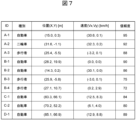
- Figure 7 shows part of the communication information regarding a target acquired by the vehicle at a certain timing.
- the target information items acquired are ID, type, position (X, Y), speed (Vx, Vy), and reliability information.
- ID “A-1” A is a unique ID representing the sender, and 1 is the ID of the target detected and output by this unique ID. Comparing ID:A-1 and ID:B-2 in Figure 7, they are both of the same type (car), and their positions differ by X (0.7 m), Y (0.1 m), and their speeds differ by Vx (0.5 km/h), Vy (0.1 km/h).
- the communication information acquisition judgment unit 5 selects the information of ID:A-1, which has a high reliability value, and does not select the information of ID:B-2, which has a low reliability value, since ID:A-1 and ID:B-2 are of the same type and have almost the same values for both position and speed (the difference between position and speed is within a specified range), and therefore are very likely to be the same target.
- ID:A-3 and ID:B-3 are compared, the two are of the same type, and the positions and velocities are almost the same (the differences in positions and velocities are within a predetermined range), so there is a high possibility that they are the same target.
- the information of ID:A-3 with a high reliability value is selected, and the information of ID:B-3 with a low reliability value is not selected.
- ID:C-1 and ID:D-1 are compared, the two are of the same type, and the positions and velocities are almost the same (the differences in positions and velocities are within a predetermined range), so there is a high possibility that they are the same target. Therefore, the information of ID:D-1 with a high reliability value is selected, and the information of ID:C-1 with a low reliability value is not selected.
- the communication information acquisition judgment unit 5 selects the one with the higher reliability of the target information.
- the difference in position and speed is used to determine whether or not the target is the same, and the threshold for the determination is, for example, that the difference between the positions X and Y is within 1 m, and that the difference between the speeds Vx and Vy is within 1 km/h.
- the threshold for the determination may be set to a different value for each type of target, and the threshold may be changed based on the distance from the vehicle (for example, the further away from the vehicle, the larger the threshold is set).
- the communication information acquisition unit 1 acquires communication information, then the communication information acquisition area setting unit 4 sets an acquisition area, and then the communication information acquired by the communication information acquisition judgment unit 5 is selected.
- the communication information acquisition area setting unit 4 may first set an acquisition area, and the communication information within the set acquisition area may be acquired by the communication information acquisition unit 1. With such a configuration, it is possible to reduce the amount of communication information acquired by the communication information acquisition unit 1 when the amount of information received by the communication device 101 is large.
- the configuration in FIG. 1 is a configuration for implementing driving assistance
- the present invention is also applicable to a configuration for implementing autonomous driving.
- autonomous driving is implemented in the configuration in FIG. 1, the driving assistance determination unit 7 is replaced with an autonomous driving determination unit.
- autonomous driving plans and controls the route to be traveled in the future at the lane level, so by feeding back detailed driving behavior (turn left at the next intersection, go right at the next fork, etc.) to the driving behavior determination unit 3 in FIG. 1, it becomes possible to efficiently set the acquisition area set by the communication information acquisition area setting unit 4.
- target object information as an example of a specific operation, but by carrying out similar processing on traffic light information, speed regulation information, lane regulation information, congestion information, road construction information, accident information, weather information, and road surface condition information other than target object information acquired by the communication information acquisition unit 1, it becomes possible to acquire only the information necessary for driving assistance, thereby preventing an increase in calculation load and memory usage, and enabling appropriate situation assessment and driving assistance to be performed.
- the communication information acquired by the communication information acquisition unit 1 is received periodically from the communication partner. Therefore, the calculation load can be reduced by calculating the distance from the vehicle from the position information (e.g., target position, traffic light position, etc.) included in the communication information, and thinning the reception interval based on the distance. That is, when the distance between the vehicle and the target information is a predetermined value or more, or the time it takes for the target information to reach the vicinity of the vehicle (a predetermined distance from the vehicle) is a predetermined value or more, the communication information acquisition unit 1 increases the reception interval (acquisition interval) of the target information to acquire distant targets by thinning them out in time.
- the position information e.g., target position, traffic light position, etc.
- the reception interval is thinned out to about 1 second (if the period is 200 ms, four times are thinned out), when the distance is 100 m or more but less than 200 m, the reception interval is thinned out to about 0.5 seconds (if the period is 200 ms, two times are thinned out), and when it is less than 100 m, reception is not thinned out.
- the control device 100a of this embodiment includes a surrounding environment recognition unit 6 that recognizes the surrounding environment of the host vehicle based on map information and on-board sensor information from a sensor (such as an on-board camera) mounted on the host vehicle, a driving assistance determination unit 7 that determines driving assistance for the host vehicle based on information from the surrounding environment recognition unit 6, a communication information acquisition unit 1 that acquires communication information transmitted from outside the host vehicle, a driving behavior determination unit 3 that determines possible driving behavior of the host vehicle based on the on-board sensor information and the map information, a communication information acquisition area setting unit 4 that sets an acquisition area for the communication information based on the driving behavior, and a communication information acquisition determination unit 5 that selects communication information that may affect the driving behavior of the host vehicle from the communication information present in the acquisition area, and the surrounding environment recognition unit 6 recognizes the surrounding environment of the host vehicle using the communication information selected by the communication information acquisition determination unit 5.
- a surrounding environment recognition unit 6 that recognizes the surrounding environment of the host vehicle based on map information and on-board sensor information from a
- the communication information acquisition area setting unit 4 sets an acquisition area for the target information included in the communication information based on the driving behavior, the communication information acquisition judgment unit 5 selects target information that is present within the acquisition area and has the potential to interfere with the driving behavior of the vehicle, and the surrounding environment recognition unit 6 recognizes the surrounding environment of the vehicle using the target information selected by the communication information acquisition judgment unit 5.
- the driving behavior determination unit 3 determines the driving behavior based on at least one of the type of road on which the vehicle is traveling, the speed limit, or lane position, a merging road or intersection where the vehicle is scheduled to travel in the future, or the vehicle speed of the vehicle.
- the communication information acquisition area setting unit 4 sets an acquisition area starting from the intersection based on the time or distance until the vehicle reaches the intersection ( Figures 3(a) and (b), 6(a) and (b)).
- the communication information acquisition area setting unit 4 sets an acquisition area starting from the junction based on the time or distance until the vehicle reaches the junction (FIGS. 4(a) and (b)).
- the communication information acquisition area setting unit 4 sets an acquisition area based on the speed of the own vehicle in the driving behavior or the speed limit of the road on which the own vehicle is traveling, it expands or reduces the acquisition area according to the speed of the own vehicle or the speed limit (setting the acquisition area wider when the speed of the own vehicle or the speed limit is high, and setting the acquisition area narrower when the speed of the own vehicle or the speed limit is low), and limits the amount of change when expanding or reducing the acquisition area.
- the communication information acquisition area setting unit 4 sets an acquisition area starting from an intersection or a junction, the communication information acquisition area setting unit 4 does not delete the set acquisition area until the vehicle passes the intersection or junction (even if there is a change in vehicle speed, etc.).
- the communication information acquisition judgment unit 5 selects target information within a predetermined range from the host vehicle within the acquisition area, selects a predetermined number of target information moving in the same direction as the host vehicle's traveling direction in front of or behind the host vehicle in order of proximity to the host vehicle, selects target information whose time or distance to reach a predetermined distance from the host vehicle (near the host vehicle) is within a predetermined value, or the selection conditions vary based on the type of target information.
- the communication information acquisition and judgment unit 5 excludes (deselects) target information that is located behind the vehicle in the traveling direction and moves in the opposite direction to the vehicle's traveling direction from the selection target, or excludes (deselects) target information of the oncoming lane from the selection target if a median strip exists between the vehicle and the oncoming lane of the road on which the vehicle is traveling.
- the communication information acquisition judgment unit 5 selects target information within a predetermined range from the intersection or the junction ( Figures 3(a), (b), 4(a), (b), 6(a), (b)).
- the communication information acquisition judgment unit 5 determines the priority of the target information based on the risk of interference with the host vehicle, and selects (stores) the target information in the order of priority, and the risk of interference is calculated based on at least one of the following: the distance between the host vehicle and the target information, the time it takes for the target information to reach a specified distance from the host vehicle (near the host vehicle), the driving lane positions of the host vehicle and the target information, or the type of the target information.
- the communication information acquisition unit 1 increases the acquisition interval (reception interval) of the target information when the distance between the vehicle and the target information is equal to or greater than a predetermined value, or when the time it takes for the target information to reach a predetermined distance from the vehicle (near the vehicle) is equal to or greater than a predetermined value.
- the communication information acquisition judgment unit 5 selects the target information with the higher reliability.
- the communication information includes at least one of the following: landmark information, traffic light information, speed regulation information, lane regulation information, traffic congestion information, road construction information, accident information, weather information, or road surface condition information.
- control device 100a of this embodiment sets an area for acquiring information through communication based on the driving behavior that the vehicle can take, selects from among the objects present in the area those that may interfere with the driving behavior of the vehicle, and outputs the selected objects to the surrounding environment recognition unit 6.
- the present invention is not limited to the above-described embodiments, but includes various modified examples and equivalent configurations within the spirit of the appended claims.
- the above-described embodiments have been described in detail to clearly explain the present invention, and the present invention is not necessarily limited to having all of the configurations described.
- part of the configuration of one embodiment may be replaced with the configuration of another embodiment.
- the configuration of another embodiment may be added to the configuration of one embodiment.
- part of the configuration of each embodiment may be added, deleted, or replaced with other configurations.
- each of the configurations, functions, processing units, processing means, etc. described above may be realized in part or in whole in hardware, for example by designing them as integrated circuits, or may be realized in software by a processor interpreting and executing a program that realizes each function.
- Information such as programs, tables, and files that realize each function can be stored in a storage device such as a memory, hard disk, or SSD (Solid State Drive), or in a recording medium such as an IC card, SD card, or DVD.
- a storage device such as a memory, hard disk, or SSD (Solid State Drive)
- a recording medium such as an IC card, SD card, or DVD.
- control lines and information lines shown are those considered necessary for explanation, and do not necessarily represent all control lines and information lines necessary for implementation. In reality, it is safe to assume that almost all components are interconnected.
Landscapes
- Physics & Mathematics (AREA)
- General Physics & Mathematics (AREA)
- Traffic Control Systems (AREA)
Abstract
通信を用いて自車周辺の情報を取得する際に、取得する情報のうち、自車の運転支援に必要な情報を削ることなく、かつ不要な情報を除外して選択することが可能な運転支援装置を提供する。車両に搭載される運転支援装置であって、地図情報と、自車に搭載されたセンサからの車載センサ情報と、に基づいて自車の周辺環境を認識する周辺環境認識部と、前記周辺環境認識部の情報に基づいて前記自車の運転支援を判断する運転支援判断部と、前記自車の外部から発信された通信情報を取得する通信情報取得部と、前記車載センサ情報および前記地図情報に基づいて前記自車の取り得る運転行動を判断する運転行動判断部と、前記運転行動に基づいて前記通信情報の取得領域を設定する通信情報取得領域設定部と、前記取得領域内に存在する前記通信情報のうち前記自車の前記運転行動に影響する可能性のある通信情報を選択する通信情報取得判断部と、を備え、前記周辺環境認識部は、前記通信情報取得判断部で選択した前記通信情報を用いて前記自車の周辺環境を認識する。
Description
本発明は、車両などの移動体において、特に通信を利用して自車周辺の情報を取得し、それらの情報を用いて運転支援を実施する運転支援装置に関する。
車載カメラやレーダなどの外界認識センサを用いて自車両周辺の物体(車両、二輪車、自転車、歩行者、構造物など)を検出するための技術が種々提案されている。また、これらの技術では外界認識センサの検出範囲が限られるため、車車間通信や路車間通信等の通信技術を用いて他の通信端末を保有する車両や路側に設置したインフラ等から自車の運転支援に必要な情報を取得し、これらの情報を用いて運転支援を実施する技術が開発されている。
上記の通信によって得られる情報は、通信端末を保有する車両や路側に設置したインフラ等がセンシングした物体の情報を含むため、非常に多くの情報が含まれる。それに対し、これらの情報を受信する自車側の運転支援装置は、使用可能なメモリ量や計算リソースに限りがあるため、すべての情報を受信することができず、必要な情報のみを受信するような仕組みが必要となる。
このような仕組みを持つ従来技術として、特許文献1がある。特許文献1には、自車の進行路に基づいて進行領域を求め、車車間通信で取得した他車両が検出した対象のうち、進行路領域内に存在する対象の情報を記憶部に記憶する車載電子制御装置が開示されている。
特許文献1に開示されている従来技術を用いることで、メモリ使用量を削減できる。しかしながら、特許文献1においては、今後の自車の予定する進行路に基づいて情報を取得する進行路領域を設定するため、次のような運転支援を実施する場合に情報が不足する可能性が高く、適切な運転支援が実施できなくなる可能性がある。例えば、運転支援として車線変更支援を実施する場合には自車後方の隣接車線の情報が必要不可欠であるが、特許文献1の進行路領域は、自車後方の領域を含まないため、車線変更支援を適切に実行することが難しい。また、例えば、運転支援として交差点において直交してくる車両(直交車)に対して自動緊急ブレーキを実施する場合には車速が高い直交車ほど遠方に位置している状態からの情報が必要不可欠であるが、特許文献1の進行路領域は、交差点においては自車の予定する進行路方向の領域をとり、他の交差方向の道路は領域に含まれないため、自動緊急ブレーキを適切に実行することが難しい。
本発明は、前述した事情を鑑みてなされたもので、通信を用いて自車周辺の情報を取得する際に、取得する情報のうち、自車の運転支援に必要な情報を削ることなく、かつ不要な情報を除外して選択することが可能な運転支援装置を提供することを目的とする。
本願において開示される発明の代表的な一例を示せば以下の通りである。すなわち、車両に搭載される運転支援装置であって、地図情報と、自車に搭載されたセンサからの車載センサ情報と、に基づいて自車の周辺環境を認識する周辺環境認識部と、前記周辺環境認識部の情報に基づいて前記自車の運転支援を判断する運転支援判断部と、前記自車の外部から発信された通信情報を取得する通信情報取得部と、前記車載センサ情報および前記地図情報に基づいて前記自車の取り得る運転行動を判断する運転行動判断部と、前記運転行動に基づいて前記通信情報の取得領域を設定する通信情報取得領域設定部と、前記取得領域内に存在する前記通信情報のうち前記自車の前記運転行動に影響する可能性のある通信情報を選択する通信情報取得判断部と、を備え、前記周辺環境認識部は、前記通信情報取得判断部で選択した前記通信情報を用いて前記自車の周辺環境を認識することを特徴とする。
本発明の一態様によれば、通信によって得られる情報から運転支援に必要となる情報のみを取り込むことで計算負荷やメモリ使用量の増大を防ぐことができ、適切な状況判断と運転支援を実行することが可能になる。
前述した以外の課題、構成及び効果は、以下の実施例の説明によって明らかにされる。
以下、本発明の実施例について図面を用いて説明する。
図1は、本発明の一実施例による運転支援装置の概略構成図である。図1に例示される運転支援装置としての制御装置100aは、自車両を制御するコンピュータであり、不図示の記憶媒体に記憶されたプログラムを実行することによって、通信情報取得部1、地図情報取得部2、運転行動判断部3、通信情報取得領域設定部4、通信情報取得判断部5、周辺環境認識部6、運転支援判断部7、車両制御部8、HMI制御部9として機能する。
制御装置100aは、自車両の操舵装置111、駆動装置112、制動装置113、及び変速装置114と、自車両に設けられた通信装置101、外環境認識装置102、音発生装置115、表示装置116とに接続されている。また、制御装置100aは、自車両のCAN(不図示)や専用線などの伝送路に接続されており、これらの伝送路を経由して自車両の車速、舵角、シフト位置などの車両情報及びスイッチ入力、タッチパネル入力などのユーザ操作情報が入力される。
通信装置101は、Wi-Fi(IEEE802.11)や4G、5G等の無線通信方式を用いて車外と通信し、自車両の運転支援に必要な情報を受信する。車外との通信相手は、他車両に搭載された通信装置、路側に設置された各種インフラ(信号機、ETCゲート、専用設備等)の通信装置、人等が保持している携帯電話、データセンタ(複数の情報を蓄積して必要な情報を送信する設備)等であり、自車両が受信する情報は、物標情報(通信相手そのものの情報、通信相手がセンシングした情報等)、信号機情報(現在の信号色、信号色が他の色に切り替わるまでの時間等)、速度規制情報(規制速度、規制区間等)、車線規制情報(規制車線、規制区間等)、渋滞情報(渋滞区間、渋滞末尾位置等)、道路工事情報(工事位置、規制内容等)、事故情報(事故位置、規制内容等)、天候情報(天候内容、区間情報等)、路面状態情報(路面状態、区間/位置情報等)である。また、物標情報としては、物標の種別(普通車、大型車、緊急車両、二輪車、自転車、人、その他識別不明なもの等)、位置、速度、移動方向、信頼度(情報を信頼できる度合いで、例えば1~100の数値で100が最も信頼できる値とする)等である。
外環境認識装置102は、自車両の周囲環境に関する情報を取得する装置であって、例えば、車両周囲環境を撮影する単眼カメラやステレオカメラなどの車載カメラである。車載カメラにより得られた画像は、アナログデータのまま、又はA/D変換して、専用線などの伝送路を経由して制御装置100aに出力される。また、車載カメラ以外にもミリ波やレーザー光を用いて物体との距離を計測するレーダ、超音波を用いて物体との距離を計測するソナー等を用いることができる。車載カメラなどのこれらの装置は、検出した物体との距離とその方角、速度や物体の種別等の情報を専用線などの伝送路を経由して制御装置100aに出力する構成としても良い。
操舵装置111は、外部からの駆動指令により電動や油圧のアクチュエータなどによって舵角を制御できる電動パワーステアリング、油圧パワーステアリング等で構成される。
駆動装置112は、外部からの駆動指令により電動のスロットルなどでエンジントルクを制御できるエンジンシステムや、外部からの駆動指令によりモータなどの駆動力を制御できる電動パワートレインシステム等で構成される。
制動装置113は、外部からの制動指令により電動や油圧のアクチュエータなどで制動力を制御できる電動ブレーキや油圧ブレーキ等で構成される。
変速装置114は、外部からの変速指令により電動や油圧のアクチュエータなどで前進や後退を切り替え可能なトランスミッション等で構成される。
音発生装置115は、スピーカー等で構成され、運転者に対する警報や音声ガイダンス等を出力する情報報知部として機能する。
表示装置116は、ナビゲーション装置等のディスプレイ、メーターパネル、警告灯等で構成される。表示装置116は、制御装置100aの操作画面や、自車両が障害物に衝突する危険があることなどを運転者に視覚的に伝える警告画面等の情報を報知する情報報知部として機能する。
通信情報取得部1は、通信装置101で受信した(自車両の外部から発信された)自車両の運転支援に必要な情報(通信情報)を取得する。
地図情報取得部2は、自車両周辺の地図情報を取得する。取得される地図情報は、ポリゴンやポリライン等で表現される実際の道路形状に近い形状データや、通行規制情報(制限速度、通行可能車両種別等)、車線区分(本線、追越車線、登坂車線、直進車線、左折車線、右折車線等)とその区画線の種別や位置、信号機や標識等の有無(有の場合はその位置情報)等の情報である。
運転行動判断部3は、外環境認識装置102で認識した自車両の周囲環境に関する情報と地図情報取得部2により取得した自車両周辺の地図情報を用いて自車両の取り得る運転行動を判断する。自車両の運転行動とは具体的には、自車両が走行中の道路の種別(自動車専用道路、一般道路等)や制限速度、自車両が走行している車線位置、自車両が今後走行する予定の交差点や合流路の形状やそこまでの距離、自車両の現在の車速等を用いて、例えば、片側2車線の制限速度50km/hの一般道の右車線を45km/hで走行しており、100m先の十字路交差点に進入しようとしている、といった内容となる。他には、自動車専用道路につながる1車線の制限速度40km/hの接続道路を38km/hで走行しており、150m先の合流路から本線に合流しようとしている、といった内容等がある。
通信情報取得領域設定部4は、運転行動判断部3により判断された自車両の取り得る運転行動に基づいて通信情報取得部1で取得した情報(通信情報)を選択する領域(取得領域)を設定する。例えば、自車両の運転行動が十字路交差点に進入しようとしている場合は、自車が走行している道路に加えて交差道路も取得領域として設定する。また、自車の運転行動が合流路に進入しようとしている場合は、自車が走行している接続路に加えて合流部分の前後の本線車線も取得領域として設定する。
通信情報取得判断部5は、通信情報取得領域設定部4により設定された領域内の情報のうち、運転行動判断部3により判断された自車両の取り得る運転行動に影響する可能性のある情報を選択する。例えば、自車両の運転行動が十字路交差点に進入しようとしている場合は、交差道路を交差点方向に走行している車両や、交差点の横断歩道を歩行中の人や、自車が走行している方向の信号機の色情報等を選択する。
周辺環境認識部6は、外環境認識装置102から入力された情報、地図情報取得部2により取得した地図情報、通信情報取得判断部5により選択された通信情報を用いて、自車両周辺の障害物や車両が走行可能なフリースペースを検出する。障害物に関しては、種別や位置、移動方向や移動速度等を検出する。障害物の種別としては、普通車や大型車、緊急車両等の車両、二輪車、自転車、歩行者、ガードレール、縁石、壁、フェンス、植栽、落下物などである。障害物の種別や位置は、既知の技術であるパターンマッチングによって検出する方法を用いることができるが、他の技術を用いて検出してもよい。フリースペースに関しては、区画線や路端、車両が走行可能な路面情報、障害物情報等を用いて、車両が走行可能な領域情報として検出する。
運転支援判断部7は、周辺環境認識部6の出力に基づいて適切な運転支援を判断する。運転支援の内容としては、例えば、障害物との衝突を予測して警報や制動を実施する自動緊急ブレーキ、隣接車線の車両との位置関係を考慮して適切なタイミングで車線変更の実施を支援する車線変更/合流支援、前方の低速車を対向車線にはみ出しての追い越しを支援する低速車追越支援、信号機の現在の色や今後の色の移り変わりの情報から信号機のある場所の通過を支援する信号機通過支援等がある。
車両制御部8は、運転支援判断部7で判断された運転支援の内容に基づき、自車両の走行を制御する。例えば、車線変更/合流支援として、隣接車線への操舵アシストと速度調節を行う場合、車両制御部8は、状況に応じた目標舵角と目標速度を演算する。そして、車両制御部8は、その目標舵角を実現するための目標操舵トルクを操舵装置111へ出力する。また、車両制御部8は、目標速度を実現するための目標エンジントルクや目標ブレーキ圧を駆動装置112や制動装置113へ出力する。さらに別の運転支援において、自車両の進行方向を変更する必要がある場合、変速指令を変速装置114に出力する。
HMI制御部9は、運転支援判断部7で判断された運転支援の内容に基づき、ユーザに報知するための情報を状況に応じて適宜生成し、音発生装置115および表示装置116に出力する。例えば、自動緊急ブレーキの警報を出力する場合、音発生装置115および表示装置116のそれぞれに自動緊急ブレーキ警報の出力信号を送信する。
次に、フローチャートを用いて制御装置100aの処理手順を説明する。
図2は、制御装置100aの処理手順の一例を示すフローチャートである。
図2の処理S201では、制御装置100aは、通信装置101から通信により受信した通信情報を取得する。
処理S202では、制御装置100aは、外環境認識装置102から外界環境の認識結果を取得する。
処理S203では、自車両の車速、舵角、シフト位置などの車両情報を取得する。
処理S204では、自車両周辺の地図情報を取得する。
処理S205では、処理S202で取得した外界環境認識結果と処理S204で取得した地図情報に基づいて、自車両の運転行動を判断する。
処理S206では、処理S205で判断した運転行動に基づいて処理S201で取得した通信情報を選択する取得領域を設定する。
処理S207では、処理S206で設定した取得領域内の情報のうち、処理S205で判断した運転行動に影響する可能性のある情報を選択する。
処理S208では、処理S201で取得した通信情報、処理S204で取得した地図情報、処理S207で選択された通信情報を用いて、自車両周辺の障害物や車両が走行可能なフリースペースを検出する。
処理S209では、処理S208の出力に基づいて適切な運転支援を判断する。
処理S210では、処理S209で判断した運転支援の内容に基づき、自車両の走行を制御する。また、ユーザに報知する情報を出力し、一連の処理を終了する。
以上説明したフローを実行することで、通信によって得られる情報から運転支援に必要となる情報のみを取り込むことで計算負荷やメモリ使用量の増大を防ぐことができ、適切な状況判断と運転支援を実行することが可能になる。
次に、図3(a)から図6(b)を用いて、具体的な動作について説明する。
図3(a)、(b)は、自車両300が交差点に向かって走行している状況を想定している。ここで、自車両300以外の車両、歩行者、自転車はすべて通信情報取得部1により取得されている情報とする。
図3(a)は、自車両300から交差点までの距離Xcが十分離れている場合であり、自車両300は片側1車線道路を図中の左の方向に向かっている状況である。このときの自車両300の運転行動は、「片側1車線道路を走行」であり、これ以外の取り得る運転行動としては、何かを避けるためにもしくは低速車を追い越すために対向車線にはみ出す、対向車線を横切って商用施設駐車場等に入る、左折して歩道を横切って商用施設駐車場等に入る、左の歩道に車を寄せて停車する、といった内容等が考えられる。これらの運転行動を考慮して通信情報取得領域設定部4により破線領域301を取得領域として設定する。この領域の大きさとして、自車両300の左方向の幅Wlは左側の歩道の領域までをカバーできる範囲を、右方向の幅Wrは右側の歩道の領域までをカバーできる範囲を、前方向の長さLfは対向車との正面衝突を回避できる範囲を、後方向の長さLrは後続車との衝突を回避できる範囲を設定する。WlとWrについては、歩道の幅が地図情報から取得できればその値を利用し、地図情報から取得できない(地図情報に歩道の情報がない場合を含む)場合は外環境認識装置102により認識された情報に基づいて歩道の幅を算出するか、車道の境界から所定の幅(例えば5m)を歩道の幅として利用する。Lfについては、地図情報の制限速度の情報もしくは自車両の速度の情報を用いて対向車と自車両の相対速度が最大となる値を求め、例えば自動緊急ブレーキの警報を実施するタイミングを考慮して算出する。具体的には、制限速度が50km/hの場合は相対速度の最大値は100km/h(自車両と対向車ともに50km/h)であり、自動緊急ブレーキの警報を実施するタイミングが衝突までの予測時間3秒の場合、Lf=100÷3.6×3≒83[m]となるが、制限速度以上での走行の可能性もあるために相対速度の最大値を少し大きめにして算出してもよい。Lrについては、Lfと同様に、地図情報の制限速度の情報もしくは自車両の速度の情報を用いて後続車と自車両の相対速度が最大となる値を求め、例えば自動緊急ブレーキの警報を実施するタイミングを考慮して算出する。具体的には、制限速度が50km/hの場合は相対速度の最大値は50km/h(自車両は停車、後続車は50km/h)であり、自動緊急ブレーキの警報を実施するタイミングが衝突までの予測時間3秒の場合、Lr=50÷3.6×3≒42[m]となるが、制限速度以上での走行の可能性もあるために相対速度の最大値を少し大きめにして算出してもよい。なお、走行中の道路の制限速度が変化する場合は、その変化地点でLfが急変し、範囲の境界での物標情報の出入りも急変する。そのため、このように運転行動の自車両の速度または自車両が走行中の道路の制限速度に基づいて取得領域を設定する場合において、自車両の速度または制限速度が高い時は取得領域を広く設定し、自車両の速度または制限速度が低い時は取得領域を狭く設定するものとし(言い換えると、自車両の速度または制限速度に応じて取得領域を拡大または縮小するものとし)、取得領域を拡大または縮小する場合においては、その変化量に時間的もしくは距離的に制限をかけることで急変を抑えることが可能となる。
次に、通信情報取得判断部5により破線領域301内の物標情報のうち、自車両300の運転行動に対して干渉する可能性のある物標情報を選択する(図3(a)の中で選択した物標に〇印、非選択の物標に×印をつけている)。自車両300の近傍に存在する物標に関しては、自車両300の運転行動の急な変化や物標の急な動きの変化の可能性を考慮して、自車両300から所定範囲内(例えば10m以内)の物標情報はすべて選択する。自車両300の前方に存在する物標に関しては、自車両300の進行方向に存在する物標のため、基本的にはすべての物標を選択するが、自車両300と同一方向に移動しておりかつ自車両300から遠い物標(例えばLf/2より遠方)は自車両300との干渉リスクが小さいと判断して非選択としてもよく、同様に自車両300に接近してきておりかつ自車両300に到達するまでの予測時間が長い物標(例えば予測時間3秒以上)も自車両300との干渉リスクが小さいと判断して非選択としてもよい。言い換えると、自車両近傍(自車両から所定距離)に到達するまでの時間または距離が所定値以内の物標を選択してもよい。自車両300の後方に存在する物標に関しては、自車両300と同一方向に移動している物標は基本的にはすべて選択するが、物標種別が人の場合は非選択とする(人は自車両300の近傍で選択している分で十分なため)。言い換えると、物標種別に基づいて選択する条件を変更してもよい。また、自車両300の進行方向に対して後方でかつ自車両300から離れていく方向(自車両300の進行方向に対して逆方向)に移動している物標(対向車線の車両等)は自車両300と干渉する可能性はないために非選択とする。
図3(b)は、図3(a)の状況から自車両300が交差点に近づいて交差点までの距離Xcが所定値以内となった状況である。このときの自車両300の運転行動は、「片側1車線道路を走行、かつ十字路交差点に進入しようとしている」であり、図3(a)での内容に、十字路交差点を直進/右折/左折する、といった内容等が追加で考えられる。これらの運転行動を考慮して通信情報取得領域設定部4により図3(a)の破線領域301と同等の破線領域302に加えて一点鎖線領域303を取得領域として設定する。破線領域302の設定方法は破線領域301と同じであり、一点鎖線領域303の大きさとして、交差道路の幅Wcは両側の歩道の領域までをカバーできる範囲を、交差道路の長さLcは交差車両との衝突を回避できる範囲を設定する。Wcについては、歩道の幅が地図情報から取得できればその値を利用し、地図情報から取得できない(地図情報に歩道の情報がない場合を含む)場合は外環境認識装置102により認識された情報に基づいて歩道の幅を算出するか、車道の境界から所定の幅(例えば5m)を歩道の幅として利用する。Lcについては、地図情報の制限速度の情報を用いて交差車両の速度が最大となる値を求め、例えば自動緊急ブレーキの警報を実施するタイミングを考慮して算出する。具体的には、制限速度が50km/hの場合は交差車両の速度の最大値も50km/hであり、自動緊急ブレーキの警報を実施するタイミングが衝突までの予測時間3秒の場合、自車両300が走行している道路幅を6mとすると、Lc=(50÷3.6×3)×2+6≒89[m]となるが、制限速度以上での走行の可能性もあるために相対速度の最大値を少し大きめにして算出してもよい。なお、一点鎖線領域303を設定するタイミングとして自車両300から交差点までの距離Xcが所定値以内としているが、この所定値の設定方法としては固定値(例えば100m)としてもよいが、自車両300が交差点に到達するまでの時間を設定して(例えば3秒)この時間と自車両300の車速をかけて求めた距離を所定値としても良く、後者のようにすることでより適切なタイミングで一点鎖線領域303の設定が可能となる。ただし、この場合、一旦一点鎖線領域303を設定後に自車両300の車速が小さくなると上記の所定値が小さくなるために一点鎖線領域303を設定する条件から外れてしまう。一旦一点鎖線領域303を設定後に一点鎖線領域303を削除すると一点鎖線領域303内で選択した物標情報も一旦なくなってしまうことから情報の出入りが激しくなり非効率である。そのため、交差点領域の一点鎖線領域303を設定後は自車両300がその交差点を通過するまでは設定された一点鎖線領域303を削除しないことが望ましい。
次に、通信情報取得判断部5により破線領域302内および一点鎖線領域303内の物標情報のうち、自車両300の運転行動に対して干渉する可能性のある物標情報を選択する(図3(b)の中で選択した物標に〇印、非選択の物標に×印をつけている)。破線領域302内の選択方法は図3(a)で説明した方法と同じである。一点鎖線領域303内の選択方法は次の通りである。交差点を起点とする領域(例えば破線領域302と一点鎖線領域303の重なっている領域)に存在する物標に関しては、自車両300の運転行動に干渉する可能性が高いためにすべて選択する。交差点に進入してくる物標に関しては、基本的にはすべての物標を選択するが、交差点に到達するまでの予測時間が長い物標(例えば予測時間3秒以上)は自車両300との干渉リスクが小さいと判断して非選択としてもよい。言い換えると、交差点から所定範囲内の物標を選択してもよい。交差点から離れていく物標に関しては、自車両300と干渉する可能性はないために非選択とする。
図4(a)、(b)は、自車両400が自動車専用道路の合流地点に向かってその接続道路(歩道なし)を走行している状況を想定している。ここで、自車両400以外の車両はすべて通信情報取得部1により取得されている情報とする。
図4(a)は、自車両400から合流開始点までの距離Xmが十分離れている場合であり、自車両400は1車線の接続道路を合流開始地点に向かっている状況である。このときの自車両400の運転行動は、「1車線の接続道路を走行」であり、これ以外の取り得る運転行動としては、先行車の状況に合わせて減速/加速/停車する、といった内容等が考えられる。これらの運転行動を考慮して通信情報取得領域設定部4により破線領域401を取得領域として設定する。この領域の大きさとして、前方向の長さは先行車との衝突を回避できる範囲を、後方向の長さは後続車との衝突を回避できる範囲を、幅はこの接続道路には歩道がないために道幅分の範囲をそれぞれ設定する。前方向の長さについては、地図情報の制限速度の情報もしくは自車両の速度の情報を用いて先行車と自車両の相対速度が最大となる値を求め、例えば自動緊急ブレーキの警報を実施するタイミングを考慮して算出する。具体的には、制限速度が50km/hの場合は相対速度の最大値は50km/h(自車両は50km/h、先行車は停車)であり、自動緊急ブレーキの警報を実施するタイミングが衝突までの予測時間3秒の場合、Lf=50÷3.6×3≒42[m]となるが、制限速度以上での走行の可能性もあるために相対速度の最大値を少し大きめにして算出してもよい。後方向の長さについては、前方向の長さと同様に、地図情報の制限速度の情報もしくは自車両の速度の情報を用いて後続車と自車両の相対速度が最大となる値を求め、例えば自動緊急ブレーキの警報を実施するタイミングを考慮して算出する。具体的には、制限速度が50km/hの場合は相対速度の最大値は50km/h(自車両は停車、後続車は50km/h)であり、自動緊急ブレーキの警報を実施するタイミングが衝突までの予測時間3秒の場合、Lr=50÷3.6×3≒42[m]となるが、制限速度以上での走行の可能性もあるために相対速度の最大値を少し大きめにして算出してもよい。なお、走行中の道路の制限速度が変化する場合は、その変化地点でLfが急変し、範囲の境界での物標情報の出入りも急変する。そのため、このように運転行動の自車両の速度または自車両が走行中の道路の制限速度に基づいて取得領域を設定する場合において、自車両の速度または制限速度が高い時は取得領域を広く設定し、自車両の速度または制限速度が低い時は取得領域を狭く設定するものとし(言い換えると、自車両の速度または制限速度に応じて取得領域を拡大または縮小するものとし)、取得領域を拡大または縮小する場合においては、その変化量に時間的もしくは距離的に制限をかけることで急変を抑えることが可能となる。
次に、通信情報取得判断部5により破線領域401内の物標情報のうち、自車両400の運転行動に対して干渉する可能性のある物標情報を選択する(図4(a)の中で選択した物標に〇印、非選択の物標に×印をつけている)。自車両400の前方に存在する物標に関しては、自車両400の進行方向に存在する物標のため、基本的にはすべての物標を選択するが、自車両400の前方に複数台の車両が並んでいる場合は所定台数より先(例えば3台目より先)は自車両400との干渉リスクが小さいと判断して非選択としてもよい。同様に、自車両400の後方に存在する物標に関しては、自車両400と同一方向に移動する物標のため、基本的にはすべての物標を選択するが、自車両400の後方に複数台の車両が並んでいる場合は所定台数より後ろ(例えば3台目より後ろ)は自車両400との干渉リスクが小さいと判断して非選択としてもよい。言い換えると、自車両400の前後を自車両400の進行方向と同方向に移動する物標において自車両400から近い順に所定個数(例えば前後2台目まで)を選択してもよい。
図4(b)は、図4(a)の状況から自車両400が合流地点に近づいて合流開始地点までの距離Xmが所定値以内となった状況である。この時の自車両400の運転行動は、「1車線の接続道路を走行、かつ合流路から本線に合流しようとしている」であり、図4(a)での内容に、合流路から車線変更して本線に合流する、合流路から本線に合流できずに合流路で停車する、といった内容等が追加で考えられる。これらの運転行動を考慮して通信情報取得領域設定部4により図4(a)の破線領域401と同等の破線領域402に加えて一点鎖線領域403を取得領域として設定する。破線領域402の設定方法は破線領域401とほぼ同じであるが、前方の領域が合流開始地点を越えているために合流開始地点以降は本線も含む領域を設定している。一点鎖線領域403の大きさとしては、幅は本線道路の道路幅をカバーできる範囲を、長さLmは自車両400が本線を走行する車両との衝突を回避しつつ車線変更するために必要な範囲を設定する。Lmについては、地図情報から取得可能な本線との合流路(合流開始地点から合流終了地点)の長さ(地図情報から取得できない場合は固定値、例えば200mとする)に加えて、地図情報の本線制限速度等を用いて合流開始地点より手前側の範囲を含めるものとする。具体的には、合流開始地点より手前側の範囲は、本線制限速度に比例した長さにする方法や、本線制限速度に基づいたテーブルから参照する方法等がある。例えば前者を用いる場合は、長さ[m]=本線制限速度[km/h]×比例定数、と表すことができ、本線制限速度100km/h、比例定数1.5の時は、長さは150mとなり、地図情報から取得した合流路の長さが180mの場合はLm=180+150=330[m]となる。なお、一点鎖線領域403を設定するタイミングとして自車両400から合流開始地点までの距離Xmが所定値以内としているが、この所定値の設定方法としては固定値(例えば100m)としてもよいが、自車両400が合流開始地点に到達するまでの時間を設定して(例えば3秒)この時間と自車両400の車速をかけて求めた距離を所定値としても良く、後者のようにすることでより適切なタイミングで一点鎖線領域403の設定が可能となる。ただし、この場合、一旦一点鎖線領域403を設定後に自車両400の車速が小さくなると上記の所定値が小さくなるために一点鎖線領域403を設定する条件から外れてしまう。一旦一点鎖線領域403を設定後に一点鎖線領域403を削除すると一点鎖線領域403内で選択した物標情報も一旦なくなってしまうことから情報の出入りが激しくなり非効率である。そのため、本線領域の一点鎖線領域403を設定後は自車両400が合流地点を通過するまでは設定された一点鎖線領域403を削除しないことが望ましい。
次に、通信情報取得判断部5により破線領域402内および一点鎖線領域403内の物標情報のうち、自車両400の運転行動に対して干渉する可能性のある物標情報を選択する(図4(b)の中で選択した物標に〇印、非選択の物標に×印をつけている)。破線領域402内の選択方法は図4(a)で説明した方法と同じである。一点鎖線領域403内の選択方法としては、本線の走行車線(左車線)を走行している車両は合流する際に直接影響があり、追越車線(右車線)を走行している車両も走行車線に車線変更してくる可能性があるため、基本的にはすべての物標を選択するが、本線車線が渋滞しているなどで本線の走行速度が遅い場合はすべての物標を選択すると非効率になる場合があるため、例えば合流開始地点に到達するまでの予測時間が長い物標(例えば予測時間3秒以上)は自車両400との干渉リスクが小さいと判断して非選択としてもよい。言い換えると、合流地点から所定範囲内の物標を選択してもよい。
図5(a)、(b)は、自車両500が中央分離帯510で対向車線と物理的に仕切られている片側2車線の自動車専用道路の走行車線(左車線)を走行している状況を想定している。ここで、自車両500以外の車両はすべて通信情報取得部1により取得されている情報とする。
図5(a)、(b)ともに、このときの自車両500の運転行動は、「2車線の自動車専用道路の走行車線を走行」であり、これ以外の取り得る運転行動としては、追越車線に車線変更する、先行車の状況に合わせて減速/加速/停車する、といった内容等が考えられる。これらの運転行動を考慮して通信情報取得領域設定部4により破線領域501を取得領域として設定する。この領域の大きさとして、前方向の長さLfは先行車との衝突を回避できる範囲を、後方向の長さLrは後続車との衝突を回避できる範囲を、幅に関しては対向車線が物理的に中央分離帯510で仕切られているために、対向車線を含まず、自車両500が走行している2車線の道幅分のみの範囲をそれぞれ設定する。前方向の長さLfについては、地図情報の制限速度の情報もしくは自車両の速度の情報を用いて先行車と自車両の相対速度が最大となる値を求め、例えば自動緊急ブレーキの警報を実施するタイミングを考慮して算出する。具体的には、制限速度が100km/hの場合は相対速度の最大値は100km/h(自車両は100km/h、先行車は停車)であり、自動緊急ブレーキの警報を実施するタイミングが衝突までの予測時間3秒の場合、Lf=100÷3.6×3≒83[m]となるが、制限速度以上での走行の可能性もあるために相対速度の最大値を少し大きめにして算出してもよい。後方向の長さLrについては、前方向の長さLfと同様に、地図情報の制限速度の情報もしくは自車両の速度の情報を用いて後続車と自車両の相対速度が最大となる値を求め、例えば自動緊急ブレーキの警報を実施するタイミングを考慮して算出する。具体的には、制限速度が100km/hの場合は相対速度の最大値は100km/h(自車両は停車、後続車は100km/h)であり、自動緊急ブレーキの警報を実施するタイミングが衝突までの予測時間3秒の場合、Lr=100÷3.6×3≒83[m]となるが、制限速度以上での走行の可能性もあるために相対速度の最大値を少し大きめにして算出してもよい。なお、走行中の道路の制限速度が変化する場合は、その変化地点でLfが急変し、範囲の境界での物標情報の出入りも急変する。そのため、このように運転行動の自車両の速度または自車両が走行中の道路の制限速度に基づいて取得領域を設定する場合において、自車両の速度または制限速度が高い時は取得領域を広く設定し、自車両の速度または制限速度が低い時は取得領域を狭く設定するものとし(言い換えると、自車両の速度または制限速度に応じて取得領域を拡大または縮小するものとし)、取得領域を拡大または縮小する場合においては、その変化量に時間的もしくは距離的に制限をかけることで急変を抑えることが可能となる。
次に、通信情報取得判断部5により破線領域501内の物標情報のうち、自車両500の運転行動に干渉する可能性のある物標情報を選択する(図5(a)、(b)の中で選択した物標に〇印、非選択の物標に×印をつけている)。自車両500の前方に存在する物標に関しては、自車両500の進行方向に存在する物標のため、図5(a)に示すように基本的にはすべての物標を選択するが、自車両500の前方に複数台の車両が並んでいる場合は図5(b)に示すように所定台数より先(例えば3台目より先)は自車両500との干渉リスクが小さいと判断して非選択としてもよい。同様に、自車両500の後方に存在する物標に関しては、自車両500と同一方向に移動する物標のため、図5(a)に示すように基本的にはすべての物標を選択するが、自車両500の後方に複数台の車両が並んでいる場合は図5(b)に示すように所定台数より後ろ(例えば3台目より後ろ)は自車両500との干渉リスクが小さいと判断して非選択としてもよい。言い換えると、自車両500の前後を自車両500の進行方向と同方向に移動する物標において自車両500から近い順に所定個数(例えば前後2台目まで)を選択してもよい。また、前述のように、自車両500が走行している道路の対向車線との間に中央分離帯510が存在する場合において、破線領域501の幅に関しては、対向車線を含まず、自車両500が走行している2車線の道幅分のみの範囲に設定されているため、対向車線の物標は非選択(選択対象外)となる。
図6(a)、(b)は、自車両600が片側2車線道路の左車線を交差点に向かって走行している状況を想定している。ここで、自車両600以外の車両、歩行者、自転車はすべて通信情報取得部1により取得されている情報とする。
図6(a)は、自車両600から交差点までの距離Xcが十分離れている場合であり、自車両600は片側2車線道路の左車線を図中の左の方向に向かっている状況である。このときの自車両600の運転行動は、「片側2車線道路の左車線を走行」であり、これ以外の取り得る運転行動としては、右車線に車線変更する、左折して歩道を横切って商用施設駐車場等に入る、左の歩道に車を寄せて停車する、といった内容等が考えられる。これらの運転行動を考慮して通信情報取得領域設定部4により破線領域601を取得領域として設定する。この領域の大きさとして、自車両600の左方向の幅Wlは左側の歩道の領域までをカバーできる範囲を、右方向の幅Wrは右側の歩道の領域までをカバーできる範囲を、前方向の長さLfは対向車との正面衝突を回避できる範囲を、後方向の長さLrは後続車との衝突を回避できる範囲を設定する。WlとWrについては、歩道の幅が地図情報から取得できればその値を利用し、地図情報から取得できない(地図情報に歩道の情報がない場合を含む)場合は外環境認識装置102により認識された情報に基づいて歩道の幅を算出するか、車道の境界から所定の幅(例えば5m)を歩道の幅として利用する。Lfについては、地図情報の制限速度の情報もしくは自車両の速度の情報を用いて対向車と自車両の相対速度が最大となる値を求め、例えば自動緊急ブレーキの警報を実施するタイミングを考慮して算出する。具体的には、制限速度が50km/hの場合は相対速度の最大値は100km/h(自車両と対向車ともに50km/h)であり、自動緊急ブレーキの警報を実施するタイミングが衝突までの予測時間3秒の場合、Lf=100÷3.6×3≒83[m]となるが、制限速度以上での走行の可能性もあるために相対速度の最大値を少し大きめにして算出してもよい。Lrについては、Lfと同様に、地図情報の制限速度の情報もしくは自車両の速度の情報を用いて後続車と自車両の相対速度が最大となる値を求め、例えば自動緊急ブレーキの警報を実施するタイミングを考慮して算出する。具体的には、制限速度が50km/hの場合は相対速度の最大値は50km/h(自車両は停車、後続車は50km/h)であり、自動緊急ブレーキの警報を実施するタイミングが衝突までの予測時間3秒の場合、Lr=50÷3.6×3≒42[m]となるが、制限速度以上での走行の可能性もあるために相対速度の最大値を少し大きめにして算出してもよい。なお、走行中の道路の制限速度が変化する場合は、その変化地点でLfが急変し、範囲の境界での物標情報の出入りも急変する。そのため、このように運転行動の自車両の速度または自車両が走行中の道路の制限速度に基づいて取得領域を設定する場合において、自車両の速度または制限速度が高い時は取得領域を広く設定し、自車両の速度または制限速度が低い時は取得領域を狭く設定するものとし(言い換えると、自車両の速度または制限速度に応じて取得領域を拡大または縮小するものとし)、取得領域を拡大または縮小する場合においては、その変化量に時間的もしくは距離的に制限をかけることで急変を抑えることが可能となる。
次に、通信情報取得判断部5により破線領域601内の物標情報のうち、自車両600の運転行動に対して干渉する可能性のある物標情報を選択する(図6(a)の中で選択した物標に〇印、非選択の物標に×印をつけている)。自車両600の近傍に存在する物標に関しては、自車両600の運転行動の急な変化や物標の急な動きの変化の可能性を考慮して、自車両600から所定範囲内(例えば10m以内)の物標情報はすべて選択する。自車両600の前方に複数台の車両が並んでいる場合は所定台数より先(例えば3台目より先)は自車両600との干渉リスクが小さいと判断して非選択としてもよく、自車両600の2車線隣の車線より遠方(対向車線の左車線とその向こうの歩道)も自車両600との干渉リスクが小さいと判断して非選択としてもよい。自車両600の後方に存在する物標に関しては、自車両600と同一方向に移動している物標は基本的にはすべて選択するが、物標種別が人の場合は非選択とする(人は自車両600の近傍で選択している分で十分なため)。また、自車両600の進行方向に対して後方でかつ自車両600から離れていく方向(自車両600の進行方向に対して逆方向)に移動している物標(対向車線の車両等)は自車両600と干渉する可能性はないために非選択とする。
図6(b)は、図6(a)の状況から自車両600が交差点に近づいて交差点までの距離Xcが所定値以内となった状況である。このときの自車両600の運転行動は、「片側2車線道路の左車線を走行、かつ十字路交差点に進入しようとしている」であり、図6(a)での内容に、十字路交差点を直進/左折する(左車線からは右折が禁止されている道路とする)、といった内容等が追加で考えられる。これらの運転行動を考慮して通信情報取得領域設定部4により図6(a)の破線領域601と同等の破線領域602に加えて一点鎖線領域603を取得領域として設定する。破線領域602の設定方法は破線領域601と同じであり、一点鎖線領域603の大きさとして、交差道路の幅Wcは両側の歩道の領域までをカバーできる範囲を、交差道路の長さLcは交差車両との衝突を回避できる範囲を設定する。Wcについては、歩道の幅が地図情報から取得できればその値を利用し、地図情報から取得できない(地図情報に歩道の情報がない場合を含む)場合は外環境認識装置102により認識された情報に基づいて歩道の幅を算出するか、車道の境界から所定の幅(例えば5m)を歩道の幅として利用する。Lcについては、地図情報の制限速度の情報を用いて交差車両の速度が最大となる値を求め、例えば自動緊急ブレーキの警報を実施するタイミングを考慮して算出する。具体的には、制限速度が50km/hの場合は交差車両の速度の最大値も50km/hであり、自動緊急ブレーキの警報を実施するタイミングが衝突までの予測時間3秒の場合、自車両600が走行している道路幅を6mとすると、Lc=(50÷3.6×3)×2+6≒89[m]となるが、制限速度以上での走行の可能性もあるために相対速度の最大値を少し大きめにして算出してもよい。なお、一点鎖線領域603を設定するタイミングとして自車両600から交差点までの距離Xcが所定値以内としているが、この所定値の設定方法としては固定値(例えば100m)としてもよいが、自車両600が交差点に到達するまでの時間を設定して(例えば3秒)この時間と自車両600の車速をかけて求めた距離を所定値としても良く、後者のようにすることでより適切なタイミングで一点鎖線領域603の設定が可能となる。
次に、通信情報取得判断部5により破線領域602内および一点鎖線領域603内の物標情報のうち、自車両600の運転行動に対して干渉する可能性のある物標情報を選択する(図6(b)の中で選択した物標に〇印、非選択の物標に×印をつけている)。破線領域602内の選択方法は図6(a)で説明した方法と同じである。一点鎖線領域603内の選択方法は次の通りである。交差点を起点とする領域(例えば破線領域602と一点鎖線領域603の重なっている領域)に存在する物標に関しては、自車両600の運転行動に干渉する可能性が高いために基本的にはすべて選択するが、現時点の自車両600の位置からは右折ができない状態のため、自車両600から見て右側の歩行者は非選択とする。交差点に進入してくる物標に関しては、基本的にはすべての物標を選択するが、自車両600が交差点に到達するまでの予測時間が長い(例えば予測時間3秒以上)場合は自車両600との干渉リスクが小さいと判断して交差点に一番近い物標のみを選択する、もしくはすべて非選択としてもよい。言い換えると、交差点から所定範囲内の物標を選択してもよい。交差点から離れていく物標に関しては、自車両600と干渉する可能性はないために非選択とする。
以上説明したように、通信によって得られる情報から運転支援に必要となる情報のみを取り込むことで計算負荷やメモリ使用量の増大を防ぐことができ、適切な状況判断と運転支援を実行することが可能になる。
また、本手法を実現するためのハードウェアやソフトウェアを想定した場合、メモリ使用量の上限が存在することが想定されるため、選択可能な物標情報の個数には上限を設定し、その上限以内の個数の情報で運転支援等を実施する。このように個数を制限する場合、物標情報に優先順位を付けて選択することが望ましい。従来の通信情報を使わずに外環境認識装置102の検出結果のみを利用する場合は、基本的には自車両から近い位置に存在する物標から順に選択する方法が一般的である。通信情報を利用する場合、この優先順位の付け方としては、自車両と物標との干渉リスクに基づいて決定する方法が効率的である。すなわち、通信情報取得判断部5は、選択可能な物標情報の個数を限定する場合、物標情報の優先順位を自車両との干渉リスクに基づいて決定し、優先順位順に選択(格納)することが望ましい。この干渉リスクは、自車両と物標との距離、自車両近傍に物標が到達するまでの時間、自車両と物標の走行車線位置の関係、物標の種別等に基づいて演算する。図3(a)から図6(b)を用いて干渉リスクの説明を実施した通りであり、自車両と同一方向に移動する物標、自車両から離れていく方向(自車両の進行方向に対して逆方向)に移動する物標、等の移動方向も加味して干渉リスクを決定する。また、物標の種別として、緊急車両が取得できる場合は、自車両の運転支援として緊急車両を優先するための車両制御やユーザへの通知が早い段階で必要となるため、通信情報取得領域設定部4で設定した取得領域内に緊急車両が存在する場合は干渉リスクを最も高く設定して優先順位を高くしておくことが有効である。また、このような場合は取得領域の設定を図3(a)から図6(b)で説明した範囲より大きく設定することも有効であるが、メモリ使用量の上限も鑑みて設定することが望ましい。
次に、図7を用いて、通信によって得られる情報をさらに厳選する手法について説明する。
図7は、自車両があるタイミングで取得した物標に関しての通信情報の一部である。物標情報の項目として、ID、種別、位置(X,Y)、速度(Vx,Vy)、信頼度の情報をそれぞれ取得しているとする。ここで、IDの“A-1”はAが送信元を表す固有IDであり、1がこの固有IDが検出して出力している物標のIDである。図7のID:A-1とID:B-2を比較すると、両者の種別は自動車で同じであり、位置はXが0.7m、Yが0.1m、速度はVxが0.5km/h、Vyが0.1km/h異なっている。そこで、通信情報取得判断部5は、ID:A-1とID:B-2は同一種別であり、位置も速度もほぼ同じ値(位置および速度の差分が所定範囲内)であることから同一物標である可能性が非常に高いため、信頼度の値が高いID:A-1の情報を選択し、信頼度の値が低いID:B-2の情報を非選択とする。同様に、ID:A-3とID:B-3を比較すると、両者は同一種別であり、位置も速度もほぼ同じ値(位置および速度の差分が所定範囲内)であることから同一物標である可能性が非常に高いため、信頼度の値が高いID:A-3の情報を選択し、信頼度の値が低いID:B-3の情報を非選択とする。また、ID:C-1とID:D-1を比較すると、両者は同一種別であり、位置も速度もほぼ同じ値(位置および速度の差分が所定範囲内)であることから同一物標である可能性が非常に高いため、信頼度の値が高いID:D-1の情報を選択し、信頼度の値が低いID:C-1の情報を非選択とする。すなわち、通信情報取得判断部5は、取得領域内の物標情報の属性のうち、同じ種別であり、かつ位置および速度の差分が所定範囲内の2つ以上の物標情報が存在した場合、当該物標情報の信頼度の高い方を選択する。ここで、同一物標であるか否かの判定に位置と速度の差を用いているが、例えば位置のXとYのそれぞれの差が1m以内、速度のVxとVyのそれぞれの差が1km/h以内を判定の閾値とする。また、判定の閾値は物標の種別毎に異なる値に設定しても良く、さらには自車両からの距離に基づいて閾値を変更(例えば自車両から遠いほど閾値を大きく設定する)してもよい。
以上のように異なる送信元が同じ物標を検出している可能性を考慮して、物標の信頼度の情報を用いて送信元から取得した情報を取捨選択(換言すると、物標の信頼度の情報を用いて重複している情報を排除)することで、さらに計算負荷やメモリ使用量の増大を防ぐことができ、適切な状況判断と運転支援を実行することが可能になる。
また、図1の構成では通信情報取得部1で通信情報を取得後に通信情報取得領域設定部4で取得領域を設定後に通信情報取得判断部5で取得した通信情報を取捨選択する構成としたが、通信情報取得領域設定部4で取得領域を先に設定し、設定された取得領域内の通信情報を通信情報取得部1で取得する構成としてもよく、このような構成にすることで通信装置101で受信した情報が膨大な場合に通信情報取得部1で取得する通信情報量を減らすことが可能となる。
さらに、図1の構成では運転支援を実施するための構成としたが、自動運転を実施するための構成にも本発明は適用可能である。図1の構成に対して、自動運転を実施する場合には、運転支援判断部7が自動運転判断部に置き換わるような構成となる。また、自動運転を実現する場合、自動運転は今後走行する経路を車線レベルで計画して制御を行うため、図1の運転行動判断部3により細かい運転行動(次の交差点を左折する、次の分岐点を右に進行する、等)をフィードバックすることで、通信情報取得領域設定部4で設定する取得領域を効率よく設定可能となる。
以上、具体的な動作として物標情報を例にとって説明したが、通信情報取得部1で取得する物標情報以外の信号機情報、速度規制情報、車線規制情報、渋滞情報、道路工事情報、事故情報、天候情報、路面状態情報も同様の処理を実施することにより、運転支援に必要となる情報のみを取り込むことが可能となるため、計算負荷やメモリ使用量の増大を防ぐことができ、適切な状況判断と運転支援を実行することが可能になる。
さらに、通信情報取得部1で取得する通信情報は、通信相手から定周期で受信することが想定される。そのため、通信情報に含まれる位置情報(例えば、物標位置、信号機位置等)から自車両との距離を算出し、距離に基づいて受信間隔を間引くことで計算負荷を下げることができる。すなわち、通信情報取得部1は、自車両と物標情報との距離が所定値以上、または自車両近傍(自車両から所定距離)に物標情報が到達するまでの時間が所定値以上の場合、物標情報の受信間隔(取得間隔)を大きくすることで、遠方の物標は時間的に間引いて取得する。具体的には、物標までの距離が200m以上の場合は受信間隔を1秒程度となるように間引き(200ms定周期であれば4回分を間引く)、100m以上200m未満の場合は0.5秒程度となるように間引き(200ms定周期であれば2回分を間引く)、100m未満の場合は間引かないで受信する、のようにする。
以上説明したように、本実施例の制御装置100aは、地図情報と、自車に搭載されたセンサ(車載カメラ等)からの車載センサ情報と、に基づいて自車の周辺環境を認識する周辺環境認識部6と、前記周辺環境認識部6の情報に基づいて前記自車の運転支援を判断する運転支援判断部7と、前記自車の外部から発信された通信情報を取得する通信情報取得部1と、前記車載センサ情報および前記地図情報に基づいて前記自車の取り得る運転行動を判断する運転行動判断部3と、前記運転行動に基づいて前記通信情報の取得領域を設定する通信情報取得領域設定部4と、前記取得領域内に存在する前記通信情報のうち前記自車の前記運転行動に影響する可能性のある通信情報を選択する通信情報取得判断部5と、を備え、前記周辺環境認識部6は、前記通信情報取得判断部5で選択した前記通信情報を用いて前記自車の周辺環境を認識する。
前記通信情報取得領域設定部4は、前記運転行動に基づいて前記通信情報に含まれる物標情報の取得領域を設定し、前記通信情報取得判断部5は、前記取得領域内に存在する前記物標情報のうち前記自車の前記運転行動に対して干渉する可能性のある物標情報を選択し、前記周辺環境認識部6は、前記通信情報取得判断部5で選択した前記物標情報を用いて前記自車の周辺環境を認識する。
前記運転行動判断部3は、前記自車が走行中の道路の種別、制限速度、もしくは車線位置、前記自車が今後走行する予定の合流路もしくは交差点、または前記自車の車速の少なくとも1つに基づいて前記運転行動を判断する。
前記通信情報取得領域設定部4は、前記運転行動が交差点通過の場合、前記交差点に前記自車が到達するまでの時間または距離に基づいて前記交差点を起点とした取得領域を設定する(図3(a)、(b)、図6(a)、(b))。
前記通信情報取得領域設定部4は、前記運転行動が合流地点通過の場合、前記合流地点に前記自車が到達するまでの時間または距離に基づいて前記合流地点を起点とした取得領域を設定する(図4(a)、(b))。
前記通信情報取得領域設定部4は、前記運転行動の前記自車の速度または前記自車が走行中の道路の制限速度に基づいて取得領域を設定する場合、前記自車の速度または前記制限速度に応じて前記取得領域を拡大または縮小するものとし(前記自車の速度または前記制限速度が高い時は前記取得領域を広く設定し、前記自車の速度または前記制限速度が低い時は前記取得領域を狭く設定するものとし)、前記取得領域を拡大または縮小する際はその変化量に制限をかける。
前記通信情報取得領域設定部4は、交差点または合流地点を起点とした取得領域を設定した場合、(車速変動などがあっても)前記自車が当該交差点または合流地点を通過するまでは設定された当該取得領域を削除しない。
前記通信情報取得判断部5は、前記取得領域内の前記自車から所定範囲内の物標情報を選択する、前記自車の前後を前記自車の進行方向と同方向に移動する物標情報において前記自車から近い順に所定個数を選択する、前記自車から所定距離(前記自車近傍)に到達するまでの時間または距離が所定値以内の物標情報を選択する、または、前記物標情報の種別に基づいて選択する条件が異なる。
前記通信情報取得判断部5は、前記自車の進行方向に対して後方に存在し、かつ前記自車の進行方向に対して逆方向に移動する物標情報を選択対象外(非選択)とする、または、前記自車が走行している道路の対向車線との間に中央分離帯が存在する場合は前記対向車線の物標情報を選択対象外(非選択)とする。
前記通信情報取得判断部5は、前記取得領域に交差点または合流地点が含まれている場合、前記交差点または前記合流地点から所定範囲内の物標情報を選択する(図3(a)、(b)、図4(a)、(b)、図6(a)、(b))。
前記通信情報取得判断部5は、選択可能な物標情報の個数を限定する場合、前記物標情報の優先順位を前記自車との干渉リスクに基づいて決定し、前記優先順位順に選択(格納)するものとし、前記干渉リスクは、前記自車と前記物標情報との距離、前記自車から所定距離(前記自車近傍)に前記物標情報が到達するまでの時間、前記自車と前記物標情報の走行車線位置、または前記物標情報の種別の少なくとも1つに基づいて演算される。
前記通信情報取得部1は、前記自車と前記物標情報との距離が所定値以上、または前記自車から所定距離(前記自車近傍)に前記物標情報が到達するまでの時間が所定値以上の場合、前記物標情報の取得間隔(受信間隔)を大きくする。
前記通信情報取得判断部5は、前記取得領域内の物標情報の属性のうち、同じ種別であり、かつ位置および速度の差分が所定範囲内の2つ以上の物標情報が存在した場合、当該物標情報の信頼度の高い方を選択する。
前記通信情報は、物標情報、信号機情報、速度規制情報、車線規制情報、渋滞情報、道路工事情報、事故情報、天候情報、または路面状態情報の少なくとも1つを含む。
すなわち、本実施例の制御装置100aは、自車の取り得る運転行動に基づいて通信で情報を取得する領域を設定し、領域内に存在する対象のうち自車の運転行動に対して干渉する可能性のある対象を選択し、周辺環境認識部6に出力する。
本実施例によれば、通信によって得られる情報から運転支援に必要となる情報のみを取り込むことで計算負荷やメモリ使用量の増大を防ぐことができ、適切な状況判断と運転支援を実行することが可能になる。
なお、本実施例はいくつかのパターンを例にとって説明したが、ほかのパターンおいても本発明は適用可能である。また、本発明の趣旨を逸脱しない範囲において、種々の様態で実施することができる。
また、本発明は前述した実施例に限定されるものではなく、添付した特許請求の範囲の趣旨内における様々な変形例及び同等の構成が含まれる。例えば、前述した実施例は本発明を分かりやすく説明するために詳細に説明したものであり、必ずしも説明した全ての構成を備えるものに本発明は限定されない。また、ある実施例の構成の一部を他の実施例の構成に置き換えてもよい。また、ある実施例の構成に他の実施例の構成を加えてもよい。また、各実施例の構成の一部について、他の構成の追加・削除・置換をしてもよい。
また、前述した各構成、機能、処理部、処理手段等は、それらの一部又は全部を、例えば集積回路で設計する等により、ハードウェアで実現してもよく、プロセッサがそれぞれの機能を実現するプログラムを解釈し実行することにより、ソフトウェアで実現してもよい。
各機能を実現するプログラム、テーブル、ファイル等の情報は、メモリ、ハードディスク、SSD(Solid State Drive)等の記憶装置、又は、ICカード、SDカード、DVD等の記録媒体に格納することができる。
また、制御線や情報線は説明上必要と考えられるものを示しており、実装上必要な全ての制御線や情報線を示しているとは限らない。実際には、ほとんど全ての構成が相互に接続されていると考えてよい。
1 通信情報取得部
2 地図情報取得部
3 運転行動判断部
4 通信情報取得領域設定部
5 通信情報取得判断部
6 周辺環境認識部
7 運転支援判断部
8 車両制御部
9 HMI制御部
100a 制御装置(運転支援装置)
300、400、500、600 自車両
2 地図情報取得部
3 運転行動判断部
4 通信情報取得領域設定部
5 通信情報取得判断部
6 周辺環境認識部
7 運転支援判断部
8 車両制御部
9 HMI制御部
100a 制御装置(運転支援装置)
300、400、500、600 自車両
Claims (14)
- 地図情報と、自車に搭載されたセンサからの車載センサ情報と、に基づいて自車の周辺環境を認識する周辺環境認識部と、
前記周辺環境認識部の情報に基づいて前記自車の運転支援を判断する運転支援判断部と、
前記自車の外部から発信された通信情報を取得する通信情報取得部と、
前記車載センサ情報および前記地図情報に基づいて前記自車の取り得る運転行動を判断する運転行動判断部と、
前記運転行動に基づいて前記通信情報の取得領域を設定する通信情報取得領域設定部と、
前記取得領域内に存在する前記通信情報のうち前記自車の前記運転行動に影響する可能性のある通信情報を選択する通信情報取得判断部と、を備え、
前記周辺環境認識部は、前記通信情報取得判断部で選択した前記通信情報を用いて前記自車の周辺環境を認識することを特徴とする運転支援装置。 - 前記通信情報取得領域設定部は、前記運転行動に基づいて前記通信情報に含まれる物標情報の取得領域を設定し、
前記通信情報取得判断部は、前記取得領域内に存在する前記物標情報のうち前記自車の前記運転行動に対して干渉する可能性のある物標情報を選択し、
前記周辺環境認識部は、前記通信情報取得判断部で選択した前記物標情報を用いて前記自車の周辺環境を認識することを特徴とする請求項1に記載の運転支援装置。 - 前記運転行動判断部は、前記自車が走行中の道路の種別、制限速度、もしくは車線位置、前記自車が今後走行する予定の合流路もしくは交差点、または前記自車の車速の少なくとも1つに基づいて前記運転行動を判断することを特徴とする請求項1に記載の運転支援装置。
- 前記通信情報取得領域設定部は、前記運転行動が交差点通過の場合、前記交差点に前記自車が到達するまでの時間または距離に基づいて前記交差点を起点とした取得領域を設定することを特徴とする請求項1に記載の運転支援装置。
- 前記通信情報取得領域設定部は、前記運転行動が合流地点通過の場合、前記合流地点に前記自車が到達するまでの時間または距離に基づいて前記合流地点を起点とした取得領域を設定することを特徴とする請求項1に記載の運転支援装置。
- 前記通信情報取得領域設定部は、前記運転行動の前記自車の速度または前記自車が走行中の道路の制限速度に基づいて取得領域を設定する場合、前記自車の速度または前記制限速度に応じて前記取得領域を拡大または縮小するものとし、前記取得領域を拡大または縮小する際はその変化量に制限をかけることを特徴とする請求項1に記載の運転支援装置。
- 前記通信情報取得領域設定部は、交差点または合流地点を起点とした取得領域を設定した場合、前記自車が当該交差点または合流地点を通過するまでは設定された当該取得領域を削除しないことを特徴とする請求項1に記載の運転支援装置。
- 前記通信情報取得判断部は、前記取得領域内の前記自車から所定範囲内の物標情報を選択する、前記自車の前後を前記自車の進行方向と同方向に移動する物標情報において前記自車から近い順に所定個数を選択する、前記自車から所定距離に到達するまでの時間または距離が所定値以内の物標情報を選択する、または、前記物標情報の種別に基づいて選択する条件が異なることを特徴とする請求項2に記載の運転支援装置。
- 前記通信情報取得判断部は、前記自車の進行方向に対して後方に存在し、かつ前記自車の進行方向に対して逆方向に移動する物標情報を選択対象外とする、または、前記自車が走行している道路の対向車線との間に中央分離帯が存在する場合は前記対向車線の物標情報を選択対象外とすることを特徴とする請求項2に記載の運転支援装置。
- 前記通信情報取得判断部は、前記取得領域に交差点または合流地点が含まれている場合、前記交差点または前記合流地点から所定範囲内の物標情報を選択することを特徴とする請求項2に記載の運転支援装置。
- 前記通信情報取得判断部は、選択可能な物標情報の個数を限定する場合、前記物標情報の優先順位を前記自車との干渉リスクに基づいて決定し、前記優先順位順に選択するものとし、前記干渉リスクは、前記自車と前記物標情報との距離、前記自車から所定距離に前記物標情報が到達するまでの時間、前記自車と前記物標情報の走行車線位置、または前記物標情報の種別の少なくとも1つに基づいて演算されることを特徴とする請求項2に記載の運転支援装置。
- 前記通信情報取得部は、前記自車と前記物標情報との距離が所定値以上、または前記自車から所定距離に前記物標情報が到達するまでの時間が所定値以上の場合、前記物標情報の取得間隔を大きくすることを特徴とする請求項2に記載の運転支援装置。
- 前記通信情報取得判断部は、前記取得領域内の物標情報の属性のうち、同じ種別であり、かつ位置および速度の差分が所定範囲内の2つ以上の物標情報が存在した場合、当該物標情報の信頼度の高い方を選択することを特徴とする請求項2に記載の運転支援装置。
- 前記通信情報は、物標情報、信号機情報、速度規制情報、車線規制情報、渋滞情報、道路工事情報、事故情報、天候情報、または路面状態情報の少なくとも1つを含むことを特徴とする請求項1に記載の運転支援装置。
Applications Claiming Priority (2)
| Application Number | Priority Date | Filing Date | Title |
|---|---|---|---|
| JP2022188431A JP7839721B2 (ja) | 2022-11-25 | 2022-11-25 | 運転支援装置 |
| JP2022-188431 | 2022-11-25 |
Publications (1)
| Publication Number | Publication Date |
|---|---|
| WO2024111192A1 true WO2024111192A1 (ja) | 2024-05-30 |
Family
ID=91196056
Family Applications (1)
| Application Number | Title | Priority Date | Filing Date |
|---|---|---|---|
| PCT/JP2023/030792 Ceased WO2024111192A1 (ja) | 2022-11-25 | 2023-08-25 | 運転支援装置 |
Country Status (2)
| Country | Link |
|---|---|
| JP (1) | JP7839721B2 (ja) |
| WO (1) | WO2024111192A1 (ja) |
Cited By (1)
| Publication number | Priority date | Publication date | Assignee | Title |
|---|---|---|---|---|
| WO2026139201A1 (fr) | 2024-12-23 | 2026-07-02 | Andritz Laroche S.A.S. | Installation et procede pour trier des elements a base de fibres textiles |
Citations (3)
| Publication number | Priority date | Publication date | Assignee | Title |
|---|---|---|---|---|
| JPH08160139A (ja) * | 1994-10-05 | 1996-06-21 | Mazda Motor Corp | 車両の障害物検知装置 |
| JP2011096105A (ja) * | 2009-10-30 | 2011-05-12 | Toyota Motor Corp | 運転支援装置 |
| JP2018086948A (ja) * | 2016-11-29 | 2018-06-07 | マツダ株式会社 | 車両制御装置 |
Family Cites Families (3)
| Publication number | Priority date | Publication date | Assignee | Title |
|---|---|---|---|---|
| JP5768335B2 (ja) * | 2010-07-05 | 2015-08-26 | 日産自動車株式会社 | 車両の右折時走行支援装置及び右折時走行支援方法 |
| US12110010B2 (en) * | 2018-04-13 | 2024-10-08 | Mitsubishi Electric Corporation | Driving assistance device |
| JP7163934B2 (ja) * | 2020-01-17 | 2022-11-01 | 株式会社デンソー | 先行車判別装置、先行車判別方法、および先行車判別プログラム |
-
2022
- 2022-11-25 JP JP2022188431A patent/JP7839721B2/ja active Active
-
2023
- 2023-08-25 WO PCT/JP2023/030792 patent/WO2024111192A1/ja not_active Ceased
Patent Citations (3)
| Publication number | Priority date | Publication date | Assignee | Title |
|---|---|---|---|---|
| JPH08160139A (ja) * | 1994-10-05 | 1996-06-21 | Mazda Motor Corp | 車両の障害物検知装置 |
| JP2011096105A (ja) * | 2009-10-30 | 2011-05-12 | Toyota Motor Corp | 運転支援装置 |
| JP2018086948A (ja) * | 2016-11-29 | 2018-06-07 | マツダ株式会社 | 車両制御装置 |
Cited By (1)
| Publication number | Priority date | Publication date | Assignee | Title |
|---|---|---|---|---|
| WO2026139201A1 (fr) | 2024-12-23 | 2026-07-02 | Andritz Laroche S.A.S. | Installation et procede pour trier des elements a base de fibres textiles |
Also Published As
| Publication number | Publication date |
|---|---|
| JP7839721B2 (ja) | 2026-04-02 |
| JP2024076734A (ja) | 2024-06-06 |
Similar Documents
| Publication | Publication Date | Title |
|---|---|---|
| CN113423627B (zh) | 在遮挡的情况下根据道路使用者反应建模来操作自动车辆 | |
| CN115884908B (zh) | 路径确认装置以及路径确认方法 | |
| CN109515434B (zh) | 车辆控制装置、车辆控制方法及存储介质 | |
| JP6677822B2 (ja) | 車両制御装置 | |
| CN113302109B (zh) | 实施自主车辆的回退行为的系统 | |
| US11225249B2 (en) | Vehicle control device, vehicle control method, and storage medium | |
| US20250249936A1 (en) | Responding to emergency vehicles for autonomous vehicles | |
| WO2021075454A1 (ja) | 車載装置及び運転支援方法 | |
| JP2020163900A (ja) | 車両制御装置、車両制御方法、及びプログラム | |
| CN110036426B (zh) | 控制装置和控制方法 | |
| JP7355001B2 (ja) | 運転支援システム、運転支援方法、及び運転支援プログラム | |
| US12280770B1 (en) | Risk mitigation in speed planning | |
| WO2018110400A1 (ja) | 車両制御装置 | |
| KR20190014871A (ko) | 차량의 후방에 위치한 응급 차량에 기초하여 상기 차량의 주행 경로를 변경하는 장치 및 방법 | |
| JP7085371B2 (ja) | 車両制御装置、車両制御方法、およびプログラム | |
| JP6637537B2 (ja) | 車両制御装置および車両制御方法 | |
| JP7291899B2 (ja) | 車両制御装置、車両制御方法及びプログラム | |
| US10948303B2 (en) | Vehicle control device | |
| JP6600671B2 (ja) | 車両制御装置 | |
| CN110799403A (zh) | 车辆控制装置 | |
| JP2017001596A (ja) | 停車位置設定装置及び方法 | |
| CN115867475A (zh) | 用于车辆自动驾驶操作的方法和装置以及车辆 | |
| CN113508056A (zh) | 针对自主车辆的转弯发出信号 | |
| WO2022162909A1 (ja) | 表示制御装置及び表示制御方法 | |
| JP7145178B2 (ja) | 走行制御装置、走行制御方法およびプログラム |
Legal Events
| Date | Code | Title | Description |
|---|---|---|---|
| 121 | Ep: the epo has been informed by wipo that ep was designated in this application |
Ref document number: 23894208 Country of ref document: EP Kind code of ref document: A1 |
|
| NENP | Non-entry into the national phase |
Ref country code: DE |
|
| 122 | Ep: pct application non-entry in european phase |
Ref document number: 23894208 Country of ref document: EP Kind code of ref document: A1 |