WO2020059271A1 - 経路案内プログラムを記録した記録媒体、経路案内装置、および経路案内システム - Google Patents
経路案内プログラムを記録した記録媒体、経路案内装置、および経路案内システム Download PDFInfo
- Publication number
- WO2020059271A1 WO2020059271A1 PCT/JP2019/027868 JP2019027868W WO2020059271A1 WO 2020059271 A1 WO2020059271 A1 WO 2020059271A1 JP 2019027868 W JP2019027868 W JP 2019027868W WO 2020059271 A1 WO2020059271 A1 WO 2020059271A1
- Authority
- WO
- WIPO (PCT)
- Prior art keywords
- current position
- unit
- route
- information
- request
- Prior art date
- Legal status (The legal status is an assumption and is not a legal conclusion. Google has not performed a legal analysis and makes no representation as to the accuracy of the status listed.)
- Ceased
Links
Images








Classifications
-
- G—PHYSICS
- G01—MEASURING; TESTING
- G01C—MEASURING DISTANCES, LEVELS OR BEARINGS; SURVEYING; NAVIGATION; GYROSCOPIC INSTRUMENTS; PHOTOGRAMMETRY OR VIDEOGRAMMETRY
- G01C21/00—Navigation; Navigational instruments not provided for in groups G01C1/00 - G01C19/00
- G01C21/26—Navigation; Navigational instruments not provided for in groups G01C1/00 - G01C19/00 specially adapted for navigation in a road network
- G01C21/34—Route searching; Route guidance
- G01C21/3407—Route searching; Route guidance specially adapted for specific applications
-
- G—PHYSICS
- G01—MEASURING; TESTING
- G01C—MEASURING DISTANCES, LEVELS OR BEARINGS; SURVEYING; NAVIGATION; GYROSCOPIC INSTRUMENTS; PHOTOGRAMMETRY OR VIDEOGRAMMETRY
- G01C21/00—Navigation; Navigational instruments not provided for in groups G01C1/00 - G01C19/00
- G01C21/26—Navigation; Navigational instruments not provided for in groups G01C1/00 - G01C19/00 specially adapted for navigation in a road network
-
- G—PHYSICS
- G01—MEASURING; TESTING
- G01C—MEASURING DISTANCES, LEVELS OR BEARINGS; SURVEYING; NAVIGATION; GYROSCOPIC INSTRUMENTS; PHOTOGRAMMETRY OR VIDEOGRAMMETRY
- G01C21/00—Navigation; Navigational instruments not provided for in groups G01C1/00 - G01C19/00
- G01C21/26—Navigation; Navigational instruments not provided for in groups G01C1/00 - G01C19/00 specially adapted for navigation in a road network
- G01C21/34—Route searching; Route guidance
-
- G—PHYSICS
- G01—MEASURING; TESTING
- G01C—MEASURING DISTANCES, LEVELS OR BEARINGS; SURVEYING; NAVIGATION; GYROSCOPIC INSTRUMENTS; PHOTOGRAMMETRY OR VIDEOGRAMMETRY
- G01C21/00—Navigation; Navigational instruments not provided for in groups G01C1/00 - G01C19/00
- G01C21/26—Navigation; Navigational instruments not provided for in groups G01C1/00 - G01C19/00 specially adapted for navigation in a road network
- G01C21/34—Route searching; Route guidance
- G01C21/36—Input/output arrangements for on-board computers
- G01C21/3626—Details of the output of route guidance instructions
- G01C21/365—Guidance using head up displays or projectors, e.g. virtual vehicles or arrows projected on the windscreen or on the road itself
-
- G—PHYSICS
- G01—MEASURING; TESTING
- G01C—MEASURING DISTANCES, LEVELS OR BEARINGS; SURVEYING; NAVIGATION; GYROSCOPIC INSTRUMENTS; PHOTOGRAMMETRY OR VIDEOGRAMMETRY
- G01C21/00—Navigation; Navigational instruments not provided for in groups G01C1/00 - G01C19/00
- G01C21/26—Navigation; Navigational instruments not provided for in groups G01C1/00 - G01C19/00 specially adapted for navigation in a road network
- G01C21/34—Route searching; Route guidance
- G01C21/36—Input/output arrangements for on-board computers
- G01C21/3626—Details of the output of route guidance instructions
- G01C21/3658—Lane guidance
Definitions
- the present invention relates to a recording medium storing a route guidance program for performing route guidance using augmented reality (AR) technology to a user of a terminal device (typically, a portable terminal device such as a mobile phone), a route guidance device, and a route.
- a terminal device typically, a portable terminal device such as a mobile phone
- a route guidance device typically, a route guidance device, and a route.
- Information system typically, a route guidance program for performing route guidance using augmented reality (AR) technology to a user of a terminal device (typically, a portable terminal device such as a mobile phone), a route guidance device, and a route.
- AR augmented reality
- app application software (hereinafter, abbreviated as “app”) using a map has been developed in many cases.
- an application called a “route guidance application” for guiding a user of a mobile terminal device (hereinafter, referred to as a “user”) to a destination is known.
- a route guidance application for guiding a user of a mobile terminal device (hereinafter, referred to as a “user”) to a destination is known.
- a route guidance application a route search from the current position of the user to the destination is performed, and the result is displayed together with a map on the screen of the mobile terminal device.
- “meeting” is an act that is performed on a daily basis.
- the meeting is performed by specifying a place. Therefore, the above-mentioned route guidance application is used by the user even when waiting.
- an opponent does not appear at the meeting place at the meeting time, people often feel stressed. In such a case, a person often wants to know the current position of the partner. Therefore, in recent years, a service has been provided that allows a plurality of users of the portable terminal device to share each other's positional information. According to this service, at the time of a meeting, a user can check the current position of another person on a map.
- Japanese Patent Application Laid-Open No. 2000-348286 and Japanese Patent Application Laid-Open No. 2010-192994 disclose a one-to-one search and display of a route from the current position of the user to the current position of the other party (two-dimensional map). (Indicated above) is disclosed.
- the meeting place is crowded (for example, in front of a ticket gate at a main station or in front of an event venue).
- the meeting place is spatially wide and there are no suitable landmarks (for example, a huge live venue, a huge theme park).
- 3 The structure of the building as a meeting place is complicated (for example, a huge commercial facility such as an underground shopping mall of a main station, a department store or a shopping mall).
- the present invention makes it easy for both parties to meet each other regardless of the environment (congestion degree, space size, complexity of the structure of buildings, etc.) where they meet at the time of meeting (meeting by two people).
- the purpose is to be able to meet.
- a computer included in a portable terminal device having a function of displaying a captured image on a display unit is provided.
- a position information acquisition unit that acquires information on the current position of the own device at any time
- a position information sharing unit that shares information on the current position of each other between the own device and another device, From the current position of the own device based on the information on the current position of the own device acquired by the position information acquisition unit and the information on the current position of the other device shared by the position information sharing unit, the other device
- a route search unit that searches for a traveling route to the current position; and
- a computer-readable storage medium storing a route guidance program for functioning as a route display output unit that displays an augmented reality image indicating a traveling route obtained by the route search unit on the captured video.
- a second aspect of the present invention is the first aspect of the present invention, wherein
- the route guidance program includes: Said computer, A sharing request unit that requests the other device to share information on a current position, and When there is a request to share the current position information from the other device, further function as a response unit that notifies the other device whether to permit the request, When the request from the sharing request unit is notified by the other device to allow the request, and when the response unit allows the request from the other device, the current position by the location information sharing unit Information is shared.
- the route guidance program includes: Said computer, If the request from the sharing request unit is notified from the other device to allow the request, further function as an approval time setting unit to set an approval time to allow sharing of information of the current position, During a period from a predetermined timing until the approval time set by the approval time setting unit elapses, the position information sharing unit shares the information on the current position.
- the route guidance program includes: Said computer, When the approval time set by the approval time setting unit has elapsed from the predetermined timing, the apparatus further functions as an approval time resetting unit that resets the approval time.
- the route display output unit displays an augmented reality image indicating the traveling direction of the other device in addition to the augmented reality image indicating the traveling route.
- the route display output unit displays an augmented reality image indicating a direction of a holder of the other device in addition to the augmented reality image indicating the traveling route.
- the route guidance program includes: Said computer, A photographed image requesting unit that requests transmission of a photographed image to the other device, A photographed image transmitting unit that transmits a photographed image of the own device to the other device when a request for transmission of a photographed image is issued from the other device, and When a photographed image is transmitted from the other device in response to a request from the photographed image requesting unit, the device further functions as an other device image display output unit that displays the photographed image on the display unit.
- the route searching unit sets the traveling route as the traveling route from the current position of the own device to the other device. Get directions along the road to your current location, If the straight-line distance between the current position of the own device and the current position of the other device is less than the predetermined threshold, the route search unit determines the traveling route from the current position of the own device to the other device. Is obtained as a straight path to the current position.
- a ninth aspect of the present invention is a route guidance device having a display unit, A captured video display output unit that displays a captured video on the display unit, A position information acquisition unit that acquires information on the current position of the own device at any time, A position information sharing unit that shares information on the current position of each other between the own device and another device, From the current position of the own device based on the information on the current position of the own device acquired by the position information acquisition unit and the information on the current position of the other device shared by the position information sharing unit, the other device A route search unit that searches for a traveling route to the current position; A route display output unit that displays an augmented reality image indicating the traveling route obtained by the route search unit on the captured video.
- a tenth aspect of the present invention is a route guidance system realized by a first mobile terminal device and a second mobile terminal device that are two mobile terminal devices having a display unit, Each mobile terminal device, A captured video display output unit that displays a captured video on the display unit, A position information acquisition unit that acquires information on the current position of the own device at any time, A position information sharing unit that shares information on the current position of each other between the own device and another device, From the current position of the own device based on the information on the current position of the own device acquired by the position information acquisition unit and the information on the current position of the other device shared by the position information sharing unit, the other device A route search unit that searches for a traveling route to the current position; A route display output unit that displays an augmented reality image indicating the traveling route obtained by the route search unit on the captured video.
- information on the current position of each device is shared between the own device and another device. Then, a route search from the current position of the own device to the current position of the other device is performed by the route search means, and an augmented reality image indicating the progress route is displayed on the captured video. Since the direction of the current position of the waiting partner is indicated by using the augmented reality image in this way, when the self and the waiting partner approach each other, the waiting partner can be easily found regardless of the surrounding environment. As mentioned above, when meeting (meeting with two people), both meet easily regardless of the environment (congestion degree, space size, complexity of the structure of buildings, etc.) where both meet. Becomes possible.
- the traveling route from the current position of the own device to the current position of the other device is indicated, it is not necessary to determine a specific waiting place at the time of waiting.
- the traveling route is shown using the augmented reality image, the user can intuitively grasp the direction in which the user should go, and the user can meet the other party simply by following the augmented reality image showing the traveling route Can be.
- information on the current position is shared between persons who are mutually authenticated, so that privacy infringement due to unauthorized sharing of the current position information is prevented. You.
- the approval time can be reset, when the approval time has elapsed, the route for waiting without re-executing the process of mutually authenticating the two users with each other.
- the guidance can be continued.
- the fifth aspect of the present invention it is possible to confirm whether the meeting partner is moving so as to approach the user.
- the sixth aspect of the present invention for example, when meeting with a first-time meeting person, it is easy to identify the other party even if the place where both meet is crowded.
- the scenery seen by the meeting partner can be confirmed, so that the current position of the meeting partner can be grasped in detail.
- the eighth aspect of the present invention when the self and the opponent are separated, it is easy to move to approach the opponent, and when the self and the opponent are close to each other, it is easy to search for the opponent. .
- FIG. 1 is a block diagram illustrating a device configuration for implementing a route guidance system according to an embodiment of the present invention.
- FIG. 3 is a block diagram illustrating a hardware configuration of the mobile terminal device in the embodiment.
- FIG. 3 is a block diagram illustrating a detailed functional configuration of a mobile terminal device that functions as a route guidance device in the embodiment. It is a flowchart which shows the processing procedure of the portable terminal device of the request transmission side in the said embodiment. It is a flowchart which shows the processing procedure of the portable terminal device of the request receiving side in the said embodiment.
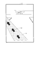
- FIG. 4 is a diagram illustrating an example of a captured image displayed on a display unit in the embodiment.
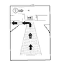
- FIG. 7 is a diagram illustrating a display example of an augmented reality image indicating a traveling route in the embodiment.
- FIG. 14 is a diagram illustrating another display example of an augmented reality image indicating a traveling route in the embodiment.
- FIG. 14 is a diagram illustrating a display example of an augmented reality image indicating a traveling direction of the other party in the embodiment. It is a figure showing the example of a display of the augmented reality image which shows the direction of the other party in the above-mentioned embodiment.
- FIG. 14 is a diagram illustrating an example of an augmented reality image indicating which direction the partner is facing in relation to the user in the embodiment.
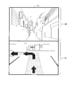
- FIG. 9 is a diagram illustrating a display example when a captured image from another device is displayed on a display unit in the embodiment.
- FIG. 13 is a diagram illustrating an example of a warning screen indicating that the user is moving away from the position of the other party in the embodiment.
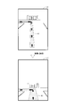
- FIG. 14 is a diagram illustrating a display example of a time required until the self and the other party meet in the embodiment.
- FIG. 7 is a diagram illustrating an example in which the width of a route image is changed according to the distance between the self and the other party in the embodiment.
- FIG. 7 is a diagram illustrating an example in which an augmented reality image is superimposed on an actual captured video and displayed in the embodiment.
- FIG. 7 is a diagram illustrating an example in which an augmented reality image is superimposed on an actual captured video and displayed in the embodiment.
- FIG. 7 is a diagram illustrating an example in which an augmented reality image is superimposed on an actual captured video and displayed in the embodiment.
- FIG. 1 is a block diagram showing a device configuration for realizing a route guidance system according to an embodiment of the present invention.
- This route guidance system is realized by the server 20 and the two mobile terminal devices 10.
- the server 20 and the mobile terminal device 10 are connected via a communication line such as the Internet.
- a route guidance application is installed in the mobile terminal device 10 to realize the route guidance system.
- the route guidance application according to the present embodiment is software for presenting a route from the current position of the user to the current position of the waiting partner when meeting with a person after meeting.
- the user can activate the route guidance application by a predetermined operation.
- a function of setting a fixed position as a destination and presenting a route from the current position of the user to the destination may be provided in the route guidance application, but such a function is provided by the present invention. Is not directly related, and a description thereof will be omitted.
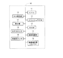
- FIG. 2 is a block diagram illustrating a hardware configuration of the mobile terminal device 10.
- the mobile terminal device 10 includes a CPU 11, a flash ROM 12, a RAM 13, a communication control unit 14, a video photographing unit (camera) 15, an input operation unit 16, a display unit 17, a GPS sensor 18, and a geomagnetic sensor 19.
- the CPU 11 performs various arithmetic processes and the like in order to control the entire portable terminal device 10.
- the flash ROM 12 is a writable non-volatile memory, and stores various programs and various data to be retained even when the power of the portable terminal device 10 is turned off.
- the RAM 13 is a writable volatile memory, and temporarily stores a running program, data, and the like.
- the communication control unit 14 controls external data transmission and external data reception.
- the video capturing unit (camera) 15 captures a landscape viewable from the current position based on a user operation.
- the input operation unit 16 is, for example, a touch panel, and receives an input operation by a user.
- the display unit 17 displays an image based on a command from the CPU 11.
- the GPS sensor 18 acquires position information (latitude / longitude information) for specifying the current position of the user based on radio waves received from GPS satellites.
- the geomagnetic sensor 19 acquires azimuth information indicating the azimuth of the mobile terminal device 10 (for example, the azimuth of the display unit 17).
- the GPS sensor 18 and the terrestrial magnetism sensor 19 are provided as sensors in the mobile terminal device 10 is described, but other sensors (for example, acceleration sensors) are provided in the mobile terminal device 10. Sometimes it is.
- a route guidance program for implementing a route guidance application is stored in the flash ROM 12.
- the route guidance program stored in the flash ROM 12 is read into the RAM 13, and the CPU 11 executes the route guidance program read into the RAM 13.
- the mobile terminal device 10 functions as a route guidance device that provides various functions for route guidance to the user.
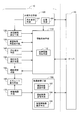
- FIG. 3 is a block diagram showing a detailed functional configuration of the portable terminal device 10 functioning as a route guidance device.
- the portable terminal device 10 functionally includes a sharing establishing unit 100, an information sharing unit 110, an approval time setting unit 120, an approval time resetting unit 130, an azimuth detecting unit 140, and a current position detecting unit. It has means 150, route search means 160, video photographing means 170, AR route display means 180, and video reference means 190.
- the sharing establishment means 100 includes a sharing request means 102 and a response means 104.
- the information sharing means 110 includes a position information sharing means 112.
- the image reference unit 190 includes a photographed image request unit 192, a photographed image transmitting unit 194, and another device image display unit 196.
- the mobile terminal device 10 of interest here is referred to as “own device”, and the other mobile terminal device 10 is referred to as “other device”. That.
- the exchange of data and the like between the own device and another device is performed via the server 20. However, exchange of data or the like between the own apparatus and another apparatus may be directly performed.
- the sharing establishing means 100 establishes a state in which information on the current position of each device is shared between the own device and another device.
- the sharing request unit 102 requests other devices to share information on the current position.
- the response unit 104 notifies the other device whether or not the request is permitted when the request for sharing the current position information is received from the other device.
- the response unit 104 of the own device responds to the request by the sharing request unit 102 of the other device.
- a state is established in which information on the current position of each device is shared between the own device and the other device.
- a screen prompting the user to enter a passcode is displayed, and a passcode that is predetermined by two users is entered. Only when this occurs, the information on the current position may be shared.
- the information sharing unit 110 maintains a state in which various information including the current position information is shared via the server 20 between the own apparatus and another apparatus.
- the information sharing unit 110 transmits the information of the own device to the server 20 and acquires the information of the other device from the server 20 so that the other device can refer to the information of the own device.
- the location information sharing means 112 shares information on the current location between the own apparatus and another apparatus.
- Approval time setting means 120 is an approval time for permitting the sharing of information on the current position when a response to the request by sharing request means 102 of the own apparatus is received from response means 104 of the other apparatus. (Length of time).
- the approval time resetting means 130 resets the approval time when the approval time set by the approval time setting means 120 has elapsed.
- the azimuth detecting means 140 detects the azimuth of the mobile terminal device 10.
- the azimuth detecting means 140 is realized by the geomagnetic sensor 19 (see FIG. 2) as hardware.
- the current position detecting unit 150 detects the current position of the user based on radio waves received from GPS satellites.
- the current position detecting means 150 is realized by the GPS sensor 18 (see FIG. 2) as hardware.
- the position detection using GPS is described as an example, but the present invention is not limited to this.
- the current position may be detected using an indoor positioning technology such as Wi-Fi or a beacon, or a VIO (Visual-Inertial Odometry) technology (a technology for recognizing a position using an image of a camera and an inertial sensor). May be used to detect the current position.
- VIO Visual-Inertial Odometry
- the route searching unit 160 determines the current position of the own device based on the information on the current position of the own device detected by the current position detecting unit 150 and the information on the current position of the other device shared by the position information sharing unit 112. A search is made for a traveling route from to the current position of another device.
- the video capturing means 170 captures a landscape video.
- the image photographing means 170 is realized by the image photographing unit (camera) 15 (see FIG. 2) as hardware.
- a photographed image (landscape image) as a result of photographing by the image photographing means 170 is displayed on the display unit 17.
- the AR route display unit 180 displays an augmented reality (AR) image indicating the traveling route obtained by the route searching unit 160 on the captured video. Thereby, the captured video in which the augmented reality image is embedded is displayed on the display unit 17.
- AR augmented reality
- the image reference unit 190 realizes display of an image captured by another device on the own device and display of an image captured by the own device on another device.
- the photographed image request unit 192 requests the other device to transmit a photographed image (a photographed image that is a result of photographing by the image photographing unit 170 of the other device).
- the photographed image transmitting unit 194 transmits a photographed image (a photographed image that is a result of photographing by the image photographing unit 170 of the own device) to another device when there is a request for transmission of the photographed image from another device.
- the other device video display means 196 displays the captured video on the display unit 17 when another device transmits the captured video in response to the request from the captured video request means 192.
- the position information acquisition unit is realized by the current position detection unit 150
- the route display output unit is realized by the AR route display unit 180
- the other device image display output unit is realized by the other device image display unit 196. Has been realized.
- FIG. 4 is a flowchart illustrating a processing procedure in a case where the own device is the mobile terminal device 10 on the request transmission side.
- the user of the own device After the standby state (step S100) after the start of the route guidance application, the user of the own device transmits a command requesting the other device to share the current position information (step S110). That is, the sharing request unit 102 of the own device requests the other device to share the information of the current position.
- step S120 After that, based on the notification transmitted from the other device, it is determined whether or not the above request is permitted (step S120). As a result, if the above request is not permitted, the process returns to step S100. On the other hand, if the above request is permitted, the approval time setting means 120 performs a process of setting a time (approval time) during which the information on the current position is allowed to be shared (step S130). In this step S130, for example, a screen for inputting the approval time is displayed on the display unit 17 of the own device, and the user inputs an appropriate length of time from the screen. Thus, the processing of the following steps S140 to S160 is repeated until the approval time set in step S130 elapses. In step S120, if no notification is transmitted from another device within a certain period of time after transmitting the command for requesting the sharing of the current position information, it may be determined that the request has not been permitted.
- step S140 information on the current positions of the own device and the other device, which is the position information necessary for the route search, is obtained.
- the current position information of the own device is acquired by the current position detecting means 150 (GPS sensor 18) based on the radio wave received from the GPS satellite, and the information of the current position of the other device held in the server 20 is obtained. It is acquired by the position information sharing unit 112.
- the route searching means 160 searches for a traveling route from the current position of the own device to the current position of another device (step S150).
- the display unit 17 of the own device displays an augmented reality image indicating the traveling route so as to be superimposed on the captured video (the video captured by the video capturing unit 170) (step S160).
- a route along the road (a route that can actually travel) from the current position of the own device to the current position of the other device is displayed as a travel route using augmented reality technology.
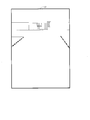
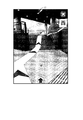
- a captured image as shown in FIG. 6 is displayed on the display unit 17 before displaying the augmented reality image, for example.
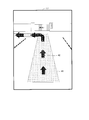
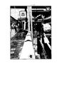
- the display unit 17 displays the augmented reality image in the captured video as shown in FIG.
- a path image 41 whose line width is reduced as the distance from the current position is reduced, and an arrow image 42 indicating the traveling direction are displayed as augmented reality images on the captured video.
- a straight path from the current position of the own device to the current position of another device may be displayed as a traveling route using augmented reality technology.
- the display mode of the augmented reality image indicating the traveling route may be changed according to the linear distance between the current position of the own device and the current position of another device. For example, if the straight-line distance is equal to or greater than a predetermined threshold, a route along the road from the current position of the own device to the current position of the other device is displayed as a traveling route in the augmented reality image as shown in FIG. If the distance is less than the predetermined threshold, a linear path from the current position of the own device to the current position of the other device may be displayed as an advancing reality image in the augmented reality image as shown in FIG.
- Step S170 it is determined whether or not the approval time set in step S130 has elapsed (determination as to whether or not the approval time has elapsed from a predetermined timing such as the completion of the setting of the approval time). As a result, if the approval time has not elapsed, the process returns to step S140, and if the approval time has elapsed, the process proceeds to step S180.
- step S180 it is determined whether or not the approval time has been reset. As a result, if the approval time has been reset, the process returns to step S130. If the approval time has not been reset, the process proceeds to step S190.
- step S180 first, a screen for confirming with the user whether or not to extend the approval time is displayed on the display unit 17 of the own device. On that screen, the user selects whether to extend the approval time. If the user selects to extend the approval time, a screen for inputting the approval time is displayed on the display unit 17 of the own device again, and the user inputs an appropriate length of time from the screen. . If the approval time is reset, the information of the approval time after the reset is transmitted to the server 20. If the approval time is not reset, the information to that effect is transmitted to the server 20. You.
- step S190 sharing of position information and the like between the own device and another device ends. As a result, the route guidance from the current position of the own device to the current position of the other device ends.
- steps S140 to S160 are repeated, so that the photographed video and the augmented reality image in the display unit 17 change at any time in accordance with the change in the current position / direction of the user and the change in the current position of the partner. I do.
- the user only has to proceed according to the augmented reality image indicating the traveling route.
- the approval time can be reset, but the present invention is not limited to this.
- the shared state of the information on the current position is forcibly canceled. You may make it.
- FIG. 5 is a flowchart illustrating a processing procedure when the own device is the mobile terminal device 10 on the request receiving side.
- a command requesting sharing of the current position information from another device is received (step S210). That is, the sharing establishing means 100 receives a command (a command for requesting sharing of information on the current position) transmitted from another device.
- the user determines whether to permit a request from another device. That is, the response unit 104 notifies the other device whether to permit the request from the other device.
- it is determined whether a request from another device has been permitted (step S220). As a result, if the request has not been granted, the process returns to step S200. On the other hand, if the request has been permitted, the process proceeds to step S230.
- step S230 the information sharing unit 110 acquires information on the approval time from the server 20.
- the processing of the following steps S240 to S260 is repeated until the approval time has elapsed.
- step S240 information on the current positions of the own device and the other devices, which is the position information necessary for the route search, is obtained. These pieces of information are obtained in the same manner as in step S140. Then, based on the position information acquired in step S240, the route search means 160 searches for a traveling route from the current position of the own device to the current position of another device (step S250).
- the display unit 17 of the own device displays an augmented reality image indicating the traveling route so as to overlap the captured video (step S260).
- the display of the augmented reality image in step S260 is performed in the same manner as in step S160.
- step S270 After the augmented reality image is displayed, it is determined whether the approval time has elapsed (step S270). As a result, if the approval time has not elapsed, the process returns to step S240, and if the approval time has elapsed, the process proceeds to step S280.
- step S280 it is determined whether or not resetting of the approval time has been performed by another device. As a result, if the approval time has been reset, the process returns to step S230. If the approval time has not been reset, the process proceeds to step S290.
- the approval time is reset, information on the approval time after the reset is acquired from the server 20 by the information sharing unit 110.
- step S290 sharing of position information and the like between the own device and another device ends. As a result, the route guidance from the current position of the own device to the current position of the other device ends.
- steps S240 to S260 are repeated, similarly to steps S140 to S160 of the request transmitting side.
- the captured video and the augmented reality image in the display unit 17 change at any time according to the change in the current position / direction of the user and the change in the current position of the partner.
- the user only has to proceed according to the augmented reality image indicating the traveling route.
- the augmented reality image displayed on the display unit 17 of both portable terminal devices 10 is updated as at least one of the two moves. If the two do not meet within the approval time, the approval time is reset if necessary. As described above, both of them eventually proceed according to the augmented reality image indicating the traveling path, and thus finally meet each other.
- the augmented reality image (see FIGS. 7 and 8) showing the traveling path has been illustrated as an example of the augmented reality image displayed over the captured video.
- an augmented reality image indicating additional information may be displayed in addition to the augmented reality image indicating the traveling route. This will be described below.
- the information on the traveling direction of the other party is useful information. For example, if it is known that the other party is moving away from the self, it is possible to tell the other party to confirm the traveling direction by calling the other party.
- an augmented reality image indicating the traveling direction of the other party may be displayed at a predetermined position on the display unit 17 as indicated by the dotted line 43 in FIG.
- the user can grasp the traveling direction of the opponent from the augmented reality image composed of the mark of the person and the arrow.
- a function of specifying the user's orientation based on the orientation information detected by the orientation detection means 140 is provided in the portable terminal device 10, as shown by a dotted line portion denoted by reference numeral 44 in FIG.
- an augmented reality image indicating the direction of the other party may be displayed at a predetermined position on the display unit 17.
- a plurality of images are prepared as shown in FIG. 11 indicating which direction the partner is facing in relation to the self, and an image corresponding to the actual direction of the partner is displayed. What is necessary is just to display in the predetermined position of the part 17.
- an augmented reality image composed of a face mark indicating the direction and an arrow may be displayed at a predetermined position on the display unit 17 as indicated by a dotted line indicated by reference numeral 45 in FIG.
- the user can grasp the direction of the opponent and the traveling direction of the opponent.
- the route guidance application is provided with a function of displaying a video taken by another device on the display unit 17 of the own device. This function is realized by the video reference unit 190 (see FIG. 3).
- the photographed image requesting unit 192 requests the other device to transmit a photographed image.
- the photographed image transmitting unit 194 of the other device transmits a photographed image (here, a still image) as a result of photographing by the image photographing unit 170 of the other device. It should be noted that the request for transmitting the captured video may be rejected.
- the photographed image is displayed on the display unit 17 by the other device image display unit 196.
- an image as shown in FIG. 13 is displayed on the display unit 17 of the own device.
- a captured video (including an augmented reality image) from the own device is displayed in a portion denoted by reference numeral 51, and a captured video from another device is displayed in a portion denoted by reference numeral 52.
- reference numeral 51 a captured video from another device is displayed in a portion denoted by reference numeral 52.
- a screen (typically, a pop-up screen) for warning that the user is moving away from the position of the other party is displayed on the display unit 17 like a screen indicated by reference numeral 46 in FIG. Is also good.
- the time required for the self and the other party to meet each other may be displayed at a predetermined position on the display unit 17.
- the user can grasp the time required for meeting with the other party, so that the user's stress at the time of meeting can be reduced.
- the width of the route image 41 is displayed thicker so that the degree of approach between the self and the other party can be visually grasped. You may do it.
- FIGS. 17 to 19 show examples in which an augmented reality image is superimposed on an actual photographed video and displayed.
- an augmented reality image indicating the direction and an augmented reality image indicating the current position of the other party are displayed.
- an augmented reality image indicating a direction and an augmented reality image indicating a distance from a current position of the user to a next turn are displayed in addition to the augmented reality image indicating a traveling path.
- various augmented reality images indicating additional information may be displayed.
- the route search means 160 searches for a traveling route from the current position of the own device to the current position of the other device, and an augmented reality image indicating the traveling route is displayed on the display unit 17 so as to overlap the captured video. Since the direction of the current position of the waiting partner is indicated by using the augmented reality image in this way, when the self and the waiting partner approach each other, the waiting partner can be easily found regardless of the surrounding environment. As described above, according to the present embodiment, at the time of a meeting (meeting by two people), regardless of the environment (congestion degree, space size, complexity of the structure of a building, etc.) of the place where both meet, Can easily meet each other.
- the traveling route is shown using the augmented reality image
- the user can intuitively grasp the direction in which the user should go, and the user can meet the other party simply by following the augmented reality image showing the traveling route Can be. In this way, the meeting becomes remarkably easy as compared with the related art using the 2D map.
- information on the current position of each other is shared only when the other device accepts the request (request for sharing information on the current position) from one device. That is, information on the current position is shared between mutually authenticated persons. This prevents privacy infringement due to unauthorized sharing of information on the current location.
- the length of time during which the information on the current location is shared (approval time) can be set, privacy infringement due to the unintended continuous sharing of the information on the current location can be prevented.
- the approval time can be reset, the route guidance for the queuing can be continued without re-performing the mutual authentication process between the two when the approval time has elapsed.
Landscapes
- Engineering & Computer Science (AREA)
- Radar, Positioning & Navigation (AREA)
- Remote Sensing (AREA)
- Automation & Control Theory (AREA)
- Physics & Mathematics (AREA)
- General Physics & Mathematics (AREA)
- Navigation (AREA)
- Traffic Control Systems (AREA)
- Noodles (AREA)
Abstract
待ち合わせ(2人での待ち合わせ)の際に両者が落ち合う場所の環境に関わらず両者が容易に落ち合うことを可能にする。 経路案内プログラムは、撮影映像を表示部に表示する機能を有する携帯端末装置(10)に含まれるコンピュータを、自装置の現在位置の情報を随時取得する現在位置検出手段(150)、自装置と他装置との間で互いの現在位置の情報を共有する位置情報共有手段(112)、現在位置検出手段(150)によって取得された自装置の現在位置の情報と位置情報共有手段(112)によって共有された他装置の現在位置の情報とに基づいて自装置の現在位置から他装置の現在位置までの進行経路の探索を行う経路探索手段(160)、および、経路探索手段(160)によって得られた進行経路を示す拡張現実画像を撮影映像に重ねて表示するARルート表示手段(180)として機能させる。
Description
本発明は、端末装置(典型的には携帯電話などの携帯端末装置)のユーザーに拡張現実(AR)技術を用いて経路案内を行う経路案内プログラムを記録した記録媒体、経路案内装置、および経路案内システムに関する。
携帯電話などの携帯端末装置の高機能化・高解像度化により、近年、地図を利用するアプリケーションソフトウェア(以下、「アプリ」と略記する。)が多く開発されている。そのようなアプリの1つとして、携帯端末装置の利用者(以下、「ユーザー」という。)を目的地に案内するための「経路案内アプリ」などと呼ばれるアプリが知られている。経路案内アプリでは、ユーザーの現在位置から目的地までの経路探索が行われ、その結果が携帯端末装置の画面上に地図とともに表示される。このような経路案内アプリを利用することにより、ユーザーは手元に地図がない場合でも目的地に容易にたどり着くことができる。
ところで、人の行為として「待ち合わせ」は日常的になされる行為である。一般に、待ち合わせは場所を特定して行われる。従って、上述した経路案内アプリは、待ち合わせの際にもユーザーに利用される。ところが、待ち合わせ時間になっても待ち合わせ場所に相手が現れない場合、人はストレスを感じることが多い。また、そのような場合、人は相手の現在位置を知りたくなることが多い。そこで、近年、携帯端末装置の複数のユーザーが互いの位置情報を共有できるようにするサービスが提供されている。このサービスによれば、待ち合わせの際に、ユーザーは他人の現在位置を地図上で確認することができる。
また、日本の特開2000-348286号公報および日本の特開2010-192994号公報には、1対1で互いに自己の現在位置から相手の現在位置までの経路の探索・表示(2次元の地図上での表示)を行うシステムの発明が開示されている。
上述した従来技術によれば、相手の現在位置の情報は2次元の地図(以下、「2D地図」という。)上に表示される。従って、待ち合わせの際に自己の現在位置と相手の現在位置との平面的な関係を把握することができる。ところが、待ち合わせ場所の環境によっては、2D地図上では自己と相手とが近い距離にいるにも関わらず両者が落ち合うまでに相当の時間を要することが多々ある。これに関し、例えば以下に記すような要因によって、待ち合わせの際に両者が互いに相手を発見することが阻害されることがある。
1:待ち合わせ場所が混雑している(例えば、主要駅の改札口前、イベント会場前)。
2:待ち合わせ場所が空間的に広くかつ好適な目印が存在しない(例えば、巨大なライブ会場、巨大なテーマパーク)。
3:待ち合わせ場所としての建物の構造が複雑である(例えば、主要駅の地下街、デパートやショッピングモールなどの巨大な商業施設)。
1:待ち合わせ場所が混雑している(例えば、主要駅の改札口前、イベント会場前)。
2:待ち合わせ場所が空間的に広くかつ好適な目印が存在しない(例えば、巨大なライブ会場、巨大なテーマパーク)。
3:待ち合わせ場所としての建物の構造が複雑である(例えば、主要駅の地下街、デパートやショッピングモールなどの巨大な商業施設)。
以上の点に鑑み、本発明は、待ち合わせ(2人での待ち合わせ)の際に両者が落ち合う場所の環境(混雑度、空間の広さ、建物等の構造の複雑さ)に関わらず両者が容易に落ち合うことを可能にすることを目的とする。
本発明の第1の局面は、撮影映像を表示部に表示する機能を有する携帯端末装置に含まれるコンピュータを、
自装置の現在位置の情報を随時取得する位置情報取得部、
前記自装置と他装置との間で互いの現在位置の情報を共有する位置情報共有部、
前記位置情報取得部によって取得された前記自装置の現在位置の情報と前記位置情報共有部によって共有された前記他装置の現在位置の情報とに基づいて前記自装置の現在位置から前記他装置の現在位置までの進行経路の探索を行う経路探索部、および、
前記経路探索部によって得られた進行経路を示す拡張現実画像を前記撮影映像に重ねて表示する経路表示出力部
として機能させるための経路案内プログラムを記録したコンピュータ読み取り可能な記録媒体である。
自装置の現在位置の情報を随時取得する位置情報取得部、
前記自装置と他装置との間で互いの現在位置の情報を共有する位置情報共有部、
前記位置情報取得部によって取得された前記自装置の現在位置の情報と前記位置情報共有部によって共有された前記他装置の現在位置の情報とに基づいて前記自装置の現在位置から前記他装置の現在位置までの進行経路の探索を行う経路探索部、および、
前記経路探索部によって得られた進行経路を示す拡張現実画像を前記撮影映像に重ねて表示する経路表示出力部
として機能させるための経路案内プログラムを記録したコンピュータ読み取り可能な記録媒体である。
本発明の第2の局面は、本発明の第1の局面において、
前記経路案内プログラムは、
前記コンピュータを、
前記他装置に対して現在位置の情報の共有を要求する共有要求部、および、
前記他装置から現在位置の情報の共有の要求があったときに当該要求を許容するか否かを前記他装置に通知する応答部
として更に機能させ、
前記共有要求部による要求に対して前記他装置から当該要求を許容する旨の通知があった場合および前記応答部が前記他装置からの要求を許容した場合に、前記位置情報共有部による現在位置の情報の共有が行われる。
前記経路案内プログラムは、
前記コンピュータを、
前記他装置に対して現在位置の情報の共有を要求する共有要求部、および、
前記他装置から現在位置の情報の共有の要求があったときに当該要求を許容するか否かを前記他装置に通知する応答部
として更に機能させ、
前記共有要求部による要求に対して前記他装置から当該要求を許容する旨の通知があった場合および前記応答部が前記他装置からの要求を許容した場合に、前記位置情報共有部による現在位置の情報の共有が行われる。
本発明の第3の局面は、本発明の第2の局面において、
前記経路案内プログラムは、
前記コンピュータを、
前記共有要求部による要求に対して前記他装置から当該要求を許容する旨の通知があった場合に現在位置の情報の共有を許容する承認時間を設定する承認時間設定部として更に機能させ、
所定のタイミングから前記承認時間設定部によって設定された承認時間が経過するまでの期間、前記位置情報共有部による現在位置の情報の共有が行われる。
前記経路案内プログラムは、
前記コンピュータを、
前記共有要求部による要求に対して前記他装置から当該要求を許容する旨の通知があった場合に現在位置の情報の共有を許容する承認時間を設定する承認時間設定部として更に機能させ、
所定のタイミングから前記承認時間設定部によって設定された承認時間が経過するまでの期間、前記位置情報共有部による現在位置の情報の共有が行われる。
本発明の第4の局面は、本発明の第3の局面において、
前記経路案内プログラムは、
前記コンピュータを、
前記所定のタイミングから前記承認時間設定部によって設定された承認時間が経過したときに承認時間の再設定を行う承認時間再設定部として更に機能させる。
前記経路案内プログラムは、
前記コンピュータを、
前記所定のタイミングから前記承認時間設定部によって設定された承認時間が経過したときに承認時間の再設定を行う承認時間再設定部として更に機能させる。
本発明の第5の局面は、本発明の第1の局面において、
前記経路表示出力部は、前記進行経路を示す拡張現実画像に加えて、前記他装置の進行方向を示す拡張現実画像を表示する。
前記経路表示出力部は、前記進行経路を示す拡張現実画像に加えて、前記他装置の進行方向を示す拡張現実画像を表示する。
本発明の第6の局面は、本発明の第1の局面において、
前記経路表示出力部は、前記進行経路を示す拡張現実画像に加えて、前記他装置の所持者の向きを示す拡張現実画像を表示する。
前記経路表示出力部は、前記進行経路を示す拡張現実画像に加えて、前記他装置の所持者の向きを示す拡張現実画像を表示する。
本発明の第7の局面は、本発明の第1の局面において、
前記経路案内プログラムは、
前記コンピュータを、
前記他装置に対して撮影映像の送信を要求する撮影映像要求部、
前記他装置から撮影映像の送信の要求があったときに前記自装置の撮影映像を前記他装置に送信する撮影映像送信部、および、
前記撮影映像要求部による要求に対して前記他装置から撮影映像の送信があった場合に当該撮影映像を前記表示部に表示する他装置映像表示出力部
として更に機能させる。
前記経路案内プログラムは、
前記コンピュータを、
前記他装置に対して撮影映像の送信を要求する撮影映像要求部、
前記他装置から撮影映像の送信の要求があったときに前記自装置の撮影映像を前記他装置に送信する撮影映像送信部、および、
前記撮影映像要求部による要求に対して前記他装置から撮影映像の送信があった場合に当該撮影映像を前記表示部に表示する他装置映像表示出力部
として更に機能させる。
本発明の第8の局面は、本発明の第1の局面において、
前記自装置の現在位置と前記他装置の現在位置との間の直線距離が所定の閾値以上であれば、前記経路探索部によって、前記進行経路として、前記自装置の現在位置から前記他装置の現在位置までの道路に沿った経路が得られ、
前記自装置の現在位置と前記他装置の現在位置との間の直線距離が前記所定の閾値未満であれば、前記経路探索部によって、前記進行経路として、前記自装置の現在位置から前記他装置の現在位置までの直線の経路が得られる。
前記自装置の現在位置と前記他装置の現在位置との間の直線距離が所定の閾値以上であれば、前記経路探索部によって、前記進行経路として、前記自装置の現在位置から前記他装置の現在位置までの道路に沿った経路が得られ、
前記自装置の現在位置と前記他装置の現在位置との間の直線距離が前記所定の閾値未満であれば、前記経路探索部によって、前記進行経路として、前記自装置の現在位置から前記他装置の現在位置までの直線の経路が得られる。
本発明の第9の局面は、表示部を有する経路案内装置であって、
前記表示部に撮影映像を表示する撮影映像表示出力部と、
自装置の現在位置の情報を随時取得する位置情報取得部と、
前記自装置と他装置との間で互いの現在位置の情報を共有する位置情報共有部と、
前記位置情報取得部によって取得された前記自装置の現在位置の情報と前記位置情報共有部によって共有された前記他装置の現在位置の情報とに基づいて前記自装置の現在位置から前記他装置の現在位置までの進行経路の探索を行う経路探索部と、
前記経路探索部によって得られた進行経路を示す拡張現実画像を前記撮影映像に重ねて表示する経路表示出力部と
を備える。
前記表示部に撮影映像を表示する撮影映像表示出力部と、
自装置の現在位置の情報を随時取得する位置情報取得部と、
前記自装置と他装置との間で互いの現在位置の情報を共有する位置情報共有部と、
前記位置情報取得部によって取得された前記自装置の現在位置の情報と前記位置情報共有部によって共有された前記他装置の現在位置の情報とに基づいて前記自装置の現在位置から前記他装置の現在位置までの進行経路の探索を行う経路探索部と、
前記経路探索部によって得られた進行経路を示す拡張現実画像を前記撮影映像に重ねて表示する経路表示出力部と
を備える。
本発明の第10の局面は、表示部を有する2つの携帯端末装置である第1の携帯端末装置と第2の携帯端末装置とによって実現される経路案内システムであって、
各携帯端末装置は、
前記表示部に撮影映像を表示する撮影映像表示出力部と、
自装置の現在位置の情報を随時取得する位置情報取得部と、
前記自装置と他装置との間で互いの現在位置の情報を共有する位置情報共有部と、
前記位置情報取得部によって取得された前記自装置の現在位置の情報と前記位置情報共有部によって共有された前記他装置の現在位置の情報とに基づいて前記自装置の現在位置から前記他装置の現在位置までの進行経路の探索を行う経路探索部と、
前記経路探索部によって得られた進行経路を示す拡張現実画像を前記撮影映像に重ねて表示する経路表示出力部と
を備える。
各携帯端末装置は、
前記表示部に撮影映像を表示する撮影映像表示出力部と、
自装置の現在位置の情報を随時取得する位置情報取得部と、
前記自装置と他装置との間で互いの現在位置の情報を共有する位置情報共有部と、
前記位置情報取得部によって取得された前記自装置の現在位置の情報と前記位置情報共有部によって共有された前記他装置の現在位置の情報とに基づいて前記自装置の現在位置から前記他装置の現在位置までの進行経路の探索を行う経路探索部と、
前記経路探索部によって得られた進行経路を示す拡張現実画像を前記撮影映像に重ねて表示する経路表示出力部と
を備える。
本発明の第1の局面によれば、自装置と他装置との間で互いの現在位置の情報が共有される。そして、経路探索手段によって自装置の現在位置から他装置の現在位置までの進行経路の探索が行われ、進行経路を示す拡張現実画像が撮影映像に重ねて表示される。このように待ち合わせ相手の現在位置の方向が拡張現実画像を用いて示されることから、自己と待ち合わせ相手とが接近したときに周囲の環境に関わらず待ち合わせ相手を容易に発見することができる。以上のように、待ち合わせ(2人での待ち合わせ)の際に、両者が落ち合う場所の環境(混雑度、空間の広さ、建物等の構造の複雑さ)に関わらず、両者が容易に落ち合うことが可能となる。また、自装置の現在位置から他装置の現在位置までの進行経路が示されることから、待ち合わせの際に特定の待ち合わせ場所を定めることが不要となる。さらに、進行経路は拡張現実画像を用いて示されるので、ユーザーは自己の進むべき方向を直感的に把握することができ、ユーザーは進行経路を示す拡張現実画像に従って進行するだけで相手と落ち合うことができる。
本発明の第2の局面によれば、互いに認証された者同士で現在位置の情報の共有が行われることになるので、現在位置の情報が不正に共有されることによるプライバシーの侵害が防止される。
本発明の第3の局面によれば、現在位置の情報の共有状態が意図せず長時間継続することによるプライバシーの侵害が防止される。
本発明の第4の局面によれば、承認時間の再設定が可能であるので、承認時間が経過したときに2人のユーザー間で互いに認証を行う処理を再度やり直すことなく待ち合わせのための経路案内を継続することができる。
本発明の第5の局面によれば、待ち合わせ相手が自己に近づくように移動しているかどうかを確認することが可能となる。
本発明の第6の局面によれば、例えば初対面の人と待ち合わせをする際に、両者が落ち合う場所が混雑していても相手の特定が容易となる。
本発明の第7の局面によれば、待ち合わせ相手が見ている風景を確認することができるので、待ち合わせ相手の現在位置を詳細に把握することが可能となる。
本発明の第8の局面によれば、自己と相手とが離れている時には相手に近づくように移動することが容易となり、自己と相手とが近い位置にいる時には相手を探すのが容易となる。
本発明の第9の局面によれば、本発明の第1の局面と同様の効果が得られる。
本発明の第10の局面によれば、本発明の第1の局面と同様の効果が得られる。
以下、添付図面を参照しつつ本発明の一実施形態について説明する。
<1.全体構成>
図1は、本発明の一実施形態に係る経路案内システムを実現する機器構成を示すブロック図である。この経路案内システムは、サーバ20と2台の携帯端末装置10とによって実現される。サーバ20と携帯端末装置10とは、インターネットなどの通信回線を介して接続される。本実施形態においては、この経路案内システムを実現するために、経路案内アプリが携帯端末装置10にインストールされる。本実施形態における経路案内アプリは、待ち合わせをして人と落ち合う際に自己の現在位置から待ち合わせ相手の現在位置までの経路を提示するためのソフトウェアである。ユーザーは、所定の操作により経路案内アプリを起動することができる。なお、目的地として固定された位置を設定して自己の現在位置から当該目的地までの経路を提示する機能がこの経路案内アプリに設けられていても良いが、そのような機能は本発明には直接には関係しないので、それについての説明は省略する。
図1は、本発明の一実施形態に係る経路案内システムを実現する機器構成を示すブロック図である。この経路案内システムは、サーバ20と2台の携帯端末装置10とによって実現される。サーバ20と携帯端末装置10とは、インターネットなどの通信回線を介して接続される。本実施形態においては、この経路案内システムを実現するために、経路案内アプリが携帯端末装置10にインストールされる。本実施形態における経路案内アプリは、待ち合わせをして人と落ち合う際に自己の現在位置から待ち合わせ相手の現在位置までの経路を提示するためのソフトウェアである。ユーザーは、所定の操作により経路案内アプリを起動することができる。なお、目的地として固定された位置を設定して自己の現在位置から当該目的地までの経路を提示する機能がこの経路案内アプリに設けられていても良いが、そのような機能は本発明には直接には関係しないので、それについての説明は省略する。
<2.携帯端末装置のハードウェア構成>
図2は、携帯端末装置10のハードウェア構成を示すブロック図である。携帯端末装置10は、CPU11,フラッシュROM12,RAM13,通信制御部14,映像撮影部(カメラ)15,入力操作部16,表示部17,GPSセンサ18,および地磁気センサ19を有している。CPU11は、この携帯端末装置10の全体を制御するために各種演算処理等を行う。フラッシュROM12は、書き込み可能な不揮発性のメモリであって、携帯端末装置10の電源がオフされても保持されるべき各種プログラム・各種データを格納する。RAM13は、書き込み可能な揮発性のメモリであって、実行中のプログラムやデータ等を一時的に格納する。通信制御部14は、外部へのデータ送信の制御や外部からのデータ受信の制御を行う。映像撮影部(カメラ)15は、ユーザーによる操作に基づいて、現在位置から見える風景の撮影を行う。入力操作部16は、例えばタッチパネルであって、ユーザーによる入力操作を受け付ける。表示部17は、CPU11からの指令に基づいて、画像の表示を行う。GPSセンサ18は、GPS衛星から受信する電波に基づいて、ユーザーの現在位置を特定するための位置情報(緯度・経度の情報)を取得する。地磁気センサ19は、この携帯端末装置10の向いている方位(例えば表示部17の向いている方位)を示す方位情報を取得する。なお、ここではセンサとしてGPSセンサ18および地磁気センサ19が携帯端末装置10に設けられている例を挙げて説明しているが、それら以外のセンサ(例えば、加速度センサ)が携帯端末装置10に設けられていることもある。
図2は、携帯端末装置10のハードウェア構成を示すブロック図である。携帯端末装置10は、CPU11,フラッシュROM12,RAM13,通信制御部14,映像撮影部(カメラ)15,入力操作部16,表示部17,GPSセンサ18,および地磁気センサ19を有している。CPU11は、この携帯端末装置10の全体を制御するために各種演算処理等を行う。フラッシュROM12は、書き込み可能な不揮発性のメモリであって、携帯端末装置10の電源がオフされても保持されるべき各種プログラム・各種データを格納する。RAM13は、書き込み可能な揮発性のメモリであって、実行中のプログラムやデータ等を一時的に格納する。通信制御部14は、外部へのデータ送信の制御や外部からのデータ受信の制御を行う。映像撮影部(カメラ)15は、ユーザーによる操作に基づいて、現在位置から見える風景の撮影を行う。入力操作部16は、例えばタッチパネルであって、ユーザーによる入力操作を受け付ける。表示部17は、CPU11からの指令に基づいて、画像の表示を行う。GPSセンサ18は、GPS衛星から受信する電波に基づいて、ユーザーの現在位置を特定するための位置情報(緯度・経度の情報)を取得する。地磁気センサ19は、この携帯端末装置10の向いている方位(例えば表示部17の向いている方位)を示す方位情報を取得する。なお、ここではセンサとしてGPSセンサ18および地磁気センサ19が携帯端末装置10に設けられている例を挙げて説明しているが、それら以外のセンサ(例えば、加速度センサ)が携帯端末装置10に設けられていることもある。
携帯端末装置10内において、経路案内アプリを実現する経路案内プログラムは、フラッシュROM12に格納される。ユーザーによって経路案内アプリの起動が指示されると、フラッシュROM12に格納されている経路案内プログラムがRAM13に読み出され、そのRAM13に読み出された経路案内プログラムをCPU11が実行する。これによる、携帯端末装置10は、経路案内のための各種機能をユーザーに提供する経路案内装置として機能する。
<3.機能構成>
図3は、経路案内装置として機能する携帯端末装置10の詳細な機能構成を示すブロック図である。図3に示すように、この携帯端末装置10は、機能的には、共有確立手段100,情報共有手段110,承認時間設定手段120,承認時間再設定手段130,方位検出手段140,現在位置検出手段150,経路探索手段160,映像撮影手段170,ARルート表示手段180,および映像参照手段190を有している。共有確立手段100には、共有要求手段102と応答手段104とが含まれている。情報共有手段110には、位置情報共有手段112が含まれている。映像参照手段190には、撮影映像要求手段192と撮影映像送信手段194と他装置映像表示手段196とが含まれている。
図3は、経路案内装置として機能する携帯端末装置10の詳細な機能構成を示すブロック図である。図3に示すように、この携帯端末装置10は、機能的には、共有確立手段100,情報共有手段110,承認時間設定手段120,承認時間再設定手段130,方位検出手段140,現在位置検出手段150,経路探索手段160,映像撮影手段170,ARルート表示手段180,および映像参照手段190を有している。共有確立手段100には、共有要求手段102と応答手段104とが含まれている。情報共有手段110には、位置情報共有手段112が含まれている。映像参照手段190には、撮影映像要求手段192と撮影映像送信手段194と他装置映像表示手段196とが含まれている。
なお、以下においては、経路案内システムを実現する2台の携帯端末装置10のうちここで着目している携帯端末装置10を「自装置」といい、他方の携帯端末装置10を「他装置」という。自装置と他装置との間のデータ等のやりとりはサーバ20を介して行われる。但し、自装置と他装置との間でデータ等のやりとりが直接的に行われても良い。
共有確立手段100は、自装置と他装置との間で互いの現在位置の情報が共有された状態を確立する。共有要求手段102は、他装置に対して現在位置の情報の共有を要求する。応答手段104は、他装置から現在位置の情報の共有の要求があったときに当該要求を許容するか否かを他装置に通知する。自装置の共有要求手段102による要求に対して他装置の応答手段104から当該要求を許容する旨の通知があった場合および他装置の共有要求手段102による要求に対して自装置の応答手段104が当該要求を許容する旨の通知を行った場合に、自装置と他装置との間で互いの現在位置の情報が共有された状態が確立される。なお、共有要求手段102による要求が行われる際および応答手段104による応答が行われる際にパスコードの入力を促す画面を表示し、2人のユーザーによって予め定められているパスコードの入力が行われた場合に限って現在位置の情報の共有が可能となるようにしても良い。
情報共有手段110は、自装置と他装置との間で現在位置の情報を含む各種情報がサーバ20を介して共有された状態を維持する。換言すれば、情報共有手段110は、他装置が自装置の情報を参照することができるよう自装置の情報をサーバ20に送信するとともにサーバ20から他装置の情報を取得する。位置情報共有手段112は、自装置と他装置との間で互いの現在位置の情報を共有する。
承認時間設定手段120は、自装置の共有要求手段102による要求に対して他装置の応答手段104から当該要求を許容する旨の通知があった場合に現在位置の情報の共有を許容する承認時間(時間の長さ)を設定する。承認時間再設定手段130は、承認時間設定手段120によって設定された承認時間が経過したときに承認時間の再設定を行う。
方位検出手段140は、この携帯端末装置10の向いている方位を検出する。この方位検出手段140は、ハードウェアとしての地磁気センサ19(図2参照)によって実現される。現在位置検出手段150は、GPS衛星から受信する電波に基づいて、ユーザーの現在位置を検出する。この現在位置検出手段150は、ハードウェアとしてのGPSセンサ18(図2参照)によって実現される。なお、ここではGPSを用いた位置検出を例に挙げて説明しているが、本発明はこれに限定されない。例えば、Wi-Fiやビーコンなどの屋内測位技術を用いて現在位置を検出しても良いし、VIO(Visual-Inertial Odometry)技術(カメラの映像および慣性センサを使って位置の認識を行う技術)を用いて現在位置を検出しても良い。
経路探索手段160は、現在位置検出手段150によって検出された自装置の現在位置の情報と位置情報共有手段112によって共有されている他装置の現在位置の情報とに基づいて、自装置の現在位置から他装置の現在位置までの進行経路の探索を行う。なお、経路探索手段160による進行経路の探索の際には適宜のタイミングでサーバ20からダウンロードされる道路情報等が用いられるが、これについては本発明には直接には関係しないので、それに関する説明は省略する。映像撮影手段170は、風景映像の撮影を行う。この映像撮影手段170は、ハードウェアとしての映像撮影部(カメラ)15(図2参照)によって実現される。映像撮影手段170による撮影の結果である撮影映像(風景映像)は表示部17に表示される。ARルート表示手段180は、経路探索手段160によって得られた進行経路を示す拡張現実(AR)画像を撮影映像に重ねて表示する。これにより、表示部17には、拡張現実画像が埋め込まれた撮影映像が表示される。
映像参照手段190は、他装置で撮影された映像の自装置での表示および自装置で撮影された映像の他装置での表示を実現する。撮影映像要求手段192は、他装置に対して撮影映像(他装置の映像撮影手段170による撮影の結果である撮影映像)の送信を要求する。撮影映像送信手段194は、他装置から撮影映像の送信の要求があったときに撮影映像(自装置の映像撮影手段170による撮影の結果である撮影映像)を他装置に送信する。他装置映像表示手段196は、撮影映像要求手段192による要求に対して他装置から撮影映像の送信があった場合に当該撮影映像を表示部17に表示する。
なお、本実施形態においては、現在位置検出手段150によって位置情報取得部が実現され、ARルート表示手段180によって経路表示出力部が実現され、他装置映像表示手段196によって他装置映像表示出力部が実現されている。
<4.処理手順>
次に、本実施形態における経路案内(自己の現在位置から相手の現在位置までの進行経路の案内)の処理手順について説明する。ここでは、まず現在位置の情報の共有を要求する側(以下、「リクエスト送信側」という。)の処理手順(図4参照)について説明し、次いで現在位置の情報の共有が要求される側(以下、「リクエスト受信側」という。)の処理手順(図5参照)について説明する。
次に、本実施形態における経路案内(自己の現在位置から相手の現在位置までの進行経路の案内)の処理手順について説明する。ここでは、まず現在位置の情報の共有を要求する側(以下、「リクエスト送信側」という。)の処理手順(図4参照)について説明し、次いで現在位置の情報の共有が要求される側(以下、「リクエスト受信側」という。)の処理手順(図5参照)について説明する。
<4.1 リクエスト送信側の処理手順>
図4は、自装置がリクエスト送信側の携帯端末装置10となる場合の処理手順を示すフローチャートである。経路案内アプリの起動後に待機状態(ステップS100)があった後、自装置のユーザーによって、他装置に対して現在位置の情報の共有を要求する指令が送信される(ステップS110)。すなわち、自装置の共有要求手段102によって、他装置に対して現在位置の情報の共有が要求される。
図4は、自装置がリクエスト送信側の携帯端末装置10となる場合の処理手順を示すフローチャートである。経路案内アプリの起動後に待機状態(ステップS100)があった後、自装置のユーザーによって、他装置に対して現在位置の情報の共有を要求する指令が送信される(ステップS110)。すなわち、自装置の共有要求手段102によって、他装置に対して現在位置の情報の共有が要求される。
その後、他装置から送信される通知に基づいて、上述の要求が許可されたか否かの判定が行われる(ステップS120)。その結果、上述の要求が許可されなかった場合には、処理はステップS100に戻る。一方、上述の要求が許可された場合には、承認時間設定手段120によって、現在位置の情報の共有を許容する時間(承認時間)を設定する処理が行われる(ステップS130)。このステップS130では、例えば、自装置の表示部17に承認時間を入力するための画面が表示され、当該画面からユーザーが適宜の長さの時間を入力する。これにより、このステップS130で設定された承認時間が経過するまで、以下のステップS140~S160の処理が繰り返される。なお、ステップS120では、現在位置の情報の共有を要求する指令を送信してから一定時間内に他装置から何ら通知が送信されなければ、要求が許可されなかったと判断すれば良い。
ステップS140では、経路探索に必要な位置情報である自装置および他装置の現在位置の情報の取得が行われる。詳しくは、GPS衛星から受信する電波に基づき現在位置検出手段150(GPSセンサ18)によって自装置の現在位置の情報が取得されるとともに、サーバ20に保持されている他装置の現在位置の情報が位置情報共有手段112によって取得される。その後、ステップS140で取得された位置情報に基づいて、経路探索手段160によって、自装置の現在位置から他装置の現在位置までの進行経路の探索が行われる(ステップS150)。
進行経路の探索後、自装置の表示部17において、撮影映像(映像撮影手段170によって撮影されている映像)に重ねて進行経路を示す拡張現実画像が表示される(ステップS160)。本実施形態においては、自装置の現在位置から他装置の現在位置までの道路に沿った経路(実際に進行することのできる経路)が進行経路として拡張現実技術を用いて表示される。これに関し、例えば拡張現実画像の表示前に表示部17に図6に示すような撮影映像が表示されていると仮定する。この場合、ステップS160では、表示部17には、図7に示すように撮影映像内に拡張現実画像が表示される。図7に示す例では、拡張現実画像として、現在位置から遠ざかるにつれて線幅を狭くした経路画像41と、進行方向を表す矢印画像42とが撮影映像に重ねて表示されている。
なお、例えば図8に示すように、自装置の現在位置から他装置の現在位置までの直線の経路が進行経路として拡張現実技術を用いて表示されても良い。また、自装置の現在位置と他装置の現在位置との間の直線距離に応じて進行経路を示す拡張現実画像の表示態様を変化させるようにしても良い。例えば、上記直線距離が所定の閾値以上であれば図7に示すように自装置の現在位置から他装置の現在位置までの道路に沿った経路を進行経路として拡張現実画像で表示し、上記直線距離が所定の閾値未満であれば図8に示すように自装置の現在位置から他装置の現在位置までの直線の経路を進行経路として拡張現実画像で表示するようにしても良い。
拡張現実画像の表示後、ステップS130で設定された承認時間が経過したか否かの判定(承認時間の設定完了時点などの所定のタイミングから承認時間が経過したか否かの判定)が行われる(ステップS170)。その結果、承認時間が経過していなければ処理はステップS140に戻り、承認時間が経過していれば処理はステップS180に進む。
ステップS180では、承認時間が再設定されたか否かの判定が行われる。その結果、承認時間が再設定された場合には処理はステップS130に戻り、承認時間が再設定されなかった場合には処理はステップS190に進む。このステップS180では、まず、承認時間を延長するか否かをユーザーに確認する画面が自装置の表示部17に表示される。その画面において、ユーザーは承認時間を延長するか否かを選択する。承認時間を延長する旨の選択が行われた場合には、再度承認時間を入力するための画面が自装置の表示部17に表示され、当該画面からユーザーが適宜の長さの時間を入力する。なお、承認時間が再設定された場合には、再設定後の承認時間の情報がサーバ20に送信され、承認時間が再設定されなかった場合には、その旨の情報がサーバ20に送信される。
ステップS190では、自装置と他装置との間での位置情報等の共有が終了する。その結果、自装置の現在位置から他装置の現在位置までの経路案内が終了する。
ところで、上述したようにステップS140~S160の処理が繰り返されることにより、自己の現在位置・向きの変化および相手の現在位置の変化に応じて表示部17内の撮影映像・拡張現実画像は随時変化する。ユーザーは、進行経路を示す拡張現実画像に従って進行すれば良い。
なお、本実施形態では承認時間の再設定が可能であるが、本発明はこれに限定されず、最初に設定された承認時間が経過した時に現在位置の情報の共有状態が強制的に解消されるようにしても良い。
<4.2 リクエスト受信側の処理手順>
図5は、自装置がリクエスト受信側の携帯端末装置10となる場合の処理手順を示すフローチャートである。経路案内アプリの起動後に待機状態(ステップS200)があった後、他装置からの現在位置の情報の共有を要求する指令が受信される(ステップS210)。すなわち、他装置から送信された指令(現在位置の情報の共有を要求する指令)を共有確立手段100が受信する。ユーザーは、他装置からの要求を許可するか否かを決定する。すなわち、応答手段104が、他装置からの要求を許可するか否かを当該他装置に対して通知する。そして、他装置からの要求が許可されたか否かの判定が行われる(ステップS220)。その結果、要求が許可されなかった場合には、処理はステップS200に戻る。一方、要求が許可された場合には、処理はステップS230に進む。
図5は、自装置がリクエスト受信側の携帯端末装置10となる場合の処理手順を示すフローチャートである。経路案内アプリの起動後に待機状態(ステップS200)があった後、他装置からの現在位置の情報の共有を要求する指令が受信される(ステップS210)。すなわち、他装置から送信された指令(現在位置の情報の共有を要求する指令)を共有確立手段100が受信する。ユーザーは、他装置からの要求を許可するか否かを決定する。すなわち、応答手段104が、他装置からの要求を許可するか否かを当該他装置に対して通知する。そして、他装置からの要求が許可されたか否かの判定が行われる(ステップS220)。その結果、要求が許可されなかった場合には、処理はステップS200に戻る。一方、要求が許可された場合には、処理はステップS230に進む。
ユーザーが他装置からの要求を許可した場合には、他装置で上述した承認時間の設定が行われる。その承認時間の情報は、他装置からサーバ20に送信される。そして、ステップS230において、情報共有手段110によってサーバ20から承認時間の情報が取得される。これにより、その承認時間が経過するまで、以下のステップS240~S260の処理が繰り返される。
ステップS240では、経路探索に必要な位置情報である自装置および他装置の現在位置の情報の取得が行われる。なお、これらの情報は上記ステップS140と同様にして取得される。そして、ステップS240で取得された位置情報に基づいて、経路探索手段160によって、自装置の現在位置から他装置の現在位置までの進行経路の探索が行われる(ステップS250)。
進行経路の探索後、自装置の表示部17において、撮影映像に重ねて進行経路を示す拡張現実画像が表示される(ステップS260)。このステップS260での拡張現実画像の表示は上記ステップS160と同様にして行われる。
拡張現実画像の表示後、承認時間が経過したか否かの判定が行われる(ステップS270)。その結果、承認時間が経過していなければ処理はステップS240に戻り、承認時間が経過していれば処理はステップS280に進む。
承認時間が経過したとき、承認時間の再設定を行うか否かの判断が他装置のユーザーによって行われる。自装置では、ステップS280において、承認時間の再設定が他装置で行われたか否かの判定が行われる。その結果、承認時間が再設定された場合には処理はステップS230に戻り、承認時間が再設定されなかった場合には処理はステップS290に進む。なお、承認時間が再設定された場合には、再設定後の承認時間の情報が情報共有手段110によってサーバ20から取得される。
ステップS290では、自装置と他装置との間での位置情報等の共有が終了する。その結果、自装置の現在位置から他装置の現在位置までの経路案内が終了する。
リクエスト受信側においても、リクエスト送信側のステップS140~S160と同様、ステップS240~S260の処理が繰り返される。これにより、自己の現在位置・向きの変化および相手の現在位置の変化に応じて表示部17内の撮影映像・拡張現実画像は随時変化する。ユーザーは、進行経路を示す拡張現実画像に従って進行すれば良い。
<4.3 まとめ>
以上のように、まず、リクエスト送信側のユーザーとリクエスト受信側のユーザーとの間で互いに認証を行う処理が行われる。その後、両者の現在位置の情報が共有され、リクエスト送信側の携帯端末装置10の表示部17にはリクエスト送信側のユーザーの現在位置からリクエスト受信側のユーザーの現在位置までの進行経路が拡張現実画像を用いて表示され、リクエスト受信側の携帯端末装置10の表示部17にはリクエスト受信側のユーザーの現在位置からリクエスト送信側のユーザーの現在位置までの進行経路が拡張現実画像を用いて表示される。両者は、進行経路を示す拡張現実画像に従って進行する。その際、両者の少なくとも一方が移動するのに応じて、両者の携帯端末装置10の表示部17に表示されている拡張現実画像が更新される。また、承認時間内に両者が落ち合わなければ、必要に応じて承認時間が再設定される。以上のようにして両者が進行経路を示す拡張現実画像に従って進行することにより、最終的に両者は落ち合う。
以上のように、まず、リクエスト送信側のユーザーとリクエスト受信側のユーザーとの間で互いに認証を行う処理が行われる。その後、両者の現在位置の情報が共有され、リクエスト送信側の携帯端末装置10の表示部17にはリクエスト送信側のユーザーの現在位置からリクエスト受信側のユーザーの現在位置までの進行経路が拡張現実画像を用いて表示され、リクエスト受信側の携帯端末装置10の表示部17にはリクエスト受信側のユーザーの現在位置からリクエスト送信側のユーザーの現在位置までの進行経路が拡張現実画像を用いて表示される。両者は、進行経路を示す拡張現実画像に従って進行する。その際、両者の少なくとも一方が移動するのに応じて、両者の携帯端末装置10の表示部17に表示されている拡張現実画像が更新される。また、承認時間内に両者が落ち合わなければ、必要に応じて承認時間が再設定される。以上のようにして両者が進行経路を示す拡張現実画像に従って進行することにより、最終的に両者は落ち合う。
<5.表示画面>
上記においては、撮影映像に重ねて表示される拡張現実画像の例として、進行経路を示す拡張現実画像(図7および図8を参照)を例示した。しかしながら、進行経路を示す拡張現実画像の他に付加的な情報を示す拡張現実画像を表示するようにしても良い。これについて以下に説明する。
上記においては、撮影映像に重ねて表示される拡張現実画像の例として、進行経路を示す拡張現実画像(図7および図8を参照)を例示した。しかしながら、進行経路を示す拡張現実画像の他に付加的な情報を示す拡張現実画像を表示するようにしても良い。これについて以下に説明する。
この経路案内アプリを用いて待ち合わせをする際、相手の進行方向の情報は有用な情報となる。例えば、相手が自己から遠ざかるように移動していることがわかれば、相手に電話をかけるなどによって進行方向を確認するよう伝えることができる。そこで、図9で符号43を付した点線部分に示すように、相手の進行方向(他装置の進行方向)を示す拡張現実画像を表示部17の所定の位置に表示するようにしても良い。図9に示す例では、ユーザーは人のマークと矢印とで構成される拡張現実画像によって相手の進行方向を把握することが可能となっている。
また、特に初対面の人と待ち合わせをする際には、混雑していても相手の特定が容易となるよう相手の向きを把握できることが好ましい。そこで、方位検出手段140(地磁気センサ19)によって検出される方位の情報に基づいてユーザーの向きを特定する機能を携帯端末装置10に設け、図10で符号44を付した点線部分に示すように、相手(他装置の所持者)の向きを示す拡張現実画像を表示部17の所定の位置に表示するようにしても良い。これに関し、例えば、自己との関係で相手がどちらを向いているかを表す図11に示すような複数の画像(拡張現実画像)を用意しておき、実際の相手の向きに応じた画像を表示部17の所定の位置に表示すれば良い。
なお、図12で符号45を付した点線部分に示すように、向きを示す顔のマークと矢印とで構成される拡張現実画像を表示部17の所定の位置に表示するようにしても良い。これにより、ユーザーは相手の向きと相手の進行方向とを把握することが可能となる。
待ち合わせをする際、相手の現在位置を把握するために相手が見ている風景を知りたいことが多々ある。そこで、この経路案内アプリには、他装置で撮影された映像を自装置の表示部17に表示する機能が設けられている。この機能は映像参照手段190(図3参照)によって実現される。本実施形態においては、この機能を実行するメニューがユーザーによって選択されると、撮影映像要求手段192によって他装置に対して撮影映像の送信の要求が行われる。これに対して、他装置の撮影映像送信手段194は、当該他装置の映像撮影手段170による撮影の結果である撮影映像(ここでは静止画)の送信を行う。なお、撮影映像の送信の要求に対して当該要求を拒否することができるようにしても良い。自装置では、撮影映像要求手段192による要求に対して他装置から撮影映像の送信があると、他装置映像表示手段196によって当該撮影映像が表示部17に表示される。これにより、自装置の表示部17には、例えば図13に示すような映像が表示される。図13に示す例では、符号51を付した部分に自装置からの撮影映像(拡張現実画像を含む)が表示され、符号52を付した部分に他装置からの撮影映像が表示されている。このように、相手が見ている風景を確認することができるので、相手の現在位置を詳細に把握することが可能となる。
この経路案内アプリを用いて待ち合わせをしている際、誤った方向に進行したときに進行方向の誤りについてできるだけ早く気づくことが好ましい。そこで、そのような場合に図14で符号46を付した画面のように相手の位置から遠ざかっている旨の警告を行う画面(典型的にはポップアップ画面)を表示部17に表示するようにしても良い。
待ち合わせをしている際、人は、相手と落ち合えるまでの時間が不明な時にストレスを感じることが多々ある。そこで、図15で符号47を付した点線部分に示すように、自己と相手とが落ち合えるまでの所要時間を表示部17の所定の位置に表示するようにしても良い。これにより、ユーザーは相手と落ち合えるまでの所要時間を把握することができるので、待ち合わせの際のユーザーのストレスが軽減される。なお、自己と相手との接近の程度を視覚的に把握することができるよう、例えば図16に示すように、自己と相手との距離が短くなるにつれて経路画像41の幅が太く表示されるようにしても良い。
図17~図19には、実際の撮影映像に拡張現実画像を重ねて表示した例を示している。図17および図18に示す例では、進行経路を示す拡張現実画像の他、方角を示す拡張現実画像や相手の現在位置を示す拡張現実画像(「G」と表示されている画像)が表示されている。図19に示す例では、進行経路を示す拡張現実画像の他、方角を示す拡張現実画像や自己の現在位置から次に曲がる位置までの距離を示す拡張現実画像が表示されている。以上のように、進行経路を示す拡張現実画像の他に付加的な情報を示す様々な拡張現実画像を表示するようにしても良い。
<6.効果>
本実施形態によれば、自装置と他装置との間で互いの現在位置の情報が共有される。そして、経路探索手段160によって自装置の現在位置から他装置の現在位置までの進行経路の探索が行われ、表示部17には進行経路を示す拡張現実画像が撮影映像に重ねて表示される。このように待ち合わせ相手の現在位置の方向が拡張現実画像を用いて示されることから、自己と待ち合わせ相手とが接近したときに周囲の環境に関わらず待ち合わせ相手を容易に発見することができる。以上より、本実施形態によれば、待ち合わせ(2人での待ち合わせ)の際に、両者が落ち合う場所の環境(混雑度、空間の広さ、建物等の構造の複雑さ)に関わらず、両者が容易に落ち合うことが可能となる。
本実施形態によれば、自装置と他装置との間で互いの現在位置の情報が共有される。そして、経路探索手段160によって自装置の現在位置から他装置の現在位置までの進行経路の探索が行われ、表示部17には進行経路を示す拡張現実画像が撮影映像に重ねて表示される。このように待ち合わせ相手の現在位置の方向が拡張現実画像を用いて示されることから、自己と待ち合わせ相手とが接近したときに周囲の環境に関わらず待ち合わせ相手を容易に発見することができる。以上より、本実施形態によれば、待ち合わせ(2人での待ち合わせ)の際に、両者が落ち合う場所の環境(混雑度、空間の広さ、建物等の構造の複雑さ)に関わらず、両者が容易に落ち合うことが可能となる。
また、両者の携帯端末装置10の表示部17には互いに相手の現在位置までの進行経路が表示されるので、待ち合わせの際に特定の待ち合わせ場所を定めることが不要となる。
さらに、進行経路は拡張現実画像を用いて示されるので、ユーザーは自己の進むべき方向を直感的に把握することができ、ユーザーは進行経路を示す拡張現実画像に従って進行するだけで相手と落ち合うことができる。このように、2D地図を用いた従来技術と比較して待ち合わせが顕著に容易となる。
さらにまた、一方の装置からの要求(現在位置の情報の共有の要求)に対して他方の装置が当該要求を許容した場合にのみ互いの現在位置の情報が共有される。すなわち、互いに認証された者同士で、現在位置の情報の共有が行われる。これにより、現在位置の情報が不正に共有されることによるプライバシーの侵害が防止される。また、現在位置の情報が共有される時間の長さ(承認時間)を設定することができるので、現在位置の情報の共有状態が意図せず長時間継続することによるプライバシーの侵害が防止される。また、承認時間の再設定が可能であるので、承認時間が経過したときに両者間で互いに認証を行う処理を再度やり直すことなく待ち合わせのための経路案内を継続することができる。
<7.その他>
本発明は、上記実施形態に限定されるものではなく、本発明の趣旨を逸脱しない範囲で種々変形して実施することができる。
本発明は、上記実施形態に限定されるものではなく、本発明の趣旨を逸脱しない範囲で種々変形して実施することができる。
10…携帯端末装置
20…サーバ
100…共有確立手段
102…共有要求手段
104…応答手段
110…情報共有手段
112…位置情報共有手段
120…承認時間設定手段
130…承認時間再設定手段
140…方位検出手段
150…現在位置検出手段
160…経路探索手段
170…映像撮影手段
180…ARルート表示手段
190…映像参照手段
192…撮影映像要求手段
194…撮影映像送信手段
196…他装置映像表示手段
20…サーバ
100…共有確立手段
102…共有要求手段
104…応答手段
110…情報共有手段
112…位置情報共有手段
120…承認時間設定手段
130…承認時間再設定手段
140…方位検出手段
150…現在位置検出手段
160…経路探索手段
170…映像撮影手段
180…ARルート表示手段
190…映像参照手段
192…撮影映像要求手段
194…撮影映像送信手段
196…他装置映像表示手段
Claims (10)
- 撮影映像を表示部に表示する機能を有する携帯端末装置に含まれるコンピュータを、
自装置の現在位置の情報を随時取得する位置情報取得部、
前記自装置と他装置との間で互いの現在位置の情報を共有する位置情報共有部、
前記位置情報取得部によって取得された前記自装置の現在位置の情報と前記位置情報共有部によって共有された前記他装置の現在位置の情報とに基づいて前記自装置の現在位置から前記他装置の現在位置までの進行経路の探索を行う経路探索部、および、
前記経路探索部によって得られた進行経路を示す拡張現実画像を前記撮影映像に重ねて表示する経路表示出力部
として機能させるための経路案内プログラムを記録した非一過性のコンピュータ読み取り可能な記録媒体。 - 前記経路案内プログラムは、
前記コンピュータを、
前記他装置に対して現在位置の情報の共有を要求する共有要求部、および、
前記他装置から現在位置の情報の共有の要求があったときに当該要求を許容するか否かを前記他装置に通知する応答部
として更に機能させ、
前記共有要求部による要求に対して前記他装置から当該要求を許容する旨の通知があった場合および前記応答部が前記他装置からの要求を許容した場合に、前記位置情報共有部による現在位置の情報の共有が行われる、請求項1に記載のコンピュータ読み取り可能な記録媒体。 - 前記経路案内プログラムは、
前記コンピュータを、
前記共有要求部による要求に対して前記他装置から当該要求を許容する旨の通知があった場合に現在位置の情報の共有を許容する承認時間を設定する承認時間設定部として更に機能させ、
所定のタイミングから前記承認時間設定部によって設定された承認時間が経過するまでの期間、前記位置情報共有部による現在位置の情報の共有が行われる、請求項2に記載のコンピュータ読み取り可能な記録媒体。 - 前記経路案内プログラムは、
前記コンピュータを、
前記所定のタイミングから前記承認時間設定部によって設定された承認時間が経過したときに承認時間の再設定を行う承認時間再設定部として更に機能させる、請求項3に記載のコンピュータ読み取り可能な記録媒体。 - 前記経路表示出力部は、前記進行経路を示す拡張現実画像に加えて、前記他装置の進行方向を示す拡張現実画像を表示する、請求項1に記載のコンピュータ読み取り可能な記録媒体。
- 前記経路表示出力部は、前記進行経路を示す拡張現実画像に加えて、前記他装置の所持者の向きを示す拡張現実画像を表示する、請求項1に記載のコンピュータ読み取り可能な記録媒体。
- 前記経路案内プログラムは、
前記コンピュータを、
前記他装置に対して撮影映像の送信を要求する撮影映像要求部、
前記他装置から撮影映像の送信の要求があったときに前記自装置の撮影映像を前記他装置に送信する撮影映像送信部、および、
前記撮影映像要求部による要求に対して前記他装置から撮影映像の送信があった場合に当該撮影映像を前記表示部に表示する他装置映像表示出力部
として更に機能させる、請求項1に記載のコンピュータ読み取り可能な記録媒体。 - 前記自装置の現在位置と前記他装置の現在位置との間の直線距離が所定の閾値以上であれば、前記経路探索部によって、前記進行経路として、前記自装置の現在位置から前記他装置の現在位置までの道路に沿った経路が得られ、
前記自装置の現在位置と前記他装置の現在位置との間の直線距離が前記所定の閾値未満であれば、前記経路探索部によって、前記進行経路として、前記自装置の現在位置から前記他装置の現在位置までの直線の経路が得られる、請求項1に記載のコンピュータ読み取り可能な記録媒体。 - 表示部を有する経路案内装置であって、
前記表示部に撮影映像を表示する撮影映像表示出力部と、
自装置の現在位置の情報を随時取得する位置情報取得部と、
前記自装置と他装置との間で互いの現在位置の情報を共有する位置情報共有部と、
前記位置情報取得部によって取得された前記自装置の現在位置の情報と前記位置情報共有部によって共有された前記他装置の現在位置の情報とに基づいて前記自装置の現在位置から前記他装置の現在位置までの進行経路の探索を行う経路探索部と、
前記経路探索部によって得られた進行経路を示す拡張現実画像を前記撮影映像に重ねて表示する経路表示出力部と
を備える、経路案内装置。 - 表示部を有する2つの携帯端末装置である第1の携帯端末装置と第2の携帯端末装置とによって実現される経路案内システムであって、
各携帯端末装置は、
前記表示部に撮影映像を表示する撮影映像表示出力部と、
自装置の現在位置の情報を随時取得する位置情報取得部と、
前記自装置と他装置との間で互いの現在位置の情報を共有する位置情報共有部と、
前記位置情報取得部によって取得された前記自装置の現在位置の情報と前記位置情報共有部によって共有された前記他装置の現在位置の情報とに基づいて前記自装置の現在位置から前記他装置の現在位置までの進行経路の探索を行う経路探索部と、
前記経路探索部によって得られた進行経路を示す拡張現実画像を前記撮影映像に重ねて表示する経路表示出力部と
を備える、経路案内システム。
Priority Applications (2)
| Application Number | Priority Date | Filing Date | Title |
|---|---|---|---|
| CN201980048247.1A CN112449674A (zh) | 2018-09-18 | 2019-07-16 | 记录有路径引导程序的存储介质、路径引导装置以及路径引导系统 |
| KR1020217001842A KR20210024041A (ko) | 2018-09-18 | 2019-07-16 | 경로 안내 프로그램을 기록한 기록 매체, 경로 안내 장치, 및 경로 안내 시스템 |
Applications Claiming Priority (2)
| Application Number | Priority Date | Filing Date | Title |
|---|---|---|---|
| JP2018173793A JP7146542B2 (ja) | 2018-09-18 | 2018-09-18 | 経路案内プログラム、経路案内装置、および経路案内システム |
| JP2018-173793 | 2018-09-18 |
Publications (1)
| Publication Number | Publication Date |
|---|---|
| WO2020059271A1 true WO2020059271A1 (ja) | 2020-03-26 |
Family
ID=69888660
Family Applications (1)
| Application Number | Title | Priority Date | Filing Date |
|---|---|---|---|
| PCT/JP2019/027868 Ceased WO2020059271A1 (ja) | 2018-09-18 | 2019-07-16 | 経路案内プログラムを記録した記録媒体、経路案内装置、および経路案内システム |
Country Status (5)
| Country | Link |
|---|---|
| JP (1) | JP7146542B2 (ja) |
| KR (1) | KR20210024041A (ja) |
| CN (1) | CN112449674A (ja) |
| TW (1) | TWI768225B (ja) |
| WO (1) | WO2020059271A1 (ja) |
Cited By (1)
| Publication number | Priority date | Publication date | Assignee | Title |
|---|---|---|---|---|
| WO2022039011A1 (ja) * | 2020-08-18 | 2022-02-24 | 株式会社ビーブリッジ | コンピュータシステムによるナビゲーション |
Families Citing this family (6)
| Publication number | Priority date | Publication date | Assignee | Title |
|---|---|---|---|---|
| CN111627114A (zh) * | 2020-04-14 | 2020-09-04 | 北京迈格威科技有限公司 | 室内视觉导航方法、装置、系统及电子设备 |
| KR102458102B1 (ko) | 2020-09-18 | 2022-10-24 | 네이버랩스 주식회사 | 증강현실 뷰를 사용하는 경로 안내 방법 및 장치 |
| JP7568580B2 (ja) * | 2021-05-26 | 2024-10-16 | 東日本旅客鉄道株式会社 | 経路表示装置、経路表示方法及び経路表示プログラム |
| CN114754764A (zh) * | 2022-06-15 | 2022-07-15 | 上海维智卓新信息科技有限公司 | 基于增强现实的导航方法及装置 |
| CN115523940B (zh) * | 2022-09-26 | 2023-12-05 | 北京百度网讯科技有限公司 | 导航显示方法、装置、电子设备及存储介质 |
| JP7801589B2 (ja) * | 2023-01-18 | 2026-01-19 | 株式会社カプコン | コンピュータプログラム、コンピュータ装置、およびコンピュータシステム |
Citations (8)
| Publication number | Priority date | Publication date | Assignee | Title |
|---|---|---|---|---|
| JP2003222532A (ja) * | 1995-03-06 | 2003-08-08 | Aisin Aw Co Ltd | ナビゲーション装置 |
| JP2004056408A (ja) * | 2002-07-19 | 2004-02-19 | Hitachi Ltd | 携帯電話端末 |
| JP2004274653A (ja) * | 2003-03-12 | 2004-09-30 | Hitachi Ltd | 移動端末及びコンピュータ・ソフトウエア |
| JP2006194665A (ja) * | 2005-01-12 | 2006-07-27 | Sanyo Electric Co Ltd | ナビゲーション機能付き携帯型端末機 |
| WO2008044309A1 (fr) * | 2006-10-13 | 2008-04-17 | Navitime Japan Co., Ltd. | Système de navigation, dispositif de borne mobile et procédé de guidage de route |
| JP2012244630A (ja) * | 2011-05-23 | 2012-12-10 | Apple Inc | モバイルネットワークにおけるユーザの特定及び位置探索 |
| JP2015072523A (ja) * | 2013-10-01 | 2015-04-16 | アイシン・エィ・ダブリュ株式会社 | 情報提供システム、情報提供方法、移動情報端末及びコンピュータプログラム |
| JP2015219119A (ja) * | 2014-05-19 | 2015-12-07 | パイオニア株式会社 | 探索装置、探索装置の制御方法およびプログラム |
Family Cites Families (20)
| Publication number | Priority date | Publication date | Assignee | Title |
|---|---|---|---|---|
| JPH09126797A (ja) * | 1995-10-27 | 1997-05-16 | Fujitsu Ten Ltd | 経路探索装置 |
| JP2000348286A (ja) | 1999-06-04 | 2000-12-15 | Sharp Corp | 相互通信手段を持つナビゲーションシステム |
| JP2005221407A (ja) * | 2004-02-06 | 2005-08-18 | Matsushita Electric Ind Co Ltd | ナビゲーション装置 |
| EP1729088B1 (en) * | 2004-03-26 | 2011-04-27 | Pioneer Corporation | Navigation device, route searching method, route searching program, and computer-readable recording medium |
| JP2005326775A (ja) * | 2004-05-17 | 2005-11-24 | Mitsubishi Electric Corp | ナビゲーションシステム |
| US20090005018A1 (en) * | 2007-06-28 | 2009-01-01 | Apple Inc. | Route Sharing and Location |
| TWI382156B (zh) * | 2008-09-17 | 2013-01-11 | Inventec Appliances Corp | 行動導航裝置及方法 |
| JP5439844B2 (ja) | 2009-02-16 | 2014-03-12 | 日本電気株式会社 | 携帯端末装置、携帯端末システム、それらの位置確認方法及びプログラム |
| TW201213767A (en) * | 2010-09-30 | 2012-04-01 | Mitac Int Corp | Active group navigation system and method thereof |
| CN101945333B (zh) * | 2010-10-19 | 2013-05-08 | 蒋永 | 一种智能手机间的相互定位系统及方法 |
| US9247377B2 (en) * | 2011-05-23 | 2016-01-26 | Apple Inc. | Setting a reminder that is triggered by a target user device |
| CN103968822B (zh) * | 2013-01-24 | 2018-04-13 | 腾讯科技(深圳)有限公司 | 导航方法、用于导航的设备和导航系统 |
| JP2015224981A (ja) * | 2014-05-28 | 2015-12-14 | 株式会社Screenホールディングス | 経路案内装置、経路案内方法、および経路案内プログラム |
| CN104729498A (zh) * | 2015-02-10 | 2015-06-24 | 广东欧珀移动通信有限公司 | 路线的规划方法、装置及移动终端 |
| JP6680499B2 (ja) * | 2015-09-28 | 2020-04-15 | 株式会社Screenホールディングス | 経路案内装置、経路案内システム、経路案内方法、および経路案内プログラム |
| JP6674791B2 (ja) * | 2016-02-17 | 2020-04-01 | 株式会社Screenホールディングス | 混雑度推定方法、人数推定方法、混雑度推定プログラム、人数推定プログラム、および人数推定システム |
| CN108253980B (zh) * | 2016-12-28 | 2020-12-29 | 阿里巴巴(中国)有限公司 | 一种具有封路事件的道路获取方法及装置 |
| JP2018132934A (ja) * | 2017-02-15 | 2018-08-23 | 株式会社Screenホールディングス | 行動分析方法、行動分析プログラム、および行動分析システム |
| CN107202592A (zh) * | 2017-06-06 | 2017-09-26 | 四川长虹电器股份有限公司 | 一种车载实景导航系统与方法 |
| CN108204822B (zh) * | 2017-12-19 | 2021-09-24 | 武汉极目智能技术有限公司 | 一种基于adas的车辆ar导航系统及方法 |
-
2018
- 2018-09-18 JP JP2018173793A patent/JP7146542B2/ja active Active
-
2019
- 2019-07-16 WO PCT/JP2019/027868 patent/WO2020059271A1/ja not_active Ceased
- 2019-07-16 KR KR1020217001842A patent/KR20210024041A/ko not_active Abandoned
- 2019-07-16 CN CN201980048247.1A patent/CN112449674A/zh active Pending
- 2019-07-26 TW TW108126604A patent/TWI768225B/zh not_active IP Right Cessation
Patent Citations (8)
| Publication number | Priority date | Publication date | Assignee | Title |
|---|---|---|---|---|
| JP2003222532A (ja) * | 1995-03-06 | 2003-08-08 | Aisin Aw Co Ltd | ナビゲーション装置 |
| JP2004056408A (ja) * | 2002-07-19 | 2004-02-19 | Hitachi Ltd | 携帯電話端末 |
| JP2004274653A (ja) * | 2003-03-12 | 2004-09-30 | Hitachi Ltd | 移動端末及びコンピュータ・ソフトウエア |
| JP2006194665A (ja) * | 2005-01-12 | 2006-07-27 | Sanyo Electric Co Ltd | ナビゲーション機能付き携帯型端末機 |
| WO2008044309A1 (fr) * | 2006-10-13 | 2008-04-17 | Navitime Japan Co., Ltd. | Système de navigation, dispositif de borne mobile et procédé de guidage de route |
| JP2012244630A (ja) * | 2011-05-23 | 2012-12-10 | Apple Inc | モバイルネットワークにおけるユーザの特定及び位置探索 |
| JP2015072523A (ja) * | 2013-10-01 | 2015-04-16 | アイシン・エィ・ダブリュ株式会社 | 情報提供システム、情報提供方法、移動情報端末及びコンピュータプログラム |
| JP2015219119A (ja) * | 2014-05-19 | 2015-12-07 | パイオニア株式会社 | 探索装置、探索装置の制御方法およびプログラム |
Cited By (3)
| Publication number | Priority date | Publication date | Assignee | Title |
|---|---|---|---|---|
| WO2022039011A1 (ja) * | 2020-08-18 | 2022-02-24 | 株式会社ビーブリッジ | コンピュータシステムによるナビゲーション |
| TWI798789B (zh) * | 2020-08-18 | 2023-04-11 | 日商優橋有限公司 | 導航裝置、導航系統、導航方法及記錄有導航程式的記錄媒體 |
| EP4198949A4 (en) * | 2020-08-18 | 2024-02-14 | Bebridge, Inc. | NAVIGATION USING A COMPUTER SYSTEM |
Also Published As
| Publication number | Publication date |
|---|---|
| TW202013323A (zh) | 2020-04-01 |
| CN112449674A (zh) | 2021-03-05 |
| TWI768225B (zh) | 2022-06-21 |
| JP2020046254A (ja) | 2020-03-26 |
| JP7146542B2 (ja) | 2022-10-04 |
| KR20210024041A (ko) | 2021-03-04 |
Similar Documents
| Publication | Publication Date | Title |
|---|---|---|
| JP7146542B2 (ja) | 経路案内プログラム、経路案内装置、および経路案内システム | |
| US12106409B2 (en) | Server, user terminal, and service providing method, and control method thereof | |
| JP5897791B2 (ja) | ユーザ端末装置、その位置提供方法及びその経路案内方法 | |
| US10077989B2 (en) | Navigation device, navigation method, and non-transitory computer readable storage medium | |
| JP6025433B2 (ja) | 携帯ナビゲーション装置 | |
| KR101838119B1 (ko) | 휴대단말기의 위치 표시 장치 및 방법 | |
| KR101436223B1 (ko) | 궤적 기반 위치 결정을 이용한 이미지 식별 | |
| JP5889538B2 (ja) | 携帯電子機器 | |
| JPWO2018034053A1 (ja) | 情報処理装置、情報処理システム及び情報処理方法 | |
| EP3006898B1 (en) | Mobile terminal and control method thereof | |
| CN107015246A (zh) | 一种基于场景共享的导航协助方法及终端 | |
| KR20190018243A (ko) | 영상 통화를 이용한 길안내 방법 및 시스템 | |
| JP2012145565A (ja) | ポータブル端末で移動経路を提供する装置及び方法 | |
| KR20150088662A (ko) | 증강현실 특이점을 이용한 이동 길 안내 서비스 제공 방법 및 장치 | |
| KR101644608B1 (ko) | 가시 범위 내 통신대상 인식을 위한 단말 및 그 방법 | |
| JP2017067457A (ja) | 経路案内装置、経路案内システム、経路案内方法、および経路案内プログラム | |
| JP2015059769A (ja) | 端末及び制御プログラム | |
| JP2010276364A (ja) | ナビ情報作成装置、ナビゲーションシステム、ナビゲーション情報作成方法、およびナビゲーション方法 | |
| JP6600450B2 (ja) | 場所情報指定装置、場所情報指定方法及び場所情報指定プログラム | |
| KR20110020572A (ko) | 위치정보 제공방법 및 이를 적용한 촬영장치 | |
| JP2019174548A (ja) | 制御装置、電子機器、制御方法、及び制御プログラム | |
| JP2018124925A (ja) | 端末装置及びプログラム | |
| KR20150124055A (ko) | 차량용 단말장치를 이용한 컨텐츠 공유 방법 및 그를 이용하는 장치 | |
| JP6284559B2 (ja) | 携帯電子機器および移動経路記録方法 | |
| KR100684171B1 (ko) | 휴대폰을 이용하는 위치 정보 서비스 시스템 및 방법 |
Legal Events
| Date | Code | Title | Description |
|---|---|---|---|
| 121 | Ep: the epo has been informed by wipo that ep was designated in this application |
Ref document number: 19863412 Country of ref document: EP Kind code of ref document: A1 |
|
| ENP | Entry into the national phase |
Ref document number: 20217001842 Country of ref document: KR Kind code of ref document: A |
|
| NENP | Non-entry into the national phase |
Ref country code: DE |
|
| 122 | Ep: pct application non-entry in european phase |
Ref document number: 19863412 Country of ref document: EP Kind code of ref document: A1 |