EP3287968A1 - Position information common management system for mobile object - Google Patents
Position information common management system for mobile object Download PDFInfo
- Publication number
- EP3287968A1 EP3287968A1 EP17186508.2A EP17186508A EP3287968A1 EP 3287968 A1 EP3287968 A1 EP 3287968A1 EP 17186508 A EP17186508 A EP 17186508A EP 3287968 A1 EP3287968 A1 EP 3287968A1
- Authority
- EP
- European Patent Office
- Prior art keywords
- information
- position information
- processing apparatus
- smartphone
- information processing
- Prior art date
- Legal status (The legal status is an assumption and is not a legal conclusion. Google has not performed a legal analysis and makes no representation as to the accuracy of the status listed.)
- Withdrawn
Links
- 230000010365 information processing Effects 0.000 claims abstract description 213
- 230000005540 biological transmission Effects 0.000 claims abstract description 14
- 238000012545 processing Methods 0.000 description 86
- 238000004891 communication Methods 0.000 description 32
- 238000010586 diagram Methods 0.000 description 11
- 230000008520 organization Effects 0.000 description 8
- 230000008859 change Effects 0.000 description 6
- 230000006870 function Effects 0.000 description 5
- 230000008901 benefit Effects 0.000 description 3
- 230000002123 temporal effect Effects 0.000 description 3
- 239000000470 constituent Substances 0.000 description 2
- 238000001914 filtration Methods 0.000 description 2
- 239000000758 substrate Substances 0.000 description 2
- 238000012546 transfer Methods 0.000 description 2
- 239000003990 capacitor Substances 0.000 description 1
- 238000010276 construction Methods 0.000 description 1
- 238000000034 method Methods 0.000 description 1
- 230000004048 modification Effects 0.000 description 1
- 238000012986 modification Methods 0.000 description 1
Images


Classifications
-
- H—ELECTRICITY
- H04—ELECTRIC COMMUNICATION TECHNIQUE
- H04W—WIRELESS COMMUNICATION NETWORKS
- H04W4/00—Services specially adapted for wireless communication networks; Facilities therefor
- H04W4/02—Services making use of location information
- H04W4/023—Services making use of location information using mutual or relative location information between multiple location based services [LBS] targets or of distance thresholds
-
- G—PHYSICS
- G06—COMPUTING; CALCULATING OR COUNTING
- G06F—ELECTRIC DIGITAL DATA PROCESSING
- G06F13/00—Interconnection of, or transfer of information or other signals between, memories, input/output devices or central processing units
-
- H—ELECTRICITY
- H04—ELECTRIC COMMUNICATION TECHNIQUE
- H04W—WIRELESS COMMUNICATION NETWORKS
- H04W4/00—Services specially adapted for wireless communication networks; Facilities therefor
- H04W4/02—Services making use of location information
- H04W4/025—Services making use of location information using location based information parameters
-
- G—PHYSICS
- G06—COMPUTING; CALCULATING OR COUNTING
- G06Q—INFORMATION AND COMMUNICATION TECHNOLOGY [ICT] SPECIALLY ADAPTED FOR ADMINISTRATIVE, COMMERCIAL, FINANCIAL, MANAGERIAL OR SUPERVISORY PURPOSES; SYSTEMS OR METHODS SPECIALLY ADAPTED FOR ADMINISTRATIVE, COMMERCIAL, FINANCIAL, MANAGERIAL OR SUPERVISORY PURPOSES, NOT OTHERWISE PROVIDED FOR
- G06Q10/00—Administration; Management
- G06Q10/10—Office automation; Time management
-
- G—PHYSICS
- G01—MEASURING; TESTING
- G01S—RADIO DIRECTION-FINDING; RADIO NAVIGATION; DETERMINING DISTANCE OR VELOCITY BY USE OF RADIO WAVES; LOCATING OR PRESENCE-DETECTING BY USE OF THE REFLECTION OR RERADIATION OF RADIO WAVES; ANALOGOUS ARRANGEMENTS USING OTHER WAVES
- G01S19/00—Satellite radio beacon positioning systems; Determining position, velocity or attitude using signals transmitted by such systems
- G01S19/01—Satellite radio beacon positioning systems transmitting time-stamped messages, e.g. GPS [Global Positioning System], GLONASS [Global Orbiting Navigation Satellite System] or GALILEO
- G01S19/03—Cooperating elements; Interaction or communication between different cooperating elements or between cooperating elements and receivers
- G01S19/05—Cooperating elements; Interaction or communication between different cooperating elements or between cooperating elements and receivers providing aiding data
-
- G—PHYSICS
- G06—COMPUTING; CALCULATING OR COUNTING
- G06Q—INFORMATION AND COMMUNICATION TECHNOLOGY [ICT] SPECIALLY ADAPTED FOR ADMINISTRATIVE, COMMERCIAL, FINANCIAL, MANAGERIAL OR SUPERVISORY PURPOSES; SYSTEMS OR METHODS SPECIALLY ADAPTED FOR ADMINISTRATIVE, COMMERCIAL, FINANCIAL, MANAGERIAL OR SUPERVISORY PURPOSES, NOT OTHERWISE PROVIDED FOR
- G06Q10/00—Administration; Management
- G06Q10/10—Office automation; Time management
- G06Q10/101—Collaborative creation, e.g. joint development of products or services
-
- G—PHYSICS
- G06—COMPUTING; CALCULATING OR COUNTING
- G06Q—INFORMATION AND COMMUNICATION TECHNOLOGY [ICT] SPECIALLY ADAPTED FOR ADMINISTRATIVE, COMMERCIAL, FINANCIAL, MANAGERIAL OR SUPERVISORY PURPOSES; SYSTEMS OR METHODS SPECIALLY ADAPTED FOR ADMINISTRATIVE, COMMERCIAL, FINANCIAL, MANAGERIAL OR SUPERVISORY PURPOSES, NOT OTHERWISE PROVIDED FOR
- G06Q50/00—Information and communication technology [ICT] specially adapted for implementation of business processes of specific business sectors, e.g. utilities or tourism
- G06Q50/40—Business processes related to the transportation industry
-
- G—PHYSICS
- G08—SIGNALLING
- G08G—TRAFFIC CONTROL SYSTEMS
- G08G1/00—Traffic control systems for road vehicles
- G08G1/20—Monitoring the location of vehicles belonging to a group, e.g. fleet of vehicles, countable or determined number of vehicles
- G08G1/202—Dispatching vehicles on the basis of a location, e.g. taxi dispatching
-
- H—ELECTRICITY
- H04—ELECTRIC COMMUNICATION TECHNIQUE
- H04L—TRANSMISSION OF DIGITAL INFORMATION, e.g. TELEGRAPHIC COMMUNICATION
- H04L12/00—Data switching networks
-
- H—ELECTRICITY
- H04—ELECTRIC COMMUNICATION TECHNIQUE
- H04L—TRANSMISSION OF DIGITAL INFORMATION, e.g. TELEGRAPHIC COMMUNICATION
- H04L67/00—Network arrangements or protocols for supporting network services or applications
- H04L67/50—Network services
- H04L67/52—Network services specially adapted for the location of the user terminal
-
- H—ELECTRICITY
- H04—ELECTRIC COMMUNICATION TECHNIQUE
- H04W—WIRELESS COMMUNICATION NETWORKS
- H04W28/00—Network traffic management; Network resource management
- H04W28/02—Traffic management, e.g. flow control or congestion control
- H04W28/06—Optimizing the usage of the radio link, e.g. header compression, information sizing, discarding information
-
- H—ELECTRICITY
- H04—ELECTRIC COMMUNICATION TECHNIQUE
- H04W—WIRELESS COMMUNICATION NETWORKS
- H04W64/00—Locating users or terminals or network equipment for network management purposes, e.g. mobility management
- H04W64/006—Locating users or terminals or network equipment for network management purposes, e.g. mobility management with additional information processing, e.g. for direction or speed determination
-
- H—ELECTRICITY
- H04—ELECTRIC COMMUNICATION TECHNIQUE
- H04W—WIRELESS COMMUNICATION NETWORKS
- H04W8/00—Network data management
- H04W8/18—Processing of user or subscriber data, e.g. subscribed services, user preferences or user profiles; Transfer of user or subscriber data
- H04W8/20—Transfer of user or subscriber data
- H04W8/205—Transfer to or from user equipment or user record carrier
-
- G—PHYSICS
- G06—COMPUTING; CALCULATING OR COUNTING
- G06Q—INFORMATION AND COMMUNICATION TECHNOLOGY [ICT] SPECIALLY ADAPTED FOR ADMINISTRATIVE, COMMERCIAL, FINANCIAL, MANAGERIAL OR SUPERVISORY PURPOSES; SYSTEMS OR METHODS SPECIALLY ADAPTED FOR ADMINISTRATIVE, COMMERCIAL, FINANCIAL, MANAGERIAL OR SUPERVISORY PURPOSES, NOT OTHERWISE PROVIDED FOR
- G06Q10/00—Administration; Management
- G06Q10/08—Logistics, e.g. warehousing, loading or distribution; Inventory or stock management
Definitions
- the present invention relates to a position information common management system for a mobile object which receives position information sent from a plurality of position information sources moving along with a plurality of mobile objects, and when a request for desiring acquisition of position information is received from an information terminal, transmits the position information to the information terminal.
- a private company may operate a position information management system which acquires radio signals of a plurality of position information sources moving along with a plurality of mobile objects (for example, pedestrians and vehicles) moving in a specified area along with position information of the respective mobile objects.
- a position information management system which acquires radio signals of a plurality of position information sources moving along with a plurality of mobile objects (for example, pedestrians and vehicles) moving in a specified area along with position information of the respective mobile objects.
- the private company is, for example, a bus company and a taxi company.
- a position information management system of a bus company receives position information (for example, GPS position information: the same applies to the following) of a bus of the bus company along with ID information of the bus from an information terminal integrated with the bus repeatedly each time a predetermined time elapses.
- the position information management system receives, from a position information source (for example, a smartphone: the same applies to the following) owned by a member (for example, a pedestrian) registered in the position information management system, position information of the member and ID information of the position information source of the member repeatedly each time a predetermined time elapses.
- the position information management system can identify the owner of the position information source by checking the ID information received from the position information source against personal information (for example, name, age, and/or address) of the members. Accordingly, the bus company can operate the buses of their company based on position information of a large number of buses and position information of a large number of members gathered by the position information management system. That is, the bus company can determine the route or operation schedule of each bus such that as a large number of passengers as possible use the buses of their company.
- a taxi company can operate taxies of their company based on position information (and ID information of information terminals integrated with taxies) of a large number of taxies and position information (and ID information of position information sources owned by members) of a large number of members gathered by a position information management system. Furthermore, the position information management system of the taxi company also can identify the owner of the position information source by checking the ID information received from the position information source against personal information (for example, name, age, and/or address) of the member.
- personal information for example, name, age, and/or address
- a local government may operate a position information management system.
- the position information management system operated by the local government receives, for example, from a position information source owned by a participant (for example, a person who carries a portable shrine and/or a person who pulls a festival float) of a festival held in a local area, position information and ID information of the position information source repeatedly each time a predetermined time elapses.
- the local government discloses, for example, position information of a large number of participants in a festival gathered in the position information management system on a Web site. Accordingly, an unspecified large number of people browses the position information using the information terminals, thereby recognizing the situation of a current festival.
- the position information management system of the local government also can identify the owner of the position information source by checking the ID information received from the position information source against personal information (for example, name, age, and/or address) of the participant in the festival.
- the position information management systems of various private companies and the local governments separately gather the position information of each mobile object in the same area. For this reason, for example, the position information gathered by the bus company can be used exclusively by the bus company. Similarly, the position information gathered by another private company can be used exclusively by the private company. In addition, the private companies could not use the position information gathered by the local governments.
- the position information common management system which is a position information management system enabling mutual use of the position information separately gathered by the private companies and the local governments is constructed, the position information common management system will provide large benefits to the private companies and the local governments.
- the taxi company can acquire the position information of the members of the bus company and the position information of the participants in the festival, the taxi company can use the position information for the operation of the taxies of their company. That is, the taxi company moves a taxi of their company near a person who is the member of the bus company and is at a position far from the closest bus stop at a current time, thereby enabling the member to use the taxi of their company. Furthermore, the taxi company moves the taxi of their company near a current position of the participant in the festival, thereby enabling a sightseer of the festival to use the taxi of their company.
- the bus company gathers the personal information of the member including the name, age, and/or address. Then, the ID information of the position information source of the member is registered in the position information management system in association with the personal information. For this reason, if the bus company provides the position information of the position information source of the member of the company to the position information common management system, the personal information of the member is provided to the position information common management system together.
- the private companies different from the bus company and the local government also participate in the position information common management system.
- the bus company and the members of the bus company may feel concern that the personal information of the members leaks to the private companies different from the bus company and the local government.
- the bus company is hard to positively participate in the position information common management system.
- the taxi company and the local government are also hard to positively participate in the position information common management system.
- the invention provides a position information common management system for a mobile object capable of gathering position information of a large number of mobile objects and transmitting the position information to information terminals without requiring to gather personal information related to the mobile objects.
- a position information common management system for a mobile object includes an information processing apparatus configured as below.
- the information processing apparatus of the position information common management system is configured to receive position information and metadata as one set wirelessly transmitted from position information sources respectively moving along with mobile objects.
- the information processing apparatus is configured to, when a request for transmission of the position information constituting one set with specified metadata is received from an information terminal, search a set including the specified metadata among sets each including the position information and the metadata received by the information processing apparatus. Then, the information processing apparatus is configured to transmit the position information of the searched set including the specified metadata and the position information to the information terminal.
- position information of a specified position information source which received the request from the information terminal, is transmitted to the information terminal while using metadata sent from the position information sources. That is, the position information common management system does not need to gather personal information related to the mobile objects. For this reason, participants (for example, private companies and local governments) in a position information management organization including the position information management system, the position information sources, and the information terminals do not need to worry about leakage of personal information. Accordingly, it can be expected that a large number of participants participate in the position information management organization. In other words, the position information common management system can gather the position information of a large number of mobile objects.
- a hashtag is available.
- the information processing apparatus may be configured to receive information including the position information, the metadata, and ID information for identifying one of the position information sources as one set wirelessly transmitted from each of the position information sources.
- the information processing apparatus may be configured to transmit the position information and the ID information as one set to the information terminal.
- the ID information and the position information can be acquired in association with each other from the respective position information sources. Accordingly, the position information common management system and the information terminal, which receives the ID information and the position information from the position information common management system, can acquire and recognize the position information of the respective position information sources in a time-series manner.
- the metadata may have specific metadata wirelessly transmittable only from a specific position information source which is one of the specified position information sources being specified and non-specific metadata wirelessly transmittable from any one of the position information sources.
- a highly public character for example, the name of an area where a mobile object is positioned
- a position information source managed by a private company uses a highly public character as a hashtag
- a user of an information terminal, which acquired the position information of the position information source managed by the private company erroneously recognizes that the acquired position information source is related to the local government.
- a hashtag representing a name of an area where a mobile object is positioned is allowed to be used only by a specific position information source which is a position information source managed by the local government. For this reason, there is no concern that a user of an information terminal which acquired the position information of a position information source different from the specific position information source to erroneously recognize that the position information source is related to the local government.
- the position information common management system 10 of this embodiment is provided (fixed) in a data center 15 shown in FIG. 1 .
- the data center 15 includes an information processing apparatus 16 (computer server) and a display 18.
- the information processing apparatus 16 and the display 18 are components of the position information common management system 10.
- the information processing apparatus 16 of the data center 15 performs data communication with smartphones 25, and information processing apparatuses 34, 41, 51 of a government building 33 of a local government, an office building 40 of a taxi company, and an office building 50 of a bus company described below through a network 100.
- the network 100 includes a communication network of a communication company and an Internet network.
- Each smartphone 25 performs wireless communication (data communication) with a base station of the communication company.
- the base station is connected to the Internet network through the communication network of the communication company.
- the information processing apparatuses 16, 34, 41, 51 perform data communication with the Internet network.
- each smartphone 25 can receive electric waves sent from a beacon 20.
- the information processing apparatus 16 of the data center 15, the beacon 20, the smartphones 25, the information processing apparatus 34 of the government building 33, the information processing apparatus 41 of the office building 40, and the information processing apparatus 51 of the office building 50 are components of a position information management organization 1 shown in FIG. 1 .
- the information processing apparatus 16 provided in a building of the data center 15 is an electronic control circuit which has, principal constituent parts, a microcomputer including a CPU, a ROM, a RAM, an interface, and the like.
- the CPU executes an instruction stored in a memory (ROM) to realize various functions described below. Map data and various kinds of software described below are recorded in the memory.
- the CPU executes an instruction of each kind of software to execute each operation described below.
- a dynamic map DM shown in FIG. 2 is displayed on the display 18 connected to the information processing apparatus 16.
- the dynamic map DM is constituted of a plurality of layers which overlaps one another.
- the degree of change of information represented by each layer with temporal change is different for each layer.
- a layer which undergoes the smallest change (does not substantially change) with temporal change is a map image based on the map data described above.
- the map image includes, for example, images representing roads R1, R2, R3, R4, a river, a railroad track, and the like described below.
- Other layers represent information which changes with temporal change.
- one layer represents the position information of the beacon 20 and the smartphone 25 described below.
- the map image is constituted of a large number of grids (lattice-shaped minimum unit).
- the length of each side of the grid is a distance corresponding to 2 m of an actual geography. Accordingly, as described below, in a case of obtaining a current position (estimated position A-C) of the beacon 20 and a current position of the smartphone 25 on the map image, the current positions become positions corresponding to one grid.
- the beacon 20 is a tag which is compact and lightweight. Inside a case 21 constituting the external shape of the beacon 20, an IC chip 22, a battery 23, and an antenna 24 are provided.
- the IC chip 22 is a compact electronic part which has one substrate and a large number of electronic parts (for example, transistors, resistors, capacitors, diodes) mounted on the substrate.
- the IC chip 22 has a function of generating a radio signal (electric wave).
- the standard for the electric waves generated by the IC chip 22 is Bluetooth Low Energy. That is, the IC chip 22 generates electric waves in a 2.4 GHz band.
- the IC chip 22 generates the radio signal at every predetermined time (for example, every 100 milliseconds).
- the IC chip 22 generates a beacon ID signal for identifying the beacon 20 from other beacons and metadata described below each time of generating the radio signal.
- beacon metadata generated by the beacon 20 may be referred to as "beacon metadata”.
- the battery 23 is a button type battery.
- the battery 23 constantly supplies electric power to the IC chip 22 and the antenna 24 until the battery capacity becomes zero. Since the standard for the electric waves generated by the IC chip 22 is Bluetooth Low Energy, power consumption of the battery 23 per unit time is small.
- the antenna 24 is connected to the IC chip 22.
- the IC chip 22 generates a reference intensity signal representing the magnitude of field intensity when generating electric waves (that is, at every 100 milliseconds).
- the field intensity (reference intensity) represented by the reference intensity signal represents the field intensity of the electric wave received by a receiver in a case where the receiver (for example, a smartphones) receives the electric wave sent from the antenna 24 at a distance of 1 m from the beacon 20.
- the antenna 24 transmits the generated radio signal toward the outside along with the beacon ID signal, beacon metadata, and the reference intensity signal repeatedly at every predetermined time (for example, every 100 milliseconds).
- a transmission cycle of the radio signal in the beacon 20 is referred to as a "beacon transmission cycle”.
- One reference intensity signal, one beacon ID signal, and one piece of beacon metadata are superimposed as one set on the radio signal generated by the IC chip 22.
- One set having the reference intensity signal, the beacon ID signal, and beacon metadata can be superimposed on the radio signal, for example, as payload.
- each of a plurality of target pedestrians P1 shown in FIG. 2 carries the beacon 20.
- the target pedestrians P1 are participants in a festival. That is, the target pedestrians P1 are people who carry a portable shrine (not shown) and/or people who pull a festival float (not shown).
- the festival is managed by an XYZ city which is a local government of an area where the festival is held.
- the government building 33 of the local government includes the information processing apparatus 34 (computer server) and a display 35 fixed in the government building 33.
- the configurations of the information processing apparatus 34 and the display 35 are substantially the same as those of the information processing apparatus 16 and the display 18 of the data center 15, respectively.
- Data representing the same map image as that shown in FIG. 2 is recorded in a memory of the information processing apparatus 34. Accordingly, as shown in FIG. 6 , the same map image as that shown in FIG. 2 is displayed on the display 35. However, a bus stop B1 is not included in the map image.
- Personal information such as name, age, and address, of the owner of each beacon 20, is recorded in a ROM of the information processing apparatus 34 in association with the beacon ID signal.
- personal information such as name, age, and address, of the owner of the smartphone 25, on which a "meeting application" described below is installed, is recorded in the ROM of the information processing apparatus 34 in association with terminal ID signal.
- an ECU 27 Inside a case 26 constituting the external shape of the smartphone 25 shown in FIG. 1 , an ECU 27, a battery 28, a wireless communication antenna 29 and a GPS reception antenna 30 are provided.
- the electronic control unit (ECU) 27 is an electronic control circuit has, as principal constituent parts, a microcomputer including a CPU, a ROM, a RAM, an interface, and the like.
- the CPU executes an instruction stored in a memory (ROM) to realize various functions described below.
- various kinds of software (applications) are installed in the memory of the ECU 27.
- the ECU 27 can generate a radio signal.
- the ECU 27 can generate a terminal ID signal for identifying each smartphone 25 from other smartphones 25 repeatedly at every predetermined time.
- the ECU 27 can generate metadata repeatedly.
- the ECU 27 may automatically generate metadata according to an instruction of a predetermined application as described below or may generate metadata only in a case where a special operation is performed by input means described below.
- metadata generated by the ECU 27 may be referred to as "smartphone metadata".
- the battery 28 is a rechargeable battery, and constantly supplies electric power to the ECU 27, the wireless communication antenna 29, the GPS reception antenna 30, and a display 31 until the battery capacity becomes zero.
- the wireless communication antenna 29 is connected to the ECU 27.
- the wireless communication antenna 29 receives the radio signal, the reference intensity signal, the beacon ID signal, and beacon metadata sent from the beacon 20 repeatedly at every predetermined time (for example, every 100 milliseconds).
- a reception cycle of the radio signal, the reference intensity signal, the beacon ID signal, and beacon metadata sent from the beacon 20 in the wireless communication antenna 29 is referred to as a "beacon transmission information reception cycle".
- the beacon transmission information reception cycle can be set to be equal to the beacon transmission cycle.
- the ECU 27 records the received reference intensity signal, beacon ID signal, and beacon metadata in the RAM in a time-series manner.
- the GPS reception antenna 30 is connected to the ECU 27.
- the GPS reception antenna 30 receives GPS signals transmitted from GPS satellites to acquire information (hereinafter, referred to as "GPS position information") relating to the position of the GPS reception antenna 30 (smartphone 25) repeatedly at every predetermined time (for example every one second).
- GPS position information information relating to the position of the GPS reception antenna 30 (smartphone 25) repeatedly at every predetermined time (for example every one second).
- GPS position information a reception cycle of the GPS position information in the GPS reception antenna 30
- the ECU 27 records the received GPS position information in the RAM in a time-series manner, for example, in the same cycle as the GPS information reception cycle.
- the wireless communication antenna 29 wirelessly transmits the beacon ID signal, the GPS position information, the terminal ID signal, and the like recorded in the RAM to the outside repeatedly, for example, in the same cycle as the GPS information reception cycle according to a command from the ECU 27.
- the wireless communication antenna 29 can receive a radio signal sent from the base station.
- the display 31 is provided on the surface of the case 26.
- the display 31 is also connected to the ECU 27.
- the input means (not shown) connected to the ECU 27 is provided on the surface of the smartphone 25.
- the input means has any format. That is, the input means may be, for example, a mechanical button which is relatively movable with respect to the case 26 or a touch panel which forms a part of the display 31.
- the smartphones 25 are owned by target pedestrians P2 (including P2-B, P2-F, P2-M, P2-T), a driver of a bus B, and a driver of a taxi T.
- the office building 40 of the company of the taxies T includes an information processing apparatus 41 (computer server) and a display 43, both of which are fixed in the office building 40.
- the configurations of the information processing apparatus 41 and the display 43 are substantially the same as those of the information processing apparatus 16 and the display 18 of the data center 15, respectively.
- Data representing the same map image as that shown in FIG. 2 is recorded in a memory of the information processing apparatus 41. Accordingly, as shown in FIG. 9 , the same map image as that shown in FIG. 2 is displayed on the display 43. However, the bus stop B1 is not included in the map image.
- Personal information such as name, age, and address, of the owner of the smartphone 25, on which a "taxi dedicated application” described below is installed, is recorded in a ROM of the information processing apparatus 41 in association with the terminal ID signal.
- Vehicle information of the taxi T moving along with the smartphone 25 is recorded in the ROM in association with the terminal ID signal.
- personal information such as name, age, and address, of the owner of the smartphone 25, on which a "taxi membership application” described below is installed, is recorded in the ROM of the information processing apparatus 41 in association with the terminal ID signal.
- the office building 50 of the company of the buses B includes an information processing apparatus 51 (computer server) and a display 53, both of which are fixed in the office building 50.
- the configurations of the information processing apparatus 51 and the display 53 are substantially the same as those of the information processing apparatus 16 and the display 18, respectively.
- Data representing the same map image as that shown in FIG. 2 is recorded in a memory of the information processing apparatus 51. Accordingly, as shown in FIG. 11 , the same map image as that shown in FIG. 2 is displayed on the display 53.
- the bus stop B1 is included in the map image.
- Personal information such as name, age, and address, of the owner of the smartphone 25, on which a "bus dedicated application” described below is installed, is recorded in a ROM of the information processing apparatus 51 in association with the terminal ID signal.
- Vehicle information of the bus B moving along with the smartphone 25 is recorded in the ROM in association with the terminal ID signal.
- personal information such as name, age, and address, of the owner of the smartphone 25, on which a "bus membership application” described below is installed, is recorded in the ROM of the information processing apparatus 51 in association with the terminal ID signal.
- State One The capacities of the battery 23 of the beacon 20 and the battery 28 of the smartphone 25 are not zero.
- State Two A power switch of the smartphone 25 is in an ON state.
- State Three A plurality of smartphones 25 is positioned within a circle (predetermined area) having a predetermined radius centering on the beacon 20.
- the map image shown in FIG. 2 is displayed on the display 18 of the data center.
- the map image represents a specific area which is a part of an area where the data center 15 is positioned.
- two roads R1, R2 parallel to each other and two roads R3, R4 orthogonal to the roads R1, R2 are displayed.
- Each of the roads R1, R2, R3, R4 is divided into a right lane and a left lane by a median line drawn by a two-dot-chain line.
- a vehicle for example, the bus B and the taxi T
- sidewalks extending along the roads R1, R2, R3, R4 are provided in both edge portions of the roads R1, R2, R3, R4.
- the target pedestrians P2 (including P2-B, P2-F, P2-M, P2-T) walk on the sidewalks in principle. That is, the target pedestrians P2 walks on the sidewalks excluding a case of walking across the roads R1, R2, R3, R4, or the like.
- the target pedestrians P1 walks on the road (that is, portions other than the sidewalks of the roads R1, R2, R3, R4).
- the bus stop B1 provided by the company of the buses B is displayed on the map image. As shown in FIG. 5 , a river and a building are displayed on the map image. Though not shown, a railroad track is displayed on the map image.
- beacon metadata is a hashtag. Specifically, beacon metadata is a hashtag "#XYZ-MATSURI".
- Metadata which is transmittable from a specific position information source as a specified position information source is referred to as "specific metadata”.
- a hashtag for example, "#OOTAXI” described below
- Such metadata is referred to as “non-specific metadata”.
- the ECU 27 compares the intensity (hereinafter, referred to as "actual intensity") of the actually received radio signal with the reference intensity represented by the reference intensity signal. Then, the ECU 27 calculates (estimates) an estimated distance, which is the distance between the smartphone 25 and the beacon 20, based on the actual intensity and the reference intensity.
- the ECU 27 calculates the estimated distance as follows. For example, in a case where the actual intensity is significantly greater than the reference intensity, the ECU 27 estimates that "the estimated distance is in an immediately area".
- the immediately area is an area where the distance between the beacon 20 and the smartphone 25 is very close (for example, an area where the distance is equal to or shorter than 1 m).
- the ECU 27 estimates that "the estimated distance is in a near area".
- the near area is an area (for example, an area where the distance is longer than 1 m and equal to or shorter than 3 m) where the distance between the beacon 20 and the smartphone 25 is close and farther than that in the immediately area.
- the ECU 27 estimates that "the estimated distance is in a far area".
- the far area is an area (for example, an area where the distance is longer than 3 m and equal to or shorter than 10 m) where the distance between the beacon 20 and the smartphone 25 is farther than that in the near area.
- the relationship of the magnitude relationship between the actual intensity and the reference intensity and the three estimated distances is not limited to this relationship.
- the ECU 27 of the smartphone 25 calculates the estimated distance repeatedly at every predetermined time (for example, every 100 milliseconds)
- the ECU 27 records the calculated estimated distance in the RAM in a time-series manner along with the reference intensity signal, the beacon ID signal, and beacon metadata at every predetermined time (for example, every 100 milliseconds).
- the ECU 27 records the received GPS position information in the RAM in a time-series manner in the same cycle as the GPS information reception cycle. Then, when recording one piece of GPS position information in the RAM, the ECU 27 records the estimated distance calculated by the ECU 27 in the GPS information reception cycle when GPS position information is received by the GPS reception antenna 30, and the reference intensity signal, the beacon ID signal, and beacon metadata received by the wireless communication antenna 29 in the RAM as a set with the GPS position information.
- the GPS information reception cycle is longer than the beacon transmission information reception cycle, and a plurality of beacon transmission information reception cycles elapses while one GPS information reception cycle elapses.
- one GPS position information, a plurality of estimated distances, a plurality of reference intensity signals, a plurality of beacon ID signals, and a plurality of pieces of beacon metadata are recorded in the RAM as one set.
- the GPS information reception cycle is 1 second and the beacon transmission information reception cycle is 100 milliseconds
- one GPS position information, ten estimated distances, ten reference intensity signals, ten beacon ID signals, and ten pieces of beacon metadata are recorded in the RAM as one set.
- one set is referred to as an "estimated distance and GPS information set”.
- the wireless communication antenna 29 transmits the estimated distance and GPS information set and the terminal ID signal together as one set to the information processing apparatus 16 of the data center 15 repeatedly, for example, in the same predetermined cycle (for example, 1 second) as the GPS information reception cycle based on a command from the ECU 27.
- the ECU 27 may generate a hashtag (smartphone metadata).
- the wireless communication antenna 29 transmits the estimated distance and GPS information set, the terminal ID signal, and the hashtag (smartphone metadata) together as one set to the information processing apparatus 16 of the data center 15 repeatedly in the predetermined cycle (for example, 1 second) based on a command from the ECU 27.
- the information processing apparatus 16 receives the estimated distance and GPS information sets and the terminal ID signals from a plurality of smartphones 25, for example, in every center reception cycle having the same length as the GPS information reception cycle, and records the estimated distance and GPS information sets and the terminal ID signals in the RAM in a predetermined cycle (for example, the same cycle as the center reception cycle).
- the information processing apparatus 16 receives the estimated distance and GPS information sets, the terminal ID signals, and smartphone metadata, and records the estimated distance and GPS information sets, the terminal ID signals, and smartphone metadata in the RAM. Then, the information processing apparatus 16 estimates the current position of the beacon 20 (target pedestrian P1, P2) corresponding to the received beacon ID signal based on information relating to a plurality of estimated distances received from the smartphones 25 according to the following principle.
- the information processing apparatus 16 obtains a range, in which it is estimated that the current position of the beacon 20 is included, based on the principle shown in FIG. 3 . That is, the information processing apparatus 16 obtains a temporary estimated area A-2 where an annular band C1 and an annular band C2 overlap each other.
- the annular band C1 is an annular band in which the smartphone 25-1 is set as a center, an upper limit value of an estimated distance L1 (far area) calculated by the smartphone 25-1 is set as an outer diameter, and a lower limit value of the estimated distance L1 is set as an inner diameter.
- the annular band C2 is an annular band in which the smartphone 25-2 is set as a center, an upper limit value of an estimated distance L2 (far area) calculated by the smartphone 25-2 is set as an outer diameter, and a lower limit value of the estimated distance L2 is set as an inner diameter.
- the temporary estimated area A-2 is the range in which it is estimated that the current position of the beacon 20 is included. For example, in a case where the estimated distance L1 is in the immediately area, an area where a circle C1 with the upper limit value of the estimated distance L1 as a radius and the annular band C2 overlap each other becomes the temporary estimated area A-2.
- a plurality of estimated distances is usually included in one estimated distance and GPS information set received from each of the smartphones 25-1, 25-2 by the information processing apparatus 16. For this reason, when one estimated distance and GPS information set is received from each of the smartphones 25-1, 25-2, the information processing apparatus 16 usually calculates four or more temporary estimated area A-2.
- the temporary estimated areas A-2 are calculated based on the radio signals having the same field intensity sent from the beacon 20. For this reason, the shapes of the temporary estimated areas A-2 are substantially identical to each other.
- the information processing apparatus 16 When the estimated distance and GPS information set are received from three smartphones 25 (25-1, 25-2, 25-3) along with the corresponding terminal ID signals in one center reception cycle, the information processing apparatus 16 obtains a range, in which it is estimated that the current position of the beacon 20 is included, based on the principle shown in FIG. 4 . That is, the information processing apparatus 16 obtains a temporary estimated area A-3 where an annular band C1, an annular band C2, and an annular band C3 (near area) overlap one another.
- the annular band C3 (near area) is an annular band in which the smartphone 25-3 is set as a center, an upper limit value of an estimated distance L3 calculated by the smartphone 25-3 is set as an outer diameter, and a lower limit value of the estimated distance L3 is set as an inner diameter.
- the temporary estimated area A-3 is the range in which it is estimated that the current position of the beacon 20 is included. Since the temporary estimated area A-3 is the area based on three estimated distances, the temporary estimated area A-3 is highly likely to more accurately represent the current position of the beacon 20 than the temporary estimated area A-2. In this case, since the information processing apparatus 16 usually receives a plurality of estimated distances from the three smartphones 25 in each center reception cycle, the information processing apparatus 16 usually obtains six or more temporary estimated areas A-3 in each center reception cycle.
- the information processing apparatus 16 When the information processing apparatus 16 receives the estimated distance and GPS information sets from four or more smartphones 25 along with the corresponding terminal ID signals in one center reception cycle, the information processing apparatus 16 obtains an area corresponding to the temporary estimated area A-2 or A-3 based on the estimated distance and GPS information sets received from the four smartphones 25.
- the temporary estimated area becomes a large area.
- the temporary estimated area is highly likely to represent a (considerably) wider area than one grid. For this reason, in these cases, it is inappropriate that the temporary estimated area is handled as the current position of the beacon 20 (target pedestrian P1, P2). Accordingly, the information processing apparatus 16 executes the following filtering processing on the obtained temporary estimated area.
- FIG. 5 shows a temporary estimated area A of the beacon 20 owned by one pedestrian (target pedestrian P1 or target pedestrian P2).
- the temporary estimated area A overlaps a part of a river and some buildings. However, it is considered that the pedestrian is less likely to be in the river. In addition, it is considered that the pedestrian is less likely to be in a building having an address different from the address of the pedestrian represented by the beacon ID signal of the beacon 20. For this reason, the information processing apparatus 16 calculates a post-exclusion area A-e by excluding an area overlapping the river and the buildings in the temporary estimated area A from the temporary estimated area A.
- the post-exclusion area A-e is a hatched area in FIG. 5 .
- the filtering processing in the information processing apparatus 16 is executed in this manner.
- the information processing apparatus 16 calculates an estimated position A-C which is the center position of the post-exclusion area A-e. That is, the information processing apparatus 16 handles the calculated estimated position A-C as the current position of the pedestrian (beacon 20). Then, as shown in FIG. 5 , the information processing apparatus 16 displays the estimated position A-C of each beacon 20 in one grid on the display 18 in association with the beacon ID signal.
- the information processing apparatus 16 executes the calculation operation of the estimated position A-C repeatedly, for example, in the same cycle as the center reception cycle.
- the information processing apparatus 16 records the calculated estimated positions A-C in the RAM in a time-series manner in the same cycle as the center reception cycle.
- the display 18 displays the current position (that is, the estimated position A-C) of the target pedestrian P1 repeatedly, for example, in the same cycle as the center reception cycle. That is, if the target pedestrian P1 moves, the position of the target pedestrian P1 on the map image changes.
- the terminal IDs of the smartphones 25 are recorded in the ROM of the information processing apparatus 16 of the data center 15. For this reason, the information processing apparatus 16 displays the position based on the GPS position information of the smartphone 25 corresponding to the received terminal ID signal on the map image on the dynamic map DM in an overlapping manner. That is, at the position represented by the GPS position information on the map image, the position of the corresponding smartphone 25 is displayed in an overlapping manner.
- Personal information of the owners of the beacons 20 is not recorded in the ROM of the information processing apparatus 16 of the data center 15. Personal information of the owner of the smartphone 25, on which the "meeting application” is installed, is not recorded in the ROM of the information processing apparatus 16. Personal information of the owner of the smartphone 25, on which the "taxi dedicated application” is installed, and the vehicle information of the taxi T moving along with the smartphone 25 are not recorded in the ROM of the information processing apparatus 16. Similarly, personal information of the owner of the smartphone 25, on which the "taxi membership application” is installed, is not recorded in the ROM of the information processing apparatus 16.
- the position information of the mobile objects are gathered in the information processing apparatus 16 of the data center 15 from the smartphones 25.
- the position information of the mobile objects gathered in the information processing apparatus 16 can be acquired by the information processing apparatus 34 of the government building 33, the information processing apparatus 41 of the office building 40, the information processing apparatus 51 of the office building 50, and the smartphones 25.
- the target pedestrian P2-M runs the "festival information acquisition application" installed on the smartphone 25 using the input means of the owned smartphone 25. Then, the target pedestrian P2-M selects a "festival current position acquisition button" image formed in an image generated on the display 31 by the festival information acquisition application using the input means of the smartphone 25 and presses an Enter button of the input means. Then, the festival current position acquisition button which is in an OFF state before is brought into an ON state, and a map image shown in FIG. 7 is displayed on the display 31 of the smartphone 25.
- the map image is substantially the same as the map image of FIG. 2 excluding the bus stop B 1. If an "OFF button" image formed in the image generated on the display 31 is selected and the Enter button is pressed, the festival current position acquisition button is brought into the OFF state. Then, the display 31 stops the display of the map image.
- the ECU 27 of the smartphone 25 transmits the radio signal to the information processing apparatus 16 of the data center 15 repeatedly at every predetermined time.
- the radio signal includes request information "the position information associated with the hashtag "#XYZ-MATSURI" is desired”.
- the information processing apparatus 16 searches for the position information with the hashtag "#XYZ-MATSURI" from the RAM. Then, the information processing apparatus 16 of the data center 15 transmits the position information of the beacon 20 with the hashtag "#XYZ-MATSURI" to the smartphone 25 along with the corresponding beacon ID signal.
- the smartphone 25 receives the position information and the beacon ID signal of the beacon 20 transmitted from the information processing apparatus 16, the current position of the beacon 20 owned by the target pedestrian P1 is displayed on the map image displayed on the display 31 of the smartphone 25.
- the ECU 27 displays the current position of the smartphone 25 owned by the target pedestrian P2-M on the map image based on the GPS position information acquired by the smartphone 25. For this reason, the target pedestrian P2-M views the display 31 of the smartphone 25 of the target pedestrian P2-M himself or herself, thereby reliably recognizing the position at which the target pedestrian P1 (portable shrine and festival float) as a participant in the festival is positioned currently and a route from the current position of the target pedestrian P2-M himself or herself to a place where the target pedestrian P1 is positioned.
- Two target pedestrians P2-F who are owners of two smartphones 25 are acquainted with each other.
- the target pedestrians P2-F are moving in order to meet at a specified place on the map image.
- the "meeting application” created by the XYZ city and distributed to an unspecified large number of people is installed on the smartphones 25 owned by the target pedestrians P2-F.
- Each target pedestrian P2-F runs the “meeting application” using the input means of the smartphone 25 owned by the target pedestrian P2-F. Then, the target pedestrian P2-F selects an "acquaintance current position acquisition button” image formed in an image generated on the display 31 by the meeting application using the input means of the smartphone 25 and presses the Enter button of the input means. Then, the acquaintance current position acquisition button which is in an OFF state before is brought into an ON, and a map image shown in FIG. 8 is displayed on the display 31 of the smartphone 25. The map image is substantially the same as the map image of FIG. 7 . If an "OFF button" image formed in the image generated on the display 31 is selected and the Enter button is pressed, the acquaintance current position acquisition button is brought into the OFF state. Then, the display 31 stops the display of the map image.
- the ECU 27 of the smartphone 25 owned by the target pedestrian P2-F If the acquaintance current position acquisition button is brought into the ON state, the ECU 27 of the smartphone 25 owned by the target pedestrian P2-F generates a hashtag "#MACHIAWASE" as smartphone metadata at every predetermined time.
- the ECU 27 records the hashtag in the RAM in a time-series manner at every predetermined time (for example, every 1 second).
- the wireless communication antenna 29 transmits the hashtag, the GPS position information (or the estimated distance and GPS information set) and the terminal ID signal together as one set to the information processing apparatus 16 repeatedly, for example, in the same predetermined cycle (for example, 1 second) as the GPS information reception cycle based on a command from the ECU 27.
- the information processing apparatus 16 searches for GPS position information with the hashtag "#MACHIA WASE” from the RAM. Then, the information processing apparatus 16 transmits the terminal ID signal different from the terminal ID signal of the smartphone 25, which transmits "#MACHIAWASE”, and the GPS position information and the terminal ID signal corresponding to the smartphone 25, which sends "#MACHIAWASE", to the smartphones 25. That is, the hashtag "#MACHIAWASE” transmitted from the smartphones 25 to the information processing apparatus 16 is substantially request information "the position information associated with the hashtag #MACHIAWASE" is desired".
- the smartphones 25 receive the GPS position information and the corresponding terminal ID signals transmitted from the information processing apparatus 16, the current positions of the smartphones 25 owned by the target pedestrians P2-F are displayed on the map images displayed on the displays 31 of the smartphones 25.
- the ECUs 27 of the smartphones 25 display the current positions of the smartphones 25 on the map image based on the GPS position information acquired by the smartphones 25. For this reason, each target pedestrian P2-F views the display 31 of the smartphone 25 of the target pedestrian P2-F himself or herself, thereby reliably recognizing the positions at which both target pedestrians P2-F are positioned currently.
- the information processing apparatus 34 of the government building 33 transmits a predetermined signal to the information processing apparatus 16 repeatedly at every predetermined time.
- the signal includes request information "the position information associated with the hashtag "#XYZ-MATSURI” and the position information of the smartphone 25, which sends the hashtag "#MACHIAWASE”, are desired”.
- the information processing apparatus 16 of the data center 15 transmits the position information of the beacon 20, which sends the hashtag "#XYZ-MATSURI” and the GPS position information of the smartphone 25, which sends the hashtag "#MACHIAWASE”, to the information processing apparatus 34 repeatedly at every predetermined time. Then, the information processing apparatus 34 displays the current positions of the beacon 20, which sends the hashtag "#XYZ-MATSURI", and the smartphone 25, which sends the hashtag "#MACHIAWASE", on the map image displayed on the display 35 shown in FIG. 6 repeatedly at every predetermined time.
- the "taxi dedicated application” is installed on the smartphone 25 moving along with each taxi T. If the taxi dedicated application runs on the smartphone 25, the ECU 27 generates a hashtag "#OOTAXI" as smartphone metadata at every predetermined time.
- the ECU 27 records the hashtag in the RAM in a time-series manner at every predetermined time (for example, every 1 second).
- the wireless communication antenna 29 transmits the hashtag, the GPS position information (or the estimated distance and GPS information set), and the terminal ID signal together as one set to the information processing apparatus 16 repeatedly, for example, in the same predetermined cycle (for example, 1 second) as the GPS information reception cycle based on a command from the ECU 27.
- the GPS position information, the terminal ID signal, and smartphone metadata sent from the smartphone 25 are received by the information processing apparatus 16 repeatedly at every predetermined time. Then, as shown in FIG. 2 , the information processing apparatus 16 displays the smartphone 25 moving along with each taxi T on the map image displayed on the display 18 repeatedly at every predetermined time.
- the "taxi membership application” is installed on the smartphone 25 owned by the target pedestrian P2-T who is a member registered in the company of the taxies T and is positioned on the road R4.
- the target pedestrian P2-T who looks for a taxi runs the taxi membership application using the input means of the smartphones 25.
- the target pedestrian P2-T selects a "taxi request button” image formed in an image generated on the display 31 by the taxi membership application using the input means of the smartphone 25 and presses the Enter button of the input means.
- the taxi request button which is in an OFF state before is brought into an ON state, and a map image shown in FIG. 10 is displayed on the display 31 of the smartphone 25.
- the map image is substantially the same as the map image of FIG. 9 . If an "OFF button" image formed in the image generated on the display 31 is selected and the Enter button is pressed, the taxi request button is brought into the OFF state. Then, the display 31 stops the display of the map image.
- the ECU 27 of the smartphone 25 automatically generates a hashtag "#TAXIKAIIN" as smartphone metadata repeatedly at every predetermined time.
- the ECU 27 records the hashtag in the RAM in a time-series manner at every predetermined time (for example, every 1 second).
- the wireless communication antenna 29 transmits the hashtag, the GPS position information (or the estimated distance and GPS information set), and the terminal ID signal together as one set to the information processing apparatus 16 repeatedly, for example, in the same predetermined cycle (for example, 1 second) as the GPS information reception cycle based on a command from the ECU 27.
- the information processing apparatus 41 of the office building 40 transmits a predetermined signal to the information processing apparatus 16 repeatedly at every predetermined time.
- the signal includes request information "the position information associated with the hashtag "#OOTAXI” and the position information associated with the hashtag "#TAXIKAIIN' are desired”.
- the information processing apparatus 16 transmits the GPS position information and the terminal ID signal of the smartphone 25, which sends the hashtag "#OOTAXI", and the GPS position information and the terminal ID signal of the smartphone 25, which sends the hashtag "#TAXIKAIIN", to the information processing apparatus 41 repeatedly at every predetermined time. Then, the information processing apparatus 41 displays the current positions of the smartphones 25, which send "#OOTAXI", and the smartphones 25, which send "#TAXIKAIIN", on the map image displayed on the display 43 shown in FIG. 9 repeatedly at every predetermined time.
- an employee of the company of the taxies T views the display 43, thereby ascertaining the current positions of the taxies T and the target pedestrians P2-T. Accordingly, for example, if a signal is sent from the information processing apparatus 41 to the smartphones 25 moving along with the taxies T to transfer information relating to the current positions of the target pedestrians P2-T to the smartphones 25, the driver of each taxi T can ascertain the current position of each target pedestrian P2-T who looks for a taxi.
- the signal sent from the information processing apparatus 41 to the smartphones 25 moving along with the taxies T may be a speech signal or may be a signal including image data. In a case where a signal including image data is transmitted to the smartphone 25, the same map image as that shown in FIG. 9 may be displayed on the display 31 of the smartphone 25 and the current position of the smartphone 25 moving along with the target pedestrian P2-T may be displayed on the map image.
- the information processing apparatus 16 transmits the GPS position information and the terminal ID signal of the smartphone 25, which sends the hashtag "#OOTAXI", to the smartphone 25, on which the taxi membership application is running, repeatedly at every predetermined time. Then, the current position of the smartphone 25 moving along with each taxi T is displayed on the map image of the display 31 of the smartphone 25 owned by the target pedestrian P2-T repeatedly at every predetermined time.
- the ECU 27 displays the current position of the smartphone 25 on the map image of the display 31 based on the GPS position information acquired by the smartphone 25. Accordingly, the target pedestrian P2-T views the display 31 of the smartphone 25, thereby reliably recognizing the current position of the taxi T.
- the "bus dedicated application” is installed on the smartphone 25 moving along with each bus B. If the bus dedicated application runs on the smartphone 25, the ECU 27 generates a hashtag "#OOBUS" as smartphone metadata at every predetermined time. The ECU 27 records the hashtag in the RAM in a time-series manner at every predetermined time (for example, every 1 second).
- the wireless communication antenna 29 transmits the hashtag, the GPS position information (or the estimated distance and GPS information set), and the terminal ID signal together as one set to the information processing apparatus 16 repeatedly, for example, in the same predetermined cycle (for example, 1 second) as the GPS information reception cycle based on a command from the ECU 27.
- the GPS position information, the terminal ID signal, and smartphone metadata sent from the smartphone 25 are received by the information processing apparatus 16 repeatedly at every predetermined time. Then, as shown in FIG. 2 , the information processing apparatus 16 displays the smartphone 25 moving along with each bus B on the map image displayed on the display 18 repeatedly at every predetermined time.
- the "bus membership application” is installed on the smartphone 25 owned by the target pedestrian P2-B who is a member registered in the company of the buses B.
- the target pedestrian P2-B who wants to get on the bus B runs the bus membership application using the input means of the smartphone 25.
- the target pedestrian P2-B selects a "bus waiting button” image formed in an image generated on the display 31 by the bus membership application using the input means of the smartphone 25 and presses the Enter button of the input means.
- the bus waiting button which is in an OFF state before is brought into an ON state, and a map image shown in FIG. 12 is displayed on the display 31 of the smartphone 25.
- the map image is substantially the same as the map image of FIG. 11 . If an "OFF button" image formed in the image generated on the display 31 is selected and the Enter button is pressed, the bus waiting button is brought into the OFF state. Then, the display 31 stops the display of the map image.
- the ECU 27 of the smartphone 25 automatically generates a hashtag "#BUSKAIIN" as metadata repeatedly at every predetermined time.
- the ECU 27 records the hashtag in the RAM in a time-series manner at every predetermined time (for example, every 1 second).
- the wireless communication antenna 29 transmits the hashtag, the GPS position information (or the estimated distance and GPS information set), and the terminal ID signal together as one set to the information processing apparatus 16 repeatedly, for example, in the same predetermined cycle (for example, 1 second) as the GPS information reception cycle based on a command from the ECU 27.
- the information processing apparatus 51 of the office building 50 transmits a predetermined signal to the information processing apparatus 16 repeatedly at every predetermined time.
- the signal includes request information "the position information associated with the hashtag "#OOBUS" and the position information associated with the hashtag #BUSKAIIN are desired”.
- the information processing apparatus 16 transmits the GPS position information and the terminal ID signal of the smartphone 25, which sends the hashtag "#OOBUS", and the GPS position information and the terminal ID signal of the smartphone 25, which sends the hashtag "#BUSKAIIN", to the information processing apparatus 51 repeatedly at every predetermined time. Then, the information processing apparatus 51 displays the smartphones 25, which send "#OOBUS", and the smartphones 25, which send "#BUSKAIIN", on the map image displayed on the display 43 shown in FIG. 11 repeatedly at every predetermined time.
- the company of the buses B gathers the position information of a large number of buses B and the position information of a large number of target pedestrians P2-B, thereby operating the buses B of the company based on these kinds of information. That is, the company of the buses B can determine the route or operation schedule of each bus B such that as a large number of passengers as possible use the buses B of the company.
- the information processing apparatus 16 transmits the GPS position information and the terminal ID signal of the smartphone 25, which transmits the hashtag "#OOBUS", to the smartphone 25, on which the bus membership application is running, repeatedly at every predetermined time. Then, the current position of the smartphone 25 moving along with each bus B is displayed on the map image of the display 31 of the smartphone 25 owned by the target pedestrian P2-B repeatedly at every predetermined time.
- the ECU 27 displays the current position of the smartphone 25 on the map image of the display 31 based on the GPS position information acquired by the smartphone 25. Accordingly, the target pedestrian P2-B views the display 31 of the smartphone 25, thereby reliably recognizing the distance the current position of the bus B and the distance between the position of the target pedestrian P2-B himself or herself and the bus B at a current time. In other words, the target pedestrian P2-B can recognize how much time does the bus B arrive the bus stop B1.
- the information processing apparatus 41 of the office building 40 and/or the information processing apparatus 51 of the office building 50 may transmit a signal including request information "the position information associated with the hashtag "#XYZ-MATSURI" is desired" to the information processing apparatus 16 repeatedly at every predetermined time.
- the information processing apparatus 16 transmits the position information of the beacon 20 (target pedestrian P1) to the information processing apparatus 41 and/or the information processing apparatus 51 repeatedly at every predetermined time. For this reason, the current position of the beacon 20 moving along with the target pedestrian P1 is displayed on the display 43 of the office building 40 and/or the display 53 of the office building 50 repeatedly at every predetermined time.
- the company of the taxies T and/or the company of the buses B can recognize that the road R1 is likely to be congested at a place, through which the target pedestrian P1 (portable shrine and festival float) passes, and in the periphery thereof.
- the information processing apparatus 41 of the office building 40 may transmit a signal including request information "the position information associated with the hashtag "#OOBUS” and the position information associated with the hashtag "#BUSKAIIN” are desired” to the information processing apparatus 16 repeatedly at every predetermined time.
- the bus stop B1 is displayed on the map image displayed on the display 43.
- the information processing apparatus 16 transmits the position information of the smartphones 25 moving along with the buses B and the target pedestrians P2-B to the information processing apparatus 41 repeatedly at every predetermined time. For this reason, the current positions of the smartphones 25 moving along with the buses B and the target pedestrians P2-B are displayed on the display 43 of the office building 40 repeatedly at every predetermined time.
- the company of the taxies T can confirm the situation. Then, the company of the taxies T transfers such information to the smartphone 25 moving along with any taxi T, thereby directing the taxi T toward a place where the target pedestrian P2-B is positioned.
- the information processing apparatus 51 of the office building 50 may transmit a signal including request information "the position information associated with the hashtag "#OOTAXI” and the position information associated with the hashtag "#TAXIKAIIN" are desired” to the information processing apparatus 16 repeatedly at every predetermined time.
- the information processing apparatus 16 transmits the position information of the smartphones 25 moving along with the taxies T and the target pedestrians P2-T to the information processing apparatus 51 of the office building 50 repeatedly at every predetermined time. For this reason, the current positions of the smartphones 25 moving along with the taxies T and the target pedestrians P2-T are displayed on the display 53 of the office building 50 repeatedly at every predetermined time. Accordingly, the company of the buses B can determine the route or operation schedule of each bus B based on the position information of the taxies T and the target pedestrians P2-T, for example.
- the information processing apparatus 16 of the position information common management system 10 transmits the position information of the specified position information source (beacon 20, smartphone 25), which receives the request from the information terminal (smartphone 25, information processing apparatus 34, 41, 51), to the information terminal while using metadata of the position information sources (beacons 20, smartphones 25). That is, as described above, the data center 15 (information processing apparatus 16) does not (does not need to) gather personal information related to the mobile objects. For this reason, the participants (for example, private company and local government) in the position information management organization 1 does not need to worry about leakage of the personal information. Accordingly, it can be expected that a large number of participants participate in the position information management organization 1. In other words, the position information common management system 10 can gather the position information of a large number of mobile objects.
- the IC chip 22 of the beacon 20 executes a routine shown in the flowchart of FIG. 13 repeatedly each time a predetermined time elapses.
- Step 1301 the IC chip 22 generates the beacon ID signal.
- the IC chip 22 progresses to Step 1302 and generates the hashtag "#XYZ-MATSURI".
- the IC chip 22 progresses to Step 1303 and generates the reference intensity signal.
- the IC chip 22 progresses to Step 1304 and controls the antenna 24.
- the beacon ID signal, beacon metadata (hashtag), and the reference intensity signal are transmitted as one set from the antenna 24 to the outside.
- the ECU 27 of the smartphone 25 owned by the target pedestrian P2-M as the sightseer of the festival executes processing of the flowchart shown in FIG. 14 repeatedly each time a predetermined time elapses.
- Step 1401 the ECU 27 determines whether or not the wireless communication antenna 29 receives the beacon ID signal, the reference intensity signal, and beacon metadata from the beacon 20.
- Step 1401 the ECU 27 progresses to Step 1402 and calculates the estimated distance to the beacon 20 corresponding to the beacon ID signal received from the smartphone 25.
- Step 1402 the ECU 27 progresses to Step 1403 and records the beacon ID signal, the reference intensity signal, beacon metadata, and the estimated distance in the RAM together.
- Step 1403 ends or in a case where the determination result in Step 1401 is No, the ECU 27 progresses to Step 1404 and determines whether or not the GPS reception antenna 30 receives a GPS position signal. In a case where the determination result in Step 1404 is No, the ECU 27 ends this routine once.
- Step 1404 the ECU 27 progresses to Step 1405 and generates the terminal ID signal.
- Step 1405 the ECU 27 progresses to Step 1406 and determines whether or not the festival information acquisition application is running and the festival current position acquisition button is in the ON state.
- Step 1406 If the determination result in Step 1406 is Yes, the ECU 27 progresses to Step 1407 and generates request information "the position information associated with smartphone metadata "#XYZ-MATSURI" is desired".
- Step 1407 the ECU 27 progresses to Step 1408 and controls the wireless communication antenna 29.
- the estimated distance and GPS information set (or GPS position information), the terminal ID signal, and the request information recorded (accumulated) in the RAM are transmitted from the wireless communication antenna 29 until the GPS position signal is received in Step 1404 of this routine after the previous GPS position signal is received.
- the processing of Step 1408 ends, the ECU 27 ends this routine once.
- Step 1409 the ECU 27 progresses to Step 1409 and controls the wireless communication antenna 29.
- the estimated distance and GPS information set (or the GPS position information) and the terminal ID signal recorded (accumulated) in the RAM are transmitted as one set from the wireless communication antenna 29 until the GPS position signal is received in Step 1404 of this routine after the previous GPS position signal is received.
- the processing of Step 1409 ends the ECU 27 ends this routine once.
- the ECU 27 of the smartphone 25 owned by the target pedestrian P2-F who is meeting with an acquaintance executes processing of the flowchart shown in FIG. 15 repeatedly each time a predetermined time elapses.
- Steps 1501 to 1505 are respectively the same processing as Steps 1401 to 1405, and thus, description of the processing will not be repeated.
- Step 1505 the ECU 27 progresses to Step 1506 and determines whether or not the meeting application is running and the acquaintance current position acquisition button is in the ON state.
- Step 1506 If the determination result in Step 1506 is Yes, the ECU 27 progresses to Step 1507 and generates smartphone metadata "#MACHIAWASE".
- Step 1507 the ECU 27 progresses to Step 1508 and controls the wireless communication antenna 29.
- the estimated distance and GPS information set (or the GPS position information), the terminal ID signal, and smartphone metadata (the hashtag of the beacon 20) recorded (accumulated) in the RAM are transmitted from the wireless communication antenna 29 until the GPS position signal is received in Step 1504 of this routine after the previous GPS position signal is received.
- Step 1509 is the same processing as Step 1409, and thus, description of the processing will not be repeated.
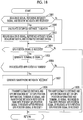
- the ECU 27 of the smartphone 25 owned by the driver of the taxi T executes processing of the flowchart shown in FIG. 16 repeatedly each time a predetermined time elapses.
- Steps 1601 to 1605 are respectively the same processing as Steps 1401 to 1405, and thus, description of the processing will not be repeated.
- Step 1605 the ECU 27 progresses to Step 1606 and determines whether or not the taxi dedicated application is running.
- Step 1606 If the determination result in Step 1606 is Yes, the ECU 27 progresses to Step 1607 and generates smartphone metadata "#OOTAXI".
- Steps 1608 and 1609 are respectively the same processing as Steps 1508 and 1509, and thus, description of the processing will not be repeated.
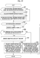
- the ECU 27 of the smartphone 25 owned by the target pedestrian P2-T who is the member of the taxi company executes processing of the flowchart shown in FIG. 17 repeatedly each time a predetermined time elapses.
- Steps 1701 to 1705 are respectively the same processing as Steps 1401 to 1405, and thus, description of the processing will not be repeated.
- Step 1705 the ECU 27 progresses to Step 1706 and determines whether or not the taxi membership application is running and the taxi request button is in the ON state.
- Step 1706 If the determination result in Step 1706 is Yes, the ECU 27 progresses to Step 1707 and generates smartphone metadata "#TAXIKAIIN".
- Steps 1708 and 1709 are respectively the same processing as Steps 1508 and 1509, and thus, description of the processing will not be repeated.
- the ECU 27 of the smartphone 25 owned by the driver of the bus B executes processing of the flowchart shown in FIG. 18 repeatedly each time a predetermined time elapses.
- Steps 1801 to 1805 are respectively the same processing as Steps 1401 to 1405, and thus, description of the processing will not be repeated.
- Step 1805 the ECU 27 progresses to Step 1806 and determines whether or not the bus dedicated application is running.
- Step 1806 If the determination result in Step 1806 is Yes, the ECU 27 progresses to Step 1807 and generates smartphone metadata "#OOBUS".
- Steps 1808 and 1809 are respectively the same processing as Steps 1508 and 1509, and thus, description of the processing will not be repeated.
- the ECU 27 of the smartphone 25 owned by the target pedestrian P2-B who is the member of the bus company executes processing of the flowchart shown in FIG. 19 repeatedly each time a predetermined time elapses.
- Steps 1901 to 1905 are respectively the same processing as Steps 1401 to 1405, and thus, description of the processing will not be repeated.
- Step 1905 the ECU 27 progresses to Step 1906 and determines whether or not the bus membership application is running and the bus waiting button is in the ON state.
- Step 1906 If the determination result in Step 1906 is Yes, the ECU 27 progresses to Step 1907 and generates smartphone metadata "#BUSKAIIN".
- Steps 1908 and 1909 are respectively the same processing as Steps 1508 and 1509, and thus, description of the processing will not be repeated.
- the information processing apparatus 34 of the government building 33 of the XYZ city executes processing of the flowchart shown in FIG. 20 repeatedly each time a predetermined time elapses.
- Step 2001 the information processing apparatus 34 generates request information "the position information associated with the hashtag "#XYZ-MATSURI” and the position information of the smartphone 25, which sends the hashtag "#MACHIAWASE”, are desired” and transmits the request information to the information processing apparatus 16. In a case where the processing of Step 2001 ends, the information processing apparatus 34 ends this routine once.
- the information processing apparatus 41 of the office building 40 of the taxi company executes processing of the flowchart shown in FIG. 21 repeatedly each time a predetermined time elapses.
- Step 2101 the information processing apparatus 41 generates the request information "the position information associated with smartphone metadata "#OOTAXI” and the position information associated with smartphone metadata "#TAXIKAIIN” are desired” and transmits the request information to the information processing apparatus 16. In a case where the processing of Step 2101 ends, the information processing apparatus 41 ends this routine once.
- the information processing apparatus 51 of the office building 50 of the bus company executes processing of the flowchart shown in FIG. 22 repeatedly each time a predetermined time elapses.
- Step 2201 the information processing apparatus 51 generates the request information "the position information associated with smartphone metadata "#OOBUS” and the position information associated with smartphone metadata "#BUSKAIIN” are desired” and transmits the request information to the information processing apparatus 16. In a case where the processing of Step 2201 ends, the information processing apparatus 51 ends this routine once.
- the information processing apparatus 16 of the data center 15 executes processing of the flowchart shown in FIG. 23 repeatedly each time a predetermined time elapses.
- Step 2301 the information processing apparatus 16 determines whether or not the estimated distance and GPS information set and the terminal ID signal are received from a plurality of smartphones 25. In a case where the determination result in Step 2301 is No, the information processing apparatus 16 ends this routine once.
- Step 2301 the information processing apparatus 16 progresses to Step 2302 and obtains the estimated position A-C of the beacon 20 according to the above-described procedure.
- Step 2302 the information processing apparatus 16 progresses to Step 2303 and displays the estimated position A-C on the map image of the display 18.
- Step 2303 the information processing apparatus 16 progresses to Step 2304 and determines whether or not the estimated distance and GPS information set (or the GPS position information) and the terminal ID signal are received from at least one smartphone 25. In a case where the determination result in Step 2304 is No, the information processing apparatus 16 ends this routine once.
- Step 2304 the information processing apparatus 16 progresses to Step 2305 and records the estimated distance and GPS information set (or the GPS position information) and the terminal ID signal in the RAM.
- the information processing apparatus 16 displays the position of the smartphone 25 based on the GPS position information on the map image.
- Step 2305 the information processing apparatus 16 progresses to Step 2306 and determines whether or not smartphone metadata (hashtag) is received from the smartphone 25.
- Step 2306 the information processing apparatus 16 progresses to Step 2307 and records the received smartphone metadata in the memory (RAM) in association with the estimated distance and GPS information set (or the GPS position information) and the terminal ID signal. In a case where the determination result in Step 2306 is No, the information processing apparatus 16 ends this routine once.
- Step 2307 the information processing apparatus 16 progresses to Step 2308 and determines whether or not the request information (the request information replaced with the "#MACHIAWASE") is received from any of the smartphone 25, the information processing apparatus 34 of the government building 33, the information processing apparatus 41 of the office building 40, and the information processing apparatus 51 of the office building 50.
- the request information the request information replaced with the "#MACHIAWASE"
- Step 2308 the information processing apparatus 16 progresses to Step 2309 and transmits the position information of the beacon 20 or/and smartphone 25 corresponding to the request information and the ID information (beacon ID signal and/or terminal ID information) to at least one of the smartphone 25, the information processing apparatus 34, the information processing apparatus 41, or the information processing apparatus 51 as a transmission source of the request information.
- the processing of Step 2309 ends, the information processing apparatus 16 ends this routine once.
- the ECU 27 of the smartphone 25 owned by the target pedestrian P2-M who is the sightseer of the festival further executes processing of the flowchart shown in FIG. 24 repeatedly each time a predetermined time elapses.
- Step 2401 the ECU 27 determines whether or not the festival information acquisition application is running and the festival current position acquisition button is in the ON state.
- Step 2401 the ECU 27 progresses to Step 2402 and determines whether or not the position information and the beacon ID signal of the beacon 20 are received from the information processing apparatus 16.
- Step 2402 the ECU 27 progresses to Step 2403 and displays the current position of the beacon 20 on the display 31 based on the received position information and beacon ID signal.
- Step 2403 ends and in a case where the determination result in Step 2401 or 2402 is No, the ECU 27 ends this routine once.
- the ECU 27 of the smartphone 25 owned by the target pedestrian P2-F who is meeting with an acquaintance further executes processing of the flowchart shown in FIG. 25 repeatedly each time a predetermined time elapses.
- Step 2501 the ECU 27 determines whether or not the meeting application is running and the acquaintance current position acquisition button is in the ON state.
- Step 2501 the ECU 27 progresses to Step 2502 and determines whether or not the position information and the terminal ID signal of the smartphone 25 (that is, the smartphone 25 which sends #MACHIAWASE) of the acquaintance are received from the information processing apparatus 16.
- Step 2502 the ECU 27 progresses to Step 2503 and displays the current position of the smartphone 25 of the acquaintance based on the received position information and terminal ID signal.
- Step 2503 ends and in a case where the determination result in Step 2501 or 2502 is No, the ECU 27 ends this routine once.
- the information processing apparatus 34 of the government building 33 further executes processing of the flowchart shown in FIG. 26 repeatedly each time a predetermined time elapses.
- the information processing apparatus 34 determines whether or not the position information and the ID information (beacon ID signal and/or terminal ID signal) of the beacon 20, which transmits beacon metadata "#XYZ-MATSURI", and/or the smartphone 25, which transmits smartphone metadata "#MACHIAWASE", are received from the information processing apparatus 16.
- Step 2601 the information processing apparatus 34 progresses to Step 2602 and displays the current positions of the beacon 20, which transmits "#XYZ-MATSURI", and the smartphone 25, which transmits smartphone metadata "#MACHIAWASE”, on the display 35 based on the received position information and ID information.
- Step 2601 determines whether the determination result in Step 2601 is No or in a case where the processing of Step 2602 ends.
- the information processing apparatus 41 of the office building 40 of the taxi company further executes processing of the flowchart shown in FIG. 27 repeatedly each time a predetermined time elapses.
- Step 2701 the information processing apparatus 41 determines whether or not the position information and the terminal ID signal of the smartphone 25, which transmits smartphone metadata "#OOTAXI", are received from the information processing apparatus 16.
- Step 2701 the information processing apparatus 41 progresses to Step 2702 and displays the current position of the smartphone 25, which transmits "#OOTAXI", on the display 43 based on the received position information and terminal ID signal.
- Step 2702 In a case where the processing of Step 2702 ends or in a case where the determination result in Step 2701 is No, the information processing apparatus 41 progresses to Step 2703 and determines whether or not the position information and the terminal ID signal of the smartphone 25, which transmits smartphone metadata "#TAXIKAIIN", are received from the information processing apparatus 16.
- Step 2703 the information processing apparatus 41 progresses to Step 2704 and displays the current position of the smartphone 25, which transmits "#TAXIKAIIN", on the display 43 based on the received position information and terminal ID signal.
- Step 2704 ends or in a case where the determination result in Step 2703 is No, the information processing apparatus 41 ends this routine once.
- the ECU 27 of the smartphone 25 owned by the target pedestrian P2-T who is the member of the taxi company further executes processing of the flowchart shown in FIG. 28 repeatedly each time a predetermined time elapses.
- Step 2801 the ECU 27 determines whether or not the taxi membership application is running and the taxi request button is in the ON state.
- Step 2801 the ECU 27 progresses to Step 2802 and determines whether or not the position information and the terminal ID signal of the smartphone 25, which transmits "#OOTAXI", are received from the information processing apparatus 16.
- Step 2802 the ECU 27 progresses to Step 2803 and displays the current position of the smartphone 25, which transmits "#OOTAXI", on the display 31 based on the received position information and terminal ID signal.
- Step 2803 ends or in a case where the determination result in Step 2801 or 2802 is No, the ECU 27 ends this routine once.
- the information processing apparatus 51 of the office building 50 of the bus company further executes processing of the flowchart shown in FIG. 29 repeatedly each time a predetermined time elapses.
- Step 2901 the information processing apparatus 51 determines whether or not the position information and the terminal ID signal of the smartphone 25, which transmits smartphone metadata "#OOBUS", are received from the information processing apparatus 16.
- Step 2901 the information processing apparatus 51 progresses to Step 2902 and displays the current position of the smartphone 25, which transmits "#OOBUS", on the display 53 based on the received position information and terminal ID signal.
- Step 2902 In a case where the processing of Step 2902 ends or in a case where the determination result in Step 2901 is No, the information processing apparatus 51 progresses to Step 2903 and determines whether or not the position information and the terminal ID signal of the smartphone 25, which transmits smartphone metadata "#BUSKAIIN", are received from the information processing apparatus 16.
- Step 2903 the information processing apparatus 51 progresses to Step 2904 and displays the current position of the smartphone 25, which transmits "#BUSKAIIN", on the display 53 based on the received position information and terminal ID signal.
- Step 2904 ends or in a case where the determination result in Step 2903 is No, the information processing apparatus 51 ends this routine once.
- the ECU 27 of the smartphone 25 owned by the target pedestrian P2-B who is the member of the bus company further executes processing of the flowchart shown in FIG. 30 repeatedly each time a predetermined time elapses.
- Step 3001 the ECU 27 determines whether or not the bus membership application is running and the bus waiting button is in the ON state.
- Step 3001 the ECU 27 progresses to Step 3002 and determines whether or not the position information and the terminal ID signal of the smartphone 25, which transmits "#OOBUS", are received from the information processing apparatus 16.
- Step 3002 the ECU 27 progresses to Step 3003 and displays the current position of the smartphone 25, which transmits "#OOBUS", on the display 31 based on the received position information and terminal ID signal.
- Step 3003 ends or in a case where the determination result in Step 3001 or 3002 is No, the ECU 27 ends this routine once.
- the types of mobile objects moving along with the position information sources are not limited to those in the foregoing embodiment.
- trains, bicycles, and the like moving along with the position information sources may be mobile objects.
- the position information sources are not limited to the beacons 20 and the smartphones 25.
- tablet computers and/or notebook computers are available as position information sources.
- electronic apparatuses integrated with vehicles may be used as position information sources.
- the information terminals are not limited to the smartphone 25, the information processing apparatus 34, the information processing apparatus 41, and the information processing apparatus 51.
- tablet computers and/or notebook computers are available as information terminals.
- One position information source may send a plurality of types of metadata.
- objects other than the hashtag may be used.
- the information processing apparatus 16 may transmit, to each position information source (for example, the smartphone 25), movement history information (time-series position information) of the position information source.
- position information source for example, the smartphone 25
- movement history information time-series position information
- the information terminals owned by the drivers of the taxies T of a plurality of taxi companies may send the same metadata (for example, "#OOTAXI"), and the information terminals owned by the members of the taxi companies may send the same metadata (for example, "#TAXIKAIIN”). In this manner, the members of the taxi companies can get on the taxies T within a shorter time.
- the information terminals owned by the drivers of the buses B of a plurality of bus companies may send the same metadata (for example, "#OOBUS"), and the information terminals owned by the members of the bus companies may send the same metadata (for example, "#BUSKAIIN").
- the position information source (for example, the smartphone 25) may include an antenna configured to receive information from satellites of a global navigation satellite system (for example, Galileo) other than the GPS.
- a global navigation satellite system for example, Galileo
- the position information source for example, the smartphone 25
- the information terminal for example, the smartphone 25
- the position information source may encrypt (code) the hashtag.
- the position information common management system 10 and the information terminal for example, the smartphone 25
- a character string constituting the hashtag may be known to a specified user (for example, an employee of the taxi company) and the character string may be constituted of a large number of characters. In this manner, a person (for example, an employee of a private company different from the taxi company) other than the specified user cannot substantially gather position information of mobile objects with a hashtag as metadata.
- fixed transmission and reception means may be used.
- An example of the fixed transmission and reception means is a security camera which is provided in the area represented by the dynamic map DM and has a function of transmitting and receiving electric waves.
Landscapes
- Engineering & Computer Science (AREA)
- Business, Economics & Management (AREA)
- Human Resources & Organizations (AREA)
- Entrepreneurship & Innovation (AREA)
- Strategic Management (AREA)
- Physics & Mathematics (AREA)
- General Physics & Mathematics (AREA)
- Theoretical Computer Science (AREA)
- Computer Networks & Wireless Communication (AREA)
- Tourism & Hospitality (AREA)
- General Business, Economics & Management (AREA)
- Economics (AREA)
- Marketing (AREA)
- Signal Processing (AREA)
- Operations Research (AREA)
- Quality & Reliability (AREA)
- Data Mining & Analysis (AREA)
- Radar, Positioning & Navigation (AREA)
- Remote Sensing (AREA)
- General Health & Medical Sciences (AREA)
- Health & Medical Sciences (AREA)
- Primary Health Care (AREA)
- Databases & Information Systems (AREA)
- General Engineering & Computer Science (AREA)
- Traffic Control Systems (AREA)
- Navigation (AREA)
- Information Transfer Between Computers (AREA)
- Management, Administration, Business Operations System, And Electronic Commerce (AREA)
- Telephonic Communication Services (AREA)
Applications Claiming Priority (1)
| Application Number | Priority Date | Filing Date | Title |
|---|---|---|---|
| JP2016163261A JP6460064B2 (ja) | 2016-08-24 | 2016-08-24 | 移動体の位置情報共通管理システム |
Publications (1)
| Publication Number | Publication Date |
|---|---|
| EP3287968A1 true EP3287968A1 (en) | 2018-02-28 |
Family
ID=59677067
Family Applications (1)
| Application Number | Title | Priority Date | Filing Date |
|---|---|---|---|
| EP17186508.2A Withdrawn EP3287968A1 (en) | 2016-08-24 | 2017-08-16 | Position information common management system for mobile object |
Country Status (8)
| Country | Link |
|---|---|
| US (1) | US10527733B2 (zh) |
| EP (1) | EP3287968A1 (zh) |
| JP (1) | JP6460064B2 (zh) |
| KR (1) | KR101981860B1 (zh) |
| CN (1) | CN107801148B (zh) |
| BR (1) | BR102017017138A2 (zh) |
| RU (1) | RU2676027C1 (zh) |
| SG (1) | SG10201706690RA (zh) |
Families Citing this family (3)
| Publication number | Priority date | Publication date | Assignee | Title |
|---|---|---|---|---|
| KR20150073825A (ko) * | 2013-12-20 | 2015-07-01 | 삼성전자주식회사 | 이동 통신 시스템에서 음성 호 설정 시간을 단축시키는 방법 및 장치 |
| JP6731439B2 (ja) * | 2018-03-26 | 2020-07-29 | 株式会社竹中工務店 | 管理システム、及び管理プログラム |
| CN113473483B (zh) * | 2021-06-29 | 2024-05-14 | 航天海鹰机电技术研究院有限公司 | 一种全量用户的定位方法及系统 |
Citations (1)
| Publication number | Priority date | Publication date | Assignee | Title |
|---|---|---|---|---|
| US20120086552A1 (en) * | 2004-02-04 | 2012-04-12 | Contigo Solutions, Inc. | System for, and method of, monitoring the movement of mobile items |
Family Cites Families (17)
| Publication number | Priority date | Publication date | Assignee | Title |
|---|---|---|---|---|
| RU2126174C1 (ru) * | 1997-10-22 | 1999-02-10 | Саломатин Андрей Аркадьевич | Способ определения координат подвижного объекта, способ идентификации абонентов и определения их местоположения и система радиосвязи абонентов с центральной станцией с идентификацией абонентов и определением их местоположения |
| JP3721001B2 (ja) * | 1999-03-12 | 2005-11-30 | 富士通株式会社 | 移動体発見/案内情報提供システム,移動体発見/案内情報提供方法,移動体発見/案内情報提供システムの管理センタおよび移動体用端末,並びにそれらのプログラム記録媒体 |
| JP2002199433A (ja) * | 2000-10-18 | 2002-07-12 | Sony Corp | 通信方法、通信装置およびそのシステム、位置情報提供方法およびその装置 |
| JP2002132645A (ja) | 2000-10-27 | 2002-05-10 | Nippon Telegr & Teleph Corp <Ntt> | 情報提供方法及び情報提供システム |
| JP2002312381A (ja) * | 2001-04-10 | 2002-10-25 | Megafusion Corp | 位置情報システム |
| WO2007149444A2 (en) * | 2006-06-16 | 2007-12-27 | Droplet Technology, Inc. | System, method and apparatus of video processing and applications |
| CN101814070B (zh) | 2009-02-19 | 2013-07-03 | 上海众恒信息产业股份有限公司 | 实现地理信息数据共享的方法及系统 |
| JP5297900B2 (ja) * | 2009-06-04 | 2013-09-25 | Kddi株式会社 | 位置情報管理システム、位置情報管理方法およびプログラム |
| US9218360B2 (en) | 2009-12-11 | 2015-12-22 | Microsoft Technology Licensing, Llc | User-selected tags for annotating geographic domains containing points-of-interest |
| KR101719992B1 (ko) * | 2010-11-16 | 2017-03-27 | 엘지전자 주식회사 | 이동 단말기 및 이것의 메타데이터 활용 방법 |
| JP5863255B2 (ja) | 2011-02-25 | 2016-02-16 | Necパーソナルコンピュータ株式会社 | 携帯端末装置、携帯端末装置の制御方法、及びプログラム |
| CA2829597C (en) * | 2011-03-07 | 2015-05-26 | Kba2, Inc. | Systems and methods for analytic data gathering from image providers at an event or geographic location |
| GB2491038A (en) * | 2011-05-20 | 2012-11-21 | Apple Inc | Managing signage devices for product information |
| JP5573859B2 (ja) * | 2012-02-09 | 2014-08-20 | コニカミノルタ株式会社 | エアタグ情報登録装置、エアタグ情報登録システムおよびプログラム |
| JP5279057B1 (ja) * | 2012-11-09 | 2013-09-04 | 株式会社Kpiソリューションズ | 情報処理システム、及び情報処理方法 |
| JP5852053B2 (ja) | 2013-06-21 | 2016-02-03 | 京セラドキュメントソリューションズ株式会社 | デバイス登録システム |
| JP6359899B2 (ja) | 2013-07-31 | 2018-07-18 | 技研商事インターナショナル株式会社 | 行動ログ分析システム及びそのプログラム |
-
2016
- 2016-08-24 JP JP2016163261A patent/JP6460064B2/ja active Active
-
2017
- 2017-08-10 BR BR102017017138-8A patent/BR102017017138A2/pt not_active Application Discontinuation
- 2017-08-11 RU RU2017128715A patent/RU2676027C1/ru active
- 2017-08-15 CN CN201710696748.3A patent/CN107801148B/zh active Active
- 2017-08-16 EP EP17186508.2A patent/EP3287968A1/en not_active Withdrawn
- 2017-08-16 US US15/678,627 patent/US10527733B2/en active Active
- 2017-08-16 SG SG10201706690RA patent/SG10201706690RA/en unknown
- 2017-08-21 KR KR1020170105262A patent/KR101981860B1/ko active IP Right Grant
Patent Citations (1)
| Publication number | Priority date | Publication date | Assignee | Title |
|---|---|---|---|---|
| US20120086552A1 (en) * | 2004-02-04 | 2012-04-12 | Contigo Solutions, Inc. | System for, and method of, monitoring the movement of mobile items |
Non-Patent Citations (1)
| Title |
|---|
| PÅL KASTNES: "Introducing nearables: Personal portable beacons", 16 August 2016 (2016-08-16), XP055433099, Retrieved from the Internet <URL:https://blog.nordicsemi.com/getconnected/introducing-nearables-personal-portable-beacons> [retrieved on 20171207] * |
Also Published As
| Publication number | Publication date |
|---|---|
| JP6460064B2 (ja) | 2019-01-30 |
| KR101981860B1 (ko) | 2019-05-23 |
| SG10201706690RA (en) | 2018-03-28 |
| KR20180022585A (ko) | 2018-03-06 |
| CN107801148A (zh) | 2018-03-13 |
| CN107801148B (zh) | 2020-08-11 |
| US10527733B2 (en) | 2020-01-07 |
| US20180059249A1 (en) | 2018-03-01 |
| JP2018032181A (ja) | 2018-03-01 |
| RU2676027C1 (ru) | 2018-12-25 |
| BR102017017138A2 (pt) | 2018-05-02 |
Similar Documents
| Publication | Publication Date | Title |
|---|---|---|
| KR102325049B1 (ko) | 보행자의 안전과 연관된 통신 신호를 송신하는 전자 장치 및 그 동작 방법 | |
| Xiong et al. | Intelligent transportation systems for smart cities: a progress review | |
| CN101517432B (zh) | 用于利用跟踪装置定位个体和物体的设备和方法 | |
| US10527733B2 (en) | Position information common management system for mobile object | |
| CN107101647B (zh) | 使用低功率无线电装置的机动车辆导航 | |
| US20160335896A1 (en) | Vehicle Finder | |
| JP6296510B2 (ja) | 移動物体の位置検索登録システム | |
| Mancini et al. | Embedded multisensor system for safe point-to-point navigation of impaired users | |
| Kamble et al. | Bus tracking and monitoring using RFID | |
| US10540890B2 (en) | Construction-related information estimation system | |
| US20220371544A1 (en) | Passenger authentication and entry for autonomous vehicles | |
| US20200369298A1 (en) | Information processing apparatus, information processing method and program | |
| JP2014044740A (ja) | 移動体監視装置 | |
| Korbel et al. | A radio network for guidance and public transport assistance of the visually impaired | |
| CN206584047U (zh) | 一种移动巡特警终端 | |
| US11899446B2 (en) | Verifying authorized personnel for interaction with autonomous vehicles | |
| Osman et al. | Enhancement of Public Transportation Services Using Wireless Technologies | |
| JP7318526B2 (ja) | 情報処理装置、情報処理方法及びプログラム | |
| Vanmore et al. | Smart vehicle tracking using GPS | |
| Kumar et al. | Wireless Sensor Network based Intelligent Urban Transportation System | |
| Krzykowska-Piotrowska et al. | Companion robot communication with road infrastructure as part of IoRT | |
| KUMAR | A Real Time Prototype for Vehicle Tracking and Alerting System | |
| Ben Khadra | Road Traffic Management using Vehicle-to-Everything (V2X) Communication | |
| GOLLA et al. | A BLIND NAVIGATION SYSTEM USING RFID FOR INDOOR & OUTDOOR ENVIRONMENTS | |
| Talledo Vilela et al. | Smart Work Zone System |
Legal Events
| Date | Code | Title | Description |
|---|---|---|---|
| PUAI | Public reference made under article 153(3) epc to a published international application that has entered the european phase |
Free format text: ORIGINAL CODE: 0009012 |
|
| STAA | Information on the status of an ep patent application or granted ep patent |
Free format text: STATUS: REQUEST FOR EXAMINATION WAS MADE |
|
| 17P | Request for examination filed |
Effective date: 20170816 |
|
| AK | Designated contracting states |
Kind code of ref document: A1 Designated state(s): AL AT BE BG CH CY CZ DE DK EE ES FI FR GB GR HR HU IE IS IT LI LT LU LV MC MK MT NL NO PL PT RO RS SE SI SK SM TR |
|
| AX | Request for extension of the european patent |
Extension state: BA ME |
|
| STAA | Information on the status of an ep patent application or granted ep patent |
Free format text: STATUS: EXAMINATION IS IN PROGRESS |
|
| 17Q | First examination report despatched |
Effective date: 20200302 |
|
| STAA | Information on the status of an ep patent application or granted ep patent |
Free format text: STATUS: THE APPLICATION HAS BEEN WITHDRAWN |
|
| 18W | Application withdrawn |
Effective date: 20200625 |