EP2656251B1 - Generating maps of private spaces using mobile computing device sensors - Google Patents
Generating maps of private spaces using mobile computing device sensors Download PDFInfo
- Publication number
- EP2656251B1 EP2656251B1 EP11851285.4A EP11851285A EP2656251B1 EP 2656251 B1 EP2656251 B1 EP 2656251B1 EP 11851285 A EP11851285 A EP 11851285A EP 2656251 B1 EP2656251 B1 EP 2656251B1
- Authority
- EP
- European Patent Office
- Prior art keywords
- sensor data
- private space
- location
- data
- mobile computing
- Prior art date
- Legal status (The legal status is an assumption and is not a legal conclusion. Google has not performed a legal analysis and makes no representation as to the accuracy of the status listed.)
- Active
Links
Images


Classifications
-
- G—PHYSICS
- G01—MEASURING; TESTING
- G01C—MEASURING DISTANCES, LEVELS OR BEARINGS; SURVEYING; NAVIGATION; GYROSCOPIC INSTRUMENTS; PHOTOGRAMMETRY OR VIDEOGRAMMETRY
- G01C21/00—Navigation; Navigational instruments not provided for in groups G01C1/00 - G01C19/00
- G01C21/20—Instruments for performing navigational calculations
- G01C21/206—Instruments for performing navigational calculations specially adapted for indoor navigation
-
- G—PHYSICS
- G06—COMPUTING OR CALCULATING; COUNTING
- G06F—ELECTRIC DIGITAL DATA PROCESSING
- G06F17/00—Digital computing or data processing equipment or methods, specially adapted for specific functions
- G06F17/40—Data acquisition and logging
-
- G—PHYSICS
- G01—MEASURING; TESTING
- G01C—MEASURING DISTANCES, LEVELS OR BEARINGS; SURVEYING; NAVIGATION; GYROSCOPIC INSTRUMENTS; PHOTOGRAMMETRY OR VIDEOGRAMMETRY
- G01C21/00—Navigation; Navigational instruments not provided for in groups G01C1/00 - G01C19/00
- G01C21/38—Electronic maps specially adapted for navigation; Updating thereof
- G01C21/3804—Creation or updating of map data
- G01C21/3833—Creation or updating of map data characterised by the source of data
- G01C21/3841—Data obtained from two or more sources, e.g. probe vehicles
-
- G—PHYSICS
- G09—EDUCATION; CRYPTOGRAPHY; DISPLAY; ADVERTISING; SEALS
- G09B—EDUCATIONAL OR DEMONSTRATION APPLIANCES; APPLIANCES FOR TEACHING, OR COMMUNICATING WITH, THE BLIND, DEAF OR MUTE; MODELS; PLANETARIA; GLOBES; MAPS; DIAGRAMS
- G09B29/00—Maps; Plans; Charts; Diagrams, e.g. route diagram
- G09B29/10—Map spot or coordinate position indicators; Map reading aids
- G09B29/106—Map spot or coordinate position indicators; Map reading aids using electronic means
-
- G—PHYSICS
- G06—COMPUTING OR CALCULATING; COUNTING
- G06F—ELECTRIC DIGITAL DATA PROCESSING
- G06F16/00—Information retrieval; Database structures therefor; File system structures therefor
- G06F16/90—Details of database functions independent of the retrieved data types
- G06F16/903—Querying
- G06F16/9032—Query formulation
- G06F16/90324—Query formulation using system suggestions
- G06F16/90328—Query formulation using system suggestions using search space presentation or visualization, e.g. category or range presentation and selection
Definitions
- a method of mapping a location of an event that is scheduled in a calendar application includes steps of identifying a contact associated with the event, determining address information associated with the contact, obtaining map data for the address information, and generating a map of the location associated with the contact based on the map data. If no address information is provided (or the address information is insufficient), relevantaddress information is extracted from one or more contacts invited to the event.
- a contact is a person for whom contact information is available either locally or remotely, such as a person for whom address information is stored in an address book or contact list.
- the location of a previous event having related attributes can be used to determine the probable location of the next (“related") event.
- a map generation system comprising: a mobile device for acquiring location data of a vehicle and a status of the vehicle at a time of acquisition of the location; and a server for processing the acquired location data of the vehicle.
- the server includes a management unit for collecting a plurality of pieces of the track data obtained by a motion of the vehicle, an extraction unit for extracting feature points of the plurality of pieces of the track data on a road from which the plurality of pieces of the track data are collected to calculate a Spline curve satisfying the extracted feature points, and an update unit for adding the calculated Spline curve as a lane central line to the digital road map to update map data.
- pieces of GPS track data collected by a vehicle motion and recorded in the vehicle are used to generate a correct and detailed road map.
- the GPS track data is used to update the central map database.
- Embodiments are provided for generating maps of private spaces using mobile computing device sensors.
- Sensor data may be received from one or more mobile computing devices to determine a digital signature describing a private space.
- Scheduling data may also be received from the one or more mobile devices.
- the scheduling data may describe a location associated with the private space to be mapped.
- a digital map of the private space may then be generated from the digital signature and the location associated with the private space in the scheduling data.
- FIGURE 1 is a block diagram illustrating a network architecture for generating maps of private spaces using mobile computing device sensors, in accordance with various embodiments.
- the network architecture includes mobile computing devices 2A-2C which may be in communication with client computing devices 6A-6B and server 70 over a network 4.
- the network 4 may comprise a local network or a wide area network (e.g., the Internet).
- the mobile computing devices 2A-2C may include sensors 40A-40C and scheduling data 42A-42C, respectively.
- the mobile computing device 2 may comprise a mobile telephone, "smartphone," tablet or laptop computer which is capable of executing one or more application programs.
- a “smartphone” may comprise a mobile phone having computer functionality and/or which is capable of running operating system software to provide a standardized interface and platform for application developers.
- the sensors 40A-40C (which may be in or connected to) the mobile computing devices 2A-2C may be capable of measuring/detecting a number of types of data associated with the mobile computing devices 2A-2C including, but not limited to, altitude, location, signal strength, orientation and force.
- the sensors 40A-40C may also comprise the ability to detect the presence of a wireless network (e.g., a "Wi-Fi" network), Wi-Fi access point or other mobile computing devices (e.g., via BLUETOOTH wireless technology) without actually making a network or a device connection).
- a wireless network e.g., a "Wi-Fi" network
- Wi-Fi access point e.g., via BLUETOOTH wireless technology
- the sensors 40A-40C may include an altimeter, a GPS, a wireless network interface device (for signal strength detection and for detecting and connecting to other wireless networks/devices), a gyroscope, and a force sensor.
- the sensors 40A-40C may be utilized to create a "digital signature" for mapping a private space (e.g., a conference room in an office building) in accordance with various embodiments. It should be understood, in accordance with and embodiment, that the sensors 40A-40C may not necessarily be physically connected to the mobile computing devices 2A-2C but may connected wirelessly for the exchange of data.
- the sensors 40A-40C may comprise self-powering (e.g., photovoltaic) sensors that may be attached to a wall and broadcast measurement data (e.g., location information) utilizing any of a number of low power wireless communication technologies known to those skilled in the art.
- the sensors 40A-40C may utilize BLUETOOTH wireless technology the suite of low power communication protocols based on the ZIGBEE specification.
- the scheduling data 42A-42C may comprise location based information found in the respective schedules of users associated with the mobile computing devices 2A-2C.
- the scheduling data 42A-42C may comprise location data compiled by a scheduling service on the server 70.
- the scheduling data 42A-42C may identify a 3PM meeting in conference room "J" of an office building, for users of the mobile computing devices 2A-2C.
- the location data in the scheduling data 42A-42C may be communicated in a payload over a communication channel from the mobile computing devices 2A-2C to the server 70.
- the communication channel may comprise the EXCHANGE ACTIVESYNC protocol developed by MICROSOFT CORPORATION of Redmond, Washington.
- the location data in the scheduling data 42A-42C may be utilized, in combination with data measured by the sensors 40A-40C, to generate maps of private spaces.
- the generation of maps, as defined herein includes enhancing publically available maps with private spaces information.
- the publically available maps may be provided by an online web service, such as the BING MAPS web mapping service from MICROSOFT CORPORATION of Redmond, Washington.
- private spaces may include, but are not limited to, various locations, including individual offices and meeting rooms (e.g., conference rooms and auditoriums) in a building or buildings within the grounds of a business enterprise to which the general public (i.e., public mapping companies) lack physical access and/or access to the names of the various locations contained therein.
- the client computing devices 6A-6B may include sensors 40D-40E and scheduling data 42D-42E, respectively, which may be similar to the sensors 40A-40C and the scheduling data 42A-42C in the mobile computing devices 2A-2C (discussed above).
- the client computing devices 2 may comprise a desktop or workstation computer which is capable of executing one or more application programs.
- the client computing devices 6A-6B may also be utilized as sensor inputs in conjunction with, and in the same manner as, the mobile computing devices 2A-2C, with respect to mapping private spaces.
- the server 70 may comprise a mapping and scheduling service application 72 and a map database 74.
- the server 70 may provide both a private mapping service and a private scheduling service for scheduling and mapping private locations associated with users of the mobile computing devices 2A-2C and the client computing devices 6A-6B.
- the private mapping service and the private scheduling service may comprise a single combined service or, alternatively, two separate services.
- the server 70 may represent services hosted on multiple servers or other complex computer systems.
- the mapping and scheduling service application 72 may be configured to generate maps of private spaces using sensor data collected from the mobile sensors 40A-40C (and optionally the sensors 40D-40E) as well as the scheduling data 42A-42C (and optionally the scheduling data 42D-42E).
- the mapping and scheduling service application 72 may be configured to gather sensor and location data from the mobile computing devices 2A-2C (and optionally the computing devices 6A-6B) and run a statistical analysis to assign location names (and the electronic definition thereof) with a higher than average degree of certainty.
- mapping and scheduling service application 72 may be configured to leverage large numbers of connected mobile devices to "crowd source" the naming of private spaces by using statistics (i.e., density of information at a given time and over a period of time) to determine the actual naming of private spaces.
- the mapping and scheduling service application 72 may comprise a collaborative server application such as the EXCHANGE SERVER collaborative application from MICROSOFT CORPORATION of Redmond, Washington. It should be appreciated that other collaborative server applications from other manufacturers may be utilized in accordance with the various embodiments described herein.
- the map database 74 may store maps 76, 78 and 80.
- the maps 76, 78 and 80 may represent digital maps of private spaces generated by the mapping and scheduling service application 72 using received sensor data collected from the mobile sensors 40A-40C (and optionally the sensors 40D-40E) and location data received from the scheduling data 42A-42C (and optionally the scheduling data 42D-42E). It should be understood that the maps 76, 78 and 80 may comprise publically available maps (such as those provided by an online mapping service) which are "tagged" or enhanced with private space sensor data and location data determined by the mapping and scheduling service application 72.
- the "generation" of digital maps of private spaces may include enhancing or tagging publically available maps with private space information (i.e., the gathered sensor and location data from the mobile computing devices 2A-2C (and optionally the computing devices 6A-6B)). It should further be understood that the enhanced or tagged public maps may not be re-shared with the online mapping service from which they were retrieved or otherwise made public, thereby insuring their privacy.
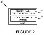
- FIGURE 2 is a block diagram illustrating the components of a digital map 76, generated by the mapping and scheduling service application 72, for a private space using mobile computing device sensors, in accordance with various embodiments.
- the map 76 includes sensor data 82 which may represent a digital signature of a private space.
- the sensor data 82 may include data collected from the sensors 40A-40C in the mobile computing devices 2A-2C associated with the name of a single location identified as location data 84 which in turn may be collected from the scheduling data 42A-42C.
- the location data 84 may include a name for a mapped private space and may be obtained from information contained in the scheduling data 42A-42C (e.g., the name of a conference room for a scheduled meeting) or from nicknames or other colloquialisms for a private space which may be utilized by users of the mobile computing devices 2A-2C.
- FIGURE 3 the following discussion is intended to provide a brief, general description of a suitable computing environment in which various illustrative embodiments may be implemented. While various embodiments will be described in the general context of program modules that execute in conjunction with program modules that run on an operating system on a computing device, those skilled in the art will recognize that the various embodiments may also be implemented in combination with other types of computer systems and program modules.
- program modules include routines, programs, components, data structures, and other types of structures that perform particular tasks or implement particular abstract data types.
- program modules may be located in both local and remote memory storage devices.
- FIGURE 3 shows the server 70 which may include a computer capable of executing one or more application programs.
- the server 70 includes at least one central processing unit 8 ("CPU"), a system memory 12, including a random access memory 18 (“RAM”) and a read-only memory (“ROM”) 20, and a system bus 10 that couples the memory to the CPU 8.
- CPU central processing unit 8
- RAM random access memory 18
- ROM read-only memory
- the server 70 may further include a mass storage device 14 for storing an operating system 32, the mapping and scheduling service application 72 and the map database 74 (including the maps 76, 78 and 80).
- the operating system 32 may be suitable for controlling the operation of a networked computer, such as the WINDOWS operating systems from MICROSOFT CORPORATION of Redmond, Washington.
- the mass storage device 14 is connected to the CPU 8 through a mass storage controller (not shown) connected to the bus 10.
- the mass storage device 14 and its associated computer-readable media provide non-volatile storage for the server 70.
- the term computer-readable media as used herein may include computer storage media.
- Computer storage media may include volatile and nonvolatile, removable and non-removable media implemented in any method or technology for storage of information, such as computer readable instructions, data structures, program modules, or other data.
- Computer storage media may include, but is not limited to, RAM, ROM, electrically erasable read-only memory (EEPROM), flash memory or other memory technology, CD-ROM, digital versatile disks (DVD) or other optical storage, magnetic cassettes, magnetic tape, magnetic disk storage or other magnetic storage devices, or any other medium which can be used to store information and which can be accessed by the server 70. Any such computer storage media may be part of the server 70.
- Computer-readable media may also include communication media.
- Communication media may be embodied by computer readable instructions, data structures, program modules, or other data in a modulated data signal, such as a carrier wave or other transport mechanism, and includes any information delivery media.
- modulated data signal may describe a signal that has one or more characteristics set or changed in such a manner as to encode information in the signal.
- communication media may include wired media such as a wired network or direct-wired connection, and wireless media such as acoustic, radio frequency (RF), infrared, and other wireless media.
- RF radio frequency
- the server 70 may operate in a networked environment using logical connections to remote computers through the network 4.
- the server 70 may connect to the network 4 through a network interface unit 16 connected to the bus 10. It should be appreciated that the network interface unit 16 may also be utilized to connect to other types of networks and remote computing systems.
- the availability server 70 may also include an input/output controller 22 for receiving and processing input from a number of input types, including a keyboard, mouse, pen, stylus, finger, and/or other means (not shown). Similarly, the input/output controller 22 may provide output to a display device 85 as well as a printer, or other type of output device (not shown).
- the mobile computing devices 2A-2C and the client computing devices 6A-6B, shown in FIGURE 1 may include many of the conventional components shown and discussed above with respect to the availability server 70.
- the mobile computing devices 2A-2C may also include additional conventional components (not shown) such as a wireless radio, a power supply (e.g., a removable or non-removable battery), an array of various sensors and a real-time clock.
- FIGURE 4 is a flow diagram illustrating a routine 400 for gathering sensor data for use in generating maps of private spaces, in accordance with various embodiments.
- routines for gathering sensor data for use in generating maps of private spaces.
- FIGURE 4 is a flow diagram illustrating a routine 400 for gathering sensor data for use in generating maps of private spaces, in accordance with various embodiments.
- the logical operations of various embodiments of the present invention are implemented (1) as a sequence of computer implemented acts or program modules running on a computing system and/or (2) as interconnected machine logical circuits or circuit modules within the computing system.
- the implementation is a matter of choice dependent on the performance requirements of the computing system implementing the invention. Accordingly, the logical operations illustrated in FIGURES 4-5 and making up the various embodiments described herein are referred to variously as operations, structural devices, acts or modules.
- the routine 400 begins at operation 405, where the mapping and scheduling application 72 (hereinafter referred to as the "application 72"), executing on the server 70, receives mobile device sensor data to determine a digital signature.
- the application 72 may receive sensor data measured by the sensors in one or more of the mobile computing devices 2A-2C to determine a digital signature describing a private space.
- the sensor data (as well as location data) may always be sent from the mobile computing devices 2A-2C to the server 70 as sensor data is being detected by the sensors 40A-40C.
- the sensor data (as well as location data) may be sent only after the application 72 prompting the users of the mobile computing devices 2A-2C.
- the sensor data may be sent at appropriate intervals as determined by the application 72.
- the application 72 may also require a one-time user consent for the sending of the sensor data (as well as location data) from the mobile computing devices 2A-2C to the server 70 for all future interactions, prompt users before every request to send the sensor data (as well as the location data), or require users to trigger the sending of the sensor data (as well as the location data) to the server 70.
- privacy and legal considerations in different geographical locations may be relied upon for determining the collection of the sensor data (as well as the location data) by the application 72.
- the collection of the sensor and location data, by the application 72 may be temporally restricted to a company's business hours and further geographically restricted to be confined within a company's grounds.
- the routine 400 continues to operation 410, where the application 72 determines if the received sensor data is correlated with a known user.
- the application 72 may determine if the received sensor data corresponds to a user of one of the mobile computing devices 2A, 2B or 2C whose presence in the network is recognized by the server 70. If, at operation 410, the application 72 determines that the received sensor data can be correlated with a known user, then the routine 400 continues to operation 415. If however, at operation 410, the application 72 determines that the received sensor data cannot be correlated with a known user, then the routine 400 branches to operation 430.
- the application 72 determines whether the received sensor data can be correlated with user data. For example, the application 72 may compare received sensor data from the mobile computing device 2A to the sensor data previously received from users of the mobile computing devices 2B and 2C to determine if all three devices have the same digital signature. A digital signature may be based on Wi-Fi access point signal strength, altimeter data, GPS data, mobile operator signal strength, etc., as determined by the sensors 40A-40C. If, at operation 415, the application 72 determines that the received sensor data can be correlated with user data, then the routine 400 continues to operation 420. If however, at operation 415, the application 72 determines that the received sensor data cannot be correlated with user data, then the routine 400 branches to operation 430.
- the application 72 receives location data from scheduling data associated with mobile computing device from which the sensor data was received. For example, the application 72 may receive the scheduling data 42A from the mobile computing device 2A whose digital signature was previously determined based on the sensor data 40A.
- the routine 400 continues to operation 425 where the application 72 processes the sensor and scheduling data to generate a digital map.
- the application 72 may build a digital map of the private space (e.g., a conference room) described by the digital signature determined from the sensor data and named as a location in the scheduling data.
- digital maps may be stored in a map database, such as the map database 74. From operation 425, the routine 400 then ends.
- the application 72 determines whether the received sensor data is relevant. For example, if the sensor data was received from a user at 3:10 PM and it can be further determined, by the application 72, from scheduling data associated with the same user that the user has a meeting in conference room "J" from 3 PM to 4 PM, then the application 72 may determine that the sensor data is relevant with respect to the location of conference room J. If, at operation 430, the application 72 determines that the received sensor data is relevant, then the routine 400 returns to operation 425. If however, at operation 430, the application 72 determines that the received sensor data is not relevant, then the routine 400 continues to operation 435 where the received sensor data is discarded. From operation 435, the routine 400 then ends.
- FIGURE 5 is a flow diagram illustrating a routine 500 for the processing of sensor data and the generation of maps of private spaces, in accordance with various embodiments.
- the routine 500 begins at operation 505, where the application 72, executing on the server 70, determines if sensor data received from one or more of the mobile computing devices 2A-2C is completely new data.
- the application 72 may be configured to determine if the received sensor data (i.e., the digital signature) matches a digital signature for a map stored in the map database 74. If, at operation 505, the application 72 determines that the received sensor data is completely new data, then the routine 500 continues to operation 510. If however, at operation 505, the application 72 determines that the received sensor data is not completely new data, then the routine 500 branches to operation 515.
- the application 72 upon determining that the received sensor data is completely new data, creates and stores an entry for the new sensor data in the map database 74.
- the application 72 may determine from scheduling data associated with the mobile computing device from which the new sensor data was received, the name of a location to associate with the new sensor data.
- the application 72 may create a new entry for the aforementioned location (i.e., "Stevens auditorium") and store the received sensor data describing this location in building "K" with the location name "Stevens auditorium.” From operation 510, the routine 500 then ends.
- the application 72 upon determining that the received sensor data is not completely new data, may determine whether the received sensor data can be correlated with a current location at least partially associated with the received sensor data.
- the received sensor data may include augmented GPS sensor data measured by a mobile computing device which has an augmented GPS sensor for measuring the relative forces acting on the device to determine elevation change and travel within a building.
- the received sensor data may also include data identical to sensor data measured by other mobile computing devices which are currently located in the same location as the mobile computing device which has the augmented sensor. If, at operation 515, the application 72 determines that the received sensor data can be correlated with a current location, then the routine 500 continues to operation 520. If however, at operation 515, the application 72 determines that the received sensor data cannot be correlated with a current location, then the routine 500 branches to operation 525.
- the application 72 upon determining that the received sensor data can be correlated with a current location, augments the data for the current location.
- the application 72 may augment the current location and a stored sensor data set for the location with the augmented sensor data (e.g., the augmented GPS sensor data) discussed above with respect to operation 515.
- the augmented sensor data e.g., the augmented GPS sensor data
- the application 72 upon determining that the received sensor data cannot be correlated with a current location, determines whether the sensor data matches another location.
- the application 72 may be configured for "outlier" data detection in which the received sensor data is determined to be irrelevant for a current location.
- application 72 may determine from the scheduling data 42A-42C for mobile computing devices 2A-2C indicate that the users of these devices are scheduled to be in a meeting in conference room "J" at 3:10 PM but may also determined that the sensor data for the mobile computing device 2B indicates that the mobile computing device is in another location (such as the user's office) at the scheduled meeting time.
- the received sensor data from the mobile computing device 2B is dissimilar to the received sensor data from the mobile computing devices 2A and 2C and is irrelevant to the digital definition of conference room "J."
- the received sensor data from the mobile computing device 2B may correlate to another location stored in the map database 74, such as the user's office. If, at operation 525, the application 72 determines that the received sensor data matches another location, then the routine 500 continues to operation 530. If however, at operation 525, the application 72 determines that the received sensor data does not match another location, then the routine 500 branches to operation 535.
- the application 72 upon determining that the received sensor data matches another location, augments the data for the other location and may further request feedback from a user of the mobile computing device from which the sensor data was received. For example, the application 72 may augment the other location associated with the user of the mobile computing device 2B described at operation 525 (above) and a stored sensor data set for the location with augmented sensor data corresponding to the user's office. It should be understood that, in accordance with an embodiment, the application 72 may also be configured to confirm a digital signature by actually querying a user for feedback in order to validate information.
- the application 72 may send a message asking the user of the mobile computing device 2B, who according to the scheduling data 42B is scheduled to be in conference room "J" at 3:10 PM, is currently attending a meeting in the aforementioned conference room (despite the received contrary sensor data). From operation 530, the routine 500 then ends.
- the application 72 upon determining that the received sensor data does not match another location, determines whether the received sensor data is relevant. In particular, the application 72 may determine that the received sensor data corresponds to a sensor data set stored in the map database 74, but that the location data (retrieved from user scheduling data) associated with the received sensor data, is not stored in the map database 74. If, at operation 535, the application 72 determines that the received sensor data is relevant, then the routine 500 returns to operation 510. In accordance with an embodiment, the received sensor data may be determined to be relevant if the location data includes information pertaining to a conference room or an office associated with a place of business.
- the aforementioned situation may occur when a change takes place to a space used by a company's employees. For example, a remodeling project may have recently been undertaken to breakup conference room "J" (and other surrounding rooms) to create a new auditorium.
- the application 72 having not yet been updated, would not immediately know that the conference room is no longer there but would determine over time from scheduling data that the area defined by sensor data as conference room "J" was now being referred to as the "Newton Auditorium.” If, at operation 535, the application 72 determines that the received sensor data is irrelevant, then the routine 500 continues to operation 540.
- the application 72 upon determining that the received sensor data is irrelevant, may discard the received sensor data. For example, the application 72 may determine that the received sensor data corresponds to a sensor data set in the map database 74 but that the user's scheduling data indicates that the user is on vacation or out of the office. This situation may occur, for example, when the user is at her company work site but merely visiting a colleague on an off-day. From operation 540, the routine 500 then ends.
- the application 72 may be configured, in response to receiving augmented sensor (e.g., GPS) data for a private space, to actively query the user of the mobile computing device which provided the augmented sensor data and to further tag the private space with a more precise location so as to improve building navigation, etc.
- augmented sensor e.g., GPS
- users of the mobile computing devices 2A-2C and the client computing devices 6A-6C may be able to delete sensor and/or scheduling data gathered from these devices by the application 72 so as to fulfill legal and privacy requirements which may exist in the users' geographical area.
- the application 72 may be configured to automatically delete entries from the map database 74 which haven't been accessed, augmented or otherwise updated after a predetermined time period has elapsed.
Landscapes
- Engineering & Computer Science (AREA)
- Radar, Positioning & Navigation (AREA)
- Remote Sensing (AREA)
- Physics & Mathematics (AREA)
- General Physics & Mathematics (AREA)
- Theoretical Computer Science (AREA)
- Automation & Control Theory (AREA)
- Mathematical Physics (AREA)
- Business, Economics & Management (AREA)
- Educational Administration (AREA)
- Educational Technology (AREA)
- General Engineering & Computer Science (AREA)
- Data Mining & Analysis (AREA)
- Databases & Information Systems (AREA)
- Software Systems (AREA)
- Computer Hardware Design (AREA)
- Telephonic Communication Services (AREA)
- Mobile Radio Communication Systems (AREA)
- Navigation (AREA)
- Traffic Control Systems (AREA)
Applications Claiming Priority (2)
| Application Number | Priority Date | Filing Date | Title |
|---|---|---|---|
| US12/978,098 US9823078B2 (en) | 2010-12-23 | 2010-12-23 | Generating maps of private spaces using mobile computing device sensors |
| PCT/US2011/065453 WO2012087810A2 (en) | 2010-12-23 | 2011-12-16 | Generating maps of private spaces using mobile computing device sensors |
Publications (3)
| Publication Number | Publication Date |
|---|---|
| EP2656251A2 EP2656251A2 (en) | 2013-10-30 |
| EP2656251A4 EP2656251A4 (en) | 2014-06-04 |
| EP2656251B1 true EP2656251B1 (en) | 2016-08-03 |
Family
ID=46314776
Family Applications (1)
| Application Number | Title | Priority Date | Filing Date |
|---|---|---|---|
| EP11851285.4A Active EP2656251B1 (en) | 2010-12-23 | 2011-12-16 | Generating maps of private spaces using mobile computing device sensors |
Country Status (10)
Families Citing this family (12)
| Publication number | Priority date | Publication date | Assignee | Title |
|---|---|---|---|---|
| US9823078B2 (en) | 2010-12-23 | 2017-11-21 | Microsoft Technology Licensing, Llc | Generating maps of private spaces using mobile computing device sensors |
| US20130145293A1 (en) * | 2011-12-01 | 2013-06-06 | Avaya Inc. | Methods, apparatuses, and computer-readable media for providing availability metaphor(s) representing communications availability in an interactive map |
| KR102003850B1 (ko) * | 2012-06-04 | 2019-07-25 | 삼성전자주식회사 | 단말의 애플리케이션 제공 방법 및 그 단말 |
| US20140201276A1 (en) * | 2013-01-17 | 2014-07-17 | Microsoft Corporation | Accumulation of real-time crowd sourced data for inferring metadata about entities |
| US9307368B1 (en) * | 2013-05-14 | 2016-04-05 | Google Inc. | Automatically generating and maintaining a floor plan |
| US9380425B2 (en) | 2013-12-05 | 2016-06-28 | At&T Mobility Ii Llc | Systems, methods, and computer-readable storage devices for generating and using a radio-frequency map of an area |
| US20150193971A1 (en) * | 2014-01-03 | 2015-07-09 | Motorola Mobility Llc | Methods and Systems for Generating a Map including Sparse and Dense Mapping Information |
| US10803189B2 (en) * | 2016-08-31 | 2020-10-13 | Microsoft Technology Licensing, Llc | Location-based access control of secured resources |
| CN108614852A (zh) * | 2018-03-14 | 2018-10-02 | 广州市优普科技有限公司 | 一种基于大数据的数据地图生成方法 |
| US10887292B2 (en) * | 2018-04-18 | 2021-01-05 | International Business Machines Corporation | Obfuscated haptic interfaces with natural interaction steganography |
| WO2021060894A1 (en) * | 2019-09-24 | 2021-04-01 | Samsung Electronics Co., Ltd. | Method for generating diagrammatic representation of area and electronic device thereof |
| US11778055B2 (en) * | 2020-07-13 | 2023-10-03 | Samsung Electronics Co., Ltd. | Systems and methods for storage-efficient sensors |
Family Cites Families (30)
| Publication number | Priority date | Publication date | Assignee | Title |
|---|---|---|---|---|
| US6857016B1 (en) | 2000-09-25 | 2005-02-15 | Ricoh Company Limited | Method and system of data collection and mapping from a remote position reporting device |
| JP2004240703A (ja) | 2003-02-06 | 2004-08-26 | Hitachi Ltd | 地域施設情報収集・管理・提供システム |
| US7505849B2 (en) * | 2003-05-12 | 2009-03-17 | Nokia Corporation | Navigation tags |
| US7343564B2 (en) | 2003-08-11 | 2008-03-11 | Core Mobility, Inc. | Systems and methods for displaying location-based maps on communication devices |
| CN1734481A (zh) | 2004-08-09 | 2006-02-15 | 英业达股份有限公司 | 自动化办公管理系统以及方法 |
| JP2006113744A (ja) | 2004-10-13 | 2006-04-27 | Sony Corp | 情報処理装置および方法、並びにプログラム |
| US8836580B2 (en) * | 2005-05-09 | 2014-09-16 | Ehud Mendelson | RF proximity tags providing indoor and outdoor navigation and method of use |
| US7323991B1 (en) | 2005-05-12 | 2008-01-29 | Exavera Technologies Incorporated | System and method for locating and communicating with personnel and equipment in a facility |
| ATE524784T1 (de) * | 2005-09-30 | 2011-09-15 | Irobot Corp | Begleitroboter für persönliche interaktion |
| US20090105947A1 (en) | 2006-06-27 | 2009-04-23 | Anna Nachesa | Computer System and Method for Providing Warnings to a User for Completing Tasks From the Task List |
| RU2008138720A (ru) | 2006-06-27 | 2010-04-10 | Томтом Интернэшнл Б.В. (Nl) | Вычислительная система и способ для предоставления предупреждений пользователю для исполнения задач из списка задач |
| JP4694443B2 (ja) | 2006-08-17 | 2011-06-08 | 本田技研工業株式会社 | ナビサーバ、ナビ装置およびナビシステム |
| JP4760701B2 (ja) | 2006-12-26 | 2011-08-31 | ソニー株式会社 | フロントエンド集積回路 |
| US7941133B2 (en) | 2007-02-14 | 2011-05-10 | At&T Intellectual Property I, L.P. | Methods, systems, and computer program products for schedule management based on locations of wireless devices |
| KR100917377B1 (ko) * | 2007-03-30 | 2009-09-16 | 성균관대학교산학협력단 | 인식/추론 수준에 따른 계층적 구조의 실내 정보를 가지는서비스 로봇의 중앙 정보처리 시스템 및 방법 |
| US8055762B2 (en) * | 2007-04-16 | 2011-11-08 | Samsung Electronics Co. Ltd | Method and system for location identification |
| JP5064870B2 (ja) | 2007-04-17 | 2012-10-31 | 株式会社日立製作所 | デジタル道路地図の生成方法及び地図生成システム |
| US9175964B2 (en) * | 2007-06-28 | 2015-11-03 | Apple Inc. | Integrated calendar and map applications in a mobile device |
| US8983500B2 (en) * | 2007-08-01 | 2015-03-17 | Blackberry Limited | Mapping an event location via a calendar application |
| CN101184126A (zh) | 2007-12-19 | 2008-05-21 | 深圳市戴文科技有限公司 | 一种个人事务的管理方法、系统及移动终端 |
| KR101503904B1 (ko) * | 2008-07-07 | 2015-03-19 | 삼성전자 주식회사 | 이동 로봇의 지도 구성 장치 및 방법 |
| US8073467B2 (en) | 2008-09-25 | 2011-12-06 | Microsoft Corporation | WiFi and GSM landmarks and neighborhoods for location based services |
| TWI375813B (en) * | 2008-11-25 | 2012-11-01 | Univ Nat Taiwan | An indoor localization method and its system |
| JP5192413B2 (ja) | 2009-02-02 | 2013-05-08 | 株式会社日立製作所 | データ統合装置及びデータ統合方法 |
| US20100287025A1 (en) | 2009-05-06 | 2010-11-11 | Brian Fletcher | Mobile resource task scheduling |
| US8903940B2 (en) * | 2009-09-10 | 2014-12-02 | Tribal Technologies, Inc. | System and method for intelligently distributing content to a mobile device based on a detected location of the mobile device and context data defining characteristics of the location at a particular date and time |
| US9154560B2 (en) * | 2009-10-12 | 2015-10-06 | Qualcomm Incorporated | Method and system for building annotation layers based on location aware user context information |
| US8463546B2 (en) * | 2009-12-18 | 2013-06-11 | Qualcomm Incorporated | Method and apparatus for providing navigation support for private premises |
| US9143881B2 (en) * | 2010-10-25 | 2015-09-22 | At&T Intellectual Property I, L.P. | Providing interactive services to enhance information presentation experiences using wireless technologies |
| US9823078B2 (en) | 2010-12-23 | 2017-11-21 | Microsoft Technology Licensing, Llc | Generating maps of private spaces using mobile computing device sensors |
-
2010
- 2010-12-23 US US12/978,098 patent/US9823078B2/en active Active
-
2011
- 2011-12-16 KR KR1020137016211A patent/KR101940823B1/ko active Active
- 2011-12-16 JP JP2013546253A patent/JP5876888B2/ja active Active
- 2011-12-16 CA CA2821404A patent/CA2821404C/en active Active
- 2011-12-16 AU AU2011349613A patent/AU2011349613B2/en not_active Ceased
- 2011-12-16 EP EP11851285.4A patent/EP2656251B1/en active Active
- 2011-12-16 WO PCT/US2011/065453 patent/WO2012087810A2/en active Application Filing
- 2011-12-16 RU RU2013128542/08A patent/RU2597511C2/ru active
- 2011-12-16 BR BR112013016184-1A patent/BR112013016184B1/pt active IP Right Grant
- 2011-12-22 CN CN201110435871.2A patent/CN102609610B/zh active Active
-
2017
- 2017-10-23 US US15/791,039 patent/US11181382B2/en active Active
Also Published As
| Publication number | Publication date |
|---|---|
| US9823078B2 (en) | 2017-11-21 |
| CN102609610B (zh) | 2016-08-03 |
| US11181382B2 (en) | 2021-11-23 |
| US20180058859A1 (en) | 2018-03-01 |
| CA2821404C (en) | 2018-10-16 |
| EP2656251A4 (en) | 2014-06-04 |
| RU2013128542A (ru) | 2014-12-27 |
| AU2011349613B2 (en) | 2016-06-30 |
| CA2821404A1 (en) | 2012-06-28 |
| KR101940823B1 (ko) | 2019-04-10 |
| WO2012087810A2 (en) | 2012-06-28 |
| BR112013016184B1 (pt) | 2022-02-15 |
| EP2656251A2 (en) | 2013-10-30 |
| AU2011349613A1 (en) | 2013-07-25 |
| JP5876888B2 (ja) | 2016-03-02 |
| RU2597511C2 (ru) | 2016-09-10 |
| WO2012087810A3 (en) | 2012-10-18 |
| KR20140014088A (ko) | 2014-02-05 |
| US20120166437A1 (en) | 2012-06-28 |
| CN102609610A (zh) | 2012-07-25 |
| BR112013016184A2 (pt) | 2021-08-03 |
| HK1171842A1 (zh) | 2013-04-05 |
| JP2014507702A (ja) | 2014-03-27 |
Similar Documents
| Publication | Publication Date | Title |
|---|---|---|
| EP2656251B1 (en) | Generating maps of private spaces using mobile computing device sensors | |
| US10830592B2 (en) | Indoor navigation path determination system | |
| US9842316B2 (en) | Cloud-based broker service for digital assistants | |
| US10334402B2 (en) | Determination device through clustering analysis of position history data, method, and non-transitory computer readable storage medium | |
| US9355387B1 (en) | System and method for event management and information sharing | |
| US7603130B2 (en) | Locating and displaying information about users of proximately located wireless computing devices | |
| Namiot et al. | Context-aware data discovery | |
| JP2019512764A (ja) | ユーザ地理的ロケーションのタイプを識別するための方法および装置 | |
| CN106790131B (zh) | 一种参数修改方法、装置及分布式平台 | |
| JP2022024083A (ja) | 複数のデバイスにわたってアクティビティデータをトラッキングし、キャプチャし、同期するための方法及び装置 | |
| JP2017054507A (ja) | 通信セッション上でイメージを利用して位置情報を提供する情報提供システムおよび方法 | |
| CN109844732A (zh) | 使用随时间的用户转换来确定ip地址的地理定位 | |
| KR101004798B1 (ko) | P2p 네트워크를 이용한 센서노드별 가상의 피어를 생성하는 방법 및 그 장치 | |
| CN106031101B (zh) | 从独立可寻址消息得到原子通信线程 | |
| US10555129B2 (en) | Beaconing system and method | |
| HK1171842B (en) | Generating maps of private spaces using mobile computing device sensors | |
| US20250086050A1 (en) | Data reconciliation for a multi-channel pipeline | |
| Rodríguez-Covili et al. | A lightweight and distributed middleware to provide presence awareness in mobile ubiquitous systems | |
| Strobbe et al. | Integrating location and context information for novel personalised applications |
Legal Events
| Date | Code | Title | Description |
|---|---|---|---|
| PUAI | Public reference made under article 153(3) epc to a published international application that has entered the european phase |
Free format text: ORIGINAL CODE: 0009012 |
|
| 17P | Request for examination filed |
Effective date: 20130619 |
|
| AK | Designated contracting states |
Kind code of ref document: A2 Designated state(s): AL AT BE BG CH CY CZ DE DK EE ES FI FR GB GR HR HU IE IS IT LI LT LU LV MC MK MT NL NO PL PT RO RS SE SI SK SM TR |
|
| DAX | Request for extension of the european patent (deleted) | ||
| A4 | Supplementary search report drawn up and despatched |
Effective date: 20140508 |
|
| RIC1 | Information provided on ipc code assigned before grant |
Ipc: G06F 17/40 20060101AFI20140429BHEP Ipc: G01C 21/32 20060101ALI20140429BHEP Ipc: G06Q 10/02 20120101ALI20140429BHEP Ipc: G09B 29/10 20060101ALI20140429BHEP Ipc: G01C 21/20 20060101ALI20140429BHEP |
|
| RAP1 | Party data changed (applicant data changed or rights of an application transferred) |
Owner name: MICROSOFT TECHNOLOGY LICENSING, LLC |
|
| 17Q | First examination report despatched |
Effective date: 20150902 |
|
| GRAP | Despatch of communication of intention to grant a patent |
Free format text: ORIGINAL CODE: EPIDOSNIGR1 |
|
| GRAJ | Information related to disapproval of communication of intention to grant by the applicant or resumption of examination proceedings by the epo deleted |
Free format text: ORIGINAL CODE: EPIDOSDIGR1 |
|
| INTG | Intention to grant announced |
Effective date: 20160210 |
|
| GRAP | Despatch of communication of intention to grant a patent |
Free format text: ORIGINAL CODE: EPIDOSNIGR1 |
|
| GRAC | Information related to communication of intention to grant a patent modified |
Free format text: ORIGINAL CODE: EPIDOSCIGR1 |
|
| INTG | Intention to grant announced |
Effective date: 20160210 |
|
| GRAS | Grant fee paid |
Free format text: ORIGINAL CODE: EPIDOSNIGR3 |
|
| GRAA | (expected) grant |
Free format text: ORIGINAL CODE: 0009210 |
|
| AK | Designated contracting states |
Kind code of ref document: B1 Designated state(s): AL AT BE BG CH CY CZ DE DK EE ES FI FR GB GR HR HU IE IS IT LI LT LU LV MC MK MT NL NO PL PT RO RS SE SI SK SM TR |
|
| REG | Reference to a national code |
Ref country code: GB Ref legal event code: FG4D |
|
| REG | Reference to a national code |
Ref country code: CH Ref legal event code: EP Ref country code: AT Ref legal event code: REF Ref document number: 817771 Country of ref document: AT Kind code of ref document: T Effective date: 20160815 |
|
| REG | Reference to a national code |
Ref country code: IE Ref legal event code: FG4D |
|
| REG | Reference to a national code |
Ref country code: DE Ref legal event code: R096 Ref document number: 602011028880 Country of ref document: DE |
|
| REG | Reference to a national code |
Ref country code: NL Ref legal event code: FP |
|
| REG | Reference to a national code |
Ref country code: FR Ref legal event code: PLFP Year of fee payment: 6 |
|
| REG | Reference to a national code |
Ref country code: LT Ref legal event code: MG4D |
|
| REG | Reference to a national code |
Ref country code: AT Ref legal event code: MK05 Ref document number: 817771 Country of ref document: AT Kind code of ref document: T Effective date: 20160803 |
|
| PG25 | Lapsed in a contracting state [announced via postgrant information from national office to epo] |
Ref country code: IT Free format text: LAPSE BECAUSE OF FAILURE TO SUBMIT A TRANSLATION OF THE DESCRIPTION OR TO PAY THE FEE WITHIN THE PRESCRIBED TIME-LIMIT Effective date: 20160803 Ref country code: HR Free format text: LAPSE BECAUSE OF FAILURE TO SUBMIT A TRANSLATION OF THE DESCRIPTION OR TO PAY THE FEE WITHIN THE PRESCRIBED TIME-LIMIT Effective date: 20160803 Ref country code: NO Free format text: LAPSE BECAUSE OF FAILURE TO SUBMIT A TRANSLATION OF THE DESCRIPTION OR TO PAY THE FEE WITHIN THE PRESCRIBED TIME-LIMIT Effective date: 20161103 Ref country code: FI Free format text: LAPSE BECAUSE OF FAILURE TO SUBMIT A TRANSLATION OF THE DESCRIPTION OR TO PAY THE FEE WITHIN THE PRESCRIBED TIME-LIMIT Effective date: 20160803 Ref country code: IS Free format text: LAPSE BECAUSE OF FAILURE TO SUBMIT A TRANSLATION OF THE DESCRIPTION OR TO PAY THE FEE WITHIN THE PRESCRIBED TIME-LIMIT Effective date: 20161203 Ref country code: LT Free format text: LAPSE BECAUSE OF FAILURE TO SUBMIT A TRANSLATION OF THE DESCRIPTION OR TO PAY THE FEE WITHIN THE PRESCRIBED TIME-LIMIT Effective date: 20160803 Ref country code: RS Free format text: LAPSE BECAUSE OF FAILURE TO SUBMIT A TRANSLATION OF THE DESCRIPTION OR TO PAY THE FEE WITHIN THE PRESCRIBED TIME-LIMIT Effective date: 20160803 |
|
| PG25 | Lapsed in a contracting state [announced via postgrant information from national office to epo] |
Ref country code: GR Free format text: LAPSE BECAUSE OF FAILURE TO SUBMIT A TRANSLATION OF THE DESCRIPTION OR TO PAY THE FEE WITHIN THE PRESCRIBED TIME-LIMIT Effective date: 20161104 Ref country code: AT Free format text: LAPSE BECAUSE OF FAILURE TO SUBMIT A TRANSLATION OF THE DESCRIPTION OR TO PAY THE FEE WITHIN THE PRESCRIBED TIME-LIMIT Effective date: 20160803 Ref country code: SE Free format text: LAPSE BECAUSE OF FAILURE TO SUBMIT A TRANSLATION OF THE DESCRIPTION OR TO PAY THE FEE WITHIN THE PRESCRIBED TIME-LIMIT Effective date: 20160803 Ref country code: LV Free format text: LAPSE BECAUSE OF FAILURE TO SUBMIT A TRANSLATION OF THE DESCRIPTION OR TO PAY THE FEE WITHIN THE PRESCRIBED TIME-LIMIT Effective date: 20160803 Ref country code: PL Free format text: LAPSE BECAUSE OF FAILURE TO SUBMIT A TRANSLATION OF THE DESCRIPTION OR TO PAY THE FEE WITHIN THE PRESCRIBED TIME-LIMIT Effective date: 20160803 Ref country code: ES Free format text: LAPSE BECAUSE OF FAILURE TO SUBMIT A TRANSLATION OF THE DESCRIPTION OR TO PAY THE FEE WITHIN THE PRESCRIBED TIME-LIMIT Effective date: 20160803 Ref country code: PT Free format text: LAPSE BECAUSE OF FAILURE TO SUBMIT A TRANSLATION OF THE DESCRIPTION OR TO PAY THE FEE WITHIN THE PRESCRIBED TIME-LIMIT Effective date: 20161205 |
|
| PG25 | Lapsed in a contracting state [announced via postgrant information from national office to epo] |
Ref country code: RO Free format text: LAPSE BECAUSE OF FAILURE TO SUBMIT A TRANSLATION OF THE DESCRIPTION OR TO PAY THE FEE WITHIN THE PRESCRIBED TIME-LIMIT Effective date: 20160803 Ref country code: EE Free format text: LAPSE BECAUSE OF FAILURE TO SUBMIT A TRANSLATION OF THE DESCRIPTION OR TO PAY THE FEE WITHIN THE PRESCRIBED TIME-LIMIT Effective date: 20160803 |
|
| REG | Reference to a national code |
Ref country code: DE Ref legal event code: R097 Ref document number: 602011028880 Country of ref document: DE |
|
| PG25 | Lapsed in a contracting state [announced via postgrant information from national office to epo] |
Ref country code: DK Free format text: LAPSE BECAUSE OF FAILURE TO SUBMIT A TRANSLATION OF THE DESCRIPTION OR TO PAY THE FEE WITHIN THE PRESCRIBED TIME-LIMIT Effective date: 20160803 Ref country code: SK Free format text: LAPSE BECAUSE OF FAILURE TO SUBMIT A TRANSLATION OF THE DESCRIPTION OR TO PAY THE FEE WITHIN THE PRESCRIBED TIME-LIMIT Effective date: 20160803 Ref country code: BG Free format text: LAPSE BECAUSE OF FAILURE TO SUBMIT A TRANSLATION OF THE DESCRIPTION OR TO PAY THE FEE WITHIN THE PRESCRIBED TIME-LIMIT Effective date: 20161103 Ref country code: SM Free format text: LAPSE BECAUSE OF FAILURE TO SUBMIT A TRANSLATION OF THE DESCRIPTION OR TO PAY THE FEE WITHIN THE PRESCRIBED TIME-LIMIT Effective date: 20160803 Ref country code: BE Free format text: LAPSE BECAUSE OF FAILURE TO SUBMIT A TRANSLATION OF THE DESCRIPTION OR TO PAY THE FEE WITHIN THE PRESCRIBED TIME-LIMIT Effective date: 20160803 Ref country code: CZ Free format text: LAPSE BECAUSE OF FAILURE TO SUBMIT A TRANSLATION OF THE DESCRIPTION OR TO PAY THE FEE WITHIN THE PRESCRIBED TIME-LIMIT Effective date: 20160803 |
|
| PLBE | No opposition filed within time limit |
Free format text: ORIGINAL CODE: 0009261 |
|
| STAA | Information on the status of an ep patent application or granted ep patent |
Free format text: STATUS: NO OPPOSITION FILED WITHIN TIME LIMIT |
|
| 26N | No opposition filed |
Effective date: 20170504 |
|
| REG | Reference to a national code |
Ref country code: CH Ref legal event code: PL |
|
| PG25 | Lapsed in a contracting state [announced via postgrant information from national office to epo] |
Ref country code: SI Free format text: LAPSE BECAUSE OF FAILURE TO SUBMIT A TRANSLATION OF THE DESCRIPTION OR TO PAY THE FEE WITHIN THE PRESCRIBED TIME-LIMIT Effective date: 20160803 |
|
| PG25 | Lapsed in a contracting state [announced via postgrant information from national office to epo] |
Ref country code: MC Free format text: LAPSE BECAUSE OF FAILURE TO SUBMIT A TRANSLATION OF THE DESCRIPTION OR TO PAY THE FEE WITHIN THE PRESCRIBED TIME-LIMIT Effective date: 20160803 |
|
| REG | Reference to a national code |
Ref country code: IE Ref legal event code: MM4A |
|
| PG25 | Lapsed in a contracting state [announced via postgrant information from national office to epo] |
Ref country code: LU Free format text: LAPSE BECAUSE OF NON-PAYMENT OF DUE FEES Effective date: 20161216 Ref country code: CH Free format text: LAPSE BECAUSE OF NON-PAYMENT OF DUE FEES Effective date: 20161231 Ref country code: LI Free format text: LAPSE BECAUSE OF NON-PAYMENT OF DUE FEES Effective date: 20161231 |
|
| REG | Reference to a national code |
Ref country code: FR Ref legal event code: PLFP Year of fee payment: 7 |
|
| PG25 | Lapsed in a contracting state [announced via postgrant information from national office to epo] |
Ref country code: IE Free format text: LAPSE BECAUSE OF NON-PAYMENT OF DUE FEES Effective date: 20161216 |
|
| PG25 | Lapsed in a contracting state [announced via postgrant information from national office to epo] |
Ref country code: CY Free format text: LAPSE BECAUSE OF FAILURE TO SUBMIT A TRANSLATION OF THE DESCRIPTION OR TO PAY THE FEE WITHIN THE PRESCRIBED TIME-LIMIT Effective date: 20160803 Ref country code: HU Free format text: LAPSE BECAUSE OF FAILURE TO SUBMIT A TRANSLATION OF THE DESCRIPTION OR TO PAY THE FEE WITHIN THE PRESCRIBED TIME-LIMIT; INVALID AB INITIO Effective date: 20111216 |
|
| PG25 | Lapsed in a contracting state [announced via postgrant information from national office to epo] |
Ref country code: MK Free format text: LAPSE BECAUSE OF FAILURE TO SUBMIT A TRANSLATION OF THE DESCRIPTION OR TO PAY THE FEE WITHIN THE PRESCRIBED TIME-LIMIT Effective date: 20160803 |
|
| PG25 | Lapsed in a contracting state [announced via postgrant information from national office to epo] |
Ref country code: MT Free format text: LAPSE BECAUSE OF NON-PAYMENT OF DUE FEES Effective date: 20161216 |
|
| PG25 | Lapsed in a contracting state [announced via postgrant information from national office to epo] |
Ref country code: TR Free format text: LAPSE BECAUSE OF FAILURE TO SUBMIT A TRANSLATION OF THE DESCRIPTION OR TO PAY THE FEE WITHIN THE PRESCRIBED TIME-LIMIT Effective date: 20160803 Ref country code: AL Free format text: LAPSE BECAUSE OF FAILURE TO SUBMIT A TRANSLATION OF THE DESCRIPTION OR TO PAY THE FEE WITHIN THE PRESCRIBED TIME-LIMIT Effective date: 20160803 |
|
| P01 | Opt-out of the competence of the unified patent court (upc) registered |
Effective date: 20230505 |
|
| PGFP | Annual fee paid to national office [announced via postgrant information from national office to epo] |
Ref country code: NL Payment date: 20231121 Year of fee payment: 13 |
|
| PGFP | Annual fee paid to national office [announced via postgrant information from national office to epo] |
Ref country code: GB Payment date: 20231121 Year of fee payment: 13 |
|
| PGFP | Annual fee paid to national office [announced via postgrant information from national office to epo] |
Ref country code: FR Payment date: 20231122 Year of fee payment: 13 Ref country code: DE Payment date: 20231121 Year of fee payment: 13 |
|
| REG | Reference to a national code |
Ref country code: DE Ref legal event code: R119 Ref document number: 602011028880 Country of ref document: DE |
|
| REG | Reference to a national code |
Ref country code: NL Ref legal event code: MM Effective date: 20250101 |
|
| GBPC | Gb: european patent ceased through non-payment of renewal fee |
Effective date: 20241216 |