EP2241859B1 - Verbessertes Fahrzeugnavigationssystem - Google Patents
Verbessertes Fahrzeugnavigationssystem Download PDFInfo
- Publication number
- EP2241859B1 EP2241859B1 EP10168814.1A EP10168814A EP2241859B1 EP 2241859 B1 EP2241859 B1 EP 2241859B1 EP 10168814 A EP10168814 A EP 10168814A EP 2241859 B1 EP2241859 B1 EP 2241859B1
- Authority
- EP
- European Patent Office
- Prior art keywords
- vehicle
- camera
- picture
- live
- display
- Prior art date
- Legal status (The legal status is an assumption and is not a legal conclusion. Google has not performed a legal analysis and makes no representation as to the accuracy of the status listed.)
- Active
Links
- 238000000034 method Methods 0.000 claims description 26
- 230000008569 process Effects 0.000 claims description 6
- 230000009471 action Effects 0.000 description 2
- 230000008901 benefit Effects 0.000 description 2
- 230000008859 change Effects 0.000 description 2
- 238000001514 detection method Methods 0.000 description 2
- 230000004888 barrier function Effects 0.000 description 1
- 238000010276 construction Methods 0.000 description 1
- 230000001419 dependent effect Effects 0.000 description 1
- 238000009434 installation Methods 0.000 description 1
- 238000012544 monitoring process Methods 0.000 description 1
- 230000011664 signaling Effects 0.000 description 1
- 230000001755 vocal effect Effects 0.000 description 1
Images


Classifications
-
- G—PHYSICS
- G01—MEASURING; TESTING
- G01C—MEASURING DISTANCES, LEVELS OR BEARINGS; SURVEYING; NAVIGATION; GYROSCOPIC INSTRUMENTS; PHOTOGRAMMETRY OR VIDEOGRAMMETRY
- G01C21/00—Navigation; Navigational instruments not provided for in groups G01C1/00 - G01C19/00
- G01C21/26—Navigation; Navigational instruments not provided for in groups G01C1/00 - G01C19/00 specially adapted for navigation in a road network
- G01C21/34—Route searching; Route guidance
- G01C21/36—Input/output arrangements for on-board computers
- G01C21/3626—Details of the output of route guidance instructions
- G01C21/3647—Guidance involving output of stored or live camera images or video streams
-
- G—PHYSICS
- G01—MEASURING; TESTING
- G01C—MEASURING DISTANCES, LEVELS OR BEARINGS; SURVEYING; NAVIGATION; GYROSCOPIC INSTRUMENTS; PHOTOGRAMMETRY OR VIDEOGRAMMETRY
- G01C21/00—Navigation; Navigational instruments not provided for in groups G01C1/00 - G01C19/00
- G01C21/26—Navigation; Navigational instruments not provided for in groups G01C1/00 - G01C19/00 specially adapted for navigation in a road network
- G01C21/34—Route searching; Route guidance
- G01C21/36—Input/output arrangements for on-board computers
- G01C21/3626—Details of the output of route guidance instructions
- G01C21/3632—Guidance using simplified or iconic instructions, e.g. using arrows
-
- G—PHYSICS
- G06—COMPUTING; CALCULATING OR COUNTING
- G06T—IMAGE DATA PROCESSING OR GENERATION, IN GENERAL
- G06T1/00—General purpose image data processing
- G06T1/0007—Image acquisition
Definitions
- the present invention generally relates to a vehicle navigation system and to a related method.
- the present invention relates to a GPS navigation system and method.
- vehicle navigation systems are capable to guide a vehicle driver showing him/her maps and drive information or suggestion through an electronic display.
- GPS Global System for Mobile Communications
- a microprocessor that is able to access to a navigation database and to associate the defined position of the vehicle with the corresponding street wherein the vehicle is driving.
- Software means are also provided, in order to process information provided by the vehicle driver and to guide him/her from a starting location to an ending location as well as to supervise the route decided by the driver in real-time.
- Such navigation systems usually comprise output means encompassing an electronic display and an automatic vocal reader notifying to the driver the actions to be taken.
- An example of a display use in this field is shown in Fig.1 , wherein the driving information are displayed in the form of a map MP with the addition of an arrow A, indicating the action to be taken, i.e. that the vehicle driver is supposed to turn right in some time in order to reach the indicated ending location, as calculated by the software means of the navigation system connected to the display.
- Future navigation systems will use stored three-dimensional maps and satellite recordings, e.g. Google Earth or TeleAtlas to give better guidance to the driver.
- a target of these navigation systems is to avoid confusion of the driver by pictorial maps, so that the vehicle driver has to understand and mentally transform the received information to the actual road situation. It is evident that a map such as the one shown in Fig. 1 is not so easy and immediate to be understood.
- the problem underlying the present invention is that of providing a system and a method for better guiding a vehicle driver with respect to the performance of the traditional navigation systems and methods.
- an aim of the invention is that of providing a more natural and understandable outputs for the vehicle driver understanding.
- the solution idea underlying the present invention is that of displaying a navigation direction indicator, as calculated by the navigator system, into a real scene captured by a vehicle propagation.
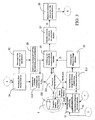
- a vehicle navigation system 1 according to the present invention is schematically shown.
- the vehicle navigation system may be incorporated or associated to a standard vehicle VH or car for providing to the vehicle driver pertinent guiding or driving information corresponding to a track or route that the vehicle driver needs to move along.
- the vehicle navigation system 1 comprises:
- an user can edit, by using the keyboard or similar means of the user interface 7, an ending or final location to be reached and the system 1 shows the route to such an ending location from a starting location, as calculated by the electronic means 2 starting from data obtained by the antenna 3.
- the memory device 5 could be also internal or embedded into the electronic controller 2.
- the electronic controller 2 calculates in real-time a route to be followed by the vehicle VH, starting from an actual position thereof in order to reach the ending location, and provides a driving direction indicator, for instance in the form of an arrow 10.
- the system 1 displays the driving direction indicator or arrow 10 onto the real scene 9 as captured by the digital camera 4 of the vehicle VH, thus forming a real scene based driving information 11.
- the real scene 9 as captured by the digital camera 4, along with the arrow 10 added thereto, i.e. the real scene based driving information 11, may also be projected directly to the windscreen as a perfect head up display.
- the electronic controller 2 executes a series of process or method steps for providing a real scene based driving information 11 according to the present invention which is schematically illustrated in Fig. 3 .
- a vehicle navigation system 1 comprises:
- said camera 4 is a digital camera and said guide advices include at least a directional arrow 10.
- said live picture is stored in digital format inside a portion of said memory 5 is refreshed in said memory portion 5 according to a time schedule of few micro-seconds.
- the software program is endowed with algorithms capable to recognize lanes and lane limits in said digital pictures and to display said at least an arrow 10 within said lane limits. Also road barriers and other obstacles are detected in order to force the system to recalculate the driving advices.
- the software program is further able to process and compare said digital pictures provided by said camera 4 with digital pictures pre-stored in said memory 5 and, in case of discrepancy, replacing said pre-stored digital pictures with said digital pictures provided by said camera.
- the algorithms are capable to recognize road traffic signs and to notify pictorial guide advices 10 according to said road traffic signs.
- a digital camera is used for recording instant and live pictures.
- the method also comprises the steps of:
- the format of the pictures 9 could be, e.g. JPG, MPEG, DIVX, BMP; the pictures being stored in the memory device 5 or in a dedicated RAM memory, not shown since conventional.
- the pictures as taken by the digital camera 4 are processed to detect lane limits (e.g. by the so called "mobile eye” systems).
- the method further comprises the steps of:
- step S3 of calculating a distance D before a next direction change of the vehicle VH will be based on the driving direction indicator 10 as recalculated in step S13.
- improved software analyzing and evaluating means can future assist the driver, allowing to detect road traffic signs like one way road, road not allowed for driving and so on.
- step S12 of updating the Navigation database DB by recording the new structure of the street is not performed, the mismatch between the stored situation and the captured one due to momentarily legally usable roads (for instance, when a road is blocked by changed traffic signaling), a new driving direction indicator 10 is in any case calculated in step S13 and the alternative is displayed to the user to correctly drive him.
- the method further comprises a calibration phase of the digital camera 4, in turn including the following steps:
- Detection can also be done as being based on the yard information; for instance the beacons from distances are given in miles or yards.
- the system for calibration is the same; only the indicators are provided with different value.
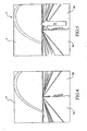
- Figure 4 shows a picture corresponding to a real scene 9 as captured by the digital camera 4
- Figure 5 shows the real scene based driving information 11 as provided by the navigator system according to the present invention onto its display 6, in particular comprising the driving direction indicator 10 in the form of a straight arrow superposed to the real scene 9.
- the displayed real scene based driving information 11 is further improved by correctly positioning the driving direction indicator 10 onto line 9B, along which vehicle has to go.
- step S7 the detected lanes and lane limits in step S7 are used to center the driving direction indicator 10 as calculated by the of the vehicle navigation system 1 inside the picture as taken by the digital camera 4 and correctly show the real scene based driving information 11 on the display 6.
- the invention has the great advantage to suggest the use of a camera installed on the car in addition to the map information coming from a memory unit.
- the camera is easy to install on the car.
- the method provides for combining the information from the map to the detection of the car motion.
- the system will output to a screen the correct direction to be taken so that it is much easier for the driver to understand the correct direction.
Landscapes
- Engineering & Computer Science (AREA)
- Radar, Positioning & Navigation (AREA)
- Remote Sensing (AREA)
- Automation & Control Theory (AREA)
- Physics & Mathematics (AREA)
- General Physics & Mathematics (AREA)
- Theoretical Computer Science (AREA)
- Multimedia (AREA)
- Navigation (AREA)
- Traffic Control Systems (AREA)
Claims (6)
- Fahrzeugnavigationssystem (1), aufweisend:eine Antenne (3), die dafür strukturiert ist, von Satelliten gesendete elektromagnetische Wellen zu empfangen;eine elektronische Steuereinrichtung (2), die dafür konfiguriert ist, ein Softwareprogramm auszuführen, das die globale Position des Fahrzeugs auf der Grundlage der von der Antenne (3) empfangenen elektromagnetischen Wellen detektiert;einen Speicher (5), der mit der elektronischen Steuereinrichtung (2) verbunden ist und eine Navigationsdatenbank (16) umfasst, die elektronische Straßenkarten enthält;eine Anzeigevorrichtung (6), die mit Ausgängen der elektronischen Steuereinrichtung (2) verbunden ist; undeine Kamera (4), die an dem Fahrzeug installiert ist, um auf der Anzeigevorrichtung (6) ein Sofort- und Live-Bild der vom Fahrzeugführer gegenwärtig zu sehenden Landschaftsansicht zu liefern;wobei die Anzeigevorrichtung (6) dazu in der Lage ist, dem Fahrzeugführer entsprechend der genauen Straßenposition des Fahrzeugs, die mit Bezug auf die elektronischen Straßenkarten berechnet wurde, bebilderte Führungsempfehlungen (10) anzuzeigen, die mindestens einen Richtungspfeil umfassen;wobei das Softwareprogramm mit Algorithmen ausgestattet ist, die dazu in der Lage sind, Spuren und Spurenbegrenzungen auf den Livebildern (25) zu erkennen, um wenigstens eine bebilderte Führungsempfehlung (10) innerhalb der Spurbegrenzungen erneut zu berechnen und anzuzeigen,wobei das Fahrzeugnavigationssystem (1) dadurch gekennzeichnet ist, dass das Softwareprogramm dafür konfiguriert ist, ausgehend von dem von der Kamera (4) aufgenommenen Bild die Straßenverkehrszeichen und die zum Fahren verfügbaren Spuren zu analysieren und auszuwerten und auf Grundlage der analysierten und ausgewerteten Straßenverkehrszeichen und zum Fahren verfügbaren Spuren eine Neuberechnung der wenigstens einen bebilderten Führungsempfehlung (10) zu erzwingen, wobei das Softwareprogramm außerdem dazu in der Lage ist, die wenigstens eine neu berechnete bebilderte Führungsempfehlung (10) anzuzeigen.
- System nach Anspruch 1, dadurch gekennzeichnet, dass das Livebild in digitalem Format in einem Bereich des Speichers (5) gespeichert wird.
- System nach Anspruch 2, dadurch gekennzeichnet, dass das Softwareprogramm dazu in der Lage ist, die von der Kamera (4) gelieferten Live-Bilder zu verarbeiten und mit in dem Speicher (5) vorgespeicherten digitalen Bildern zu vergleichen und die vorgespeicherten digitalen Bilder im Fall einer Diskrepanz durch die von der Kamera (4) gelieferten Live-Bilder zu ersetzen.
- System nach Anspruch 1 oder 2, dadurch gekennzeichnet, dass das Livebild als digitales Bild in digitalem Format in einem Bereich des Speichers (5) gespeichert wird.
- Navigationsverfahren zur Unterstützung und Führung eines Fahrzeugführers durch ein Navigationssystem, wobei das Verfahren folgende Schritte beinhaltet:Detektieren einer globalen Position des Fahrzeugs durch eine Antenne (3), die dafür strukturiert ist, von Satelliten gesendete elektromagnetische Wellen zu empfangen, und durch eine elektronische Steuereinrichtung (2) des Navigationssystems; undVergleichen der globalen Position mit in einem Speicher (5) vorgespeicherten Straßenkarten des Systems, um die Straßenposition des Fahrzeugs mit Bezug auf die Straßenkarten zu definieren;Aufzeichnen eines Sofort- und Livebildes der von dem Fahrzeugführer gegenwärtig zu sehenden Landschaftsansicht durch eine in dem Fahrzeug installierte Kamera (4);Anzeigen des Sofort- und Livebildes zusammen mit bebilderten Führungsempfehlungen (10), die wenigstens einen Richtungspfeil umfassen, auf einer Anzeigevorrichtung (6) des Systems für den Fahrzeugführer entsprechend der mit Bezug auf die Straßenkarten berechneten genauen Straßenposition des Fahrzeugs;wobei das Verfahren ferner folgende Schritte beinhaltet, ausgeführt von einem Algorithmus, der in der Steuereinrichtung läuft:- Erkennen von Spuren und Spurenbegrenzungen (12, 13, 14) auf den Livebildern, Neuberechnen und Anzeigen der wenigstens einen bebilderten Führungsempfehlung (10) innerhalb der Spurenbegrenzungen;dadurch gekennzeichnet, dass der in der Steuereinrichtung laufende Algorithmus ferner folgende Schritte ausführt:Analysieren und Auswerten der Straßenverkehrszeichen und der zum Fahren verfügbaren Spuren ausgehend von dem von der Kamera aufgenommenen Bild;- Erzwingen einer Neuberechnung der wenigstens einen bebilderten Führungsempfehlung (10) unter Verwendung der Ergebnisse des Schrittes des Analysierens und Auswertens, und- Anzeigen der wenigstens einen neu berechneten bebilderten Führungsempfehlung (10).
- Verfahren nach Anspruch 5, wobei eine digitale Kamera (4) dazu verwendet wird, Sofort- und Live-Bilder aufzuzeichnen.
Priority Applications (1)
| Application Number | Priority Date | Filing Date | Title |
|---|---|---|---|
| EP10168814.1A EP2241859B1 (de) | 2007-12-31 | 2007-12-31 | Verbessertes Fahrzeugnavigationssystem |
Applications Claiming Priority (2)
| Application Number | Priority Date | Filing Date | Title |
|---|---|---|---|
| EP07025242A EP2075541A1 (de) | 2007-12-31 | 2007-12-31 | Verbessertes Fahrzeugnavigationssystem |
| EP10168814.1A EP2241859B1 (de) | 2007-12-31 | 2007-12-31 | Verbessertes Fahrzeugnavigationssystem |
Related Parent Applications (2)
| Application Number | Title | Priority Date | Filing Date |
|---|---|---|---|
| EP07025242A Division EP2075541A1 (de) | 2007-12-31 | 2007-12-31 | Verbessertes Fahrzeugnavigationssystem |
| EP07025242.4 Division | 2007-12-31 |
Publications (2)
| Publication Number | Publication Date |
|---|---|
| EP2241859A1 EP2241859A1 (de) | 2010-10-20 |
| EP2241859B1 true EP2241859B1 (de) | 2015-04-15 |
Family
ID=39402843
Family Applications (2)
| Application Number | Title | Priority Date | Filing Date |
|---|---|---|---|
| EP07025242A Withdrawn EP2075541A1 (de) | 2007-12-31 | 2007-12-31 | Verbessertes Fahrzeugnavigationssystem |
| EP10168814.1A Active EP2241859B1 (de) | 2007-12-31 | 2007-12-31 | Verbessertes Fahrzeugnavigationssystem |
Family Applications Before (1)
| Application Number | Title | Priority Date | Filing Date |
|---|---|---|---|
| EP07025242A Withdrawn EP2075541A1 (de) | 2007-12-31 | 2007-12-31 | Verbessertes Fahrzeugnavigationssystem |
Country Status (2)
| Country | Link |
|---|---|
| US (1) | US20090171582A1 (de) |
| EP (2) | EP2075541A1 (de) |
Families Citing this family (25)
| Publication number | Priority date | Publication date | Assignee | Title |
|---|---|---|---|---|
| US8374790B2 (en) * | 2009-10-30 | 2013-02-12 | Teejet Technologies Illinois, Llc | Method and apparatus for guiding a vehicle |
| CN102200444B (zh) * | 2010-03-23 | 2013-03-20 | 财团法人资讯工业策进会 | 实时扩增实境装置及其实时扩增实境方法 |
| CN101986101A (zh) * | 2010-09-14 | 2011-03-16 | 浙江天鸿汽车用品有限公司 | Gps实时导航系统 |
| JP5810843B2 (ja) * | 2011-11-02 | 2015-11-11 | アイシン・エィ・ダブリュ株式会社 | レーン案内表示システム、方法およびプログラム |
| JP2013117515A (ja) * | 2011-11-02 | 2013-06-13 | Aisin Aw Co Ltd | レーン案内表示システム、方法およびプログラム |
| CN102706355A (zh) * | 2012-05-18 | 2012-10-03 | 北京腾瑞万里科技有限公司 | 导航方法及移动终端 |
| USD736820S1 (en) * | 2012-11-30 | 2015-08-18 | Google Inc. | Graphical user interface for a display screen or a portion thereof |
| USD731542S1 (en) * | 2012-11-30 | 2015-06-09 | Google Inc. | Portion of a display screen with icon |
| USD732075S1 (en) * | 2012-11-30 | 2015-06-16 | Google Inc. | Portion of a display screen with icon |
| USD741904S1 (en) * | 2012-11-30 | 2015-10-27 | Google Inc. | Display screen or portion thereof with graphical user interface |
| USD735214S1 (en) * | 2012-11-30 | 2015-07-28 | Google Inc. | Display screen or portion thereof with graphical user interface |
| US8676431B1 (en) | 2013-03-12 | 2014-03-18 | Google Inc. | User interface for displaying object-based indications in an autonomous driving system |
| USD750663S1 (en) | 2013-03-12 | 2016-03-01 | Google Inc. | Display screen or a portion thereof with graphical user interface |
| USD754190S1 (en) | 2013-03-13 | 2016-04-19 | Google Inc. | Display screen or portion thereof with graphical user interface |
| USD754189S1 (en) | 2013-03-13 | 2016-04-19 | Google Inc. | Display screen or portion thereof with graphical user interface |
| CN103293543B (zh) * | 2013-06-03 | 2015-05-06 | 安徽富煌和利时科技股份有限公司 | 一种利用gps定位信息自动实现行车区段提示的系统及提示方法 |
| USD760293S1 (en) * | 2013-12-16 | 2016-06-28 | Tencent Technology (Shenzhen) Company Limited | Display screen with graphical user interface |
| USD760287S1 (en) * | 2013-12-16 | 2016-06-28 | Tencent Technology (Shenzhen) Company Limited | Display screen with animated graphical user interface |
| USD757752S1 (en) * | 2014-01-03 | 2016-05-31 | Samsung Electronics Co., Ltd. | Display screen or portion thereof with graphical user interface |
| USD760784S1 (en) * | 2014-01-03 | 2016-07-05 | Samsung Electronics Co., Ltd. | Display screen or portion thereof with icon |
| USD757751S1 (en) * | 2014-05-30 | 2016-05-31 | Microsoft Corporation | Display screen or portion thereof with graphical user interface |
| US10186150B2 (en) * | 2015-07-21 | 2019-01-22 | Nissan Motor Co., Ltd. | Scene determination device, travel assistance apparatus, and scene determination method |
| USD929430S1 (en) * | 2019-01-04 | 2021-08-31 | Byton Limited | Display screen or portion thereof with a graphical user interface |
| USD932504S1 (en) * | 2019-01-04 | 2021-10-05 | Byton Limited | Display screen or portion thereof with a graphical user interface |
| JP2019194739A (ja) * | 2019-08-05 | 2019-11-07 | パイオニア株式会社 | 地図データ記憶装置、制御方法、プログラム及び記憶媒体 |
Citations (1)
| Publication number | Priority date | Publication date | Assignee | Title |
|---|---|---|---|---|
| WO2007129382A1 (ja) * | 2006-04-28 | 2007-11-15 | Panasonic Corporation | ナビゲーション装置およびその方法 |
Family Cites Families (20)
| Publication number | Priority date | Publication date | Assignee | Title |
|---|---|---|---|---|
| KR100224326B1 (ko) * | 1995-12-26 | 1999-10-15 | 모리 하루오 | 차량용 네비게이션장치 |
| JPH09304101A (ja) * | 1996-05-14 | 1997-11-28 | Matsushita Electric Ind Co Ltd | ナビゲーション装置 |
| JPH10132598A (ja) * | 1996-10-31 | 1998-05-22 | Sony Corp | ナビゲート方法、ナビゲーション装置及び自動車 |
| JPH11108684A (ja) * | 1997-08-05 | 1999-04-23 | Harness Syst Tech Res Ltd | カーナビゲーションシステム |
| EP1491857A1 (de) * | 2003-06-26 | 2004-12-29 | Harman Becker Automotive Systems GmbH | Navigationsassistenzverfahren und Navigationssystem |
| JP2005173784A (ja) * | 2003-12-09 | 2005-06-30 | Nec Corp | 映像情報配信システム及び方法と装置並びにプログラム |
| KR20050081492A (ko) * | 2004-02-13 | 2005-08-19 | 디브이에스 코리아 주식회사 | 전방 실제 영상을 사용한 자동차 항법 장치 및 그 제어 방법 |
| US7460953B2 (en) * | 2004-06-30 | 2008-12-02 | Navteq North America, Llc | Method of operating a navigation system using images |
| JP2006078357A (ja) * | 2004-09-10 | 2006-03-23 | Alpine Electronics Inc | ナビゲーション装置およびナビゲーション方法 |
| JP4681856B2 (ja) * | 2004-11-24 | 2011-05-11 | アイシン精機株式会社 | カメラの校正方法及びカメラの校正装置 |
| JP2006162442A (ja) * | 2004-12-07 | 2006-06-22 | Matsushita Electric Ind Co Ltd | ナビゲーション装置及びナビゲーション方法 |
| JP4632793B2 (ja) * | 2005-01-12 | 2011-02-16 | 京セラ株式会社 | ナビゲーション機能付き携帯型端末機 |
| WO2006109527A1 (ja) * | 2005-03-30 | 2006-10-19 | National University Corporation Kumamoto University | ナビゲーション装置およびナビゲーション方法 |
| US20060271286A1 (en) * | 2005-05-27 | 2006-11-30 | Outland Research, Llc | Image-enhanced vehicle navigation systems and methods |
| MX2007015348A (es) * | 2005-06-06 | 2008-02-15 | Tomtom Int Bv | Dispositivo de navegacion con informacion de camara. |
| JP4654823B2 (ja) * | 2005-08-03 | 2011-03-23 | 株式会社デンソー | 道路地図データ更新システム及び道路検出システム |
| JP4921760B2 (ja) * | 2005-09-30 | 2012-04-25 | クラリオン株式会社 | 車載用表示装置、その制御方法及び制御プログラム |
| HUP0500937A2 (en) * | 2005-10-11 | 2007-05-29 | Zoltan Kovacs | Navigation method and equipment mainly for vehicles |
| JP4812415B2 (ja) * | 2005-11-30 | 2011-11-09 | 富士通株式会社 | 地図情報更新システム、中央装置、地図情報更新方法、及びコンピュータプログラム |
| US8352177B2 (en) * | 2006-03-28 | 2013-01-08 | Panasonic Corporation | Navigation apparatus |
-
2007
- 2007-12-31 EP EP07025242A patent/EP2075541A1/de not_active Withdrawn
- 2007-12-31 EP EP10168814.1A patent/EP2241859B1/de active Active
-
2008
- 2008-12-23 US US12/342,568 patent/US20090171582A1/en not_active Abandoned
Patent Citations (2)
| Publication number | Priority date | Publication date | Assignee | Title |
|---|---|---|---|---|
| WO2007129382A1 (ja) * | 2006-04-28 | 2007-11-15 | Panasonic Corporation | ナビゲーション装置およびその方法 |
| EP2015023A1 (de) * | 2006-04-28 | 2009-01-14 | Panasonic Corporation | Navigationseinrichtung und verfahren |
Also Published As
| Publication number | Publication date |
|---|---|
| US20090171582A1 (en) | 2009-07-02 |
| EP2241859A1 (de) | 2010-10-20 |
| EP2075541A1 (de) | 2009-07-01 |
Similar Documents
| Publication | Publication Date | Title |
|---|---|---|
| EP2241859B1 (de) | Verbessertes Fahrzeugnavigationssystem | |
| US8239131B2 (en) | Navigation device, navigation method, and navigation program | |
| EP2195613B1 (de) | Verfahren zur erfassung linearer merkmale entlang einer bezugslinie innerhalb einer fläche zur verwendung in einer kartendatenbank | |
| US8315796B2 (en) | Navigation device | |
| US20090240426A1 (en) | Navigation device and navigation method | |
| US8515664B2 (en) | Digital map signpost system | |
| US8880343B2 (en) | System for digital map labeling | |
| US8232900B2 (en) | Navigation system and route guidance method | |
| US20100121569A1 (en) | Lane determining device, lane determining method and navigation apparatus using the same | |
| KR20050081492A (ko) | 전방 실제 영상을 사용한 자동차 항법 장치 및 그 제어 방법 | |
| CN110926487A (zh) | 辅助驾驶方法、辅助驾驶系统、计算设备及存储介质 | |
| JP2004045227A (ja) | 車両位置測定装置および方法 | |
| JP2008139295A (ja) | カメラを用いた車両用ナビゲーションの交差点案内装置及びその方法 | |
| US20200307576A1 (en) | Driver assistance apparatus and driver assistance method | |
| US20080015775A1 (en) | Road exit modeling using aerial image | |
| CN101629829A (zh) | 用于一导航系统中的图资更新装置及相关导航系统 | |
| JP2011047649A (ja) | ナビゲーション装置 | |
| JP2004257979A (ja) | ナビゲーション装置 | |
| EP2088571A2 (de) | System, Verfahren und Programm zur Fahrassistenz | |
| JP2007274564A (ja) | キャリブレーション装置及びキャリブレーション方法 | |
| US20130066549A1 (en) | Navigation device and method | |
| CN108242163B (zh) | 驾驶员辅助系统、机动车、输出交通信息的方法和介质 | |
| US9638540B2 (en) | Device and method for displaying a map according to the guiding of a navigation system | |
| KR20080019690A (ko) | 카메라 정보를 구비하는 내비게이션 기기 | |
| JP2016161483A (ja) | 情報提供装置、及び情報提供プログラム |
Legal Events
| Date | Code | Title | Description |
|---|---|---|---|
| PUAI | Public reference made under article 153(3) epc to a published international application that has entered the european phase |
Free format text: ORIGINAL CODE: 0009012 |
|
| AC | Divisional application: reference to earlier application |
Ref document number: 2075541 Country of ref document: EP Kind code of ref document: P |
|
| AK | Designated contracting states |
Kind code of ref document: A1 Designated state(s): DE FR GB IT |
|
| 17P | Request for examination filed |
Effective date: 20110420 |
|
| 17Q | First examination report despatched |
Effective date: 20110627 |
|
| GRAP | Despatch of communication of intention to grant a patent |
Free format text: ORIGINAL CODE: EPIDOSNIGR1 |
|
| INTG | Intention to grant announced |
Effective date: 20140619 |
|
| RAP1 | Party data changed (applicant data changed or rights of an application transferred) |
Owner name: STMICROELECTRONICS GMBH Owner name: STMICROELECTRONICS DESIGN AND APPLICATION GMBH |
|
| GRAS | Grant fee paid |
Free format text: ORIGINAL CODE: EPIDOSNIGR3 |
|
| RAP1 | Party data changed (applicant data changed or rights of an application transferred) |
Owner name: STMICROELECTRONICS GMBH Owner name: STMICROELECTRONICS APPLICATION GMBH |
|
| GRAP | Despatch of communication of intention to grant a patent |
Free format text: ORIGINAL CODE: EPIDOSNIGR1 |
|
| INTG | Intention to grant announced |
Effective date: 20150120 |
|
| GRAA | (expected) grant |
Free format text: ORIGINAL CODE: 0009210 |
|
| AC | Divisional application: reference to earlier application |
Ref document number: 2075541 Country of ref document: EP Kind code of ref document: P |
|
| AK | Designated contracting states |
Kind code of ref document: B1 Designated state(s): DE FR GB IT |
|
| REG | Reference to a national code |
Ref country code: GB Ref legal event code: FG4D |
|
| REG | Reference to a national code |
Ref country code: DE Ref legal event code: R096 Ref document number: 602007041112 Country of ref document: DE Effective date: 20150528 |
|
| REG | Reference to a national code |
Ref country code: FR Ref legal event code: PLFP Year of fee payment: 9 |
|
| REG | Reference to a national code |
Ref country code: DE Ref legal event code: R097 Ref document number: 602007041112 Country of ref document: DE |
|
| PLBE | No opposition filed within time limit |
Free format text: ORIGINAL CODE: 0009261 |
|
| STAA | Information on the status of an ep patent application or granted ep patent |
Free format text: STATUS: NO OPPOSITION FILED WITHIN TIME LIMIT |
|
| 26N | No opposition filed |
Effective date: 20160118 |
|
| PG25 | Lapsed in a contracting state [announced via postgrant information from national office to epo] |
Ref country code: IT Free format text: LAPSE BECAUSE OF FAILURE TO SUBMIT A TRANSLATION OF THE DESCRIPTION OR TO PAY THE FEE WITHIN THE PRESCRIBED TIME-LIMIT Effective date: 20150415 |
|
| GBPC | Gb: european patent ceased through non-payment of renewal fee |
Effective date: 20151231 |
|
| PG25 | Lapsed in a contracting state [announced via postgrant information from national office to epo] |
Ref country code: GB Free format text: LAPSE BECAUSE OF NON-PAYMENT OF DUE FEES Effective date: 20151231 |
|
| REG | Reference to a national code |
Ref country code: FR Ref legal event code: PLFP Year of fee payment: 10 |
|
| REG | Reference to a national code |
Ref country code: FR Ref legal event code: PLFP Year of fee payment: 11 |
|
| PGFP | Annual fee paid to national office [announced via postgrant information from national office to epo] |
Ref country code: FR Payment date: 20231122 Year of fee payment: 17 Ref country code: DE Payment date: 20231121 Year of fee payment: 17 |