EP2138804A2 - Verfahren und Vorrichtung zur Anzeige einer Karte auf Basis einer Kursrichtung - Google Patents
Verfahren und Vorrichtung zur Anzeige einer Karte auf Basis einer Kursrichtung Download PDFInfo
- Publication number
- EP2138804A2 EP2138804A2 EP20090156271 EP09156271A EP2138804A2 EP 2138804 A2 EP2138804 A2 EP 2138804A2 EP 20090156271 EP20090156271 EP 20090156271 EP 09156271 A EP09156271 A EP 09156271A EP 2138804 A2 EP2138804 A2 EP 2138804A2
- Authority
- EP
- European Patent Office
- Prior art keywords
- centre
- course
- current position
- map
- area
- Prior art date
- Legal status (The legal status is an assumption and is not a legal conclusion. Google has not performed a legal analysis and makes no representation as to the accuracy of the status listed.)
- Granted
Links
Images



Classifications
-
- G—PHYSICS
- G01—MEASURING; TESTING
- G01C—MEASURING DISTANCES, LEVELS OR BEARINGS; SURVEYING; NAVIGATION; GYROSCOPIC INSTRUMENTS; PHOTOGRAMMETRY OR VIDEOGRAMMETRY
- G01C21/00—Navigation; Navigational instruments not provided for in groups G01C1/00 - G01C19/00
- G01C21/26—Navigation; Navigational instruments not provided for in groups G01C1/00 - G01C19/00 specially adapted for navigation in a road network
- G01C21/34—Route searching; Route guidance
- G01C21/36—Input/output arrangements for on-board computers
- G01C21/3667—Display of a road map
- G01C21/367—Details, e.g. road map scale, orientation, zooming, illumination, level of detail, scrolling of road map or positioning of current position marker
-
- G—PHYSICS
- G08—SIGNALLING
- G08G—TRAFFIC CONTROL SYSTEMS
- G08G1/00—Traffic control systems for road vehicles
- G08G1/09—Arrangements for giving variable traffic instructions
- G08G1/0962—Arrangements for giving variable traffic instructions having an indicator mounted inside the vehicle, e.g. giving voice messages
- G08G1/0968—Systems involving transmission of navigation instructions to the vehicle
- G08G1/0969—Systems involving transmission of navigation instructions to the vehicle having a display in the form of a map
-
- G—PHYSICS
- G09—EDUCATION; CRYPTOGRAPHY; DISPLAY; ADVERTISING; SEALS
- G09B—EDUCATIONAL OR DEMONSTRATION APPLIANCES; APPLIANCES FOR TEACHING, OR COMMUNICATING WITH, THE BLIND, DEAF OR MUTE; MODELS; PLANETARIA; GLOBES; MAPS; DIAGRAMS
- G09B29/00—Maps; Plans; Charts; Diagrams, e.g. route diagram
- G09B29/003—Maps
- G09B29/005—Map projections or methods associated specifically therewith
-
- G—PHYSICS
- G09—EDUCATION; CRYPTOGRAPHY; DISPLAY; ADVERTISING; SEALS
- G09B—EDUCATIONAL OR DEMONSTRATION APPLIANCES; APPLIANCES FOR TEACHING, OR COMMUNICATING WITH, THE BLIND, DEAF OR MUTE; MODELS; PLANETARIA; GLOBES; MAPS; DIAGRAMS
- G09B29/00—Maps; Plans; Charts; Diagrams, e.g. route diagram
- G09B29/10—Map spot or coordinate position indicators; Map reading aids
- G09B29/106—Map spot or coordinate position indicators; Map reading aids using electronic means
Definitions
- the present invention relates to a map displaying apparatus and method, and more particularly, to a map displaying apparatus and method by which an area in a course direction is more widely displayed on a screen.
- a navigation system calculates a position of a local navigation terminal based on signals received from a plurality of global positioning system (GPS) satellites and displays a current position and a course to a destination of the navigation terminal on a screen.
- GPS global positioning system
- the navigation terminals are more widely used in cars that frequently search for a course.
- the information has to be appropriately displayed on a screen of the navigation terminal.
- map displaying methods include a head-up mode method in which a map is displayed so that a current movement direction of a driver always corresponds to an upward direction of a screen.
- a north-up mode method in which a map is displayed so that an actual north direction always corresponds to an upward direction of a screen.
- a further example is a bird's-eye view mode method in which a map is three-dimensionally displayed so that a driver can easily compare an actual driving environment to the map displayed on a screen.
- map displaying methods do not display a certain area of the map that the driver may want to see on a screen.
- aspects of the present invention provide a map displaying apparatus and method thereof whereby an area or more interest to a user is displayed on a screen, and a computer readable recording medium having recorded thereon a computer program for executing the map displaying method.
- a map displaying method to display a map on a screen, the map displaying method including: determining a course direction of an object at a current position of the map; moving a first centre of a first area of the map is set based on the current position, by a predetermined distance in the course direction so as to determine a second centre; and displaying a second area of the map on the screen having the second centre as a centre thereof.
- the determining of the course direction may include setting an analysis area to analyze the course direction at the current position; and analyzing a course included in the analysis area and determining a direction of the course included in the analysis area as the course direction.
- the direction of the course included in the analysis area may be a direction of the course from the current position or the first centre to a predetermined destination.
- the determining of the direction of the course included in the analysis area may include determining a point where a course from the current position or the first centre to the predetermined destination intersects a boundary of the analysis area; and determining a direction from the current position or the first centre to the point on the boundary of the analysis area as the course direction.
- the course direction at the current position may be a link direction at the current position.
- the moving of the first centre may include moving the first centre by a predetermined distance in only a vertical or a horizontal direction based on the course direction so as to determine the second centre.
- a map displaying apparatus to display a map on a screen, the apparatus including: a course direction determination unit to determine a course direction at a current position of a map; a centre movement unit to move a first centre of a first area that is set based on the current position, by a predetermined distance in the course direction so as to determine a second centre; and a display unit to display a second area having the second centre as a centre thereof.
- a computer readable recording medium having recorded thereon a computer program for executing the map displaying method.
- a map displaying method to display a map on a screen, the map displaying method including: displaying a first area of the map on the screen, the first area having a first centre; determining a course direction of an object at a current position of the map; and displaying a second area of the map on the screen, the second area having a second centre as a centre thereof, wherein the second centre is a predetermined distance away, in the course direction, from the first centre.
- a map displaying apparatus to display a map on a screen
- the map displaying apparatus including: a course direction determination unit to determine a course direction of an object at a current position of the map; and a display unit to change a display of a first area of the map on the screen, the first area having a first centre, to a second area of the map on the screen, the second area having a second centre as a centre thereof, wherein the second centre is a predetermined distance away, in the course direction, from the first centre.
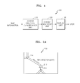
- FIG. 1 is a block diagram of a map displaying apparatus 100 according to an embodiment of the present invention.
- the map displaying apparatus 100 includes a course direction determination unit 110, a centre movement unit 120, and a display unit 130. While not restricted thereto, the apparatus 100 can be included in a car, a telephone, a personal media player, a portable computer, or as a stand alone GPS unit. Further, while not shown, it is understood that the apparatus 100 can include a GPS device to determine the location and a storage device to store the map information.
- the course direction determination unit 110 determines a course direction at a current position in a first area that is set based on the current position. Accordingly, a user seeing a map displayed on a screen (such as the display unit 130) of a mobile device (such as a navigation terminal) can view information on an area that the user is going to move to, rather than information on an area that the user is moving from. Such information can include information on road conditions and points of interest (POIs) of the area that the user is going to move to. The area that the user is going to move to is determined in accordance with the course direction at the current position determined by the course direction determination unit 110. The course direction at the current position may be determined by any of a variety of methods.
- a link direction at the current position or a direction of a course, that is included in a predetermined analysis area, from the current position to a destination may be determined as the course direction at the current position.
- a method of determining a course direction will now be described in detail with reference to FIGs. 2A through 2C .
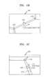
- FIGs. 2A through 2C are diagrams to describe a method of determining a course direction, according to an embodiment of the present invention.
- the method illustrated in FIGs. 2A through 2C determines a link direction at a current position as the course direction.
- a link is a single course, or route, between two nodes and, thus, the link direction is a movement direction of a user.
- FIG. 2A illustrates a head-up mode.
- the head-up mode displays a map so that the movement direction of the user always corresponds to an upward direction of a first area 200 on a screen that is set based on the current position. If a link from a node A 212 to a node B 214 is as illustrated in FIG. 2A , a link direction 216 is determined as the course direction at the current position.
- the first area 200 is an area displayed on the screen when the map is displayed, regardless of the movement direction of the user (i.e., the course direction at the current position).
- the current position is displayed on a vertical line that intersects the screen on which the map is displayed, and the first area 200 is set based on the current position.
- FIG. 2B illustrates a north-up mode.
- the north-up mode displays the map so that an actual north direction always corresponds to the upward direction of the first area 200 on the screen. If a link from a node A 222 to a node B 224 is as illustrated in FIG. 2B , a link direction 226 is determined as the course direction at the current position.
- FIG. 2C illustrates a bird's-eye view mode.
- the bird's-eye view mode three-dimensionally displays the map. If a link from a node A 232 to a node B 234 is as illustrated in FIG. 2C , a link direction 236 is determined as the course direction at the current position.
- FIGs. 2A through 2C show cases when a link direction at a current position is determined as a course direction. However, if a course from the current position to a destination is detected, a direction of the detected course may be determined as the course direction at the current position. A method of determining a course direction when a course from a current position to a destination is detected will now be described in detail with reference to FIGs. 3A through 3C .
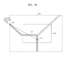
- FIGs. 3A through 3C are diagrams to describe a method of determining a course direction, according to another embodiment of the present invention.
- a course 312 (represented as a shaded portion), also referred to herein as a route, from a current position 310 to a destination is detected in a first area 300.
- the course direction determination unit 110 illustrated in FIG. 1 sets the analysis area 320 in order to analyse the course direction at the current position 310.
- a large area including the first area 300 that is set based on the current position 310 is set as the analysis area 320.
- the same area as the first area 300 or a smaller area included in the first area 300 may also be set as the analysis area 320 according to other aspects.
- the course direction determination unit 110 sets a direction 326 from a centre 322 of the first area 300 to a point 324 where the detected course 312 intersects a boundary of the analysis area 320, as the course direction 326.
- a direction 328 from the current position 310 (as opposed to the centre 322 of the first area 300 as shown in FIG. 3B ) to the point 324 where the detected course 312 meets the boundary of the analysis area 320, may be determined as the course direction 326. Accordingly, if the centre 322 of the first area 300 differs from the current position 310, the direction 326 illustrated in FIG. 3B differs from the direction 328 illustrated in FIG. 3C .
- FIGs. 3A through 3C are described based on a head-up mode, it is understood that the same method may be applied to a north-up mode or a bird's-eye view mode shown in FIGs. 2B and 2C .
- the centre movement unit 120 moves a first centre of the first area to a second centre in accordance with the course direction at the current position, determined by the course direction determination unit 110.
- the display unit 130 displays a second area having the second centre on a screen.
- the first area displayed on the screen moves to the second area.
- a method of moving an area displayed on a screen will now be described in detail with reference to FIGs. 4A through 4C .
- FIGs. 4A through 4C are diagrams to describe methods of moving an area displayed on a screen, according to embodiments of the present invention.
- FIG. 4A illustrates a method of moving an area displayed on a screen when a course direction at a current position 220 is determined as illustrated in FIG. 2B .
- the centre movement unit 120 moves a first centre 402 of a first area 200 that is set based on the current position 220, in a link direction 226 that is determined by the course direction determination unit 110, so as to determine a second centre 404.
- a movement distance from the first centre 402 to the second centre 404 may differ in accordance with embodiments of the present invention.
- the movement distance can vary as long as the current position 220 can be displayed on the screen.
- the movement distance may adaptively differ in accordance with a user's speed of movement, which will be described in detail later with reference to FIG. 5 .
- the display unit 130 displays a second area 400 having the second centre 404 as its centre, on the screen.
- FIG. 4A is described based on a north-up mode, it is understood that the same method may be applied to a head-up mode or a bird's-eye view mode.
- FIG. 4B illustrates a method of moving an area displayed on a screen when a course direction at a current position 310 is determined as illustrated in FIG. 3B .
- the centre movement unit 120 moves a first centre 322 of a first area 300 that is set based on the current position 310, in a direction 326 that is determined as the course direction in FIG. 3B , so as to determine a second centre 412.
- a movement distance from the first centre 322 to the second centre 412 can vary, according to aspects of the present invention, as long as the current position 310 can be displayed on the screen.
- FIG. 4B is described based on the direction 326 illustrated in FIG. 3B , the same method may be applied when the direction 328 illustrated in FIG.
- 3C is determined as the course direction.
- the first centre 322 of the first area 300 may move by a predetermined distance in the direction 328 illustrated in FIG. 3C instead of the direction 326 illustrated in FIG. 3B , so as to determine a different second centre.
- the display unit 130 displays a second area 410 having the second centre 412 as its centre, on the screen.
- FIG. 4B is described based on a head-up mode, it is understood that the same method may be applied to a north-up mode or a bird's-eye view mode.
- FIG. 4C illustrates a method of moving an area displayed on a screen, according to another embodiment of the present invention.
- the centre movement unit 120 moves a first centre 322 of a first area 300 in only a vertical or a horizontal direction based on a course direction at a current position 310.
- the centre movement unit 120 moves the first centre 322 in only the horizontal direction so as to determine a second centre 422.
- the first centre 322 respectively moves in the vertical or the horizontal direction.
- the course direction is a top-left direction as illustrated in FIG. 3B or FIG. 3C
- the first centre 322 does not move in a top-left direction in the current embodiment.
- the first centre 322 moves in only the vertical or the horizontal direction so as to determine the second centre 422.
- the method illustrated in FIG. 4C may be applied to a head-up mode, a north-up mode, or a bird's-eye view mode.
- the first centre 322 may move based on only a horizontal component of the course direction, so as to determine the second centre 422, in the head-up mode or the bird's-eye view mode.
- FIG. 5 is a diagram to describe a method of moving an area displayed on a screen in accordance with a speed of movement, according to an embodiment of the present invention.
- a movement distance of a first centre 510 may differ in accordance with a user's speed of movement. If the user's speed of movement is relatively high (for example, greater than a predetermined speed), the first centre 510 moves to a second centre 520 so that the user can view information on an area that is relatively farther from the current position in a movement direction. As illustrated, a distance between the first centre 510 and the second centre 520 is relatively large. Accordingly, a displacement between a first area 500 having the first centre 510 as its centre and a second area 502 to be displayed on the screen is also respectively large.
- the first centre 510 moves to a second centre 530 so that the user can view information on an area that is relatively closer to the current position in the movement direction.
- a distance between the first centre 510 and the second centre 530 is relatively small. Accordingly, a displacement between the first area 500 having the first centre 510 as its centre and a second area 504 to be displayed on the screen is smaller than the case when the user's speed of movement is high.
- FIG. 6 is a flowchart of a map displaying method according to an embodiment of the present invention.
- a map display apparatus determines a course direction at a current position in operation 610.
- a link direction at the current position or a direction of a course, that is included in a predetermined analysis area, from the current position to a destination is determined as the course direction, though it is understood that aspects of the present invention are not limited thereto.
- the map display apparatus moves a first centre of a first area that is set based on the current position by a predetermined distance in the course direction that is determined in operation 610, so as to determine a second centre in operation 620.
- the first area is set regardless of the course direction at the current position and is an area displayed on a screen when a map is displayed in a display mode (such as a head-up mode, a north-up mode, or a bird's-eye view mode).
- the map display apparatus displays a second area having the second centre that is determined in operation 620, as its centre on the screen in operation 630.
- the second area is set based on the second centre that is moved from the first centre of the first area, and is displayed on the screen. Since the second centre is determined based on the course direction at the current position, the second area is moved from the first area by the predetermined distance in the course direction.
- FIG. 7 is a flowchart of a method of calling a centre movement operation, according to an embodiment of the present invention.
- a method of applying a map displaying operation is illustrated, in which an area that is moved from a first area by a predetermined distance based on a course direction at a current position is displayed on a screen as described above with reference to FIGs. 1, 2A through 2C , 3A through 3C , 4A through 5C , 5, and 6 .
- a map display apparatus calls the centre movement operation in operation 710. Then, the map display apparatus determines whether a course from a current position to a destination is detected in operation 720. Different methods of determining a course direction at the current position can be used according to whether the course from the current position to the destination is detected.
- an analysis area is set in order to analyze the course in operation 730.
- the map display apparatus determines the course direction in the analysis area in operation 750. For example, a point where the detected course intersects a boundary of the analysis area is determined and a direction from the current position or a first centre of the first area to the determined point may be determined as the course direction.
- a method of determining a course direction is not limited to the method described above with reference to FIGs. 3A through 3C .
- the map display apparatus determines a link direction as the course direction in operation 740.
- a link is a single course between two nodes and thus the link direction is a movement direction of a user on the link. Accordingly, the link direction is determined as the course direction.
- the map display apparatus moves the first centre of the first area in the determined course direction (operation 740 or 750), so as to determine a second centre in operation 760.
- Operation 760 corresponds to operation 620 illustrated in FIG. 6 .
- the map display apparatus displays a second area having the second centre as its centre, on the screen, in operation 770.
- the centre movement operation may be selectively used.
- the map display apparatus may or may not use the centre movement operation in accordance with a user's input.
- the centre movement operation may not be used and the first area that is set based on the current position may be displayed on the screen.
- the centre movement operation may not be used if the user departs from the course by more than a predetermined distance.
- the centre movement operation may be re-called.
- an area in a course direction may be more widely displayed on a screen and, thus, a user may rapidly check information on an area that the user is going to. Accordingly, a driver may safely drive a car by easily predicting a course.
- aspects of the present invention can also be embodied as computer-readable codes on a computer-readable recording medium.
- the computer-readable recording medium is any data storage device that can store data that can be thereafter read by a computer system. Examples of the computer-readable recording medium include read-only memory (ROM), random-access memory (RAM), CD-ROMs, magnetic tapes, floppy disks, and optical data storage devices.
- ROM read-only memory
- RAM random-access memory
- CD-ROMs compact discs, digital versatile discs, and Blu-rays, and Blu-rays, and Blu-rays, etc.
- the computer-readable recording medium can also be distributed over network-coupled computer systems so that the computer-readable code is stored and executed in a distributed fashion.
Landscapes
- Engineering & Computer Science (AREA)
- Physics & Mathematics (AREA)
- Theoretical Computer Science (AREA)
- Remote Sensing (AREA)
- General Physics & Mathematics (AREA)
- Radar, Positioning & Navigation (AREA)
- Business, Economics & Management (AREA)
- Educational Administration (AREA)
- Educational Technology (AREA)
- Mathematical Physics (AREA)
- Automation & Control Theory (AREA)
- Navigation (AREA)
- Instructional Devices (AREA)
Applications Claiming Priority (1)
| Application Number | Priority Date | Filing Date | Title |
|---|---|---|---|
| KR1020080060229A KR101538653B1 (ko) | 2008-06-25 | 2008-06-25 | 경로 방향에 기초한 맵 표시 방법 및 장치 |
Publications (3)
| Publication Number | Publication Date |
|---|---|
| EP2138804A2 true EP2138804A2 (de) | 2009-12-30 |
| EP2138804A3 EP2138804A3 (de) | 2012-11-14 |
| EP2138804B1 EP2138804B1 (de) | 2015-09-23 |
Family
ID=41055451
Family Applications (1)
| Application Number | Title | Priority Date | Filing Date |
|---|---|---|---|
| EP09156271.0A Not-in-force EP2138804B1 (de) | 2008-06-25 | 2009-03-26 | Verfahren und Vorrichtung zur Anzeige einer Karte auf Basis einer Kursrichtung |
Country Status (4)
| Country | Link |
|---|---|
| US (1) | US20090326812A1 (de) |
| EP (1) | EP2138804B1 (de) |
| KR (1) | KR101538653B1 (de) |
| ES (1) | ES2551357T3 (de) |
Cited By (1)
| Publication number | Priority date | Publication date | Assignee | Title |
|---|---|---|---|---|
| CN109377856A (zh) * | 2018-10-31 | 2019-02-22 | 巴中彩颉电子商务有限公司 | 一种区域性定制地图制作方法 |
Families Citing this family (1)
| Publication number | Priority date | Publication date | Assignee | Title |
|---|---|---|---|---|
| US9031783B2 (en) * | 2013-02-28 | 2015-05-12 | Blackberry Limited | Repositionable graphical current location indicator |
Citations (2)
| Publication number | Priority date | Publication date | Assignee | Title |
|---|---|---|---|---|
| JPH06331367A (ja) | 1993-05-19 | 1994-12-02 | Sumitomo Electric Ind Ltd | 道路地図表示装置 |
| EP1014038A1 (de) | 1997-06-20 | 2000-06-28 | Mitsubishi Denki Kabushiki Kaisha | Karteninformationsanzeigevorrichtung |
Family Cites Families (19)
| Publication number | Priority date | Publication date | Assignee | Title |
|---|---|---|---|---|
| US5093669A (en) * | 1989-10-20 | 1992-03-03 | Mazda Motor Corporation | Vehicle navigation apparatus |
| US5412573A (en) * | 1993-05-20 | 1995-05-02 | Motorola Inc. | Multi-mode route guidance system and method therefor |
| US5982301A (en) * | 1995-01-20 | 1999-11-09 | Mitsubishi Denki Kabushiki Kaisha | Navigation apparatus |
| US6138203A (en) * | 1995-11-10 | 2000-10-24 | Sony Corporation | Information processing apparatus and method enabling a write-once recording medium to be utilized as a rewriteable recording medium |
| JP3630258B2 (ja) * | 1997-02-10 | 2005-03-16 | 本田技研工業株式会社 | 経路誘導装置 |
| US6160778A (en) * | 1999-03-08 | 2000-12-12 | Matsushita Electric Industrial Co., Ltd. | Information recording medium, information recording method, information recording apparatus and information reproducing apparatus |
| EP1335339B1 (de) * | 2002-01-30 | 2005-10-05 | Pioneer Corporation | Ortsanzeigesystem |
| EP1416252A2 (de) * | 2002-11-01 | 2004-05-06 | Matsushita Electric Industrial Co., Ltd. | Anzeige der empfohlenen Route in einer Navigationsvorrichtung |
| KR101008641B1 (ko) * | 2002-12-11 | 2011-01-17 | 엘지전자 주식회사 | 1회 기록가능한 광디스크에 있어서의 중첩기록 관리방법 및장치 |
| US6839628B1 (en) * | 2003-06-13 | 2005-01-04 | Alpine Electronics, Inc | Display method and apparatus for arranging order of listing points of interest for navigation system |
| JP2005017052A (ja) * | 2003-06-25 | 2005-01-20 | Hitachi Ltd | ナビゲーションの表示方法 |
| JP3962764B2 (ja) * | 2004-06-11 | 2007-08-22 | 松下電器産業株式会社 | 地図表示装置及び地図表示方法 |
| KR100663025B1 (ko) * | 2004-07-20 | 2006-12-28 | 엘지전자 주식회사 | 네비게이션 시스템의 배경지도 업데이트 방법 |
| JP4783603B2 (ja) * | 2005-08-26 | 2011-09-28 | 株式会社デンソー | 地図表示装置、地図表示方法、地図表示プログラム、及びそのプログラムを記録した記録媒体 |
| WO2007066483A1 (ja) * | 2005-12-07 | 2007-06-14 | Matsushita Electric Industrial Co., Ltd. | 経路情報表示装置および経路情報表示方法 |
| JP4595866B2 (ja) * | 2006-03-30 | 2010-12-08 | アイシン・エィ・ダブリュ株式会社 | 経路情報作成システム及び経路情報作成方法 |
| JP4654968B2 (ja) * | 2006-04-25 | 2011-03-23 | 株式会社デンソー | ナビゲーション装置 |
| TWI291548B (en) * | 2006-10-13 | 2007-12-21 | Mitac Int Corp | Navigation device capable of displaying on the basis of moving direction and the method thereof |
| US8073617B2 (en) * | 2006-12-27 | 2011-12-06 | Aisin Aw Co., Ltd. | Map information generating systems, methods, and programs |
-
2008
- 2008-06-25 KR KR1020080060229A patent/KR101538653B1/ko active Active
- 2008-12-03 US US12/327,269 patent/US20090326812A1/en not_active Abandoned
-
2009
- 2009-03-26 EP EP09156271.0A patent/EP2138804B1/de not_active Not-in-force
- 2009-03-26 ES ES09156271.0T patent/ES2551357T3/es active Active
Patent Citations (2)
| Publication number | Priority date | Publication date | Assignee | Title |
|---|---|---|---|---|
| JPH06331367A (ja) | 1993-05-19 | 1994-12-02 | Sumitomo Electric Ind Ltd | 道路地図表示装置 |
| EP1014038A1 (de) | 1997-06-20 | 2000-06-28 | Mitsubishi Denki Kabushiki Kaisha | Karteninformationsanzeigevorrichtung |
Cited By (1)
| Publication number | Priority date | Publication date | Assignee | Title |
|---|---|---|---|---|
| CN109377856A (zh) * | 2018-10-31 | 2019-02-22 | 巴中彩颉电子商务有限公司 | 一种区域性定制地图制作方法 |
Also Published As
| Publication number | Publication date |
|---|---|
| KR20100000651A (ko) | 2010-01-06 |
| EP2138804B1 (de) | 2015-09-23 |
| ES2551357T3 (es) | 2015-11-18 |
| US20090326812A1 (en) | 2009-12-31 |
| EP2138804A3 (de) | 2012-11-14 |
| KR101538653B1 (ko) | 2015-07-29 |
Similar Documents
| Publication | Publication Date | Title |
|---|---|---|
| US9691281B2 (en) | Navigation system with image assisted navigation mechanism and method of operation thereof | |
| US7519469B2 (en) | Display method and apparatus for navigation system | |
| KR100429128B1 (ko) | 네비게이션 장치 | |
| US7590487B2 (en) | Method and apparatus of displaying three-dimensional arrival screen for navigation system | |
| US20100268460A1 (en) | Navigation system with predictive multi-routing and method of operation thereof | |
| EP2096413A1 (de) | Verfahren und Vorrichtungen zur Entfernungseinstellung für die Erzeugung von Manövrieranleitungen für Navigationssysteme | |
| EP2302323A2 (de) | Verfahren, System und Computerprogrammprodukt zum Navigieren eines Fahrzeugs | |
| JP4783603B2 (ja) | 地図表示装置、地図表示方法、地図表示プログラム、及びそのプログラムを記録した記録媒体 | |
| EP2136185A2 (de) | Verfahren und Vorrichtung zur Anzeige einer Karte unter Verwendung nichtlinearer Kompression | |
| JP2001174271A (ja) | ナビゲーション装置 | |
| CN104598712A (zh) | 定位点筛选方法及其系统 | |
| US9304013B2 (en) | Storage device and navigation system | |
| EP2988097A1 (de) | Fahrunterstützungssystem, -verfahren und programm | |
| JP5183353B2 (ja) | ナビゲーション装置 | |
| EP2138804B1 (de) | Verfahren und Vorrichtung zur Anzeige einer Karte auf Basis einer Kursrichtung | |
| JP4111444B2 (ja) | ナビゲーション装置 | |
| JP4097553B2 (ja) | ナビゲーション装置 | |
| JP2005321268A (ja) | ナビゲーション装置 | |
| JP4682210B2 (ja) | ナビゲーション装置、処理制御方法、処理制御プログラム、および記録媒体 | |
| US8340906B2 (en) | Method for generating and searching through trajectory content performed in navigation device | |
| JP3909185B2 (ja) | 車載用電子機器 | |
| JP2008082818A (ja) | ナビゲーションシステムおよびナビゲーション装置 | |
| KR20260041775A (ko) | 내비게이션 서비스 제공 방법 및 시스템 | |
| JP2007040795A (ja) | ナビゲーション装置及び情報提供方法 | |
| CN110892229A (zh) | 通知控制装置及通知控制方法 |
Legal Events
| Date | Code | Title | Description |
|---|---|---|---|
| PUAI | Public reference made under article 153(3) epc to a published international application that has entered the european phase |
Free format text: ORIGINAL CODE: 0009012 |
|
| AK | Designated contracting states |
Kind code of ref document: A2 Designated state(s): AT BE BG CH CY CZ DE DK EE ES FI FR GB GR HR HU IE IS IT LI LT LU LV MC MK MT NL NO PL PT RO SE SI SK TR |
|
| AX | Request for extension of the european patent |
Extension state: AL BA RS |
|
| RAP1 | Party data changed (applicant data changed or rights of an application transferred) |
Owner name: SAMSUNG ELECTRONICS CO., LTD. |
|
| PUAL | Search report despatched |
Free format text: ORIGINAL CODE: 0009013 |
|
| AK | Designated contracting states |
Kind code of ref document: A3 Designated state(s): AT BE BG CH CY CZ DE DK EE ES FI FR GB GR HR HU IE IS IT LI LT LU LV MC MK MT NL NO PL PT RO SE SI SK TR |
|
| AX | Request for extension of the european patent |
Extension state: AL BA RS |
|
| RIC1 | Information provided on ipc code assigned before grant |
Ipc: G09B 29/10 20060101ALI20121010BHEP Ipc: G01C 21/36 20060101AFI20121010BHEP Ipc: G08G 1/0969 20060101ALI20121010BHEP |
|
| 17P | Request for examination filed |
Effective date: 20130514 |
|
| AKX | Designation fees paid |
Designated state(s): CH ES FI LI PL SE TR |
|
| REG | Reference to a national code |
Ref country code: DE Ref legal event code: R108 |
|
| REG | Reference to a national code |
Ref country code: DE Ref legal event code: R108 Effective date: 20130717 |
|
| 17Q | First examination report despatched |
Effective date: 20130909 |
|
| GRAP | Despatch of communication of intention to grant a patent |
Free format text: ORIGINAL CODE: EPIDOSNIGR1 |
|
| INTG | Intention to grant announced |
Effective date: 20150429 |
|
| GRAS | Grant fee paid |
Free format text: ORIGINAL CODE: EPIDOSNIGR3 |
|
| GRAA | (expected) grant |
Free format text: ORIGINAL CODE: 0009210 |
|
| AK | Designated contracting states |
Kind code of ref document: B1 Designated state(s): CH ES FI LI PL SE TR |
|
| REG | Reference to a national code |
Ref country code: CH Ref legal event code: EP |
|
| REG | Reference to a national code |
Ref country code: ES Ref legal event code: FG2A Ref document number: 2551357 Country of ref document: ES Kind code of ref document: T3 Effective date: 20151118 |
|
| PG25 | Lapsed in a contracting state [announced via postgrant information from national office to epo] |
Ref country code: FI Free format text: LAPSE BECAUSE OF FAILURE TO SUBMIT A TRANSLATION OF THE DESCRIPTION OR TO PAY THE FEE WITHIN THE PRESCRIBED TIME-LIMIT Effective date: 20150923 |
|
| PG25 | Lapsed in a contracting state [announced via postgrant information from national office to epo] |
Ref country code: SE Free format text: LAPSE BECAUSE OF FAILURE TO SUBMIT A TRANSLATION OF THE DESCRIPTION OR TO PAY THE FEE WITHIN THE PRESCRIBED TIME-LIMIT Effective date: 20150923 |
|
| PG25 | Lapsed in a contracting state [announced via postgrant information from national office to epo] |
Ref country code: PL Free format text: LAPSE BECAUSE OF FAILURE TO SUBMIT A TRANSLATION OF THE DESCRIPTION OR TO PAY THE FEE WITHIN THE PRESCRIBED TIME-LIMIT Effective date: 20150923 |
|
| PLBE | No opposition filed within time limit |
Free format text: ORIGINAL CODE: 0009261 |
|
| STAA | Information on the status of an ep patent application or granted ep patent |
Free format text: STATUS: NO OPPOSITION FILED WITHIN TIME LIMIT |
|
| 26N | No opposition filed |
Effective date: 20160624 |
|
| REG | Reference to a national code |
Ref country code: CH Ref legal event code: PL |
|
| PG25 | Lapsed in a contracting state [announced via postgrant information from national office to epo] |
Ref country code: LI Free format text: LAPSE BECAUSE OF NON-PAYMENT OF DUE FEES Effective date: 20160331 Ref country code: CH Free format text: LAPSE BECAUSE OF NON-PAYMENT OF DUE FEES Effective date: 20160331 |
|
| PG25 | Lapsed in a contracting state [announced via postgrant information from national office to epo] |
Ref country code: TR Free format text: LAPSE BECAUSE OF FAILURE TO SUBMIT A TRANSLATION OF THE DESCRIPTION OR TO PAY THE FEE WITHIN THE PRESCRIBED TIME-LIMIT Effective date: 20150923 |
|
| PGFP | Annual fee paid to national office [announced via postgrant information from national office to epo] |
Ref country code: ES Payment date: 20200414 Year of fee payment: 12 |
|
| REG | Reference to a national code |
Ref country code: ES Ref legal event code: FD2A Effective date: 20220524 |
|
| PG25 | Lapsed in a contracting state [announced via postgrant information from national office to epo] |
Ref country code: ES Free format text: LAPSE BECAUSE OF NON-PAYMENT OF DUE FEES Effective date: 20210327 |