EP1548405A1 - System, Verfahren und Datastruktur für Mittelung der Navigationsdaten - Google Patents
System, Verfahren und Datastruktur für Mittelung der Navigationsdaten Download PDFInfo
- Publication number
- EP1548405A1 EP1548405A1 EP04030461A EP04030461A EP1548405A1 EP 1548405 A1 EP1548405 A1 EP 1548405A1 EP 04030461 A EP04030461 A EP 04030461A EP 04030461 A EP04030461 A EP 04030461A EP 1548405 A1 EP1548405 A1 EP 1548405A1
- Authority
- EP
- European Patent Office
- Prior art keywords
- link travel
- travel time
- smoothing
- calculated link
- calculated
- Prior art date
- Legal status (The legal status is an assumption and is not a legal conclusion. Google has not performed a legal analysis and makes no representation as to the accuracy of the status listed.)
- Withdrawn
Links
Images

Classifications
-
- G—PHYSICS
- G01—MEASURING; TESTING
- G01C—MEASURING DISTANCES, LEVELS OR BEARINGS; SURVEYING; NAVIGATION; GYROSCOPIC INSTRUMENTS; PHOTOGRAMMETRY OR VIDEOGRAMMETRY
- G01C21/00—Navigation; Navigational instruments not provided for in groups G01C1/00 - G01C19/00
- G01C21/26—Navigation; Navigational instruments not provided for in groups G01C1/00 - G01C19/00 specially adapted for navigation in a road network
- G01C21/34—Route searching; Route guidance
- G01C21/3453—Special cost functions, i.e. other than distance or default speed limit of road segments
- G01C21/3492—Special cost functions, i.e. other than distance or default speed limit of road segments employing speed data or traffic data, e.g. real-time or historical
Definitions
- Related fields include methods of smoothing navigation data, apparatus for smoothing navigation data, and navigation data structures.
- Japanese Patent Application Laid-Open No. 2002-148067 discloses a navigation method including accumulating received traffic information, date and time, and day of the week, and finding a shortest route or calculating a required period with the aid of the accumulated data.
- the received traffic information is not always provided for all the links.
- a congestion degree may be provided.
- the congestion degree may be classified into four stages, namely, "congested,” “crowded,” “not congested,” and “uncertain.”
- a vehicle speed range is defined for each of the stages, this defined speed is rather sweeping.
- the speed values derived from the congestion degree may be unreliable.
- various implementations provide a method of smoothing navigation data including accumulating traffic information including, for each link, a congestion degree at a plurality of trip times, calculating a link travel time on the basis of the congestion degree for each trip time, and smoothing the calculated link travel time.
- Various implementations provide a system for smoothing navigation data including a memory that may accumulate traffic information including, for each link, a congestion degree at a plurality of trip times, and a controller.
- the controller may calculate a link travel time on the basis of the congestion degree for each trip time and smooth the calculated link travel time.
- Various implementations provide a smoothing navigation data structure that may be produced by smoothing a link travel time calculated on the basis of traffic information that is made up of a congestion degree for each piece of time information.
- FIG. 1 is a block diagram showing an exemplary system for smoothing navigation data
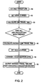
- FIG. 2 is a flowchart showing an exemplary method of smoothing navigation data.
- FIG. 1 is a block diagram showing an exemplary system for smoothing navigation data.
- This navigation system may be physically, conceptually, or functionally divided into, for example, a navigation apparatus N and an information communication system C, for example, installed in an information center.
- Navigation system N may be mounted in a vehicle.
- FIG. 1 shows a road traffic information communication system T (hereinafter also referred to as VICS®) that may be provided in a road traffic information center.
- VICS® road traffic information communication system
- the navigation system N may be provided with a current position detector 10 (such as, for example, a GPS receiver).
- the current position detector 10 may receive radio waves sent from an artificial satellite of a satellite navigation system (also known as GPS) to detect a current position of a vehicle as well as a present day and time.
- GPS satellite navigation system
- the navigation system N may be provided with an input unit 20.
- the input unit 20 may be, for example, a portable remote controller that may send required information to a controller 30 (described later).
- the input unit 20 may also be, for example, a touch panel provided on a display screen of a display device. Such a display device may be part of an output unit 60 (described later).
- the navigation system N may be provided with, for example, a controller 30, a memory 40, a communication unit 50, and/or an output unit 60.
- the controller 30 may include, for example, a CPU, a RAM, and/or a ROM and may be connected by, for example, bus lines.
- the controller 30 may control, for example, map display, route search, and/or route guidance of the vehicle based upon, for example, a current position that is obtained by, for example, the current position detector 10, operation of the input unit 20, information in the memory 40, communication from communication unit 50, and/or information from the information communication system C.
- the memory 40 may be, for example, a hard disk. Map data and/or traffic information data may be accumulated in the memory 40, for example, in a database or other data structure.
- the communication unit 50 may receive, for example, road traffic information from the information communication system C to output to the controller 30.
- the information communication system C may include, for example, a controller 70, a communication unit 80, and/or the memory 90.
- the communication unit 80 may execute wireless communication between the communication unit 50 and VICS T.
- the controller 70 may execute, for example, the exemplary methods shown in the flowcharts in Figs. 2 to 6.
- the controller 70 may also control the transfer of information between, for example, the communication unit 50 and VICS T via, for example, the communication unit 80.
- control programs may be stored in advance in, for example, a ROM of the controller 70.
- Link travel times TT, vehicle speeds, congestion degrees D, and/or traffic information data may be sent from VICS T and stored in the memory 90, for example, in a database or other data structure.
- a congestion degree D is a degree of traffic congestion determined by a vehicle speed and the congestion degree may include, for example, four-stage data, that is, for example, "congested,” “crowded,” “not congested,” and ''uncertain.'' According to this example, the degree of congestion decreases in the order of "congested,” "crowded,” and “not congested.”
- the congestion degree is not limited to four stages and may include a plurality of stages.
- VICS link length may be stored in the memory 90 as map data.
- the VICS link length is an actual length of a target link.
- each road may include a plurality of componential units called links.
- Each link may be separated and defined by, for example, an intersection, an intersection having more than three roads, a curve, and/or a point at which the road type changes.
- the output unit 60 may be, for example, a display unit. Under the control of the controller 30, the output unit 60 may display data.
- a display panel such as, for example, a liquid crystal panel of the output unit 60 may be disposed in an instrument panel that is provided in a front wall in a cabin of the vehicle.
- a target link is extracted from the map data stored in, for example, the memory 90.
- a target link represents a first or next link in a predetermined group of links.
- the predetermined group may be, for example, a group necessary for a route search, a group within a predetermined area of the map data, or a whole of the map data (such as all of Japan).
- a vehicle speed is set. Specifically, a vehicle speed corresponding to the congestion degree is set on the basis of, for example, the exemplary data in Table 1. Thus, on the basis of a congestion degree corresponding to the target link and included in the traffic information data, a vehicle speed corresponding to the congestion degree is set.
- Table 1 shows exemplary data indicating a relationship among, for example, vehicle speed, road type, and congestion degree.
- the road type mentioned herein may refer to, for example, a general road, an urban highway, an intercity highway, or any other type of road.
- the congestion degree is "congested,” “crowded,” or “not congested”
- the vehicle speed may be set to 5km/h, 15km/h, or 40km/h, respectively.
- the data such as that shown in exemplary Table 1 may be stored in the memory 90 in advance. Operation proceeds to step 120.
- a link travel time of the target link is calculated by dividing a link length of the target link by the set vehicle speed. Then, in step 130, it is determined whether a link travel time of every link in the predetermined group has been calculated. If a link travel time of every link in the predetermined group has not been calculated operation returns to step 100.
- step 140 an average or “smoothed" link time is calculated.
- the calculated link travel time may be denoted by T.
- An averaged link travel time T may be calculated using equation (1) shown below, on the basis of the one or more travel times T i for trip times previous to the calculated link travel time T, where i is the number of travel times for trip times previous to the calculated link travel time that will be used for the average. Thus, if two travel times for previous trip times are used the averaged link travel time T may be determined as ( T 1 + T 2 )/2. Operation continues to step S150.
- the term “smoothing” refers to bringing extreme or abnormal values in a data set closer to the remaining values in the data set. For example, when the data set is plotted, the extreme or normal values may create spikes in the data. Thus, by bringing the extreme or abnormal values closer to the remaining values the spikes may be “smoothed” out. It should be appreciated that smoothing may be accomplished by using, for example, means, medians, statistical interpolation, standard deviation, and/or any other method or means by which extreme values may be moved closer to remaining values in a data set.
- trip time refers to the time at which a link may be traveled. This is because a travel time for a particular link may vary depending on the time of day, day, and/or time of year.
- trip times may be set as predefined intervals such as, for example, 12 PM - 2 PM. Accordingly, a trip time previous to the 12 PM - 2 PM trip time may be 10 AM - 12 PM or 6 AM - 8 AM.
- the trip times may be defined by large or small intervals and may also be defined by or grouped into events, such as "morning rush hour,” “evening rush hour,” or "weekend.”
- a vehicle speed is set. Specifically, a vehicle speed of the target link is calculated by dividing a link length of the target link by the averaged link travel time T . Then in step 160, the set vehicle speed is converted into a congestion level. Specifically, for example, the set vehicle speed of each link is converted into a congestion degree based on, for example, the exemplary data in Table 2.
- the road type may refer to, for example, a general road, an urban highway, an intercity highway, or any other road type.
- a set vehicle speed which is expressed as Vkm/h
- Vkm/h a congestion degree such as, for example, "congested,” “slightly congested,” “crowded,” “slightly crowded,” or “not congested,” on the basis of, for example, V ⁇ 8km/h, 8km/h ⁇ V ⁇ 12km/h, 12km/h ⁇ V ⁇ 20km/h, 20km/h ⁇ V ⁇ 32km/h or 32km/h ⁇ V, respectively. Operation continues to step 170.
- step 170 the smoothed link travel time (e.g., step 140) and congestion degree (e.g., step 160) may be output to, for example, the memory 90 and/or the communication unit 80.
- the data may then, for example, be transmitted to the communication unit 50 by the communication unit 80.
- the controller 30 may store the smoothed link travel time in, for example, the memory 40.
- a vehicle speed corresponding to a congestion degree may be set for each target link in the predetermined group, and a link travel time may be calculated from a link length and the set vehicle speed. Then, for each extracted target link, a smoothed link travel time is calculated.
- This smoothed link travel time may be set as a link travel time in, for example, the traffic information for each extracted target link. Accordingly, if a particular link travel time is abnormally large or small compared to one or more previous travel times for the same link, the abnormal value of the link travel time may be counterbalanced in the average link travel time. If the average link travel time is set as a link travel time in the traffic information for each extracted target link, the traffic information may be more reliable by "smoothing out" any extreme or abnormal values. Further, in predicting traffic information by statistically processing an average link travel time, the quality of statistically processed data may be enhanced.
- the output unit 60 may correctly recognize a congestion degree of a searched route to be followed by the vehicle.
- the reliable traffic information may be accessed from the information communication system C from, for example, a home terminal.
- a smoothed link travel time at a predetermined trip time may be calculated by accumulating traffic information including a congestion degree at various trip times (calculated on the basis of the congestion degree) may be calculated by statistically processing link travel times at the plurality of trip times including a link travel time at the predetermined trip time.
- the link travel time calculated from traffic information may be smoothed by statistically processing the link travel times at the plurality of trip times including the link travel time at the predetermined trip time. Thereby, the link travel time may be smoothed and may be prevented from becoming abnormal and can be made more realistic and highly reliable.
- An average link travel time for each extracted target link may be an average of a plurality of link travel times, for example, two or four link travel times or the like including a current link travel time to be targeted. Further, the plurality of link travel times may be the current link travel time and link travel times following it.
- An average link travel time may be calculated by smoothing three link travel times, for example, through a processing of making an abnormal link travel time close to a normal period or the like, instead of averaging the link travel times. Furthermore, a statistically processed value such as a median and the respective calculated link travel times or the like may be adopted.
- the navigation system N may directly receive traffic information from the vehicle information communication system T and may perform at least part of the aforementioned exemplary methods for smoothing navigation data.
- Systems and methods of smoothing navigation data may accumulate traffic information including, for each link, a congestion degree at a plurality of trip times, calculate a link travel time on the basis of the congestion degree for each trip time, and smooth the calculated link travel time.
Applications Claiming Priority (4)
| Application Number | Priority Date | Filing Date | Title |
|---|---|---|---|
| JP2003434756 | 2003-12-26 | ||
| JP2003434756 | 2003-12-26 | ||
| JP2004266759A JP4007353B2 (ja) | 2003-12-26 | 2004-09-14 | ナビゲーションシステムにおける交通情報処理装置 |
| JP2004266759 | 2004-09-14 |
Publications (1)
| Publication Number | Publication Date |
|---|---|
| EP1548405A1 true EP1548405A1 (de) | 2005-06-29 |
Family
ID=34554890
Family Applications (1)
| Application Number | Title | Priority Date | Filing Date |
|---|---|---|---|
| EP04030461A Withdrawn EP1548405A1 (de) | 2003-12-26 | 2004-12-22 | System, Verfahren und Datastruktur für Mittelung der Navigationsdaten |
Country Status (4)
| Country | Link |
|---|---|
| US (1) | US20050143906A1 (de) |
| EP (1) | EP1548405A1 (de) |
| JP (1) | JP4007353B2 (de) |
| CN (1) | CN1637383A (de) |
Families Citing this family (21)
| Publication number | Priority date | Publication date | Assignee | Title |
|---|---|---|---|---|
| JP3791533B2 (ja) * | 2003-12-26 | 2006-06-28 | アイシン・エィ・ダブリュ株式会社 | 交通情報データの補正方法、補正装置及び交通情報データ構造 |
| KR100711866B1 (ko) * | 2005-05-18 | 2007-04-25 | 엘지전자 주식회사 | 소통상태에 대한 예측정보를 제공하고 이를 이용하는 방법및 장치 |
| KR20060119743A (ko) * | 2005-05-18 | 2006-11-24 | 엘지전자 주식회사 | 구간 속도에 대한 예측정보를 제공하고 이를 이용하는 방법및 장치 |
| US7729335B2 (en) * | 2005-05-18 | 2010-06-01 | Lg Electronics Inc. | Providing traffic information relating to a prediction of congestion status and using the same |
| KR20060119741A (ko) * | 2005-05-18 | 2006-11-24 | 엘지전자 주식회사 | 소통상태의 추이정보를 제공하고 이를 이용하는 방법 및장치 |
| KR20060119746A (ko) | 2005-05-18 | 2006-11-24 | 엘지전자 주식회사 | 교통상태에 대한 정보를 제공하고 이를 이용하는 방법 및장치 |
| KR20060119742A (ko) * | 2005-05-18 | 2006-11-24 | 엘지전자 주식회사 | 도로 정보를 제공하고 이를 이용하는 방법 및 장치 |
| KR20060119739A (ko) * | 2005-05-18 | 2006-11-24 | 엘지전자 주식회사 | 구간 통과시간에 대한 예측정보를 제공하고 이를 이용하는방법 및 장치 |
| KR20060122668A (ko) * | 2005-05-27 | 2006-11-30 | 엘지전자 주식회사 | 교통 정보 제공 방법 및 수신 장치 |
| US8711850B2 (en) * | 2005-07-08 | 2014-04-29 | Lg Electronics Inc. | Format for providing traffic information and a method and apparatus for using the format |
| KR101254219B1 (ko) * | 2006-01-19 | 2013-04-23 | 엘지전자 주식회사 | 링크 식별 방법 및 링크 식별 장치 |
| JP4891792B2 (ja) * | 2007-01-26 | 2012-03-07 | クラリオン株式会社 | 交通情報配信方法および交通情報配信装置 |
| JP4539666B2 (ja) | 2007-03-19 | 2010-09-08 | アイシン・エィ・ダブリュ株式会社 | 渋滞状況演算システム |
| JP2009229199A (ja) * | 2008-03-21 | 2009-10-08 | Pioneer Electronic Corp | 到着予定時間算出装置、及び到着予定時間算出方法等 |
| JP5424754B2 (ja) * | 2009-07-13 | 2014-02-26 | 株式会社豊田中央研究所 | リンク旅行時間算出装置及びプログラム |
| CN101739820B (zh) * | 2009-11-19 | 2012-09-26 | 北京世纪高通科技有限公司 | 路况预测的方法及装置 |
| JP5648009B2 (ja) * | 2012-03-21 | 2015-01-07 | アイシン・エィ・ダブリュ株式会社 | 交通情報作成装置、交通情報作成方法及びプログラム |
| CN102867412B (zh) * | 2012-09-24 | 2014-09-10 | 东南大学 | 一种城市道路可变短车道设置方法 |
| CN102890869B (zh) * | 2012-09-25 | 2015-01-14 | 孙涛 | 车辆行车路线预测通知方法及移动智能终端 |
| CN106781470B (zh) * | 2016-12-12 | 2022-01-28 | 百度在线网络技术(北京)有限公司 | 城市道路的运行速度的处理方法及装置 |
| CN111145544B (zh) * | 2019-12-25 | 2021-05-25 | 北京交通大学 | 一种基于拥堵蔓延消散模型的行程时间及路径预测方法 |
Citations (3)
| Publication number | Priority date | Publication date | Assignee | Title |
|---|---|---|---|---|
| US5822712A (en) * | 1992-11-19 | 1998-10-13 | Olsson; Kjell | Prediction method of traffic parameters |
| WO1998059329A1 (de) * | 1997-06-24 | 1998-12-30 | Siemens Aktiengesellschaft | Verfahren zur ermittlung einer tageszeitabhängigen reisezeit |
| US20010029425A1 (en) * | 2000-03-17 | 2001-10-11 | David Myr | Real time vehicle guidance and traffic forecasting system |
Family Cites Families (4)
| Publication number | Priority date | Publication date | Assignee | Title |
|---|---|---|---|---|
| US6061628A (en) * | 1996-04-24 | 2000-05-09 | Aisin Aw Co., Ltd. | Navigation system for vehicles |
| EP1077362B1 (de) * | 1999-08-17 | 2004-05-26 | Toyota Jidosha Kabushiki Kaisha | Routenführungsvorrichtung |
| JP3801433B2 (ja) * | 2000-10-02 | 2006-07-26 | アイシン・エィ・ダブリュ株式会社 | ナビゲーション装置およびその記憶媒体 |
| US6587780B2 (en) * | 2001-04-09 | 2003-07-01 | Koninklijke Philips Electronics N.V. | System and method for disseminating traffic information |
-
2004
- 2004-09-14 JP JP2004266759A patent/JP4007353B2/ja not_active Expired - Fee Related
- 2004-12-03 US US11/002,811 patent/US20050143906A1/en not_active Abandoned
- 2004-12-22 EP EP04030461A patent/EP1548405A1/de not_active Withdrawn
- 2004-12-24 CN CN200410103667.0A patent/CN1637383A/zh active Pending
Patent Citations (3)
| Publication number | Priority date | Publication date | Assignee | Title |
|---|---|---|---|---|
| US5822712A (en) * | 1992-11-19 | 1998-10-13 | Olsson; Kjell | Prediction method of traffic parameters |
| WO1998059329A1 (de) * | 1997-06-24 | 1998-12-30 | Siemens Aktiengesellschaft | Verfahren zur ermittlung einer tageszeitabhängigen reisezeit |
| US20010029425A1 (en) * | 2000-03-17 | 2001-10-11 | David Myr | Real time vehicle guidance and traffic forecasting system |
Also Published As
| Publication number | Publication date |
|---|---|
| CN1637383A (zh) | 2005-07-13 |
| US20050143906A1 (en) | 2005-06-30 |
| JP4007353B2 (ja) | 2007-11-14 |
| JP2005209153A (ja) | 2005-08-04 |
Similar Documents
| Publication | Publication Date | Title |
|---|---|---|
| EP1548405A1 (de) | System, Verfahren und Datastruktur für Mittelung der Navigationsdaten | |
| US7680588B2 (en) | Traffic information management system | |
| US7660663B2 (en) | Traffic information transmitting apparatus, transmitting method, and transmitting program | |
| US8744767B2 (en) | Segment defining method, travel time calculation device, and driving support device | |
| EP2181904B1 (de) | System zur Bewertung sicheren Fahrens und Programm zur Bewertung sicheren Fahrens | |
| US7890246B2 (en) | Method of interpolating traffic information data, apparatus for interpolating, and traffic information data structure | |
| US20150066270A1 (en) | Movement information processing device, movement information processing method, and driving assistance system | |
| JP2007011558A (ja) | 渋滞予測装置および方法 | |
| US20100057334A1 (en) | Method and system to estimate vehicle traffic conditions | |
| US8260532B2 (en) | Traffic probe in-vehicle map-based process to reduce data communications and improve accuracy | |
| JP6927088B2 (ja) | 走行データ収集システム、走行データ収集センタ、及び車載端末 | |
| JP5942907B2 (ja) | 経路探索装置、経路探索システム | |
| US20050251329A1 (en) | Navigation apparatus, navigation method, and navigation program | |
| JP4082420B2 (ja) | 旅行時間推定システム、装置及び方法 | |
| US11662215B2 (en) | Method, apparatus, and computer program product for anonymizing trajectories | |
| JP5745070B2 (ja) | 局地的な交通流を推計するシステムおよび方法 | |
| EP2287821B1 (de) | Verfahren und Vorrichtung zum Bestimmen von Verkehrsinformationen und System zur Routenberechnung | |
| JP4142802B2 (ja) | 車両用ナビゲーション装置 | |
| US7672775B2 (en) | Systems, methods, and data structures for correcting traffic information | |
| JP2003344074A (ja) | 情報提供システム | |
| JP2008242794A (ja) | 交通情報送信装置、交通情報配信サーバ及び交通情報配信システム | |
| JP2004125429A (ja) | ナビゲーションシステム、ナビゲーションセンタ、車載ナビゲーション装置、およびナビゲーション方法 | |
| JP3784171B2 (ja) | ナビゲーション装置 | |
| JP2004145587A (ja) | 走行車両位置推定装置および方法 | |
| JP4989429B2 (ja) | 車両用情報処理装置、及び交通情報収集提供システム |
Legal Events
| Date | Code | Title | Description |
|---|---|---|---|
| PUAI | Public reference made under article 153(3) epc to a published international application that has entered the european phase |
Free format text: ORIGINAL CODE: 0009012 |
|
| AK | Designated contracting states |
Kind code of ref document: A1 Designated state(s): AT BE BG CH CY CZ DE DK EE ES FI FR GB GR HU IE IS IT LI LT LU MC NL PL PT RO SE SI SK TR |
|
| AX | Request for extension of the european patent |
Extension state: AL BA HR LV MK YU |
|
| 17P | Request for examination filed |
Effective date: 20051213 |
|
| AKX | Designation fees paid |
Designated state(s): DE FR GB |
|
| STAA | Information on the status of an ep patent application or granted ep patent |
Free format text: STATUS: THE APPLICATION HAS BEEN WITHDRAWN |
|
| 18W | Application withdrawn |
Effective date: 20071024 |