WO2021002218A1 - コンピュータシステムおよび記憶媒体並びにプログラム - Google Patents
コンピュータシステムおよび記憶媒体並びにプログラム Download PDFInfo
- Publication number
- WO2021002218A1 WO2021002218A1 PCT/JP2020/024063 JP2020024063W WO2021002218A1 WO 2021002218 A1 WO2021002218 A1 WO 2021002218A1 JP 2020024063 W JP2020024063 W JP 2020024063W WO 2021002218 A1 WO2021002218 A1 WO 2021002218A1
- Authority
- WO
- WIPO (PCT)
- Prior art keywords
- route
- information
- user
- movement
- data
- Prior art date
- Legal status (The legal status is an assumption and is not a legal conclusion. Google has not performed a legal analysis and makes no representation as to the accuracy of the status listed.)
- Ceased
Links
Images


Classifications
-
- G—PHYSICS
- G01—MEASURING; TESTING
- G01C—MEASURING DISTANCES, LEVELS OR BEARINGS; SURVEYING; NAVIGATION; GYROSCOPIC INSTRUMENTS; PHOTOGRAMMETRY OR VIDEOGRAMMETRY
- G01C21/00—Navigation; Navigational instruments not provided for in groups G01C1/00 - G01C19/00
- G01C21/26—Navigation; Navigational instruments not provided for in groups G01C1/00 - G01C19/00 specially adapted for navigation in a road network
- G01C21/34—Route searching; Route guidance
-
- G—PHYSICS
- G06—COMPUTING OR CALCULATING; COUNTING
- G06Q—INFORMATION AND COMMUNICATION TECHNOLOGY [ICT] SPECIALLY ADAPTED FOR ADMINISTRATIVE, COMMERCIAL, FINANCIAL, MANAGERIAL OR SUPERVISORY PURPOSES; SYSTEMS OR METHODS SPECIALLY ADAPTED FOR ADMINISTRATIVE, COMMERCIAL, FINANCIAL, MANAGERIAL OR SUPERVISORY PURPOSES, NOT OTHERWISE PROVIDED FOR
- G06Q50/00—Information and communication technology [ICT] specially adapted for implementation of business processes of specific business sectors, e.g. utilities or tourism
- G06Q50/40—Business processes related to the transportation industry
-
- G—PHYSICS
- G08—SIGNALLING
- G08G—TRAFFIC CONTROL SYSTEMS
- G08G1/00—Traffic control systems for road vehicles
- G08G1/005—Traffic control systems for road vehicles including pedestrian guidance indicator
-
- G—PHYSICS
- G09—EDUCATION; CRYPTOGRAPHY; DISPLAY; ADVERTISING; SEALS
- G09B—EDUCATIONAL OR DEMONSTRATION APPLIANCES; APPLIANCES FOR TEACHING, OR COMMUNICATING WITH, THE BLIND, DEAF OR MUTE; MODELS; PLANETARIA; GLOBES; MAPS; DIAGRAMS
- G09B29/00—Maps; Plans; Charts; Diagrams, e.g. route diagram
- G09B29/10—Map spot or coordinate position indicators; Map reading aids
Definitions
- One aspect of this disclosure relates to computer systems and / or programs.
- Patent Document 1 a technique for providing a user with a movement route from a starting point to a destination has been known (see, for example, Patent Document 1).
- One aspect of this disclosure is to properly manage the travel route from the starting point to the destination.
- the route information associated with at least one piece of information on the candidate route searched as a candidate is made available to the business operator.
- FIG. 1 It is a figure which shows an example of application of the information sharing system which concerns on embodiment. It is a figure which shows an example of the hardware configuration of the platformer server which concerns on embodiment. It is a figure which shows the example of the data structure of the movement data. It is a figure which shows the example of the data structure of the movement data. It is a figure which shows the example of the data structure of the movement data. It is a figure which shows an example of the functional structure of the platformer server which concerns on embodiment. It is a flowchart which shows an example of the operation of the information sharing system which concerns on embodiment. It is a figure which shows an example of the result of a route search. It is a figure which shows an example of the movement data corresponding to the search result shown in FIG.
- the information sharing system 1 is a computer system that searches for a movement route from a departure point to a destination designated by the user and provides the movement route to the user.
- the user is a person who obtains a movement route by using the information sharing system 1.
- the user may be an individual or a group of multiple people.
- the departure point is a place set as a start point for searching a travel route
- a destination is a place set as an end point for the search. Both the starting point and the destination are reference points for route search.
- the movement route is information about movement from one point to another.
- the movement route can indicate not only the route from the starting point to the destination but also the attribute of the route (hereinafter referred to as "route attribute").
- route attribute is arbitrary information that represents the nature, characteristics, or situation of a route.
- route attributes include transportation means such as transportation, the time or cost required to travel the route, the status of the route (for example, traffic information), and the features related to the route (that is, feature information). It may include at least one of a business operator related to the route (that is, business information) and service information related to the route (for example, advertising information, coupon information, etc.).
- a feature is any tangible or intangible object that exists on the ground.
- the feature may be a natural object or an artificial object.
- features can include mountains, farmlands, residential areas, vacant lots, rivers, lakes, seas, tourist destinations, roads, railroads, buildings, parks, towers, traffic lights, railroad crossings, pedestrian crossings, pedestrian bridges, floats, and the like.
- intangible features include areas set for arbitrary purposes (eg, photography prohibited areas, temporary exclusion zones, etc.), areas where events are held, meeting places, shooting spots, and the like. ..
- the types of features are not limited to these.
- the information sharing system 1 plays a role of comprehensively controlling or managing information related to the movement of people.
- the information sharing system 1 searches for one or more suitable travel routes from options including various modes of transportation or means of transportation and provides the travel routes to the user.
- the information sharing system 1 generates movement data including a combination of a user and a movement route and a movement ID which is an identifier corresponding to this combination, and stores the movement data in a given database. This movement data can be used for various purposes.
- the information sharing system 1 serves as a movement route that can be provided or used between various users and various businesses, or a platform that comprehensively controls or manages various information related to the movement route. Can be fulfilled.
- the administrator or operator of the information sharing system 1 can be a platformer.
- the information sharing system 1 can provide the movement data to any number of businesses that provide any service related to movement.
- the operator can provide the service or information to the user based on the movement data, and the user can obtain the service or information.
- the information sharing system 1 can provide the user with various information such as traffic information, advertisements, coupons, and facility information based on the movement data.
- the operator can perform various statistics or analyzes based on the travel data and perform various processes such as proposals, evaluations, and plans based on the results obtained.
- the business operators related to the information sharing system 1 are not limited. Examples of businesses include various transportation businesses such as railroads, buses, taxis, planes, and ships, rental businesses for various means of transportation such as automobiles and bicycles, vehicle dispatch service businesses, and shopping. Examples include businesses that operate various facilities such as restaurants and parking lots, businesses that provide various information such as advertisements and coupons, payment businesses, and various organizations of the national or local governments.
- the service or information provided to the user is also not limited.
- Examples of services or information include route guidance, timetables, reservations, rentals, vehicle allocation, facility information, advertisements, payments, coupons, real estate information, statistical information, marketing information.
- the information sharing system 1 can be used for MaaS, that is, "mobility as a service”. However, the use of the information sharing system 1 is not limited to this, and the information sharing system 1 can be used for various purposes.
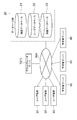
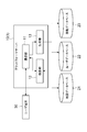
- FIG. 1 is a diagram showing an example of application of the information sharing system 1.
- the information sharing system 1 includes a platformer server 10 which is a computer that provides a movement route to a user.
- the platform server 10 connects to the database group 20, one or more user terminals 30, and one or more operator servers 40 via the communication network NW.
- the platform server 10 is a computer that executes the main functions of the information sharing system 1.
- the computer that functions as the platform server 10 is not limited.
- the platform server 10 is composed of a large computer such as a business server.
- FIG. 2 shows an example of the hardware configuration of the platform server 10.
- the platform server 10 has a control circuit 100.
- the control circuit 100 has one or more processors 101, a memory 102, a storage 103, a communication port 104, and an input / output port 105.
- Processor 101 executes the operating system and application programs.
- the storage 103 is composed of a hard disk, a non-volatile semiconductor memory, or a storage medium of a retrievable medium (for example, a magnetic disk, an optical disk, etc.) and stores an operating system and an application program.
- the memory 102 temporarily stores the program loaded from the storage 103 or the calculation result by the processor 101.
- the processor 101 functions as each of the above functional modules by executing a program in cooperation with the memory 102.
- the communication port 104 performs data communication with another device via the communication network NW in accordance with a command from the processor 101.
- the input / output port 105 executes input / output of an electric signal to / from an input / output device (user interface) such as a keyboard, a mouse, and a monitor according to a command from the processor 101.
- the platform server 10 may be composed of one or more computers. When a plurality of computers are used, one platformer server 10 is logically configured by connecting these computers to each other via a communication network.
- the database group 20 is a set of databases that store necessary data in the information sharing system 1.
- the database group 20 includes a map database 21, a user database 22, and a mobile database 23.
- Each database may be constructed as a part of the information sharing system 1, or may be provided in a computer system different from the information sharing system 1.
- the platform server 10 can access individual databases to read and write data.
- the map database 21 is a non-temporary storage medium or storage device that permanently stores map data indicating map elements constituting the map.
- map elements include nodes and links.
- a node is a position set to control the movement of a moving body, and more specifically, a position where a moving method (for example, direction, speed, etc.) of the moving body can be changed. ..
- At least some of the nodes can be transportation hubs.
- a transportation hub is a place where multiple modes of transportation of the same type or different types are connected.
- a link is a virtual line set to indicate a route and connects adjacent nodes. The shape of the link may be a straight line or a curved line, or may be a combination of a straight line and a curved line.
- the shape of the link can depend on the shape of the road.
- the location where nodes and links are set is not limited, for example, nodes and links can be set above ground, underground, in the air, above water, or underwater. There may be multiple links connecting the two nodes. For example, two nodes may be connected by both a railroad link and a road link.
- the map data may be configured to include node data indicating a plurality of nodes and link data indicating a plurality of links.
- node data includes node IDs, coordinates, and node attributes as data items.
- the node ID is an identifier that uniquely identifies each node.
- the coordinates are values that indicate the two-dimensional or three-dimensional geographical position of the node. The method of setting the coordinates is not limited, and for example, the coordinates may be expressed using latitude and longitude, or may be set according to any other coordinate system.
- a node attribute is arbitrary information that represents the nature, characteristics, or status of a node.
- the node attribute may include a nodal flag, which is a binary indicating whether or not the node is a transportation hub.
- the node attribute may include feature information about the feature related to the node, or may include the operator information about the operator related to the node.
- the link data includes a link ID, a first node ID, a second node ID, and a link attribute as data items.
- the link ID is an identifier that uniquely identifies each link. Both the first node ID and the second node ID are node IDs that identify the node located at the end of the link.
- Link attributes are arbitrary information that describes the nature, characteristics, or circumstances of a link. For example, link attributes include transportation means such as transportation, the time or cost required to move the link, the status of the link (eg traffic information), and the features related to the link (ie feature information). It may include at least one of the business operator related to the link (that is, business information) and the service information related to the link (for example, advertising information, coupon information, etc.).
- the user database 22 is a non-temporary storage medium or storage device that permanently stores user data related to the user.
- user data includes user IDs and user attributes as data items.
- the user ID is an identifier that uniquely identifies each user.
- User attributes are arbitrary information that represents the nature, characteristics, or circumstances of the user.
- the user attribute may include various information such as name, gender, age, means of transportation possessed, and barrier information.
- Barrier information refers to matters that should or should be considered when the user moves.
- the barrier information may indicate matters such as the necessity of a wheelchair, pregnancy, and old age.
- the mobile database 23 is a non-temporary storage medium or storage device that permanently stores mobile data.
- travel data includes travel IDs, user IDs, and at least one travel path as data items.
- the method of setting the movement ID is not limited.
- one identifier may be set as the movement ID corresponding to the combination of the user ID and one or more movement routes extracted in one search process.
- one unique movement ID is set for the combination of the user ID and the set of one or more movement routes.
- a user ID and a movement ID that uniquely identifies the combination of the movement routes may be set for each of the one or more movement routes extracted in one search process. In this case, one unique movement ID is set for the combination of the user ID and one movement route.
- the data structure of the movement data may be designed according to any policy.
- the information sharing system 1 may generate movement data indicating a movement route by using a plurality of node IDs and a plurality of link IDs.
- the node ID and the link ID constituting the movement route may be only the node ID of the specific node and the link ID of the link connecting the specific nodes.
- the particular node may be a node of a transportation hub.
- the information sharing system 1 may generate movement data including route attributes.
- a route attribute is arbitrary information that represents the nature, characteristics, or situation of a route.
- the route attribute may indicate whether the travel route is searched as a candidate, selected by the user, or actually used by the user.
- the movement route searched as a candidate is referred to as a "candidate route”
- the movement route selected by the user is referred to as a "planned route”
- the movement route actually used by the user is referred to as a "actual route”. ..
- a movement route selected and used by a user as one movement route is also referred to as a "planned / actual route”.
- the route attribute indicates at least one of the route searched as a candidate, the route selected by the user, and the route actually used by the user.
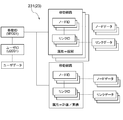
- FIGS. 3 to 5 are diagrams showing an example of the data structure of the moving data.
- one unique movement ID "M1001" is assigned to the plurality of searched movement routes.
- the movement data 232 shown in FIG. 4 one unique movement ID is assigned to each of the three searched movement routes.
- movement data 232a, 232b, and 232c corresponding to the three movement paths are generated, and the movement IDs of these movement data are set to "M1001", "M1002", and "M1003", respectively.
- the information sharing system 1 may generate movement data for each of the searched one or more movement routes.
- a unique movement ID "M1001" is assigned only to the movement route selected or used by the user among the one or more searched movement routes.
- the information sharing system 1 does not generate movement data for the movement routes not selected by the user among the one or more searched movement routes, and the information sharing system 1 of the searched one or more movement routes.
- movement data may be generated for the movement route selected or used by the user.
- the moving data may have any other data structure.
- the computer can refer to the user data corresponding to the user ID and the node data and the link data corresponding to the individual nodes and individual links constituting the movement route.
- the computer can identify the user ID associated with the mobile ID by referring to the mobile ID, and can refer to the user attribute (that is, the user's attribute information) associated with the user ID. it can.
- the computer can identify the node ID associated with the mobile ID by referring to the mobile ID, and can refer to the node attribute (that is, the attribute information of the node) associated with the node ID.
- the computer can identify the link ID associated with the mobile ID and refer to the link attribute (that is, the attribute information of the link) associated with the link ID.
- the computer can access the map database 21 and the user database 22 based on these IDs to acquire various attribute information.
- the movement data may include at least one of at least some user attributes, at least some node attributes, and at least some link attributes. This means that at least a part of the attribute information is denormalized and retained in the database group 20.
- Individual data items of individual data may be set statically or dynamically.
- Statically set means that the value is preset and the setting is not changed unless there is manual intervention.
- dynamically set means that the value can be changed according to an arbitrary event without manual intervention. Dynamic configuration is achieved by running a program that controls a given data item on a given computer. The dynamic settings may be performed by the information sharing system 1 or by another computer system.
- the structure of individual data is not limited, and the data structure may be designed according to any policy.
- at least one of map data, user data, and movement data may be normalized or denormalized by an arbitrary policy and stored on one or more data tables.
- map data, user data, and movement data are shared among multiple operators. Therefore, each business operator can efficiently obtain information on the movement of the user from the information sharing system 1 and use the information.
- the operator can provide various services or information related to the movement of the user, or process the information related to the movement of the user by an arbitrary method.
- the platformer can provide a user with a cross-sectional service or information across multiple transportation operators, and the user can enjoy the service or information.
- at least a part of the information about each of the node attribute and the link attribute which can save the number of databases and the data capacity in the entire information sharing system 1, is provided by the operator. It may be provided, for example, from the database of an individual operator. Alternatively, the databases of the individual operators may play at least part of the role of the map database 21.
- the user terminal 30 is a computer operated by the user.
- the user terminal 30 may be a fixed terminal or a mobile terminal. Examples of the user terminal 30 include mobile phones, smartphones, tablet terminals, wearable terminals, and personal computers, but the types of terminals are not limited thereto.
- the number of user terminals 30 that access the information sharing system 1 is not limited.
- the business server 40 is a computer managed or operated by the business.
- the computer that functions as the operator server 40 is not limited.
- the business server 40 may be configured by a large computer such as a business server, or may be configured by a personal computer.
- the number of business server 40s that access the information sharing system 1 is not limited.
- FIG. 6 is a diagram showing an example of the functional configuration of the platform server 10.
- the platform server 10 includes a communication unit 11, a search unit 12, and a generation unit 13 as functional modules.
- the communication unit 11 is a functional module that transmits / receives data to / from another computer.
- the search unit 12 is a function module for searching a movement route.
- the generation unit 13 is a functional module that generates and stores movement data.
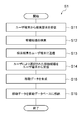
- FIG. 7 is a flowchart showing an example of the operation of the information sharing system 1 as a processing flow S1.
- step S11 the communication unit 11 receives the search condition from the user terminal 30.
- the user operates the user terminal 30, inputs information necessary for route search, and instructs transmission of the information.
- the user terminal 30 generates a search condition in response to the operation, and transmits the search condition to the platform server 10.
- the communication unit 11 receives the search condition.
- the search condition is a data signal indicating at least a starting point and a destination specified by the user.
- the search condition may further include other data items such as at least one of the departure date and time and the arrival date and time, at least one waypoint.
- the search condition may include a data item relating to the user, for example, may include a user ID, or may further include at least one data item relating to the user attribute.
- the search unit 12 searches for a movement route that satisfies the search condition.
- the search unit 12 extracts the movement route by searching the map data in the map database 21 based on the search conditions.
- the search condition includes data items related to the user
- the search unit 12 may refer to the user data in the user database 22 in addition to the map database 21.
- the search unit 12 may search for a plurality of movement routes, for example, a plurality of movement routes having different routes, a plurality of movement routes having the same route but different transportation means or travel dates and times, or both of these movement routes. You may search for.
- the search unit 12 can extract a plurality of movement routes corresponding to various movement methods provided by various businesses. That is, the search unit 12 can collectively search a plurality of movement routes in the form of crossing a plurality of transportation companies, which can be said to be an example of MaaS.
- step S13 the communication unit 11 transmits the search result to the user terminal 30.
- the search result is a data signal indicating one or more searched movement routes.
- the user terminal 30 receives and displays the search result, whereby the user can confirm the search result.
- step S14 the communication unit 11 receives the movement route selected by the user from the user terminal 30.
- the user operates the user terminal 30 to select a desired movement route.
- the user terminal 30 transmits information indicating the selected movement route to the platform server 10.
- the communication unit 11 receives the information.
- step S15 the generation unit 13 generates movement data.
- the generation unit 13 generates movement data including a combination of the user and the selected movement route and a movement ID corresponding to this combination.
- the data structure of the moving data is not limited, so that the specific method of generating the moving data is not limited.
- the generation unit 13 generates movement data by associating the user ID, the movement route selected by the user, and the movement ID with each other.
- the generation unit 13 may set a route attribute so as to indicate that the movement route is a planned route.
- the generation unit 13 may generate movement data indicating a movement route presented to the user as a candidate but not selected by the user.
- the generation unit 13 can specify the movement route by acquiring the search result from the search unit 12.
- the generation unit 13 generates movement data by associating a user ID, a plurality of movement routes corresponding to search results, and one movement ID with each other.
- the generation unit 13 sets the route attributes of a plurality of movement routes. Specifically, the generation unit 13 may set the route attribute of the movement route selected by the user to "plan" and the route attribute of the movement route not selected by the user to "candidate".
- the generation unit 13 may generate movement data for each of the plurality of movement routes corresponding to the search results.
- the generation unit 13 generates movement data by associating the user ID, the movement route, and the movement ID with each other for each of the plurality of movement routes.
- the generation unit 13 sets the route attribute for each movement route. Specifically, the generation unit 13 indicates that the movement route selected by the user is a planned route, and indicates that the route not selected by the user is a candidate route in each movement data. Set attributes.
- step S16 the generation unit 13 stores the movement data in the movement database 23.
- the movement data can be shared by a plurality of businesses.
- FIG. 8 is a diagram showing an example of the result of the route search.
- FIG. 9 is a diagram showing an example of moving data corresponding to the search result.
- the search unit 12 passes through the movement routes 301 that sequentially pass through the nodes A, B, and E and the nodes A, F, H, and D as the movement routes from the departure point S to the destination G. It is assumed that the moving route 302 to be used and the moving route 303 passing through the nodes A, B, C, and D in order are extracted. After that, it is assumed that the user having the user ID "U2101" selects the movement route 303.
- the generation unit 13 may generate the movement data 234 shown in FIG. 9, for example.
- the movement ID "M1101" of the movement data 234 corresponds to the combination of the user ID and the movement route 301, the combination of the user ID and the movement route 302, and the combination of the user ID and the movement route 303. Since the user has selected the movement route 303, the generation unit 13 sets the route attribute of the movement route 303 to "plan” and sets the route attributes of the movement routes 301 and 302 to "candidates".
- FIG. 10 is a diagram showing an example of route search.
- the information sharing system 1 can collectively search a plurality of travel routes in the form of crossing a plurality of transportation companies.
- the information sharing system 1 has a transportation means 61 provided by the business operator P, a transportation means 62 provided by the business operator Q, and a business operator as a movement route from the departure point S to the destination G.
- the search result based on the combination with the transportation means 63 provided by R is provided.
- the user 51 can select a desired movement route from this search result.
- FIG. 11 is a diagram showing an example of using the movement route selected by the user 52.
- the user 52 is a person using a wheelchair.
- the user 52 can use the user terminal 30 to obtain various service information regarding the route to be followed, such as traffic information, information on surrounding facilities, weather forecast, advertisement, coupon, and the like.
- the user 52 can also make various reservations, such as seat reservations and assistant assistants, using the user terminal 30.
- each business operator can grasp in advance what kind of person will use the transportation system and take necessary measures.
- the operators P and R corresponding to the means of transportation 61 and 63 can each have staff to assist in getting on and off for the user 52 who moves in a wheelchair.
- FIG. 12 is a diagram showing an example of payment regarding the movement route used by the user 53.
- the movement data stored in the movement database 23 enables various processing.
- the movement data contributes to visualization of various events related to the movement of people. Below are various examples of the use of mobile data.
- the travel route may include information about the parking lot, for example, parking lot location, availability, or fees.
- the travel route may include information or suggestions regarding carpooling.
- Examples of service information provided to users regarding selected travel routes include advertisements or coupons for transportation or facilities, optimal boarding location guidance for transfers, detour guidance for the same amount, and alternative transportation options.
- Reservations related to the selected travel route can also be realized. Examples of such reservations include reservations for transportation seats, parking lots, use of various facilities, assistants, and the like.
- Payments related to the selected travel route may also be realized. Examples of such payments include payment of the difference from the commuter pass, automatic payment without using a ticket gate, payment by splitting the bill, proposal of discounts, and automation of corporate transportation expense settlement.
- the accumulated movement data may be used for various statistics or analysis.
- travel data includes congestion calculation, new route proposals, demand forecasts, verification of differences between selected and unselected routes, marketing or advertising proposals, real estate price valuation or determination, It can be used for city planning or transportation planning, facility evaluation, waiting time prediction, traffic analysis, inventory optimization, transportation timetable optimization, guidance optimization by signage, etc.
- the program for making the computer function as the platform server 10 includes a program code for making the computer function as a communication unit 11, a search unit 12, and a generation unit 13.
- This program may be provided after being fixedly recorded on a non-temporary recording medium such as a CD-ROM, a DVD-ROM, or a semiconductor memory. Alternatively, the program may be provided via a communication network as a data signal superimposed on a carrier wave.
- the provided program is stored in the storage 103, and each of the above functional modules is realized by the processor 101 executing the program in cooperation with the memory 102.
- the computer system includes at least one processor.
- At least one processor refers to a map database that stores map data shared among a plurality of operators, and one or more movements corresponding to a search condition indicating at least a starting point and a destination specified by a user.
- a route is searched, and for each of at least one of the searched one or more movement routes, movement data in which the user and the combination of the movement routes and the movement ID corresponding to the combination are associated with each other is generated. Then, the movement data is stored in the movement database so that the generated movement data can be shared by a plurality of businesses.
- the program according to one aspect of the present disclosure refers to a map database that stores map data shared among a plurality of businesses, and corresponds to a search condition indicating at least a starting point and a destination specified by a user. For each of the step of searching for one or more movement routes and at least one of the searched movement routes, the combination of the user and the movement route and the movement ID corresponding to the combination are associated with each other.
- the computer is made to perform a step of generating the generated movement data and a step of storing the movement data in the movement database so that the generated movement data can be shared by a plurality of businesses.
- the movement data in which the movement ID is associated with the combination of the user and the movement route is registered in the database. Since the individual correspondence between the user and the movement route can be grasped from this movement data, it becomes possible to appropriately manage the movement route from the departure point to the destination.
- the mobile ID may be an identifier that uniquely identifies the combination.
- the individual correspondence between the user and the movement route can be identified using only the movement ID.
- At least one processor may generate movement data for each of one or more searched movement paths.
- the correspondence with the user can be managed by using the movement ID for all the searched movement routes regardless of whether or not they are selected by the user.
- At least one processor searches for one or more travel paths without generating travel data for travel routes that are not selected by the user among one or more searched travel routes.
- movement data may be generated for the movement route selected or used by the user.
- At least one processor may generate movement data indicating a movement route by a plurality of node IDs and a plurality of link IDs.
- the node ID is an identifier that uniquely identifies the node that constitutes the map, and is associated with the attribute information of the node.
- the link ID is an identifier that uniquely identifies a link connecting adjacent nodes, and is associated with the attribute information of the link.
- the node may be a transportation hub.
- the nodes By limiting the nodes to traffic nodes, which are important places in the movement route, the characteristics of each movement route can be accurately expressed by the movement data.
- the number of node IDs used to represent the movement route is suppressed, the data size of individual movement data can be suppressed.
- At least one processor indicates a route attribute indicating at least one of a route searched as a candidate, a route selected by the user, and a route actually used by the user. You may generate movement data including. By embedding such a route attribute in the movement data, the relationship between the user and the movement route can be specified from the movement data.
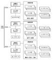
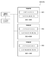
- FIG. 13 is a diagram showing another example of the data structure of the movement data.
- Reference numeral 500 denotes basic information, which includes the information described below.
- Reference numeral 510 is a movement ID, which is management information for uniquely identifying the information obtained by the combination of the basic information 500, the planned route information 600, and the actual route information 700.
- Reference numeral 520 is a user ID, which is an identifier that uniquely identifies the user. This user ID may be anonymized or encrypted so that an individual cannot be identified when associated with other data items. By doing so, the business operator can obtain information on the movement of the user as information on the destination of the user in a form that does not identify an individual, and data distribution that meets the request for protection of personal information becomes possible.
- 530 is the route issuer ID.
- the ID represents an administrator or an operator of an information sharing system 1 that performs processing for generating moving data, such as a platformer.
- Reference numeral 540 is information on the starting node as the starting point of the moving path represented by the moving ID.
- Reference numeral 550 is information on the end node as the end point of the movement path represented by the movement ID.
- Reference numeral 600 denotes planned route information, that is, information representing the planned route, and includes information described below.
- Reference numeral 610 is a route code, which is management information for uniquely identifying the planned route.
- Reference numeral 620 is information on the means of transportation, and represents the means of transportation (including walking, the same shall apply hereinafter) used when the user moves along the planned route.
- the plurality of transportation means are stored.
- 630 is information on the scheduled departure time, which is the scheduled time when the user starts moving along the planned route.
- 640 is information on the estimated arrival time, which is the scheduled time when the user finishes the movement along the planned route.
- Reference numeral 650 is a link list, which is information representing individual links constituting the planned route and how to connect the links, and includes information described below.
- Reference numeral 651 is a link ID, which is an identifier that uniquely identifies each link constituting the planned route.
- Reference numeral 652 is information on the means of transportation, which is information on the means of transportation in which the user moves on individual links constituting the movement route.
- 653 is the fare information, which indicates that there is a charge for passing the link and / or the charge.
- 654 is information on the scheduled departure time of the link, which is the scheduled time to move from the starting point of a specific link.
- 655 is information on the estimated arrival time of the link, which is the estimated time to arrive at the end point of a specific link.
- Reference numeral 700 denotes actual route information, that is, information representing the actual route used by the user, and includes information described below.
- Reference numeral 710 is a route code, which is management information for uniquely identifying the actual route. Here, a route followed by the user is described even if the route is different from the planned route.
- Reference numeral 720 is information on the movement status, and passes through the end point of the link after passing the start point of a specific link when the user actually moves, such as the remaining distance of the link and the means of transportation when passing through the link. Represents the movement status to.
- Reference numeral 730 is information on the link during the stay, and represents a link in which the user's current location is associated with the map matching or the like.
- Reference numeral 740 is link information, which includes information described below. 741 is a link ID, which is an identifier that identifies individual links constituting the actual route.
- Reference numeral 742 is information on the actual departure time, and represents the time when the user starts to move on a specific link.
- Reference numeral 743 is information on the actual arrival time, and represents the time when the user finishes moving the specific link.
- the basic information 500, the planned route information 600, and the actual route information 700 are associated with each other.
- the above movement data is generated in the platform server 10 of FIG. 1 and is shared among business operators who are the users of the information sharing system 1 before the start of movement of the user.
- the user determines the planned route from the candidate routes.
- the platform server 10 generates movement data including basic information 500, planned route information 600, and actual route information 700 that associate the movement ID 510 (corresponding to the route information) with the user ID 520 and the like.
- the platform server 10 grasps the history of the position information of the current location of the user terminal 30 according to the movement of the user.
- the platform server 10 generates the movement status 720, the information of the staying link 730 and the link information 740 according to the history, and stores them in the movement database 23. That is, when the location information of the current location and the link of the map database 21 are map-matched, the generation of the actual route data is started and accumulated in the mobile database 23.
- the accumulated actual route data is shared between businesses as follows.
- the accumulated movement data is used as data for collating the planned route or candidate route with the actual route, or as data for only the actual route, as part of the efforts of cooperation between business operators in maintaining and operating the information sharing system 1.
- Information can be shared and used as big data on user behavior.
- the information on the actual route is used as data for determining the place and staying time of the user during the allowable transfer time at a predetermined charge while the user switches the means of transportation. sell. That is, it can be used as data for estimating the consumption behavior of the user in the vicinity of a transportation hub such as Ekinaka or Ekichika.
- the mobile data is shared with the business server 40 and is used as follows. Movement data (basic information 500, planned route information 600, and actual route information 700, or information that associates information on the actual route that is the route that the user has traveled with information on the planned route that is planned for the user to travel.
- the planned route information 600 and the actual route information 700) are shared with the operator server 40.
- the operator server 40 compares the actual route information 700, which is the actual route that the user has moved, with the planned route information 600, which is the information of the planned route planned for the user to move. , The actual route specified from the actual route information 700 is corrected.
- a part of the actual route indicates the first route by the normal map matching process
- there is a second route running in parallel with the route and a part of the planned route is the second route.
- perform the following processing If it is determined that the second route is appropriate in consideration of the entire route of the actual route and the second route of the planned route, the first route of the actual route is changed to the second route. Further, the operator server 40 identifies the difference between the actual route and the planned route by comparing the actual route information 700 and the planned route information 600, and analyzes the cause of the difference.
- the operator server 40 calculates the degree of congestion, proposes a new route, forecasts demand, proposes marketing or advertising, evaluates or determines real estate prices, city planning or transportation planning, and evaluates facilities. , Prediction of waiting time, analysis of traffic flow, optimization of inventory, optimization of timetable of transportation, optimization of guidance by signage, etc. Differences are differences in transportation means (in the planned route, a certain section is a bus, but in the actual route, a certain section is a taxi, etc.), and the difference in the route (the planned route and the actual route are different from a certain point to a certain point. There are differences in the time it takes to cross a certain link, etc.).
- the platform server 10 may share the movement data including the planned route information 600 and the actual route information 700 in which the basic information 500 is separated from the business server 40. This is effective when the business server 40 does not need information on a specific user or attributes of the user when performing analysis. Since the planned route information 600 has the route code 610 and is uniquely specified, and the actual route information 700 has the route code 710 and is uniquely specified, the operator server 40 has appropriate information. Can be identified and analyzed.
- the business server 40 can provide information (advertisement, advertisement, etc.) to a specific user at an appropriate time and place by referring to the user ID of the basic information 500 and the planned route information 600. , To be able to provide services (such as auxiliary services to people in wheelchairs in the above embodiments). Further, in the case of a system in which a plurality of platforms exist one by one in each region and they are linked with each other, the operator server 40 refers to the route issuing operator ID 530 and the operator provides information or services. It is identified through which platform 10 the planned route information of the user is shared. Then, the business operator server 40 performs a transaction with the user (for example, billing of costs for the provided service or the like) via the platformer server 10.
- the user for example, billing of costs for the provided service or the like
- the planned route information 600 may be information on a candidate route instead of the planned route.
- sharing of the mobile data to the business server 40 may be a method of storing the mobile data in the mobile database 23 or a method of providing the mobile data to the business server 40. That is, any mobile data may be available to the business operator.
- each database may be arranged in each of the platformer and the plurality of business operators.
- database synchronization is performed between the platformer and multiple operators, which guarantees the integrity of various data.
- the expression "at least one processor executes the first process, executes the second process, ... executes the nth process", or the expression corresponding thereto is the first.
- the concept including the case where the execution subject (that is, the processor) of n processes from the first process to the nth process changes in the middle is shown. That is, this expression shows a concept including both a case where all n processes are executed by the same processor and a case where the processor changes according to an arbitrary policy in the n processes.
- the processing procedure of the method executed by at least one processor is not limited to the example in the above embodiment. For example, some of the steps (processes) described above may be omitted, or each step may be executed in a different order. In addition, any two or more steps of the above-mentioned steps may be combined, or a part of the steps may be modified or deleted. Alternatively, other steps may be performed in addition to each of the above steps.
- the embodiments described in all or part of the above embodiments include control of movement routes, improvement of processing speed, improvement of processing accuracy, improvement of usability, improvement of functions using data, provision of appropriate functions, and the like.
- Providing appropriate data, programs, recording media, equipment and / or systems such as improving or providing appropriate functions, reducing the capacity of data and / or programs, miniaturizing equipment and / or systems, and data, programs.
- Any one of data, programs, recording media, equipment and / or system production / manufacturing optimization such as reduction of production / manufacturing cost of equipment or system, facilitation of production / manufacturing, shortening of production / manufacturing time, etc. Solve one problem.
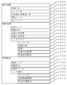
- 1 Information sharing system, 10 ... Platform server, 20 ... Database group, 21 ... Map database, 22 ... User database, 23 ... Mobile database, 30 ... User terminal, 40 ... Business server, 11 ... Communication department, 12 ... Search unit, 13 ... Generation unit, 231 to 233 ... Movement data
Landscapes
- Engineering & Computer Science (AREA)
- Radar, Positioning & Navigation (AREA)
- Remote Sensing (AREA)
- Physics & Mathematics (AREA)
- General Physics & Mathematics (AREA)
- Business, Economics & Management (AREA)
- Theoretical Computer Science (AREA)
- Automation & Control Theory (AREA)
- Educational Technology (AREA)
- Marketing (AREA)
- Mathematical Physics (AREA)
- Health & Medical Sciences (AREA)
- Economics (AREA)
- General Health & Medical Sciences (AREA)
- Human Resources & Organizations (AREA)
- Educational Administration (AREA)
- Primary Health Care (AREA)
- Strategic Management (AREA)
- Tourism & Hospitality (AREA)
- General Business, Economics & Management (AREA)
- Navigation (AREA)
- Instructional Devices (AREA)
- Management, Administration, Business Operations System, And Electronic Commerce (AREA)
Priority Applications (1)
| Application Number | Priority Date | Filing Date | Title |
|---|---|---|---|
| JP2021529957A JPWO2021002218A1 (https=) | 2019-07-01 | 2020-06-19 |
Applications Claiming Priority (2)
| Application Number | Priority Date | Filing Date | Title |
|---|---|---|---|
| JP2019-122676 | 2019-07-01 | ||
| JP2019122676 | 2019-07-01 |
Publications (1)
| Publication Number | Publication Date |
|---|---|
| WO2021002218A1 true WO2021002218A1 (ja) | 2021-01-07 |
Family
ID=74100341
Family Applications (1)
| Application Number | Title | Priority Date | Filing Date |
|---|---|---|---|
| PCT/JP2020/024063 Ceased WO2021002218A1 (ja) | 2019-07-01 | 2020-06-19 | コンピュータシステムおよび記憶媒体並びにプログラム |
Country Status (2)
| Country | Link |
|---|---|
| JP (2) | JP7397713B2 (https=) |
| WO (1) | WO2021002218A1 (https=) |
Families Citing this family (4)
| Publication number | Priority date | Publication date | Assignee | Title |
|---|---|---|---|---|
| JP7431779B2 (ja) * | 2021-07-19 | 2024-02-15 | Lineヤフー株式会社 | 情報処理装置、情報処理方法、およびプログラム |
| JP7618526B2 (ja) * | 2021-09-27 | 2025-01-21 | 本田技研工業株式会社 | マルチモーダル輸送システム、マルチモーダル輸送方法およびプログラム |
| WO2023053475A1 (ja) * | 2021-09-28 | 2023-04-06 | 日本電気株式会社 | 移動経路情報提供システム、介助プラットフォームシステム、移動経路情報提供方法、およびコンピュータ読み取り可能な記憶媒体 |
| WO2023053474A1 (ja) * | 2021-09-28 | 2023-04-06 | 日本電気株式会社 | 介助要員手配システム、介助プラットフォームシステム、介助要員手配方法、およびコンピュータ読み取り可能な記憶媒体 |
Citations (3)
| Publication number | Priority date | Publication date | Assignee | Title |
|---|---|---|---|---|
| JP2000046576A (ja) * | 1998-07-29 | 2000-02-18 | Nec Corp | 移動体誘導装置及びその方法並びにプログラムを記録した機械読み取り可能な記録媒体 |
| JP2003214870A (ja) * | 2002-01-23 | 2003-07-30 | Mazda Motor Corp | ナビゲーション方法及び装置、並びにそのコンピュータ・プログラム |
| JP2015010889A (ja) * | 2013-06-27 | 2015-01-19 | 株式会社コスモルート | 判断プログラム、判断サーバ、及び、判断システム |
Family Cites Families (4)
| Publication number | Priority date | Publication date | Assignee | Title |
|---|---|---|---|---|
| JP2001093088A (ja) | 1999-09-21 | 2001-04-06 | Hitachi Eng Co Ltd | 輸送運行管理システム |
| JP4754444B2 (ja) | 2006-09-05 | 2011-08-24 | パナソニック株式会社 | 走行軌跡管理システム |
| JP2009298541A (ja) | 2008-06-12 | 2009-12-24 | Pasuko:Kk | ルート決定支援装置及びルート決定支援プログラム |
| JP6237801B2 (ja) | 2016-02-22 | 2017-11-29 | 富士通株式会社 | 運行支援プログラム、運行支援方法および運行支援装置 |
-
2020
- 2020-02-21 JP JP2020028239A patent/JP7397713B2/ja active Active
- 2020-06-19 JP JP2021529957A patent/JPWO2021002218A1/ja active Pending
- 2020-06-19 WO PCT/JP2020/024063 patent/WO2021002218A1/ja not_active Ceased
Patent Citations (3)
| Publication number | Priority date | Publication date | Assignee | Title |
|---|---|---|---|---|
| JP2000046576A (ja) * | 1998-07-29 | 2000-02-18 | Nec Corp | 移動体誘導装置及びその方法並びにプログラムを記録した機械読み取り可能な記録媒体 |
| JP2003214870A (ja) * | 2002-01-23 | 2003-07-30 | Mazda Motor Corp | ナビゲーション方法及び装置、並びにそのコンピュータ・プログラム |
| JP2015010889A (ja) * | 2013-06-27 | 2015-01-19 | 株式会社コスモルート | 判断プログラム、判断サーバ、及び、判断システム |
Also Published As
| Publication number | Publication date |
|---|---|
| JP2021009675A (ja) | 2021-01-28 |
| JPWO2021002218A1 (https=) | 2021-01-07 |
| JP7397713B2 (ja) | 2023-12-13 |
Similar Documents
| Publication | Publication Date | Title |
|---|---|---|
| Basu et al. | Sustainable mobility in auto-dominated Metro Boston: Challenges and opportunities post-COVID-19 | |
| Braca et al. | A computerized approach to the New York Cityschool bus routing problem | |
| JP7609566B2 (ja) | コンピュータシステム | |
| WO2021002218A1 (ja) | コンピュータシステムおよび記憶媒体並びにプログラム | |
| JP6666507B1 (ja) | コンピュータシステム、およびプログラム | |
| JP7201394B2 (ja) | 情報提供装置、情報提供システム、情報提供方法、情報提供プログラム | |
| Chiu et al. | A multi-modal agent based mobile route advisory system for public transport network | |
| CN111121798B (zh) | 数据生成装置及系统、数据生成方法、数据生成程序 | |
| JP7537983B2 (ja) | サーバ装置、処理方法、およびプログラム | |
| JP2006099674A (ja) | 通勤経路演算システム及び演算方法 | |
| Nakashima et al. | One cycle of smart access vehicle service development | |
| JP2021009680A (ja) | コンピュータシステムおよびプログラム | |
| Vanderwaart | Planning transit networks with origin, destination, and interchange inference | |
| Saintika et al. | Readiness of Operating Bus Rapid Transit (BRT) Purwokerto-Purbalingga towards Smart City Concept | |
| JP2021009679A (ja) | コンピュータシステムおよびプログラム | |
| Simchi-Levi et al. | A case study: School bus routing | |
| JP2007207077A (ja) | 配車情報提供システム及び配車予約サーバ | |
| JP2022037968A (ja) | 端末、データ構造、およびプログラム | |
| JP2021185360A (ja) | コンピュータシステムおよびプログラム | |
| JP2021189818A (ja) | コンピュータシステムおよびプログラム | |
| Bhatti | ANALYZING THE EFFICIENCY OF METRO BUSES INISLAMABAD. | |
| Ling | An Atlanta-based Analysis on the Feasibility of Employee Commute Options Programs and Switching from Driving Alone to Alternative Commute Modes | |
| JP7573984B2 (ja) | コンピュータシステムおよびプログラム | |
| Belz et al. | Car sharing: A feasibility study in Hong Kong | |
| JP7609604B2 (ja) | コンピュータシステム、プログラム、および方法 |
Legal Events
| Date | Code | Title | Description |
|---|---|---|---|
| 121 | Ep: the epo has been informed by wipo that ep was designated in this application |
Ref document number: 20835162 Country of ref document: EP Kind code of ref document: A1 |
|
| ENP | Entry into the national phase |
Ref document number: 2021529957 Country of ref document: JP Kind code of ref document: A |
|
| NENP | Non-entry into the national phase |
Ref country code: DE |
|
| 122 | Ep: pct application non-entry in european phase |
Ref document number: 20835162 Country of ref document: EP Kind code of ref document: A1 |