WO2021002218A1 - コンピュータシステムおよび記憶媒体並びにプログラム - Google Patents
コンピュータシステムおよび記憶媒体並びにプログラム Download PDFInfo
- Publication number
- WO2021002218A1 WO2021002218A1 PCT/JP2020/024063 JP2020024063W WO2021002218A1 WO 2021002218 A1 WO2021002218 A1 WO 2021002218A1 JP 2020024063 W JP2020024063 W JP 2020024063W WO 2021002218 A1 WO2021002218 A1 WO 2021002218A1
- Authority
- WO
- WIPO (PCT)
- Prior art keywords
- route
- information
- user
- movement
- data
- Prior art date
Links
- 238000003860 storage Methods 0.000 title claims description 14
- 230000033001 locomotion Effects 0.000 description 216
- 238000000034 method Methods 0.000 description 29
- 238000004891 communication Methods 0.000 description 16
- 230000008569 process Effects 0.000 description 16
- 230000006870 function Effects 0.000 description 10
- 238000010586 diagram Methods 0.000 description 9
- 238000004519 manufacturing process Methods 0.000 description 8
- 238000012545 processing Methods 0.000 description 8
- 238000005457 optimization Methods 0.000 description 7
- 238000004458 analytical method Methods 0.000 description 4
- 230000006872 improvement Effects 0.000 description 4
- 230000004888 barrier function Effects 0.000 description 3
- 238000007726 management method Methods 0.000 description 3
- 230000006399 behavior Effects 0.000 description 2
- 238000004364 calculation method Methods 0.000 description 2
- 238000011156 evaluation Methods 0.000 description 2
- 239000000284 extract Substances 0.000 description 2
- 230000004044 response Effects 0.000 description 2
- 239000004065 semiconductor Substances 0.000 description 2
- 238000012546 transfer Methods 0.000 description 2
- 230000005540 biological transmission Effects 0.000 description 1
- 230000008859 change Effects 0.000 description 1
- 238000009826 distribution Methods 0.000 description 1
- 230000000694 effects Effects 0.000 description 1
- 230000007717 exclusion Effects 0.000 description 1
- 230000007246 mechanism Effects 0.000 description 1
- 230000004048 modification Effects 0.000 description 1
- 238000012986 modification Methods 0.000 description 1
- 230000003287 optical effect Effects 0.000 description 1
- 230000035935 pregnancy Effects 0.000 description 1
- 230000009467 reduction Effects 0.000 description 1
- 230000000717 retained effect Effects 0.000 description 1
- 238000004904 shortening Methods 0.000 description 1
- 230000029305 taxis Effects 0.000 description 1
- 238000012795 verification Methods 0.000 description 1
- 238000012800 visualization Methods 0.000 description 1
- XLYOFNOQVPJJNP-UHFFFAOYSA-N water Substances O XLYOFNOQVPJJNP-UHFFFAOYSA-N 0.000 description 1
Images


Classifications
-
- G—PHYSICS
- G01—MEASURING; TESTING
- G01C—MEASURING DISTANCES, LEVELS OR BEARINGS; SURVEYING; NAVIGATION; GYROSCOPIC INSTRUMENTS; PHOTOGRAMMETRY OR VIDEOGRAMMETRY
- G01C21/00—Navigation; Navigational instruments not provided for in groups G01C1/00 - G01C19/00
- G01C21/26—Navigation; Navigational instruments not provided for in groups G01C1/00 - G01C19/00 specially adapted for navigation in a road network
- G01C21/34—Route searching; Route guidance
-
- G—PHYSICS
- G06—COMPUTING; CALCULATING OR COUNTING
- G06Q—INFORMATION AND COMMUNICATION TECHNOLOGY [ICT] SPECIALLY ADAPTED FOR ADMINISTRATIVE, COMMERCIAL, FINANCIAL, MANAGERIAL OR SUPERVISORY PURPOSES; SYSTEMS OR METHODS SPECIALLY ADAPTED FOR ADMINISTRATIVE, COMMERCIAL, FINANCIAL, MANAGERIAL OR SUPERVISORY PURPOSES, NOT OTHERWISE PROVIDED FOR
- G06Q50/00—Information and communication technology [ICT] specially adapted for implementation of business processes of specific business sectors, e.g. utilities or tourism
- G06Q50/40—Business processes related to the transportation industry
-
- G—PHYSICS
- G08—SIGNALLING
- G08G—TRAFFIC CONTROL SYSTEMS
- G08G1/00—Traffic control systems for road vehicles
- G08G1/005—Traffic control systems for road vehicles including pedestrian guidance indicator
-
- G—PHYSICS
- G09—EDUCATION; CRYPTOGRAPHY; DISPLAY; ADVERTISING; SEALS
- G09B—EDUCATIONAL OR DEMONSTRATION APPLIANCES; APPLIANCES FOR TEACHING, OR COMMUNICATING WITH, THE BLIND, DEAF OR MUTE; MODELS; PLANETARIA; GLOBES; MAPS; DIAGRAMS
- G09B29/00—Maps; Plans; Charts; Diagrams, e.g. route diagram
- G09B29/10—Map spot or coordinate position indicators; Map reading aids
Definitions
- One aspect of this disclosure relates to computer systems and / or programs.
- Patent Document 1 a technique for providing a user with a movement route from a starting point to a destination has been known (see, for example, Patent Document 1).
- One aspect of this disclosure is to properly manage the travel route from the starting point to the destination.
- the route information associated with at least one piece of information on the candidate route searched as a candidate is made available to the business operator.
- FIG. 1 It is a figure which shows an example of application of the information sharing system which concerns on embodiment. It is a figure which shows an example of the hardware configuration of the platformer server which concerns on embodiment. It is a figure which shows the example of the data structure of the movement data. It is a figure which shows the example of the data structure of the movement data. It is a figure which shows the example of the data structure of the movement data. It is a figure which shows an example of the functional structure of the platformer server which concerns on embodiment. It is a flowchart which shows an example of the operation of the information sharing system which concerns on embodiment. It is a figure which shows an example of the result of a route search. It is a figure which shows an example of the movement data corresponding to the search result shown in FIG.
- the information sharing system 1 is a computer system that searches for a movement route from a departure point to a destination designated by the user and provides the movement route to the user.
- the user is a person who obtains a movement route by using the information sharing system 1.
- the user may be an individual or a group of multiple people.
- the departure point is a place set as a start point for searching a travel route
- a destination is a place set as an end point for the search. Both the starting point and the destination are reference points for route search.
- the movement route is information about movement from one point to another.
- the movement route can indicate not only the route from the starting point to the destination but also the attribute of the route (hereinafter referred to as "route attribute").
- route attribute is arbitrary information that represents the nature, characteristics, or situation of a route.
- route attributes include transportation means such as transportation, the time or cost required to travel the route, the status of the route (for example, traffic information), and the features related to the route (that is, feature information). It may include at least one of a business operator related to the route (that is, business information) and service information related to the route (for example, advertising information, coupon information, etc.).
- a feature is any tangible or intangible object that exists on the ground.
- the feature may be a natural object or an artificial object.
- features can include mountains, farmlands, residential areas, vacant lots, rivers, lakes, seas, tourist destinations, roads, railroads, buildings, parks, towers, traffic lights, railroad crossings, pedestrian crossings, pedestrian bridges, floats, and the like.
- intangible features include areas set for arbitrary purposes (eg, photography prohibited areas, temporary exclusion zones, etc.), areas where events are held, meeting places, shooting spots, and the like. ..
- the types of features are not limited to these.
- the information sharing system 1 plays a role of comprehensively controlling or managing information related to the movement of people.
- the information sharing system 1 searches for one or more suitable travel routes from options including various modes of transportation or means of transportation and provides the travel routes to the user.
- the information sharing system 1 generates movement data including a combination of a user and a movement route and a movement ID which is an identifier corresponding to this combination, and stores the movement data in a given database. This movement data can be used for various purposes.
- the information sharing system 1 serves as a movement route that can be provided or used between various users and various businesses, or a platform that comprehensively controls or manages various information related to the movement route. Can be fulfilled.
- the administrator or operator of the information sharing system 1 can be a platformer.
- the information sharing system 1 can provide the movement data to any number of businesses that provide any service related to movement.
- the operator can provide the service or information to the user based on the movement data, and the user can obtain the service or information.
- the information sharing system 1 can provide the user with various information such as traffic information, advertisements, coupons, and facility information based on the movement data.
- the operator can perform various statistics or analyzes based on the travel data and perform various processes such as proposals, evaluations, and plans based on the results obtained.
- the business operators related to the information sharing system 1 are not limited. Examples of businesses include various transportation businesses such as railroads, buses, taxis, planes, and ships, rental businesses for various means of transportation such as automobiles and bicycles, vehicle dispatch service businesses, and shopping. Examples include businesses that operate various facilities such as restaurants and parking lots, businesses that provide various information such as advertisements and coupons, payment businesses, and various organizations of the national or local governments.
- the service or information provided to the user is also not limited.
- Examples of services or information include route guidance, timetables, reservations, rentals, vehicle allocation, facility information, advertisements, payments, coupons, real estate information, statistical information, marketing information.
- the information sharing system 1 can be used for MaaS, that is, "mobility as a service”. However, the use of the information sharing system 1 is not limited to this, and the information sharing system 1 can be used for various purposes.
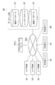
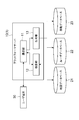
- FIG. 1 is a diagram showing an example of application of the information sharing system 1.
- the information sharing system 1 includes a platformer server 10 which is a computer that provides a movement route to a user.
- the platform server 10 connects to the database group 20, one or more user terminals 30, and one or more operator servers 40 via the communication network NW.
- the platform server 10 is a computer that executes the main functions of the information sharing system 1.
- the computer that functions as the platform server 10 is not limited.
- the platform server 10 is composed of a large computer such as a business server.
- FIG. 2 shows an example of the hardware configuration of the platform server 10.
- the platform server 10 has a control circuit 100.
- the control circuit 100 has one or more processors 101, a memory 102, a storage 103, a communication port 104, and an input / output port 105.
- Processor 101 executes the operating system and application programs.
- the storage 103 is composed of a hard disk, a non-volatile semiconductor memory, or a storage medium of a retrievable medium (for example, a magnetic disk, an optical disk, etc.) and stores an operating system and an application program.
- the memory 102 temporarily stores the program loaded from the storage 103 or the calculation result by the processor 101.
- the processor 101 functions as each of the above functional modules by executing a program in cooperation with the memory 102.
- the communication port 104 performs data communication with another device via the communication network NW in accordance with a command from the processor 101.
- the input / output port 105 executes input / output of an electric signal to / from an input / output device (user interface) such as a keyboard, a mouse, and a monitor according to a command from the processor 101.
- the platform server 10 may be composed of one or more computers. When a plurality of computers are used, one platformer server 10 is logically configured by connecting these computers to each other via a communication network.
- the database group 20 is a set of databases that store necessary data in the information sharing system 1.
- the database group 20 includes a map database 21, a user database 22, and a mobile database 23.
- Each database may be constructed as a part of the information sharing system 1, or may be provided in a computer system different from the information sharing system 1.
- the platform server 10 can access individual databases to read and write data.
- the map database 21 is a non-temporary storage medium or storage device that permanently stores map data indicating map elements constituting the map.
- map elements include nodes and links.
- a node is a position set to control the movement of a moving body, and more specifically, a position where a moving method (for example, direction, speed, etc.) of the moving body can be changed. ..
- At least some of the nodes can be transportation hubs.
- a transportation hub is a place where multiple modes of transportation of the same type or different types are connected.
- a link is a virtual line set to indicate a route and connects adjacent nodes. The shape of the link may be a straight line or a curved line, or may be a combination of a straight line and a curved line.
- the shape of the link can depend on the shape of the road.
- the location where nodes and links are set is not limited, for example, nodes and links can be set above ground, underground, in the air, above water, or underwater. There may be multiple links connecting the two nodes. For example, two nodes may be connected by both a railroad link and a road link.
- the map data may be configured to include node data indicating a plurality of nodes and link data indicating a plurality of links.
- node data includes node IDs, coordinates, and node attributes as data items.
- the node ID is an identifier that uniquely identifies each node.
- the coordinates are values that indicate the two-dimensional or three-dimensional geographical position of the node. The method of setting the coordinates is not limited, and for example, the coordinates may be expressed using latitude and longitude, or may be set according to any other coordinate system.
- a node attribute is arbitrary information that represents the nature, characteristics, or status of a node.
- the node attribute may include a nodal flag, which is a binary indicating whether or not the node is a transportation hub.
- the node attribute may include feature information about the feature related to the node, or may include the operator information about the operator related to the node.
- the link data includes a link ID, a first node ID, a second node ID, and a link attribute as data items.
- the link ID is an identifier that uniquely identifies each link. Both the first node ID and the second node ID are node IDs that identify the node located at the end of the link.
- Link attributes are arbitrary information that describes the nature, characteristics, or circumstances of a link. For example, link attributes include transportation means such as transportation, the time or cost required to move the link, the status of the link (eg traffic information), and the features related to the link (ie feature information). It may include at least one of the business operator related to the link (that is, business information) and the service information related to the link (for example, advertising information, coupon information, etc.).
- the user database 22 is a non-temporary storage medium or storage device that permanently stores user data related to the user.
- user data includes user IDs and user attributes as data items.
- the user ID is an identifier that uniquely identifies each user.
- User attributes are arbitrary information that represents the nature, characteristics, or circumstances of the user.
- the user attribute may include various information such as name, gender, age, means of transportation possessed, and barrier information.
- Barrier information refers to matters that should or should be considered when the user moves.
- the barrier information may indicate matters such as the necessity of a wheelchair, pregnancy, and old age.
- the mobile database 23 is a non-temporary storage medium or storage device that permanently stores mobile data.
- travel data includes travel IDs, user IDs, and at least one travel path as data items.
- the method of setting the movement ID is not limited.
- one identifier may be set as the movement ID corresponding to the combination of the user ID and one or more movement routes extracted in one search process.
- one unique movement ID is set for the combination of the user ID and the set of one or more movement routes.
- a user ID and a movement ID that uniquely identifies the combination of the movement routes may be set for each of the one or more movement routes extracted in one search process. In this case, one unique movement ID is set for the combination of the user ID and one movement route.
- the data structure of the movement data may be designed according to any policy.
- the information sharing system 1 may generate movement data indicating a movement route by using a plurality of node IDs and a plurality of link IDs.
- the node ID and the link ID constituting the movement route may be only the node ID of the specific node and the link ID of the link connecting the specific nodes.
- the particular node may be a node of a transportation hub.
- the information sharing system 1 may generate movement data including route attributes.
- a route attribute is arbitrary information that represents the nature, characteristics, or situation of a route.
- the route attribute may indicate whether the travel route is searched as a candidate, selected by the user, or actually used by the user.
- the movement route searched as a candidate is referred to as a "candidate route”
- the movement route selected by the user is referred to as a "planned route”
- the movement route actually used by the user is referred to as a "actual route”. ..
- a movement route selected and used by a user as one movement route is also referred to as a "planned / actual route”.
- the route attribute indicates at least one of the route searched as a candidate, the route selected by the user, and the route actually used by the user.
- FIGS. 3 to 5 are diagrams showing an example of the data structure of the moving data.
- one unique movement ID "M1001" is assigned to the plurality of searched movement routes.
- the movement data 232 shown in FIG. 4 one unique movement ID is assigned to each of the three searched movement routes.
- movement data 232a, 232b, and 232c corresponding to the three movement paths are generated, and the movement IDs of these movement data are set to "M1001", "M1002", and "M1003", respectively.
- the information sharing system 1 may generate movement data for each of the searched one or more movement routes.
- a unique movement ID "M1001" is assigned only to the movement route selected or used by the user among the one or more searched movement routes.
- the information sharing system 1 does not generate movement data for the movement routes not selected by the user among the one or more searched movement routes, and the information sharing system 1 of the searched one or more movement routes.
- movement data may be generated for the movement route selected or used by the user.
- the moving data may have any other data structure.
- the computer can refer to the user data corresponding to the user ID and the node data and the link data corresponding to the individual nodes and individual links constituting the movement route.
- the computer can identify the user ID associated with the mobile ID by referring to the mobile ID, and can refer to the user attribute (that is, the user's attribute information) associated with the user ID. it can.
- the computer can identify the node ID associated with the mobile ID by referring to the mobile ID, and can refer to the node attribute (that is, the attribute information of the node) associated with the node ID.
- the computer can identify the link ID associated with the mobile ID and refer to the link attribute (that is, the attribute information of the link) associated with the link ID.
- the computer can access the map database 21 and the user database 22 based on these IDs to acquire various attribute information.
- the movement data may include at least one of at least some user attributes, at least some node attributes, and at least some link attributes. This means that at least a part of the attribute information is denormalized and retained in the database group 20.
- Individual data items of individual data may be set statically or dynamically.
- Statically set means that the value is preset and the setting is not changed unless there is manual intervention.
- dynamically set means that the value can be changed according to an arbitrary event without manual intervention. Dynamic configuration is achieved by running a program that controls a given data item on a given computer. The dynamic settings may be performed by the information sharing system 1 or by another computer system.
- the structure of individual data is not limited, and the data structure may be designed according to any policy.
- at least one of map data, user data, and movement data may be normalized or denormalized by an arbitrary policy and stored on one or more data tables.
- map data, user data, and movement data are shared among multiple operators. Therefore, each business operator can efficiently obtain information on the movement of the user from the information sharing system 1 and use the information.
- the operator can provide various services or information related to the movement of the user, or process the information related to the movement of the user by an arbitrary method.
- the platformer can provide a user with a cross-sectional service or information across multiple transportation operators, and the user can enjoy the service or information.
- at least a part of the information about each of the node attribute and the link attribute which can save the number of databases and the data capacity in the entire information sharing system 1, is provided by the operator. It may be provided, for example, from the database of an individual operator. Alternatively, the databases of the individual operators may play at least part of the role of the map database 21.
- the user terminal 30 is a computer operated by the user.
- the user terminal 30 may be a fixed terminal or a mobile terminal. Examples of the user terminal 30 include mobile phones, smartphones, tablet terminals, wearable terminals, and personal computers, but the types of terminals are not limited thereto.
- the number of user terminals 30 that access the information sharing system 1 is not limited.
- the business server 40 is a computer managed or operated by the business.
- the computer that functions as the operator server 40 is not limited.
- the business server 40 may be configured by a large computer such as a business server, or may be configured by a personal computer.
- the number of business server 40s that access the information sharing system 1 is not limited.
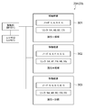
- FIG. 6 is a diagram showing an example of the functional configuration of the platform server 10.
- the platform server 10 includes a communication unit 11, a search unit 12, and a generation unit 13 as functional modules.
- the communication unit 11 is a functional module that transmits / receives data to / from another computer.
- the search unit 12 is a function module for searching a movement route.
- the generation unit 13 is a functional module that generates and stores movement data.
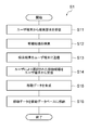
- FIG. 7 is a flowchart showing an example of the operation of the information sharing system 1 as a processing flow S1.
- step S11 the communication unit 11 receives the search condition from the user terminal 30.
- the user operates the user terminal 30, inputs information necessary for route search, and instructs transmission of the information.
- the user terminal 30 generates a search condition in response to the operation, and transmits the search condition to the platform server 10.
- the communication unit 11 receives the search condition.
- the search condition is a data signal indicating at least a starting point and a destination specified by the user.
- the search condition may further include other data items such as at least one of the departure date and time and the arrival date and time, at least one waypoint.
- the search condition may include a data item relating to the user, for example, may include a user ID, or may further include at least one data item relating to the user attribute.
- the search unit 12 searches for a movement route that satisfies the search condition.
- the search unit 12 extracts the movement route by searching the map data in the map database 21 based on the search conditions.
- the search condition includes data items related to the user
- the search unit 12 may refer to the user data in the user database 22 in addition to the map database 21.
- the search unit 12 may search for a plurality of movement routes, for example, a plurality of movement routes having different routes, a plurality of movement routes having the same route but different transportation means or travel dates and times, or both of these movement routes. You may search for.
- the search unit 12 can extract a plurality of movement routes corresponding to various movement methods provided by various businesses. That is, the search unit 12 can collectively search a plurality of movement routes in the form of crossing a plurality of transportation companies, which can be said to be an example of MaaS.
- step S13 the communication unit 11 transmits the search result to the user terminal 30.
- the search result is a data signal indicating one or more searched movement routes.
- the user terminal 30 receives and displays the search result, whereby the user can confirm the search result.
- step S14 the communication unit 11 receives the movement route selected by the user from the user terminal 30.
- the user operates the user terminal 30 to select a desired movement route.
- the user terminal 30 transmits information indicating the selected movement route to the platform server 10.
- the communication unit 11 receives the information.
- step S15 the generation unit 13 generates movement data.
- the generation unit 13 generates movement data including a combination of the user and the selected movement route and a movement ID corresponding to this combination.
- the data structure of the moving data is not limited, so that the specific method of generating the moving data is not limited.
- the generation unit 13 generates movement data by associating the user ID, the movement route selected by the user, and the movement ID with each other.
- the generation unit 13 may set a route attribute so as to indicate that the movement route is a planned route.
- the generation unit 13 may generate movement data indicating a movement route presented to the user as a candidate but not selected by the user.
- the generation unit 13 can specify the movement route by acquiring the search result from the search unit 12.
- the generation unit 13 generates movement data by associating a user ID, a plurality of movement routes corresponding to search results, and one movement ID with each other.
- the generation unit 13 sets the route attributes of a plurality of movement routes. Specifically, the generation unit 13 may set the route attribute of the movement route selected by the user to "plan" and the route attribute of the movement route not selected by the user to "candidate".
- the generation unit 13 may generate movement data for each of the plurality of movement routes corresponding to the search results.
- the generation unit 13 generates movement data by associating the user ID, the movement route, and the movement ID with each other for each of the plurality of movement routes.
- the generation unit 13 sets the route attribute for each movement route. Specifically, the generation unit 13 indicates that the movement route selected by the user is a planned route, and indicates that the route not selected by the user is a candidate route in each movement data. Set attributes.
- step S16 the generation unit 13 stores the movement data in the movement database 23.
- the movement data can be shared by a plurality of businesses.
- FIG. 8 is a diagram showing an example of the result of the route search.
- FIG. 9 is a diagram showing an example of moving data corresponding to the search result.
- the search unit 12 passes through the movement routes 301 that sequentially pass through the nodes A, B, and E and the nodes A, F, H, and D as the movement routes from the departure point S to the destination G. It is assumed that the moving route 302 to be used and the moving route 303 passing through the nodes A, B, C, and D in order are extracted. After that, it is assumed that the user having the user ID "U2101" selects the movement route 303.
- the generation unit 13 may generate the movement data 234 shown in FIG. 9, for example.
- the movement ID "M1101" of the movement data 234 corresponds to the combination of the user ID and the movement route 301, the combination of the user ID and the movement route 302, and the combination of the user ID and the movement route 303. Since the user has selected the movement route 303, the generation unit 13 sets the route attribute of the movement route 303 to "plan” and sets the route attributes of the movement routes 301 and 302 to "candidates".
- FIG. 10 is a diagram showing an example of route search.
- the information sharing system 1 can collectively search a plurality of travel routes in the form of crossing a plurality of transportation companies.
- the information sharing system 1 has a transportation means 61 provided by the business operator P, a transportation means 62 provided by the business operator Q, and a business operator as a movement route from the departure point S to the destination G.
- the search result based on the combination with the transportation means 63 provided by R is provided.
- the user 51 can select a desired movement route from this search result.
- FIG. 11 is a diagram showing an example of using the movement route selected by the user 52.
- the user 52 is a person using a wheelchair.
- the user 52 can use the user terminal 30 to obtain various service information regarding the route to be followed, such as traffic information, information on surrounding facilities, weather forecast, advertisement, coupon, and the like.
- the user 52 can also make various reservations, such as seat reservations and assistant assistants, using the user terminal 30.
- each business operator can grasp in advance what kind of person will use the transportation system and take necessary measures.
- the operators P and R corresponding to the means of transportation 61 and 63 can each have staff to assist in getting on and off for the user 52 who moves in a wheelchair.
- FIG. 12 is a diagram showing an example of payment regarding the movement route used by the user 53.
- the movement data stored in the movement database 23 enables various processing.
- the movement data contributes to visualization of various events related to the movement of people. Below are various examples of the use of mobile data.
- the travel route may include information about the parking lot, for example, parking lot location, availability, or fees.
- the travel route may include information or suggestions regarding carpooling.
- Examples of service information provided to users regarding selected travel routes include advertisements or coupons for transportation or facilities, optimal boarding location guidance for transfers, detour guidance for the same amount, and alternative transportation options.
- Reservations related to the selected travel route can also be realized. Examples of such reservations include reservations for transportation seats, parking lots, use of various facilities, assistants, and the like.
- Payments related to the selected travel route may also be realized. Examples of such payments include payment of the difference from the commuter pass, automatic payment without using a ticket gate, payment by splitting the bill, proposal of discounts, and automation of corporate transportation expense settlement.
- the accumulated movement data may be used for various statistics or analysis.
- travel data includes congestion calculation, new route proposals, demand forecasts, verification of differences between selected and unselected routes, marketing or advertising proposals, real estate price valuation or determination, It can be used for city planning or transportation planning, facility evaluation, waiting time prediction, traffic analysis, inventory optimization, transportation timetable optimization, guidance optimization by signage, etc.
- the program for making the computer function as the platform server 10 includes a program code for making the computer function as a communication unit 11, a search unit 12, and a generation unit 13.
- This program may be provided after being fixedly recorded on a non-temporary recording medium such as a CD-ROM, a DVD-ROM, or a semiconductor memory. Alternatively, the program may be provided via a communication network as a data signal superimposed on a carrier wave.
- the provided program is stored in the storage 103, and each of the above functional modules is realized by the processor 101 executing the program in cooperation with the memory 102.
- the computer system includes at least one processor.
- At least one processor refers to a map database that stores map data shared among a plurality of operators, and one or more movements corresponding to a search condition indicating at least a starting point and a destination specified by a user.
- a route is searched, and for each of at least one of the searched one or more movement routes, movement data in which the user and the combination of the movement routes and the movement ID corresponding to the combination are associated with each other is generated. Then, the movement data is stored in the movement database so that the generated movement data can be shared by a plurality of businesses.
- the program according to one aspect of the present disclosure refers to a map database that stores map data shared among a plurality of businesses, and corresponds to a search condition indicating at least a starting point and a destination specified by a user. For each of the step of searching for one or more movement routes and at least one of the searched movement routes, the combination of the user and the movement route and the movement ID corresponding to the combination are associated with each other.
- the computer is made to perform a step of generating the generated movement data and a step of storing the movement data in the movement database so that the generated movement data can be shared by a plurality of businesses.
- the movement data in which the movement ID is associated with the combination of the user and the movement route is registered in the database. Since the individual correspondence between the user and the movement route can be grasped from this movement data, it becomes possible to appropriately manage the movement route from the departure point to the destination.
- the mobile ID may be an identifier that uniquely identifies the combination.
- the individual correspondence between the user and the movement route can be identified using only the movement ID.
- At least one processor may generate movement data for each of one or more searched movement paths.
- the correspondence with the user can be managed by using the movement ID for all the searched movement routes regardless of whether or not they are selected by the user.
- At least one processor searches for one or more travel paths without generating travel data for travel routes that are not selected by the user among one or more searched travel routes.
- movement data may be generated for the movement route selected or used by the user.
- At least one processor may generate movement data indicating a movement route by a plurality of node IDs and a plurality of link IDs.
- the node ID is an identifier that uniquely identifies the node that constitutes the map, and is associated with the attribute information of the node.
- the link ID is an identifier that uniquely identifies a link connecting adjacent nodes, and is associated with the attribute information of the link.
- the node may be a transportation hub.
- the nodes By limiting the nodes to traffic nodes, which are important places in the movement route, the characteristics of each movement route can be accurately expressed by the movement data.
- the number of node IDs used to represent the movement route is suppressed, the data size of individual movement data can be suppressed.
- At least one processor indicates a route attribute indicating at least one of a route searched as a candidate, a route selected by the user, and a route actually used by the user. You may generate movement data including. By embedding such a route attribute in the movement data, the relationship between the user and the movement route can be specified from the movement data.
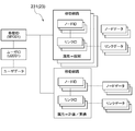
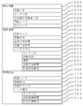
- FIG. 13 is a diagram showing another example of the data structure of the movement data.
- Reference numeral 500 denotes basic information, which includes the information described below.
- Reference numeral 510 is a movement ID, which is management information for uniquely identifying the information obtained by the combination of the basic information 500, the planned route information 600, and the actual route information 700.
- Reference numeral 520 is a user ID, which is an identifier that uniquely identifies the user. This user ID may be anonymized or encrypted so that an individual cannot be identified when associated with other data items. By doing so, the business operator can obtain information on the movement of the user as information on the destination of the user in a form that does not identify an individual, and data distribution that meets the request for protection of personal information becomes possible.
- 530 is the route issuer ID.
- the ID represents an administrator or an operator of an information sharing system 1 that performs processing for generating moving data, such as a platformer.
- Reference numeral 540 is information on the starting node as the starting point of the moving path represented by the moving ID.
- Reference numeral 550 is information on the end node as the end point of the movement path represented by the movement ID.
- Reference numeral 600 denotes planned route information, that is, information representing the planned route, and includes information described below.
- Reference numeral 610 is a route code, which is management information for uniquely identifying the planned route.
- Reference numeral 620 is information on the means of transportation, and represents the means of transportation (including walking, the same shall apply hereinafter) used when the user moves along the planned route.
- the plurality of transportation means are stored.
- 630 is information on the scheduled departure time, which is the scheduled time when the user starts moving along the planned route.
- 640 is information on the estimated arrival time, which is the scheduled time when the user finishes the movement along the planned route.
- Reference numeral 650 is a link list, which is information representing individual links constituting the planned route and how to connect the links, and includes information described below.
- Reference numeral 651 is a link ID, which is an identifier that uniquely identifies each link constituting the planned route.
- Reference numeral 652 is information on the means of transportation, which is information on the means of transportation in which the user moves on individual links constituting the movement route.
- 653 is the fare information, which indicates that there is a charge for passing the link and / or the charge.
- 654 is information on the scheduled departure time of the link, which is the scheduled time to move from the starting point of a specific link.
- 655 is information on the estimated arrival time of the link, which is the estimated time to arrive at the end point of a specific link.
- Reference numeral 700 denotes actual route information, that is, information representing the actual route used by the user, and includes information described below.
- Reference numeral 710 is a route code, which is management information for uniquely identifying the actual route. Here, a route followed by the user is described even if the route is different from the planned route.
- Reference numeral 720 is information on the movement status, and passes through the end point of the link after passing the start point of a specific link when the user actually moves, such as the remaining distance of the link and the means of transportation when passing through the link. Represents the movement status to.
- Reference numeral 730 is information on the link during the stay, and represents a link in which the user's current location is associated with the map matching or the like.
- Reference numeral 740 is link information, which includes information described below. 741 is a link ID, which is an identifier that identifies individual links constituting the actual route.
- Reference numeral 742 is information on the actual departure time, and represents the time when the user starts to move on a specific link.
- Reference numeral 743 is information on the actual arrival time, and represents the time when the user finishes moving the specific link.
- the basic information 500, the planned route information 600, and the actual route information 700 are associated with each other.
- the above movement data is generated in the platform server 10 of FIG. 1 and is shared among business operators who are the users of the information sharing system 1 before the start of movement of the user.
- the user determines the planned route from the candidate routes.
- the platform server 10 generates movement data including basic information 500, planned route information 600, and actual route information 700 that associate the movement ID 510 (corresponding to the route information) with the user ID 520 and the like.
- the platform server 10 grasps the history of the position information of the current location of the user terminal 30 according to the movement of the user.
- the platform server 10 generates the movement status 720, the information of the staying link 730 and the link information 740 according to the history, and stores them in the movement database 23. That is, when the location information of the current location and the link of the map database 21 are map-matched, the generation of the actual route data is started and accumulated in the mobile database 23.
- the accumulated actual route data is shared between businesses as follows.
- the accumulated movement data is used as data for collating the planned route or candidate route with the actual route, or as data for only the actual route, as part of the efforts of cooperation between business operators in maintaining and operating the information sharing system 1.
- Information can be shared and used as big data on user behavior.
- the information on the actual route is used as data for determining the place and staying time of the user during the allowable transfer time at a predetermined charge while the user switches the means of transportation. sell. That is, it can be used as data for estimating the consumption behavior of the user in the vicinity of a transportation hub such as Ekinaka or Ekichika.
- the mobile data is shared with the business server 40 and is used as follows. Movement data (basic information 500, planned route information 600, and actual route information 700, or information that associates information on the actual route that is the route that the user has traveled with information on the planned route that is planned for the user to travel.
- the planned route information 600 and the actual route information 700) are shared with the operator server 40.
- the operator server 40 compares the actual route information 700, which is the actual route that the user has moved, with the planned route information 600, which is the information of the planned route planned for the user to move. , The actual route specified from the actual route information 700 is corrected.
- a part of the actual route indicates the first route by the normal map matching process
- there is a second route running in parallel with the route and a part of the planned route is the second route.
- perform the following processing If it is determined that the second route is appropriate in consideration of the entire route of the actual route and the second route of the planned route, the first route of the actual route is changed to the second route. Further, the operator server 40 identifies the difference between the actual route and the planned route by comparing the actual route information 700 and the planned route information 600, and analyzes the cause of the difference.
- the operator server 40 calculates the degree of congestion, proposes a new route, forecasts demand, proposes marketing or advertising, evaluates or determines real estate prices, city planning or transportation planning, and evaluates facilities. , Prediction of waiting time, analysis of traffic flow, optimization of inventory, optimization of timetable of transportation, optimization of guidance by signage, etc. Differences are differences in transportation means (in the planned route, a certain section is a bus, but in the actual route, a certain section is a taxi, etc.), and the difference in the route (the planned route and the actual route are different from a certain point to a certain point. There are differences in the time it takes to cross a certain link, etc.).
- the platform server 10 may share the movement data including the planned route information 600 and the actual route information 700 in which the basic information 500 is separated from the business server 40. This is effective when the business server 40 does not need information on a specific user or attributes of the user when performing analysis. Since the planned route information 600 has the route code 610 and is uniquely specified, and the actual route information 700 has the route code 710 and is uniquely specified, the operator server 40 has appropriate information. Can be identified and analyzed.
- the business server 40 can provide information (advertisement, advertisement, etc.) to a specific user at an appropriate time and place by referring to the user ID of the basic information 500 and the planned route information 600. , To be able to provide services (such as auxiliary services to people in wheelchairs in the above embodiments). Further, in the case of a system in which a plurality of platforms exist one by one in each region and they are linked with each other, the operator server 40 refers to the route issuing operator ID 530 and the operator provides information or services. It is identified through which platform 10 the planned route information of the user is shared. Then, the business operator server 40 performs a transaction with the user (for example, billing of costs for the provided service or the like) via the platformer server 10.
- the user for example, billing of costs for the provided service or the like
- the planned route information 600 may be information on a candidate route instead of the planned route.
- sharing of the mobile data to the business server 40 may be a method of storing the mobile data in the mobile database 23 or a method of providing the mobile data to the business server 40. That is, any mobile data may be available to the business operator.
- each database may be arranged in each of the platformer and the plurality of business operators.
- database synchronization is performed between the platformer and multiple operators, which guarantees the integrity of various data.
- the expression "at least one processor executes the first process, executes the second process, ... executes the nth process", or the expression corresponding thereto is the first.
- the concept including the case where the execution subject (that is, the processor) of n processes from the first process to the nth process changes in the middle is shown. That is, this expression shows a concept including both a case where all n processes are executed by the same processor and a case where the processor changes according to an arbitrary policy in the n processes.
- the processing procedure of the method executed by at least one processor is not limited to the example in the above embodiment. For example, some of the steps (processes) described above may be omitted, or each step may be executed in a different order. In addition, any two or more steps of the above-mentioned steps may be combined, or a part of the steps may be modified or deleted. Alternatively, other steps may be performed in addition to each of the above steps.
- the embodiments described in all or part of the above embodiments include control of movement routes, improvement of processing speed, improvement of processing accuracy, improvement of usability, improvement of functions using data, provision of appropriate functions, and the like.
- Providing appropriate data, programs, recording media, equipment and / or systems such as improving or providing appropriate functions, reducing the capacity of data and / or programs, miniaturizing equipment and / or systems, and data, programs.
- Any one of data, programs, recording media, equipment and / or system production / manufacturing optimization such as reduction of production / manufacturing cost of equipment or system, facilitation of production / manufacturing, shortening of production / manufacturing time, etc. Solve one problem.
- 1 Information sharing system, 10 ... Platform server, 20 ... Database group, 21 ... Map database, 22 ... User database, 23 ... Mobile database, 30 ... User terminal, 40 ... Business server, 11 ... Communication department, 12 ... Search unit, 13 ... Generation unit, 231 to 233 ... Movement data
Landscapes
- Engineering & Computer Science (AREA)
- Radar, Positioning & Navigation (AREA)
- Remote Sensing (AREA)
- Physics & Mathematics (AREA)
- General Physics & Mathematics (AREA)
- Business, Economics & Management (AREA)
- Theoretical Computer Science (AREA)
- Automation & Control Theory (AREA)
- Educational Technology (AREA)
- Marketing (AREA)
- Mathematical Physics (AREA)
- Health & Medical Sciences (AREA)
- Economics (AREA)
- General Health & Medical Sciences (AREA)
- Human Resources & Organizations (AREA)
- Educational Administration (AREA)
- Primary Health Care (AREA)
- Strategic Management (AREA)
- Tourism & Hospitality (AREA)
- General Business, Economics & Management (AREA)
- Navigation (AREA)
- Instructional Devices (AREA)
- Management, Administration, Business Operations System, And Electronic Commerce (AREA)
Abstract
一実施形態に係るコンピュータシステムは制御部を備える。当該制御部は、ユーザが移動をした経路である実績経路の情報とユーザが移動するために計画された計画経路の情報又は候補として検索された候補経路の情報の少なくとも一の情報とを関連づけた経路情報を、事業者が利用できるようにする。
Description
本開示の一側面はコンピュータシステムおよび/またはプログラムに関する。
従来から、出発地から目的地までの移動経路をユーザに提供する技術が知られている(例えば、特許文献1参照)。
本開示の一側面は、出発地から目的地までの移動経路を適切に管理することを目的とする。
本開示の一側面に係る制御部を備えたコンピュータシステムは、前記制御部が、ユーザが移動をした経路である実績経路の情報と、前記ユーザが移動するために計画された計画経路の情報又は候補として検索された候補経路の情報の少なくとも一の情報と、を関連づけた経路情報を、事業者に利用可能にする。
以下、添付図面を参照しながら本開示での実施形態を詳細に説明する。なお、図面の説明において同一または同等の要素には同一の符号を付し、重複する説明を省略する。
[システムの概要]
実施形態に係る情報共有システム1は、ユーザにより指定された出発地から目的地までの移動経路を検索してユーザにその移動経路を提供するコンピュータシステムである。ユーザとは、情報共有システム1を利用して移動経路を入手する人のことをいう。ユーザは個人でもよいし複数人から成るグループでもよい。出発地とは、移動経路を検索するための始点として設定される場所のことをいい、目的地とはその検索のための終点として設定される場所のことをいう。出発地および目的地はいずれも経路検索の基準点である。移動経路とは、或る地点から別の地点までの移動に関する情報のことをいう。一例では、移動経路は、出発地から目的地までの経路だけでなく、その経路の属性(以下では「経路属性」という)も示すことができる。経路属性とは、経路の性質、特徴、または状況を表す任意の情報である。例えば、経路属性は、交通機関などの移動手段と、経路を移動するための所要時間または費用と、経路の状況(例えば交通情報)と、経路に関連する地物(すなわち地物情報)と、経路に関連する事業者(すなわち事業者情報)と、経路に関連するサービス情報(例えば広告情報、クーポン情報など)とのうちの少なくとも一つを含んでもよい。
実施形態に係る情報共有システム1は、ユーザにより指定された出発地から目的地までの移動経路を検索してユーザにその移動経路を提供するコンピュータシステムである。ユーザとは、情報共有システム1を利用して移動経路を入手する人のことをいう。ユーザは個人でもよいし複数人から成るグループでもよい。出発地とは、移動経路を検索するための始点として設定される場所のことをいい、目的地とはその検索のための終点として設定される場所のことをいう。出発地および目的地はいずれも経路検索の基準点である。移動経路とは、或る地点から別の地点までの移動に関する情報のことをいう。一例では、移動経路は、出発地から目的地までの経路だけでなく、その経路の属性(以下では「経路属性」という)も示すことができる。経路属性とは、経路の性質、特徴、または状況を表す任意の情報である。例えば、経路属性は、交通機関などの移動手段と、経路を移動するための所要時間または費用と、経路の状況(例えば交通情報)と、経路に関連する地物(すなわち地物情報)と、経路に関連する事業者(すなわち事業者情報)と、経路に関連するサービス情報(例えば広告情報、クーポン情報など)とのうちの少なくとも一つを含んでもよい。
地物とは、地上に存在する任意の有体物または無体物である。地物は自然物でも人工物でもよい。例えば、地物は、山地、農地、住宅地、更地、河川、湖、海、観光地、道路、鉄道、建物、公園、塔、信号機、踏切、横断歩道、歩道橋、浮標などを含み得る。無体物である地物の例として、任意の目的で設定された区域(例えば、撮影禁止区域、一時的な進入禁止区域など)、イベントが開催される区域、集合場所、撮影スポットなどが挙げられる。当然ながら、地物の種類はこれらに限定されない。
情報共有システム1は、人の移動に関連する情報を統括的に制御または管理する役割を担う。一例では、情報共有システム1は様々な交通機関または交通手段を含む選択肢から適切な1以上の移動経路を検索してその移動経路をユーザに提供する。情報共有システム1はユーザおよび移動経路の組合せと、この組合せに対応する識別子である移動IDとを含む移動データを生成し、この移動データを所与のデータベースに格納する。この移動データは様々な目的で用いることができる。
一例では、情報共有システム1は、様々なユーザおよび様々な事業者の間で提供または利用され得る移動経路、または該移動経路に関連する各種の情報を統括的に制御または管理するプラットフォームとしての役割を果たし得る。これに関連して、情報共有システム1の管理者または運営者はプラットフォーマであり得る。一例では、情報共有システム1は、移動に関する任意のサービスを提供する任意の数の事業者にその移動データを提供することができる。事業者はその移動データに基づいてユーザにサービスまたは情報を提供でき、ユーザはそのサービスまたは情報を得ることができる。言い換えると、情報共有システム1は、移動データに基づいてユーザに、交通情報、広告、クーポン、施設案内などの様々な情報を提供することができる。別の例では、事業者はその移動データに基づいて各種の統計または解析を実行し、得られた結果に基づいて提案、評価、計画などの様々な処理を行うことができる。
情報共有システム1と関係する事業者は限定されない。事業者の例として、鉄道、バス、タクシー、飛行機、船舶などの各種の交通機関の事業者と、自動車、自転車などの各種の移動手段のレンタル事業者と、配車サービスの事業者と、ショッピング、レストラン、駐車場などの各種施設を運営する事業者と、広告、クーポンなどの各種情報を提供する事業者と、決済事業者と、国または自治体の各種の組織とが挙げられる。
事業者が限定されないことに対応して、ユーザに提供されるサービスまたは情報も限定されない。サービスまたは情報の例として、経路案内、時刻表、予約、レンタル、配車、施設情報、広告、決済、クーポン、不動産情報、統計情報、マーケティング情報が挙げられる。
情報共有システム1はMaaS、すなわち“サービスとしての移動”(Mobility as a Service)のために用いられ得る。しかし、情報共有システム1の利用はこれに限定されず、情報共有システム1は様々な目的で利用され得る。
[システムの構成]
図1は情報共有システム1の適用の一例を示す図である。情報共有システム1は、移動経路をユーザに提供するコンピュータであるプラットフォーマサーバ10を備える。一例では、プラットフォーマサーバ10は通信ネットワークNWを介してデータベース群20、1以上のユーザ端末30、および1以上の事業者サーバ40と接続する。
図1は情報共有システム1の適用の一例を示す図である。情報共有システム1は、移動経路をユーザに提供するコンピュータであるプラットフォーマサーバ10を備える。一例では、プラットフォーマサーバ10は通信ネットワークNWを介してデータベース群20、1以上のユーザ端末30、および1以上の事業者サーバ40と接続する。
プラットフォーマサーバ10は情報共有システム1の主要な機能を実行するコンピュータである。プラットフォーマサーバ10として機能するコンピュータは限定されない。一例では、プラットフォーマサーバ10は業務用サーバなどの大型のコンピュータによって構成される。
図2は、プラットフォーマサーバ10のハードウェア構成の一例を示す。例えば、プラットフォーマサーバ10は制御回路100を有する。一例では、制御回路100は、一つまたは複数のプロセッサ101と、メモリ102と、ストレージ103と、通信ポート104と、入出力ポート105とを有する。プロセッサ101はオペレーティングシステムおよびアプリケーションプログラムを実行する。ストレージ103はハードディスク、不揮発性の半導体メモリ、または取り出し可能な媒体(例えば、磁気ディスク、光ディスクなど)の記憶媒体で構成され、オペレーティングシステムおよびアプリケーションプログラムを記憶する。メモリ102は、ストレージ103からロードされたプログラム、またはプロセッサ101による演算結果を一時的に記憶する。一例では、プロセッサ101は、メモリ102と協働してプログラムを実行することで、上記の各機能モジュールとして機能する。通信ポート104は、プロセッサ101からの指令に従って、通信ネットワークNWを介して他の装置との間でデータ通信を行う。入出力ポート105は、プロセッサ101からの指令に従って、キーボード、マウス、モニタなどの入出力装置(ユーザインタフェース)との間で電気信号の入出力を実行する。
プラットフォーマサーバ10は一つまたは複数のコンピュータにより構成され得る。複数のコンピュータが用いられる場合には、通信ネットワークを介してこれらのコンピュータが互いに接続されることで論理的に一つのプラットフォーマサーバ10が構成される。
データベース群20は、情報共有システム1において必要なデータを記憶するデータベースの集合である。本実施形態では、データベース群20は地図データベース21、ユーザデータベース22、および移動データベース23を含む。それぞれのデータベースは情報共有システム1の一部として構築されてもよいし、情報共有システム1とは別のコンピュータシステムに設けられてもよい。プラットフォーマサーバ10は個々のデータベースにアクセスしてデータを読み取ったり書き込んだりすることができる。
地図データベース21は、地図を構成する地図要素を示す地図データを永続的に記憶する非一時的な記憶媒体または記憶装置である。地図要素の例としてノードおよびリンクが挙げられる。ノードとは、移動体の移動を制御するために設定される位置のことをいい、より具体的には、移動体の移動方法(例えば方向、速度など)を変えることができる位置のことをいう。ノードの少なくとも一部は交通結節点であり得る。交通結節点とは、複数の同種あるいは異種の交通手段の接続が行われる場所のことをいう。リンクとは、経路を示すために設定される仮想的な線のことをいい、隣接するノード間を結ぶ。リンクの形状は直線でも曲線でもよく、あるいは、直線と曲線との組合せでもよい。地上においては、リンクの形状は道路の形状に依存し得る。ノードおよびリンクが設定される位置は限定されず、例えば、ノードおよびリンクは地上、地下、空中、水上、または水中に設定され得る。二つのノードを結ぶリンクが複数個存在してもよい。例えば、二つのノードが鉄道に関するリンクと道路に関するリンクとの双方によって結ばれる場合が考えられる。
一例では、地図データは、複数のノードを示すノードデータと、複数のリンクを示すリンクデータとを含んで構成されてもよい。
一例では、ノードデータはデータ項目としてノードID、座標、およびノード属性を含む。ノードIDは個々のノードを一意に特定する識別子である。座標はノードの2次元または3次元の地理的位置を示す値である。座標の設定方法は限定されず、例えば、座標は緯度および経度を用いて表現されてもよいし、他の任意の座標系に従って設定されてもよい。ノード属性とは、ノードの性質、特徴、または状況を表す任意の情報である。例えば、ノード属性は、ノードが交通結節点であるか否かを示す二値である結節点フラグを含んでもよい。あるいは、ノード属性は、ノードに関連する地物に関する地物情報を含んでもよいし、ノードに関連する事業者に関する事業者情報を含んでもよい。
一例では、リンクデータはデータ項目としてリンクID、第1ノードID、第2ノードID、およびリンク属性を含む。リンクIDは個々のリンクを一意に特定する識別子である。第1ノードIDおよび第2ノードIDはいずれも、リンクの端に位置するノードを特定するノードIDである。リンク属性とは、リンクの性質、特徴、または状況を表す任意の情報である。例えば、リンク属性は、交通機関などの移動手段と、リンクを移動するための所要時間または費用と、リンクの状況(例えば交通情報)と、リンクに関連する地物(すなわち地物情報)と、リンクに関連する事業者(すなわち事業者情報)と、リンクに関連するサービス情報(例えば広告情報、クーポン情報など)のうちの少なくとも一つを含んでもよい。
ユーザデータベース22は、ユーザに関するユーザデータを永続的に記憶する非一時的な記憶媒体または記憶装置である。一例では、ユーザデータはデータ項目としてユーザIDおよびユーザ属性を含む。ユーザIDは個々のユーザを一意に特定する識別子である。ユーザ属性とは、ユーザの性質、特徴、または状況を表す任意の情報である。例えば、ユーザ属性は、名前、性別、年齢、保有する移動手段、バリア情報などの各種の情報を含んでもよい。バリア情報とは、ユーザの移動時に考慮すべきまたはされることが望ましい事項のことをいう。例えば、バリア情報は車椅子の要否、妊娠、高齢などの事項を示してもよい。
移動データベース23は移動データを永続的に記憶する非一時的な記憶媒体または記憶装置である。一例では、移動データはデータ項目として移動ID、ユーザID、および少なくとも一つの移動経路を含む。移動IDの設定方法は限定されない。例えば、ユーザIDと1回の検索処理で抽出された1以上の移動経路との組合せに対応して一つの識別子が移動IDとして設定されてもよい。この場合には、ユーザIDと1以上の移動経路の集合との組合せに対して一つの固有の移動IDが設定される。あるいは、1回の検索処理で抽出された1以上の移動経路のそれぞれについて、ユーザIDおよび該移動経路の組合せを一意に特定する移動IDが設定されてもよい。この場合には、ユーザIDと一つの移動経路との組合せに対して一つの固有の移動IDが設定される。
移動データのデータ構造は任意の方針で設計されてよい。例えば、情報共有システム1は複数のノードIDおよび複数のリンクIDによって移動経路を示す移動データを生成してもよい。移動経路を構成するノードIDおよびリンクIDは、特定のノードのノードIDと、該特定のノード間を結ぶリンクのリンクIDのみでもよい。例えば、その特定のノードは交通結節点のノードであってもよい。
情報共有システム1は、経路属性さらに含む移動データを生成してもよい。経路属性とは、経路の性質、特徴、または状況を表す任意の情報である。例えば、経路属性は、移動経路が候補として検索されたものであるか、あるいはユーザにより選択されたものであるか、あるいはユーザにより実際に利用されたものであるかを示してもよい。本実施形態では、候補として検索された移動経路を「候補経路」といい、ユーザにより選択された移動経路を「計画経路」といい、ユーザにより実際に利用された移動経路を「実績経路」という。また、一の移動経路がユーザによって選択および利用された移動経路を「計画/実績経路」ともいう。この例に示すように、経路属性は、候補として検索された経路と、ユーザにより選択された経路と、ユーザにより実際に利用された経路とのうちの少なくとも一つを示す。
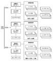
図3~図5はいずれも、移動データのデータ構造の例を示す図である。図3に示す移動データ231では、検索された複数の移動経路について一つの固有の移動ID「M1001」が割り当てられている。図4に示す移動データ232では、検索された3個の移動経路のそれぞれに一つの固有の移動IDが割り当てられている。具体的には、3個の移動経路に対応する移動データ232a,232b,232cが生成され、これらの移動データの移動IDがそれぞれ「M1001」、「M1002」、「M1003」と設定されている。図3および図4の例で示すように、情報共有システム1は、検索された1以上の移動経路のそれぞれについて移動データを生成してもよい。これに対して、図5に示す移動データ233では、検索された1以上の移動経路のうちユーザにより選択または利用された移動経路についてのみ固有の移動ID「M1001」が割り当てられている。図5の例のように、情報共有システム1は、検索された1以上の移動経路のうちユーザによって選択されなかった移動経路について移動データを生成することなく、検索された1以上の移動経路のうちユーザによって選択または利用された移動経路について移動データを生成してもよい。あるいは、移動データは他の任意のデータ構造を有してもよい。
コンピュータは移動データを参照することで、ユーザIDに対応するユーザデータと、移動経路を構成する個々のノードおよび個々のリンクに対応するノードデータおよびリンクデータを参照することができる。具体的には、コンピュータは移動IDを参照することで、該移動IDに関連付けられたユーザIDを特定し、このユーザIDに関連付けられたユーザ属性(すなわち、ユーザの属性情報)を参照することができる。さらに、コンピュータは移動IDを参照することで、該移動IDに関連付けられたノードIDを特定し、このノードIDに関連付けられたノード属性(すなわち、ノードの属性情報)を参照することができる。加えて、コンピュータは移動IDを参照することで、該移動IDに関連付けられたリンクIDを特定し、このリンクIDに関連付けられたリンク属性(すなわち、リンクの属性情報)を参照することができる。
移動データはユーザID、ノードID、およびリンクIDを含むので、コンピュータはこれらのIDに基づいて地図データベース21およびユーザデータベース22にアクセスして各種の属性情報を取得できる。あるいは、移動データは、少なくとも一部のユーザ属性、少なくとも一部のノード属性、および少なくとも一部のリンク属性のうちの少なくとも一つを含んでもよい。これは、属性情報の少なくとも一部がデータベース群20内で非正規化されて保持されることを意味する。
個々のデータの個々のデータ項目は静的に設定されてもよいし動的に設定されてもよい。「静的に設定される」とは、値が予め設定され、人手の介入がない限りはその設定が変更されないことをいう。一方、「動的に設定される」とは、値が任意の事象に応じて人手の介入無しに変更され得ることをいう。動的な設定は、所与のデータ項目を制御するプログラムが所定のコンピュータ上で実行されることで実現される。動的な設定は情報共有システム1により実行されてもよいし、別のコンピュータシステムにより実行されてもよい。
個々のデータの構造は限定されず、任意の方針でデータ構造が設計されてよい。例えば、地図データ、ユーザデータ、および移動データの少なくとも一つが任意の方針で正規化または非正規化されて一または複数のデータテーブル上に記憶されてもよい。
一例では、地図データ、ユーザデータ、および移動データは複数の事業者の間で共有される。したがって、それぞれの事業者はユーザの移動に関する情報を情報共有システム1から効率的に入手してその情報を利用することができる。例えば、事業者はユーザの移動に関連した様々なサービスまたは情報を提供したり、ユーザの移動に関連する情報を任意の手法で処理したりすることができる。プラットフォーマは複数の交通事業者を跨いだ横断的なサービスまたは情報をユーザに提供することができ、ユーザはそのサービスまたは情報を享受することができる。加えて、これらのデータが共有されることで、情報共有システム1の全体におけるデータベースの個数およびデータ容量を節約することができる
ノード属性およびリンク属性のそれぞれについて、少なくとも一部の情報は事業者によって提供されてもよく、例えば、個々の事業者のデータベースから提供されてもよい。あるいは、個々の事業者のデータベースが地図データベース21の役割の少なくとも一部を担ってもよい。
ノード属性およびリンク属性のそれぞれについて、少なくとも一部の情報は事業者によって提供されてもよく、例えば、個々の事業者のデータベースから提供されてもよい。あるいは、個々の事業者のデータベースが地図データベース21の役割の少なくとも一部を担ってもよい。
ユーザ端末30はユーザによって操作されるコンピュータである。ユーザ端末30は固定端末でもよいし携帯端末でもよい。ユーザ端末30の例として、携帯電話機、スマートフォン、タブレット端末、ウェアラブル端末、またはパーソナルコンピュータが挙げられるが、端末の種類はこれらに限定されない。情報共有システム1にアクセスするユーザ端末30の台数は限定されない。
事業者サーバ40は事業者によって管理または運用されるコンピュータである。事業者サーバ40として機能するコンピュータは限定されない。例えば、事業者サーバ40は業務用サーバなどの大型のコンピュータによって構成されてもよいし、パーソナルコンピュータによって構成されてもよい。情報共有システム1にアクセスする事業者サーバ40の台数は限定されない。
図6はプラットフォーマサーバ10の機能構成の一例を示す図である。プラットフォーマサーバ10は機能モジュールとして通信部11、検索部12、および生成部13を備える。通信部11は他のコンピュータとの間でデータを送受信する機能モジュールである。検索部12は移動経路を検索する機能モジュールである。生成部13は移動データを生成および格納する機能モジュールである。
[システムでの処理手順]
図7を参照しながら、情報共有システム1の動作を説明するとともに本実施形態に係る情報共有方法を説明する。図7は情報共有システム1の動作の一例を処理フローS1として示すフローチャートである。
図7を参照しながら、情報共有システム1の動作を説明するとともに本実施形態に係る情報共有方法を説明する。図7は情報共有システム1の動作の一例を処理フローS1として示すフローチャートである。
ステップS11では、通信部11がユーザ端末30から検索条件を受信する。ユーザはユーザ端末30を操作して、経路検索に必要な情報を入力し、その情報の送信を指示する。ユーザ端末30はその操作に応答して検索条件を生成し、この検索条件をプラットフォーマサーバ10に向けて送信する。通信部11はその検索条件を受信する。検索条件は、ユーザにより指定された出発地および目的地を少なくとも示すデータ信号である。検索条件は出発日時および到着日時のうちの少なくとも一つ、少なくとも一つの経由地などの、他のデータ項目をさらに含んでもよい。検索条件はユーザに関するデータ項目を含んでもよく、例えば、ユーザIDを含んでもよいし、ユーザ属性に関する少なくとも一つのデータ項目をさらに含んでもよい。
ステップS12では、検索部12がその検索条件を満たす移動経路を検索する。検索部12は検索条件に基づいて地図データベース21内の地図データを検索することで移動経路を抽出する。検索条件がユーザに関するデータ項目を含む場合には、検索部12は地図データベース21に加えてユーザデータベース22内のユーザデータを参照してもよい。検索部12は複数の移動経路を検索してもよく、例えば、道筋が互いに異なる複数の移動経路、道筋は同じだが交通手段または移動日時が互いに異なる複数の移動経路、あるいはこれらの移動経路の双方を検索してもよい。一例では、地図データは様々な事業者の情報と関連付けられるので、検索部12は様々な事業者から提供される様々な移動方法に対応する複数の移動経路を抽出し得る。すなわち、検索部12は複数の交通事業者を横断するかたちで複数の移動経路を一括して検索することができ、これはMaaSの一例であるといえる。
ステップS13では、通信部11が検索結果をユーザ端末30に向けて送信する。検索結果は、検索された1以上の移動経路を示すデータ信号である。ユーザ端末30はその検索結果を受信および表示し、これによりユーザはその検索結果を確認することができる。
ステップS14では、通信部11が、ユーザより選択された移動経路をユーザ端末30から受信する。ユーザはユーザ端末30を操作して所望の移動経路を選択する。ユーザ端末30はその操作に応答して、その選択された移動経路を示す情報をプラットフォーマサーバ10に向けて送信する。通信部11はその情報を受信する。
ステップS15では、生成部13が移動データを生成する。生成部13はユーザおよび選択された移動経路の組合せと、この組合せに対応する移動IDとを含む移動データを生成する。上述したように移動データのデータ構造が限定されないことに応じて、移動データの具体的な生成方法も限定されない。
一例では、生成部13はユーザIDと、ユーザによって選択された移動経路と、移動IDとを互いに関連付けることで移動データを生成する。この生成において、生成部13はその移動経路が計画経路であることを示すように経路属性を設定してもよい。
生成部13は、候補としてユーザに提示されたが該ユーザにより選択されなかった移動経路を示す移動データを生成してもよい。生成部13は検索結果を検索部12から取得することでその移動経路を特定することができる。
例えば、生成部13はユーザIDと、検索結果に対応する複数の移動経路と、一つの移動IDとを互いに関連付けることで移動データを生成する。この生成において、生成部13は複数の移動経路の経路属性を設定する。具体的には、生成部13は、ユーザにより選択された移動経路の経路属性を「計画」に設定し、ユーザにより選択されなかった移動経路の経路属性を「候補」に設定してもよい。
あるいは、生成部13は、検索結果に対応する複数の移動経路のそれぞれについて移動データを生成してもよい。生成部13は複数の移動経路のそれぞれについて、ユーザIDと、該移動経路と、移動IDとを互いに関連付けることで移動データを生成する。この場合も、生成部13はそれぞれの移動経路について経路属性を設定する。具体的には、生成部13は、ユーザにより選択された移動経路が計画経路であることを示し、ユーザにより選択されなかった経路が候補経路であることを示すように、それぞれの移動データにおいて経路属性を設定する。
ステップS16では、生成部13が移動データを移動データベース23に格納する。この処理によって、その移動データが複数の事業者によって共有可能になる。
図8および図9を参照しながら経路検索の一例を説明する。図8は経路検索の結果の一例を示す図である。図9はその検索結果に対応する移動データの一例を示す図である。図8に示すように、検索部12が出発地Sから目的地Gまでの移動経路として、ノードA,B,Eを順に経由する移動経路301と、ノードA,F,H,Dを順に経由する移動経路302と、ノードA,B,C,Dを順に経由する移動経路303とを抽出したとする。その後、ユーザID「U2101」を有するユーザが移動経路303を選択したとする。この場合、生成部13は例えば図9に示す移動データ234を生成してもよい。この移動データ234の移動ID「M1101」は、ユーザIDおよび移動経路301の組合せと、ユーザIDおよび移動経路302の組合せと、ユーザIDおよび移動経路303の組合せとに対応する。ユーザは移動経路303を選択したので、生成部13は移動経路303の経路属性を「計画」に設定し、移動経路301,302の経路属性を「候補」に設定する。
[システムおよび移動データの利用]
図10は経路検索の一例を示す図である。上述したように、情報共有システム1は複数の交通事業者を横断するかたちで複数の移動経路を一括して検索することができる。図10の例では、情報共有システム1は出発地Sから目的地Gまでの移動経路として、事業者Pから提供される交通手段61と、事業者Qから提供される交通手段62と、事業者Rから提供される交通手段63との組合せに基づく検索結果を提供する。ユーザ51はこの検索結果から所望の移動経路を選択することができる。
図10は経路検索の一例を示す図である。上述したように、情報共有システム1は複数の交通事業者を横断するかたちで複数の移動経路を一括して検索することができる。図10の例では、情報共有システム1は出発地Sから目的地Gまでの移動経路として、事業者Pから提供される交通手段61と、事業者Qから提供される交通手段62と、事業者Rから提供される交通手段63との組合せに基づく検索結果を提供する。ユーザ51はこの検索結果から所望の移動経路を選択することができる。
図11は、ユーザ52により選択された移動経路の利用の一例を示す図である。この例では、ユーザ52が車椅子を利用する人であるとする。ユーザ52はユーザ端末30を用いて、これから進む経路に関する様々なサービス情報、例えば交通情報、周辺施設の情報、天気予報、広告、クーポンなどを得ることができる。あるいは、ユーザ52はユーザ端末30を用いて各種の予約、例えば座席の予約、補助員の手配などを行うこともできる。それぞれの事業者は、ユーザIDに対応する移動データおよびユーザデータを参照することで、どのような人が交通機関を利用するかを事前に把握して、必要な対応を取ることができる。例えば、交通手段61,63に対応する事業者P,Rはそれぞれ、車椅子で移動するユーザ52のために、乗降を補助するためのスタッフを配置させることができる。
図12は、ユーザ53により利用された移動経路に関する決済の一例を示す図である。例えば、移動データによって示される移動経路とユーザ端末30の位置情報の履歴から特定可能なユーザ53の移動の実績とに基づく自動決済を実現することができる。利用料が自動的に決済されるので、ユーザ53は交通機関を利用する度に支払う必要がない。プラットフォーマは、このような便利な仕組みをユーザ53に提供する対価としてユーザ53から利用料を得ることができ、この利用料も自動的に決済されてよい。
移動データベース23に蓄積された移動データは様々な処理を可能にする。また、その移動データは、人の移動に関する様々な事象の可視化に貢献する。以下に、移動データの利用についての様々な例を示す。
経路検索に関しては、上述したように、複数種類の交通機関を任意に組み合わせることで得られる複数の移動経路を提供することが可能になる。これは、マルチモーダルな移動手段の提示の一例であるといえる。移動経路は、駐車場に関する情報を含んでもよく、例えば、駐車場の位置、空き状況、または料金を含んでもよい。あるいは、移動経路は相乗りに関する情報提供または提案を含んでもよい。
選択された移動経路に関してユーザに提供されるサービス情報の例として、交通機関または施設に関する広告またはクーポン、乗換を考慮した最適な乗車位置の案内、同額での迂回路の案内、代替の移動手段の案内、最適な改札口の案内、観光情報、相乗りの案内、駐車場の案内、旅行の案内、電子的な遅延証明の発行などが挙げられる。選択された移動経路に関連する予約も実現し得る。その予約の例として、交通機関の座席、駐車場、各種施設の利用、補助員などについての予約が挙げられる。選択された移動経路に関連する決済も実現し得る。その決済の例として、定期券との差額の決済、改札機を用いない自動決済、割り勘による決済、割引の提案、企業の交通費精算の自動化などが挙げられる。
蓄積された移動データが各種の統計または解析に用いられてもよい。例えば、移動データは、混雑度の算出、新しい経路の提案、需要予測、選択された移動経路と選択されなかった移動経路との差異の検証、マーケティングまたは広告に関する提案、不動産価格の評価または決定、都市計画または交通計画、施設の評価、待ち時間の予測、人流解析、在庫の適正化、交通機関の時刻表の最適化、サイネージなどによる案内の適正化などに用いられ得る。
[プログラム]
コンピュータをプラットフォーマサーバ10として機能させるためのプログラムは、該コンピュータを通信部11、検索部12、および生成部13として機能させるためのプログラムコードを含む。このプログラムは、CD-ROM、DVD-ROM、半導体メモリなどの非一時的な記録媒体に固定的に記録された上で提供されてもよい。あるいは、プログラムは、搬送波に重畳されたデータ信号として通信ネットワークを介して提供されてもよい。提供されたプログラムはストレージ103に記憶され、プロセッサ101がメモリ102と協働してそのプログラムを実行することで上記の各機能モジュールが実現する。
コンピュータをプラットフォーマサーバ10として機能させるためのプログラムは、該コンピュータを通信部11、検索部12、および生成部13として機能させるためのプログラムコードを含む。このプログラムは、CD-ROM、DVD-ROM、半導体メモリなどの非一時的な記録媒体に固定的に記録された上で提供されてもよい。あるいは、プログラムは、搬送波に重畳されたデータ信号として通信ネットワークを介して提供されてもよい。提供されたプログラムはストレージ103に記憶され、プロセッサ101がメモリ102と協働してそのプログラムを実行することで上記の各機能モジュールが実現する。
[効果]
以上説明したように、本開示の一側面に係るコンピュータシステムは少なくとも一つのプロセッサを備える。少なくとも一つのプロセッサは、複数の事業者の間で共有される地図データを記憶する地図データベースを参照して、ユーザにより指定された出発地および目的地を少なくとも示す検索条件に対応する1以上の移動経路を検索し、検索された1以上の移動経路のうちの少なくとも一つの移動経路のそれぞれについて、ユーザおよび該移動経路の組合せと、該組合せに対応する移動IDとが関連付けられた移動データを生成し、生成された移動データを複数の事業者が共有できるように該移動データを移動データベースに格納する。
以上説明したように、本開示の一側面に係るコンピュータシステムは少なくとも一つのプロセッサを備える。少なくとも一つのプロセッサは、複数の事業者の間で共有される地図データを記憶する地図データベースを参照して、ユーザにより指定された出発地および目的地を少なくとも示す検索条件に対応する1以上の移動経路を検索し、検索された1以上の移動経路のうちの少なくとも一つの移動経路のそれぞれについて、ユーザおよび該移動経路の組合せと、該組合せに対応する移動IDとが関連付けられた移動データを生成し、生成された移動データを複数の事業者が共有できるように該移動データを移動データベースに格納する。
本開示の一側面に係るプログラムは、複数の事業者の間で共有される地図データを記憶する地図データベースを参照して、ユーザにより指定された出発地および目的地を少なくとも示す検索条件に対応する1以上の移動経路を検索するステップと、検索された1以上の移動経路のうちの少なくとも一つの移動経路のそれぞれについて、ユーザおよび該移動経路の組合せと、該組合せに対応する移動IDとが関連付けられた移動データを生成するステップと、生成された移動データを複数の事業者が共有できるように該移動データを移動データベースに格納するステップとをコンピュータに実行させる。
このような側面においては、ユーザおよび移動経路の組合せに移動IDが関連付けられた移動データがデータベースに登録される。この移動データによってユーザと移動経路との個々の対応関係を把握できるので、出発地から目的地までの移動経路を適切に管理することが可能になる。
他の側面に係るコンピュータシステムでは、移動IDが、組合せを一意に特定する識別子であってもよい。この場合には、ユーザと移動経路との個々の対応関係を移動IDのみを用いて識別することができる。
他の側面に係るコンピュータシステムでは、少なくとも一つのプロセッサが、検索された1以上の移動経路のそれぞれについて移動データを生成してもよい。この場合には、ユーザに選択されたか否かにかかわらず、検索された移動経路のすべてについて、ユーザとの対応関係を移動IDを用いて管理することができる。
他の側面に係るコンピュータシステムでは、少なくとも一つのプロセッサが、検索された1以上の移動経路のうちユーザによって選択されなかった移動経路について移動データを生成することなく、検索された1以上の移動経路のうちユーザによって選択または利用された移動経路について移動データを生成してもよい。このように、移動データベースに格納する移動データを限定することで、このデータベースの記憶容量と、用いられる移動IDの個数とを節約することができる。
他の側面に係るコンピュータシステムでは、少なくとも一つのプロセッサが、複数のノードIDおよび複数のリンクIDによって移動経路を示す移動データを生成してもよい。ノードIDは、地図を構成するノードを一意に特定する識別子であり、かつ該ノードの属性情報と関連付けられる。リンクIDは、隣接するノード間を結ぶリンクを一意に特定する識別子であり、且つ該リンクの属性情報と関連付けられる。このようなデータ構造によって、移動経路を構成する個々のノードおよび個々のリンクの詳細を移動データから得ることが可能になるので、移動経路を適切に管理することができる。
他の側面に係るコンピュータシステムでは、ノードが交通結節点であってもよい。移動経路において重要な場所である交通結節点にノードを限定することで、個々の移動経路の特徴を的確に移動データによって表現することができる。加えて、移動経路を表現するために用いられるノードIDの個数が抑えられるので、個々の移動データのデータサイズを抑制できる。
他の側面に係るコンピュータシステムでは、少なくとも一つのプロセッサが、候補として検索された経路と、ユーザにより選択された経路と、ユーザにより実際に利用された経路とのうちの少なくとも一つを示す経路属性を含む移動データを生成してもよい。このような経路属性を移動データに埋め込むことで、ユーザと移動経路との関係を移動データから特定することが可能になる。
[変形例]
以上、本開示をその実施形態に基づいて詳細に説明した。しかし、本開示は上記実施形態に限定されるものではない。本開示は、その要旨を逸脱しない範囲で様々な変形が可能である。
以上、本開示をその実施形態に基づいて詳細に説明した。しかし、本開示は上記実施形態に限定されるものではない。本開示は、その要旨を逸脱しない範囲で様々な変形が可能である。
図13は、移動データのデータ構造の他の例を示す図である。500は基本情報であり、以下で説明する情報を含む。510は移動IDであり、基本情報500、計画経路情報600及び実績経路情報700の組み合わせにより得られる情報を一意に特定するための管理情報である。520はユーザIDであり、ユーザを一意に特定する識別子である。このユーザIDは、他のデータ項目と関連付けられる際に、個人を特定できないように匿名化ないし暗号化の加工を施されてもよい。こうすることで、事業者はユーザの移動に関する情報を、ユーザの立ち回り先に関する情報として個人を特定しない形で入手でき、個人情報保護の要請をみたすデータ流通が可能となる。530は経路発行事業者IDである。当該IDは、プラットフォーマ等、移動データを生成する処理を行う情報共有システム1の管理者または運営者を表すものである。540は、移動IDの表す移動経路の始点としての開始ノードの情報である。550は、移動IDの表す移動経路の終点としての終了ノードの情報である。600は計画経路情報、すなわち計画経路を表す情報であり、以下で説明する情報を含む。610は経路コードであり、計画経路を一意に特定するための管理情報である。620は移動手段の情報であり、計画経路をユーザが移動する際に使用する交通手段(徒歩を含む。以下同じ。)を表す。なお、その計画経路において、複数の交通手段を利用する場合は、複数の交通手段が記憶される。630は出発予定時間の情報であり、ユーザが計画経路にそって移動を開始する予定時間である。640は到着予定時間の情報であり、ユーザが計画経路にそった移動を終了する予定時間である。650はリンクリストであり、計画経路を構成する個々のリンク及びリンクのつながり方をあらわす情報であり、以下で説明する情報を含む。651はリンクIDであり、計画経路を構成する個々のリンクを一意に特定する識別子である。652は移動手段の情報であり、移動経路を構成する個々のリンクをユーザが移動する交通手段を表す情報である。653は運賃の情報であり、リンクの通過に料金がかかること及び/又は当該料金を表す。654はリンクの出発予定時間の情報であり、特定のリンクの始点から移動する予定時間である。655はリンクの到着予定時間の情報であり、特定のリンクの終点に到着する予定時間である。700は実績経路情報、すなわちユーザによって利用された実績経路を表す情報であり、以下で説明する情報を含む。710は経路コードであり、実績経路を一意に特定するための管理情報である。ここでは計画経路とは異なる経路であってもユーザがたどった経路が記述される。720は移動状況の情報であり、リンクの残り距離、リンクを通過するときの交通手段等、ユーザが実際に移動したときの、特定のリンクの始点を通過した後、当該リンクの終点を通過するまでの移動状況を表す。730は滞在中リンクの情報であり、ユーザの現在地がマップマッチング等により対応付けられたリンクを表す。740はリンク情報であり、以下で説明する情報を含む。741はリンクIDであり、実績経路を構成する個々のリンクを特定する識別子である。742は出発実績時間の情報であり、特定のリンクをユーザが移動し始めた時間を表す。743は到着実績時間の情報であり、特定のリンクをユーザが移動し終えた時間を表す。なお、基本情報500、計画経路情報600及び実績経路情報700は、関連つけられている。
上記の移動データは、図1のプラットフォーマサーバ10において生成されて、ユーザの移動開始前に情報共有システム1の利用主体である事業者の間で共有される。ユーザが候補経路から計画経路を決定する。計画経路が決定されると、プラットフォーマサーバ10が移動ID510(経路情報と対応)とユーザID520等を関連付けた基本情報500、計画経路情報600及び実績経路情報700を含む移動データを生成する。その後、出発予定時間近辺に、ユーザが移動を開始すると、ユーザの移動に従い、ユーザ端末30の現在地の位置情報の履歴をプラットフォーマサーバ10が把握する。プラットフォーマサーバ10は、移動状況720、滞在中リンク730の情報及びリンク情報740を、その履歴に従って生成し、移動データベース23に蓄積する。つまり、現在地の位置情報と地図データベース21のリンクとがマップマッチングされるのを契機に実績経路のデータの生成が開始され、移動データベース23に蓄積される。蓄積された実績経路のデータは次のように事業者間で共有される。
蓄積された移動データは、計画経路又は候補経路と実績経路とを照合したデータとして、あるいは実績経路だけのデータとして、情報共有システム1を維持運営する上での事業者間協力の取り組みの一環として情報共有され、ユーザ行動に関するビッグデータとして活用されうる。さらに、蓄積された移動データのうち実績経路の情報は、ユーザが交通手段を切り替える間に、所定料金での乗継許容時間中にユーザが滞在した場所及び滞在時間を割り出すためのデータとして用いられうる。すなわち、例えばエキナカ・エキチカ等の交通結節点付近におけるユーザの消費行動を推定するためのデータとして利用されうる。
また、移動データが事業者サーバ40に共有されることにより、以下のように利用される。ユーザが移動をした経路である実績経路の情報とユーザが移動するために計画された計画経路の情報とを関連づけた情報である移動データ(基本情報500、計画経路情報600及び実績経路情報700又は計画経路情報600及び実績経路情報700)を、事業者サーバ40に共有する。そして、事業者サーバ40は、ユーザが移動をした経路である実績経路である実績経路情報700とユーザが移動するために計画された計画経路の情報である計画経路情報600とを比較することにより、実績経路情報700から特定される実績経路を修正する。例えば、通常のマップマッチング処理により実績経路の一部が第1の路線を示していた場合であって、その路線に並走する第2の路線が存在し、計画経路の一部が第2の路線を示すときは以下の処理を行う。実績経路の全体の経路と計画経路の第2の路線を考慮して、第2の路線が適切であると判断した場合、実績経路の第1の路線を第2の路線に変更する。また、事業者サーバ40は、実績経路情報700と計画経路情報600とを比較することにより、実績経路と計画経路との差異を特定し、その差異の原因を解析する。事業者サーバ40は、差異の原因を解析することによって、混雑度の算出、新しい経路の提案、需要予測、マーケティングまたは広告に関する提案、不動産価格の評価または決定、都市計画または交通計画、施設の評価、待ち時間の予測、人流解析、在庫の適正化、交通機関の時刻表の最適化、サイネージなどによる案内の適正化などの処理を行う。差異は、交通手段の差異(計画経路では、ある区間はバスであるが、実績経路では、ある区間はタクシーなど)、経路の差異(計画経路と実績経路とが、ある地点からある地点まで別の経路となっているなど)、あるリンクを通過する時間の差異などが存在する。なお、プラットフォーマサーバ10は、基本情報500を切り離した計画経路情報600及び実績経路情報700を含む移動データを事業者サーバ40に共有しても良い。事業者サーバ40が、解析を行うにあたり、特定のユーザの情報やユーザの属性が必要ない場合に有効である。なお、計画経路情報600は経路コード610を有し、一意に特定され、実績経路情報700は、経路コード710を有し、一意に特定されているため、事業者サーバ40は、各々情報を適切に識別し、解析を行える。
また、事業者サーバ40は、基本情報500のユーザID及び計画経路情報600を参照することにより、特定のユーザに対して、適切な時間及び場所で、情報(宣伝・広告など)を提供したり、サービス(上記の実施形態の車椅子の人への補助サービスなど)を提供できるようにする。また、地域毎に一つずつ複数のプラットフォーマが存在し、それらが連携しているシステムの場合、事業者サーバ40は、経路発行事業者ID530を参照して、事業者が情報又はサービスを提供したユーザの計画経路情報が、いずれのプラットフォーマ10を介して共有されたかを識別する。そして、事業者サーバ40は、そのユーザとの取引(例えば、提供したサービス等に対する費用の請求)を、プラットフォーマサーバ10を介して行う。なお、上記において、計画経路情報600は、計画経路ではなく、候補経路の情報であっても良い。また、移動データの事業者サーバ40への共有は、移動データを移動データベース23に格納する方法であってもよく、移動データを事業者サーバ40に提供する方法であっても良い。つまり、移動データを事業者に利用可能とするものであれば良い。
上記実施形態ではデータベース群20を示すが、各データベースのコピーがプラットフォーマおよび複数の事業者のそれぞれに配置されてもよい。この場合には、プラットフォーマおよび複数の事業者の間でデータベースの同期が実行され、これにより各種のデータの整合性が保証される。
本開示において、「少なくとも一つのプロセッサが、第1の処理を実行し、第2の処理を実行し、…第nの処理を実行する。」との表現、またはこれに対応する表現は、第1の処理から第nの処理までのn個の処理の実行主体(すなわちプロセッサ)が途中で変わる場合を含む概念を示す。すなわち、この表現は、n個の処理のすべてが同じプロセッサで実行される場合と、n個の処理においてプロセッサが任意の方針で変わる場合との双方を含む概念を示す。
コンピュータシステム内で二つの数値の大小関係を比較する際には、「以上」および「よりも大きい」という二つの基準のどちらを用いてもよく、「以下」および「未満」の二つの基準のうちのどちらを用いてもよい。このような基準の選択は、二つの数値の大小関係を比較する処理についての技術的意義を変更するものではない。
少なくとも一つのプロセッサにより実行される方法の処理手順は上記実施形態での例に限定されない。例えば、上述したステップ(処理)の一部が省略されてもよいし、別の順序で各ステップが実行されてもよい。また、上述したステップのうちの任意の2以上のステップが組み合わされてもよいし、ステップの一部が修正または削除されてもよい。あるいは、上記の各ステップに加えて他のステップが実行されてもよい。
以上の実施形態の全部または一部に記載された態様は、移動経路に関する制御、処理速度の向上、処理精度の向上、使い勝手の向上、データを利用した機能の向上または適切な機能の提供その他の機能向上または適切な機能の提供、データおよび/またはプログラムの容量の削減、装置および/またはシステムの小型化等の適切なデータ、プログラム、記録媒体、装置および/またはシステムの提供、並びにデータ、プログラム、装置またはシステムの制作・製造コストの削減、制作・製造の容易化、制作・製造時間の短縮等のデータ、プログラム、記録媒体、装置および/またはシステムの制作・製造の適切化のいずれか一つの課題を解決する。
本出願は、2019年7月1日出願の日本特許出願2019-122676に基づくものであり、その内容はここに参照として取り込まれる。
1…情報共有システム、10…プラットフォーマサーバ、20…データベース群、21…地図データベース、22…ユーザデータベース、23…移動データベース、30…ユーザ端末、40…事業者サーバ、11…通信部、12…検索部、13…生成部、231~233…移動データ
Claims (8)
- 制御部を備えたコンピュータシステムであって、
前記制御部は、
ユーザが移動をした経路である実績経路の情報と、
前記ユーザが移動するために計画された計画経路の情報又は候補として検索された候補経路の情報の少なくとも一の情報と、
を関連づけた経路情報を、事業者に利用可能にする、
コンピュータシステム。 - 請求項1に記載のコンピュータシステムであって、
前記経路情報には、他の経路情報と識別するための第一のIDが関連付けられた、
コンピュータシステム。 - 請求項1に記載のコンピュータシステムであって、
前記経路情報には、前記ユーザを表す第二のIDが関連付けられた、
コンピュータシステム。 - 請求項1に記載のコンピュータシステムであって、
前記制御部はさらに、前記経路情報を生成する、
コンピュータシステム。 - 請求項1に記載のコンピュータシステムであって、
前記制御部はさらに、前記経路情報を前記事業者が利用可能となるように、前記経路情報を所定のデータベースに格納する、
コンピュータシステム。 - 請求項1に記載のコンピュータシステムであって、
前記制御部はさらに、前記経路情報を前記事業者が利用可能となるように、前記経路情報を所定のデータベースに格納し、当該所定のデータベースには、地図データが含まれる、
コンピュータシステム。 - ユーザが移動をした経路である実績経路の情報と、前記ユーザが移動するために計画された計画経路の情報又は候補として検索された候補経路の情報の少なくとも一種類の情報を関連づけた経路情報を、事業者に利用可能とするステップをコンピュータに実行させるプログラムを記憶した記憶媒体。
- ユーザが移動をした経路である実績経路の情報と、前記ユーザが移動するために計画された計画経路の情報又は候補として検索された候補経路の情報の少なくとも一種類の情報を関連づけた経路情報を、事業者に利用可能とするステップをコンピュータに実行させるプログラム。
Priority Applications (1)
| Application Number | Priority Date | Filing Date | Title |
|---|---|---|---|
| JP2021529957A JPWO2021002218A1 (ja) | 2019-07-01 | 2020-06-19 |
Applications Claiming Priority (2)
| Application Number | Priority Date | Filing Date | Title |
|---|---|---|---|
| JP2019-122676 | 2019-07-01 | ||
| JP2019122676 | 2019-07-01 |
Publications (1)
| Publication Number | Publication Date |
|---|---|
| WO2021002218A1 true WO2021002218A1 (ja) | 2021-01-07 |
Family
ID=74100341
Family Applications (1)
| Application Number | Title | Priority Date | Filing Date |
|---|---|---|---|
| PCT/JP2020/024063 WO2021002218A1 (ja) | 2019-07-01 | 2020-06-19 | コンピュータシステムおよび記憶媒体並びにプログラム |
Country Status (2)
| Country | Link |
|---|---|
| JP (2) | JP7397713B2 (ja) |
| WO (1) | WO2021002218A1 (ja) |
Families Citing this family (3)
| Publication number | Priority date | Publication date | Assignee | Title |
|---|---|---|---|---|
| JP7431779B2 (ja) | 2021-07-19 | 2024-02-15 | Lineヤフー株式会社 | 情報処理装置、情報処理方法、およびプログラム |
| WO2023053474A1 (ja) * | 2021-09-28 | 2023-04-06 | 日本電気株式会社 | 介助要員手配システム、介助プラットフォームシステム、介助要員手配方法、およびコンピュータ読み取り可能な記憶媒体 |
| WO2023053475A1 (ja) * | 2021-09-28 | 2023-04-06 | 日本電気株式会社 | 移動経路情報提供システム、介助プラットフォームシステム、移動経路情報提供方法、およびコンピュータ読み取り可能な記憶媒体 |
Citations (3)
| Publication number | Priority date | Publication date | Assignee | Title |
|---|---|---|---|---|
| JP2000046576A (ja) * | 1998-07-29 | 2000-02-18 | Nec Corp | 移動体誘導装置及びその方法並びにプログラムを記録した機械読み取り可能な記録媒体 |
| JP2003214870A (ja) * | 2002-01-23 | 2003-07-30 | Mazda Motor Corp | ナビゲーション方法及び装置、並びにそのコンピュータ・プログラム |
| JP2015010889A (ja) * | 2013-06-27 | 2015-01-19 | 株式会社コスモルート | 判断プログラム、判断サーバ、及び、判断システム |
Family Cites Families (4)
| Publication number | Priority date | Publication date | Assignee | Title |
|---|---|---|---|---|
| JP2001093088A (ja) | 1999-09-21 | 2001-04-06 | Hitachi Eng Co Ltd | 輸送運行管理システム |
| JP4754444B2 (ja) | 2006-09-05 | 2011-08-24 | パナソニック株式会社 | 走行軌跡管理システム |
| JP2009298541A (ja) | 2008-06-12 | 2009-12-24 | Pasuko:Kk | ルート決定支援装置及びルート決定支援プログラム |
| JP6237801B2 (ja) | 2016-02-22 | 2017-11-29 | 富士通株式会社 | 運行支援プログラム、運行支援方法および運行支援装置 |
-
2020
- 2020-02-21 JP JP2020028239A patent/JP7397713B2/ja active Active
- 2020-06-19 WO PCT/JP2020/024063 patent/WO2021002218A1/ja active Application Filing
- 2020-06-19 JP JP2021529957A patent/JPWO2021002218A1/ja active Pending
Patent Citations (3)
| Publication number | Priority date | Publication date | Assignee | Title |
|---|---|---|---|---|
| JP2000046576A (ja) * | 1998-07-29 | 2000-02-18 | Nec Corp | 移動体誘導装置及びその方法並びにプログラムを記録した機械読み取り可能な記録媒体 |
| JP2003214870A (ja) * | 2002-01-23 | 2003-07-30 | Mazda Motor Corp | ナビゲーション方法及び装置、並びにそのコンピュータ・プログラム |
| JP2015010889A (ja) * | 2013-06-27 | 2015-01-19 | 株式会社コスモルート | 判断プログラム、判断サーバ、及び、判断システム |
Also Published As
| Publication number | Publication date |
|---|---|
| JP2021009675A (ja) | 2021-01-28 |
| JPWO2021002218A1 (ja) | 2021-01-07 |
| JP7397713B2 (ja) | 2023-12-13 |
Similar Documents
| Publication | Publication Date | Title |
|---|---|---|
| Braca et al. | A computerized approach to the New York Cityschool bus routing problem | |
| Chakrabarti | How can public transit get people out of their cars? An analysis of transit mode choice for commute trips in Los Angeles | |
| WO2021002218A1 (ja) | コンピュータシステムおよび記憶媒体並びにプログラム | |
| JP7201394B2 (ja) | 情報提供装置、情報提供システム、情報提供方法、情報提供プログラム | |
| Nodjomian et al. | How does the built environment affect interest in the ownership and use of self-driving vehicles? | |
| Coffel | Guidelines for providing access to public transportation stations | |
| Nakashima et al. | One cycle of smart access vehicle service development | |
| JP7173694B2 (ja) | データ生成装置、データ生成システム、データ生成方法、データ生成プログラム | |
| Su et al. | The multimodal trip planning system of intercity transportation in Taiwan | |
| EP3441914A1 (en) | Transportation network user demand prediction | |
| Beigi et al. | Station reallocation and rebalancing strategy for bike-sharing systems: a case study of Washington DC | |
| Saintika et al. | Readiness of Operating Bus Rapid Transit (BRT) Purwokerto-Purbalingga towards Smart City Concept | |
| Evans et al. | Transit oriented development | |
| JP6666507B1 (ja) | コンピュータシステム、およびプログラム | |
| JP2006099674A (ja) | 通勤経路演算システム及び演算方法 | |
| Vanderwaart | Planning transit networks with origin, destination, and interchange inference | |
| JP2021009680A (ja) | コンピュータシステムおよびプログラム | |
| JP2021009679A (ja) | コンピュータシステムおよびプログラム | |
| JP2021189818A (ja) | コンピュータシステムおよびプログラム | |
| Busby | Accessibility-based transit planning | |
| JP2022064058A (ja) | サーバ装置およびプログラム | |
| Bourée et al. | INSPIRE-MMTIS: overlap in standards related to the Delegated Regulation (EU) 2017/1926 | |
| Jevinger et al. | Context-Aware Travel Support During Unplanned Public Transport Disturbances. | |
| Belz et al. | Car sharing: A feasibility study in Hong Kong | |
| JP7488099B2 (ja) | コンピュータシステムおよびプログラム |
Legal Events
| Date | Code | Title | Description |
|---|---|---|---|
| 121 | Ep: the epo has been informed by wipo that ep was designated in this application |
Ref document number: 20835162 Country of ref document: EP Kind code of ref document: A1 |
|
| ENP | Entry into the national phase |
Ref document number: 2021529957 Country of ref document: JP Kind code of ref document: A |
|
| NENP | Non-entry into the national phase |
Ref country code: DE |
|
| 122 | Ep: pct application non-entry in european phase |
Ref document number: 20835162 Country of ref document: EP Kind code of ref document: A1 |