WO2020261697A1 - ナビゲーション装置、経路案内方法、及びコンピュータプログラム - Google Patents
ナビゲーション装置、経路案内方法、及びコンピュータプログラム Download PDFInfo
- Publication number
- WO2020261697A1 WO2020261697A1 PCT/JP2020/015342 JP2020015342W WO2020261697A1 WO 2020261697 A1 WO2020261697 A1 WO 2020261697A1 JP 2020015342 W JP2020015342 W JP 2020015342W WO 2020261697 A1 WO2020261697 A1 WO 2020261697A1
- Authority
- WO
- WIPO (PCT)
- Prior art keywords
- parking
- destination
- priority
- prohibited
- unit
- Prior art date
- Legal status (The legal status is an assumption and is not a legal conclusion. Google has not performed a legal analysis and makes no representation as to the accuracy of the status listed.)
- Ceased
Links
Images






Classifications
-
- G—PHYSICS
- G01—MEASURING; TESTING
- G01C—MEASURING DISTANCES, LEVELS OR BEARINGS; SURVEYING; NAVIGATION; GYROSCOPIC INSTRUMENTS; PHOTOGRAMMETRY OR VIDEOGRAMMETRY
- G01C21/00—Navigation; Navigational instruments not provided for in groups G01C1/00 - G01C19/00
- G01C21/26—Navigation; Navigational instruments not provided for in groups G01C1/00 - G01C19/00 specially adapted for navigation in a road network
- G01C21/34—Route searching; Route guidance
-
- G—PHYSICS
- G09—EDUCATION; CRYPTOGRAPHY; DISPLAY; ADVERTISING; SEALS
- G09B—EDUCATIONAL OR DEMONSTRATION APPLIANCES; APPLIANCES FOR TEACHING, OR COMMUNICATING WITH, THE BLIND, DEAF OR MUTE; MODELS; PLANETARIA; GLOBES; MAPS; DIAGRAMS
- G09B29/00—Maps; Plans; Charts; Diagrams, e.g. route diagram
- G09B29/10—Map spot or coordinate position indicators; Map reading aids
Definitions
- This disclosure relates to navigation devices, route guidance methods, and computer programs.
- cleaning shops and cram schools around stations often do not have their own parking lots.
- parking is prohibited on the roads around the destination such as the above-mentioned cleaning shop or cram school, or if parking is restricted depending on the time of day, the driver can park the vehicle around the destination. For example, it is necessary to find a road or toll parking lot where parking is possible on the street.
- Patent Document 1 discloses searching for a parkable road having the lowest walking cost, which is an index of ease of walking between a destination and a parkable road.
- some drivers want to avoid not only the ease of walking, but also the desire to park in a parking lot where they can park safely even if they pay a fee, and to avoid driving on narrow roads or difficult-to-enter roads.
- the technique disclosed in Patent Document 1 does not necessarily provide a parkingable position suitable for the driver's request.
- Patent Document 1 has a problem that it is not possible to provide a parkingable position suitable for the driver's request.
- the present disclosure has been made in order to solve such a conventional problem, and the purpose of the present disclosure is a navigation device capable of guiding a parkingable position suitable for a driver's request, and route guidance. To provide methods and computer programs.
- parking is prohibited on the route guide unit for guiding the route to the destination and the road around the destination at the estimated arrival time at the destination.
- the parking / stopping prohibition information acquisition unit that acquires parking / stopping prohibition information, which is information on whether parking / stopping is prohibited, and the surrounding road are prohibited from parking or parking at the expected arrival time.
- It also has a parkable position search unit for searching a parkable position in a surrounding area set around the surrounding road, and is desired based on the priority of a plurality of preset parkable position conditions. It is characterized in that a parkable position is set and the destination of route guidance is changed to the desired parkable position.
- the route guidance method is whether or not the roads around the destination are prohibited from parking or parking at the step of guiding the route to the destination and the estimated arrival time at the destination.
- a desired parkable position is set based on a step of searching for a possible position and a priority of a plurality of preset parkable position conditions, and a route guidance destination is changed to the desired parkable position. It is characterized by having steps.
- the step of acquiring parking / stopping prohibition information which is the information of, and when the surrounding road is prohibited from parking or parking at the expected arrival time, parking is possible in the surrounding area set around the surrounding road.
- FIG. 1 is a block diagram showing a configuration of a navigation device and its peripheral devices according to an embodiment of the present invention.
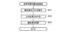
- FIG. 2 is a flowchart showing a first procedure of the process of setting the priority of the parking position.
- FIG. 3 is a flowchart showing a second procedure of the process of setting the priority of the parking position.
- FIG. 4 is a flowchart showing a third procedure of the process of setting the priority of the parking position.
- FIG. 5 is a flowchart showing the procedure of the destination setting process.
- FIG. 6 is a diagram showing a display example of a screen for setting the priority of the parking position.
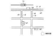
- FIG. 7 is a map showing a map in the area around the destination and an explanatory diagram showing the parkingable position, and shows an example in which the parkingable position closest to the destination is emphasized and displayed.
- FIG. 8 is a map showing a map in the area around the destination and an explanatory diagram showing the parkingable position, and shows an example in which the toll parking lot is highlighted and displayed.
- FIG. 9 is a map showing a map in the area around the destination and an explanatory diagram showing the parkingable position, and shows an example in which a toll parking lot with a low charge is emphasized and displayed.
- FIG. 10 is an explanatory diagram showing a map in the area around the destination and a parkingable position, and shows an example in which a toll parking lot with a high vacancy rate is emphasized and displayed.
- FIG. 11 is an explanatory diagram showing a map in the area around the destination and a parkingable position, and shows an example in which an easily accessible toll parking lot is emphasized and displayed.
- FIG. 12 is an explanatory diagram showing a map in the area around the destination and a parking available position, and shows an example of highlighting and displaying an accessible toll parking lot while avoiding a congested road.
- FIG. 13 is a flowchart showing the procedure of the destination setting process according to the second embodiment.
- FIG. 1 is a block diagram showing a configuration of a route guidance system 100 including a navigation device 1 according to an embodiment of the present invention.
- the route guidance system 100 is mounted on a vehicle or carried by a occupant of the vehicle, and the navigation device 1 is connected to the navigation device 1 via a network 3. It is equipped with a base station server 2 that is capable of communication and is provided in a base station or the like away from the vehicle.
- the base station server 2 includes a communication unit 22 that communicates with the navigation device 1 via the network 3 and a database 23.
- the database 23 also includes a map database 231 and a parking / stopping prohibition database 232.
- the map database 231 stores map data for route guidance.
- Map data includes information such as one-way streets, road widths, and traffic restrictions. In addition, information on toll parking lots facing the road and information on parking fees are included.
- the parking / stopping prohibition database 232 stores data indicating parking prohibition and parking / stopping prohibition on the shoulder of the road included in the map database 231. Further, when the possibility of parking or parking / stopping is changed depending on the time zone, data indicating parking prohibition or parking / stopping prohibition according to the time zone is stored. For example, in the case of a road where parking is prohibited during the time period from 8:00 am to 5:00 pm and parking is possible at other times, 8:00 am is stored as the time when the parking is prohibited. 5 pm is stored as the time when the parking is changed.
- the navigation device 1 is a device that guides a route from a current location or an arbitrary position to a destination designated by a user (for example, a driver of a vehicle), and is mounted on a vehicle, for example. Alternatively, it is a terminal device (for example, a smartphone) carried by the user. In this embodiment, an example in which the navigation device 1 is mounted on a vehicle will be described as an example.
- the navigation device 1 includes a GPS receiving unit 11 for receiving GPS signals, an input unit 12, a display unit 13, a control unit 14, and a communication unit 15.
- the communication unit 15 communicates with the base station server 2 via the network 3.
- traffic jam information for example, VICS (registered trademark)
- parking lot vacant car information service for example, VICS (registered trademark)
- parking lot reservation information service for example, VICS (registered trademark)
- VICS registered trademark
- the input unit 12 is a terminal that can be operated by a user such as a vehicle occupant, and examples thereof include various switches, a touch panel, and a voice input device.
- the display unit 13 is, for example, a liquid crystal display, and displays various information including a route to a destination. Further, as will be described later, the searched parkingable position, that is, the road where parking is possible on the street or the toll parking lot is displayed. In addition, instead of the display unit 13, the parkingable position information may be presented by an indicator or the like. It is also possible to use the input unit 12 and the display unit 13 in combination to form a touch panel.
- a touch panel is an electronic component that combines a display device such as a liquid crystal panel and a position input device such as a touch pad.
- the control unit 14 includes a navigation processing unit 16 for searching a guidance route, a parkingable position presentation unit 17, a parkingable position search unit 18, a display control unit 19, an input operation reception unit 20, and a parking position priority setting.
- the unit 21 is provided.
- the input operation reception unit 20 receives the operation instruction input by the input unit 12.
- the display control unit 19 generates an image to be displayed on the display unit 13 and outputs the image to the display unit 13. For example, a map image of the route from the current location to the destination, information on roads where the vehicle can park on the street around the destination, information on toll parking lots, and the like are displayed. In addition, instead of the display unit 13, the position of the destination may be presented by an indicator or voice.
- the navigation processing unit 16 includes a current position specifying unit 161, a route guidance unit 162, and a parking / stopping prohibition information acquisition unit 163.
- the current position specifying unit 161 identifies the current position of the vehicle based on the GPS information acquired by the GPS receiving unit 11.
- the GPS information acquired by the GPS receiving unit 11 will be described, but it is also possible to specify the current position by using another method such as a gyro sensor.
- the route guidance unit 162 refers to the map data stored in the map database 231 and recommends the destination to this destination. Calculate the route. If the destination is changed, the recommended route to the changed destination is recalculated.
- the parking / stop prohibition information acquisition unit 163 acquires the parking prohibition information and the parking / stop prohibition information on the roads around the destination from the parking / stop prohibition database 232.
- the "peripheral road” is a road within a predetermined distance from the destination, for example, within 20 m.
- the parking position priority setting unit 21 sets information on an alternative parking position desired by the user when there is no parking position around the destination. This information is set by manually inputting the parking position under the conditions desired by the user from the input unit 12. Alternatively, it is automatically set based on the driving history of the user.
- the parking position priority setting unit 21 displays an image D1 showing an item of the parking position condition desired by the user on the display unit 13 and prompts the user to select the parking position.
- the conditions indicating the priority are “priority to the distance to the destination”, “priority to parking on the street”, “priority to parking”, “priority to ease of warehousing”, and “congestion”. "Prioritize no road” is displayed. The user selects a desired condition from these items.
- the condition shown in FIG. 6 is an example, and other conditions can be displayed.
- the toll parking lot that allows warehousing without passing through difficult roads such as narrow roads and crank roads, that is, the easily accessible parking position, is set high in the surrounding area. It can be set as a priority. It is useful for users who are not good at operations such as passing through narrow roads and turning back.
- the traffic jam information can be obtained from the traffic jam information providing service described above.
- the parking position priority information is set for each user and stored in the storage unit 211 shown in FIG.
- a plurality of priority conditions such as first priority and second priority can be set.
- priority is set for each of a plurality of conditions, and the parking possible position is set by searching in descending order of priority.
- the level may be set for each of the priority conditions. For example, set 5 levels for each priority condition, set “priority to distance to destination" to "5", “priority to street parking” to "3", and “priority to parking” to "1". , “Prioritize ease of warehousing” is set to "2", “Prioritize non-congested roads” is set to "2", and so on.
- the parking position priority setting unit 21 can set a plurality of priorities for one user according to the surrounding environment.
- the surrounding environment includes the weather (fine weather, rainy weather), time zone (daytime, nighttime), and the like. For example, in rainy weather, it is possible to set conditions such as a desired parking position as close to the destination as possible, or a covered parking lot. In addition, since roads with few traffic are dangerous at night, it is possible to set conditions such as requesting a parking lot around the main street. Then, the information of the set priority is stored in the storage unit 211.
- the priority of the parking position based on the driving history of the user. For example, based on the past travel history, "priority is given to parking on the road” is set to a high priority for a user who parks a vehicle on the shoulder of the road regardless of the distance from the destination. On the other hand, based on the past driving history, "parking is prioritized” is set as a high priority for users who are parked in a toll parking lot even though there is a road that can be parked on the street near the destination. To do. Then, the priority information is stored in the storage unit 211 as in the setting by the manual operation described above.
- the parkingable position search unit 18 shown in FIG. 1 aims at a destination (for example, a cleaning shop) set by the input unit 12 and a parking prohibition information stored in the parking / stopping prohibition database 232. It is determined whether or not there is a road that can be parked on the street or a toll parking lot around the ground (for example, within a radius of 20 m). If there is no road that can be parked on the street or a toll parking lot, a parking position is searched for in the area around the destination (for example, within a range of 500 m).
- the "parkable position" refers to a road or a toll parking lot where parking on the street is possible.
- the parkingable position search unit 18 refers to the map database 231 and searches for roads that can be parked on the street and toll parking lots within a range of 500 m around the destination.
- the parkable position presenting unit 17 uses the parkingable position search unit 18. Among the searched parkable positions, at least one parkable position with a high priority set by the parking position priority setting unit 21 is selected. Further, the map data including the information on the selected parking position is displayed on the display unit 13.
- this parkable position is set as a new destination, and the route guidance unit 162 sets a new destination.
- the recommended routes up to are calculated, and the recommended routes are displayed on the display unit 13.
- the control unit 14 can be realized by a CPU, a memory, or another LSI of an arbitrary computer in terms of hardware, and can be realized by a program loaded in the memory in terms of software.
- the functional blocks realized by their cooperation are drawn. Therefore, it will be understood by those skilled in the art that these functional blocks can be realized in various forms by hardware only, software only, or a combination thereof.
- FIG. 2 is a flowchart showing the first procedure of the process of setting the priority of the parkable position.
- the parking position priority setting unit 21 displays a list of priorities on the display unit 13. Specifically, as shown in image D1 of FIG. 6, a plurality of conditions for selecting a parking lot are displayed.
- step S12 the parking position priority setting unit 21 accepts the operation of selection input by the user.
- at least one condition such as "priority is given to the distance to the destination" is input.
- step S13 the parking position priority setting unit 21 stores the selected priority condition in the storage unit 211. After that, this process ends. As described above, in the first procedure, the priority of the parkable position is set according to the user's preference and is stored in the storage unit 211.
- FIG. 3 is a flowchart showing a second procedure of the process of setting the priority of the parkable position.
- two priorities are set for the same user according to the weather (ambient environment). Specifically, different priorities are set for sunny weather and rainy weather. The details will be described below.
- step S31 of FIG. 3 the parking position priority setting unit 21 displays a list of priorities in fine weather on the display unit 13. Specifically, as shown in image D1 of FIG. 6, a plurality of conditions for selecting a parking lot are displayed.
- step S32 the parking position priority setting unit 21 accepts the operation of selection input by the user.
- at least one condition such as "priority is given to parking” is input.
- step S33 the parking position priority setting unit 21 stores the selected priority condition in the storage unit 211 as a condition in fine weather.
- step S34 the parking position priority setting unit 21 displays a list of priorities in rainy weather on the display unit 13. Specifically, as shown in image D1 of FIG. 6, a plurality of conditions for selecting a parking lot are displayed.
- step S35 the parking position priority setting unit 21 accepts the operation of selection input by the user.
- at least one condition such as "priority is given to the distance to the destination" is input.
- step S36 the parking position priority setting unit 21 stores the selected priority condition in the storage unit 211 as a condition in rainy weather. After that, this process ends.
- the priority of the parkable position is set according to the user's preference when the weather is fine and when it is raining, and the parking position is stored in the storage unit 211.
- FIG. 4 is a flowchart showing a third procedure of the process of setting the priority of the parkable position.
- two priorities are set for the same user according to the time zone (environment). Specifically, different priorities are set for daytime and nighttime. The details will be described below.
- step S51 of FIG. 4 the parking position priority setting unit 21 displays a list of priorities in the daytime on the display unit 13. Specifically, as shown in image D1 of FIG. 6, a plurality of conditions for selecting a parking lot are displayed.
- step S52 the parking position priority setting unit 21 accepts the operation of selection input by the user.
- step S53 the parking position priority setting unit 21 stores the selected priority condition in the storage unit 211 as a daytime condition.
- step S54 the parking position priority setting unit 21 displays a list of priorities at night on the display unit 13.
- step S55 the parking position priority setting unit 21 accepts the operation of selection input by the user.
- step S56 the parking position priority setting unit 21 stores the selected priority condition in the storage unit 211 as a nighttime condition. After that, this process ends.
- the priority of the parkable position is set according to the user's preference when the time zone is daytime and nighttime, and the parking position is stored in the storage unit 211. ..
- FIGS. 2 to 4 show an example in which the priority condition is set by the user's selection input, that is, the manual input, as described above, the priority is based on the travel history of the user in the past. It is also possible to set the conditions of.
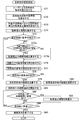
- FIG. 5 is a flowchart showing the procedure of the destination setting process. This process is executed by the control unit 14 shown in FIG. First, in step S71, the input operation receiving unit 20 receives the setting of the destination by the user. For example, the user sets the cleaning shop in front of the station as the destination in the input unit 12.
- step S72 the navigation processing unit 16 calculates the expected arrival time of the set destination.
- the estimated arrival time is calculated based on the distance of the recommended route to the destination, the degree of congestion of the road, and the like.
- step S73 the navigation processing unit 16 refers to the parking / stopping prohibition database 232 and acquires parking prohibition information around the destination at the estimated arrival time.
- step S74 the navigation processing unit 16 acquires map data around the destination with reference to the map database 231 and displays parking prohibition information around the destination on the map data.
- the roads r1 and r2 , R3 are displayed with symbols indicating parking prohibition, u1, u2, u3, u4.
- the road r1 is, for example, a two-lane road on one side, and the parking prohibition information may differ depending on the traveling direction. Therefore, the symbols u1 and u2 indicating parking prohibition are displayed in each direction. Since the roads r2 and r3 are one-lane roads on each side and the parking prohibition information is the same regardless of the traveling direction, one symbol u3 and u4 are displayed, respectively.
- parking prohibition it is also possible to distinguish between parking prohibition and parking prohibition. That is, it is also possible to acquire parking prohibition information and parking / stopping prohibition information from the parking / stopping prohibition database 232 and display them separately. For example, roads where parking is prohibited are displayed with a blue line, and roads where parking is prohibited are displayed with a red line to distinguish between the two.
- step S75 the parkable position search unit 18 determines whether or not parking is possible on the road around the destination Q1 based on the parking prohibition information. If parking is possible, the process proceeds to step S79, and if parking is not possible, the process proceeds to step S76. As shown in FIG. 7, when all the roads r1 to r3 around the destination Q1 are prohibited from parking, it is determined that parking is not possible.
- step S76 the display control unit 19 displays the parkable position in the area around the destination Q1. That is, as shown in FIG. 7, when all the roads (r1, r2, r3) around the destination Q1 are prohibited from parking, the user cannot park the vehicle on the roads around the destination Q1. Therefore, the parkingable position is displayed in the area around the destination Q1. Specifically, as shown in FIG. 7, the parking lot positions (reference numeral Q2), the toll parking lots p1, p2, and the like are displayed on the map data.
- the display control unit 19 emphasizes and displays the most recommended parkable position based on the priority condition set by the target user.
- the target user selects "priority is given to the distance to the destination" as the priority of the parkable position shown in the image D1 of FIG. 6, this user is as close to the destination as possible. Since it is determined that the driver wants a parking position, for example, as shown by reference numeral Q2 in FIG. 7, the position on the road closest to the destination Q1 and where parking is possible on the road (reference numeral Q2) is emphasized. indicate. Although the highlighting is shown by a dotted circle in FIG. 7 for convenience, it can be highlighted by using another method such as blinking display.
- step S77 the input operation reception unit 20 receives the necessity of changing the destination.
- the user accepts the selection of whether or not he / she wishes to change the destination.
- step S78 the display control unit 19 displays an image (not shown) prompting the selection of whether or not to change the destination on the display unit 13.
- the user does not input the change operation from the input unit 12.
- a desired parkable position is selected from a plurality of parkable positions (for example, Q2, p1, p2 shown in FIG. 7).
- step S79 the navigation processing unit 16 calculates the recommended route to the initial destination Q1.
- step S80 the navigation processing unit 16 sets the selected parkable position as a new destination. For example, when the code Q2 (road that can be parked on the street) shown in FIG. 7 is selected, the position of the code Q2 is set as a new destination, and the recommended route to this destination (code Q2) is calculated. To do.
- step S81 the navigation processing unit 16 starts route guidance to the set destination.
- step S82 the navigation processing unit 16 determines whether or not the estimated arrival time at the destination has changed according to the road congestion or the like. For example, when a change of 10 minutes (predetermined time) or more occurs from the initially set expected arrival time, it is determined that the change has occurred in the estimated arrival time.
- step S83 the display control unit 19 redisplays the parking prohibition information in step S83. That is, since the parking prohibition information may change depending on the time zone, when the parking prohibition information of the surrounding roads at the changed expected arrival time changes, this information can be notified to the user. After that, the process proceeds to step S84.
- step S84 the navigation processing unit 16 determines whether or not the vehicle has arrived at the destination based on the current position information of the vehicle acquired from the GPS receiving unit 11.
- step S85 the navigation processing unit 16 ends the route guidance. After that, this process ends.
- the toll parking lots p1, p2, and p4 are set as shown in FIG.
- the parking fee of each toll parking lot p1, p2, p4 is displayed. Specifically, "300 yen / h", “200 yen / h”, and “400 yen / h” are displayed for the toll parking lots p1, p2, and p4, respectively. Then, the cheapest toll parking lot p2 is highlighted.
- toll parking lots p1, p2, p4 Is displayed, and the vacancy rate of each toll parking lot p1, p2, p4 is displayed. Specifically, “10%”, “40%”, and “5%” are displayed for the toll parking lots p1, p2, and p4, respectively. Then, the toll parking lot p2 with the highest vacancy rate is highlighted.
- toll parking lots p1, p2, and p3 existing in the area around the destination Q1 are displayed. Further, the toll parking lots p1 and p2 are highlighted, and the toll parking lot p3 is not highlighted. That is, although the toll parking lot p3 is the closest to the destination Q1, it is considered that it is difficult to store the parking lot because it is necessary to pass through a narrow road in order to reach the toll parking lot p3. Do not show.
- the parkingable position (on the street or toll parking lot) is displayed as shown in FIGS. 7 to 12, and the parking lot with a high priority is emphasized. It is possible to prompt the user to select a parkingable position according to the priority condition of the user.
- the parking lot based on this priority is highlighted and displayed on the map data, for example. Will be done. Therefore, the user can immediately recognize the desired parking lot and set it as a new destination.
- the priority of the parkable position is set for each user, so even if the conditions of the place where each user wants to park are different, the parkable position suitable for each driver can be selected. It becomes possible to present. For example, if user A prefers a parkingable position close to the destination, and user B prefers a pay parking lot where parking is safe and secure, it is possible to present a parkingable position according to each preference. Become.
- the priority of the parkable position is set for one user according to the weather conditions or day and night, it is possible to present the parkable position according to the surrounding environmental conditions. For example, in rainy weather, it is possible to present a parking position as close to the destination as possible, and in fine weather, it is possible to present a toll parking lot where parking is safe and secure.
- parking prohibition information indicating a road where parking is prohibited or parking is prohibited on the road around the destination Q1 is displayed on the map data, it is easy for the user to create an area where parking is prohibited on the road around the destination Q1. It becomes possible to recognize.
- the navigation device 1 shown in FIG. 1 shows an example in which the control unit 14 is mounted, it is not necessary that all the functions or some functions of the control unit 14 are mounted on the navigation device 1.
- it can be configured to be provided in a server connected to the network 3.
- the functions constituting the navigation device 1 the GPS receiving unit 11, the display unit 13, the input unit 12, and the communication unit 15 may be mounted on the vehicle-side device or the smartphone.
- step S75a the parkable position search unit 18 performs a fixed time (for example, for example) from the expected arrival time at the destination Q1. Within 10 minutes), it is determined whether or not the parking prohibition on the roads around the destination Q1 will be lifted.
- the parking prohibition cancellation information can be obtained from the parking / stopping prohibition database 232 shown in FIG.
- step S75a If it is not released (S75a; NO), the process proceeds to step S76, and if it is released (S75a; YES), the process proceeds to step S75b.
- step S75b the display control unit 19 displays information on the display unit 13 indicating that the parking prohibition is lifted within a certain period of time. After that, the process proceeds to step S76.
- the user forcibly searches for an alternative parkingable position when the parking prohibition is lifted within 10 minutes (within a certain time) after the vehicle arrives at the destination Q1. If you don't, you can choose to wait until the parking ban is lifted.
- a navigation device capable of guiding a parkingable position suitable for a driver's request.
- Navigation device Base station server 3 Network 11 GPS receiver 12 Input unit 13 Display unit 14 Control unit 15 Communication unit 16 Navigation processing unit 17 Parking possible position presentation unit 18 Parking possible position search unit 19 Display control unit 20 Input operation reception unit 21 Parking position priority setting unit 22 Communication unit 23 Database 100 Route guidance system 161 Current position identification unit 162 Route guidance unit 163 Parking / stop prohibition information acquisition unit 211 Storage unit 231 Map database 232 Parking / stop prohibition database
Landscapes
- Engineering & Computer Science (AREA)
- Radar, Positioning & Navigation (AREA)
- Remote Sensing (AREA)
- Physics & Mathematics (AREA)
- Theoretical Computer Science (AREA)
- General Physics & Mathematics (AREA)
- Mathematical Physics (AREA)
- Automation & Control Theory (AREA)
- Business, Economics & Management (AREA)
- Educational Administration (AREA)
- Educational Technology (AREA)
- Navigation (AREA)
- Instructional Devices (AREA)
Abstract
目的地までの経路を案内する経路案内部(162)と、目的地への予想到着時刻において、目的地の周辺道路が駐車禁止または駐停車禁止であるか否かの情報である駐車・停車禁止情報を取得する駐車・停車禁止情報取得部(163)と、周辺道路が、予想到着時刻において、駐車禁止または駐停車禁止である場合に、周辺道路の周囲に設定した周囲エリアにおける駐車可能位置を検索する駐車可能位置検索部(18)を有する。更に、予め設定された駐車可能位置の条件の優先度に基づいて、複数の駐車可能位置を提示する駐車可能位置提示部(17)を有する。経路案内部(162)は、複数の駐車可能位置のうち、所望の駐車可能位置が選択された際に、所望の駐車可能位置に経路案内の目的地を変更する。
Description
本開示は、ナビゲーション装置、経路案内方法、及びコンピュータプログラムに関する。
例えば、駅周辺のクリーニング店、学習塾などは専用の駐車場を備えていないことが多い。また、車両を運転してクリーニング店で品物を受け取るときや学習塾で子供を迎えに行くときなどは、道路の路肩に短時間駐車することが多々あり得る。しかし、上記クリーニング店や学習塾などの目的地の周辺道路が駐車禁止である場合や、時間帯により駐車が規制されている場合には、運転者は目的地の周辺で車両を駐車できる場所、例えば路上駐車可能な道路や有料駐車場を探す必要がある。
特許文献1には、目的地と駐車可能道路との間の歩行の容易性の指標となる歩行コストが最も小さくなる駐車可能道路を探索することが開示されている。しかし、運転者によっては、歩行の容易性に限らず、例えば、料金を支払ったとしても安全に駐車できる駐車場に止めたいといった要望や、狭い道路や進入しにくい道路を走行することを避けたいという要望があり、特許文献1に開示された技術では、必ずしも運転者の要望に適した駐車可能位置を提供するものではない。
上述したように、特許文献1に開示された技術では、運転者の要望に適した駐車可能位置を提供することができないという問題があった。
本開示は、このような従来の課題を解決するためになされたものであり、その目的とするところは、運転者の要望に適した駐車可能位置を案内することが可能なナビゲーション装置、経路案内方法、及びコンピュータプログラムを提供することにある。
上記目的を達成するため、本開示の一態様に係るナビゲーション装置は、目的地までの経路を案内する経路案内部と、前記目的地への予想到着時刻において、前記目的地の周辺道路が駐車禁止または駐停車禁止であるか否かの情報である駐車・停車禁止情報を取得する駐車・停車禁止情報取得部と、前記周辺道路が、前記予想到着時刻において、駐車禁止または駐停車禁止である場合に、前記周辺道路の周囲に設定した周囲エリアにおける駐車可能位置を検索する駐車可能位置検索部と、を有し、予め設定された複数の駐車可能位置の条件の優先度に基づいて、所望の駐車可能位置を設定し、前記所望の駐車可能位置に経路案内の目的地を変更すること、を特徴とする。
本開示の一態様に係る経路案内方法は、目的地までの経路を案内するステップと、前記目的地への予想到着時刻において、前記目的地の周辺道路が駐車禁止または駐停車禁止であるか否かの情報である駐車・停車禁止情報を取得するステップと、前記周辺道路が、前記予想到着時刻において、駐車禁止または駐停車禁止である場合に、前記周辺道路の周囲に設定した周囲エリアにおける駐車可能位置を検索するステップと、予め設定された複数の駐車可能位置の条件の優先度に基づいて、所望の駐車可能位置を設定し、前記所望の駐車可能位置に経路案内の目的地を変更するステップと、を備えたことを特徴とする。
本開示の一態様に係るコンピュータプログラムは、目的地までの経路を案内するステップと、前記目的地への予想到着時刻において、前記目的地の周辺道路が駐車禁止または駐停車禁止であるか否かの情報である駐車・停車禁止情報を取得するステップと、前記周辺道路が、前記予想到着時刻において、駐車禁止または駐停車禁止である場合に、前記周辺道路の周囲に設定した周囲エリアにおける駐車可能位置を検索するステップと、予め設定された複数の駐車可能位置の条件の優先度に基づいて、所望の駐車可能位置を設定し、前記所望の駐車可能位置に経路案内の目的地を変更するステップと、をコンピュータに実行させることを特徴とする。
以下、本発明の実施形態を図面を参照して説明する。
[第1実施形態の説明]
図1は、本発明の実施形態に係るナビゲーション装置1を含む経路案内システム100の構成を示すブロック図である。
[第1実施形態の説明]
図1は、本発明の実施形態に係るナビゲーション装置1を含む経路案内システム100の構成を示すブロック図である。
図1に示すように、本実施形態に係る経路案内システム100は、車両に搭載されるか、或いは車両の乗員が携帯するナビゲーション装置1と、該ナビゲーション装置1との間でネットワーク3を介して通信が可能であり、車両から離れた基地局などに設けられる基地局サーバ2を備えている。
基地局サーバ2は、ネットワーク3を介してナビゲーション装置1と通信する通信部22と、データベース23を備えている。また、データベース23は、地図データベース231と、駐車・停車禁止データベース232を含んでいる。
地図データベース231は、経路案内用の地図データを記憶している。地図データには、一方通行、道路幅、通行規制などの情報が含まれている。更に、道路に面している有料駐車場の情報、及び駐車料金の情報が含まれている。
駐車・停車禁止データベース232は、地図データベース231に含まれる道路の路肩の駐車禁止、及び駐停車禁止を示すデータを記憶している。更に、時間帯により駐車或いは駐停車の可否が変更される場合には、時間帯に応じた駐車禁止或いは駐停車禁止を示すデータが記憶される。例えば、午前8時から午後5時までの時間帯が駐車禁止であり、それ以外の時間帯が駐車可能である道路の場合には、午前8時が駐車禁止に変更される時刻として記憶され、午後5時が駐車可能に変更される時刻として記憶される。
ナビゲーション装置1は、現在地或いは任意の位置を起点として、ユーザ(例えば、車両の運転者)が指定した目的地までの経路案内を行う装置であり、例えば、車両に搭載されている。或いは、ユーザが携行する端末装置(例えば、スマートフォン)などである。本実施形態では一例として、ナビゲーション装置1が車両に搭載される例について説明する。
ナビゲーション装置1は、GPS信号を受信するGPS受信部11と、入力部12と、表示部13と、制御部14と、通信部15を備えている。
通信部15は、ネットワーク3を介して基地局サーバ2との間で通信を行う。また、ネットワーク3を経由して、渋滞情報提供サービス(例えば、VICS(登録商標))、駐車場の空車情報提供サービス、駐車場の予約情報提供サービスより、渋滞情報、駐車場の空車情報、予約情報を取得する。
入力部12は、車両の乗員等のユーザが操作可能な端末機であり、各種のスイッチ、タッチパネル、音声入力器等を挙げることができる。
表示部13は、例えば液晶ディスプレイであり、目的地までの経路を含む各種の情報を表示する。更に、後述するように、検索した駐車可能位置、即ち、路上駐車可能な道路や有料駐車場を表示する。なお、表示部13の代わりに駐車可能位置の情報をインジケータ等で提示する構成としてもよい。また、入力部12と表示部13を兼用して、タッチパネルとすることも可能である。タッチパネルとは、液晶パネル等の表示装置とタッチパッド等の位置入力装置を組み合わせた電子部品である。
制御部14は、案内経路を探索するナビゲーション処理部16と、駐車可能位置提示部17と、駐車可能位置検索部18と、表示制御部19と、入力操作受付部20と、駐車位置優先度設定部21を備えている。
入力操作受付部20は、入力部12にて入力された操作指示を受け付ける。
表示制御部19は、表示部13に表示する画像を生成して表示部13に出力する。例えば、車両が現在地から目的地に向かう経路の地図画像、目的地の周辺で路上駐車が可能な道路の情報、有料駐車場の情報、などを表示する。なお、表示部13の代わりに目的地の位置をインジケータや音声で提示する構成としてもよい。
ナビゲーション処理部16は、現在位置特定部161と、経路案内部162と、駐車・停車禁止情報取得部163を備えている。
現在位置特定部161は、GPS受信部11で取得されたGPS情報に基づいて、車両の現在位置を特定する。なお、本実施形態では、GPS受信部11で取得されるGPS情報を用いる例について説明するが、ジャイロセンサなどの他の方法を用いて現在位置を特定することも可能である。
経路案内部162は、入力部12にて所望の目的地(例えば、駅前のクリーニング店)が設定された際に、地図データベース231に記憶されている地図データを参照し、この目的地までの推奨経路を演算する。また、目的地が変更された場合には、変更後の目的地までの推奨経路を再演算する。
駐車・停車禁止情報取得部163は、入力部12にて目的地が設定された際に、この目的地の周辺道路における駐車禁止情報、及び駐停車禁止情報を、駐車・停車禁止データベース232より取得する。「周辺道路」とは、目的地から所定距離の範囲内、例えば20m以内の道路である。
駐車位置優先度設定部21は、目的地の周辺に駐車可能な位置が存在しないときに、ユーザが希望する代替の駐車可能位置の情報を設定する。この情報は、ユーザが希望する条件の駐車する位置を入力部12より手動で入力することにより設定される。或いは、ユーザの走行履歴に基づいて自動的に設定される。
以下、ユーザが希望する条件を手動で設定する方法を、図6に示す表示例を参照して説明する。駐車位置優先度設定部21は、図6に示すようにユーザが希望する駐車する位置の条件の項目を示す画像D1を表示部13に表示し、ユーザによる選択を促す。
画像D1に示すように、優先度を示す条件として「目的地までの距離を優先」、「路上駐車を優先」、「パーキングを優先」、「入庫のし易さを優先」、「渋滞していない道路を優先」が表示される。ユーザは、これらの項目から所望する条件を選択する。なお、図6に示す条件は一例であり、その他の条件を表示することも可能である。
「目的地までの距離を優先」を選択すると、路上駐車、或いは有料駐車場(パーキング)を問わずに、駐車可能な位置のうち目的地に最も近い場所を高い優先度に設定することができる。少しでも目的地の近くに駐車したいというユーザにとって有用である。
「路上駐車を優先」を選択すると、目的地から所定距離の範囲内となる周囲エリア(例えば、500mの範囲内)において、路上駐車が可能な道路を高い優先度に設定することができる。多少遠くても駐車料金を支払いたくないというユーザにとって有用である。
「パーキングを優先」を選択すると、周囲エリアにおいて、有料駐車場を高い優先度に設定することができる。駐車料金を支払っても安全に且つ安心して駐車したいというユーザにとって有用である。更に、複数の有料駐車場が検索された場合には、加えて「空車率が高い」、「料金が安い」、「予約が可能である」などの条件を設定し、これらの条件に適合する有料駐車場を高い優先度に設定することも可能である。なお、空車率情報、及び予約情報は、前述した駐車場の空車情報提供サービス、駐車場の予約情報提供サービスより取得することができる。
「入庫のし易さを優先」を選択すると、周囲エリアにおいて、狭路やクランク路などの通行が困難な道路を通らずに入庫可能な有料駐車場、即ち、アクセスし易い駐車可能位置を高い優先度に設定することができる。狭路の通過や切り返しなどの操作が苦手なユーザにとって有用である。
「渋滞していない道路を優先」を選択すると、周囲エリア内において渋滞していない道路を経由して到達可能な駐車可能位置(路上、或いは有料駐車場)を高い優先度に設定することができる。即ち、駐車可能位置までの経路の混雑具合に応じて、できるだけ空いている道路を走行したいというユーザにとって有用である。なお、渋滞情報は、前述した渋滞情報提供サービスより取得することができる。
これらの駐車位置優先度の情報は、ユーザが複数存在する場合にはユーザ毎に設定され、図1に示す記憶部211に記憶される。優先度の条件は1つのみならず、第1優先、第2優先のように、複数設定することも可能である。この場合には、複数の各条件に優先度を設定し、優先度の高い順に検索して駐車可能位置を設定する。
また、優先度の条件それぞれに対しレベルを設定できるようにしても良い。例えば、各優先度の条件に対し5段階のレベルを設定し、「目的地までの距離を優先」を「5」、「路上駐車を優先」を「3」、「パーキングを優先」を「1」、「入庫のし易さを優先」を「2」、「渋滞していない道路を優先」を「2」などのように設定する。
また、優先度の条件それぞれに対しレベルを設定できるようにしても良い。例えば、各優先度の条件に対し5段階のレベルを設定し、「目的地までの距離を優先」を「5」、「路上駐車を優先」を「3」、「パーキングを優先」を「1」、「入庫のし易さを優先」を「2」、「渋滞していない道路を優先」を「2」などのように設定する。
更に、駐車位置優先度設定部21は、一人のユーザに対して周囲環境に応じて複数の優先度を設定することもできる。周囲環境とは、天候(晴天、雨天)、時間帯(昼間、夜間)などである。例えば、雨天時ではできるだけ目的地に近い駐車可能位置を希望する、或いは屋根付き駐車場を希望する等の条件を設定することができる。また、夜間は人通りの少ない道路は危険であるので、大通りの周囲の駐車場を希望するなどの条件を設定することができる。そして、設定された優先度の情報は記憶部211に記憶される。
また、前述したように、ユーザの走行履歴に基づいて駐車位置の優先度を自動設定することも可能である。例えば、過去の走行履歴に基づき、目的地からの距離に関わらず、道路の路肩に車両を駐車しているユーザについては、「路上駐車を優先」を高い優先度に設定する。一方、過去の走行履歴に基づき、目的地から近い位置に路上駐車可能な道路があるにも関わらず、有料駐車場に駐車しているユーザについては、「パーキングを優先」を高い優先順位に設定する。そして、上述した手動操作による設定と同様に、優先度の情報は記憶部211に記憶される。
図1に示す駐車可能位置検索部18は、入力部12にて設定された目的地(例えば、クリーニング店など)、及び駐車・停車禁止データベース232に記憶されている駐車禁止情報に基づいて、目的地の周辺(例えば、半径20m以内の範囲)に路上駐車可能な道路、或いは有料駐車場が存在するか否かを判断する。路上駐車可能な道路、或いは有料駐車場が存在しない場合には、目的地の周囲エリア(例えば、500mの範囲)で駐車可能な位置を検索する。「駐車可能な位置」とは、路上駐車が可能な道路や有料駐車場を指す。
具体的に、駐車可能位置検索部18は、地図データベース231を参照し、目的地の周囲500mの範囲で、路上駐車可能な道路、及び有料駐車場を検索する。
具体的に、駐車可能位置検索部18は、地図データベース231を参照し、目的地の周囲500mの範囲で、路上駐車可能な道路、及び有料駐車場を検索する。
駐車可能位置提示部17は、入力部12で設定された目的地の周辺道路が駐車禁止であり、目的地の周辺道路に車両を駐車できないと判断された際に、駐車可能位置検索部18で検索された駐車可能位置のうち、駐車位置優先度設定部21にて設定されている優先度の高い少なくとも一つの駐車可能位置を選択する。更に、選択した駐車可能位置の情報を含む地図データを、表示部13に表示する。
表示部13に表示された駐車可能位置の情報に基づいて、ユーザが所望の駐車可能位置を選択すると、この駐車可能位置が新たな目的地として設定され、経路案内部162により、新たな目的地までの推奨経路が演算され、この推奨経路を表示部13に表示する。
なお、本実施形態に係る制御部14は、ハードウエア的には、任意のコンピュータのCPU、メモリ、その他のLSIで実現でき、ソフトウエア的にはメモリにロードされたプログラムなどによって実現される。ここではそれらの連携によって実現される機能ブロックを描いている。従って、これらの機能ブロックがハードウエアのみ、ソフトウエアのみ、またはそれらの組合せによっていろいろな形で実現できることは、当業者には理解されるところである。
[第1実施形態の作用の説明]
次に、上述のように構成された本実施形態に係るナビゲーション装置1の処理手順について図2~図5に示すフローチャートを参照して説明する。
次に、上述のように構成された本実施形態に係るナビゲーション装置1の処理手順について図2~図5に示すフローチャートを参照して説明する。
図2は、駐車可能位置の優先度を設定する処理の第1の手順を示すフローチャートである。初めにステップS11において、駐車位置優先度設定部21は、表示部13に優先度のリストを表示する。具体的に、図6の画像D1に示したように、駐車場を選択する際の複数の条件を表示する。
ステップS12において、駐車位置優先度設定部21は、ユーザによる選択入力の操作を受け付ける。この処理により、例えば「目的地までの距離を優先」などの少なくとも一つの条件が入力される。
ステップS13において、駐車位置優先度設定部21は、選択された優先度の条件を記憶部211に記憶する。その後、本処理を終了する。このように、第1の手順では、ユーザの好みに応じた駐車可能位置の優先度が設定され、記憶部211に記憶されることになる。
図3は、駐車可能位置の優先度を設定する処理の第2の手順を示すフローチャートである。図3に示す例では、同一のユーザに対して、天候(周囲環境)に応じて2つの優先度を設定する。具体的に、晴天時と雨天時でそれぞれ異なる優先度を設定する。以下、詳細に説明する。
図3のステップS31において、駐車位置優先度設定部21は、表示部13に晴天時における優先度のリストを表示する。具体的に、図6の画像D1に示したように、駐車場を選択する際の複数の条件を表示する。
ステップS32において、駐車位置優先度設定部21は、ユーザによる選択入力の操作を受け付ける。この処理により、例えば「パーキングを優先」などの少なくとも一つの条件が入力される。
ステップS33において、駐車位置優先度設定部21は、選択された優先度の条件を晴天時における条件として記憶部211に記憶する。
その後、ステップS34において、駐車位置優先度設定部21は、表示部13に雨天時における優先度のリストを表示する。具体的に、図6の画像D1に示したように、駐車場を選択する際の複数の条件を表示する。
ステップS35において、駐車位置優先度設定部21は、ユーザによる選択入力の操作を受け付ける。この処理により、例えば「目的地までの距離を優先」などの少なくとも一つの条件が入力される。
ステップS36において、駐車位置優先度設定部21は、選択された優先度の条件を雨天時における条件として記憶部211に記憶する。その後、本処理を終了する。
このように、第2の手順では、天候が晴天の場合、及び雨天の場合で、それぞれユーザの好みに応じた駐車可能位置の優先度が設定され、記憶部211に記憶されることになる。
図4は、駐車可能位置の優先度を設定する処理の第3の手順を示すフローチャートである。図4に示す例では、同一のユーザに対して、時間帯(周囲環境)に応じて2つの優先度を設定する。具体的に、昼間と夜間でそれぞれ異なる優先度を設定する。以下、詳細に説明する。
図4のステップS51において、駐車位置優先度設定部21は、表示部13に昼間における優先度のリストを表示する。具体的に、図6の画像D1に示したように、駐車場を選択する際の複数の条件を表示する。
ステップS52において、駐車位置優先度設定部21は、ユーザによる選択入力の操作を受け付ける。
ステップS53において、駐車位置優先度設定部21は、選択された優先度の条件を昼間における条件として記憶部211に記憶する。
その後、ステップS54において、駐車位置優先度設定部21は、表示部13に夜間における優先度のリストを表示する。
ステップS55において、駐車位置優先度設定部21は、ユーザによる選択入力の操作を受け付ける。
ステップS56において、駐車位置優先度設定部21は、選択された優先度の条件を夜間における条件として記憶部211に記憶する。その後、本処理を終了する。
このように、第3の手順では、時間帯が昼間の場合、及び夜間の場合で、それぞれユーザの好みに応じた駐車可能位置の優先度が設定され、記憶部211に記憶されることになる。
なお、図2~図4ではユーザの選択入力、即ち手動入力にて優先度の条件を設定する例について示したが、前述したように、ユーザが過去に走行した走行履歴に基づいて、優先度の条件を自動で設定することも可能である。
次に、目的地の設定処理について説明する。図5は、目的地の設定処理の手順を示すフローチャートである。この処理は、図1に示す制御部14により実行される。初めに、ステップS71において、入力操作受付部20は、ユーザによる目的地の設定を受け付ける。例えば、ユーザは入力部12において駅前のクリーニング店を目的地として設定する。
ステップS72において、ナビゲーション処理部16は、設定された目的地の予想到着時刻を算出する。この処理では、目的地までの推奨経路の距離、及び道路の混雑度などに基づいて、予想到着時刻を算出する。
ステップS73において、ナビゲーション処理部16は、駐車・停車禁止データベース232を参照し、予想到着時刻における目的地周辺の駐車禁止情報を取得する。
ステップS74において、ナビゲーション処理部16は、地図データベース231を参照して目的地周辺の地図データを取得し、且つ、目的地周辺における駐車禁止情報を地図データ上に表示する。例えば、図7に示すように地図データ上に、駅T1付近の目的地Q1が表示され、該目的地Q1の周辺に路上駐車が禁止されている道路がある場合には、この道路r1、r2、r3に駐車禁止を示す記号、u1、u2、u3、u4を表示する。なお、道路r1は例えば片側二車線道路であり、走行方向によって駐車禁止の情報が異なることがあるので、それぞれの方向ごとに駐車禁止を示す記号u1、u2を表示している。道路r2、r3は、片側一車線道路であり走行方向に関わらず駐車禁止の情報は同一であるので、それぞれ一つの記号u3、u4を表示している。
これらの記号u1~u4は、線の種類、或いは色を適宜設定することにより、ユーザが認識し易い態様で表示する。ユーザはこの表示を見ることにより、目的地Q1の周辺道路に車両を駐車できないことを認識できる。
なお、駐車禁止と駐停車禁止を区別して表示することも可能である。即ち、駐車・停車禁止データベース232より、駐車禁止情報、及び駐停車禁止情報を取得し、これらを区別して表示することも可能である。例えば、駐車禁止の道路は青色、駐停車禁止の道路は赤色の線で表示することにより、両者を区別することができる。
ステップS75において、駐車可能位置検索部18は、駐車禁止情報に基づいて、目的地Q1の周囲道路に駐車可能であるか否かを判断する。駐車可能であればステップS79に処理を進め、駐車不可であればステップS76に処理を進める。図7に示すように目的地Q1の周辺道路r1~r3がすべて駐車禁止である場合には、駐車不可であると判断する。
ステップS76において、表示制御部19は、目的地Q1の周囲エリアにおける駐車可能位置を表示する。即ち、図7に示したように、目的地Q1の周辺道路(r1、r2、r3)が全て駐車禁止である場合には、ユーザは目的地Q1の周辺道路に車両を駐車することができない。従って、目的地Q1の周囲エリアにおいて駐車可能位置を表示する。具体的に、図7に示すように、地図データ上に路上駐車可能な位置(符号Q2)、有料駐車場p1、p2などの駐車可能位置を表示する。
更に、表示制御部19は、対象となるユーザにより設定された優先度の条件に基づいて、最も推奨する駐車可能位置を強調して表示する。
例えば、対象となるユーザが、図6の画像D1に示した駐車可能位置の優先度として、「目的地までの距離を優先」を選択している場合には、このユーザはできるだけ目的地に近くて駐車可能な位置を望んでいると判断されるので、例えば、図7の符号Q2のように、目的地Q1に最も近く、且つ路上駐車可能な道路上の位置(符号Q2)を強調して表示する。なお、図7では強調表示を便宜上点線の円で示しているが、点滅表示など他の手法を用いて強調表示することも可能である。
ステップS77において、入力操作受付部20は、目的地の変更の要否を受け付ける。この処理では、目的地Q1の周辺道路が駐車禁止であることをユーザに通知した上で、ユーザが目的地の変更を希望するか否かの選択を受け付ける。
ステップS78において、表示制御部19は、目的地を変更するか否かの選択を促す画像(図示省略)を表示部13に表示する。ユーザは、目的地を変更する必要がないと考える場合には、入力部12より変更操作を入力しない。一方、目的地を変更する必要があると考える場合には、変更操作を入力する。この際、複数の駐車可能位置(例えば、図7に示したQ2、p1、p2)のうち、所望の駐車可能位置を選択する。
目的地の変更操作が行われない場合には(S78;NO)、ステップS79において、ナビゲーション処理部16は、当初の目的地Q1までの推奨経路を演算する。
目的地の変更操作が行われた場合には(S78;YES)、ステップS80において、ナビゲーション処理部16は、選択された駐車可能位置を新たな目的地として設定する。例えば、図7に示す符号Q2(路上駐車可能な道路)が選択された場合には、この符号Q2の位置を新たな目的地に設定し、この目的地(符号Q2)までの推奨経路を演算する。
ステップS81において、ナビゲーション処理部16は、設定されている目的地までの経路案内を開始する。
ステップS82において、ナビゲーション処理部16は、道路の混雑状況などに応じて、目的地への予想到着時刻に変更が発生したか否かを判断する。例えば、当初設定した予想到着時刻に対して、10分(所定時間)以上の変更が発生した場合に、予想到着時刻に変更が発生したものと判断する。
予想到着時刻に変更が発生した場合には(S82;YES)、ステップS83において、表示制御部19は、駐車禁止情報を再表示する。即ち、駐車禁止情報は時間帯により変化することがあるので、変更後の予想到着時刻における周辺道路の駐車禁止情報に変化が発生した場合には、この情報をユーザに知らせることができる。その後、ステップS84に処理を進める。
ステップS84において、ナビゲーション処理部16は、GPS受信部11より取得される車両の現在位置情報に基づいて、車両が目的地に到着したか否かを判断する。
車両が目的地に到着した場合には(S84;YES)、ステップS85において、ナビゲーション処理部16は、経路案内を終了する。その後、本処理を終了する。
また、上記した実施形態では、ユーザが駐車可能位置を選択する際の条件として「目的地までの距離を優先」を設定した例について説明した。
以下に、「路上駐車を優先」、「パーキングを優先」、「入庫のしやすさを優先」、「渋滞していない道路を優先」の各項目の優先度が高く設定されている場合、即ち、図2のS13、図3のS33、S36、図4のS53、S56の処理で各種の条件が高い優先度として記憶されている場合の、表示例について説明する。
「路上駐車を優先」が設定されている場合には、図7に示したように路上駐車可能な道路の位置を示す符号Q2を強調して地図上に表示する。
「パーキングを優先」が設定されている場合には、図8に示すように、目的地Q1の周囲エリア(例えば、500mの範囲内)に存在する有料駐車場p1、p2のうち、目的地Q1に近い有料駐車場p1を強調して地図上に表示する。
また、「パーキングを優先」が設定されており、更に「料金が安い」(図6では図示省略)が設定された場合には、図9に示すように、有料駐車場p1、p2、p4を表示すると共に、各有料駐車場p1、p2、p4の駐車料金を表示する。具体的に、有料駐車場p1、p2、p4に対してそれぞれ、「300円/h」、「200円/h」、「400円/h」が表示される。そして、最も料金の安い有料駐車場p2を強調表示する。
更に、「パーキングを優先」が設定されており、更に「空車率が高い」(図6では図示省略)が設定された場合には、図10に示すように、有料駐車場p1、p2、p4を表示すると共に、各有料駐車場p1、p2、p4の空車率を表示する。具体的に、有料駐車場p1、p2、p4に対してそれぞれ、「10%」、「40%」、「5%」が表示される。そして、最も空車率の高い有料駐車場p2を強調表示する。
「入庫のしやすさを優先」が設定されている場合には、図11に示すように、目的地Q1の周囲エリアに存在する有料駐車場p1、p2、p3を表示する。更に、有料駐車場p1、p2を強調表示し、有料駐車場p3は強調表示しない。即ち、有料駐車場p3は目的地Q1から最も近い位置にあるが、有料駐車場p3に到達するためには、狭路を通過する必要があり入庫しにくいと考えられるので、推奨位置とせず強調表示しない。
「渋滞していない道路を優先」が設定されている場合には、図12に示すように、道路の渋滞情報を表示し、且つ、目的地Q1の周囲エリアに存在する有料駐車場p1、p2を表示する。そして、渋滞している道路を走行せずに到達可能な有料駐車場p2を強調表示する。
そして、ユーザが設定した優先度の条件に応じて、図7~図12のように、駐車可能な位置(路上或いは有料駐車場)を表示し、更に、優先度の高い駐車可能位置を強調して表示することにより、ユーザの優先度の条件に応じた駐車可能位置の選択を促すことができるのである。
[第1実施形態の効果の説明]
このようにして、第1実施形態に係るナビゲーション装置1では、目的地Q1の周辺道路に駐車可能な場所がない場合には、目的地の周囲エリア内(例えば、500m以内)で駐車可能な位置を提示する。そして、所望の駐車可能位置が選択された際にはこの駐車可能位置を新たに目的地に設定して経路案内を行う。従って、ユーザは所望の駐車可能位置に直接行くことができるので、従来のように目的地Q1の近くまで行った後に周辺の駐車場を探すという煩わしさを回避することができる。
このようにして、第1実施形態に係るナビゲーション装置1では、目的地Q1の周辺道路に駐車可能な場所がない場合には、目的地の周囲エリア内(例えば、500m以内)で駐車可能な位置を提示する。そして、所望の駐車可能位置が選択された際にはこの駐車可能位置を新たに目的地に設定して経路案内を行う。従って、ユーザは所望の駐車可能位置に直接行くことができるので、従来のように目的地Q1の近くまで行った後に周辺の駐車場を探すという煩わしさを回避することができる。
また、ユーザは、自身が駐車したい場所を示す優先度を予め設定するので、代替の駐車場を提示する際には、この優先度に基づいた駐車場が、例えば地図データ上に強調して表示されることになる。従って、ユーザは所望する駐車場を即時に認識して、新たな目的地に設定することが可能となる。
更に、複数のユーザが存在する場合には、ユーザ毎に駐車可能位置の優先度が設定されるので、各ユーザで駐車したい場所の条件が異なる場合でも、各運転者に適した駐車可能位置を提示することが可能となる。例えば、ユーザAは目的地に近い駐車可能位置を好み、ユーザBは安全で且つ安心して駐車できる有料駐車場を好む場合には、それぞれの好みに応じた駐車可能位置を提示することが可能となる。
また、一人のユーザに対して、天候状況、或いは昼夜の別に応じて駐車可能位置の優先度を設定するので、周囲の環境状況に応じた駐車可能位置を提示することが可能となる。例えば、雨天時には、できるだけ目的地に近い駐車可能位置を提示し、晴天時には安全で且つ安心して駐車できる有料駐車場を提示することが可能となる。
更に、目的地Q1の周囲道路において駐車禁止、或いは駐停車禁止の道路を示す駐車禁止情報を地図データ上に表示するので、ユーザに対して目的地Q1の周囲道路の駐車禁止となるエリアを容易に認識することが可能となる。
なお、上述した第1実施形態では、車両に搭載されるナビゲーション装置1による処理について説明したが、例えば、ユーザが携行するスマートフォンのアプリケーションとして登録されているナビゲーション機能を用いることも可能である。
また、図1に示したナビゲーション装置1は、制御部14を搭載する例について示しているが、制御部14の全ての機能、或いは一部の機能はナビゲーション装置1に搭載されている必要はなく、例えばネットワーク3に接続されたサーバなどに設けられる構成とすることも可能である。ナビゲーション装置1を構成する機能のうち、GPS受信部11、表示部13、入力部12、及び通信部15が車両側装置或いはスマートフォンに搭載されていればよい。
[第2実施形態の説明]
次に、本発明の第2実施形態について説明する。第2実施形態に係るナビゲーション装置は、前述した図1と同様であるので構成の説明を省略する。第2実施形態では、図5に示した目的地の設定処理が前述した第1実施形態と相違する。
次に、本発明の第2実施形態について説明する。第2実施形態に係るナビゲーション装置は、前述した図1と同様であるので構成の説明を省略する。第2実施形態では、図5に示した目的地の設定処理が前述した第1実施形態と相違する。
以下、図13に示すフローチャートを参照して、第2実施形態に係るナビゲーション装置における目的地設定処理について説明する。
図13に示すS71~S75は、図5に示したS71~S75と同一であり、図13に示すS76~85は、図5に示したS76~S85と同一である。第2実施形態では、ステップS75a、S75bの処理を追加している点で前述した第1実施形態と相違する。以下、詳細に説明する。
図13に示すS71~S75は、図5に示したS71~S75と同一であり、図13に示すS76~85は、図5に示したS76~S85と同一である。第2実施形態では、ステップS75a、S75bの処理を追加している点で前述した第1実施形態と相違する。以下、詳細に説明する。
ステップS75において、目的地Q1の周辺道路に駐車可能でないと判断されると(S75;NO)、ステップS75aにおいて、駐車可能位置検索部18は、目的地Q1への予想到着時刻から一定時間(例えば、10分間)以内に、目的地Q1の周辺道路の駐車禁止が解除されるか否かを判断する。駐車禁止の解除情報は、図1に示す駐車・停車禁止データベース232より取得することができる。
解除されない場合には(S75a;NO)、ステップS76に処理を進め、解除される場合には(S75a;YES)、ステップS75bに処理を進める。
ステップS75bにおいて、表示制御部19は、一定時間以内に駐車禁止が解除されることを示す旨の情報を表示部13に表示する。その後、ステップS76に処理を進める。
そして、第2実施形態では、ユーザは車両が目的地Q1に到着した後に、例えば10分以内(一定時間以内)に駐車禁止が解除される場合には、無理に代替となる駐車可能位置を検索しなくても、駐車禁止が解除されるまで待つことを選択できる。
即ち、第2実施形態に係るナビゲーション装置では、少しの待ち時間で駐車禁止が解除されるような場合には、この情報をユーザに提示することにより、代替の駐車可能位置を選択することに加えて、駐車禁止が解除されるまで待つことを選択することが可能になる。
特願2019-121125号(出願日:2019年6月28日)の全内容は、ここに援用される。
以上、本発明の実施形態を記載したが、この開示の一部をなす論述及び図面はこの発明を限定するものであると理解すべきではない。この開示から当業者には様々な代替実施の形態、実施例及び運用技術が明らかとなろう。
本開示によれば、運転者の要望に適した駐車可能位置を案内することが可能なナビゲーション装置、経路案内方法、及びコンピュータプログラムを提供することができる。
1 ナビゲーション装置
2 基地局サーバ
3 ネットワーク
11 GPS受信部
12 入力部
13 表示部
14 制御部
15 通信部
16 ナビゲーション処理部
17 駐車可能位置提示部
18 駐車可能位置検索部
19 表示制御部
20 入力操作受付部
21 駐車位置優先度設定部
22 通信部
23 データベース
100 経路案内システム
161 現在位置特定部
162 経路案内部
163 駐車・停車禁止情報取得部
211 記憶部
231 地図データベース
232 駐車・停車禁止データベース
2 基地局サーバ
3 ネットワーク
11 GPS受信部
12 入力部
13 表示部
14 制御部
15 通信部
16 ナビゲーション処理部
17 駐車可能位置提示部
18 駐車可能位置検索部
19 表示制御部
20 入力操作受付部
21 駐車位置優先度設定部
22 通信部
23 データベース
100 経路案内システム
161 現在位置特定部
162 経路案内部
163 駐車・停車禁止情報取得部
211 記憶部
231 地図データベース
232 駐車・停車禁止データベース
Claims (10)
- 目的地までの経路を案内する経路案内部と、
前記目的地への予想到着時刻において、前記目的地の周辺道路が駐車禁止または駐停車禁止であるか否かの情報である駐車・停車禁止情報を取得する駐車・停車禁止情報取得部と、
前記周辺道路が、前記予想到着時刻において、駐車禁止または駐停車禁止である場合に、前記周辺道路の周囲に設定した周囲エリアにおける駐車可能位置を検索する駐車可能位置検索部と、を有し、
予め設定された複数の駐車可能位置の条件の優先度に基づいて所望の駐車可能位置を設定し、前記所望の駐車可能位置に経路案内の目的地を変更すること、
を特徴とするナビゲーション装置。 - 前記優先度は、ユーザによる選択入力により設定されること
を特徴とする請求項1に記載のナビゲーション装置。 - 前記ユーザは複数存在し、前記優先度はユーザごとに設定されること
を特徴とする請求項1または2に記載のナビゲーション装置。 - 前記優先度は、一人の運転者に対し、複数設定すること
を特徴とする請求項1~3のいずれか1項に記載のナビゲーション装置。 - 前記駐車・停車禁止情報に基づき、前記予想到着時刻の後に、一定時間以内に前記周辺道路の駐車禁止または駐停車禁止が解除されると認識された場合に、一定時間以内に前記周辺道路の駐車禁止または駐停車禁止が解除されることを示す情報を提示する駐車可能位置提示部を更に備えたこと
を特徴とする請求項1~4のいずれか1項に記載のナビゲーション装置。 - 前記経路案内部は、前記目的地の周辺道路が駐車禁止、或いは駐停車禁止である場合には、地図データ上の駐車禁止、及び駐停車禁止である道路を示す駐車禁止情報及び駐停車禁止情報を表示すること
を特徴とする請求項1~5のいずれか1項に記載のナビゲーション装置。 - 前記駐車可能位置の優先度は、下記(1)~(5)の少なくとも一つの条件に基づいて設定されることを特徴とする請求項1~6のいずれか1項に記載のナビゲーション装置。(1)前記目的地から近い(2)駐車料金が安い駐車場(3)駐車可能位置までのアクセスし易さ(4)駐車可能位置までの経路の混雑具合(5)空車率が高い駐車場
- 前記経路案内部は、目的地への予想到着時刻が所定時間以上変更された際には、再度駐車可能位置の設定を実施すること
を特徴とする請求項1~7のいずれか1項に記載のナビゲーション装置。 - 目的地までの経路を案内するステップと、
前記目的地への予想到着時刻において、前記目的地の周辺道路が駐車禁止または駐停車禁止であるか否かの情報である駐車・停車禁止情報を取得するステップと、
前記周辺道路が、前記予想到着時刻において、駐車禁止または駐停車禁止である場合に、前記周辺道路の周囲に設定した周囲エリアにおける駐車可能位置を検索するステップと、
予め設定された複数の駐車可能位置の条件の優先度に基づいて、所望の駐車可能位置を設定し、前記所望の駐車可能位置に経路案内の目的地を変更するステップと、
を備えたことを特徴とする経路案内方法。 - 目的地までの経路を案内するステップと、
前記目的地への予想到着時刻において、前記目的地の周辺道路が駐車禁止または駐停車禁止であるか否かの情報である駐車・停車禁止情報を取得するステップと、
前記周辺道路が、前記予想到着時刻において、駐車禁止または駐停車禁止である場合に、前記周辺道路の周囲に設定した周囲エリアにおける駐車可能位置を検索するステップと、
予め設定された複数の駐車可能位置の条件の優先度に基づいて、所望の駐車可能位置を設定し、前記所望の駐車可能位置に経路案内の目的地を変更するステップと、
をコンピュータに実行させることを特徴とするコンピュータプログラム。
Applications Claiming Priority (2)
| Application Number | Priority Date | Filing Date | Title |
|---|---|---|---|
| JP2019-121125 | 2019-06-28 | ||
| JP2019121125A JP2021006798A (ja) | 2019-06-28 | 2019-06-28 | ナビゲーション装置、経路案内方法、及びコンピュータプログラム |
Publications (1)
| Publication Number | Publication Date |
|---|---|
| WO2020261697A1 true WO2020261697A1 (ja) | 2020-12-30 |
Family
ID=74061604
Family Applications (1)
| Application Number | Title | Priority Date | Filing Date |
|---|---|---|---|
| PCT/JP2020/015342 Ceased WO2020261697A1 (ja) | 2019-06-28 | 2020-04-03 | ナビゲーション装置、経路案内方法、及びコンピュータプログラム |
Country Status (2)
| Country | Link |
|---|---|
| JP (1) | JP2021006798A (ja) |
| WO (1) | WO2020261697A1 (ja) |
Cited By (1)
| Publication number | Priority date | Publication date | Assignee | Title |
|---|---|---|---|---|
| CN112652192A (zh) * | 2021-01-04 | 2021-04-13 | 北京嘀嘀无限科技发展有限公司 | 确定限制停靠位置的方法、装置、设备、介质和程序产品 |
Citations (5)
| Publication number | Priority date | Publication date | Assignee | Title |
|---|---|---|---|---|
| JP2002090162A (ja) * | 2000-09-13 | 2002-03-27 | Hitachi Ltd | 端末装置 |
| JP2009162567A (ja) * | 2007-12-28 | 2009-07-23 | Aisin Aw Co Ltd | ナビゲーション装置及びコンピュータプログラム |
| WO2010109762A1 (ja) * | 2009-03-25 | 2010-09-30 | 株式会社トヨタマップマスター | ナビゲーションシステム、ナビゲーション方法、ナビゲーション方法を実行するためのコンピュータプログラム及びそのコンピュータプログラムを記録した記録媒体 |
| JP2017228259A (ja) * | 2016-06-25 | 2017-12-28 | Ihi運搬機械株式会社 | パーキングサーバの運用方法と電気通信機器用ソフトウエア |
| JP2018163039A (ja) * | 2017-03-27 | 2018-10-18 | パイオニア株式会社 | 情報処理装置、情報処理方法、および、情報処理用プログラム |
-
2019
- 2019-06-28 JP JP2019121125A patent/JP2021006798A/ja not_active Abandoned
-
2020
- 2020-04-03 WO PCT/JP2020/015342 patent/WO2020261697A1/ja not_active Ceased
Patent Citations (5)
| Publication number | Priority date | Publication date | Assignee | Title |
|---|---|---|---|---|
| JP2002090162A (ja) * | 2000-09-13 | 2002-03-27 | Hitachi Ltd | 端末装置 |
| JP2009162567A (ja) * | 2007-12-28 | 2009-07-23 | Aisin Aw Co Ltd | ナビゲーション装置及びコンピュータプログラム |
| WO2010109762A1 (ja) * | 2009-03-25 | 2010-09-30 | 株式会社トヨタマップマスター | ナビゲーションシステム、ナビゲーション方法、ナビゲーション方法を実行するためのコンピュータプログラム及びそのコンピュータプログラムを記録した記録媒体 |
| JP2017228259A (ja) * | 2016-06-25 | 2017-12-28 | Ihi運搬機械株式会社 | パーキングサーバの運用方法と電気通信機器用ソフトウエア |
| JP2018163039A (ja) * | 2017-03-27 | 2018-10-18 | パイオニア株式会社 | 情報処理装置、情報処理方法、および、情報処理用プログラム |
Cited By (1)
| Publication number | Priority date | Publication date | Assignee | Title |
|---|---|---|---|---|
| CN112652192A (zh) * | 2021-01-04 | 2021-04-13 | 北京嘀嘀无限科技发展有限公司 | 确定限制停靠位置的方法、装置、设备、介质和程序产品 |
Also Published As
| Publication number | Publication date |
|---|---|
| JP2021006798A (ja) | 2021-01-21 |
Similar Documents
| Publication | Publication Date | Title |
|---|---|---|
| US9026351B2 (en) | Navigation devices, methods and programs | |
| US11326895B2 (en) | Methods and systems of providing information using a navigation apparatus | |
| EP3702979A1 (en) | Information processing device, information processing method and information processing program | |
| CN113570894B (zh) | 自动驾驶辅助装置、控制方法及存储介质 | |
| EP2616775B1 (en) | Navigation device with alternative navigation instructions | |
| JP4094246B2 (ja) | 車載用ナビゲーション装置 | |
| US20130317745A1 (en) | Navigation device | |
| US20090171567A1 (en) | Navigation devices, methods and programs | |
| EP2075542A2 (en) | Multi-screen display device and program of the same | |
| US20090171563A1 (en) | Navigation devices, methods and programs | |
| CA3054776A1 (en) | Dynamic display of route preview information | |
| CN107452226B (zh) | 一种中途停车推荐路侧停车位的方法及系统 | |
| US11079247B2 (en) | Method for assisting a user of a motor vehicle when driving the motor vehicle, navigation apparatus and motor vehicle | |
| JP2009014536A (ja) | ナビゲーション装置および周辺駐車場案内方法 | |
| JP4115888B2 (ja) | 端末装置、及び駐車場情報提供システム | |
| JP2004226312A (ja) | 車両用ナビゲーション装置及びプログラム | |
| JP2002243471A (ja) | 車載用ナビゲーション装置 | |
| JP2005147708A (ja) | ナビゲーションシステム及び方法 | |
| WO2020261697A1 (ja) | ナビゲーション装置、経路案内方法、及びコンピュータプログラム | |
| JP2006184231A (ja) | 車両用ナビゲーション装置 | |
| JP5012123B2 (ja) | ナビゲーション装置、制御方法及びプログラム | |
| JP2017227445A (ja) | 自動運転装置 | |
| JP2002365066A (ja) | ナビゲーション用交通情報受信装置 | |
| JP6646783B2 (ja) | 移動体の配置システム | |
| JP2006047266A (ja) | 車両用ナビゲーション装置 |
Legal Events
| Date | Code | Title | Description |
|---|---|---|---|
| 121 | Ep: the epo has been informed by wipo that ep was designated in this application |
Ref document number: 20831157 Country of ref document: EP Kind code of ref document: A1 |
|
| NENP | Non-entry into the national phase |
Ref country code: DE |
|
| 122 | Ep: pct application non-entry in european phase |
Ref document number: 20831157 Country of ref document: EP Kind code of ref document: A1 |