WO2020110792A1 - 車両制御システム及び地図データ管理装置 - Google Patents
車両制御システム及び地図データ管理装置 Download PDFInfo
- Publication number
- WO2020110792A1 WO2020110792A1 PCT/JP2019/045008 JP2019045008W WO2020110792A1 WO 2020110792 A1 WO2020110792 A1 WO 2020110792A1 JP 2019045008 W JP2019045008 W JP 2019045008W WO 2020110792 A1 WO2020110792 A1 WO 2020110792A1
- Authority
- WO
- WIPO (PCT)
- Prior art keywords
- map data
- vehicle
- traveling
- road
- information
- Prior art date
- Legal status (The legal status is an assumption and is not a legal conclusion. Google has not performed a legal analysis and makes no representation as to the accuracy of the status listed.)
- Ceased
Links
Images




Classifications
-
- B—PERFORMING OPERATIONS; TRANSPORTING
- B60—VEHICLES IN GENERAL
- B60W—CONJOINT CONTROL OF VEHICLE SUB-UNITS OF DIFFERENT TYPE OR DIFFERENT FUNCTION; CONTROL SYSTEMS SPECIALLY ADAPTED FOR HYBRID VEHICLES; ROAD VEHICLE DRIVE CONTROL SYSTEMS FOR PURPOSES NOT RELATED TO THE CONTROL OF A PARTICULAR SUB-UNIT
- B60W30/00—Purposes of road vehicle drive control systems not related to the control of a particular sub-unit, e.g. of systems using conjoint control of vehicle sub-units
-
- B—PERFORMING OPERATIONS; TRANSPORTING
- B60—VEHICLES IN GENERAL
- B60W—CONJOINT CONTROL OF VEHICLE SUB-UNITS OF DIFFERENT TYPE OR DIFFERENT FUNCTION; CONTROL SYSTEMS SPECIALLY ADAPTED FOR HYBRID VEHICLES; ROAD VEHICLE DRIVE CONTROL SYSTEMS FOR PURPOSES NOT RELATED TO THE CONTROL OF A PARTICULAR SUB-UNIT
- B60W60/00—Drive control systems specially adapted for autonomous road vehicles
-
- G—PHYSICS
- G01—MEASURING; TESTING
- G01C—MEASURING DISTANCES, LEVELS OR BEARINGS; SURVEYING; NAVIGATION; GYROSCOPIC INSTRUMENTS; PHOTOGRAMMETRY OR VIDEOGRAMMETRY
- G01C21/00—Navigation; Navigational instruments not provided for in groups G01C1/00 - G01C19/00
- G01C21/26—Navigation; Navigational instruments not provided for in groups G01C1/00 - G01C19/00 specially adapted for navigation in a road network
- G01C21/34—Route searching; Route guidance
-
- G—PHYSICS
- G08—SIGNALLING
- G08G—TRAFFIC CONTROL SYSTEMS
- G08G1/00—Traffic control systems for road vehicles
-
- G—PHYSICS
- G08—SIGNALLING
- G08G—TRAFFIC CONTROL SYSTEMS
- G08G1/00—Traffic control systems for road vehicles
- G08G1/09—Arrangements for giving variable traffic instructions
-
- G—PHYSICS
- G08—SIGNALLING
- G08G—TRAFFIC CONTROL SYSTEMS
- G08G1/00—Traffic control systems for road vehicles
- G08G1/09—Arrangements for giving variable traffic instructions
- G08G1/0962—Arrangements for giving variable traffic instructions having an indicator mounted inside the vehicle, e.g. giving voice messages
- G08G1/0968—Systems involving transmission of navigation instructions to the vehicle
-
- G—PHYSICS
- G09—EDUCATION; CRYPTOGRAPHY; DISPLAY; ADVERTISING; SEALS
- G09B—EDUCATIONAL OR DEMONSTRATION APPLIANCES; APPLIANCES FOR TEACHING, OR COMMUNICATING WITH, THE BLIND, DEAF OR MUTE; MODELS; PLANETARIA; GLOBES; MAPS; DIAGRAMS
- G09B29/00—Maps; Plans; Charts; Diagrams, e.g. route diagram
- G09B29/10—Map spot or coordinate position indicators; Map reading aids
Definitions
- the present invention relates to a vehicle control system.
- Patent Document 1 Japanese Patent Laid-Open No. 2018-30500 discloses that steering is performed before a predetermined timing when a plurality of branch road entrances are connected to the entrance of an automobile exclusive road into which a vehicle enters. If not, the vehicle is automatically driven toward one of the entrances of the branch road within the first permissible range based on the vehicle, and if the steering is performed before the predetermined timing, the steering is finished. When the vehicle is automatically driven toward one of the branch road entrances within the second allowable range based on the vehicle at the time, and there is no branch road entrance within the first allowable range or the second allowable range, driving is performed. It describes an automated driving system that notifies people (see summary).
- Patent Document 2 Japanese Patent Laid-Open No. 2018-96743 has automatic driving map data having road data, and road data which partially overlaps with automatic driving map data. There is described a road identifying device that identifies the road on which the vehicle is traveling based on the navigation map data and the position information of the vehicle that is located by the external positioning system (see claim 1).
- high-precision maps are not maintained on roads across Japan where vehicles can drive, is it possible to use high-precision maps by defining points (entrance roads) that can enter the high-precision map and passing through the entrance roads? Is determined to suppress erroneous determination during traveling on the parallel road and reduce the amount of calculation.
- the high-precision map may not match the road information to be traveled with the route information generated by the navigation system.
- a new entrance exchange, ramp, etc.
- a vehicle control system for controlling the traveling of a vehicle, comprising: a route generation unit that generates route information along which the vehicle travels based on information input by a user; and a position measurement unit that measures the position of the vehicle.
- a travel control unit for controlling the travel of the vehicle according to the generated route information, and map data used for controlling the travel of the vehicle, and the generated route information and the position of the vehicle.
- a map data management unit that outputs the map data to the travel control unit, wherein the map data management unit uses the position information of the entrance road that can enter the road included in the map data, It is determined whether the vehicle is traveling on a road included in the map data, and at a position that is not the entrance road, the road included in the map data is triggered by the reception of predetermined information from the travel control unit or the route generation unit. If the map data management unit determines that the vehicle is not traveling on the road included in the map data, the traveling control unit prohibits control of traveling of the vehicle by the traveling control unit. It is characterized by doing.
- FIG. 3 is a diagram showing a route along which a vehicle travels according to the route information shown in FIG. 2.
- FIG. 2 It is a figure which shows the structural example of HD map data.
- FIG. 4 shows the road which HD map data shown in FIG. 4 represents.
- FIG. 1 is a diagram showing the configuration of a vehicle control system according to an embodiment of the present invention.
- the vehicle control system of this embodiment has an automatic driving ECU 2, a navigation system 3, a map ECU 4, HD map data 5, a GNSS receiver 6 and a sensor 7, and is mounted on the vehicle 1.
- the automatic driving ECU 2 uses the route information generated by the navigation system 3 to generate detailed route information for the vehicle 1 to automatically drive, and according to the generated route information, the sensor 7 (camera, The steering, the accelerator, and the brake are operated by using information on the outside world acquired by the radar, the paramount, etc.) to control the traveling of the vehicle 1.
- the automatic driving ECU 2 of the present embodiment has an automatic driving function of driving a vehicle without a driver's operation on a specific road such as a highway or a motorway, and a driving of driving a vehicle in support of the driver's operation. Provide at least one of the support functions.
- the navigation system 3 calculates a travel route by referring to a road map and sends the generated route information to the automatic driving ECU 2.
- the road map used by the navigation system 3 may be stored in a storage device incorporated in the navigation system 3 or acquired from a map server (not shown) connected via a network.
- the route information generated by the navigation system 3 is sent to the map ECU 4 via the automatic driving ECU 2.
- the navigation system 3 may directly send the generated route information to the map ECU 4.
- a configuration example of the route information sent from the navigation system 3 to the map ECU 4 will be described later with reference to FIG.
- the map ECU 4 manages high-precision map data stored in the HD map data 5.
- the map ECU 4 receives the position information of the vehicle measured by the GNSS receiver 6 and the information of the outside world acquired by the sensor 7, determines whether the vehicle is on the posted road included in the HD map data 5, and determines whether the HD map data 5 Select the data to retrieve from.
- the HD map data 5 is high-precision map data including information for each lane of the road for automatic driving. Therefore, the HD map data 5 includes high-precision map data of roads that can provide automatic driving and driving support, and does not include data of other roads (for example, general roads). A configuration example of the HD map data 5 will be described later with reference to FIG.
- the autonomous driving ECU 2 and the map ECU 4 are computers that control the vehicle, and realize the functions of each ECU by executing a program stored in a storage medium (for example, a non-volatile memory).
- a storage medium for example, a non-volatile memory.
- Each of the ECUs 2 and 4 is connected to a communication means such as CAN of the vehicle, and information from the GNSS receiver 6 and the sensor 7 is input.
- Vehicle information such as a vehicle speed, a steering angle, and a shift position is input to the automatic driving ECU 2 to control actuators such as a steering wheel, an accelerator and a brake.
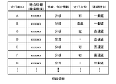
- FIG. 2 is a diagram showing a configuration example of route information sent from the autonomous driving ECU 2 to the map ECU 4, and shows data when traveling on the route shown in FIG.
- the route information includes a traveling order ID indicating the traveling order of points on the map, position information (latitude, longitude) of the point, information on whether the point is a branch or a merge, a traveling direction at the point (branch), and Includes the road type of the section from that point to the next point.
- a general road is driven to a point with a driving order ID of C, and a highway is driven from a point C to a point according to the driving order ID.
- the data of the highway from the point C to the point D is not maintained and does not pass through the entrance road at the point D, so the high speeds shown in the HD map data 5 after the point D
- the map ECU 4 cannot recognize that the vehicle is traveling on the road listed in the HD map data 5, and does not acquire a map for automatic driving or driving assistance from the HD map data 5. It will not be possible to provide automated driving or driving assistance. For this reason, in this embodiment, it is determined whether or not the vehicle is traveling on the posted road even at a place other than the entrance road, and the opportunity to provide automatic driving or driving assistance is not missed.
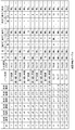
- FIG. 4 is a diagram showing a configuration example of the HD map data 5, and shows the data of the road shown in FIG.
- HD map data 5 is high-precision map data including information for each lane of a road, and is represented by a set of links defined for each lane ID. That is, the HD map data 5 includes lane ID, start latitude, start longitude, start altitude, end latitude, end longitude, end altitude, lane type, entrance road flag, right lane ID, left lane ID, number of rear lanes, rear lane. The ID, the number of front lanes, and the front lane ID are included.
- the starting point latitude, the starting point longitude, and the starting point altitude are the starting point position of the link, and the ending point latitude, the ending point longitude, and the ending point altitude are the ending point position of the link.
- the lane type indicates the type of link including the link, and is, for example, a driving lane, an overtaking lane, a ramp, or the like.
- the entrance road flag is a flag indicating whether or not the link is an entrance road, and the entrance road is, for example, an entrance road into which a general road is connected to an expressway. In particular, in a place where an expressway and an ordinary road are running side by side, the entrance road flag is used to determine the road that is running by passing through the entrance road.
- the map ECU 4 acquires map data from the HD map data 5 upon the passage of the entrance road.
- the right lane ID and the left lane ID are right and left lane IDs on a road where a plurality of lanes are lined up, respectively.
- the number of rear lanes and the rear lane ID are the number of links and the lane ID on the front side in the traveling direction of the link.
- the number of front lanes and the front lane ID are the number and lane ID of the next link on the traveling direction side of the link.
- the HD map data does not need to include all of this information as long as it can construct the road shape information and the information necessary for creating routes such as entrances, branches, and merging. For example, when there is no entrance road flag and the number of rear lanes is 0, the entrance road flag may be set to TRUE, and may be created from other information.
- FIG. 6 is a flowchart of the process executed by the map ECU 4.
- the map ECU 4 executes a matching process with the roads included in the HD map data 5 (100). If the matching of the route of the route information and the posted road is successful, it is possible to specify the lane that can be selected when traveling according to the route information.
- the map ECU 4 determines whether the posted road is an entrance road (110). Details of the entrance road determination processing will be described later with reference to FIG. 7.
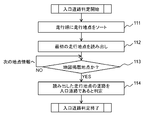
- FIG. 7 is a flowchart of the entrance road determination process.
- the map ECU 4 sorts the route information in the order of travel points according to the travel order ID (111).
- the map ECU 4 reads the first traveling point from the HD map data 5 (112) and determines whether the traveling point is a point on the posted road included in the HD map data 5 (113). If the point is not the publication point, the next traveling point information is read and the determination in step 113 is repeated.
- the point is a posting point, it is determined in the route information that it is the posting point first included in the HD map data 5, so it is determined to be an entrance road (114).
- the determined road may be set as the entrance road.
- the time point of entering the posting road included in the HD map data 5 is the entrance road, it is determined that the road is not traveling even on the roads that are not set as the entrance road in the HD map data 5. it can. For this reason, even if the entrance road information of the HD map data 5 has not been set, the availability of the HD map data 5 will not be set due to the new establishment of smart interchanges, service areas, parking areas, etc. and the addition of road connections by new junctions. It is possible to make a decision and increase opportunities to provide automated driving and driving support.
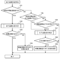
- FIG. 8 is a flowchart of a traveling road determination process executed by the map ECU 4.
- the traveling road determination process is executed at a predetermined timing (for example, a predetermined time interval).
- the map ECU 4 determines whether the current state is traveling on the posted road (131). As a result, if the current state is traveling on the posted road, the traveling road position determination processing is executed (132). In the travel route position determination process, the current position information of the vehicle is compared with the HD map data 5 to determine whether the vehicle 1 is traveling on the posted road. If the vehicle is not traveling on the posted road, the state is changed to traveling outside the posted road (134), and the traveling road determination process is ended. On the other hand, if the vehicle is traveling on the posted road, the traveling road determination process ends.
- the map ECU 4 determines whether there is an entrance road near the vehicle position (135). When there is no entrance road near the own vehicle position (NO in step 135), the map ECU 4 confirms whether or not there is a determination request from the automatic driving ECU 2 whether the vehicle is traveling on the posted road included in the HD map data 5 (136). ..
- the autonomous driving ECU 2 uses the position information output from the GNSS receiver 6 to monitor whether the vehicle is traveling in an area where the HD map data 5 is maintained.
- the automatic driving ECU 2 determines to the map ECU 4 whether the vehicle is traveling in the area where the HD map data 5 is prepared. And request the provision of high-precision map data. For example, is the autonomous driving ECU 2 traveling on a road in an area where the HD map data 5 is prepared based on the result of comparison between the position of the vehicle 1 and the HD map data 5 or the map data used by the navigation system 3. May be determined. It should be noted that the navigation system 3 may monitor whether or not the vehicle is traveling in an area where the HD map data 5 is maintained, and request the map ECU 4 to make a determination, instead of the autonomous driving ECU 2.
- map ECU 4 may determine whether or not the vehicle is traveling on the posted road when the route information is received from the autonomous driving ECU 2 or the navigation system 3.
- the map ECU 4 may determine whether or not the vehicle is running on the posted road when passing through a road having a predetermined characteristic (for example, a characteristic of a slope or a curve peculiar to the entrance road). Further, the automatic driving ECU 2 or the navigation system 3 and the map ECU 4 may request the posted road traveling determination. In this case, the map ECU 4 determines whether or not the vehicle is traveling on the posted road by using the posted road traveling determination request from the automatic driving ECU 2 or the navigation system 3 as a trigger.
- a predetermined characteristic for example, a characteristic of a slope or a curve peculiar to the entrance road.
- the map ECU 4 may determine whether or not the vehicle is traveling on the posted road when passing the merge point included in the route information. Further, the map ECU 4 may determine whether or not the vehicle is traveling on the posted road at the starting point of the traveling lane determined using the HD map data 5. By determining whether the vehicle is running on the posted road at a predetermined point (merging point, starting point of the driving lane, etc.), it is possible to determine whether the vehicle is running on the posted road without using the external information (such as peripheral images) acquired by the sensor 7. Since the determination is made, it is possible to determine whether or not the vehicle is traveling on the posted road in a short time after entering the posted road. Further, since the image processing with a large amount of calculation is not executed, the processing load can be reduced.
- step 135 If there is an entrance road near the position of the own vehicle (YES in step 135) or there is a posted road travel judgment request (YES in step 136), the process proceeds to step 137 to execute entrance road travel judgment processing. On the other hand, if there is no entrance road near the own vehicle position (NO in step 135) and there is no posted road traveling determination request (NO in step 136), the traveling road determination processing ends.
- the entrance road determination processing in step 137 it is determined whether the vehicle is traveling on the entrance road depending on whether the characteristics of the slope or curve of the entrance road and the characteristics of the traveling locus of the vehicle match. It should be noted that it may be determined whether or not the vehicle is traveling on the entrance road by comparing the characteristics of the entrance road, which are stored in advance, with the characteristics of slopes and curves common to the entrance road and the traveling locus.
- the traveling road determination processing ends.
- the determination result by the map ECU 4 is output to the automatic driving ECU 2. That is, when the map ECU 4 determines that the vehicle is traveling on the posted road, it extracts the high-precision map data of the area required for traveling from the HD map data 5 and transmits it to the automatic driving ECU 2.
- the high-precision map data transmitted to the automatic driving ECU 2 includes lane information, and the automatic driving ECU 2 uses the acquired high-precision map data to determine the lane on which the vehicle travels to perform automatic driving or driving assistance. provide.
- the automatic driving ECU 2 cannot acquire the data for determining the lane on which the vehicle travels, and therefore controls the automatic driving to be prohibited.
- the map ECU 4 does not operate on the entrance road that can enter the posted road included in the HD map data 5 (map data).
- the posted road is triggered by the reception of predetermined information (for example, a request to determine whether the road is running on the posted road, route information) from the autonomous driving ECU 2 (travel control unit) or the navigation system 3 (route generation unit). Since it is determined whether or not the vehicle is traveling, even if the entrance road is not defined in the HD map data 5, it is possible to determine whether or not the vehicle is traveling on the posted road by referring to other information. Therefore, even from the point where the entrance road data is not prepared, the information of the traveling lane using the HD map data 5 can be generated, and the automatic driving and the driving support can be started.
- the map ECU 4 receives information on the outside world (such as peripheral images) acquired by the sensor 7 and the HD map data 5 at a position other than the entrance road, triggered by reception of predetermined information from the automatic driving ECU 2 or the navigation system 3. It is possible to determine whether the vehicle is traveling on the posted road by using the degree of coincidence, so that it is possible to determine whether the vehicle is traveling on the posted road even if the navigation system 3 does not generate the route. But it can provide automated driving and driving support.
- the outside world such as peripheral images
- the map ECU 4 uses the degree of coincidence between the map used by the navigation system 3 and the HD map data 5 at the position other than the entrance road, triggered by the reception of predetermined information from the automatic driving ECU 2 or the navigation system 3. Since it is determined whether the vehicle is traveling on the posted road, it is possible to determine whether the vehicle is traveling on the posted road even if the entrance road is not defined in the HD map data 5 on the route to the destination. Can provide assistance.
- the autonomous driving ECU 2 requests the map ECU 4 to determine whether the vehicle is running on the posted road based on the result of comparison between the position of the vehicle and the map data, the autonomous driving ECU 2 takes the initiative to run on the posted road. It is possible to determine whether or not it is done, it is easy to implement, and the amount of calculation can be suppressed.
- the map ECU 4 determines whether or not the vehicle is traveling on the posted road on the occasion of receiving the route information from the automatic driving ECU 2 or the navigation system 3, and thus gives an opportunity to determine whether or not the vehicle is already traveling on the posted road. It is possible to provide automatic driving and driving support at an earlier timing. For example, if the driver does not erroneously determine that the vehicle is the entrance road when the vehicle passes the entrance road, it is possible to eliminate the inconvenience that automatic driving or driving assistance cannot be started until the vehicle next passes the entrance road.
- the map ECU 4 determines whether or not the vehicle is running on the posted road when it passes the road having a predetermined characteristic after receiving the route information from the automatic driving ECU 2 or the navigation system 3, so that the passage of the specific point is performed. It is possible to judge whether or not the vehicle is traveling on the posted road, and provide automatic driving and driving support at an earlier timing.
- the map ECU 4 determines whether the vehicle is traveling on the posted road when the vehicle passes the merge point included in the route information, the map ECU 4 travels on the posted road triggered by the passage of a point that is likely to have entered the posted road. It is possible to determine whether the road is included in the HD map data 5, and to extract roads that may be included in the HD map data 5, and to provide automatic driving and driving support at an earlier timing.
- the map ECU 4 determines whether or not the vehicle is traveling on the posted road at the starting point of the traveling lane determined by the automatic driving ECU 2, so whether the vehicle is traveling on the posted road at the closest position where the traveling lane information can be created. It is possible to provide automatic driving and driving support at an earlier timing by judging.
- the present invention is not limited to the above-described embodiments, but includes various modifications and equivalent configurations within the scope of the appended claims.
- the above-described embodiments have been described in detail in order to explain the present invention in an easy-to-understand manner, and the present invention is not necessarily limited to those having all the configurations described.
- part of the configuration of one embodiment may be replaced with the configuration of another embodiment.
- the configuration of another embodiment may be added to the configuration of one embodiment.
- a part of the configuration of each embodiment may be added, deleted, or replaced with another configuration.
- each of the above-mentioned configurations, functions, processing units, processing means, etc. may be realized by hardware, for example, by designing a part or all of them with an integrated circuit, and the processor realizes each function. It may be realized by software by interpreting and executing the program.
- Information such as programs, tables, and files that realize each function can be stored in a memory, a hard disk, a storage device such as SSD (Solid State Drive), or a recording medium such as an IC card, SD card, or DVD.
- SSD Solid State Drive
- control lines and information lines are shown to be necessary for explanation, and not all the control lines and information lines necessary for implementation are shown. In reality, it can be considered that almost all configurations are connected to each other.
Landscapes
- Engineering & Computer Science (AREA)
- Physics & Mathematics (AREA)
- General Physics & Mathematics (AREA)
- Remote Sensing (AREA)
- Radar, Positioning & Navigation (AREA)
- Automation & Control Theory (AREA)
- Theoretical Computer Science (AREA)
- Transportation (AREA)
- Mechanical Engineering (AREA)
- Human Computer Interaction (AREA)
- Mathematical Physics (AREA)
- Business, Economics & Management (AREA)
- Educational Administration (AREA)
- Educational Technology (AREA)
- Navigation (AREA)
- Traffic Control Systems (AREA)
- Control Of Driving Devices And Active Controlling Of Vehicle (AREA)
- Instructional Devices (AREA)
Abstract
本発明は、高精度地図への切替ポイントを的確に判定する。車両が走行する経路情報を生成する経路生成部と、車両の位置を測定する位置測定部と、経路情報に従った車両の走行を制御する走行制御部と、車両の走行を制御するために使用される地図データを保持し、地図データを走行制御部に出力する地図データ管理部とを備える車両制御システムであって、前記地図データ管理部は、地図データに含まれる道路へ進入可能な入口道路の位置情報を用いて地図データに含まれる道路を走行しているかを判定し、入口道路ではない位置において、走行制御部又は経路生成部からの所定の情報の受信を契機として、地図データに含まれる道路を走行しているかを判定し、走行制御部は、地図データに含まれる道路を走行していないと地図データ管理部が判定した場合、走行制御部による車両の走行の制御を禁止する。
Description
本発明は、車両制御システムに関する。
運転者の操作なしで車両を走行する自動運転機能や、運転者の操作を支援して車両を走行する運転支援機能には高精度の詳細な地図が使用されている。現状では、このような高精度地図は車両が走行可能な日本全国の道路において整備されているわけではなく、高速道路、自動車専用道などの特定の道路で整備されているに過ぎない。このため、走行経路において、高精度地図が使用可能かを判定し、自動運転機能や運転支援機能を提供することが求められている。
本技術分野の背景技術として、以下の先行技術がある。特許文献1(特開2018-30500号公報)には、車両が進入した自動車専用道路の出入口の先に複数の分岐路入口が接続している場合に、所定のタイミングに至るまでに操舵が行われないときには、車両を基準とした第1許容範囲内の分岐路入口の一つに向かって車両の自動運転を行い、所定のタイミングに至るまでに操舵が行われたときには、その操舵が終了したときの車両を基準とした第2許容範囲内の分岐路入口の一つに向かって車両の自動運転を行い、第1許容範囲内又は第2許容範囲内に分岐路入口が存在しないときには、運転者に通知を行う、自動運転システムが記載されている(要約参照)。
また、特許文献2(特開2018-96743号公報)には、道路のデータを有する自動運転用地図データと、道路のデータであって自動運転用地図データと内容が一部重複するデータを有するナビゲーション用地図データと、外部測位システムにより測位された自車の位置情報とに基づいて、自車の走行している道路を特定する道路特定装置が記載されている(請求項1参照)。
高精度地図は車両が走行可能な日本全国の道路において整備されていないので、高精度地図へ進入可能な地点(入口道路)を定義して、入口道路の通過によって、高精度地図が利用可能かを判定して、併走道路走行中における誤判定を抑制し、演算量を低減している。
しかし、高精度地図は、実際に道路を走行して測定されたデータに基づいて作成されるので、ナビゲーションシステムで使用される地図データより更新タイミングが遅くなる。このため、ナビゲーションシステムで生成された経路情報で走行すべき道路の情報と高精度地図とが整合しないことがある。特に、一般道から高速道路へ乗り入れる入口(インターチェンジ、ランプなど)が新設されると、高精度地図が利用可能な道路に入ったと判定されず、自動運転や運転支援の提供機会を逃すことがある。
また、高精度地図の整備が進んでも、ナビゲーションシステムで使用される地図データより遅く更新され、抜けなく地図が整備されることは保証されるものではない。
このため、高精度地図への切替ポイントの的確な判定が望まれている。
本願において開示される発明の代表的な一例を示せば以下の通りである。すなわち、車両の走行を制御する車両制御システムであって、ユーザから入力された情報に基づいて前記車両が走行する経路情報を生成する経路生成部と、前記車両の位置を測定する位置測定部と、前記生成された経路情報に従った車両の走行を制御する走行制御部と、前記車両の走行を制御するために使用される地図データを保持し、前記生成された経路情報及び前記車両の位置に基づいて、前記地図データを前記走行制御部に出力する地図データ管理部とを備え、前記地図データ管理部は、前記地図データに含まれる道路へ進入可能な入口道路の位置情報を用いて前記地図データに含まれる道路を走行しているかを判定し、前記入口道路ではない位置において、前記走行制御部又は前記経路生成部からの所定の情報の受信を契機として、前記地図データに含まれる道路を走行しているかを判定し、前記走行制御部は、前記地図データに含まれる道路を走行していないと前記地図データ管理部が判定した場合、前記走行制御部による車両の走行の制御を禁止することを特徴とする。
本発明の一態様によれば、高精度地図への切替ポイントを的確に判定でき、自動運転や運転支援の提供機会を増加できる。前述した以外の課題、構成及び効果は、以下の実施例の説明によって明らかにされる。
図1は、本発明の実施例の車両制御システムの構成を示す図である。
本実施例の車両制御システムは、自動運転ECU2、ナビゲーションシステム3、マップECU4、HD地図データ5、GNSS受信機6及びセンサ7を有し、車両1に搭載される。
自動運転ECU2は、ナビゲーションシステム3が生成した経路情報を用いて車両1が自動運転するための詳細な経路情報を生成し、生成された経路情報に従って、車両1に搭載されたセンサ7(カメラ、レーダ、LIDERなど)が取得した外界の情報を用いてステアリング、アクセル及びブレーキを動作して、車両1の走行を制御する。本実施例の自動運転ECU2は、高速道路や自動車専用道などの特定の道路において、運転者の操作なしで車両を走行する自動運転機能、及び運転者の操作を支援して車両を走行する運転支援機能の少なくとも一方を提供する。
ナビゲーションシステム3は、操作者が目的地や経路を入力すると、道路地図を参照して走行経路を演算して、生成した経路情報を自動運転ECU2に送る。ナビゲーションシステム3が使用する道路地図は、ナビゲーションシステム3に内蔵される記憶装置に格納されていても、ネットワークを介して接続される地図サーバ(図示省略)から取得してもよい。ナビゲーションシステム3が生成した経路情報は、自動運転ECU2を経由して、マップECU4に送られる。なお、ナビゲーションシステム3は、生成した経路情報をマップECU4に直接送ってもよい。ナビゲーションシステム3からマップECU4に送られる経路情報の構成例は、図2を用いて後述する。
マップECU4は、HD地図データ5に格納された高精度の地図データを管理する。マップECU4には、GNSS受信機6が測定した自車の位置情報やセンサ7が取得した外界の情報が入力され、HD地図データ5に含まれる掲載道路上にいるかを判定し、HD地図データ5から取得するデータを選択する。HD地図データ5は、自動運転のための、道路のレーンごとの情報を含む高精度の地図データである。このため、HD地図データ5は、自動運転や運転支援を提供可能な道路の高精度の地図データを含み、それ以外の道路(例えば、一般道)のデータを含まない。HD地図データ5の構成例は、図4を用いて後述する。
自動運転ECU2及びマップECU4は、車両を制御するコンピュータであって、記憶媒体(例えば、不揮発性メモリ)に記憶されたプログラムを実行することによって、各ECUの機能を実現する。各ECU2、4は、車両のCANなどの通信手段に接続され、GNSS受信機6やセンサ7からの情報が入力される。自動運転ECU2には、車両の車速、舵角、シフト位置などの車両情報が入力され、ステアリング、アクセル、ブレーキなどのアクチュエータを制御する。
図2は、自動運転ECU2からマップECU4に送られる経路情報の構成例を示す図であり、図3に示す経路を走行する場合のデータを示す。
経路情報は、地図上の地点の走行順を表す走行順ID、当該地点の位置情報(緯度、経度)、当該地点が分岐又は合流であるかの情報、当該地点(分岐)における進行方向、及び当該地点から次の地点までの区間の道路種別を含む。
図2に示す経路情報では、図3に示すように、走行順IDがCの地点まで一般道を走行し、走行順IDに従ってC地点からF地点まで高速道路を走行する。しかし、HD地図データ5において、C地点からD地点までの高速道路のデータは整備されておらず、D地点で入口道路を通過しないので、地点D以後にHD地図データ5に掲載されている高速道路を走行しても、マップECU4はHD地図データ5に掲載されている道路を走行していることを認識できず、自動運転や運転支援のための地図をHD地図データ5から取得せず、自動運転や運転支援を提供できないことになる。このため、本実施例では、入口道路以外の場所でも掲載道路を走行中であるかを判定して、自動運転や運転支援の提供機会を逃さないようにしている。
図4は、HD地図データ5の構成例を示す図であり、図5に示す道路のデータを示す。
HD地図データ5は、道路のレーンごとの情報を含む高精度の地図データであり、レーンIDごとに定義されるリンクの集合で表される。すなわち、HD地図データ5は、レーンID、始点緯度、始点経度、始点高度、終点緯度、終点経度、終点高度、レーン種別、入口道路フラグ、右レーンID、左レーンID、後方レーン数、後方レーンID、前方レーン数、及び前方レーンIDを含む。
始点緯度、始点経度、及び始点高度は、当該リンクの始点位置であり、終点緯度、終点経度、終点高度は、当該リンクの終点位置である。レーン種別は、当該リンクが含まれるリンクの種別を示し、例えば、走行車線、追い越し車線、ランプ等である。入口道路フラグは、当該リンクが入口道路であるかを示すフラグであり、入口道路は、例えば一般道から高速道路へ乗り入れる入口の道路である。特に、高速道路と一般道路とが並走している場所において、入口道路の通過によって走行中の道路を判別するために、入口道路フラグが使用される。入口道路では、手前側の経路がないため、後方レーン数が0であり、後方レーンIDが無しとなっている。マップECU4は、入口道路の通過を契機として、HD地図データ5から地図データを取得する。右レーンID及び左レーンIDは、複数レーンが並んでいる道路における、それぞれ、右側及び左側のレーンIDである。後方レーン数及び後方レーンIDは、当該リンクの進行方向手前側のリンクの数及びレーンIDである。前方レーン数及び前方レーンIDは、当該リンクの進行方向側の次のリンクの数及びレーンIDである。
ここで、HD地図データはこれら全ての情報を含んでいる必要はなく道路の形状情報及び入口、分岐・合流等の経路作成に必要な情報を構築出来ればよい。例えば、入口道路フラグが無く後方レーン数が0の場合に入口道路フラグがTRUEとする等、他の情報から作成すればよい。
図6は、マップECU4が実行する処理のフローチャートである。
まず、マップECU4は、ナビゲーションシステム3が生成した経路情報を受信すると、HD地図データ5に含まれる掲載道路とのマッチング処理を実行する(100)。経路情報の経路と掲載道路とのマッチングに成功すると、経路情報に従った走行時に選択可能なレーンを特定できる。
マッチング処理によって、経路情報に従って掲載道路を走行可能であると判定されると、マップECU4は、当該掲載道路が入り口道路であるかを判定する(110)。入口道路判定処理の詳細は図7を参照して後述する。
図7は、入口道路判定処理のフローチャートである。
まず、マップECU4は、経路情報を走行順IDに従って走行地点順にソートする(111)。
次に、マップECU4は、最初の走行地点をHD地図データ5から読み出して(112)、当該走行地点がHD地図データ5に含まれる掲載道路上の地点であるかを判定する(113)。当該地点が掲載地点でなければ、次の走行地点情報を読み出して、ステップ113の判定を繰り返す。
一方、当該地点が掲載地点であれば、この経路情報において、最初にHD地図データ5に含まれる掲載地点であると判定されたので、入口道路であると判定する(114)。なお、判定された道路を入口道路であると設定してもよい。
このように、HD地図データ5に含まれる掲載道路に入る時点を入口道路であると判定するので、HD地図データ5に入口道路として設定されていない道路でも、掲載道路を走行中であると判定できる。このため、スマートインターチェンジ、サービスエリア、パーキングエリアなどの新設や、新規ジャンクションによる道路の接続の追加によって、HD地図データ5の入口道路情報が未設定であっても、HD地図データ5の利用可否を判定でき、自動運転や運転支援の提供機会を増加できる。
図8は、マップECU4が実行する走行道路判定処理のフローチャートである。走行道路判定処理は、所定のタイミング(例えば、所定時間間隔)で実行される。
マップECU4は、走行道路判定処理を開始すると、現在の状態が掲載道路走行中であるかを判定する(131)。その結果、現在の状態が掲載道路走行中であれば、走行道路位置判定処理を実行する(132)。走行経路位置判定処理では、現在の車両の位置情報とHD地図データ5とを照合して、車両1が掲載道路を走行中であるかを判定する。そして、掲載道路を走行中でなければ、状態を掲載道路外走行中に変更し(134)、走行道路判定処理を終了する。一方、掲載道路を走行中であれば、走行道路判定処理を終了する。
一方、現在の状態が掲載道路走行中でなければ、マップECU4は、自車位置近傍に入口道路が存在するかを判定する(135)。自車位置近傍に入口道路が無い場合(ステップ135でNO)、マップECU4は、自動運転ECU2からHD地図データ5に含まれる掲載道路を走行しているかの判定要求の有無を確認する(136)。自動運転ECU2は、GNSS受信機6から出力される位置情報を用いて、HD地図データ5が整備されている区域を走行しているかを監視している。そして、HD地図データ5が整備されている区域を走行している可能性がある場合に、自動運転ECU2は、マップECU4に、HD地図データ5が整備されている区域を走行しているかの判定を要求し、高精度地図データの提供を要求する。例えば、自動運転ECU2は、車両1の位置とHD地図データ5又はナビゲーションシステム3が使用する地図データとの比較結果に基づいて、HD地図データ5が整備されている区域の道路を走行しているかを判定してもよい。なお、自動運転ECU2ではなく、ナビゲーションシステム3が、HD地図データ5が整備されている区域を走行しているかを監視し、マップECU4に判定を要求してもよい。
さらに、マップECU4は、自動運転ECU2又はナビゲーションシステム3から経路情報を受信した場合に掲載道路を走行しているかを判定してもよい。
さらに、マップECU4は、所定の特徴(例えば、入口道路に特有の傾斜や曲線の特徴)を有する道路を通過した場合に掲載道路を走行しているかを判定してもよい。また、自動運転ECU2又はナビゲーションシステム3が、マップECU4は、掲載道路走行判定を要求してもよい。この場合、マップECU4は、自動運転ECU2又はナビゲーションシステム3からの掲載道路走行判定要求をトリガに掲載道路を走行しているかを判定する。
また、マップECU4は、経路情報に含まれる合流地点を通過した場合に掲載道路を走行しているかを判定してもよい。また、マップECU4は、HD地図データ5を用いて決定された走行レーンの起点において、掲載道路を走行しているかを判定してもよい。所定の地点(合流地点、走行レーンの起点など)において掲載道路を走行中かを判定することによって、センサ7が取得した外界の情報(周辺画像など)を用いないで掲載道路を走行中かを判定するので、掲載道路への進入後に短時間で掲載道路を走行中かを判定できる。また、演算量が多い画像処理を実行しないので、処理負荷を軽減できる。
そして、自車位置近傍に入口道路が存在する(ステップ135でYES)又は掲載道路走行判定要求がある(ステップ136でYES)場合、ステップ137に進み、入口道路走行判定処理を実行する。一方、自車位置近傍に入口道路が存在しない(ステップ135でNO)かつ掲載道路走行判定要求がない(ステップ136でNO)場合、走行道路判定処理を終了する。
ステップ137の入口道路判定処理では、入口道路の傾斜や曲線の特徴と自車の走行軌跡の特徴とが一致するかによって、入口道路を走行中かを判定する。なお、個々の入口道路の特徴ではなく、予め格納された入口道路に共通する傾斜や曲線の特徴と走行軌跡とを比較して、入口道路を走行中かを判定してもよい。
また、ステップ137でセンサ7が取得した外界の情報(周辺画像など)とHD地図データ5との一致度を用いて、掲載道路を走行しているかを判定してもよい。すなわち、外界の情報とHD地図データ5との一致度が所定の閾値より高ければ、掲載道路を走行していると判定するとよい。この場合、ナビゲーションシステム3が経路を生成していなくても掲載道路上を走行しているかを判定できる。このため、非常事態に対応でき、緊急事態でも危険を回避できる。例えば、経路が設定されていない道路でも自動運転可能状態となり、運転者が運転不能状態になった場合に自動運転に切り替えることができ、車両を適切に制御して、安全な場所まで移動させることができる。
また、ナビゲーションシステム3が使用する地図とHD地図データ5との一致度を用いて、掲載道路を走行しているかを判定してもよい。すなわち、ナビゲーションシステム3が使用する地図とHD地図データ5との一致度が所定の閾値より高ければ、掲載道路を走行していると判定するとよい。この場合、目的地への経路上でHD地図データ5に入口道路が定義されていなくても、掲載道路を走行しているかを判定でき、自動運転や運転支援を提供できる。
そして、入り口道路を走行中であると判定されると(138でYes)、掲載道路走行中に状態を変更する(139)。一方、入り口道路を走行中でないと判定されると(138でNo)、走行道路判定処理を終了する。
マップECU4による判定結果は、自動運転ECU2に出力される。すなわち、マップECU4は、掲載道路を走行中であると判定すると、HD地図データ5から走行に必要な領域の高精度地図データを取り出し、自動運転ECU2に送信する。自動運転ECU2に送信される高精度地図データはレーンの情報を含んでおり、自動運転ECU2は、取得した高精度地図データを用いて、車両が走行するレーンを決定し、自動運転又は運転支援を提供する。
一方、マップECU4が、掲載道路を走行中でないと判定すると、自動運転ECU2は、車両が走行するレーンを決定するためのデータを取得できないことから、自動運転を禁止するように制御する。
以上に説明したように、本発明の実施例によると、マップECU4(地図データ管理部、地図データ管理装置)は、HD地図データ5(地図データ)に含まれる掲載道路へ進入可能な入口道路ではない位置において、自動運転ECU2(走行制御部)又はナビゲーションシステム3(経路生成部)からの所定の情報(例えば、掲載道路走行中かの判定要求、経路情報)の受信を契機として、掲載道路を走行しているかを判定するので、HD地図データ5に入口道路が定義されていなくても、他の情報を参照して掲載道路を走行しているかを判定できる。このため、入口道路データが整備されていない地点からも、HD地図データ5を使用した走行レーンの情報を生成でき、自動運転や運転支援を開始できる。
また、マップECU4は、入口道路ではない位置において、自動運転ECU2又はナビゲーションシステム3からの所定の情報の受信を契機として、センサ7が取得した外界の情報(周辺画像など)とHD地図データ5との一致度を用いて、掲載道路を走行しているかを判定するので、ナビゲーションシステム3が経路を生成していなくても掲載道路上を走行しているかを判定でき、経路が設定されていない道路でも自動運転や運転支援を提供できる。
また、マップECU4は、入口道路ではない位置において、自動運転ECU2又はナビゲーションシステム3からの所定の情報の受信を契機として、ナビゲーションシステム3が使用する地図とHD地図データ5との一致度を用いて、掲載道路を走行しているかを判定するので、目的地への経路上でHD地図データ5に入口道路が定義されていなくても、掲載道路を走行しているかを判定でき、自動運転や運転支援を提供できる。
また、自動運転ECU2は、前記車両の位置と前記地図データとの比較結果に基づいて、掲載道路を走行しているかの判定をマップECU4に要求するので、自動運転ECU2が主導で掲載道路を走行しているかを判定でき、実装が容易であり、演算量を抑制できる。
また、マップECU4は、自動運転ECU2又はナビゲーションシステム3からの経路情報の受信を契機に掲載道路を走行しているかを判定するので、既に掲載道路走行中でも掲載道路走行中かの判定の契機を与えることができ、より早いタイミングで自動運転や運転支援を提供できる。例えば、入口道路を通過した際に入口道路であることを誤って判定しなかった場合、次に入口道路を通過するまで自動運転や運転支援を起動できない不都合を解消できる。
また、マップECU4は、自動運転ECU2又はナビゲーションシステム3から経路情報を受信した後、所定の特徴を有する道路を通過した場合に、掲載道路を走行しているかを判定するので、特定の地点の通過を契機に掲載道路を走行しているかを判定して、より早いタイミングで自動運転や運転支援を提供できる。
また、マップECU4は、経路情報に含まれる合流地点を通過した場合、掲載道路を走行しているかを判定するので、掲載道路に進入した可能性が高い地点の通過を契機に掲載道路を走行しているかを判定して、HD地図データ5に含まれる可能性がある道路を抽出でき、より早いタイミングで自動運転や運転支援を提供できる。
また、マップECU4は、自動運転ECU2で決定された走行レーンの起点において、掲載道路を走行しているかを判定するので、走行レーン情報が作成できた最も手前の位置で掲載道路を走行しているかを判定して、より早いタイミングで自動運転や運転支援を提供できる。
なお、本発明は前述した実施例に限定されるものではなく、添付した特許請求の範囲の趣旨内における様々な変形例及び同等の構成が含まれる。例えば、前述した実施例は本発明を分かりやすく説明するために詳細に説明したものであり、必ずしも説明した全ての構成を備えるものに本発明は限定されない。また、ある実施例の構成の一部を他の実施例の構成に置き換えてもよい。また、ある実施例の構成に他の実施例の構成を加えてもよい。また、各実施例の構成の一部について、他の構成の追加・削除・置換をしてもよい。
また、前述した各構成、機能、処理部、処理手段等は、それらの一部又は全部を、例えば集積回路で設計する等により、ハードウェアで実現してもよく、プロセッサがそれぞれの機能を実現するプログラムを解釈し実行することにより、ソフトウェアで実現してもよい。
各機能を実現するプログラム、テーブル、ファイル等の情報は、メモリ、ハードディスク、SSD(Solid State Drive)等の記憶装置、又は、ICカード、SDカード、DVD等の記録媒体に格納することができる。
また、制御線や情報線は説明上必要と考えられるものを示しており、実装上必要な全ての制御線や情報線を示しているとは限らない。実際には、ほとんど全ての構成が相互に接続されていると考えてよい。
1 車両、2 自動運転ECU、3 ナビゲーションシステム、4 マップECU、5 HD地図データ、6 GNSS受信機、7 センサ
Claims (15)
- 車両の走行を制御する車両制御システムであって、
ユーザから入力された情報に基づいて前記車両が走行する経路情報を生成する経路生成部と、
前記車両の位置を測定する位置測定部と、
前記生成された経路情報に従った車両の走行を制御する走行制御部と、
前記車両の走行を制御するために使用される地図データを保持し、前記生成された経路情報及び前記車両の位置に基づいて、前記地図データを前記走行制御部に出力する地図データ管理部とを備え、
前記地図データ管理部は、
前記地図データに含まれる道路へ進入可能な入口道路の位置情報を用いて前記地図データに含まれる道路を走行しているかを判定し、
前記入口道路ではない位置において、前記走行制御部又は前記経路生成部からの所定の情報の受信を契機として、前記地図データに含まれる道路を走行しているかを判定し、
前記走行制御部は、前記地図データに含まれる道路を走行していないと前記地図データ管理部が判定した場合、前記走行制御部による車両の走行の制御を禁止することを特徴とする車両制御システム。 - 請求項1に記載の車両制御システムであって、
前記地図データ管理部は、前記入口道路ではない位置において、前記走行制御部又は前記経路生成部からの所定の情報の受信を契機として、センサによって取得した周辺画像を含む外界の情報と前記地図データとの一致度を用いて、前記地図データに含まれる道路を走行しているかを判定することを特徴とする車両制御システム。 - 請求項1に記載の車両制御システムであって、
前記地図データ管理部は、前記入口道路ではない位置において、前記走行制御部又は前記経路生成部からの所定の情報の受信を契機として、前記経路情報の生成に用いた地図と前記地図データとの一致度を用いて、前記地図データに含まれる道路を走行しているかを判定することを特徴とする車両制御システム。 - 請求項1に記載の車両制御システムであって、
前記走行制御部は、前記車両の位置と前記地図データとの比較結果に基づいて、前記地図データに含まれる道路を走行しているかの判定を前記地図データ管理部に要求することを特徴とする車両制御システム。 - 請求項1に記載の車両制御システムであって、
前記地図データ管理部は、前記走行制御部又は前記経路生成部からの経路情報の受信を契機に、前記地図データに含まれる道路を走行しているかを判定することを特徴とする車両制御システム。 - 請求項1に記載の車両制御システムであって、
前記地図データ管理部は、前記走行制御部又は前記経路生成部から経路情報を受信した後、所定の特徴を有する道路を通過した場合に、前記地図データに含まれる道路を走行しているかを判定することを特徴とする車両制御システム。 - 請求項6に記載の車両制御システムであって、
前記地図データ管理部は、前記走行制御部又は前記経路生成部から経路情報を受信した後、前記経路情報に含まれる合流地点を通過した場合に、前記地図データに含まれる道路を走行しているかを判定することを特徴とする車両制御システム。 - 請求項6に記載の車両制御システムであって、
前記地図データ管理部は、前記走行制御部に出力された地図データを用いて決定された走行レーンの起点において、前記地図データに含まれる道路を走行しているかを判定することを特徴とする車両制御システム。 - 車両の走行を制御するために使用される地図データを管理する地図データ管理装置であって、
経路生成部が生成した経路情報に従った車両の走行を制御する走行制御部からの所定の情報の受信を契機として、地図データを出力し、
前記地図データに含まれる道路へ進入可能な入口道路の位置情報を用いて前記地図データに含まれる道路を走行しているかを判定し、
前記入口道路ではない位置において、前記走行制御部又は前記経路生成部からの所定の情報の受信を契機として、前記地図データに含まれる道路を走行しているかを判定することを特徴とする地図データ管理装置。 - 請求項9に記載の地図データ管理装置であって、
前記入口道路ではない位置において、前記走行制御部又は前記経路生成部からの所定の情報の受信を契機として、センサによって取得した周辺画像を含む外界の情報と前記地図データとの一致度を用いて、前記地図データに含まれる道路を走行しているかを判定することを特徴とする地図データ管理装置。 - 請求項9に記載の地図データ管理装置であって、
前記入口道路ではない位置において、前記走行制御部又は前記経路生成部からの所定の情報の受信を契機として、前記経路情報の生成に用いた地図と前記地図データとの一致度を用いて、前記地図データに含まれる道路を走行しているかを判定することを特徴とする地図データ管理装置。 - 請求項9に記載の地図データ管理装置であって、
前記走行制御部又は前記経路生成部からの経路情報の受信を契機に、前記地図データに含まれる道路を走行しているかを判定することを特徴とする地図データ管理装置。 - 請求項9に記載の地図データ管理装置であって、
前記走行制御部又は前記経路生成部から経路情報を受信した後、所定の特徴を有する道路を通過した場合に、前記地図データに含まれる道路を走行しているかを判定することを特徴とする地図データ管理装置。 - 請求項13に記載の地図データ管理装置であって、
前記走行制御部又は前記経路生成部から経路情報を受信した後、前記経路情報に含まれる合流地点を通過した場合に、前記地図データに含まれる道路を走行しているかを判定することを特徴とする地図データ管理装置。 - 請求項13に記載の地図データ管理装置であって、
前記走行制御部に出力された地図データを用いて決定された走行レーンの起点において、前記地図データに含まれる道路を走行しているかを判定することを特徴とする地図データ管理装置。
Priority Applications (1)
| Application Number | Priority Date | Filing Date | Title |
|---|---|---|---|
| JP2020558365A JPWO2020110792A1 (ja) | 2018-11-29 | 2019-11-18 | 車両制御システム及び地図データ管理装置 |
Applications Claiming Priority (2)
| Application Number | Priority Date | Filing Date | Title |
|---|---|---|---|
| JP2018223831 | 2018-11-29 | ||
| JP2018-223831 | 2018-11-29 |
Publications (1)
| Publication Number | Publication Date |
|---|---|
| WO2020110792A1 true WO2020110792A1 (ja) | 2020-06-04 |
Family
ID=70852965
Family Applications (1)
| Application Number | Title | Priority Date | Filing Date |
|---|---|---|---|
| PCT/JP2019/045008 Ceased WO2020110792A1 (ja) | 2018-11-29 | 2019-11-18 | 車両制御システム及び地図データ管理装置 |
Country Status (2)
| Country | Link |
|---|---|
| JP (1) | JPWO2020110792A1 (ja) |
| WO (1) | WO2020110792A1 (ja) |
Cited By (3)
| Publication number | Priority date | Publication date | Assignee | Title |
|---|---|---|---|---|
| CN114413926A (zh) * | 2021-12-13 | 2022-04-29 | 武汉中海庭数据技术有限公司 | 基于mapbox引擎osm数据与高精度数据的地图显示方法 |
| JP2024525347A (ja) * | 2021-06-18 | 2024-07-12 | メルセデス・ベンツ グループ アクチェンゲゼルシャフト | 自動運転動作のために設計されている車両を動作させるための方法 |
| JP2025510162A (ja) * | 2022-03-25 | 2025-04-14 | メルセデス・ベンツ グループ アクチェンゲゼルシャフト | 車両の自動走行動作のためのナビゲーションルートを決定する方法 |
Citations (4)
| Publication number | Priority date | Publication date | Assignee | Title |
|---|---|---|---|---|
| WO2017051478A1 (ja) * | 2015-09-25 | 2017-03-30 | 三菱電機株式会社 | 運転支援装置および運転支援方法 |
| JP2017090299A (ja) * | 2015-11-12 | 2017-05-25 | 株式会社トヨタマップマスター | ナビゲーションシステム、経路案内ルート探索方法、経路案内ルート探索プログラム、及び記録媒体 |
| JP2017142145A (ja) * | 2016-02-10 | 2017-08-17 | 株式会社ゼンリン | 車線変更支援装置、車両制御装置およびその方法 |
| JP2017215653A (ja) * | 2016-05-30 | 2017-12-07 | 株式会社デンソー | 詳細経路作成装置、車両用自動運転システム及び詳細経路作成プログラム |
-
2019
- 2019-11-18 JP JP2020558365A patent/JPWO2020110792A1/ja active Pending
- 2019-11-18 WO PCT/JP2019/045008 patent/WO2020110792A1/ja not_active Ceased
Patent Citations (4)
| Publication number | Priority date | Publication date | Assignee | Title |
|---|---|---|---|---|
| WO2017051478A1 (ja) * | 2015-09-25 | 2017-03-30 | 三菱電機株式会社 | 運転支援装置および運転支援方法 |
| JP2017090299A (ja) * | 2015-11-12 | 2017-05-25 | 株式会社トヨタマップマスター | ナビゲーションシステム、経路案内ルート探索方法、経路案内ルート探索プログラム、及び記録媒体 |
| JP2017142145A (ja) * | 2016-02-10 | 2017-08-17 | 株式会社ゼンリン | 車線変更支援装置、車両制御装置およびその方法 |
| JP2017215653A (ja) * | 2016-05-30 | 2017-12-07 | 株式会社デンソー | 詳細経路作成装置、車両用自動運転システム及び詳細経路作成プログラム |
Cited By (8)
| Publication number | Priority date | Publication date | Assignee | Title |
|---|---|---|---|---|
| JP2024525347A (ja) * | 2021-06-18 | 2024-07-12 | メルセデス・ベンツ グループ アクチェンゲゼルシャフト | 自動運転動作のために設計されている車両を動作させるための方法 |
| JP7596565B2 (ja) | 2021-06-18 | 2024-12-09 | メルセデス・ベンツ グループ アクチェンゲゼルシャフト | 自動運転動作のために設計されている車両を動作させるための方法 |
| US12630192B2 (en) | 2021-06-18 | 2026-05-19 | Mercedes-Benz Group AG | Method for operating a vehicle equipped for an automated driving operation |
| CN114413926A (zh) * | 2021-12-13 | 2022-04-29 | 武汉中海庭数据技术有限公司 | 基于mapbox引擎osm数据与高精度数据的地图显示方法 |
| CN114413926B (zh) * | 2021-12-13 | 2023-10-13 | 武汉中海庭数据技术有限公司 | 基于mapbox引擎osm数据与高精度数据的地图显示方法 |
| JP2025510162A (ja) * | 2022-03-25 | 2025-04-14 | メルセデス・ベンツ グループ アクチェンゲゼルシャフト | 車両の自動走行動作のためのナビゲーションルートを決定する方法 |
| JP7818717B2 (ja) | 2022-03-25 | 2026-02-20 | メルセデス・ベンツ グループ アクチェンゲゼルシャフト | 車両の自動走行動作のためのナビゲーションルートを決定する方法 |
| US12703389B2 (en) | 2022-03-25 | 2026-08-11 | Mercedes-Benz Group AG | Method for determining a navigation route for an automated driving operation of a vehicle |
Also Published As
| Publication number | Publication date |
|---|---|
| JPWO2020110792A1 (ja) | 2021-10-14 |
Similar Documents
| Publication | Publication Date | Title |
|---|---|---|
| US11597387B2 (en) | Vehicle controller, vehicle, and vehicle control method | |
| US20180037223A1 (en) | Autonomous driving assistance system, autonomous driving assistance method, and computer program | |
| US11409728B2 (en) | Map information system | |
| CN110874229A (zh) | 自动驾驶汽车的地图升级方法、装置 | |
| JP6419666B2 (ja) | 自動運転装置 | |
| CN114407915B (zh) | 运行设计域odd的处理方法、装置及存储介质 | |
| JP7524806B2 (ja) | 車両制御装置、車両制御用コンピュータプログラム及び車両制御方法 | |
| KR102551283B1 (ko) | 메타인지 기반 자율주행 보정 장치 및 방법 | |
| US20220291648A1 (en) | Control device | |
| JP7234517B2 (ja) | 情報提供システム、車載装置、管理装置及びプログラム | |
| US11293767B2 (en) | Dynamic drop off and pick up of passengers via autonomous vehicles | |
| JP7481288B2 (ja) | 車両制御装置、距離通知方法及び距離通知用コンピュータプログラム | |
| CN111661051A (zh) | 车辆控制装置 | |
| JP6419586B2 (ja) | ルート探索システム及びコンピュータプログラム | |
| CN111273652A (zh) | 自动驾驶装置 | |
| JPWO2020110792A1 (ja) | 車両制御システム及び地図データ管理装置 | |
| CN116670001B (zh) | 驾驶辅助控制装置及驾驶辅助控制方法 | |
| KR20230072294A (ko) | 교차로에서의 군집주행 방법 및 그를 위한 차량 제어장치 | |
| CN111273653B (zh) | 自动驾驶装置 | |
| JP7740912B2 (ja) | 車載情報処理装置、自動運転システムおよび車載システム | |
| KR20230124815A (ko) | 자율 주행 제어 장치, 그를 포함하는 차량 시스템, 및 그 방법 | |
| CN114764411A (zh) | 地图更新系统 | |
| US20230075672A1 (en) | Travel road determination apparatus and travel road determination method | |
| WO2021020155A1 (ja) | 車両制御装置 | |
| CN112829757A (zh) | 自动驾驶控制系统、服务器装置以及存储程序的存储介质 |
Legal Events
| Date | Code | Title | Description |
|---|---|---|---|
| 121 | Ep: the epo has been informed by wipo that ep was designated in this application |
Ref document number: 19888624 Country of ref document: EP Kind code of ref document: A1 |
|
| ENP | Entry into the national phase |
Ref document number: 2020558365 Country of ref document: JP Kind code of ref document: A |
|
| NENP | Non-entry into the national phase |
Ref country code: DE |
|
| 122 | Ep: pct application non-entry in european phase |
Ref document number: 19888624 Country of ref document: EP Kind code of ref document: A1 |