WO2018025385A1 - 経路案内プログラム、経路案内方法および情報処理装置 - Google Patents
経路案内プログラム、経路案内方法および情報処理装置 Download PDFInfo
- Publication number
- WO2018025385A1 WO2018025385A1 PCT/JP2016/073007 JP2016073007W WO2018025385A1 WO 2018025385 A1 WO2018025385 A1 WO 2018025385A1 JP 2016073007 W JP2016073007 W JP 2016073007W WO 2018025385 A1 WO2018025385 A1 WO 2018025385A1
- Authority
- WO
- WIPO (PCT)
- Prior art keywords
- route
- guidance
- destination
- sign
- branch point
- Prior art date
- Legal status (The legal status is an assumption and is not a legal conclusion. Google has not performed a legal analysis and makes no representation as to the accuracy of the status listed.)
- Ceased
Links
Images









Classifications
-
- G—PHYSICS
- G01—MEASURING; TESTING
- G01C—MEASURING DISTANCES, LEVELS OR BEARINGS; SURVEYING; NAVIGATION; GYROSCOPIC INSTRUMENTS; PHOTOGRAMMETRY OR VIDEOGRAMMETRY
- G01C21/00—Navigation; Navigational instruments not provided for in groups G01C1/00 - G01C19/00
- G01C21/26—Navigation; Navigational instruments not provided for in groups G01C1/00 - G01C19/00 specially adapted for navigation in a road network
- G01C21/34—Route searching; Route guidance
Definitions
- the present invention relates to a route guidance program, a route guidance method, and an information processing apparatus.
- the car navigation system is installed in the vehicle and guides the route to the destination even on land that the driver does not know by voice or screen display. For example, when a vehicle approaches an intersection, the car navigation system guides a route according to the route to the destination.
- the present invention is to provide a route guidance program, a route guidance method, and an information processing apparatus that can reduce the risk of accidents caused by contradictions between guidance signs and route guidance.
- the route guidance program causes the computer to execute the following processes.
- the computer extracts a route and a destination address from the input destination. Based on the current position of the vehicle, the computer identifies a guide sign for a branch point on the route that the vehicle passes to reach the destination.
- the computer stores a guide sign associated with the branch point and a place name associated with each route included in the guide sign in the storage unit.
- the computer refers to the storage unit, the first route identified from the route for the branch point, and the second route corresponding to the place name displayed on the information sign that matches the place name included in the destination address
- the first guidance output is output when the two match.
- the computer refers to the storage unit, the first route identified from the route for the branch point, and the second route corresponding to the place name displayed on the information sign that matches the place name included in the destination address If the two do not match, the second guidance output is output.
- the computer changes the first guidance output and the second guidance output to different guidance outputs.
- FIG. 1 is a block diagram illustrating an example of the configuration of the route guidance system according to the embodiment.
- FIG. 2 is a diagram illustrating an example of a guide sign storage unit.
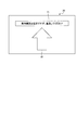
- FIG. 3 is a diagram illustrating an example of an alerting screen.
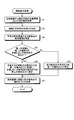
- FIG. 4 is a flowchart illustrating an example of route guidance processing according to the embodiment.
- FIG. 5 is a diagram illustrating an example of a route from the current position to the destination.
- FIG. 6 is a diagram illustrating an example of a guide sign.
- FIG. 7 is a diagram illustrating another example of the guide sign.
- FIG. 8 is a diagram illustrating another example of the guide sign.
- FIG. 9 is a diagram illustrating another example of the guide sign.
- FIG. 10 is a diagram illustrating another example of the guide sign.
- FIG. 10 is a diagram illustrating another example of the guide sign.
- FIG. 11 is a diagram illustrating another example of the guide sign.
- FIG. 12 is a diagram illustrating another example of the guide sign.
- FIG. 13 is a diagram illustrating another example of the guide sign.
- FIG. 14 is a diagram illustrating another example of the guide sign.
- FIG. 15 is a diagram illustrating another example of the guide sign.
- FIG. 16 is a diagram illustrating another example of the guide sign.
- FIG. 17 is a diagram illustrating another example of the guide sign.
- FIG. 18 is a diagram illustrating another example of the guide sign.
- FIG. 19 is a diagram illustrating another example of the guide sign.
- FIG. 20 is a diagram illustrating an example of a computer that executes a route guidance program.
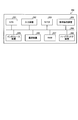
- FIG. 1 is a block diagram showing an example of the configuration of the route guidance system of the embodiment.
- a route guidance system 1 illustrated in FIG. 1 includes a terminal device 10 and an information processing device 100.
- FIG. 1 shows a case where the system has one terminal device 10 and information processing device 100, the number of terminal devices 10 and information processing devices 100 is not limited, and the route guidance system 1 can You may have the terminal device 10 and the information processing apparatus 100 of a number.
- the terminal device 10 and the information processing device 100 are connected to each other via a network N so that they can communicate with each other.
- a network N any type of communication network such as the Internet, LAN (Local Area Network), and VPN (Virtual Private Network) can be adopted regardless of wired or wireless.
- the destination and the current position input from the terminal device 10 mounted on the vehicle are transmitted to the information processing device 100, and information related to the route guidance is obtained by performing a route search or the like in the information processing device 100.
- 2 is an example of a car navigation system transmitted to a terminal device 10.
- the terminal device 10 is an information processing device that performs route guidance to a vehicle driver based on information related to route guidance acquired from the information processing device 100 and position information measured by GPS (Global Positioning System) or the like.
- the information processing apparatus 100 performs a route search based on the position information and the destination of the current position acquired from the terminal device 10, and transmits the route and guidance output at each branch point on the route to the terminal device 10. Device.
- the information processing apparatus 100 extracts a route and a destination address from the input destination. Based on the current position of the vehicle, the information processing apparatus 100 identifies a guide sign for a branch point on the route that the vehicle passes until reaching the destination. The information processing apparatus 100 stores a guide sign associated with the branch point and a place name associated with each route included in the guide sign in the storage unit. The information processing apparatus 100 refers to the storage unit, and the second route corresponding to the first route specified from the route for the branch point and the place name displayed on the guide sign that matches the place name included in the destination address. The first guidance output is output when the course matches the path.
- the information processing apparatus 100 refers to the storage unit, and the second route corresponding to the first route specified from the route for the branch point and the place name displayed on the guide sign that matches the place name included in the destination address.
- the second guidance output is output when the route does not match.
- the information processing apparatus 100 sets the first guidance output and the second guidance output to different guidance outputs. Thereby, the information processing apparatus 100 can reduce the risk of an accident due to a contradiction between the guide sign and the route guidance.
- the terminal device 10 includes a communication unit 11, a control unit 12, a display unit 13, and an operation unit 14.
- the terminal device 10 may include functional units such as various input devices and audio output devices in addition to the functional units illustrated in FIG.
- the communication unit 11 is realized by, for example, a third generation mobile communication system, a mobile phone line such as LTE (Long Term Evolution), and a communication module such as a wireless LAN.
- the communication unit 11 is a communication interface that is wirelessly connected to the information processing apparatus 100 via the network N and manages information communication with the information processing apparatus 100.
- the communication unit 11 transmits the position information of the current position and the destination input from the control unit 12 to the information processing apparatus 100. Further, the communication unit 11 receives a route and guidance output for each branch point from the information processing apparatus 100.
- the communication unit 11 outputs the received route and guidance output of each branch point to the control unit 12.
- the control unit 12 is realized, for example, by executing a program stored in an internal storage device by using a RAM (Random Access Memory) as a work area by a CPU (Central Processing Unit), an MPU (Micro Processing Unit), or the like. Is done.
- the control unit 12 may be realized by an integrated circuit such as ASIC (Application Specific Integrated Circuit) or FPGA (Field Programmable Gate Array).
- the control unit 12 receives an input of a destination from the driver who is a user of the terminal device 10 via the operation unit 14, for example.
- the control unit 12 receives the position information of the current position of the vehicle on which the terminal device 10 is mounted on the information processing apparatus 100 and the destination via the communication unit 11 and the network N. Send.
- the positional information on the current position of the vehicle on which the terminal device 10 is mounted is acquired using, for example, a GPS receiver (not shown).
- control unit 12 receives the route and guidance output of each branch point from the information processing apparatus 100 via the network N and the communication unit 11.
- the control unit 12 displays guidance information based on the route on the display unit 13.
- the control unit 12 displays the guidance output at the branch point on the display unit 13 and outputs the voice of the guidance output at the branch point to a speaker (not shown).
- the control unit 12 determines that the first route, that is, the second route if the first route based on the route matches the second route based on the place name of the road sign.
- a first guidance output for proceeding to the course of is displayed on the display unit 13.
- the control part 12 outputs the audio
- the control unit 12 displays a second guidance output indicating that the route proceeds to the first route on the display unit 13.
- the control part 12 outputs the audio
- the second guidance output alerts the driver so that the route of the route guidance is different from the route of the guidance sign, but the route of the route guidance is advanced.
- the control unit 12 periodically transmits the position information of the current position of the vehicle to the information processing apparatus 100 at predetermined time intervals, and receives the guidance output of the branch point close to the current position of the vehicle from the information processing apparatus 100. You may make it do.
- the predetermined time interval may be, for example, every minute.
- the control unit 12 may periodically transmit the position information of the current position of the vehicle to the information processing apparatus 100 at predetermined time intervals to update the route and the guidance output of each branch point.
- the display unit 13 is a display device for displaying various information.
- the display unit 13 is realized by, for example, a liquid crystal display as a display device.
- the display unit 13 displays various screens such as a display screen input from the control unit 12.
- the operation unit 14 is an input device that receives various operations from a driver who is a user of the terminal device 10.
- the operation unit 14 is realized by, for example, a touch panel as an input device.
- the input device of the operation unit 14 may be integrated with a liquid crystal display which is an example of the display device of the display unit 13.
- the operation unit 14 outputs an operation input by the driver to the control unit 12 as operation information.
- the operation unit 14 may be realized by another input device such as a switch or a remote controller.
- the information processing apparatus 100 includes a communication unit 110, a display unit 111, an operation unit 112, a storage unit 120, and a control unit 130.
- the information processing apparatus 100 may include functional units such as various input devices and audio output devices in addition to the functional units illustrated in FIG.
- the communication unit 110 is realized by, for example, a third generation mobile communication system, a mobile phone line such as LTE, and a communication module such as a wireless LAN.
- the communication unit 110 is a communication interface that is wirelessly connected to the terminal device 10 via the network N and manages information communication with the terminal device 10.
- the communication unit 110 receives the position information and the destination of the current position from the terminal device 10.
- the communication unit 110 outputs the received position information of the current position and the destination to the control unit 130.
- the communication unit 110 transmits the route input from the control unit 130 and the guidance output of each branch point to the terminal device 10.
- the display unit 111 is a display device for displaying various information.
- the display unit 111 is realized by, for example, a liquid crystal display as a display device.
- the display unit 111 displays various screens such as a display screen input from the control unit 130.
- the operation unit 112 is an input device that receives various operations from the administrator of the information processing apparatus 100.
- the operation unit 112 is realized by, for example, a keyboard or a mouse as an input device.
- the operation unit 112 outputs an operation input by the administrator to the control unit 130 as operation information.
- the operation unit 112 may be realized by a touch panel or the like as an input device, and the display device of the display unit 111 and the input device of the operation unit 112 may be integrated.
- the storage unit 120 is realized by, for example, a semiconductor memory device such as a RAM or a flash memory, or a storage device such as a hard disk or an optical disk.
- the storage unit 120 includes a map database 121 (hereinafter also referred to as a map DB 121) and a guide sign storage unit 122.
- the storage unit 120 stores information used for processing in the control unit 130.
- the map DB 121 is a map database for searching a route to the destination based on the position information of the current position acquired from the terminal device 10 and the destination. Moreover, map DB121 memorize
- the guide sign storage unit 122 stores information on the guide sign associated with the branch point.
- FIG. 2 is a diagram illustrating an example of a guide sign storage unit. As shown in FIG. 2, the guide sign storage unit 122 includes “branch point ID (IDentifier)”, “road”, “guide sign ID”, “guide sign”, “important place”, “main place or important place”. , “Left side”, “Right side”.
- the “branch point ID” is an identifier for identifying a road branch point on the route extracted from the map DB 121.
- “Road” is information indicating the name of a road through which a route passes at a branch point.
- “Guidance sign ID” is an identifier for identifying a guidance sign regarding a branch point.
- “Guidance sign” is information indicating the type of the guidance sign.
- the “important place” is information indicating a reference place or an important place that is closest in the straight direction in the guide sign.
- “Main or important place” is information indicating the closest main or important place in the straight direction in the guide sign.
- “Left side” is information indicating a main place or the like on the left side of the guide sign in the straight direction.
- “Right side” is information indicating a main place or the like that is on the right side of the straight direction in the guide sign. Depending on the guide sign, the important place, the left side and the right side may not
- the guidance sign ID “B001-1” of “National highway No. 15” at the branch point ID “B001” has the type of guidance sign “108-A”, “Yokohama” and “Kawasaki” are displayed.
- “Haneda” is displayed in the left turn direction
- “Shimomaruko” is displayed in the right turn direction.
- control unit 130 is realized by, for example, a CPU or MPU executing a program stored in an internal storage device using the RAM as a work area.
- the control unit 130 may be realized by an integrated circuit such as ASIC or FPGA, for example.
- the control unit 130 includes an extraction unit 131, a specification unit 132, and a guidance output unit 133, and realizes or executes information processing functions and operations described below. Note that the internal configuration of the control unit 130 is not limited to the configuration illustrated in FIG. 1, and may be another configuration as long as the information processing described below is performed.
- the extraction unit 131 receives the position information and the destination of the current position from the terminal device 10 via the network N and the communication unit 110.
- the extraction unit 131 refers to the map DB 121 and extracts the route to the destination and the address of the destination based on the received location information and the destination. That is, the extraction unit 131 performs a route search from the current position to the destination based on the position information of the current position and the destination, and extracts the route to the destination and the address of the destination.
- the extraction unit 131 outputs the extracted route and destination address and the position information of the current position to the specifying unit 132 and the guidance output unit 133.
- the specifying unit 132 refers to the map DB 121 and branches on the route through which the vehicle passes to the destination. Identify the guide signs.
- the identification unit 132 outputs the guidance sign ID of the guidance sign at the identified branch point to the guidance output unit 133.
- the guidance output unit 133 receives the route and destination address from the extraction unit 131 and the current position information.
- the guidance output ID 133 is inputted with the guidance sign ID of the branch point from the specifying unit 132.
- the guidance output unit 133 refers to the guidance sign storage unit 122 and, based on the route and the guidance sign ID, the first route specified from the route at the branch point and the name of the guidance sign that matches the place name of the destination address. It is determined whether there is a branch point that does not match the second route corresponding to the place name. When there is no branch point where the first route and the second route do not match, the guide output unit 133 sets the guide output at each branch point to the first guide output.
- the guidance output unit 133 sets the guide output of the matching branch point to the first guide output, and guides the branch point that does not match. Set the output to the second guidance output.
- the second guidance output is a guidance output indicating that the first route is prioritized over the second route.
- the guidance output unit 133 transmits the route and the guidance output of each branch point where the first guidance output or the second guidance output is set to the terminal device 10 via the communication unit 110 and the network N. In addition, the guidance output unit 133 transmits, to the terminal device 10 together with the second guidance output, one or more of the voice and the screen display for calling attention as the guidance output of the branch point where the second guidance output is set. To do.
- the guidance output unit 133 refers to the guidance sign storage unit 122 and is displayed on the guidance sign that matches the first route specified from the route for the branch point and the place name included in the destination address.
- a first guidance output is output when the second route corresponding to the place name matches.
- the guidance output unit 133 refers to the guidance sign storage unit 122, and the place name displayed on the first course specified from the route for the branch point and the place sign included in the place name included in the destination address.
- a second guidance output is output when the second course corresponding to the line does not match.
- the guidance output unit 133 changes the first guidance output and the second guidance output to different guidance outputs when outputting the guidance output.
- FIG. 3 is a diagram illustrating an example of an alerting screen.
- a display screen 20 illustrated in FIG. 3 is an example of a warning screen that is transmitted from the information processing device 100 to the terminal device 10 and displayed on the display unit 13 of the terminal device 10.
- the display screen 20 is displayed when the route of the name of the destination of the guidance sign installed on the road is different from the route in the route guidance at the branch point.
- FIG. 4 is a flowchart illustrating an example of route guidance processing according to the embodiment.
- control unit 12 of the terminal device 10 When the control unit 12 of the terminal device 10 receives the input of the destination from the driver, the control unit 12 transmits the position information of the current position of the vehicle and the destination to the information processing device 100.
- the extraction unit 131 of the information processing apparatus 100 receives and acquires the position information and the destination of the current position from the terminal device 10 (step S1).
- the extraction unit 131 refers to the map DB 121 and extracts the route to the destination and the address of the destination based on the acquired current position information and the destination (step S2).
- the extraction unit 131 outputs the extracted route and destination address and the position information of the current position to the specifying unit 132 and the guidance output unit 133.
- the specifying unit 132 refers to the map DB 121 and branches on the route through which the vehicle passes to the destination. Is identified (step S3).
- the identification unit 132 outputs the guidance sign ID of the guidance sign at the identified branch point to the guidance output unit 133.
- the guidance output unit 133 refers to the guidance sign storage unit 122 and determines whether there is a branch point where the first route and the second route do not match based on the route and the guidance sign ID (step) S4). When there is no branch point where the first route and the second route do not match (No at Step S4), the guide output unit 133 sets the guide output at each branch point to the first guide output (Step S4). S5).
- the guidance output unit 133 sets the guide output of the matching branch point as the first guide output, The guidance output at the branch point that does not match is set as the second guidance output (step S6).
- the guidance output unit 133 transmits the route and the guidance output of each branch point where the first guidance output or the second guidance output is set to the terminal device 10 (step S7).
- the control unit 12 of the terminal device 10 receives the guidance output of the route and each branch point, the control information is displayed on the display unit 13 based on the route. Further, when the vehicle reaches the branch point, the control unit 12 displays the guidance output at the branch point on the display unit 13 and outputs the voice of the guidance output at the branch point to a speaker (not shown). Thereby, the information processing apparatus 100 can reduce the risk of an accident due to a contradiction between the guide sign and the route guidance.
- FIG. 5 is a diagram illustrating an example of a route from the current position to the destination.
- a map 30 shown in FIG. 5 shows an example of a route 33 from a current position 31 to a destination 32 of a certain vehicle.
- the vehicle is about to move from the vicinity of Kamata on National Route 15 which is the current position 31 to Ichigao in Yokohama city which is the destination 32.
- the guide signs from the point A to the point F on the route 33 and the route guidance will be described along the route 33.
- FIG. 6 is a diagram showing an example of a guide sign. 7 to 19 are diagrams showing other examples of the guide sign.
- “Ichigao” is input from the driver to the terminal device 10 of the vehicle as a destination.
- the terminal device 10 transmits the position information “Iwata” of the current position of the vehicle and the destination “Ichigao” to the information processing apparatus 100.
- the information processing apparatus 100 receives the position information “Iwata” and the destination “Ichigao” of the current position from the terminal device 10.
- the information processing apparatus 100 searches for a route, extracts a guidance sign for a branch point on the route 33, and sets a guidance output for each branch point, and transmits the route 33 and the guidance output for each branch point to the terminal device 10. .
- the terminal device 10 When the terminal device 10 receives the guidance output of the route 33 and each branch point, the terminal device 10 displays guidance information based on the route 33 on the display unit 13 and starts route guidance. When the route guidance is started, the driver leaves the vehicle toward the destination “Ichigao”.
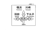
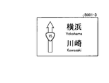
- a guide sign B001-1 shown in FIG. 6 appears.
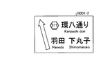
- a guidance sign B001-2 shown in FIG. 7 and a guidance sign B001-3 shown in FIG. 8 are visible.
- Guide sign B001-2 and guide sign B001-3 are installed on the same pedestrian bridge, the lane that branches to the left corresponds to the guide sign B001-2, and the straight lane corresponds to the guide sign B001-3 .
- the first route specified from the route 33 is straight, and the second route corresponding to the place name “Yokohama” included in the destination address in the guide signs B001-1 and B001-3 is straight. . Therefore, the first route matches the second route, and the guidance output at the branch point becomes the first guidance output that is normal route guidance.
- the first guidance output in this case is, for example, guidance such as “Following straight ahead”.
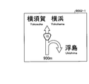
- a guide sign B002-1 shown in FIG. 9 and a guide sign B002-2 shown in FIG. 10 appear.
- the guide sign B002-1 and the guide sign B002-2 are installed on the same gate-type column, and the leftmost lane of the three lanes corresponds to the guide sign B002-2.
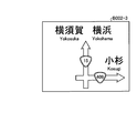
- point B is an intersection of a three-dimensional intersection, and a ramp is provided to turn right and left, and there is a guide sign B002-3 shown in FIG. 11 near the intersection under the three-dimensional intersection.
- the first route specified from the route 33 turns right at the intersection under the three-dimensional intersection through the ramp from the main line, and the second route corresponding to the place name “Yokohama” of the guide sign B002-1 is straight ahead.
- the route guidance is, for example, “Go diagonally to the left and turn right at the intersection ahead”, and “Yokohama” of the guidance sign B002-1 and the guidance sign B002-3 is straight ahead.
- the route of the guidance sign There is a contradiction between the route of the guidance sign and the route of the route guidance. For this reason, the driver may be confused about where to proceed and the risk of accidents may increase.
- the driver goes straight according to the guidance sign, as shown by the dotted line 34 in FIG. 5, the driver proceeds toward Yokohama Station, which is the center of “Yokohama”, and becomes a detour to “Ichigao”. May end up.
- the second guidance output in this case is, for example, guidance such as “The guidance sign is going straight, but go diagonally left and turn right at the intersection ahead”. Moreover, in the terminal device 10, you may make it display a warning screen and to play a warning sound. Furthermore, the second guidance output is, for example, “Guide sign is straight, but go diagonally left, go to Kosugi, turn right at the next intersection and go to Kosugi,” and so on. May be included.
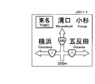
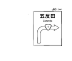
- a guide sign B011-1 shown in FIG. 12 appears.
- a guidance sign B011-2 shown in FIG. 13 a guidance sign B011-3 shown in FIG. 14, and a guidance sign B011-4 shown in FIG. 15 become visible.
- the guide sign B011-2, the guide sign B011-3, and the guide sign B011-4 are installed on the same pedestrian bridge, and the guide sign B011-2 and the guide sign B011-3 are sequentially arranged from the left in the three lanes. , And the guide sign B011-4.
- the first route specified from the route 33 is going straight, and the second route corresponding to the place name “Yokohama” of the guide sign B011-1 and the guide sign B011-2 is a left turn.
- the second guidance output in this case is, for example, guidance such as “Guide sign turns left, but go straight”.
- the terminal device 10 may display a warning screen and play a warning sound.
- the second guidance output may include the place name of the waypoint, for example, “The guidance sign is a left turn, but please go straight toward Kosugi.”
- the driver turns left following the guidance sign, as shown by the dotted line 35 in FIG. There is a case where it becomes a detour to go to "Ichigao".
- a guidance sign B021-1 shown in FIG. 16 appears.
- the first course specified from the route 33 is a left turn.
- the place names “Atsugi” and “Tomei” on the left turn side of the guide sign B021-1 are different from Yokohama, but in the direction of Kanagawa Prefecture.
- the place names “Fuchu” and “Inagi” on the straight ahead side, and the place names “Atsugi” on the right turn side “ "Shibuya” is for Tokyo.
- the driver is likely to determine that the direction of “Atsugi” is close to Yokohama, so the second course corresponding to the place name “Atsugi” of the guide sign B021-1 is a left turn. Therefore, the first route matches the second route, and the guidance output at the branch point becomes the first guidance output that is normal route guidance.
- the first guidance output in this case is, for example, guidance such as “Further left turn”.
- the first route specified from the route 33 is straight ahead
- the second route corresponding to the place name “Ichigao” included in the destination address in the guide sign B022-1 is straight ahead. Therefore, the first route matches the second route, and the guidance output at the branch point becomes the first guidance output that is normal route guidance.
- the first guidance output in this case is, for example, guidance such as “Following straight ahead”.
- a guidance sign B025-1 shown in FIG. 18 appears.
- a guidance sign B025-2 shown in FIG. 19 appears. “Atsugi” and “Ichigao” as the destination are displayed in the straight direction on the guide signs B025-1 and B025-2.
- the first route specified from the route 33 is straight ahead, and the second route corresponding to the place name “Ichigao” included in the destination address in the guide signs B025-1 and B025-2 is straight ahead. . Therefore, the first route matches the second route, and the guidance output at the branch point becomes the first guidance output that is normal route guidance.
- the first guidance output in this case is, for example, guidance such as “Following straight ahead”.
- the terminal device 10 performs route guidance in the same manner, and ends the route guidance when the vehicle arrives at Ichigao.
- the information processing apparatus 100 extracts the route and the address of the destination from the input destination. Further, the information processing apparatus 100 specifies a guidance sign for a branch point on a route through which the vehicle passes to the destination based on the current position of the vehicle. In addition, the information processing apparatus 100 stores in the guide sign storage unit 122 a guide sign associated with the branch point and a place name associated with each route included in the guide sign. In addition, the information processing apparatus 100 refers to the guide sign storage unit 122, and the place name displayed on the first sign specified from the route for the branch point and the place sign included in the place name included in the destination address The first guidance output is output when the second course corresponding to the line matches.
- the information processing apparatus 100 refers to the guide sign storage unit 122, and the place name displayed on the first sign specified from the route for the branch point and the place sign included in the place name included in the destination address A second guidance output is output when the second course corresponding to the line does not match. Further, when outputting the guidance output, the information processing apparatus 100 sets the first guidance output and the second guidance output to different guidance outputs. As a result, it is possible to reduce the risk of accidents caused by contradictions between the guide signs and route guidance.
- the second guidance output is a guidance output indicating that the first route has priority over the second route.
- the information processing apparatus 100 outputs one or more of the voice and the screen display for calling attention together with the second guidance output. As a result, driver confusion can be further suppressed.
- the route search was performed in the information processing apparatus 100, it is not limited to this.
- it monitors other information processing devices that perform route search, acquires a route and a destination that are a result of the route search performed by another information processing device, and based on the acquired route and destination, Route guidance processing may be performed.
- the guidance output at each branch point is set at the time of departure, but the present invention is not limited to this.
- a guidance output of a branch point approaching the current position may be set as appropriate based on the current position of movement and transmitted from the information processing apparatus 100 to the terminal apparatus 10.
- the present invention is not limited to this.
- the route and the guide sign are different from each other, or the guide sign is a route passing through the living road, but the present invention can also be applied when avoiding the living road.
- the route guidance process is performed by the information processing apparatus 100, and the route and the guidance output of each branch point are transmitted to the terminal device 10.
- the present invention is not limited to this.
- the map DB 121 and the guidance sign storage unit 122 may be provided in the terminal device 10 and the route guidance processing may be performed in the terminal device 10.
- each component of each part illustrated does not necessarily need to be physically configured as illustrated.
- the specific form of distribution / integration of each unit is not limited to that shown in the figure, and all or a part thereof may be functionally or physically distributed / integrated in arbitrary units according to various loads or usage conditions. Can be configured.
- the specifying unit 132 and the guidance output unit 133 may be integrated.
- the illustrated processes are not limited to the above-described order, and may be performed at the same time as long as the process contents are not contradictory, or may be performed in a different order.
- processing functions performed in each device may be executed entirely or arbitrarily on a CPU (or a microcomputer such as an MPU or MCU (Micro Controller Unit)).
- various processing functions may be executed in whole or in any part on a program that is analyzed and executed by a CPU (or a microcomputer such as an MPU or MCU) or on hardware based on wired logic. Needless to say, it is good.
- FIG. 20 is a diagram illustrating an example of a computer that executes a route guidance program.
- the computer 200 includes a CPU 201 that executes various arithmetic processes, an input device 202 that receives data input, and a monitor 203.
- the computer 200 also includes a medium reading device 204 that reads a program and the like from a storage medium, an interface device 205 for connecting to various devices, and a communication device 206 for connecting to other information processing devices and the like by wire or wirelessly.
- the computer 200 also includes a RAM 207 that temporarily stores various types of information and a hard disk device 208.
- the devices 201 to 208 are connected to a bus 209.
- the hard disk device 208 stores a route guidance program having the same functions as the processing units of the extraction unit 131, the identification unit 132, and the guidance output unit 133 shown in FIG.
- the hard disk device 208 also stores a map DB 121, a guide sign storage unit 122, and various data for realizing a route guidance program.
- the input device 202 has a function similar to that of the operation unit 112 illustrated in FIG. 1, for example, and receives input of various types of information such as operation information from the administrator of the computer 200.
- the monitor 203 displays various screens such as a display screen for the administrator of the computer 200, for example.
- the interface device 205 is connected to, for example, a printing device.
- the communication device 206 has the same function as the communication unit 110 illustrated in FIG. 1, is connected to the terminal device 10, and exchanges various information with the terminal device 10.
- the CPU 201 reads out each program stored in the hard disk device 208, develops it in the RAM 207, and executes it to perform various processes. Further, these programs can cause the computer 200 to function as the extraction unit 131, the identification unit 132, and the guidance output unit 133 illustrated in FIG.
- the above route guidance program is not necessarily stored in the hard disk device 208.
- the computer 200 may read and execute a program stored in a storage medium readable by the computer 200.
- the storage medium readable by the computer 200 corresponds to, for example, a portable recording medium such as a CD-ROM, a DVD disk, a USB (Universal Serial Bus) memory, a semiconductor memory such as a flash memory, and a hard disk drive.
- the route guidance program may be stored in a device connected to a public line, the Internet, a LAN, etc., and the computer 200 may read and execute the route guidance program therefrom.
Landscapes
- Engineering & Computer Science (AREA)
- Radar, Positioning & Navigation (AREA)
- Remote Sensing (AREA)
- Automation & Control Theory (AREA)
- Physics & Mathematics (AREA)
- General Physics & Mathematics (AREA)
- Navigation (AREA)
Abstract
案内標識と経路案内の矛盾による事故リスクを低減できること。経路案内プログラムは、コンピュータ(200)に以下の各処理を実行させる。コンピュータは、入力された目的地から経路と目的地の住所とを抽出する。コンピュータは、車両の現在位置に基づき目的地までに通過する経路上の分岐地点についての案内標識を特定する。コンピュータは、記憶部に分岐地点に対応付けた案内標識と案内標識に含まれる各進路に対応付けた地名とを記憶する。コンピュータは、記憶部を参照して、分岐地点について経路から特定される第一の進路と、目的地の住所の地名と一致する案内標識に表示された地名に対応する第二の進路とが合致する場合に第一の案内出力を出力する。コンピュータは、第一の進路と第二の進路とが合致しない場合に第二の案内出力を出力する。コンピュータは、案内出力を出力する際に、第一の案内出力と第二の案内出力とを異なる案内出力にする。
Description
本発明は、経路案内プログラム、経路案内方法および情報処理装置に関する。
カーナビゲーションシステムは、車両に搭載されて、ドライバーが知らない土地でも目的地に到達する経路を音声や画面表示により案内する。カーナビゲーションシステムは、例えば、車両が交差点に差し掛かると、目的地への経路に応じた進路を案内する。
しかしながら、交差点の案内標識に記載された目的地への進路と、カーナビゲーションシステムが案内する目的地への進路とが異なっている場合がある。この場合、ドライバーは、案内標識とカーナビゲーションシステムの経路案内とが矛盾しているので、どちらが正しいのか混乱してしまい、例えば、前方不注意等の事故リスクが増大する場合がある。
一つの側面では、本発明は、案内標識と経路案内の矛盾による事故リスクを低減できる経路案内プログラム、経路案内方法および情報処理装置を提供することにある。
一つの態様では、経路案内プログラムは、コンピュータに以下の各処理を実行させる。コンピュータは、入力された目的地から経路と目的地の住所とを抽出する。コンピュータは、車両の現在位置に基づいて、車両が目的地に至るまでに通過する経路上の分岐地点についての案内標識を特定する。コンピュータは、記憶部に分岐地点に対応付けた案内標識と案内標識に含まれる各進路に対応付けた地名とを記憶する。コンピュータは、記憶部を参照して、分岐地点について経路から特定される第一の進路と、目的地の住所に含まれる地名と一致する案内標識に表示された地名に対応する第二の進路とが合致する場合に第一の案内出力を出力する。コンピュータは、記憶部を参照して、分岐地点について経路から特定される第一の進路と、目的地の住所に含まれる地名と一致する案内標識に表示された地名に対応する第二の進路とが合致しない場合に第二の案内出力を出力する。コンピュータは、案内出力を出力する際に、第一の案内出力と、第二の案内出力とを異なる案内出力にする。
案内標識と経路案内の矛盾による事故リスクを低減できる。
以下、図面に基づいて、本願の開示する経路案内プログラム、経路案内方法および情報処理装置の実施例を詳細に説明する。なお、本実施例により、開示技術が限定されるものではない。また、以下の実施例は、矛盾しない範囲で適宜組みあわせてもよい。
図1は、実施例の経路案内システムの構成の一例を示すブロック図である。図1に示す経路案内システム1は、端末装置10と、情報処理装置100とを有する。なお、図1には、システムが1つの端末装置10および情報処理装置100を有する場合を示したが、端末装置10および情報処理装置100の数は限定されず、経路案内システム1は、任意の数の端末装置10および情報処理装置100を有してもよい。
端末装置10および情報処理装置100の間は、ネットワークNを介して相互に通信可能に接続される。かかるネットワークNには、有線または無線を問わず、インターネットを始め、LAN(Local Area Network)やVPN(Virtual Private Network)などの任意の種類の通信網を採用できる。
経路案内システム1は、車両に搭載される端末装置10で入力された目的地と現在位置とが情報処理装置100に送信され、情報処理装置100で経路探索等を行って経路案内に係る情報が端末装置10に送信されるカーナビゲーションシステムの一例である。端末装置10は、情報処理装置100から取得した経路案内に係る情報と、GPS(Global Positioning System)等で測位した位置情報とに基づいて、車両のドライバーに経路案内を行う情報処理装置である。情報処理装置100は、端末装置10から取得した現在位置の位置情報および目的地に基づいて経路探索を行い、経路と、経路上の各分岐地点における案内出力とを端末装置10に送信する情報処理装置である。
情報処理装置100は、入力された目的地から経路と目的地の住所とを抽出する。情報処理装置100は、車両の現在位置に基づいて、車両が目的地に至るまでに通過する経路上の分岐地点についての案内標識を特定する。情報処理装置100は、記憶部に分岐地点に対応付けた案内標識と案内標識に含まれる各進路に対応付けた地名とを記憶する。情報処理装置100は、記憶部を参照して、分岐地点について経路から特定される第一の進路と、目的地の住所に含まれる地名と一致する案内標識に表示された地名に対応する第二の進路とが合致する場合に第一の案内出力を出力する。情報処理装置100は、記憶部を参照して、分岐地点について経路から特定される第一の進路と、目的地の住所に含まれる地名と一致する案内標識に表示された地名に対応する第二の進路とが合致しない場合に第二の案内出力を出力する。情報処理装置100は、案内出力を出力する際に、第一の案内出力と、第二の案内出力とを異なる案内出力にする。これにより、情報処理装置100は、案内標識と経路案内の矛盾による事故リスクを低減できる。
次に、端末装置10の構成について説明する。図1に示すように、端末装置10は、通信部11と、制御部12と、表示部13と、操作部14とを有する。なお、端末装置10は、図1に示す機能部以外にも、例えば各種の入力デバイスや音声出力デバイス等の機能部を有することとしてもかまわない。
通信部11は、例えば、第3世代移動通信システム、LTE(Long Term Evolution)等の携帯電話回線および無線LAN等の通信モジュール等によって実現される。通信部11は、ネットワークNを介して情報処理装置100と無線で接続され、情報処理装置100との間で情報の通信を司る通信インタフェースである。通信部11は、制御部12から入力された現在位置の位置情報および目的地を情報処理装置100に送信する。また、通信部11は、情報処理装置100から経路および各分岐地点の案内出力を受信する。通信部11は、受信した経路および各分岐地点の案内出力を制御部12に出力する。
制御部12は、例えば、CPU(Central Processing Unit)やMPU(Micro Processing Unit)等によって、内部の記憶装置に記憶されているプログラムがRAM(Random Access Memory)を作業領域として実行されることにより実現される。また、制御部12は、例えば、ASIC(Application Specific Integrated Circuit)やFPGA(Field Programmable Gate Array)等の集積回路により実現されるようにしてもよい。
制御部12は、例えば、端末装置10のユーザであるドライバーから、目的地の入力を、操作部14を介して受け付ける。制御部12は、目的地の入力を受け付けると、通信部11およびネットワークNを介して、情報処理装置100に対して端末装置10が搭載された車両の現在位置の位置情報と、目的地とを送信する。なお、端末装置10が搭載された車両の現在位置の位置情報は、例えば、図示しないGPS受信機を用いて取得する。
また、制御部12は、情報処理装置100から、ネットワークNおよび通信部11を介して、経路および各分岐地点の案内出力を受信する。制御部12は、経路および各分岐地点の案内出力を受信すると、経路に基づく案内情報を表示部13に表示する。また、制御部12は、車両が分岐地点に差し掛かると、当該分岐地点における案内出力を表示部13に表示するとともに、当該分岐地点の案内出力の音声を図示しないスピーカに出力する。
制御部12は、車両が分岐地点に差し掛かった際に、経路に基づく第一の進路と、道路標識の地名に基づく第二の進路とが合致する場合には、第一の進路、つまり第二の進路に進む旨の第一の案内出力を表示部13に表示する。また、制御部12は、第一の案内出力の音声を図示しないスピーカに出力する。これに対し、制御部12は、第一の進路と、第二の進路とが合致しない場合には、第一の進路に進む旨の第二の案内出力を表示部13に表示する。また、制御部12は、第二の案内出力の音声を図示しないスピーカに出力する。このとき、第二の案内出力は、ドライバーに対して、経路案内の進路と、案内標識の進路とが異なるが、経路案内の進路を進むように注意喚起を行うものである。
なお、制御部12は、車両の現在位置の位置情報を所定の時間間隔で定期的に情報処理装置100に送信して、車両の現在位置に近い分岐地点の案内出力を情報処理装置100から受信するようにしてもよい。なお、所定の時間間隔は、例えば、1分ごととすることができる。また、制御部12は、車両の現在位置の位置情報を所定の時間間隔で定期的に情報処理装置100に送信して、経路および各分岐地点の案内出力を更新するようにしてもよい。
表示部13は、各種情報を表示するための表示デバイスである。表示部13は、例えば、表示デバイスとして液晶ディスプレイ等によって実現される。表示部13は、制御部12から入力された表示画面等の各種画面を表示する。
操作部14は、端末装置10のユーザであるドライバーから各種操作を受け付ける入力デバイスである。操作部14は、例えば、入力デバイスとして、タッチパネル等によって実現される。この場合、操作部14の入力デバイスは、表示部13の表示デバイスの一例である液晶ディスプレイと一体化されるようにしてもよい。操作部14は、ドライバーによって入力された操作を操作情報として制御部12に出力する。なお、操作部14は、スイッチやリモートコントローラ等の他の入力デバイスによって実現されるようにしてもよい。
続いて、情報処理装置100の構成について説明する。図1に示すように、情報処理装置100は、通信部110と、表示部111と、操作部112と、記憶部120と、制御部130とを有する。なお、情報処理装置100は、図1に示す機能部以外にも、例えば各種の入力デバイスや音声出力デバイス等の機能部を有することとしてもかまわない。
通信部110は、例えば、第3世代移動通信システム、LTE等の携帯電話回線および無線LAN等の通信モジュール等によって実現される。通信部110は、ネットワークNを介して端末装置10と無線で接続され、端末装置10との間で情報の通信を司る通信インタフェースである。通信部110は、端末装置10から現在位置の位置情報および目的地を受信する。通信部110は、受信した現在位置の位置情報および目的地を制御部130に出力する。また、通信部110は、制御部130から入力された経路および各分岐地点の案内出力を端末装置10に送信する。
表示部111は、各種情報を表示するための表示デバイスである。表示部111は、例えば、表示デバイスとして液晶ディスプレイ等によって実現される。表示部111は、制御部130から入力された表示画面等の各種画面を表示する。
操作部112は、情報処理装置100の管理者から各種操作を受け付ける入力デバイスである。操作部112は、例えば、入力デバイスとして、キーボードやマウス等によって実現される。操作部112は、管理者によって入力された操作を操作情報として制御部130に出力する。なお、操作部112は、入力デバイスとして、タッチパネル等によって実現されるようにしてもよく、表示部111の表示デバイスと、操作部112の入力デバイスとは、一体化されるようにしてもよい。
記憶部120は、例えば、RAM、フラッシュメモリ(Flash Memory)等の半導体メモリ素子、ハードディスクや光ディスク等の記憶装置によって実現される。記憶部120は、地図データベース121(以下、地図DB121ともいう。)と、案内標識記憶部122とを有する。また、記憶部120は、制御部130での処理に用いる情報を記憶する。
地図DB121は、端末装置10から取得した現在位置の位置情報と目的地とに基づいて、目的地までの経路を検索するための地図データベースである。また、地図DB121は、地図に対応付けられた住所を記憶する。
案内標識記憶部122は、分岐地点に対応付けられた案内標識の情報を記憶する。図2は、案内標識記憶部の一例を示す図である。図2に示すように、案内標識記憶部122は、「分岐地点ID(IDentifier)」、「道路」、「案内標識ID」、「案内標識」、「重要地」、「主要地または重要地」、「左側」、「右側」といった項目を有する。
「分岐地点ID」は、地図DB121から抽出された経路上における道路の分岐地点を識別する識別子である。「道路」は、分岐地点において経路が通る道路の名称を示す情報である。「案内標識ID」は、分岐地点に関する案内標識を識別する識別子である。「案内標識」は、案内標識の種別を示す情報である。「重要地」は、案内標識において、直進方向の最も近い基準地または重要地を示す情報である。「主要地または重要地」は、案内標識において、直進方向の最も近い主要地または重要地を示す情報である。「左側」は、案内標識において、直進方向よりも左側にある主要地等を示す情報である。「右側」は、案内標識において、直進方向よりも右側にある主要地等を示す情報である。なお、案内標識によっては、重要地、左側および右側は表示されない場合がある。
図2の1行目の例では、分岐地点ID「B001」における「国道15号」の案内標識ID「B001-1」は、案内標識の種別が「108-A」であり、直進方向に「横浜」および「川崎」が表示されることを示す。また、図2の1行目の例では、左折方向に「羽田」が表示され、右折方向に「下丸子」が表示されることを示す。
図1の説明に戻って、制御部130は、例えば、CPUやMPU等によって、内部の記憶装置に記憶されているプログラムがRAMを作業領域として実行されることにより実現される。また、制御部130は、例えば、ASICやFPGA等の集積回路により実現されるようにしてもよい。制御部130は、抽出部131と、特定部132と、案内出力部133とを有し、以下に説明する情報処理の機能や作用を実現または実行する。なお、制御部130の内部構成は、図1に示した構成に限られず、後述する情報処理を行う構成であれば他の構成であってもよい。
抽出部131は、ネットワークNおよび通信部110を介して、端末装置10から現在位置の位置情報および目的地を受信する。抽出部131は、地図DB121を参照し、受信して入力された現在位置の位置情報および目的地に基づいて、目的地への経路と目的地の住所とを抽出する。すなわち、抽出部131は、現在位置の位置情報および目的地に基づいて、現在位置から目的地への経路探索を行って、目的地への経路と目的地の住所とを抽出する。抽出部131は、抽出した経路および目的地の住所と、現在位置の位置情報とを、特定部132および案内出力部133に出力する。
特定部132は、抽出部131から経路および目的地の住所と、現在位置の位置情報とが入力されると、地図DB121を参照し、車両が目的地に至るまでに通過する経路上の分岐地点の案内標識を特定する。特定部132は、特定した分岐地点の案内標識の案内標識IDを案内出力部133に出力する。
案内出力部133には、抽出部131から経路および目的地の住所と、現在位置の位置情報とが入力される。また、案内出力部133には、特定部132から分岐地点の案内標識IDが入力される。案内出力部133は、案内標識記憶部122を参照し、経路と案内標識IDとに基づき、分岐地点における経路から特定される第一の進路と、目的地の住所の地名と一致する案内標識の地名に対応する第二の進路とが合致しない分岐地点があるか否かを判定する。案内出力部133は、第一の進路と第二の進路とが合致しない分岐地点がない場合には、各分岐地点の案内出力を第一の案内出力に設定する。
案内出力部133は、第一の進路と第二の進路とが合致しない分岐地点がある場合には、合致する分岐地点の案内出力を第一の案内出力に設定し、合致しない分岐地点の案内出力を第二の案内出力に設定する。ここで、第二の案内出力は、第二の進路よりも第一の進路を優先する旨の案内出力である。
案内出力部133は、経路と、第一の案内出力または第二の案内出力が設定された各分岐地点の案内出力とを、通信部110およびネットワークNを介して、端末装置10に送信する。また、案内出力部133は、第二の案内出力が設定された分岐地点の案内出力として、注意喚起を促す音声および画面表示のうち1つ以上を、第二の案内出力とともに端末装置10に送信する。
言い換えると、案内出力部133は、案内標識記憶部122を参照して、分岐地点について経路から特定される第一の進路と、目的地の住所に含まれる地名と一致する案内標識に表示された地名に対応する第二の進路とが合致する場合に第一の案内出力を出力する。また、案内出力部133は、案内標識記憶部122を参照して、分岐地点について経路から特定される第一の進路と、目的地の住所に含まれる地名と一致する案内標識に表示された地名に対応する第二の進路とが合致しない場合に第二の案内出力を出力する。案内出力部133は、案内出力を出力する際に、第一の案内出力と、第二の案内出力とを異なる案内出力にする。
ここで、図3を用いて注意喚起を促す画面表示について説明する。図3は、注意喚起画面の一例を示す図である。図3に示す表示画面20は、情報処理装置100から端末装置10に送信され、端末装置10の表示部13に表示される注意喚起画面の一例である。表示画面20は、分岐地点において、道路に設置されている案内標識の目的地の地名の進路と、経路案内における進路とが異なる場合に表示される。表示画面20には、例えば、案内標識における進路が左折であり、経路案内における進路が直進である場合には、「案内標識は左折ですが、直進してください!」といったメッセージ21と、直進を示す矢印22とが表示される。
次に、実施例の経路案内システム1の動作について説明する。図4は、実施例の経路案内処理の一例を示すフローチャートである。
端末装置10の制御部12は、ドライバーから目的地の入力を受け付けると、情報処理装置100に対して車両の現在位置の位置情報と、目的地とを送信する。情報処理装置100の抽出部131は、端末装置10から現在位置の位置情報および目的地を受信して取得する(ステップS1)。
抽出部131は、地図DB121を参照し、取得した現在位置の位置情報および目的地に基づいて、目的地への経路と目的地の住所とを抽出する(ステップS2)。抽出部131は、抽出した経路および目的地の住所と、現在位置の位置情報とを、特定部132および案内出力部133に出力する。
特定部132は、抽出部131から経路および目的地の住所と、現在位置の位置情報とが入力されると、地図DB121を参照し、車両が目的地に至るまでに通過する経路上の分岐地点の案内標識を特定する(ステップS3)。特定部132は、特定した分岐地点の案内標識の案内標識IDを案内出力部133に出力する。
案内出力部133は、案内標識記憶部122を参照し、経路と案内標識IDとに基づいて、第一の進路と第二の進路とが合致しない分岐地点があるか否かを判定する(ステップS4)。案内出力部133は、第一の進路と第二の進路とが合致しない分岐地点がない場合には(ステップS4:否定)、各分岐地点の案内出力を第一の案内出力に設定する(ステップS5)。
案内出力部133は、第一の進路と第二の進路とが合致しない分岐地点がある場合には(ステップS4:肯定)、合致する分岐地点の案内出力を第一の案内出力に設定し、合致しない分岐地点の案内出力を第二の案内出力に設定する(ステップS6)。案内出力部133は、経路と、第一の案内出力または第二の案内出力が設定された各分岐地点の案内出力とを、端末装置10に送信する(ステップS7)。
端末装置10の制御部12は、経路および各分岐地点の案内出力を受信すると、経路に基づく案内情報を表示部13に表示する。また、制御部12は、車両が分岐地点に差し掛かると、当該分岐地点における案内出力を表示部13に表示するとともに、当該分岐地点の案内出力の音声を図示しないスピーカに出力する。これにより、情報処理装置100は、案内標識と経路案内の矛盾による事故リスクを低減できる。
続いて、図5から図19を用いて、経路案内処理の具体例を説明する。図5は、現在位置から目的地までの経路の一例を示す図である。図5に示す地図30には、ある車両の現在位置31から目的地32までの経路33の一例を示す。当該車両は、現在位置31である国道15号線の蒲田付近から、目的地32である横浜市内の市ヶ尾に移動しようとしている。この場合において、経路33上のA地点からF地点における案内標識と、経路案内とについて、経路33に沿って説明する。
図6は、案内標識の一例を示す図である。また、図7から図19は、案内標識の他の一例を示す図である。当該車両の端末装置10には、現在位置31を出発する際に、ドライバーから目的地として「市ヶ尾」が入力される。端末装置10は、情報処理装置100に対して車両の現在位置の位置情報「蒲田」と、目的地「市ヶ尾」とを送信する。情報処理装置100は、端末装置10から現在位置の位置情報「蒲田」および目的地「市ヶ尾」を受信する。情報処理装置100は、経路検索、経路33における分岐地点の案内標識の抽出、および、各分岐地点の案内出力の設定を行い、経路33と各分岐地点の案内出力とを端末装置10に送信する。
端末装置10は、経路33および各分岐地点の案内出力を受信すると、経路33に基づく案内情報を表示部13に表示して、経路案内を開始する。ドライバーは、経路案内が開始されると、車両を目的地「市ヶ尾」に向けて出発させる。
車両がA地点に差し掛かると、図6に示す案内標識B001-1が見えてくる。さらに車両が進むと、図7に示す案内標識B001-2、および、図8に示す案内標識B001-3が見えてくる。案内標識B001-2と案内標識B001-3とは、同じ歩道橋に設置され、左側に分岐する車線が案内標識B001-2に対応し、直進する車線が案内標識B001-3に対応するものとする。このとき、経路33から特定される第一の進路は直進、案内標識B001-1および案内標識B001-3における目的地の住所に含まれる地名「横浜」に対応する第二の進路は直進である。従って、第一の進路と第二の進路とは合致しており、分岐地点の案内出力は、通常の経路案内である第一の案内出力となる。この場合における第一の案内出力は、例えば「この先、直進です。」といった案内である。
車両がB地点に差し掛かると、まず、図9に示す案内標識B002-1と、図10に示す案内標識B002-2とが見えてくる。案内標識B002-1と案内標識B002-2とは、同じ門型支柱に設置され、3車線のうち、一番左側の車線が案内標識B002-2に対応するものとする。また、B地点は、立体交差の交差点であり、右左折するためにランプが設けられ、立体交差下の交差点近傍に、図11に示す案内標識B002-3があるものとする。このとき、経路33から特定される第一の進路は本線からランプを通って立体交差下の交差点を右折、案内標識B002-1の地名「横浜」に対応する第二の進路は直進である。
すなわち、B地点では、経路案内では、例えば「斜め左に進んで、その先の交差点を右折です。」といった案内であり、案内標識B002-1および案内標識B002-3の「横浜」は直進であるので、案内標識の進路と経路案内の進路とが矛盾する。このため、ドライバーは、どちらに進んでよいか混乱してしまい、事故リスクが増大する場合がある。また、ドライバーが案内標識に従って直進した場合、図5中の点線34で示すように「横浜」の中心地である横浜駅方面に向かって進んでしまい、「市ヶ尾」に向うには遠回りになってしまう場合がある。
つまり、B地点では、第一の進路と第二の進路とは合致していないため、分岐地点の案内出力は、注意喚起を行う第二の案内出力となる。この場合における第二の案内出力は、例えば「案内標識は直進ですが、斜め左に進んで、その先の交差点を右折です。」といった案内である。また、端末装置10では、注意喚起画面を表示して警告音声を流すようにしてもよい。さらに、第二の案内出力は、例えば「案内標識は直進ですが、斜め左、小杉方面に進み、その先の交差点を右折して小杉方面に進んでください。」といったように、経由地の地名を含めてもよい。
その後、車両がB地点で国道15号線から国道409号線に右折して暫く進み、C地点に差し掛かると、図12に示す案内標識B011-1が見えてくる。さらに車両が進むと、図13に示す案内標識B011-2、図14に示す案内標識B011-3、および、図15に示す案内標識B011-4が見えてくる。なお、案内標識B011-2と、案内標識B011-3と、案内標識B011-4とは、同じ歩道橋に設置され、3車線のうち、左から順に、案内標識B011-2、案内標識B011-3、および、案内標識B011-4に対応するものとする。このとき、経路33から特定される第一の進路は直進、案内標識B011-1および案内標識B011-2の地名「横浜」に対応する第二の進路は左折である。
つまり、C地点では、第一の進路と第二の進路とは合致していないため、分岐地点の案内出力は、注意喚起を行う第二の案内出力となる。この場合における第二の案内出力は、例えば「案内標識は左折ですが、直進してください。」といった案内である。また、B地点と同様に、端末装置10では、注意喚起画面を表示して警告音声を流すようにしてもよい。さらに、第二の案内出力は、例えば「案内標識は左折ですが、小杉方面に直進してください。」といったように、経由地の地名を含めてもよい。なお、C地点では、B地点と同様に、ドライバーが案内標識に従って左折した場合、図5中の点線35で示すように「横浜」の中心地である横浜駅方面に向かって進んでしまい、「市ヶ尾」に向うには遠回りになってしまう場合がある。
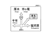
さらに、車両が経路33を進み、D地点に差し掛かると、図16に示す案内標識B021-1が見えてくる。このとき、経路33から特定される第一の進路は左折である。また、案内標識B021-1の左折側の地名「厚木」および「東名」は、横浜とは異なるが神奈川県方面であり、直進側の地名「府中」および「稲城」と、右折側の地名「渋谷」は、東京都方面である。このため、ドライバーは、「厚木」方面が横浜に近いと判断する可能性が高いので、案内標識B021-1の地名「厚木」に対応する第二の進路は左折である。従って、第一の進路と第二の進路とは合致しており、分岐地点の案内出力は、通常の経路案内である第一の案内出力となる。この場合における第一の案内出力は、例えば「この先、左折です。」といった案内である。
車両がD地点で国道409号線から国道246号線に左折してE地点に差し掛かると、図17に示す案内標識B022-1が見えてくる。案内標識B022-1には、直進方向に「厚木」および目的地の「市ヶ尾」が表示されている。このとき、経路33から特定される第一の進路は直進、案内標識B022-1における目的地の住所に含まれる地名「市ヶ尾」に対応する第二の進路は直進である。従って、第一の進路と第二の進路とは合致しており、分岐地点の案内出力は、通常の経路案内である第一の案内出力となる。この場合における第一の案内出力は、例えば「この先、直進です。」といった案内である。
その後、車両が経路33を進み、F地点に差し掛かると、図18に示す案内標識B025-1が見えてくる。さらに車両が進むと、図19に示す案内標識B025-2が見えてくる。案内標識B025-1および案内標識B025-2には、直進方向に「厚木」および目的地の「市ヶ尾」が表示されている。このとき、経路33から特定される第一の進路は直進、案内標識B025-1および案内標識B025-2における目的地の住所に含まれる地名「市ヶ尾」に対応する第二の進路は直進である。従って、第一の進路と第二の進路とは合致しており、分岐地点の案内出力は、通常の経路案内である第一の案内出力となる。この場合における第一の案内出力は、例えば「この先、直進です。」といった案内である。その後、端末装置10は、同様に経路案内を行って、車両が市ヶ尾に到着すると、経路案内を終了する。
このように、情報処理装置100は、入力された目的地から経路と目的地の住所とを抽出する。また、情報処理装置100は、車両の現在位置に基づいて、車両が目的地に至るまでに通過する経路上の分岐地点についての案内標識を特定する。また、情報処理装置100は、案内標識記憶部122に分岐地点に対応付けた案内標識と案内標識に含まれる各進路に対応付けた地名とを記憶する。また、情報処理装置100は、案内標識記憶部122を参照して、分岐地点について経路から特定される第一の進路と、目的地の住所に含まれる地名と一致する案内標識に表示された地名に対応する第二の進路とが合致する場合に第一の案内出力を出力する。また、情報処理装置100は、案内標識記憶部122を参照して、分岐地点について経路から特定される第一の進路と、目的地の住所に含まれる地名と一致する案内標識に表示された地名に対応する第二の進路とが合致しない場合に第二の案内出力を出力する。また、情報処理装置100は、案内出力を出力する際に、第一の案内出力と、第二の案内出力とを異なる案内出力にする。その結果、案内標識と経路案内の矛盾による事故リスクを低減できる。
また、情報処理装置100では、第二の案内出力は、第二の進路よりも第一の進路を優先する旨の案内出力である。その結果、ドライバーの混乱を抑止できる。
また、情報処理装置100は、第二の案内出力とともに、注意喚起を促す音声および画面表示のうち、1つ以上を出力する。その結果、よりドライバーの混乱を抑止できる。
なお、上記実施例では、情報処理装置100において経路探索を行ったが、これに限定されない。例えば、経路探索を行う他の情報処理装置を監視し、他の情報処理装置で行った経路探索の結果である経路と目的地とを取得して、取得した経路と目的地とに基づいて、経路案内処理を行ってもよい。
また、上記実施例では、各分岐地点の案内出力を出発時に設定したが、これに限定されない。例えば、移動する現在位置に基づいて、現在位置に近づいてくる分岐地点の案内出力を、適宜設定して、情報処理装置100から端末装置10に送信するようにしてもよい。
また、上記実施例では、目的地である市ヶ尾が横浜市内の中心地から離れている場合を具体例として説明したが、これに限定されない。例えば、新しい道路が開通したことにより、経路と案内標識とが異なる場合や、案内標識が生活道路を通る進路であるが、生活道路を避ける場合等でも適用できる。
また、上記実施例では、経路案内処理を情報処理装置100で行って、経路と、各分岐地点の案内出力とを端末装置10に送信したが、これに限定されない。例えば、地図DB121および案内標識記憶部122を端末装置10内に設け、端末装置10において経路案内処理を行うようにしてもよい。
また、図示した各部の各構成要素は、必ずしも物理的に図示の如く構成されていることを要しない。すなわち、各部の分散・統合の具体的形態は図示のものに限られず、その全部または一部を、各種の負荷や使用状況等に応じて、任意の単位で機能的または物理的に分散・統合して構成することができる。例えば、特定部132と案内出力部133とを統合してもよい。また、図示した各処理は、上記の順番に限定されるものではなく、処理内容を矛盾させない範囲において、同時に実施してもよく、順序を入れ替えて実施してもよい。
さらに、各装置で行われる各種処理機能は、CPU(又はMPU、MCU(Micro Controller Unit)等のマイクロ・コンピュータ)上で、その全部または任意の一部を実行するようにしてもよい。また、各種処理機能は、CPU(またはMPU、MCU等のマイクロ・コンピュータ)で解析実行されるプログラム上、またはワイヤードロジックによるハードウェア上で、その全部または任意の一部を実行するようにしてもよいことは言うまでもない。
ところで、上記の実施例で説明した各種の処理は、予め用意されたプログラムをコンピュータで実行することで実現できる。そこで、以下では、上記の実施例と同様の機能を有するプログラムを実行するコンピュータの一例を説明する。図20は、経路案内プログラムを実行するコンピュータの一例を示す図である。
図20に示すように、コンピュータ200は、各種演算処理を実行するCPU201と、データ入力を受け付ける入力装置202と、モニタ203とを有する。また、コンピュータ200は、記憶媒体からプログラム等を読み取る媒体読取装置204と、各種装置と接続するためのインタフェース装置205と、他の情報処理装置等と有線または無線により接続するための通信装置206とを有する。また、コンピュータ200は、各種情報を一時記憶するRAM207と、ハードディスク装置208とを有する。また、各装置201~208は、バス209に接続される。
ハードディスク装置208には、図1に示した抽出部131、特定部132および案内出力部133の各処理部と同様の機能を有する経路案内プログラムが記憶される。また、ハードディスク装置208には、地図DB121、案内標識記憶部122、および、経路案内プログラムを実現するための各種データが記憶される。入力装置202は、例えば、図1に示した操作部112と同様の機能を有し、コンピュータ200の管理者から操作情報等の各種情報の入力を受け付ける。モニタ203は、例えば、コンピュータ200の管理者に対して表示画面等の各種画面を表示する。インタフェース装置205は、例えば印刷装置等が接続される。通信装置206は、例えば、図1に示した通信部110と同様の機能を有し端末装置10と接続され、端末装置10と各種情報をやりとりする。
CPU201は、ハードディスク装置208に記憶された各プログラムを読み出して、RAM207に展開して実行することで、各種の処理を行う。また、これらのプログラムは、コンピュータ200を図1に示した抽出部131、特定部132および案内出力部133として機能させることができる。
なお、上記の経路案内プログラムは、必ずしもハードディスク装置208に記憶されている必要はない。例えば、コンピュータ200が読み取り可能な記憶媒体に記憶されたプログラムを、コンピュータ200が読み出して実行するようにしてもよい。コンピュータ200が読み取り可能な記憶媒体は、例えば、CD-ROMやDVDディスク、USB(Universal Serial Bus)メモリ等の可搬型記録媒体、フラッシュメモリ等の半導体メモリ、ハードディスクドライブ等が対応する。また、公衆回線、インターネット、LAN等に接続された装置にこの経路案内プログラムを記憶させておき、コンピュータ200がこれらから経路案内プログラムを読み出して実行するようにしてもよい。
1 経路案内システム
10 端末装置
11 通信部
12 制御部
13 表示部
14 操作部
100 情報処理装置
110 通信部
111 表示部
112 操作部
120 記憶部
121 地図DB
122 案内標識記憶部
130 制御部
131 抽出部
132 特定部
133 案内出力部
N ネットワーク
10 端末装置
11 通信部
12 制御部
13 表示部
14 操作部
100 情報処理装置
110 通信部
111 表示部
112 操作部
120 記憶部
121 地図DB
122 案内標識記憶部
130 制御部
131 抽出部
132 特定部
133 案内出力部
N ネットワーク
Claims (5)
- 入力された目的地から経路と前記目的地の住所とを抽出し、
車両の現在位置に基づいて、車両が前記目的地に至るまでに通過する前記経路上の分岐地点についての案内標識を特定し、
前記分岐地点に対応付けた案内標識と前記案内標識に含まれる各進路に対応付けた地名とを記憶する記憶部を参照して、前記分岐地点について前記経路から特定される第一の進路と、前記目的地の住所に含まれる地名と一致する前記案内標識に表示された地名に対応する第二の進路とが合致する場合における第一の案内出力と、前記分岐地点について前記経路から特定される第一の進路と、前記目的地の住所に含まれる地名と一致する前記案内標識に表示された地名に対応する第二の進路とが合致しない場合における第二の案内出力とを異なる案内出力にする、
処理をコンピュータに実行させることを特徴とする経路案内プログラム。 - 前記第二の案内出力は、前記第二の進路よりも前記第一の進路を優先する旨の案内出力である、
ことを特徴とする請求項1に記載の経路案内プログラム。 - 前記異なる案内出力にする処理は、前記第二の案内出力とともに、注意喚起を促す音声および画面表示のうち、1つ以上を出力する、
ことを特徴とする請求項1に記載の経路案内プログラム。 - 入力された目的地から経路と前記目的地の住所とを抽出し、
車両の現在位置に基づいて、車両が前記目的地に至るまでに通過する前記経路上の分岐地点についての案内標識を特定し、
前記分岐地点に対応付けた案内標識と前記案内標識に含まれる各進路に対応付けた地名とを記憶する記憶部を参照して、前記分岐地点について前記経路から特定される第一の進路と、前記目的地の住所に含まれる地名と一致する前記案内標識に表示された地名に対応する第二の進路とが合致する場合における第一の案内出力と、前記分岐地点について前記経路から特定される第一の進路と、前記目的地の住所に含まれる地名と一致する前記案内標識に表示された地名に対応する第二の進路とが合致しない場合における第二の案内出力とを異なる案内出力にする、
処理をコンピュータが実行することを特徴とする経路案内方法。 - 入力された目的地から経路と前記目的地の住所とを抽出する抽出部と、
車両の現在位置に基づいて、車両が前記目的地に至るまでに通過する前記経路上の分岐地点についての案内標識を特定する特定部と、
前記分岐地点に対応付けた案内標識と前記案内標識に含まれる各進路に対応付けた地名とを記憶する記憶部を参照して、前記分岐地点について前記経路から特定される第一の進路と、前記目的地の住所に含まれる地名と一致する前記案内標識に表示された地名に対応する第二の進路とが合致する場合における第一の案内出力と、前記分岐地点について前記経路から特定される第一の進路と、前記目的地の住所に含まれる地名と一致する前記案内標識に表示された地名に対応する第二の進路とが合致しない場合における第二の案内出力とを異なる案内出力にする案内出力部と、
を有することを特徴とする情報処理装置。
Priority Applications (2)
| Application Number | Priority Date | Filing Date | Title |
|---|---|---|---|
| PCT/JP2016/073007 WO2018025385A1 (ja) | 2016-08-04 | 2016-08-04 | 経路案内プログラム、経路案内方法および情報処理装置 |
| JP2018531697A JPWO2018025385A1 (ja) | 2016-08-04 | 2016-08-04 | 経路案内プログラム、経路案内方法および情報処理装置 |
Applications Claiming Priority (1)
| Application Number | Priority Date | Filing Date | Title |
|---|---|---|---|
| PCT/JP2016/073007 WO2018025385A1 (ja) | 2016-08-04 | 2016-08-04 | 経路案内プログラム、経路案内方法および情報処理装置 |
Publications (1)
| Publication Number | Publication Date |
|---|---|
| WO2018025385A1 true WO2018025385A1 (ja) | 2018-02-08 |
Family
ID=61072994
Family Applications (1)
| Application Number | Title | Priority Date | Filing Date |
|---|---|---|---|
| PCT/JP2016/073007 Ceased WO2018025385A1 (ja) | 2016-08-04 | 2016-08-04 | 経路案内プログラム、経路案内方法および情報処理装置 |
Country Status (2)
| Country | Link |
|---|---|
| JP (1) | JPWO2018025385A1 (ja) |
| WO (1) | WO2018025385A1 (ja) |
Citations (3)
| Publication number | Priority date | Publication date | Assignee | Title |
|---|---|---|---|---|
| JP2008070192A (ja) * | 2006-09-13 | 2008-03-27 | Denso Corp | 地名・退出方向対応関係報知装置および地名・退出方向対応関係報知装置用のプログラム |
| JP2009210431A (ja) * | 2008-03-04 | 2009-09-17 | Alpine Electronics Inc | ナビゲーションシステム |
| JP2011102732A (ja) * | 2009-11-10 | 2011-05-26 | Aisin Aw Co Ltd | ナビゲーションシステム |
-
2016
- 2016-08-04 WO PCT/JP2016/073007 patent/WO2018025385A1/ja not_active Ceased
- 2016-08-04 JP JP2018531697A patent/JPWO2018025385A1/ja active Pending
Patent Citations (3)
| Publication number | Priority date | Publication date | Assignee | Title |
|---|---|---|---|---|
| JP2008070192A (ja) * | 2006-09-13 | 2008-03-27 | Denso Corp | 地名・退出方向対応関係報知装置および地名・退出方向対応関係報知装置用のプログラム |
| JP2009210431A (ja) * | 2008-03-04 | 2009-09-17 | Alpine Electronics Inc | ナビゲーションシステム |
| JP2011102732A (ja) * | 2009-11-10 | 2011-05-26 | Aisin Aw Co Ltd | ナビゲーションシステム |
Also Published As
| Publication number | Publication date |
|---|---|
| JPWO2018025385A1 (ja) | 2019-03-28 |
Similar Documents
| Publication | Publication Date | Title |
|---|---|---|
| CN104236567B (zh) | 车载导航信息的获取方法及车载导航系统 | |
| US8798929B2 (en) | Navigation apparatus | |
| CN110431595B (zh) | 信息分析装置和路径信息分析方法 | |
| CN105393087B (zh) | 用于运行导航设备的方法、导航设备和机动车 | |
| JP7067429B2 (ja) | 情報処理装置、情報処理方法およびプログラム | |
| JPWO2012164601A1 (ja) | 移動体ナビゲーション装置及び移動体ナビゲーションシステム | |
| JP4670937B2 (ja) | ナビゲーション装置 | |
| CN110799806A (zh) | 用于动态车道引导的方法、装置和计算机程序产品 | |
| CN104471352A (zh) | 路径生成装置 | |
| JP6633372B2 (ja) | 経路探索装置及び経路探索方法 | |
| JP2020041907A (ja) | 経路誘導装置および経路誘導方法 | |
| JP2017032440A (ja) | 走行支援システム、走行支援方法及びコンピュータプログラム | |
| JP6184250B2 (ja) | 運転支援装置および運転支援方法 | |
| JP2011158304A (ja) | ナビゲーション装置およびネットワークデータのデータ構造 | |
| WO2010110050A1 (ja) | ナビサーバおよびナビシステム | |
| WO2018025385A1 (ja) | 経路案内プログラム、経路案内方法および情報処理装置 | |
| JP4622644B2 (ja) | 車載ナビゲーション装置 | |
| JP2016211884A (ja) | 案内装置、案内方法及び案内プログラム | |
| JP2019032573A (ja) | 運転支援装置、運転支援プログラム、運転支援方法および運転支援システム | |
| JP2018169914A (ja) | 情報分析装置及び情報分析方法 | |
| JP2010127770A (ja) | ナビゲーション装置及びナビゲーション方法 | |
| JP2017194317A (ja) | 情報表示装置および情報表示方法 | |
| JP6507690B2 (ja) | 運転支援システム、運転支援方法、運転支援プログラム | |
| US20160033296A1 (en) | Electronic map with directional rendering method and system | |
| JP6757224B2 (ja) | 案内装置、案内方法、及びプログラム |
Legal Events
| Date | Code | Title | Description |
|---|---|---|---|
| ENP | Entry into the national phase |
Ref document number: 2018531697 Country of ref document: JP Kind code of ref document: A |
|
| 121 | Ep: the epo has been informed by wipo that ep was designated in this application |
Ref document number: 16911644 Country of ref document: EP Kind code of ref document: A1 |
|
| NENP | Non-entry into the national phase |
Ref country code: DE |
|
| 122 | Ep: pct application non-entry in european phase |
Ref document number: 16911644 Country of ref document: EP Kind code of ref document: A1 |