WO2014192047A1 - 情報端末装置、および地図データ作成方法 - Google Patents
情報端末装置、および地図データ作成方法 Download PDFInfo
- Publication number
- WO2014192047A1 WO2014192047A1 PCT/JP2013/005465 JP2013005465W WO2014192047A1 WO 2014192047 A1 WO2014192047 A1 WO 2014192047A1 JP 2013005465 W JP2013005465 W JP 2013005465W WO 2014192047 A1 WO2014192047 A1 WO 2014192047A1
- Authority
- WO
- WIPO (PCT)
- Prior art keywords
- information
- attribute
- data
- map
- data list
- Prior art date
Links
Images


Classifications
-
- G—PHYSICS
- G01—MEASURING; TESTING
- G01C—MEASURING DISTANCES, LEVELS OR BEARINGS; SURVEYING; NAVIGATION; GYROSCOPIC INSTRUMENTS; PHOTOGRAMMETRY OR VIDEOGRAMMETRY
- G01C21/00—Navigation; Navigational instruments not provided for in groups G01C1/00 - G01C19/00
- G01C21/26—Navigation; Navigational instruments not provided for in groups G01C1/00 - G01C19/00 specially adapted for navigation in a road network
-
- G—PHYSICS
- G01—MEASURING; TESTING
- G01C—MEASURING DISTANCES, LEVELS OR BEARINGS; SURVEYING; NAVIGATION; GYROSCOPIC INSTRUMENTS; PHOTOGRAMMETRY OR VIDEOGRAMMETRY
- G01C21/00—Navigation; Navigational instruments not provided for in groups G01C1/00 - G01C19/00
- G01C21/38—Electronic maps specially adapted for navigation; Updating thereof
- G01C21/3804—Creation or updating of map data
- G01C21/3807—Creation or updating of map data characterised by the type of data
- G01C21/3815—Road data
- G01C21/3819—Road shape data, e.g. outline of a route
-
- G—PHYSICS
- G01—MEASURING; TESTING
- G01C—MEASURING DISTANCES, LEVELS OR BEARINGS; SURVEYING; NAVIGATION; GYROSCOPIC INSTRUMENTS; PHOTOGRAMMETRY OR VIDEOGRAMMETRY
- G01C21/00—Navigation; Navigational instruments not provided for in groups G01C1/00 - G01C19/00
- G01C21/38—Electronic maps specially adapted for navigation; Updating thereof
- G01C21/3863—Structures of map data
- G01C21/3867—Geometry of map features, e.g. shape points, polygons or for simplified maps
-
- G—PHYSICS
- G06—COMPUTING; CALCULATING OR COUNTING
- G06F—ELECTRIC DIGITAL DATA PROCESSING
- G06F16/00—Information retrieval; Database structures therefor; File system structures therefor
- G06F16/20—Information retrieval; Database structures therefor; File system structures therefor of structured data, e.g. relational data
- G06F16/29—Geographical information databases
-
- G—PHYSICS
- G09—EDUCATION; CRYPTOGRAPHY; DISPLAY; ADVERTISING; SEALS
- G09B—EDUCATIONAL OR DEMONSTRATION APPLIANCES; APPLIANCES FOR TEACHING, OR COMMUNICATING WITH, THE BLIND, DEAF OR MUTE; MODELS; PLANETARIA; GLOBES; MAPS; DIAGRAMS
- G09B29/00—Maps; Plans; Charts; Diagrams, e.g. route diagram
-
- G—PHYSICS
- G09—EDUCATION; CRYPTOGRAPHY; DISPLAY; ADVERTISING; SEALS
- G09B—EDUCATIONAL OR DEMONSTRATION APPLIANCES; APPLIANCES FOR TEACHING, OR COMMUNICATING WITH, THE BLIND, DEAF OR MUTE; MODELS; PLANETARIA; GLOBES; MAPS; DIAGRAMS
- G09B29/00—Maps; Plans; Charts; Diagrams, e.g. route diagram
- G09B29/003—Maps
-
- G—PHYSICS
- G09—EDUCATION; CRYPTOGRAPHY; DISPLAY; ADVERTISING; SEALS
- G09B—EDUCATIONAL OR DEMONSTRATION APPLIANCES; APPLIANCES FOR TEACHING, OR COMMUNICATING WITH, THE BLIND, DEAF OR MUTE; MODELS; PLANETARIA; GLOBES; MAPS; DIAGRAMS
- G09B29/00—Maps; Plans; Charts; Diagrams, e.g. route diagram
- G09B29/10—Map spot or coordinate position indicators; Map reading aids
- G09B29/106—Map spot or coordinate position indicators; Map reading aids using electronic means
Definitions
- the present invention relates to an information terminal device capable of displaying a map and a map data creation method for creating map data stored in the information terminal device.
- map data used for displaying a map in an information terminal device holds information related to map components and attribute information representing the attributes of these components.
- map data structure it is necessary to associate data related to map components with corresponding attribute data by some means.
- An information terminal device capable of flexibly adding and deleting attribute values, a map data creation method used therefor, and map data It is to provide a recorded map data recording medium.
- the information terminal device includes a feature information data list in which feature information indicating features is arranged, an attribute information data list in which attribute information of features is arranged in accordance with the order of the feature information, A map database unit for storing map data having a related information data list in which related information for associating the object information with the attribute information is arranged corresponding to the order of the feature information; a navigation function executing unit for executing a navigation function; A data access unit that acquires map data used for the navigation function execution unit from the map database unit.
- a map data creation method is a map data creation method executed by a map data creation device, the step of creating a feature information data list in which feature information indicating features is arranged, A step of creating an attribute information data list in which attribute information of an object is arranged corresponding to the order of the feature information, and a relation in which related information for associating the feature information with the attribute information is arranged in accordance with the order of the feature information Creating an information data list.
- the information terminal device improves the data expandability when adding or deleting attribute values of attribute information.
- the data expandability when adding or deleting attribute values of attribute information is improved.
- FIG. 1 schematically shows the structure of map data in Embodiment 1 of the present invention.
- the map database unit 8 provided in the information terminal device records the feature information 9 and the attribute information 72 as information relating to the components of the map.
- the feature information 9 includes at least one of geometric information 70 indicating coordinates including latitude and longitude indicating the shape of the feature, and phase information 73 indicating connection between the features.
- FIG. 1 shows a case where the feature information 9 includes both geometric information 70 and phase information 73.
- a feature is defined as a concept indicating everything existing above and below the ground. For example, this includes roads, railways (including subways), rivers, buildings, administrative boundaries, and the like.
- the geometric information 70, the attribute information 72, and the phase information 73 are associated with each other.
- the phase information 73 and the attribute information 72 are associated with each other.
- the geometric information 70 and the attribute information 72 are associated with each other.
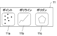
- FIG. 2 shows a geometric information type 11 representing the type of geometric information 70.
- the geometric information 70 includes point (point) data 11 a that represents representative points of city names and place names, and polyline (line) data 11 b that represents lines such as rivers, bus routes, and contour lines. Can be classified into polygon (surface) data 11c representing a closed space such as a house plan, a park, and a lake.
- the attribute information 72 corresponding to the geometric information 70 includes road types such as national roads, prefectural roads, municipal roads, road widths, road names, and the like.
- road types such as national roads, prefectural roads, municipal roads, road widths, road names, and the like.
- FIG. 3 shows an example of the structure of the geometric information 70 for a plurality of features.
- the geometric information type 11 of the geometric information 70 is the point data 11a.
- the geometric information 70 includes, in addition to an array of coordinate points (coordinate array) indicating the shape of the geometric information 70, a geometric information type (POINT in FIG. 3) indicating the type of geometric shape, and a ground indicating the arrangement order of the geometric information 70.
- An object ID may be included.
- the geometric information type 11 of the geometric information 70 is polyline (line) data 11b
- the geometric information type 11 is a polyline
- the coordinate array includes a plurality of coordinates.
- the geometric information 70 becomes information indicating the shape of the feature by specifying the geometric information type 11 and the coordinate arrangement.
- Such geometric information 70 is stored in a storage device (HDD: HARD DISK DRIVE) having a magnetic disk or the like.
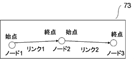
- FIG. 4 shows a schematic diagram for explaining the phase information 73 of the feature.
- the phase information 73 expresses the connection between features, and is expressed by nodes and links.
- the phase information 73 is necessary when managing network data such as a road network or a railway network.
- a node is a node that forms a network such as an intersection, and a link is a line segment that connects nodes.
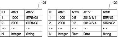
- FIG. 5 shows a configuration example of the attribute information 72 indicating the feature characteristics.
- the attribute information 72 includes an ID indicating the order of the attribute information and a plurality of types of attribute values (Attr_1, Attr_2 to Attr_n) indicating the features of the feature.
- Attr_1 is a numerical value (integer) indicating the width of the road and the like
- Attr_2 is a character string (string) indicating the name of the road and the like
- an image (image) such as an icon indicating a feature (not shown) Etc.
- a list in which attribute information 72 for a plurality of geometric information 70 is arranged becomes an attribute information data list 41.
- FIG. 6 shows the structure of the map data in the first embodiment of the present invention.
- the map data in the first embodiment of the present invention includes a geometric information data list 21 in which geometric information 70 is arranged, an attribute information data list 41 in which attribute information 72 is arranged, and a related information data list in which related information 71 for associating them is arranged. 43. That is, information that associates the geometric information 70 with the attribute information 72 is newly created, and the association between the geometric information 70 and the attribute information 72 is made efficient.
- the related information 71 is, for example, information created by a map data creation device in a factory or the like, and is information indicating which geometric information 70 has which attribute information 72. That is, since each piece of related information 71 is created corresponding to each piece of geometric information 70, the number of pieces of geometric information 70 in the piece of geometric information data list 21 and the number of pieces of related information 71 in the piece of related information data list 43 are the same.
- the geometric information 70 belongs to the feature information 9
- the geometric information data list 21 belongs to the feature information data list 10.
- the feature information 9 includes the phase information 73
- the phase information data list in which the phase information 73 is arranged also becomes the feature information data list 10. That is, the feature information data list 10 includes at least one of the phase information data list and the geometric information data list 21.
- association between the geometric information 70 and the attribute information 72 will be described, but the association between the phase information 73 and the attribute information 72 can also be performed in the same manner, and thus the description thereof is omitted.
- phase information data list in which the phase information 73 is arranged and the attribute information data list 41 are associated as the feature data list 10, association is performed by creating the related information described below. Is possible.
- the order of the attribute information 72 in the attribute information data list 41 is arranged in an order corresponding to the geometric information 70 in the geometric information data list 21.
- the order of arrangement of the related information 71 in the related information data list 43 is arranged in an order corresponding to the geometric information 70 in the geometric information data list 21.
- the geometric information 70 is associated with the related information 71 without having a special flag. That is, the arrangement of the attribute information 72 in the attribute information data list 41 is basically in the same order as the arrangement of the related information 71 in the related information data list 43.
- the related information 71 includes information that the geometric information 70 does not have the attribute information 72. This is a case where, for example, the geometric information 70 for a certain road exists but the attribute information 72 related to the geometric information 70 is missing or unknown. That is, this is a case where all the rows corresponding to the ID with the attribute information 72 shown in FIG. 5 are missing.
- the related information (Relation_ 3) corresponding to the third in the related information data list 43 when the geometric information (Geometry_ 3) corresponding to the third in the geometric information data list 21 does not have the attribute information 72, the related information (Relation_ 3) corresponding to the third in the related information data list 43.
- the geometric information (Geometry_3) includes information indicating that the corresponding attribute information 72 is not included.
- the attribute information 72 corresponding to the geometric information 70 can be omitted, and the attribute information 72 can be arranged and arranged in the attribute information data list 41.
- the data size of the attribute information data list 41 can be kept small.
- the geometric information 70 has the attribute information 72 or not, the geometric information 70 is not included in the related information 71, and therefore the attribute information 72 is changed or added. However, it is not necessary to change the geometric information 70 itself, and high expandability can be ensured.
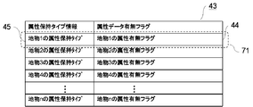
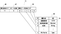
- FIG. 7 shows in detail the related information 71 in the related information data list 43.
- the related information 71 includes an attribute data presence / absence flag 44 and attribute holding type information 45.
- the attribute data presence / absence flag 44 indicates what kind of attribute the geometric information 70 has.
- the attribute holding type information 45 is information indicating an attribute holding mode of the geometric information 70.
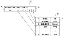
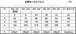
- FIG. 8 shows the attribute data presence flag 44 and the attribute holding type information 45 in the related information 71 in more detail.
- the attribute data presence / absence flag 44 has an array of 1-bit Boolean values (0 or 1), each corresponding to various attribute values (attribute types). This array of attribute values is predefined by the attribute definition information data list 42 shown in FIG.
- the array of Boolean values in the attribute data presence / absence flag 44 is an array corresponding to the attribute definition information 74 in the attribute definition information data list 42.
- the attribute definition information data list 42 is created in advance by a map data creator or the like, and is input to the map data creation device when the map data is created.
- the attribute definition information data list 42 includes attribute definition information 74 in which various attribute values are defined, and defines an ID, an attribute name, and a type indicating an array of the attribute definition information 74.
- the attribute definition information 74 is extracted from the attribute information 72 of the map source data by the map data creation device when the map source data is input to the map data creation device.
- the attribute name of the attribute information 72 includes a road type, parking presence / absence, name, an arbitrary attribute name, AttrName, and the like. Int16 (value representing the road type), Boolean (0 or 1) ), String (name of road), and type Type corresponding to an arbitrary attribute name are arranged.
- the attribute definition information data list 42 is stored in a storage device having a magnetic disk or the like using data definition means such as XML, and is used for map display or the like in the information terminal device. *
- the attribute holding type information 45 is 2-bit data located at the head of the related information 71. Further, since the attribute holding type information 45 uses 2-bit data, it is possible to express a four-pattern data configuration.
- the bit value of the attribute holding type information 45 is “00”, it indicates that the corresponding geometric information 70 does not hold the attribute information 72.
- the related information 71 does not have the attribute data presence / absence flag 44 but has only the data (2 bits) of the attribute holding type information 45.
- the data size of the related information data list 43 can be kept small.
- an attribute data presence / absence flag 44 is arranged after 2 bits of the attribute holding type information 45 as shown in FIG.
- the array of Boolean values constituting the attribute data presence / absence flag 44 corresponds to the order of the attribute definition information 74 defined in the attribute definition information data list 42 in advance. Note that this arrangement may be in the ascending order as long as the data arrangement order is the same.
- the data presence / absence flag 44 has presence / absence of attribute definition information 74 (AttrName) defined in the attribute definition information data list 42 (attribute data corresponding to the nth in FIG. 8). Since the presence / absence flag 44 is “0”, a 1-bit Boolean value indicating “no data” is stored. By adopting such an array, it is not necessary to provide a flag indicating which attribute definition information 74 corresponds to the Boolean value in the attribute data presence / absence flag 44, so that the data size can be reduced.
- the geometric information 70 corresponding to the related information 71 has attribute information 72 and further indicates that it has a plurality of groups.
- a group refers to various functions executed by the information terminal device, that is, applications. For example, a route search function and a map display function correspond to this.
- FIG. 9 shows the data structure of the related information 71 when the bit value of the attribute holding type information 45 is “10”.
- numerical data 46 indicating the number of groups is arranged between the attribute holding type information 45 and the attribute data presence / absence flag 44.
- the number of groups is “2”.
- the number of groups can be set in advance, for example, when creating map data.
- an array of Boolean values corresponding to the attribute data presence / absence flags 44 corresponding to the number of groups is arranged.
- the array of Boolean values in the attribute data presence / absence flag 44 for each group is the same as the arrangement of the attribute definition information 74 in the attribute definition information data list 42 as in the case where the value of the attribute holding type information 45 is “01”. It is.
- the geometric information 70 corresponding to the related information 71 has attribute information 72, and the geometric information 70 corresponding to the related information 71 is the same attribute definition information.
- 74 has a plurality of values.
- traffic regulation is changed in a time zone. For example, at an intersection, a right turn is allowed at a certain time zone, but a right turn is not possible at other times.
- FIG. 10 shows the data structure of the related information 71 when the bit value of the attribute holding type information 45 is “11”.
- a repeat count 47 indicating how many times the geometric information 70 repeats referring to the attribute information 72 is stored.
- the repeat count 47 is “3”.
- the repeat count 47 can be set in advance by using map data to be used, for example, when creating map data.
- an array of Boolean values of the attribute data presence / absence flag 44 is arranged. As described above, this arrangement order is the same as the arrangement of the attribute definition information 74 in the attribute definition information data list 42 defined in advance.
- the attribute information data list 41 is referred to a plurality of times, a plurality of corresponding attribute values are acquired, and only the attribute information 72 suitable for the time at which the attribute is acquired.
- the information terminal device only needs to execute a program that displays the image on the map.
- the attribute definition information 42 for each different time zone is created, and the attribute information 72 is referred to based on the attribute definition information 42 in all time zones. After that, the attribute data of the required time zone may be reflected.
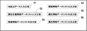
- FIG. 11 shows the steps of the map data creation method.
- the map data used by the information terminal device is created in advance by a map data creation device such as a factory, but the creation location of the map data is not limited.
- a map original data input step 51 inputs map original data including geometric information 70 and attribute information 72 to the map data creation device, arranges the geometric information 70, and displays the geometric information data list 21. It is a process to create. However, the arrangement of the geometric information 70 in the geometric information data list 21 may be arbitrary, and may be appropriately adjusted based on the attribute type of the feature.
- the attribute definition information data list input step 52 is a step of inputting the attribute definition information data list 42 created in advance by a product manufacturer or the like to the map data creation device.
- the related information data list creation step 53 refers to the attribute information 72 extracted by extracting attribute information 72 corresponding to the geometric information 70 based on the geometric information data list 21 already created in the map source data input step 51. On the other hand, this is a step of creating the related information data list 43 that associates the geometric information 70 with the attribute information 72.
- the related information data list output step 54 is a step of outputting the related information data list created in the related information data list creation step 53 to a storage device such as a magnetic disk.
- the attribute information data list creation step 55 extracts attribute information 72 included in the map source data input in the map data input step 51, and attributes based on the arrangement of the geometric information 70 of the geometric information data list 21 included in the map source data. This is a step of arranging the information 72 and creating the attribute information data list 41.
- the attribute information data list output step 56 is a step of outputting the attribute information data list 41 created in the attribute information data list creation step 55 to a storage device such as a magnetic disk.
- the steps 51 to 56 of the map data creation method described above are performed in ascending order of the numbers assigned thereto, the order in which these steps are performed is not limited to this.
- the related information data list Even if the creation process 53 and the related information data list output process 54 are replaced with the attribute information data list creation process 55 and the attribute information data list output process 56, the features of the present invention are not changed.
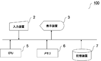
- FIG. 12 shows the configuration of the map data creation device 100 that executes each step of the map data creation method shown in FIG.
- a map data creation program for executing the steps 51 to 56 of the map data creation method is stored in the storage device 7 composed of a magnetic disk or the like, and is expanded in the memory 6 when used.
- map original data and the map data having the data structure according to the present invention created by each process are also stored in the storage device 7.
- the storage device 7 shown in FIG. 12 may be composed of a plurality of units depending on the data capacity.
- the user inputs an execution processing command to the map data creation device 100 with the input device 2 including a keyboard and a mouse in order to execute the map data creation program by the map data creation device.
- the execution process progress and execution result of the map data creation program can be confirmed from the display device 3.
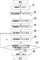
- FIG. 13 shows a map data creation procedure executed by the map data creation device 100.
- step S1 in order to create the map data according to the present invention, the map original data including the geometric information 70 and the attribute information 72 stored in the external storage device or the like is read and the geometric information 70 is arranged. A list 21 is created.
- step S2 the attribute definition information data list 42 created in advance is input.
- step S3 the related information data list 43 as shown in FIGS. 7 to 10 is created.
- step S4 shown in FIG. 13 the information is output to the storage device 7 including the related information data list 43 created in step S3 and a magnetic disk.
- step S5 the attribute information data list 41 as shown in FIG. 6 is created using the related information data list 43 created in step S3 and the map source data inputted in step S1.
- step S6 the attribute information data list 41 created in step S5 is output to an external storage device such as a magnetic disk.
- step S7 it is determined whether or not the output of the attribute information data list 41 corresponding to the related information data list 43 created in step S3 is completed, and the attribute information data in which attribute information 72 corresponding to all the geometric information 70 is arranged. If the output of the list 41 has been completed, the creation of the map data is completed. If the output has not been completed, the process returns to step S5 to create the attribute information data list 41.
- map data creation procedures S1 to S8 described above are performed in ascending order of step numbers, the order in which the procedures are executed is not limited to this.
- the related information data list creation step S3, the related information output step S4, the attribute information data list creation step S5, and the attribute information data list output step S6 may be replaced.
- the related information data list 43 differs depending on the application using the map data.
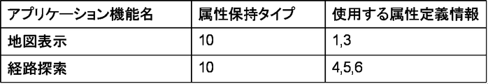
- FIG. 14 shows a difference in attribute definition information 74 used in an application when creating map data.
- the attribute definition information 74 to be used is the first (ID: 1, attribute name: road type, type: Int16) and the third (ID: 3, attribute name) in the attribute definition information data list 42. : Name, type: String).
- the attribute definition information 74 used is the fourth, fifth, and sixth (both not shown) of the attribute definition information data list 42.
- FIG. 15 is a block diagram showing an example of a hardware configuration of the information terminal device 1 according to the present invention.
- a mobile information terminal such as a car navigation device (vehicle information terminal device), a smartphone, a mobile phone, or a PDA (PERSONAL DIGITAL ASSISANT) is assumed.
- the storage device 17 includes map data created by the present invention, a data access program for accessing the map data, an application program for executing a desired function using the map data, data used in application processing, and the like. It is remembered.
- the data access program is a program for acquiring data necessary for executing the application program from a set of data stored in the storage device 17.
- the application program is a program for realizing various functions executed by the information terminal device 1, for example, a program for realizing a route guidance function, a map display function, and a route search function in the car navigation device.
- the data access program and the application program are expanded from the storage device 17 onto the memory 16 and executed by the CPU 15.
- the storage device 17 includes a hard disk device (HDD) mounted on the information terminal device 1, an external storage medium such as a CD or DVD that can be played back by a drive device mounted on the information terminal device 1, and a predetermined input / output interface. It is possible to use a recording medium such as a USB (UNIVERSAL SERIAL BUS) memory capable of reading and writing data via the.
- HDD hard disk device
- an external storage medium such as a CD or DVD that can be played back by a drive device mounted on the information terminal device 1
- a predetermined input / output interface It is possible to use a recording medium such as a USB (UNIVERSAL SERIAL BUS) memory capable of reading and writing data via the.
- the calculation result by the CPU 15 is output to the display device 13 via the bus 18 and displayed on the screen.
- the display device 13 is a device that can display, for example, a map used for route guidance, and is realized by a liquid crystal display, a plasma display, or the like.
- the communication device 14 is a device that communicates with an external device (not shown).
- the communication device 14 detects position information by receiving at least one of a GPS signal and an FM radio wave from a GPS (GLOBAL POSITIONING SYSTEM) satellite. Functions as a position detection unit.
- a GPS GLOBAL POSITIONING SYSTEM
- the input device 12 is a device from which a user performs operation input from the outside, and corresponds to a keyboard, operation switches, a touch panel combined with the display device 13, and the like.
- the user inputs conditions for route search, map display, or the like, or selects an application using the input device 12.
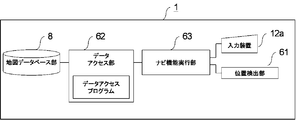
- FIG. 16 specifically shows a configuration for the information terminal device 1 according to Embodiment 1 of the present invention to perform map display from map data created by the map creation method according to the present invention.
- an in-vehicle information terminal device is particularly shown as an example of the information terminal device 1.
- the information terminal device 1 has an input device 12a having a display function in which the input device 12 and the display device 13 shown in FIG.
- the input device 12a includes a keyboard, operation switches, or a display device having a touch panel.
- the position detector 61 has a function of detecting position information by receiving at least one of a GPS signal and an FM radio wave from a GPS satellite. This corresponds to the communication device 14 shown in FIG.
- the map database unit 8 is a component that stores map data created by the method according to the present invention, and is stored in the storage device 17 in FIG.
- the navigation function execution unit 63 performs navigation such as map display based on the map data acquired from the map database unit 8 via the data access unit 62 and the current position of the information terminal device 1 detected by the position detection unit 61. It is a component that performs various necessary functions.
- the navigation function execution unit 63 includes the CPU 15, the memory 16, and the storage device 17 in FIG.
- the data access unit 62 is a component interposed between the navigation function execution unit 63 and the map database unit 8 so that the navigation function execution unit 63 appropriately acquires map data.
- the data access unit 62 is also configured by the CPU 15, the memory 16, and the storage device 17 in FIG.
- the feature information data list 10 in which the feature information 9 indicating the feature is arranged and the attribute information 72 of the feature correspond to the order of the feature information 9.
- the feature information data list 10 indicates the connection between the feature and the geometric information data list 21 in which the geometric information 70 indicating the shape of the feature is arranged. Since at least one of the phase information data lists in which the phase information 73 is arranged is included, the attribute value of the attribute information 72 is added or deleted when the geometric information 70 and the attribute information 72 or the phase information 73 and the attribute information 72 are associated with each other. Data extensibility is improved.
- the related information 71 further includes the attribute holding type information 45 indicating the holding type of the attribute information 72, so even if it is desired to acquire a plurality of attributes at once, data Access efficiency is improved.
- the map data stored in the map database unit 8 is attribute definition information data in which attribute definition information 74 defining the attribute type of the attribute information 72 is arranged.
- the related information 71 includes an attribute data presence / absence flag 44 indicating whether or not the attribute definition information 74 referred to by the related information 71 exists. Attribute information 72 can be selected according to the machine and the low-priced machine, and the map data can be customized.
- the attribute data presence / absence flag 44 is arranged corresponding to the order of the attribute definition information 74 in the attribute definition information data list 42. Since the acquisition is efficient and specific ID information is not required, the data size of the map data can be reduced.
- the map data creation method is a map data creation method executed by the map data creation device, and creates a feature information data list 10 in which feature information 9 indicating features is arranged.
- the feature information data list 10 includes the geometric information data list 21 in which the geometric information 70 indicating the shape of the feature is arranged and the phase indicating the connection between the features. Since at least one of the phase information data lists in which the information 73 is arranged is included, the attribute value of the attribute information 72 is added or deleted when the geometric information 70 and the attribute information 72 or the phase information 73 and the attribute information 72 are associated with each other. Data extensibility is improved.
- the related information 71 further includes attribute holding type information 45 indicating the holding type of the attribute information 72. Therefore, even when a plurality of attributes are desired to be acquired at once, data access is performed. Increases efficiency.
- the map data creation method executed by the map data creation device creates the attribute definition information data list 42 in which the attribute definition information 74 that defines the attribute type of the attribute information 72 is arranged.
- the related information 71 includes an attribute data presence / absence flag 44 indicating whether or not the attribute definition information 74 referred to by the related information 71 exists.
- the attribute information 72 can be selected according to the low-priced machine, and the map data can be customized.
- the attribute data presence / absence flag 44 is arranged corresponding to the order of the attribute definition information 74 in the attribute definition information data list 42. Since the acquisition is efficient and specific ID information is not required, the data size of the map data can be reduced.
- the map data recording medium is a recording medium that records a data list constituting map data, and includes a feature information data list 10 in which feature information 9 indicating features is arranged, The attribute information data list 72 in which the attribute information 72 of the object is arranged corresponding to the order of the feature information 9, and the related information 71 that associates the feature information 9 and the attribute information 72 are associated with the order of the feature information 9. Since the arrayed related information data list 43 is recorded, the data expandability when the attribute value of the attribute information 72 is added or deleted is improved.
- the feature information data list 10 shows the connection between the feature and the geometric information data list 21 in which the geometric information 70 indicating the shape of the feature is arranged. Since at least one of the phase information data lists in which the phase information 73 is arranged is included, the attribute value of the attribute information 72 is added or deleted when the geometric information 70 and the attribute information 72 or the phase information 73 and the attribute information 72 are associated with each other. Data extensibility is improved.
- the related information 71 further includes the attribute holding type information 45 indicating the holding type of the attribute information 72, so that even if it is desired to acquire a plurality of attributes at once, data Access efficiency is improved.
- the map data recording medium in which the data list constituting the map data is recorded further includes the attribute definition information data list 42 in which the attribute definition information 74 defining the attribute type of the attribute information 72 is arranged.
- the related information 71 recorded and has the attribute data presence / absence flag 44 indicating whether or not the attribute definition information 74 referred to by the related information 71 exists. ),
- the attribute information 72 can be selected, and the map data can be customized.
- the attribute data presence / absence flag 44 is arranged corresponding to the order of the attribute definition information 74 in the attribute definition information data list 42. Since the acquisition is efficient and specific ID information is not required, the data size of the map data can be reduced.
- Embodiment 2 FIG. In the second embodiment of the present invention, as shown in FIG. 17, a plurality of attribute information data lists 72 obtained by extracting only the attribute information 72 used by the application are created, and the created attribute information data lists 72 are created for each application. It is managed as a function list. As described in the first embodiment, the attribute definition information 72 to be referenced differs depending on the application.
- the first application is managed by the first attribute information data list 101
- the second application is the second attribute information data.
- Managed by the list 102 In this case, an attribute definition information data list 42 corresponding to each attribute information data list 41 may be further created, and a related information data list 43 corresponding thereto may be separately created and managed.
- the map data stored in the map database unit 8 has a plurality of attribute information data lists 41 and the related information data list 43 corresponding to the attribute information data list 41. Since there are a plurality of applications, the application can collectively acquire attribute information 72 for realizing necessary functions, and an improvement in the processing speed of the application can be expected.
- the map data stored in the map database unit 8 has a plurality of attribute information data lists 41, and the related information data list corresponding to the attribute information data list 41. Therefore, the application does not need to extract attributes to be used after acquiring all the attribute information 72 included in the attribute information data list 41 or acquire only the attributes to be used from the attribute information data list 41 in advance. Since a processing load is generated, the efficiency of accessing the attribute information 72 can be improved.
- the map data stored in the map database unit 8 has a plurality of attribute information data lists 41, and the related information data list corresponding to the attribute information data list 41. Since there are a plurality of 43, the application can collectively acquire the attribute information 72 for realizing a necessary function, and an improvement in the processing speed of the application can be expected.
- the map data stored in the map database unit 8 has a plurality of attribute information data lists 41, and the related information data list corresponding to the attribute information data list 41. 43, the application does not need to extract the attributes to be used after acquiring all the attribute information 72 included in the attribute information data list 41, or to acquire only the attributes to be used in advance from the attribute information data list 41. Since a processing load is generated, the efficiency of accessing the attribute information 72 can be improved.
- the map data recording medium on which the data list constituting the map data is recorded records a plurality of attribute information data lists 41 and further records a related information data list 43 corresponding to the attribute information data list 41. Therefore, the application can collectively acquire the attribute information 72 for realizing a necessary function, and an improvement in the processing speed of the application can be expected.
- the map data recording medium on which the data list constituting the map data is recorded records a plurality of attribute information data lists 41 and further records a related information data list 43 corresponding to the attribute information data list 41. Therefore, the application does not need to extract the attribute to be used after acquiring all the attribute information 72 included in the attribute information data list 41, or to acquire only the attribute to be used in advance from the attribute information data list 41. Since a processing load occurs, the efficiency of accessing the attribute information 72 can be improved.
- Embodiment 3 In the third embodiment of the present invention, as shown in FIG. 18, a method of storing the attribute information 72 to be referred to by the attribute data presence / absence flag in the related information by an address is adopted.
- an address of the attribute information 72 to be referred to by the related information an offset, an index, and the like of the attribute definition information 74 corresponding to the desired attribute information in the attribute definition information data list 42 are prepared in advance and stored as the address information 110. At this time, the address information 110 is referred to.
- the attribute information 72 is referred to based on the Boolean value arranged in the attribute data presence / absence flag 44.
- the attribute data presence / absence flag 44 is referred to. Referenced all the Boolean values arranged in
- Embodiment 3 since only the Boolean value corresponding to the attribute information 72 to be referred to in the attribute definition information data list 42 is referred to, the association can be performed at high speed. Further, since all the attribute information 72 included in the map original data is retained without being omitted, the attribute definition information data list 42 including only the attribute information 72 to be used is further added as shown in the second embodiment. There is no need to create it.
- such address information 110 is created by, for example, a map data creation device and stored in the storage device 17 shown in FIG.
- the map data stored in the map database unit 8 includes the attribute definition information data list 42 in which the attribute definition information 74 that defines the attribute type of the attribute information 72 is arranged.
- the related information 71 refers to the attribute definition information 74 referred to by the related information 71 by the address information 110 in the attribute definition information data list 42 in which the attribute definition information 74 is stored.
- the map data creation method executed by the map data creation device further includes an attribute definition information data list 42 in which attribute definition information 74 defining the attribute type of the attribute information 72 is arranged.
- the related information 71 refers to the attribute definition information 74 referred to by the related information 71 by the address information 110 in the attribute definition information data list 42 in which the attribute definition information 74 is stored.
- the map data recording medium in which the data list constituting the map data is recorded further includes the attribute definition information data list 42 in which the attribute definition information 74 defining the attribute type of the attribute information 72 is arranged.
- the related information 71 is recorded and the attribute definition information 74 referred to by the related information 71 is referred to by the address information 110 in the attribute definition information data list 42 in which the attribute definition information 74 is stored.
- the address information 110 is referred to, so that the application need not expand the data while sequentially scanning the data stored in the attribute information 72. Because it is possible to directly access to, it can be expected to improve the accessibility to the desired map data
- Embodiment 4 FIG.
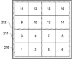
- the map area reflected by the map data on the map display is divided into rectangular areas and managed as shown in FIG.
- the solid line indicates the level 210 mesh 210
- the dotted line indicates the level 2 mesh 211
- the double line indicates the level 3 mesh 212.
- the level 2 mesh 211 is composed of a region obtained by combining four level 1 meshes 210
- the level 3 mesh 212 is composed of a region obtained by combining four level 2 meshes 211. That is, level 3 consists of 16 meshes of level 1.
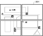
- FIG. 20 shows a map 201 managed by a level 1 mesh 210.
- a map created by the map data is divided and managed as a map 201. This mesh structure is the same even if the level increases.
- FIG. 21 shows a form in which map data is managed hierarchically according to the data detail level of the map data.
- FIG. 21 exemplifies map data of three layers.
- the mesh 210 indicated by the solid line is used when the map is enlarged (large scale) and displayed, and the mesh 211 indicated by the dotted line is used when the map is displayed at a smaller scale than the mesh 210.
- the mesh 212 shown is used when displaying at a smaller scale than the mesh 211.
- the number of pieces of geometric information 70 to be displayed varies depending on the enlarged / reduced display of the map. For example, when displaying a map at a small scale, it is not necessary to associate the attribute information 72 corresponding to all the geometric information 70 in the displayed range. Conversely, when displaying a map at a large scale, it is necessary to associate a lot of geometric information 70 with the attribute information 72. Thus, since the number of pieces of geometric information 70 necessary for display varies depending on the scale in the mesh to be displayed, the related information data list 43 is created for each mesh.
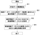
- FIG. 22 shows the flow of processing for acquiring map data relating to a desired range by the data access program in the data access unit 62 from the map database unit 8 described in FIG.
- a data range required for map display is set (desired data range setting). This data range is determined based on the information of the position detection unit 61 shown in FIG. 16 or data input to the input device 12. The determined data range is set in the data access unit 62.
- step S12 the geometric information data list 21 corresponding to the desired data range is specified from the map data stored in the map database unit 8 of the information terminal device 1 shown in FIG.
- the desired data range is set in advance in step S11.
- step S13 the related information data list 43 corresponding to the geometric information data list 21 included in the range specified in step S12 is acquired from the map database unit 8.
- step S14 the attribute information data list 41 corresponding to the related information data list 43 acquired in step S13 is acquired from the feature database unit 8.
- the data access unit 62 acquires the map data used for the navigation function execution unit 63 for each divided map area. Since it can be managed in a simple manner, it can be expected that the accessibility to the desired map data is improved.
- the present invention is not limited to the above-described embodiment, and within the scope of the invention, the embodiments can be freely combined, or the embodiments can be appropriately changed or omitted. Moreover, the apparatus which can apply the map data concerning this invention is not limited to what was described in embodiment.
Abstract
Description
図1は、本発明の実施の形態1における地図データの構成を概略的に示したものである。情報端末装置に備えられている地図データベース部8は、地図の構成要素に係る情報としての地物情報9および属性情報72を記録している。さらに、地物情報9は地物の形状を示す緯度・経度などからなる座標を示す幾何情報70と、地物同士のつながりを示す位相情報73のうち少なくとも一方を含む。図1は、地物情報9が幾何情報70と位相情報73の両方を含む場合について示したものである。
本発明における実施の形態2では、図17に示すようにアプリケーションが使用する属性情報72のみを抽出した属性情報データリスト72を複数作成し、作成された複数の属性情報データリスト72をアプリケーションごとの機能リストとして管理する形態を採っている。実施の形態1で述べた通り、参照する属性定義情報72はアプリケーションによって異なる。
本発明における実施の形態3では、図18に示すように、関連情報における属性データ有無フラグが参照すべき属性情報72をアドレスで記憶しておく方法を採っている。関連情報が参照すべき属性情報72のアドレスとして、属性定義情報データリスト42における所望の属性情報に該当する属性定義情報74のオフセット、インデックスなどを予め準備しアドレス情報110として記憶しておき、関連付けの際このアドレス情報110を参照する。
本発明における実施の形態4では、地図データが地図表示に反映する地図の領域を、図19に示すように矩形領域で分割して管理する形態を採っている。図19の実線がレベル1のメッシュ210、点線がレベル2のメッシュ211、二重線がレベル3のメッシュ212を示している。
8 地図データベース部
9 地物情報
10 地物情報データリスト
21 幾何情報データリスト
41 属性情報データリスト
42 属性定義情報データリスト
43 関連情報データリスト
45 属性保持タイプ情報
44属性データ有無フラグ
62 データアクセス部
63 ナビ機能実行部
70 幾何情報
71 関連情報
72 属性情報
73 位相情報
74 属性定義情報
110 アドレス情報
Claims (10)
- 地物を示す地物情報を配列した地物情報データリストと、前記地物の属性情報を前記地物情報の順序に対応して配列した属性情報データリストと、前記地物情報と前記属性情報とを関連付ける関連情報を前記地物情報の順序に対応して配列した関連情報データリストとを有した地図データを格納する地図データベース部と、
ナビゲーション機能を実行するナビ機能実行部と、
前記地図データベース部から、前記ナビ機能実行部に用いられる地図データを取得するデータアクセス部と
を備えたことを特徴とする情報端末装置。 - 地物情報データリストは、地物の形状を示す幾何情報を配列した幾何情報データリストと、前記地物同士の繋がりを示す位相情報を配列した位相情報データリストのうち少なくとも一方を有することを特徴とする請求項1に記載の情報端末装置。
- 地図データベース部に格納される地図データは、
属性情報データリストを複数有し、前記属性情報データリストに対応した関連情報データリストを複数有することを特徴とする請求項1または請求項2に記載の情報端末装置。 - 関連情報は、属性情報の保持タイプを示す属性保持タイプ情報をさらに有することを特徴とする請求項1ないし請求項3のいずれか1項に記載の情報端末装置。
- 地図データベース部に格納される地図データは、
属性情報の属性の型を定義する属性定義情報を配列した、属性定義情報データリストをさらに有し、
関連情報は、
前記関連情報が参照する前記属性定義情報が、存在するか否かを示す属性データ有無フラグを有したことを特徴とする請求項1ないし請求項4のいずれか1項に記載の情報端末装置。 - 属性データ有無フラグは、属性定義情報データリストの属性定義情報の順序に対応して配列されたことを特徴とする請求項5に記載の情報端末装置。
- 地図データベース部に格納される地図データは、
属性情報の属性の型を定義する属性定義情報を配列した、属性定義情報データリストをさらに有し、
関連情報は、
前記関連情報が参照する前記属性定義情報を、前記属性定義情報が格納されている属性定義情報データリストにおけるアドレス情報によって参照することを特徴とする請求項1ないし請求項4のいずれか1項に記載の情報端末装置。 - データアクセス部は、
ナビ機能実行部に用いられる地図データを、分割された地図領域ごとに取得することを特徴とする請求項1ないし請求項7のいずれか1項に記載の情報端末装置。 - 情報端末装置は、車載情報端末装置であることを特徴とする請求項1ないし請求項8のいずれか1項に記載の情報端末装置。
- 地図データ作成装置によって実行される地図データ作成方法であって、
地物を示す地物情報を配列した地物情報データリストを作成するステップと、
前記地物の属性情報を前記地物情報の順序に対応して配列した属性情報データリストを作成するステップと、
前記地物情報と前記属性情報とを関連付ける関連情報を前記地物情報の順序に対応して配列した関連情報データリストを作成するステップとを有したことを特徴とする地図データ作成方法。
Priority Applications (4)
| Application Number | Priority Date | Filing Date | Title |
|---|---|---|---|
| US14/894,014 US9933267B2 (en) | 2013-05-27 | 2013-09-17 | Navigation device and navigation method |
| CN201380076930.9A CN105247322B (zh) | 2013-05-27 | 2013-09-17 | 信息终端装置以及地图数据制作方法 |
| DE112013007116.9T DE112013007116T5 (de) | 2013-05-27 | 2013-09-17 | Informationsterminal-Vorrichtung und Verfahren zum Erzeugen von Kartendaten |
| JP2015519503A JP6120960B2 (ja) | 2013-05-27 | 2013-09-17 | 情報端末装置、および地図データ作成方法 |
Applications Claiming Priority (2)
| Application Number | Priority Date | Filing Date | Title |
|---|---|---|---|
| JP2013-111094 | 2013-05-27 | ||
| JP2013111094 | 2013-05-27 |
Publications (1)
| Publication Number | Publication Date |
|---|---|
| WO2014192047A1 true WO2014192047A1 (ja) | 2014-12-04 |
Family
ID=51988132
Family Applications (1)
| Application Number | Title | Priority Date | Filing Date |
|---|---|---|---|
| PCT/JP2013/005465 WO2014192047A1 (ja) | 2013-05-27 | 2013-09-17 | 情報端末装置、および地図データ作成方法 |
Country Status (5)
| Country | Link |
|---|---|
| US (1) | US9933267B2 (ja) |
| JP (1) | JP6120960B2 (ja) |
| CN (1) | CN105247322B (ja) |
| DE (1) | DE112013007116T5 (ja) |
| WO (1) | WO2014192047A1 (ja) |
Families Citing this family (1)
| Publication number | Priority date | Publication date | Assignee | Title |
|---|---|---|---|---|
| DE102016217653A1 (de) | 2016-09-15 | 2018-03-15 | Bayerische Motoren Werke Aktiengesellschaft | Verfahren und Datenverarbeitungsanlage zur Erzeugung von Kartendaten einer digitalen Karte |
Citations (8)
| Publication number | Priority date | Publication date | Assignee | Title |
|---|---|---|---|---|
| JPH06274102A (ja) * | 1993-03-23 | 1994-09-30 | Nippon Telegr & Teleph Corp <Ntt> | 地図設備図面情報管理処理方法 |
| JP2001092352A (ja) * | 1999-09-20 | 2001-04-06 | Hitachi Information Systems Ltd | 地理情報システム及びそのプログラム記録媒体 |
| JP2002123835A (ja) * | 2000-10-16 | 2002-04-26 | Ntt Communications Kk | デジタル空間データの地物管理装置 |
| JP2005265491A (ja) * | 2004-03-17 | 2005-09-29 | Zenrin Co Ltd | 道路ネットワークデータのデータ構造 |
| JP2007101580A (ja) * | 2005-09-30 | 2007-04-19 | Aisin Aw Co Ltd | 地図データベース生成システム |
| JP2009009182A (ja) * | 2007-06-26 | 2009-01-15 | Pioneer Electronic Corp | 地物画像データ表示装置及び地物画像データ表示プログラム |
| JP2012173384A (ja) * | 2011-02-18 | 2012-09-10 | Aisin Aw Co Ltd | ナビゲーションシステム、ナビゲーション方法、及びナビゲーションプログラム |
| JP2012207973A (ja) * | 2011-03-29 | 2012-10-25 | Zenrin Co Ltd | 案内情報提供システム |
Family Cites Families (17)
| Publication number | Priority date | Publication date | Assignee | Title |
|---|---|---|---|---|
| US6161071A (en) * | 1999-03-12 | 2000-12-12 | Navigation Technologies Corporation | Method and system for an in-vehicle computing architecture |
| JP2002015215A (ja) * | 2000-06-30 | 2002-01-18 | Hitachi Ltd | マルチメデア情報配信システムおよび携帯情報端末装置 |
| JP4193392B2 (ja) | 2001-11-22 | 2008-12-10 | 三菱電機株式会社 | 地図情報処理装置及び地図情報更新システム |
| US7840032B2 (en) * | 2005-10-04 | 2010-11-23 | Microsoft Corporation | Street-side maps and paths |
| JP5183029B2 (ja) * | 2006-03-10 | 2013-04-17 | 日立オートモティブシステムズ株式会社 | 地図更新プログラム及び地図更新端末 |
| ATE462956T1 (de) * | 2006-03-31 | 2010-04-15 | Research In Motion Ltd | Verfahren zur kontrolle von kartenversionen und vorrichtung zur aktualisierung der verwendung von über ein netzwerk gewarteten kartendatensätzen für mobile kommunikationsvorrichtungen |
| WO2008050516A1 (fr) * | 2006-10-18 | 2008-05-02 | Mitsubishi Electric Corporation | Dispositif de traitement d'informations cartographiques |
| JP5305598B2 (ja) * | 2007-02-13 | 2013-10-02 | アイシン・エィ・ダブリュ株式会社 | ナビゲーション装置 |
| JP4725535B2 (ja) * | 2007-02-27 | 2011-07-13 | アイシン・エィ・ダブリュ株式会社 | 地図情報更新システム |
| JP5075443B2 (ja) * | 2007-03-27 | 2012-11-21 | アイシン・エィ・ダブリュ株式会社 | 道路地図データ生成装置、ナビゲーション装置、及び道路地図データ生成プログラム |
| JP4437556B2 (ja) * | 2007-03-30 | 2010-03-24 | アイシン・エィ・ダブリュ株式会社 | 地物情報収集装置及び地物情報収集方法 |
| JP4844978B2 (ja) * | 2007-07-11 | 2011-12-28 | 本田技研工業株式会社 | ナビ装置およびナビシステム |
| TWI386626B (zh) * | 2008-07-07 | 2013-02-21 | Wistron Corp | 用於一導航系統中的圖資更新裝置及相關導航系統 |
| JP2011145159A (ja) * | 2010-01-14 | 2011-07-28 | Denso Corp | 道路学習装置 |
| JP5440217B2 (ja) | 2010-01-29 | 2014-03-12 | 株式会社デンソー | 地図データ及び電子機器 |
| US20110302214A1 (en) * | 2010-06-03 | 2011-12-08 | General Motors Llc | Method for updating a database |
| US9002545B2 (en) * | 2011-01-07 | 2015-04-07 | Wabtec Holding Corp. | Data improvement system and method |
-
2013
- 2013-09-17 DE DE112013007116.9T patent/DE112013007116T5/de active Pending
- 2013-09-17 WO PCT/JP2013/005465 patent/WO2014192047A1/ja active Application Filing
- 2013-09-17 JP JP2015519503A patent/JP6120960B2/ja active Active
- 2013-09-17 CN CN201380076930.9A patent/CN105247322B/zh active Active
- 2013-09-17 US US14/894,014 patent/US9933267B2/en active Active
Patent Citations (8)
| Publication number | Priority date | Publication date | Assignee | Title |
|---|---|---|---|---|
| JPH06274102A (ja) * | 1993-03-23 | 1994-09-30 | Nippon Telegr & Teleph Corp <Ntt> | 地図設備図面情報管理処理方法 |
| JP2001092352A (ja) * | 1999-09-20 | 2001-04-06 | Hitachi Information Systems Ltd | 地理情報システム及びそのプログラム記録媒体 |
| JP2002123835A (ja) * | 2000-10-16 | 2002-04-26 | Ntt Communications Kk | デジタル空間データの地物管理装置 |
| JP2005265491A (ja) * | 2004-03-17 | 2005-09-29 | Zenrin Co Ltd | 道路ネットワークデータのデータ構造 |
| JP2007101580A (ja) * | 2005-09-30 | 2007-04-19 | Aisin Aw Co Ltd | 地図データベース生成システム |
| JP2009009182A (ja) * | 2007-06-26 | 2009-01-15 | Pioneer Electronic Corp | 地物画像データ表示装置及び地物画像データ表示プログラム |
| JP2012173384A (ja) * | 2011-02-18 | 2012-09-10 | Aisin Aw Co Ltd | ナビゲーションシステム、ナビゲーション方法、及びナビゲーションプログラム |
| JP2012207973A (ja) * | 2011-03-29 | 2012-10-25 | Zenrin Co Ltd | 案内情報提供システム |
Also Published As
| Publication number | Publication date |
|---|---|
| CN105247322A (zh) | 2016-01-13 |
| JPWO2014192047A1 (ja) | 2017-02-23 |
| JP6120960B2 (ja) | 2017-04-26 |
| US9933267B2 (en) | 2018-04-03 |
| CN105247322B (zh) | 2017-11-21 |
| US20160109244A1 (en) | 2016-04-21 |
| DE112013007116T5 (de) | 2016-03-03 |
Similar Documents
| Publication | Publication Date | Title |
|---|---|---|
| JP5440217B2 (ja) | 地図データ及び電子機器 | |
| JP5841934B2 (ja) | 位置基盤データサービス装置及び方法 | |
| JP3842799B2 (ja) | 地図データ提供装置 | |
| JP5440218B2 (ja) | 地図データ及び電子機器 | |
| JP2006220524A (ja) | 地図更新処理用データ作成方法、地図更新方法及び装置 | |
| JP2007328739A (ja) | データ更新システム、端末装置、サーバ装置、及びデータ更新方法 | |
| JP6227658B2 (ja) | 地図情報処理装置、データ生成方法 | |
| JP6120960B2 (ja) | 情報端末装置、および地図データ作成方法 | |
| JP5638124B2 (ja) | ナビゲーション装置 | |
| JP6312493B2 (ja) | 差分地図データ作成装置、差分地図データ作成方法および差分地図データ配信システム | |
| JP5714137B2 (ja) | 地図データ構造、地図データ作成方法、および車載情報端末装置 | |
| JP5225380B2 (ja) | 地図データ更新装置、更新地図データ作成装置、地図データ更新方法、更新地図データ作成方法、地図データ更新プログラム、更新地図データ作成プログラム、および記録媒体 | |
| JP5683718B2 (ja) | 地図情報処理装置 | |
| US20130297644A1 (en) | Relation information generating method, relation information generating device, and database data structure | |
| JP5638123B2 (ja) | ナビゲーション装置 | |
| CN102679986A (zh) | 车辆导航装置和方法 | |
| JP2010271721A (ja) | データ更新システム、ナビゲーション装置、及びデータ更新方法 | |
| JP2013152500A (ja) | ナビゲーションシステム、情報処理装置、情報処理サーバ、ナビゲーション方法、及びナビゲーションプログラム | |
| JP7260989B2 (ja) | 地図情報提供装置、方法およびプログラム | |
| JP2018040593A (ja) | 情報処理装置、情報処理システム、及び情報処理方法 | |
| JP2007328231A (ja) | 対象物内容表示情報のデータ構造、地図情報のデータ構造、地図情報を記録した記録媒体、表示制御装置、その方法、そのプログラム、および、そのプログラムを記録した記録媒体 | |
| JP2021043213A (ja) | 情報処理システム、サーバ装置及び情報処理装置 | |
| JP2011232078A (ja) | 移動体用経路案内表示装置 |
Legal Events
| Date | Code | Title | Description |
|---|---|---|---|
| 121 | Ep: the epo has been informed by wipo that ep was designated in this application |
Ref document number: 13886035 Country of ref document: EP Kind code of ref document: A1 |
|
| ENP | Entry into the national phase |
Ref document number: 2015519503 Country of ref document: JP Kind code of ref document: A |
|
| WWE | Wipo information: entry into national phase |
Ref document number: 14894014 Country of ref document: US |
|
| WWE | Wipo information: entry into national phase |
Ref document number: 112013007116 Country of ref document: DE |
|
| 122 | Ep: pct application non-entry in european phase |
Ref document number: 13886035 Country of ref document: EP Kind code of ref document: A1 |