WO2011108591A1 - 経路案内装置 - Google Patents
経路案内装置 Download PDFInfo
- Publication number
- WO2011108591A1 WO2011108591A1 PCT/JP2011/054773 JP2011054773W WO2011108591A1 WO 2011108591 A1 WO2011108591 A1 WO 2011108591A1 JP 2011054773 W JP2011054773 W JP 2011054773W WO 2011108591 A1 WO2011108591 A1 WO 2011108591A1
- Authority
- WO
- WIPO (PCT)
- Prior art keywords
- facility
- vehicle
- information
- unit
- route guidance
- Prior art date
Links
Images


Classifications
-
- G—PHYSICS
- G01—MEASURING; TESTING
- G01C—MEASURING DISTANCES, LEVELS OR BEARINGS; SURVEYING; NAVIGATION; GYROSCOPIC INSTRUMENTS; PHOTOGRAMMETRY OR VIDEOGRAMMETRY
- G01C21/00—Navigation; Navigational instruments not provided for in groups G01C1/00 - G01C19/00
- G01C21/26—Navigation; Navigational instruments not provided for in groups G01C1/00 - G01C19/00 specially adapted for navigation in a road network
- G01C21/34—Route searching; Route guidance
- G01C21/36—Input/output arrangements for on-board computers
- G01C21/3679—Retrieval, searching and output of POI information, e.g. hotels, restaurants, shops, filling stations, parking facilities
- G01C21/3682—Retrieval, searching and output of POI information, e.g. hotels, restaurants, shops, filling stations, parking facilities output of POI information on a road map
-
- G—PHYSICS
- G09—EDUCATION; CRYPTOGRAPHY; DISPLAY; ADVERTISING; SEALS
- G09B—EDUCATIONAL OR DEMONSTRATION APPLIANCES; APPLIANCES FOR TEACHING, OR COMMUNICATING WITH, THE BLIND, DEAF OR MUTE; MODELS; PLANETARIA; GLOBES; MAPS; DIAGRAMS
- G09B29/00—Maps; Plans; Charts; Diagrams, e.g. route diagram
- G09B29/10—Map spot or coordinate position indicators; Map reading aids
- G09B29/106—Map spot or coordinate position indicators; Map reading aids using electronic means
Definitions
- the present invention relates to a route guidance device.
- a user of a route guidance device may not perform a route search when the destination is a familiar place for the user.
- route search if route search is not performed, facilities around the road through which the host vehicle passes cannot be searched. For this reason, the conventional route guidance apparatus cannot provide information to the user regarding facilities around the place familiar to the user.
- the route guidance device is specified by a map information storage unit that stores map information including information related to facilities, a vehicle position specifying unit that specifies the position of the vehicle, and a vehicle position specifying unit.
- a facility search unit that searches for a facility using map information based on the position of the vehicle, a facility display unit that displays information about the facility searched by the facility search unit, and a facility whose information is displayed by the facility display unit
- a facility selection unit that selects a facility to be set as a destination or waypoint from among, a route search unit that searches for a recommended route with the facility selected by the facility selection unit as a destination or waypoint, and a route search unit A route guidance unit for guiding the vehicle according to the searched recommended route.
- the route guidance device further includes a facility storage unit that stores information related to the facility searched by the facility search unit, and the facility search unit
- the map information is used to search for a facility within a predetermined distance from the specified vehicle position
- the facility storage unit stores information related to the facility searched by the facility search unit while the vehicle is running.
- the display unit preferably displays information on the facility searched by the facility search unit based on the information stored in the facility storage unit.
- the facility search unit performs the predetermined distance from the position of the vehicle every time the vehicle moves a predetermined distance or every time a predetermined time elapses. It is preferable to search for facilities within.
- the facility storage unit stores information on the facility searched by the facility search unit for the vehicle when the facility is searched.
- the facility display unit displays the information about the facility together with the information about the position of the vehicle when the facility is searched.
- the vehicle position storage unit that stores the travel locus of the vehicle based on the position of the vehicle specified by the vehicle position specifying unit during the movement of the vehicle.
- the facility search unit searches for a facility within a predetermined distance from the travel locus stored by the vehicle position storage unit based on the map information
- the facility display unit is information related to the facility searched by the facility search unit Is preferably displayed.
- the facility display unit displays the information related to the facility searched for by the facility search unit in the vehicle closest to the facility in the traveling locus of the vehicle. It is preferable to display it together with information on the position of
- the route guidance apparatus of this invention can provide information regarding the facilities in the vicinity of a familiar place for the user.
- FIG. 1st embodiment of this invention it is a figure which shows the specific example for demonstrating memorize
- 1st embodiment of this invention it is a figure which shows the specific example for demonstrating memorize
- 1st embodiment of this invention it is a figure which shows the specific example for demonstrating memorize
- FIG. 1 A configuration of a route guidance apparatus according to an embodiment of the present invention will be described with reference to FIG. 1 includes a control unit 10, a storage unit 11, a display monitor 12, a speaker 13, a GPS receiving unit 14, a gyro sensor 15, and an input device 16, and is mounted on a vehicle.
- a vehicle on which the route guidance device 1 is mounted is referred to as a mounted vehicle.
- the control unit 10 in FIG. 1 is a part for executing various processes for operating the route guidance apparatus 1, and is constituted by a microprocessor, various peripheral circuits, RAM, ROM, and the like. Examples of processing executed by the control unit 10 include route search processing, facility search processing, route guidance processing, and the like. Many methods are known for these processes.
- the route search process executed by the control unit 10 is based on the search conditions set by the user, and the route that takes the shortest time to reach among the routes from the current position of the mounted vehicle to the destination is the recommended route.
- the destination may be input by the user of the route guidance device 1 via the input device 16.
- the current position of the mounted vehicle can be specified by the control unit 10 using the GPS receiving unit 14 to calculate.
- the route search is executed based on the map data stored in the storage unit 11. When searching for a recommended route, not only the destination but also a waypoint may be selected.
- the facility search process executed by the control unit 10 is a search for facilities in the vicinity of the current position of the mounted vehicle or the recommended route from the facility data stored in the storage unit 11 based on the genre or keyword of the facility. To do.
- the genre and keywords of the facility used for the facility search can be input via the input device 16 by the user of the route guidance device 1.
- the genre of the facility is a classification of the facility according to its use.
- the route guidance process executed by the control unit 10 refers to the driver using the display monitor 12 or the speaker 13 so that the driver can drive the mounted vehicle along the recommended route searched by the route search process. To guide the onboard vehicle.
- the control unit 10 displays a map with a mark indicating the position of the mounted vehicle on the display monitor 12 and outputs voice guidance from the speaker 13.
- control unit 10 stores various data including map data, image data, and audio data.
- Data stored in the storage unit 11 is read from the storage unit 11 by the control unit 10 as necessary, and is used for various processes and controls executed by the control unit 10.
- the control part 10 can memorize
- the map data stored in the storage unit 11 includes information related to a node representing a location on the map and information related to a link representing a road connecting the location represented by the node and the location.
- the information about the node includes position information, information about the location name, and the like.
- the information regarding the link includes information for determining the time taken to pass the road represented by the link, information such as the road type and the direction in which the vehicle is permitted to pass. Based on these pieces of information, route search processing and route guidance processing are executed.
- the map data stored in the storage unit 11 includes facility data.
- the facility data includes information such as the name of the facility, the location of the facility, and the genre of the facility.
- the control unit 10 can execute the facility search process described above using the facility data. In the route guidance process described above, a mark representing a facility can be displayed on the map displayed on the display monitor 12.
- the navigation device 1 is a device for displaying various images and videos, and a liquid crystal display or the like is used. By displaying the map and the position of the mounted vehicle on the display monitor 12 based on the control of the control unit 10, the navigation device 1 can guide the mounted vehicle.
- the speaker 13 in FIG. 1 outputs various audio information related to the traveling of the mounted vehicle under the control of the control unit 10. For example, according to the route searched by the control unit 10, a guidance voice for guiding the mounted vehicle to the destination, a warning sound, or the like is output.
- the control unit 10 receives a GPS signal transmitted from a GPS satellite and outputs the GPS signal to the control unit 10.
- the GPS signal includes the position and transmission time of the GPS satellite that transmitted the GPS signal as information for specifying the current position and the current time of the mounted vehicle. Therefore, the control unit 10 can calculate and specify the current position and the current time of the mounted vehicle based on such information by receiving GPS signals from a predetermined number or more of GPS satellites.
- the control unit 10 calculates the time change of the current position of the mounted vehicle calculated based on the GPS signal, and based on the time change of the current position of the mounted vehicle, the direction in which the mounted vehicle is traveling and the distance traveled Can be specified.
- the gyro sensor 15 in FIG. 1 is a sensor for detecting an angular velocity corresponding to a change in the direction of the mounted vehicle. Based on the angular velocity detected by the gyro sensor 15, the direction of the mounted vehicle is obtained, and the direction in which the mounted vehicle is traveling can be specified.
- the input device 16 in FIG. 1 is a device for detecting various operations input by the user to operate the route guidance device 1 and has various input switches.
- the user inputs, for example, a facility or place name desired to be set as the destination, selects a destination from pre-registered registered places, or is displayed on the display monitor 12. You can scroll the map in any direction.
- the input device 16 can be realized by an operation panel, a remote controller, or the like. Alternatively, the input device 16 may be a touch panel integrated with the display monitor 12.
- the route guidance device 1 is fixed to the mounted vehicle by a bracket and can transmit and receive various signals to and from the mounted vehicle via a harness. Thereby, the route guidance apparatus 1 can acquire information, for example, that the ignition key is turned on and the traveling speed of the mounted vehicle.
- the GPS receiver 14 may not be able to receive a GPS signal when the on-board vehicle is traveling in a tunnel or in a service area under an overpass. Based on the angular velocity detected by the gyro sensor 15, the traveling speed of the mounted vehicle transmitted from the mounted vehicle, and the map data stored in the storage unit 11, the control unit 10 is traveling and the current position of the mounted vehicle. Information on the direction can be specified, and the information is corrected based on the GPS signal periodically received by the GPS receiver 14.
- the facility search process described above is executed every time the mounted vehicle travels a predetermined distance, and information about the facility obtained as a result is stored in the storage unit 11 or the like. And the facility searched based on the information regarding the memorize
- FIG. 2 shows a state in which the control unit 10 searches for facilities around the current position of the mounted vehicle when the mounted vehicle is traveling at the current position V1.
- a map for guiding the mounted vehicle is displayed on the display monitor 12, and a mark representing the mounted vehicle is displayed at a location corresponding to the current position V1 of the mounted vehicle.
- the mounted vehicle is represented by a triangular mark, and the traveling direction of the mounted vehicle is indicated by its direction.
- the control unit 10 searches for a facility inside the map range R1 centered on the current position V1 of the mounted vehicle by the facility search process described above, and the facility AAAA is found by the search.
- the control unit 10 extracts information about the facility discovered by the facility search process, such as the facility AAAA, from the facility data, and stores it in the storage unit 11.
- the dotted line representing the map range R1 and the discovered facility AAAA are shown for explanation, and may not be displayed on the display monitor 12.
- the genre of the facility to be searched may be set by the user in advance, or the facility is searched for all genres and stored in the storage unit 11. Also good.
- FIG. 3 shows a state where the mounted vehicle travels a predetermined distance from the state of FIG. 2 and is at the current position V2.
- the control unit 10 executes the facility search process for the map range R2 centered on the current position V2 of the mounted vehicle, and finds the facility BBBB.
- the control part 10 memorize
- the dotted line representing the map range R2 and the discovered facility BBBB are shown for explanation, and may not be displayed on the display monitor 12.
- FIG. 4 shows a state where the mounted vehicle further travels a predetermined distance from the state of FIG. 3 and is at the current position V3.
- the control unit 10 executes facility search processing for the map range R3 centered on the current position V3 of the mounted vehicle, and finds the facilities CCCC and DDDD.
- the control part 10 memorize
- the facility search process is executed for a map range centered on the current position of the mounted vehicle, and information on the facility found by the search is obtained.
- the information is stored in the storage unit 11 and the facility information is accumulated.
- the information of the node closest to the current position, and the like may be added and stored. Thereby, based on the information of the node, the current position of the mounted vehicle can be converted into a point name.
- FIG. 5 is a display example of the display monitor 12 displaying information on the facility stored in the storage unit 11.
- the control unit 10 reads out information about facilities from the storage unit 11 and creates the list 50 shown in FIG. 5.
- the list 50 includes a column 51 for displaying the genre of the facility included in the facility data, a column 52 for displaying the facility name, a column 53 for displaying the distance from the current position of the mounted vehicle, and the like.
- a column 54 that displays the names of points in the vicinity of the facility may be displayed based on the information of the node closest to the current location stored together with the facility data.
- the control part 10 may select the information regarding a node based on the information of the link corresponding to the lane where the mounted vehicle is drive
- a cursor 60, a destination setting button 61, a narrow search button 62, and the like may be displayed on the display monitor 12.
- the user of the route guidance device 1 may move the cursor 60 over the facility to be selected via the input device 16 and select the facility where the cursor 60 is located via the input device 16. Then, the user may set the previously selected facility as the destination by selecting the destination setting button 61 via the input device 16.
- the narrow search button 62 may be selected to narrow down the facilities displayed in the list 50 according to the genre of the facility.
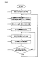
- FIG. 6 shows a flowchart of the processing for storing facility information as described in FIGS.
- FIG. 6 is a process that starts when the power of the route guidance device 1 is turned on. The process is executed by the control unit 10.
- control unit 10 specifies the current position of the mounted vehicle by calculating using the GPS receiving unit 14 or the like.
- the process proceeds to step S102.
- step S102 of FIG. 6 the control unit 10 searches for a facility within a predetermined distance from the current position specified in step S101, for example, within 100 m by facility search processing.
- a range of a predetermined distance from the current position of the mounted vehicle corresponds to the map ranges R1 to R3 in FIGS.
- step S103 of FIG. 6 the control unit 10 stores information regarding the facility searched for in step S102 in the storage unit 11. If the information regarding the facility is stored, the process proceeds to step S104.
- the information of the node closest to the current position, etc. it is memorized together with the information about the facility in step S103.
- the node closest to the current position of the mounted vehicle may be selected from the nodes at both ends of the link representing the road on which the mounted vehicle exists and stored.
- step S104 in FIG. 6 the control unit 10 uses the GPS receiving unit 14 and the gyro sensor 15 to initialize a travel distance variable representing the distance traveled by the mounted vehicle from the location where the facility search was performed in the previous step S102. Turn into.
- the initial value of the travel distance variable may be 0, for example.
- step S106 of FIG. 6 based on the current position specified in step S105, the value of the travel distance variable indicating the distance traveled from the place where the onboard vehicle has performed the facility search in step S102 is updated. For example, when the initial value of the travel distance variable is 0, it may be increased according to the travel distance of the mounted vehicle.
- step S107 of FIG. 6 the control unit 10 determines whether or not the value of the travel distance variable has exceeded a predetermined threshold value. For example, when the value of the travel distance variable exceeds a predetermined threshold, the process returns to step S102 to execute the facility search based on the current position of the mounted vehicle. If the value of the travel distance variable does not exceed the predetermined threshold, the process returns to step S105.
- the process of FIG. 6 searches for facilities around the current location of the mounted vehicle every time the mounted vehicle travels a predetermined distance after the power of the route guidance device 1 is turned on (when the travel distance variable exceeds a threshold).
- the discovered facility can be stored in the storage unit 11.
- FIG. 7 is a process that starts when the user requests to display information on the facility stored in the storage unit 11 or when the onboard vehicle is stopped. The process is performed by the control unit 10. Is done.
- control unit 10 displays a screen as shown in FIG. 5 on the display monitor 12 and displays information about the facility stored in the storage unit 11. If the information regarding a facility is displayed, it will progress to step S152.
- step S152 of FIG. 7 the control unit 10 determines whether or not a facility to be set as a destination or waypoint is selected from the information regarding the facility displayed in step S151. The process remains in step S152 until a facility is selected. If a facility is selected, the process proceeds to step S153.
- step S153 the control unit 10 sets the facility selected in step S152 as the destination or waypoint, and executes a route search process.
- the process proceeds to step S154.
- step S154 the control unit 10 performs a route guidance process based on the recommended route searched in step S153.
- the processing in FIG. 7 When the guidance of the mounted vehicle is completed, the processing in FIG.
- the route guidance device 1 includes a storage unit 11 that stores map data.
- the control unit 10 of the route guidance device 1 specifies the current position of the mounted vehicle using the GPS receiving unit 14 or the like (steps S101 and S105 in FIG. 6), and is a predetermined centered on the specified current position of the mounted vehicle.
- the control unit 10 searches for a facility for the map range of the distance (step S102 in FIG. 6), and the control unit 10 stores information on the facility found by the facility search in the storage unit 11 (step S103 in FIG. 6). Thereafter, in response to a request from the user, the control unit 10 displays information on facilities stored in the storage unit 11 (list 50 in FIG. 5, step S151 in FIG.
- Step S152 in FIG. 7 the selected facility is set as the destination or waypoint to search for a recommended route (step S153 in FIG. 7), and the mounted vehicle is guided according to the searched recommended route (FIG. 7). 7 step S154).
- the route guidance apparatus 1 can provide information regarding facilities in a familiar area where the user goes without searching for a route. As a result, it is possible to know a facility that has not been noticed in the vicinity of the user's action range.
- the control unit 10 searches for information on facilities around the current position of the mounted vehicle (FIG. 6 steps S104 to S107). Thereby, the load of the facility search process in the route guidance device 1 can be distributed. Further, it is not necessary to search for the facility again when displaying the list as shown in FIG. 5, and the response speed to the user's request can be increased.
- the route guidance device 1 when storing information about facilities around the current position of the mounted vehicle, the route nearest to the current position when the facility is searched is stored. Information may be further stored and displayed along with information about the facility (column 54 in FIG. 5). In this way, it is possible to clearly notify that the facility is located around a place familiar to the user.
- the distance from the current position of the mounted vehicle to each facility when the list 50 is displayed is displayed in column 53, but from the current position of the mounted vehicle when information about the facility is stored.
- the distance to each facility may be displayed. Thereby, the information regarding the distance from a familiar place can be provided to the user.
- the load regarding the process which calculates the distance to each facility can be disperse
- (1-B) Information on the facility is stored every time the mounted vehicle travels a predetermined distance, but may be stored every time a predetermined time has elapsed since it was stored in the storage unit 11 last time. .
- the time in that case, for example, the current time calculated by the control unit 10 based on the GPS signal may be used.
- the facility information stored in the storage unit 11 in step S103 of FIG. 6 may be stored even after the engine of the mounted vehicle is stopped and carried over to the next driving.
- a table including information on the facility stored in the past can be displayed as the list 50.
- it is desirable that the date and time when the information is stored is stored at the same time when the information about the facility is stored, and the information that is out of date can be deleted based on the information about the stored date and time.
- the information about the facility is the same as the past information, it may be determined that the facility is a facility in the area familiar to the user and displayed preferentially in the list.
- a route guidance device according to a second embodiment of the present invention.
- the configuration of the route guidance apparatus according to the second embodiment may be that of FIG. 1 described in the first embodiment.
- the route guidance device 1 according to the second embodiment searches for information stored in the storage unit 11 during traveling and facilities around the traveling locus. Is different.
- the control unit 10 executes a facility search process when requested by the user, and searches for information related to the facilities in the map ranges R1 to R3 around the current positions V1 to V3 of the mounted vehicles. As a result of the search, the control unit 10 finds the facility AAAA and the like, and displays the list 50 of FIG.
- FIG. 8 is a process that starts when the power of the route guidance device 1 is turned on. The process is executed by the control unit 10.
- control unit 10 specifies the current position of the mounted vehicle by calculating the current position using the GPS receiving unit 14 or the like.
- the process proceeds to step S202.
- step S202 of FIG. 8 the control unit 10 stores the current position of the mounted vehicle specified in step S201. By repeatedly performing step S202, the travel locus of the mounted vehicle is stored in the storage unit 11. When the storage of the current position is completed, the process proceeds to step S203.
- step S203 of FIG. 8 the control unit 10 initializes a travel distance variable representing the distance traveled by the mounted vehicle from the current position stored in the previous step S202, using the GPS receiver 14 and the gyro sensor 15 or the like.
- the initial value of the travel distance variable may be 0, for example.
- step S204 of FIG. 8 as in step S201, the control unit 10 specifies the current position of the mounted vehicle using the GPS receiving unit 14 or the like. When the specification of the current position of the mounted vehicle is completed, the process proceeds to step S205.
- step S205 of FIG. 8 the control unit 10 sets the value of the travel distance variable so as to indicate the distance traveled from the current position stored in step S202 by the mounted vehicle based on the current position of the mounted vehicle specified in step S204. Update. For example, when the initial value of the travel distance variable is set to 0, the value may be increased according to the travel distance.
- step S206 of FIG. 8 the control unit 10 determines whether or not the value of the travel distance variable has exceeded a predetermined threshold value. When the value of the travel distance variable exceeds a predetermined threshold value, the process returns to step S202 to execute the facility search based on the current position of the mounted vehicle. If the value of the travel distance variable does not exceed the predetermined threshold, the process returns to step S204.
- FIG. 9 shows a flowchart of processing for searching for a route to the destination or waypoint and guiding the mounted vehicle.
- FIG. 9 shows a process that is started when a user requests to display the facility information stored in the storage unit 11. The process is processed by the control unit 10.
- step S251 of FIG. 9 facility search processing is performed for each of the current positions of the mounted vehicles stored in the storage unit 11 to search for information on facilities in the vicinity of the travel locus. If information related to the facility in the vicinity of the travel locus is retrieved, the process proceeds to step S252.
- control unit 10 displays a screen as shown in FIG. 5 on the display monitor 12 and displays information on facilities around the traveling locus of the mounted vehicle stored in the storage unit 11. If the information regarding a facility is displayed, it will progress to step S253.
- step S253 of FIG. 9 the control unit 10 determines whether or not a facility is selected as a destination or waypoint from the information regarding the facility displayed in step S252. The control unit 10 remains in step S253 until the facility is selected, and proceeds to step S254 when the facility is selected.
- step S254 of FIG. 9 the control unit 10 executes a route search process using the facility selected in step S253 as the destination or waypoint.
- the process proceeds to step S255.
- step S255 of FIG. 9 the control unit 10 executes route guidance processing based on the recommended route searched in step S254.
- the processing in FIG. 9 is terminated.
- the route guidance device 1 includes a storage unit 11 that stores map information.
- the control unit 10 of the route guidance device 1 specifies the current position of the mounted vehicle by using the GPS receiving unit 14 (steps S201 and S204 in FIG. 8), and whenever the mounted vehicle travels a predetermined distance.
- the current position of the mounted vehicle calculated by the control unit 10 is stored in the storage unit 11 as a travel locus (steps S202 to S206 in FIG. 8).
- information on the facility is searched based on the current position of the mounted vehicle stored in the storage unit 11 (step S251 in FIG. 9), and the information on the searched facility is displayed on the display monitor 12. 5 (list 50 in FIG. 5, step S252 in FIG.
- step S253 in FIG. 9 accepts the selection of the facility via the input device 16 (step S253 in FIG. 9), and searches for the recommended route with the selected facility as the destination or waypoint Then, the mounted vehicle is guided according to the searched recommended route (step S255 in FIG. 9).
- the route guidance apparatus 1 does not perform a route search, it is possible to provide information regarding facilities around the travel locus. And it is a facility in a familiar area where the user goes without searching for a route, and information related to the facility that the user does not know can be provided. Also, unlike the first embodiment, by searching for facilities when displaying facility information, information based on the latest map data can be provided to the user.
- the current position of the mounted vehicle is stored every time the mounted vehicle travels a predetermined distance, but a predetermined time has elapsed since the current position of the mounted vehicle was stored in the storage unit 11 last time. It is good also as what is memorized every time.
- the time in that case may be the current time calculated by the control unit 10 based on the GPS signal.
- the current position of the mounted vehicle stored in the storage unit 11 in step S202 of FIG. 8 may be stored even after the engine of the mounted vehicle is stopped and carried over to the next driving.
- the facility search is performed for the current position of the mounted vehicle stored in the past, and the list 50 can be displayed.
- the date and time stored when storing the current position of the mounted vehicle are stored at the same time, and the mounted vehicle that has become old based on the information related to the stored date It is desirable to be able to delete the current location.
- the facility when the same facility is searched a plurality of times in the facility search process, it may be determined that the facility is a local facility familiar to the user and displayed preferentially in the list. In this case, when displaying the name of a spot in the vicinity of the facility as shown in the column 54 of FIG. 5, information based on the current position of the mounted vehicle closest to the facility may be displayed.
- step S251 of FIG. 9 the control unit 10 searches for facilities within a predetermined distance from each of the current positions of the mounted vehicles stored in the storage unit 11. However, based on the current position of the mounted vehicle, a map range indicating the periphery of the track of the mounted vehicle may be set, and the facility may be searched based on the map range. Thereby, the frequency
Abstract
経路案内装置は、施設に関する情報を含む地図情報を記憶する地図情報記憶部と、車両の位置を特定する車両位置特定部と、車両位置特定部により特定された車両の位置に基づき、地図情報を使用して施設を検索する施設検索部と、施設検索部により検索された施設に関する情報を表示する施設表示部と、施設表示部により情報が表示された施設の中から目的地または経由地として設定する施設を選択する施設選択部と、施設選択部により選択された施設を目的地または経由地とした推奨経路を探索する経路探索部と、経路探索部により探索された推奨経路にしたがって車両を誘導する経路誘導部とを備える。
Description
本発明は、経路案内装置に関する。
従来、利用者が設定した目的地に対して経路を探索し、探索の結果得られた経路の周辺の施設を検索する経路案内装置が存在する(たとえば、特許文献1)。
経路案内装置の利用者は、目的地が利用者にとって身近な場所であった場合に経路探索を行わないことがある。従来の経路案内装置では、経路探索を行わなかった場合、自車両が通る道路周辺の施設を検索することができない。そのため、従来の経路案内装置では、利用者にとって身近な場所の周辺にある施設に関して利用者に情報を提供することができなかった。
本発明の第1の態様によると、経路案内装置は、施設に関する情報を含む地図情報を記憶する地図情報記憶部と、車両の位置を特定する車両位置特定部と、車両位置特定部により特定された車両の位置に基づき、地図情報を使用して施設を検索する施設検索部と、施設検索部により検索された施設に関する情報を表示する施設表示部と、施設表示部により情報が表示された施設の中から目的地または経由地として設定する施設を選択する施設選択部と、施設選択部により選択された施設を目的地または経由地とした推奨経路を探索する経路探索部と、経路探索部により探索された推奨経路にしたがって車両を誘導する経路誘導部とを備える。
本発明の第2の態様によると、第1の態様の経路案内装置において、施設検索部により検索された施設に関する情報を記憶する施設記憶部をさらに備え、施設検索部は、車両の走行中に、地図情報を使用して、特定された車両の位置から所定距離以内にある施設を検索し、施設記憶部は、車両の走行中に施設検索部により検索された施設に関する情報を記憶し、施設表示部は、施設記憶部が記憶した情報に基づいて、施設検索部により検索された施設に関する情報を表示するのが好ましい。
本発明の第3の態様によると、第2の態様の経路案内装置において、施設検索部は、車両が所定の距離を移動するたびに、または所定時間が経過するたびに車両の位置から所定距離以内にある施設を検索するのが好ましい。
本発明の第4の態様によると、第2または第3の態様の経路案内装置において、施設記憶部は、施設検索部により検索された施設に関する情報を、当該施設が検索されたときの車両の位置に関する情報とともに記憶し、施設表示部は、施設に関する情報を、当該施設が検索されたときの車両の位置に関する情報とともに表示するのが好ましい。
本発明の第5の態様によると、第1の態様の経路案内装置において、車両の移動中に車両位置特定部により特定された車両の位置に基づく車両の走行軌跡を記憶する車両位置記憶部をさらに備え、施設検索部は、地図情報に基づいて、車両位置記憶部により記憶された走行軌跡から所定距離以内にある施設を検索し、施設表示部は、施設検索部により検索された施設に関する情報を表示するのが好ましい。
本発明の第6の態様によると、第5の態様の経路案内装置において、施設表示部は、施設検索部により検索された施設に関する情報を、車両の走行軌跡のうちで当該施設に最も近い車両の位置に関する情報とともに表示するのが好ましい。
本発明によれば、利用者が目的地を設定せず、経路探索を行わなかった場合であっても、利用者が移動した走行軌跡周辺にある施設に関して情報を提供することができる。これにより、本発明の経路案内装置は利用者にとって身近な場所の周辺にある施設に関して情報を提供することができる。
-第一の実施の形態-
本発明の一実施の形態による経路案内装置の構成について、図1を用いて説明する。図1の経路案内装置1は、制御部10、記憶部11、表示モニタ12、スピーカ13、GPS受信部14、ジャイロセンサ15、および入力装置16を備え、車両に搭載される。以降、経路案内装置1を搭載した車両のことを搭載車両と記載する。
本発明の一実施の形態による経路案内装置の構成について、図1を用いて説明する。図1の経路案内装置1は、制御部10、記憶部11、表示モニタ12、スピーカ13、GPS受信部14、ジャイロセンサ15、および入力装置16を備え、車両に搭載される。以降、経路案内装置1を搭載した車両のことを搭載車両と記載する。
図1の制御部10は、経路案内装置1を動作させるための各種処理を実行するための部分であり、マイクロプロセッサ、各種周辺回路、RAM、ROMなどによって構成される。制御部10により実行される処理には、たとえば経路探索処理や、施設検索処理、経路誘導処理などがある。これらの処理については、多くの手法が公知となっている。
制御部10が実行する経路探索処理とは、利用者が設定した探索条件に基づいて、搭載車両の現在位置から目的地までの経路の中で到着までにかかる時間が最も短い経路を推奨経路として探索するものである。目的地は、経路案内装置1の利用者が入力装置16を介して入力すればよい。搭載車両の現在位置は、制御部10がGPS受信部14を利用して算出することにより特定できる。経路の探索は、記憶部11に記憶されている地図データに基づいて実行される。なお、推奨経路を探索するとき、目的地だけでなく経由地を選択することとしてもよい。
制御部10が実行する施設検索処理とは、施設のジャンルやキーワードに基づいて、記憶部11に記憶されている施設データの中から、搭載車両の現在位置または推奨経路の周辺にある施設を検索するものである。施設の検索に利用する施設のジャンルやキーワードは、経路案内装置1の利用者が入力装置16を介して入力することができる。施設のジャンルとは、施設をその用途などで分類したもので、たとえば「交通機関」、「公共施設」、「医療」などでよい。
制御部10が実行する経路誘導処理とは、経路探索処理により探索された推奨経路に沿って運転手が搭載車両を運転できるように、表示モニタ12やスピーカ13などを利用して運転手に案内を行い、搭載車両を誘導するものである。制御部10は、表示モニタ12に搭載車両の位置を示す印を付した地図を表示し、スピーカ13から音声案内を出力する。
図1の記憶部11は、ハードディスクなどの不揮発性の記憶媒体であり、地図データや画像データ、音声データを含む各種データが記憶されている。記憶部11に記憶されているデータは、必要に応じて制御部10により記憶部11から読み出され、制御部10が実行する様々な処理や制御に利用される。また、制御部10は、記憶部11に新たなデータを記憶することや既に記憶されているデータを更新することができる。
記憶部11に記憶される地図データには、地図上の場所を表すノードに関する情報と、ノードが表す場所と場所の間を繋ぐ道路を表すリンクに関する情報とが含まれる。ノードに関する情報には、位置情報や地点名称に関する情報などが含まれる。リンクに関する情報には、リンクが表す道路を通過するのにかかる時間を割り出すための情報や、道路種別、車両の通行が許可されている方向などの情報が含まれる。これらの情報に基づいて経路探索処理や経路誘導処理が実行される。
記憶部11に記憶されている地図データには、施設データが含まれる。施設データには、施設名や施設の位置、施設のジャンルなどの情報が含まれる。制御部10は、施設データを利用して前述した施設検索処理を実行することができる。また、前述した経路誘導処理において、表示モニタ12に表示している地図上に施設を表す印を表示することができる。
図1の表示モニタ12は、様々な画像や映像などを表示するための装置であり、液晶ディスプレイ等が用いられる。制御部10の制御に基づいて表示モニタ12に地図や搭載車両の位置を表示することにより、ナビゲーション装置1は搭載車両を誘導することができる。
図1のスピーカ13は、制御部10の制御により、搭載車両の走行に関する様々な音声情報を出力する。たとえば、制御部10により探索された経路に従って搭載車両を目的地まで案内するための案内用の音声や、警告音などを出力する。
図1のGPS受信部14は、GPS衛星から送信されるGPS信号を受信して制御部10へ出力する。GPS信号には、搭載車両の現在位置と現在時刻を特定するための情報として、そのGPS信号を送信したGPS衛星の位置と送信時刻が含まれている。したがって、制御部10は、所定数以上のGPS衛星からGPS信号を受信することにより、これらの情報に基づいて搭載車両の現在位置および現在時刻を算出し、特定することができる。制御部10は、GPS信号に基づいて算出された搭載車両の現在位置の時間変化を算出し、その搭載車両の現在位置の時間変化に基づいて、搭載車両が走行している方向と走行した距離を特定することができる。
図1のジャイロセンサ15は、搭載車両の向きの変化に応じた角速度を検出するためのセンサである。このジャイロセンサ15により検出された角速度に基づいて、搭載車両の向きが求められ、搭載車両が走行している方向を特定できる。
図1の入力装置16は、経路案内装置1を動作させるためにユーザから入力される各種操作を検出するための装置であり、各種の入力スイッチ類を有している。ユーザは、入力装置16を操作することにより、たとえば、目的地に設定したい施設や地名等を入力したり、予め登録された登録地の中から目的地を選択したり、表示モニタ12に表示された地図を任意の方向にスクロールしたりすることができる。入力装置16は、操作パネルやリモコンなどによって実現することができる。あるいは、入力装置16を表示モニタ12と一体化されたタッチパネルとしてもよい。
経路案内装置1は、ブラケットにより搭載車両に固定されると共に、ハーネスを介して搭載車両と種々の信号の送受信を行うことができる。これにより、経路案内装置1は、たとえば、イグニッションキーがオンになったことや、搭載車両の走行速度などの情報を取得することができる。
搭載車両がトンネル内を走行しているときや、高架下にあるサービスエリア内にあるときなど、GPS受信部14がGPS信号を受信できない場合がある。制御部10は、ジャイロセンサ15により検出される角速度、搭載車両から送信される搭載車両の走行速度、および記憶部11に記憶される地図データに基づいて、搭載車両の現在位置および走行している方向に関する情報を特定することができ、GPS受信部14により定期的に受信されるGPS信号に基づいて、それらの情報の補正を行っている。
次に第一の実施の形態における、搭載車両が走行した走行軌跡周辺にある施設の情報を提供する方法について説明する。第一の実施の形態では、搭載車両が所定の距離を走行するたびに前述した施設検索処理を実行し、その結果得られた施設に関する情報を記憶部11などに記憶する。そして、その記憶した施設に関する情報に基づいて検索された施設を表示し、利用者に施設に関する情報を提供する。
図2から図4を用いて、経路案内装置1が走行軌跡周辺にある施設の情報を記憶していく様子を説明する。
図2は、搭載車両が現在位置V1を走行しているときに、制御部10が搭載車両の現在位置周辺にある施設を検索している様子を示している。図2では、搭載車両を誘導するための地図を表示モニタ12に表示しており、搭載車両の現在位置V1に対応する場所に搭載車両を表す印を表示している。図2では、搭載車両を三角の印で表しており、その向きにより搭載車両の走行方向を示している。制御部10は、搭載車両の現在位置V1を中心とした地図範囲R1の内側にある施設を前述した施設検索処理により検索しており、施設AAAAが検索により発見されている。制御部10は、施設AAAAのように施設検索処理により発見された施設に関する情報を施設データから抽出し、記憶部11に記憶する。なお、地図範囲R1を表す点線および発見された施設AAAAは、説明のために示したものであって、表示モニタ12に表示しなくてもよい。
制御部10が現在位置V1において施設検索処理を実行するとき、検索する施設のジャンルは事前に利用者により設定してもよいし、すべてのジャンルについて施設を検索し、記憶部11に記憶してもよい。
図3は、図2の状態から搭載車両が所定の距離を走行し、現在位置V2にいる状態を示している。このとき、制御部10は、図2の場合と同様に搭載車両の現在位置V2を中心とした地図範囲R2について施設検索処理を実行し、施設BBBBを発見する。そして、制御部10は、施設AAAAと同様に、発見された施設BBBBに関する情報を記憶部11に記憶する。なお、地図範囲R2を表す点線および発見された施設BBBBは、説明のために示したものであって、表示モニタ12に表示しなくてもよい。
図4は、図3の状態から更に搭載車両が所定の距離を走行し、現在位置V3にいる状態を示している。このとき、制御部10は、搭載車両の現在位置V3を中心とした地図範囲R3について施設検索処理を実行し、施設CCCCおよびDDDDを発見する。そして、制御部10は、施設AAAAおよびBBBBと同様に、発見された施設CCCCおよびDDDDに関する情報を記憶部11に記憶する。なお、地図範囲R3を表す点線および発見された施設CCCCおよびDDDDは、説明のために示したものであって、表示モニタ12に表示しなくてもよい。
図2から図4に示したように、搭載車両が所定の距離を走行するたびに搭載車両の現在位置を中心とした地図範囲について施設検索処理を実行し、検索によって発見された施設に関する情報を記憶部11に記憶し、施設の情報を蓄積する。なお、施設に関する情報を記憶するとき、施設を発見したときの搭載車両の現在位置や、現在位置から最も近い位置にあるノードの情報などを付加して記憶してもよい。これにより、ノードの情報に基づいて搭載車両の現在位置を地点名称に変換することができる。
図5は、記憶部11に記憶した施設に関する情報を表示した表示モニタ12の表示例である。制御部10は、利用者が入力装置16を介して記憶部11に記憶した施設に関する情報の表示を要請したとき、記憶部11から施設に関する情報を読み出し、図5に示す一覧表50を作成する。一覧表50には、施設データに含まれる施設のジャンルを表示する列51や施設名を表示する列52、搭載車両の現在位置からの距離を表示する列53などが含まれる。また、施設データとともに記憶した現在位置から最も近い位置にあるノードの情報などに基づいて、施設の近隣にある地点名称を表示する列54を表示してもよい。図5の列54は、搭載車両の現在位置V1~V3から最も近いノードの地点名称として「ABC町X丁目付近」などを表示している。表示する地点名称は、ノードに関する情報に基づけばよく、交差点名などでもよい。また、制御部10は、搭載車両が走行している車線に対応したリンクの情報に基づき、ノードに関する情報を選択し、表示する地点名称を決定してもよい。
また、図5のように、一覧表50のほかに表示モニタ12上にカーソル60や目的地設定ボタン61、絞込み検索ボタン62などを表示してもよい。経路案内装置1の利用者は、入力装置16を介してカーソル60を選択したい施設の上に動かし、入力装置16を介してカーソル60がある施設を選択してもよい。そして、利用者は入力装置16を介して目的地設定ボタン61を選択することにより、先ほど選択された施設を目的地として設定することにしてもよい。また、絞込み検索ボタン62を選択し、施設のジャンルなどにより一覧表50に表示する施設を絞り込んでもよい。
図2~図4で説明したような施設の情報を記憶する処理について、フローチャートを図6に示す。図6は、経路案内装置1の電源がオンされたときに開始する処理であり、その処理は制御部10で実行される。
図6のステップS101では、制御部10は、搭載車両の現在位置を、GPS受信部14などを利用して算出することにより特定する。搭載車両の現在位置の特定が完了したらステップS102に進む。
図6のステップS102では、制御部10は、ステップS101で特定した現在位置から所定の距離以内、たとえば100m以内にある施設を施設検索処理により検索する。この搭載車両の現在位置から所定の距離の範囲が図2~図4における地図範囲R1~R3に相当する。検索が完了したらステップS103に進む。
図6のステップS103では、制御部10は、ステップS102で検索した施設について、その施設に関する情報を記憶部11に記憶する。施設に関する情報を記憶したらステップS104に進む。なお、施設を発見したときの搭載車両の現在位置や、現在位置から最も近い位置にあるノードの情報などを記憶させる場合は、ステップS103において施設に関する情報とともに記憶させる。搭載車両の現在位置に最も近い位置にあるノードは、搭載車両が存在している道路を表すリンクの両端にあるノードの中から選択し、記憶すればよい。
図6のステップS104では、制御部10は、GPS受信部14やジャイロセンサ15などを利用して、前回ステップS102で施設検索を行った場所から搭載車両が走行した距離を表す走行距離変数を初期化する。走行距離変数の初期値は、たとえば0とすればよい。初期化が完了したらステップS105に進む。
図6のステップS105では、ステップS101と同様に、制御部10は、GPS受信部14などを利用して搭載車両の現在位置を特定する。搭載車両の現在位置の特定が完了したらステップS106に進む。
図6のステップS106では、ステップS105で特定した現在位置に基づいて、搭載車両がステップS102で施設検索を行った場所から走行した距離を示す走行距離変数の値を更新する。たとえば、走行距離変数の初期値が0の場合は、搭載車両の走行距離に応じて増加させればよい。
図6のステップS107では、制御部10は、走行距離変数の値が所定の閾値を超えたか否かを判定する。たとえば、走行距離変数の値が所定の閾値を超えた場合は、搭載車両の現在位置に基づいて施設検索を実行するためにステップS102に戻る。走行距離変数の値が所定の閾値を超えていない場合は、ステップS105に戻る。
図6の処理により、経路案内装置1の電源がオンになってから搭載車両が所定の距離を走行するたび(走行距離変数が閾値を超えるたび)に搭載車両の現在地周辺の施設を検索し、発見された施設を記憶部11に記憶することができる。
次に図5を用いて説明したように記憶部11に記憶した施設に関する情報を表示し、その中から選択された目的地または経由地への経路を探索し、搭載車両を誘導する処理について、フローチャートを図7に示す。図7は、記憶部11に記憶した施設の情報を表示することを利用者から要請されたときや搭載車両が停車しているときなどに開始する処理であり、その処理は制御部10で処理される。
図7のステップS151では、制御部10が表示モニタ12に図5のような画面を表示し、記憶部11に記憶された施設に関する情報を表示する。施設に関する情報を表示したらステップS152に進む。
図7のステップS152では、制御部10は、ステップS151で表示した施設に関する情報の中から目的地または経由地として設定する施設が選択されたか否かを判定する。施設が選択されるまでステップS152に留まり、施設が選択された場合はステップS153に進む。
図7のステップS153では、制御部10は、ステップS152で選択された施設を目的地または経由地として設定し、経路探索処理を実行する。経路探索処理により推奨経路が探索されたらステップS154に進む。
図7のステップS154では、制御部10は、ステップS153で探索された推奨経路に基づいて経路誘導処理を実行する。搭載車両の誘導が完了したら図7の処理を終了する。
以上説明した実施形態によれば、次の作用効果を奏する。
(1-1)第一の実施の形態による経路案内装置1は、地図データを記憶する記憶部11を備える。経路案内装置1の制御部10は、GPS受信部14などを利用して搭載車両の現在位置を特定し(図6のステップS101,S105)、特定された搭載車両の現在位置を中心とした所定の距離の地図範囲について制御部10が施設を検索し(図6のステップS102)、施設検索により発見された施設に関する情報を制御部10が記憶部11に記憶する(図6のステップS103)。その後、利用者からの要請に応じて制御部10が記憶部11に記憶した施設に関する情報を表示し(図5の一覧表50、図7のステップS151)、入力装置16を介した施設の選択を受付け(図7のステップS152)、選択された施設を目的地または経由地に設定して推奨経路を探索し(図7のステップS153)、探索された推奨経路に従って搭載車両を誘導する(図7のステップS154)。これにより、経路案内装置1の利用者が経路探索をしなかった場合でも走行軌跡周辺の施設に関する情報を提供することができる。そして、経路案内装置1は、利用者が経路探索をしないで行くような身近な地域にある施設に関しても情報を提供することができる。これにより利用者の行動範囲周辺にありながら気付かなかったような施設を知ることができる。
(1-2)第一の実施の形態による経路案内装置1では、搭載車両が所定の距離を走行するたびに制御部10が搭載車両の現在位置の周辺にある施設に関する情報を検索する(図6のステップS104~S107)。これにより、経路案内装置1における施設検索処理の負荷を分散することができる。また、図5のような一覧表を表示するときに改めて施設を検索する必要がなくなり、利用者の要請に対する応答速度を速くすることができる。
(1-3)第一の実施の形態による経路案内装置1では、搭載車両の現在位置の周辺にある施設に関する情報を記憶するとき、当該施設が検索されたときの現在位置に最も近いノードの情報を更に記憶してもよく、その情報を施設に関する情報とともに表示してもよい(図5の列54)。このようにすれば、利用者にとって身近な場所の周辺にある施設であることを明確に知らしめることができる。
以上の第一の実施の形態は、以下のように変形して実施できる。
(1-A)図5において、一覧表50を表示したときの搭載車両の現在位置から各施設までの距離を列53に表示したが、施設に関する情報を記憶したときの搭載車両の現在位置から各施設までの距離を表示してもよい。これにより、身近な場所からの距離に関する情報を利用者に提供することができる。また、各施設までの距離を算出する処理に関する負荷を搭載車両の走行中に分散させることができる。
(1-B)搭載車両が所定の距離を走行するたびに施設に関する情報を記憶するものとしたが、前回記憶部11に記憶してから所定の時間が経過するたびに記憶するものとしてもよい。その場合の時間は、たとえば制御部10がGPS信号に基づいて算出した現在時刻を用いればよい。
(1-C)図6のステップS103において記憶部11に記憶した施設の情報は搭載車両のエンジンが停止された後にも記憶しておき、次回の運転に持ち越してもよい。記憶部11に記憶した施設の情報を持ち越す場合、過去に記憶した施設に関する情報を含めた表を一覧表50として表示することができる。なお、記憶部11の容量保護のため、施設に関する情報を記憶する際に情報を記憶した日時を同時に記憶し、記憶した日時に関する情報に基づいて古くなった情報を削除できることが望ましい。また、施設に関する情報が過去の情報と同一のものであったとき、利用者にとって身近な地域の施設であると判断して一覧表において優先的に表示することにしてもよい。
-第二の実施の形態-
次に、本発明の第二の実施形態による経路案内装置について説明する。第二の実施形態による経路案内装置の構成は、第一の実施形態で説明した図1のものでよい。第二の実施形態による経路案内装置1は、前述の第一の実施形態による経路案内装置1と比較して、走行中に記憶部11に記憶する情報と、走行軌跡周辺の施設を検索するタイミングとが異なる。
次に、本発明の第二の実施形態による経路案内装置について説明する。第二の実施形態による経路案内装置の構成は、第一の実施形態で説明した図1のものでよい。第二の実施形態による経路案内装置1は、前述の第一の実施形態による経路案内装置1と比較して、走行中に記憶部11に記憶する情報と、走行軌跡周辺の施設を検索するタイミングとが異なる。
第二の実施形態では、搭載車両が所定の距離を走行するたびに搭載車両の現在位置を記憶部11に記憶することで、搭載車両の走行軌跡を記憶する。そして、経路案内装置1の利用者から施設に関する情報を表示するよう要請があったとき、記憶部11に記憶した走行軌跡の周囲について施設検索処理を実行し、発見された施設の一覧表を表示する。たとえば、図2~図4のような状況においては、施設AAAAなどではなく、現在位置V1~V3を記憶部11に記憶する。そして、制御部10は、利用者から要請があったときに施設検索処理を実行し、記憶した搭載車両の現在位置V1~V3の周辺の地図範囲R1~R3にある施設に関する情報を検索する。制御部10は検索の結果、施設AAAAなどを発見し、図5の一覧表50を表示モニタ12に表示する。
第ニの実施の形態において、車両の現在位置を記憶部11に記憶する処理について図8を用いて説明する。図8は、経路案内装置1の電源がオンされたときに開始する処理であり、その処理は制御部10で実行される。
図8のステップS201では、制御部10は、GPS受信部14などを利用して搭載車両の現在位置を算出することにより特定する。搭載車両の現在位置の特定が完了したらステップS202に進む。
図8のステップS202では、制御部10はステップS201で特定した搭載車両の現在位置を記憶する。このステップS202が繰り返し行われることにより、搭載車両の走行軌跡が記憶部11に記憶される。現在位置の記憶が完了したらステップS203に進む。
図8のステップS203では、制御部10は、GPS受信部14やジャイロセンサ15などを利用して、前回ステップS202で記憶した現在位置から搭載車両が走行した距離を表す走行距離変数を初期化する。走行距離変数の初期値はたとえば0とすればよい。走行距離変数の初期化が完了したらステップS204に進む。
図8のステップS204では、ステップS201と同様に、制御部10は、GPS受信部14などを利用して搭載車両の現在位置を特定する。搭載車両の現在位置の特定が完了したらステップS205に進む。
図8のステップS205では、制御部10は、ステップS204で特定した搭載車両の現在位置に基づいて、搭載車両がステップS202で記憶した現在位置から走行した距離を示すように走行距離変数の値を更新する。たとえば、走行距離変数の初期値を0とした場合は、その値を走行距離に応じて増加させればよい。
図8のステップS206では、制御部10は、走行距離変数の値が所定の閾値を超えたか否かを判定する。走行距離変数の値が所定の閾値を超えた場合は、搭載車両の現在位置に基づいて施設検索を実行するためにステップS202に戻る。走行距離変数の値が所定の閾値を超えていない場合は、ステップS204に戻る。
次に第二の実施形態において、記憶部11に記憶した搭載車両の現在位置(走行軌跡)に基づいて施設に関する情報を検索し、検索された施設に関する情報を表示し、その中から選択された目的地または経由地への経路を探索し、搭載車両を誘導する処理について、フローチャートを図9に示す。図9は、記憶部11に記憶した施設の情報を表示することを利用者から要請されたときなどに開始する処理であり、その処理は制御部10で処理される。
図9のステップS251では、記憶部11に記憶された搭載車両の現在位置それぞれについて施設検索処理を行い、走行軌跡の周辺にある施設に関する情報を検索する。走行軌跡の周辺にある施設に関する情報を検索したらステップS252に進む。
図9のステップS252では、制御部10は、表示モニタ12に図5のような画面を表示し、記憶部11に記憶された搭載車両の走行軌跡周辺にある施設に関する情報を表示する。施設に関する情報を表示したらステップS253に進む。
図9のステップS253では、制御部10は、ステップS252で表示した施設に関する情報の中から目的地または経由地として施設が選択されたか否かを判定する。制御部10は、施設が選択されるまでステップS253に留まり、施設が選択された場合はステップS254に進む。
図9のステップS254では、制御部10は、ステップS253で選択された施設を目的地または経由地として経路探索処理を実行する。経路探索処理により推奨経路が探索されたらステップS255に進む。
図9のステップS255では、制御部10は、ステップS254で探索された推奨経路に基づいて経路誘導処理を実行する。搭載車両の誘導が完了したら図9の処理を終了する。
以上説明した実施形態によれば、次の作用効果を奏する。
(2-1)第二の実施の形態による経路案内装置1は、地図情報を記憶する記憶部11を備える。経路案内装置1の制御部10は、GPS受信部14を利用して搭載車両の現在位置を算出することにより特定し(図8のステップS201,S204)、搭載車両が所定の距離を走行するたびに制御部10が算出した搭載車両の現在位置を走行軌跡として記憶部11に記憶する(図8のステップS202~S206)。その後、利用者からの要請に応じて、記憶部11に記憶した搭載車両の現在位置に基づいて施設に関する情報を検索し(図9のステップS251)、検索した施設に関する情報を表示モニタ12に表示し(図5の一覧表50、図9のステップS252)、入力装置16を介して施設の選択を受けつけ(図9のステップS253)、選択された施設を目的地または経由地として推奨経路を探索し(図9のステップS254)、探索された推奨経路に従って搭載車両を誘導する(図9のステップS255)。これにより、経路案内装置1の利用者が経路探索をしなかった場合でも走行軌跡周辺の施設に関する情報を提供することができる。そして、利用者が経路探索をしないで行くような身近な地域にある施設であって、利用者が知らない施設に関する情報を提供できる。また、第一の実施形態と違い、施設の情報を表示するときに施設の検索を行うことにより、最新の地図データに基づいた情報を利用者に提供できる。
以上の第二の実施の形態は、以下のように変形して実施できる。
(2-A)図5において、一覧表50の列53に搭載車両の現在位置から施設までの距離を表示したが、施設検索処理時に施設が発見された搭載車両の現在位置からの距離を表示してもよい。これにより、身近な場所からの距離に関する情報を利用者に提供することができる。
(2-B)搭載車両が所定の距離を走行するたびに搭載車両の現在位置を記憶するものとしたが、前回に記憶部11に搭載車両の現在位置を記憶してから所定の時間が経過するたびに記憶するものとしてもよい。その場合の時間は、制御部10がGPS信号に基づいて算出した現在時刻を用いればよい。
(2-C)図8のステップS202において記憶部11に記憶した搭載車両の現在位置は、搭載車両のエンジンが停止された後にも記憶しておき、次回の運転に持ち越してもよい。記憶部11に記憶した搭載車両の現在位置を持ち越す場合、過去に記憶した搭載車両の現在位置についても施設検索を行い、一覧表50を表示することができる。なお、記憶部11の容量保護および施設検索処理における処理負荷軽減のため、搭載車両の現在位置を記憶する際に記憶した日時を同時に記憶し、記憶した日時に関する情報に基づいて古くなった搭載車両の現在位置を削除できることが望ましい。
また、施設検索処理において同一の施設が複数回検索された場合、利用者にとって身近な地域の施設であると判断して一覧表において優先的に表示することにしてもよい。このよう場合に、図5の列54のように施設の近隣にある地点名称を表示するときは、施設に最も近い搭載車両の現在位置に基づいた情報を表示することにしてもよい。
(2-D)図9のステップS251において、制御部10は記憶部11に記憶されている搭載車両の現在位置それぞれから所定の距離の範囲の施設を検索した。しかし、搭載車両の現在位置に基づいて、搭載車両の軌跡の周辺を示す地図範囲を設定し、その地図範囲に基づいて施設を検索することにしてもよい。これにより、施設に関する情報を表示する際に実行する施設検索処理の回数を低減することができ、制御部10の負荷を低減できる。
以上説明した各実施の形態や各種の変形例は、車両以外のものに適用してもよい。たとえば、歩行者を誘導する経路案内装置に適用してもよい。
以上説明した各実施の形態や各種の変形例はあくまで一例であり、発明の特徴が損なわれない限り、本発明はこれらの内容に限定されるものではない。
次の優先権基礎出願の開示内容は引用文としてここに組み込まれる。
日本国特許出願2010年第046713号(2010年3月3日出願)
日本国特許出願2010年第046713号(2010年3月3日出願)
Claims (6)
- 施設に関する情報を含む地図情報を記憶する地図情報記憶部と、
車両の位置を特定する車両位置特定部と、
前記車両位置特定部により特定された車両の位置に基づき、前記地図情報を使用して施設を検索する施設検索部と、
前記施設検索部により検索された施設に関する情報を表示する施設表示部と、
前記施設表示部により情報が表示された施設の中から目的地または経由地として設定する施設を選択する施設選択部と、
前記施設選択部により選択された施設を前記目的地または前記経由地とした推奨経路を探索する経路探索部と、
前記経路探索部により探索された前記推奨経路にしたがって前記車両を誘導する経路誘導部とを備える経路案内装置。 - 請求項1に記載の経路案内装置において、
前記施設検索部により検索された前記施設に関する情報を記憶する施設記憶部をさらに備え、
前記施設検索部は、前記車両の走行中に、前記地図情報を使用して、前記特定された車両の位置から所定距離以内にある施設を検索し、
前記施設記憶部は、前記車両の走行中に前記施設検索部により検索された前記施設に関する情報を記憶し、
前記施設表示部は、前記施設記憶部が記憶した情報に基づいて、前記施設検索部により検索された施設に関する情報を表示する経路案内装置。 - 請求項2に記載の経路案内装置において、
前記施設検索部は、前記車両が所定の距離を移動するたびに、または所定時間が経過するたびに前記車両の位置から所定距離以内にある施設を検索する経路案内装置。 - 請求項2または3に記載の経路案内装置おいて、
前記施設記憶部は、前記施設検索部により検索された施設に関する情報を、当該施設が検索されたときの前記車両の位置に関する情報とともに記憶し、
前記施設表示部は、前記施設に関する情報を、当該施設が検索されたときの前記車両の位置に関する情報とともに表示する経路案内装置。 - 請求項1に記載の経路案内装置において、
前記車両の移動中に前記車両位置特定部により特定された前記車両の位置に基づく前記車両の走行軌跡を記憶する車両位置記憶部をさらに備え、
前記施設検索部は、前記地図情報に基づいて、前記車両位置記憶部により記憶された前記走行軌跡から所定距離以内にある施設を検索し、
前記施設表示部は、前記施設検索部により検索された施設に関する情報を表示する経路案内装置。 - 請求項5に記載の経路案内装置において、
前記施設表示部は、前記施設検索部により検索された施設に関する情報を、前記車両の走行軌跡のうちで当該施設に最も近い車両の位置に関する情報とともに表示する経路案内装置。
Applications Claiming Priority (2)
| Application Number | Priority Date | Filing Date | Title |
|---|---|---|---|
| JP2010-046713 | 2010-03-03 | ||
| JP2010046713A JP2011180079A (ja) | 2010-03-03 | 2010-03-03 | 経路案内装置 |
Publications (1)
| Publication Number | Publication Date |
|---|---|
| WO2011108591A1 true WO2011108591A1 (ja) | 2011-09-09 |
Family
ID=44542238
Family Applications (1)
| Application Number | Title | Priority Date | Filing Date |
|---|---|---|---|
| PCT/JP2011/054773 WO2011108591A1 (ja) | 2010-03-03 | 2011-03-02 | 経路案内装置 |
Country Status (2)
| Country | Link |
|---|---|
| JP (1) | JP2011180079A (ja) |
| WO (1) | WO2011108591A1 (ja) |
Families Citing this family (1)
| Publication number | Priority date | Publication date | Assignee | Title |
|---|---|---|---|---|
| JP5921162B2 (ja) * | 2011-11-24 | 2016-05-24 | 富士通テン株式会社 | 車両用装置、目的地の設定方法、及びプログラム |
Citations (4)
| Publication number | Priority date | Publication date | Assignee | Title |
|---|---|---|---|---|
| JP2002139324A (ja) * | 2000-10-30 | 2002-05-17 | Honda Motor Co Ltd | 通信型ナビゲーションシステム |
| JP2006258441A (ja) * | 2005-03-15 | 2006-09-28 | Sony Corp | 地点検索装置、検索方法 |
| JP2008196998A (ja) * | 2007-02-14 | 2008-08-28 | Denso Corp | ナビゲーション装置 |
| JP2009281840A (ja) * | 2008-05-22 | 2009-12-03 | Alpine Electronics Inc | 車載用ナビゲーション装置及び周辺施設検索表示方法 |
-
2010
- 2010-03-03 JP JP2010046713A patent/JP2011180079A/ja not_active Withdrawn
-
2011
- 2011-03-02 WO PCT/JP2011/054773 patent/WO2011108591A1/ja active Application Filing
Patent Citations (4)
| Publication number | Priority date | Publication date | Assignee | Title |
|---|---|---|---|---|
| JP2002139324A (ja) * | 2000-10-30 | 2002-05-17 | Honda Motor Co Ltd | 通信型ナビゲーションシステム |
| JP2006258441A (ja) * | 2005-03-15 | 2006-09-28 | Sony Corp | 地点検索装置、検索方法 |
| JP2008196998A (ja) * | 2007-02-14 | 2008-08-28 | Denso Corp | ナビゲーション装置 |
| JP2009281840A (ja) * | 2008-05-22 | 2009-12-03 | Alpine Electronics Inc | 車載用ナビゲーション装置及び周辺施設検索表示方法 |
Also Published As
| Publication number | Publication date |
|---|---|
| JP2011180079A (ja) | 2011-09-15 |
Similar Documents
| Publication | Publication Date | Title |
|---|---|---|
| US7769541B2 (en) | Vehicle navigation system and method of generating updated map data for vehicle navigation system | |
| US6529822B1 (en) | Navigation system with zoomed maneuver instruction | |
| US7400973B2 (en) | Navigation apparatus for route search | |
| US7813874B2 (en) | On-vehicle navigation system, route guide method, and computer-readable recording medium | |
| JPWO2005093373A1 (ja) | ナビゲーション装置、経路探索方法、経路探索プログラムおよびコンピュータ読み取り可能な記録媒体 | |
| US8452534B2 (en) | Route search device and route search method | |
| JPWO2008075492A1 (ja) | 地図表示装置 | |
| JP2019515266A (ja) | 安全な戻り範囲を判定する方法及びシステム | |
| JP4097029B2 (ja) | ナビゲーション装置およびその装置における探索経路の表示方法 | |
| JP4742170B2 (ja) | 走行計画装置、ナビゲーション装置、走行計画方法、走行計画プログラムおよび記録媒体 | |
| JP2007205894A (ja) | 車載用ナビゲーション装置及び検索施設表示方法 | |
| JP2007139573A (ja) | ナビゲーション装置 | |
| JP2005069967A (ja) | 車載用ナビゲーション装置 | |
| JP2007127519A (ja) | ナビゲーション装置および探索条件設定方法 | |
| JP2009014423A (ja) | 情報提供サーバ、ナビゲーション装置、情報提供方法及びプログラム | |
| WO2011108591A1 (ja) | 経路案内装置 | |
| JP4240360B2 (ja) | ナビゲーション装置 | |
| JP2012149957A (ja) | 車載地図表示装置 | |
| JP4248908B2 (ja) | 非誘導中における市区町村情報の表示方法およびそれを表示させるナビゲーション装置 | |
| JP2007263580A (ja) | 経路探索装置、経路探索方法、経路探索プログラムおよび記録媒体 | |
| JP2009216653A (ja) | ナビゲーション装置 | |
| JP4786242B2 (ja) | ナビゲーション装置及び地図配信装置 | |
| JP2004085611A (ja) | 地図スクロール制御装置およびこれを用いたナビゲーション装置 | |
| JP2012013428A (ja) | ナビゲーション装置 | |
| JP2011242363A (ja) | ナビゲーション装置およびその目的地設定方法 |
Legal Events
| Date | Code | Title | Description |
|---|---|---|---|
| 121 | Ep: the epo has been informed by wipo that ep was designated in this application |
Ref document number: 11750700 Country of ref document: EP Kind code of ref document: A1 |
|
| NENP | Non-entry into the national phase |
Ref country code: DE |
|
| 122 | Ep: pct application non-entry in european phase |
Ref document number: 11750700 Country of ref document: EP Kind code of ref document: A1 |