WO2010089849A1 - 経路探索装置、経路探索方法、経路探索プログラムおよび記録媒体 - Google Patents
経路探索装置、経路探索方法、経路探索プログラムおよび記録媒体 Download PDFInfo
- Publication number
- WO2010089849A1 WO2010089849A1 PCT/JP2009/051803 JP2009051803W WO2010089849A1 WO 2010089849 A1 WO2010089849 A1 WO 2010089849A1 JP 2009051803 W JP2009051803 W JP 2009051803W WO 2010089849 A1 WO2010089849 A1 WO 2010089849A1
- Authority
- WO
- WIPO (PCT)
- Prior art keywords
- point
- route search
- stop
- image data
- input
- Prior art date
- Legal status (The legal status is an assumption and is not a legal conclusion. Google has not performed a legal analysis and makes no representation as to the accuracy of the status listed.)
- Ceased
Links
Images



Classifications
-
- G—PHYSICS
- G08—SIGNALLING
- G08G—TRAFFIC CONTROL SYSTEMS
- G08G1/00—Traffic control systems for road vehicles
- G08G1/09—Arrangements for giving variable traffic instructions
- G08G1/0962—Arrangements for giving variable traffic instructions having an indicator mounted inside the vehicle, e.g. giving voice messages
- G08G1/0968—Systems involving transmission of navigation instructions to the vehicle
- G08G1/096805—Systems involving transmission of navigation instructions to the vehicle where the transmitted instructions are used to compute a route
- G08G1/096827—Systems involving transmission of navigation instructions to the vehicle where the transmitted instructions are used to compute a route where the route is computed onboard
-
- G—PHYSICS
- G01—MEASURING; TESTING
- G01C—MEASURING DISTANCES, LEVELS OR BEARINGS; SURVEYING; NAVIGATION; GYROSCOPIC INSTRUMENTS; PHOTOGRAMMETRY OR VIDEOGRAMMETRY
- G01C21/00—Navigation; Navigational instruments not provided for in groups G01C1/00 - G01C19/00
- G01C21/26—Navigation; Navigational instruments not provided for in groups G01C1/00 - G01C19/00 specially adapted for navigation in a road network
- G01C21/34—Route searching; Route guidance
-
- G—PHYSICS
- G01—MEASURING; TESTING
- G01C—MEASURING DISTANCES, LEVELS OR BEARINGS; SURVEYING; NAVIGATION; GYROSCOPIC INSTRUMENTS; PHOTOGRAMMETRY OR VIDEOGRAMMETRY
- G01C21/00—Navigation; Navigational instruments not provided for in groups G01C1/00 - G01C19/00
- G01C21/26—Navigation; Navigational instruments not provided for in groups G01C1/00 - G01C19/00 specially adapted for navigation in a road network
- G01C21/34—Route searching; Route guidance
- G01C21/36—Input/output arrangements for on-board computers
- G01C21/3605—Destination input or retrieval
-
- G—PHYSICS
- G08—SIGNALLING
- G08G—TRAFFIC CONTROL SYSTEMS
- G08G1/00—Traffic control systems for road vehicles
- G08G1/09—Arrangements for giving variable traffic instructions
- G08G1/0962—Arrangements for giving variable traffic instructions having an indicator mounted inside the vehicle, e.g. giving voice messages
- G08G1/0968—Systems involving transmission of navigation instructions to the vehicle
- G08G1/096833—Systems involving transmission of navigation instructions to the vehicle where different aspects are considered when computing the route
- G08G1/096838—Systems involving transmission of navigation instructions to the vehicle where different aspects are considered when computing the route where the user preferences are taken into account or the user selects one route out of a plurality
Definitions
- the present invention relates to a route search device, a route search method, a route search program, and a recording medium for searching for a route to a stop point extracted from information included in image data.
- the use of the present invention is not limited to the above-described route search device, route search method, route search program, and recording medium.
- the point information extracted from the broadcast or the photographed image can be used only for setting a destination point or a stop point to go immediately, or for simple point registration. For this reason, the problem that the extracted point information cannot be utilized effectively is mentioned as an example.
- information that can be added when registering a spot is, for example, a photographed image or product of the spot (facility), a photo or a picture of a meal menu, and the like. For this reason, there is a high possibility that the user forgets why the point is registered, and the problem that the registered point information cannot be used effectively is an example.
- a route search device is an acquisition unit that acquires image data, and an extraction unit that extracts information about a predetermined point included in the image data.
- Presenting means for presenting information relating to the predetermined point to the user, input means for accepting designation input of a point to be a stop point out of the predetermined points and a condition to stop at the stop point, and input to the input unit
- Storage means for associating and storing the stop point and the condition, and search means for searching for a route to the stop point when the condition stored in the storage means is satisfied.
- a route search method according to an acquisition step of acquiring image data, an extraction step of extracting information on a predetermined point included in the image data, and information on the predetermined point to a user.
- a presenting step to present, an input step of accepting designation input of a point to be a stop point among the predetermined points, and a condition to stop at the stop point, and the stop point input in the input step and the condition are associated with each other
- a route search program according to the invention of claim 9 causes a computer to execute the route search method according to claim 8.
- a recording medium according to the invention of claim 10 is characterized in that the route search program according to claim 9 is recorded in a computer-readable state.
- FIG. 1 is a block diagram of a functional configuration of the route search apparatus according to the embodiment.
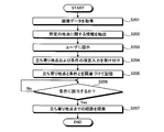
- FIG. 2 is a flowchart showing a procedure of route search processing by the route search device.
- FIG. 3 is a block diagram illustrating a hardware configuration of the navigation apparatus.
- FIG. 4 is a flowchart showing the procedure of registration processing when extraction of information on facilities and the like is started manually.
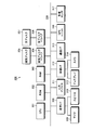
- FIG. 5 is an explanatory diagram illustrating an example of an image to be subjected to data analysis.
- FIG. 6 is a flowchart showing the procedure of the registration process when extraction of information on facilities and the like is automatically started.
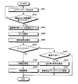
- FIG. 7 is a flowchart showing the procedure of the route search process to the registration point.
- FIG. 1 is a block diagram of a functional configuration of the route search apparatus according to the embodiment.
- the route search apparatus 100 includes an acquisition unit 101, an extraction unit 102, a presentation unit 103, an input unit 104, a storage unit 105, and a search unit 106.
- the acquisition unit 101 acquires image data.
- the image data includes moving image data and still image data.
- the acquisition unit 101 acquires, for example, broadcast data, image data recorded on a recording medium, image data shot by a user, and the like as image data.
- the extraction unit 102 extracts information about a predetermined point included in the image data.
- the information regarding the predetermined point includes the name of the point, the position (address or latitude / longitude), the telephone number, the business hours, the contents of the service to be provided such as the menu, and the like.
- the information regarding the predetermined point may be text data, image data or sound data.
- the presentation unit 103 presents information regarding a predetermined point to the user.
- the presentation unit 103 presents information on a predetermined point included in the image data, and also presents information on the predetermined point associated with the condition to the user when the condition stored in the storage unit 105 is met. Note that the presentation unit 103 may present information regarding a plurality of points to the user.
- the input unit 104 receives a designation input of a point to be a stop point among predetermined points and a condition to stop at the stop point.
- the input unit 104 accepts at least one designation as a condition to stop at the stop point, for example, any date or day of the week, when the device starts up next time, and when moving to a point other than the stop point.
- the input part 104 receives the instruction
- the storage unit 105 stores the stop point and the condition input to the input unit 104 in association with each other.
- the storage unit 105 stores feature information regarding the stop point included in the image data in association with the stop point and the condition.
- the feature information regarding the stop point is information indicating a characteristic item of the point, for example, information that is motivated to stop at the point or information with a limited period is stored as the feature information. be able to.
- the search unit 106 searches for a route to the stop point. Moreover, the search part 106 searches the path
- FIG. 2 is a flowchart showing a procedure of route search processing by the route search device.
- the route search device 100 first acquires image data by the acquisition unit 101 (step S201).
- the route search device 100 uses the extraction unit 102 to extract information about a predetermined point from the image data (step S202).
- the route search device 100 presents information related to the predetermined point to the user by the presenting unit 103 (step S203), and the input unit 104 uses the predetermined point as a stop point and a condition to stop at the point ( A designation input of a stop point and conditions is accepted (step S204). Then, the route search device 100 stores the input stop point and condition in association with the storage unit 105 (step S205).
- the route search device 100 waits until the condition specified and input in step S204 is met (step S206: No loop). If the condition is met (step S206: Yes), the search unit 106 causes the stop point to stop. The route up to this point is searched (step S207), and the processing according to this flowchart ends.
- the route search apparatus 100 stores the stop point extracted from the image data and the condition for stopping at the point in association with each other, and searches for the route to the stop point when the condition is met. Thereby, the route to the stop point extracted from the image data can be searched according to the user's needs, and the information included in the image data can be used effectively.
- the route search device 100 searches the route after making the user determine whether or not to stop at the stop point. Thereby, it is possible to meet the needs of users who may change between the time when the condition is set and the time when the route is searched.
- the route search device 100 stores the feature information regarding the stop point along with the stop point and conditions, and presents them to the user. As a result, the user can easily recall the reason for registering the stop point, and the motivation toward the stop point can be clarified.
- the route search apparatus 100 extracts a stop point from broadcast data distributed from a broadcast station, image data recorded on a recording medium, image data taken by a user, and the like. Thereby, information obtained from a wide range of media can be effectively utilized.
- the route search device 100 can set arbitrary date / time or day of the week, the next start-up of the own device, and the time of movement to a point other than the stop point as conditions for stopping at the stop point. Thereby, it is possible to search for a route to the stop point extracted from the image data in response to the detailed needs of the user.
- FIG. 3 is a block diagram illustrating a hardware configuration of the navigation apparatus.
- a navigation device 300 includes a CPU 301, ROM 302, RAM 303, magnetic disk drive 304, magnetic disk 305, optical disk drive 306, optical disk 307, audio I / F (interface) 308, microphone 309, speaker 310, input device 311, A video I / F 312, a display 313, a camera 314, a communication I / F 315, a GPS unit 316, and various sensors 317 are provided.
- Each component 301 to 317 is connected by a bus 320.
- the CPU 301 governs overall control of the navigation device 300.
- the ROM 302 records programs such as a boot program and a route search program.
- the RAM 303 is used as a work area for the CPU 301. That is, the CPU 301 controls the entire navigation device 300 by executing various programs recorded in the ROM 302 while using the RAM 303 as a work area.
- the magnetic disk drive 304 controls the reading / writing of the data with respect to the magnetic disk 305 according to control of CPU301.
- the magnetic disk 305 records data written under the control of the magnetic disk drive 304.
- an HD hard disk
- FD flexible disk
- the optical disk drive 306 controls reading / writing of data with respect to the optical disk 307 according to the control of the CPU 301.
- the optical disk 307 is a detachable recording medium from which data is read according to the control of the optical disk drive 306.
- a writable recording medium can be used as the optical disc 307.
- an MO, a memory card, or the like can be used as a removable recording medium.
- Examples of information recorded on the magnetic disk 305 and the optical disk 307 include content data and map data.
- the content data is, for example, music data, still image data, moving image data, or the like.
- the map data includes background data that represents features (features) such as buildings, rivers, and the ground surface, and road shape data that represents the shape of the road.
- the map data consists of multiple data files divided by district. It is configured.
- the voice I / F 308 is connected to a microphone 309 for voice input and a speaker 310 for voice output.
- the sound received by the microphone 309 is A / D converted in the sound I / F 308.
- the microphones 309 may be installed near the dashboard of the vehicle, and the number thereof may be one or more. From the speaker 310, a sound obtained by D / A converting a predetermined sound signal in the sound I / F 308 is output.
- the input device 311 includes a remote controller, a keyboard, a touch panel, and the like provided with a plurality of keys for inputting characters, numerical values, various instructions, and the like.
- the input device 311 may be realized by any one form of a remote control, a keyboard, and a touch panel, but may be realized by a plurality of forms.
- the video I / F 312 is connected to the display 313. Specifically, the video I / F 312 is output from, for example, a graphic controller that controls the entire display 313, a buffer memory such as a VRAM (Video RAM) that temporarily records image information that can be displayed immediately, and a graphic controller. And a control IC for controlling the display 313 based on the image data to be processed.
- a graphic controller that controls the entire display 313, a buffer memory such as a VRAM (Video RAM) that temporarily records image information that can be displayed immediately, and a graphic controller.
- VRAM Video RAM
- the camera 314 captures images inside or outside the vehicle.
- the image may be either a still image or a moving image.
- a camera 314 captures a landscape or a feature outside the vehicle, a passenger inside the vehicle, etc., and the captured image is recorded on the magnetic disk 305 or the like via the video I / F 312.
- the data is output to a recording medium such as an optical disk 307.
- a digital camera or a mobile phone owned by the user may be connected to the video I / F 312 so that the navigation device 300 can capture the digital camera or mobile phone.
- the display 313 displays icons, cursors, menus, windows, or various data such as characters and images.
- the map data described above is drawn two-dimensionally or three-dimensionally.
- the map data displayed on the display 313 can be displayed with a mark representing the current position of the vehicle on which the navigation device 300 is mounted.
- the current position of the vehicle is calculated by the CPU 301.
- a TFT liquid crystal display, an organic EL display, or the like can be used as the display 313, for example, a TFT liquid crystal display, an organic EL display, or the like can be used.
- the communication I / F 315 is wirelessly connected to a communication network such as the Internet, and also functions as an interface between the communication network and the CPU 301.
- the communication I / F 315 transmits and receives data to and from an electronic device held by a passenger by short-range communication such as infrared communication or Bluetooth (registered trademark).
- the communication I / F 315 receives broadcast waves such as television and radio. Broadcast waves received by the communication I / F 315 are output as audio information and image information to the speaker 310 and the display 313 via the audio I / F 308 and the video I / F 312.
- the GPS unit 316 receives radio waves from GPS satellites and outputs information indicating the current position of the vehicle.
- the output information of the GPS unit 316 is used when the CPU 301 calculates the current position of the vehicle together with output values of various sensors 317 described later.
- the information indicating the current position is information for specifying one point on the map data, such as latitude / longitude and altitude.
- the various sensors 317 output information for determining the position and behavior of the vehicle, such as a vehicle speed sensor, an acceleration sensor, and an angular velocity sensor.
- the output values of the various sensors 317 are used by the CPU 301 to calculate the current position of the vehicle and the amount of change in speed and direction.
- the acquisition unit 101, the extraction unit 102, the presentation unit 103, the input unit 104, the storage unit 105, and the search unit 106 of the route search device 100 illustrated in FIG. 1 are the ROM 302, the RAM 303, and the magnetic disk in the navigation device 300 illustrated in FIG.
- the CPU 301 executes a predetermined program using programs and data recorded on the optical disk 307 and the like 305, and realizes the function by controlling each unit in the navigation device 300.
- the navigation device 300 extracts facilities and travel destinations (hereinafter referred to as facilities) from content data distributed in a broadcast format, content data recorded on a recording medium such as a DVD, and image data taken by a user. Specifically, the navigation apparatus 300 performs image analysis, voice analysis, and the like on still image data, moving image data, audio data, and character information data included in the content data, and extracts information about facilities and the like.
- the information on facilities and the like is, for example, names and addresses of facilities and the like, postal codes, telephone numbers, and the like.
- the navigation device 300 allows the user to set conditions (stop conditions) to stop at the extracted facility, and register the facility as a registration point.
- stop conditions When the set stop condition is met, the registered facilities are displayed and proposed as a destination point or a stop point.
- the navigation apparatus 300 can propose a destination point on an unplanned holiday to the user, or can be guided to a facility in which the user is interested without complicated operations. . Also, by registering the features of the facilities when registering the facilities, etc., even if many facilities are registered, it is possible to easily search for facilities that meet the purpose at that time.
- FIG. 4 is a flowchart showing the procedure of registration processing when extraction of information on facilities and the like is started manually.
- the navigation device 300 outputs content data distributed in broadcast format to the user and content data recorded on a recording medium such as a DVD (step S401).
- a recording medium such as a DVD
- step S402 When the user finds an interesting facility or the like in the content (step S402: Yes), the navigation apparatus 300 shifts the content data to a position where the facility is reflected (step S403), and performs image analysis, audio analysis, and the like. Data analysis is performed (step S404). Whether or not the user finds information on the facility or the like that interests the content is determined based on, for example, whether or not a predetermined instruction is input from the user via the input device 311. Further, for example, when the output of content data is finished, the user may determine whether or not to extract facilities and the like.
- steps S403 and S404 for example, if the content data is broadcast data, the time shift function is used to shift to a position where information about the facility or the like has flowed and perform data analysis.
- the broadcast is a digital broadcast
- BML data related to the program at the shifted position is also analyzed.
- the data analysis is performed by rewinding to a position where information on the facility or the like has flowed.
- the navigation apparatus 300 displays the analysis result, that is, information on the facility obtained as a result of the analysis (step S405).
- the analysis results in addition to basic information such as the name and address of the facility, telephone number, latitude and longitude, images of facilities and dishes, the appeal point of the facility displayed on the upper right of the screen in broadcasting etc.
- the feature information is displayed.
- the information may be highlighted.
- Such period limited information is specified by extracting words such as “period” and “limited” from the content data, for example.
- the navigation device 300 causes the user to determine whether or not to immediately go to the facility to be displayed (step S406).
- step S406 Yes
- the navigation device 300 searches for a route to the facility or the like (step S407), guides the route to the facility or the like (step S408), and ends the processing according to this flowchart. . Note that after arriving at the facility, the user may determine whether to register the facility as a registration point.
- step S406 if the facility or the like is not immediately visited (step S406: No), the navigation apparatus 300 causes the user to select whether or not to register the facility or the like as a registration point (step S409).
- step S409: Yes the user is allowed to set a condition (stop condition) to stop at the facility (step S410).
- the drop-in condition may be, for example, a specific date or day of the week such as “ ⁇ month ⁇ day”, “ ⁇ during the month”, “Saturdays, Sundays, and holidays”, or a specific date such as “when starting up next time”. You don't have to.
- step S409 when “going to the next”, when a route search is performed using another point within a predetermined distance from the facility as the destination point, or when the facility is located along the route when heading to another point, You may enable it to set as a stop point. If not registered (step S409: No), the process according to this flowchart is terminated.
- step S410 the drop-in condition set in step S410 is associated with the information on the facility, etc., and registered in the registration point database (step S411), and the processing according to the present chart ends.
- the user may arbitrarily select whether or not to store the feature information of the facility and the limited time information as the information about the facility and the like. If feature information such as facilities or limited time information is stored, when the user sees a registered point at a later date, it is possible to easily recall why the point was registered.
- FIG. 5 is an explanatory diagram showing an example of an image to be subjected to data analysis.
- FIG. 5 shows a restaurant introduction image 500.
- the introductory image 500 may be, for example, distributed as broadcast data, or may be image data in which a user photographs a magazine article with a camera or the like.
- restaurant name information 501, address information 502, and telephone number information 503 are shown in the introduction image 500.
- the restaurant limited time information 504 and the menu image 505 are shown.
- the navigation device 300 extracts text information such as name information 501, address information 502, telephone number information 503, and limited time information 504 from the introduction image 500 by image analysis, and presents it to the user as information about facilities and the like.
- the name information 501, address information 502, and telephone number information 503 are stored at the time of registration as basic information of this store. Further, the menu image 505 and the limited time information 504 allow the user to determine whether or not to add it as the restaurant characteristic information at the time of registration.
- FIG. 6 is a flowchart showing the procedure of the registration process when extraction of information on facilities and the like is automatically started.
- FIG. 6 detailed description of processing whose contents overlap with those of the flowchart of FIG. 4 is omitted.
- the navigation device 300 outputs content data distributed in broadcast format to the user and content data recorded on a recording medium such as a DVD (step S601). In addition, the navigation device 300 sequentially performs data analysis such as image analysis and voice analysis on the content data to be output (step S602). This analysis result is stored in a memory or the like for a predetermined time (for example, for 10 minutes), and then erased.
- Navigation device 300 returns to step S601 and continues content output and data analysis until the user finds an interesting facility or the like in the content (step S603: No).
- the navigation device 300 displays the analysis result of the content data stored in the memory (step S604).
- the analysis results to be displayed at this time may be, for example, all the analysis results stored in the memory (in the above example, 10 minutes), or a part of the latest analysis results (for example, the latest 5 minutes) Etc.).
- the navigation device 300 causes the user to determine whether or not to immediately go to the facility to be displayed (step S605).
- step S605 Yes
- the navigation device 300 searches for a route to the facility or the like (step S606), guides the route to the facility or the like (step S607), and ends the processing according to this flowchart. . Note that after arriving at the facility, the user may determine whether to register the facility as a registration point.
- step S608 Yes
- step S609 the drop-in condition set in step S609 is associated with the information related to the facility and registered in the registration point database (step S610), and the processing according to this flowchart ends. Further, when not registering as a registration point in step S608 (step S608: No), the processing according to this flowchart is ended as it is.
- information on facilities can be extracted from images taken with digital cameras or mobile phone cameras, and registered as registration points.
- the user photographs a signboard of a facility or the like, a magazine article that introduces the facility or the like with a camera, and transfers the image data to the navigation device 300.
- the navigation device 300 analyzes the transferred image data and extracts information such as facilities.
- the subsequent processing is the same as that after step S405 in FIG.
- FIG. 7 is a flowchart showing the procedure of the route search process to the registration point.
- the navigation device 300 refers to the registration point database, and the current date and day of the week are visited. It is determined whether or not there is a facility that matches the date set as a condition (step S702). When there is a matching facility or the like (step S702: Yes), the process proceeds to step S705.
- step S702 when there is no matching facility (step S702: No), the navigation apparatus 300 allows the user to set the destination point of the route to be searched this time (step S703). Then, it is determined whether or not there is a facility or the like within the predetermined distance from the destination point set in step S703 (or located along the route toward the destination point), where the stop condition is set to “Go next”. (Step S704).
- step S704 If there is a facility etc. that is "going next" and within a predetermined distance (step S704: Yes), information about the facility stored in the registration point database is presented to the user (step S705), and whether or not to stop at the facility etc. (Step S706).
- Information related to the facility to be presented at this time is, in addition to basic information such as the name and address of the facility, telephone number, latitude / longitude, and images of facilities and dishes, for example, feature information of the facility and limited time information, etc. is there. Thereby, it becomes easy for the user to recall why the point is registered, and the motivation toward the facility or the like can be clarified.
- limited-time information is registered in a facility and the current date and time falls within that period, the information on the facility and the like may be highlighted.
- the navigation device 300 searches for a route including the facility (step S707).
- the route including the facility or the like is a route having the facility or the like as the destination (step S702: Yes pattern) or a route having the facility or the like as a stop point (step S704: Yes pattern).
- step S704 when there is no facility or the like “going next” and within a predetermined distance (step S704: No), or when it is determined in step S706 that the user does not stop at the facility (step S706: No).
- the navigation device 300 searches for a route that does not include a facility or the like registered in the registration point database (step S708). Then, the navigation device 300 performs route guidance along the route searched in step S707 or step S708 (step S709), and ends the processing according to this flowchart.
- the navigation device 300 stores the facility extracted from the content data in association with the stop condition for stopping at the facility, and searches for a route to the facility when the stop condition is met. . Thereby, a route to a facility or the like extracted from the content data can be searched according to the user's needs, and information included in the content data can be used effectively.
- the navigation device 300 searches for a route after allowing the user to determine whether or not to stop at the facility. Thereby, it is possible to meet the needs of users who may change between the time when the stop-by condition is set and the time when the route is searched.
- the navigation device 300 stores feature information related to facilities and the limited time information and presents them to the user. This makes it easy for the user to recall the reason for registering the facility, etc., and can clarify the motivation toward the facility.
- the navigation apparatus 300 extracts facilities and the like from broadcast data distributed from a broadcast station, content data recorded on a recording medium, image data taken by a user, and the like. Thereby, information obtained from a wide range of media can be effectively utilized.
- the navigation device 300 can set an arbitrary date and time or day of the week, the next start-up of the device itself and the time of movement to a point other than the facility, etc. as conditions for stopping at the facility. Thereby, it is possible to search for a route to the facility or the like extracted from the content data in response to the detailed needs of the user.
- the route search method described in the present embodiment can be realized by executing a program prepared in advance on a computer such as a personal computer or a workstation.
- This program is recorded on a computer-readable recording medium such as a hard disk, a flexible disk, a CD-ROM, an MO, and a DVD, and is executed by being read from the recording medium by the computer.
- the program may be a transmission medium that can be distributed via a network such as the Internet.
Landscapes
- Engineering & Computer Science (AREA)
- Radar, Positioning & Navigation (AREA)
- Remote Sensing (AREA)
- Physics & Mathematics (AREA)
- General Physics & Mathematics (AREA)
- Automation & Control Theory (AREA)
- Mathematical Physics (AREA)
- Navigation (AREA)
Abstract
経路探索装置(100)において、取得部(101)は、画像データを取得する。抽出部(102)は、画像データに含まれる所定の地点に関する情報を抽出する。提示部(103)は、所定の地点に関する情報をユーザに提示する。入力部(104)は、所定の地点のうち立ち寄り地点とする地点および当該立ち寄り地点に立ち寄る条件の指定入力を受け付ける。記憶部(105)は、入力部(104)に入力された立ち寄り地点と条件とを関連づけて記憶する。探索部(106)は、記憶部(105)に記憶された条件に該当する場合、立ち寄り地点までの経路を探索する。
Description
この発明は、画像データに含まれる情報から抽出した立ち寄り地点への経路を探索する経路探索装置、経路探索方法、経路探索プログラムおよび記録媒体に関する。ただし、この発明の利用は、上述した経路探索装置、経路探索方法、経路探索プログラムおよび記録媒体に限られない。
従来、放送番組の映像やユーザによって撮影された画像を解析して、地点情報を抽出するとともに、抽出された地点への経路探索をおこなう技術が知られている(たとえば、下記特許文献1~3参照)。このような技術では、たとえば、放送形式で配信された映像情報に含まれる文字に対して、文字認識処理をおこなうことによって地点特定情報を抽出し、抽出された地点特定情報に対応する特定地点を地点検索手段によって検索する。また、たとえば、放送形式で配信された音声情報に対して音声認識処理をおこなうことによって地点特定情報を抽出し、抽出された地点特定情報に対応する特定地点を地点検索手段によって検索する。このとき、文字情報に基づく文字(EPGデータ)と映像に現れた文字とを同時に出力することで、目的地情報として抽出できる文字の範囲が拡大する。
しかしながら、上記の従来技術にあっては、放送や撮影画像から抽出した地点情報は、すぐに向かう目的地点または立ち寄り地点の設定、または単なる地点登録にしか利用することができない。このため、抽出した地点情報を有効に活用することができないという問題点が一例として挙げられる。
また、上記の従来技術では、地点を登録する際に付加できる情報は、たとえば、その地点(施設)の撮影画像や商品、食事メニューの写真や図などである。このため、なぜその地点を登録したのかをユーザが忘れてしまう可能性が高く、登録した地点情報を有効に活用することができないという問題点が一例として挙げられる。
上述した課題を解決し、目的を達成するため、請求項1の発明にかかる経路探索装置は、画像データを取得する取得手段と、前記画像データに含まれる所定の地点に関する情報を抽出する抽出手段と、前記所定の地点に関する情報をユーザに提示する提示手段と、前記所定の地点のうち立ち寄り地点とする地点および当該立ち寄り地点に立ち寄る条件の指定入力を受け付ける入力手段と、前記入力手段に入力された前記立ち寄り地点と前記条件とを関連づけて記憶する記憶手段と、前記記憶手段に記憶された前記条件に該当する場合、前記立ち寄り地点までの経路を探索する探索手段と、を備えたことを特徴とする。
また、請求項8の発明にかかる経路探索方法は、画像データを取得する取得工程と、前記画像データに含まれる所定の地点に関する情報を抽出する抽出工程と、前記所定の地点に関する情報をユーザに提示する提示工程と、前記所定の地点のうち立ち寄り地点とする地点および当該立ち寄り地点に立ち寄る条件の指定入力を受け付ける入力工程と、前記入力工程で入力された前記立ち寄り地点と前記条件とを関連づけて記憶手段に記憶する記憶工程と、前記記憶手段に記憶された前記条件に該当する場合、前記立ち寄り地点までの経路を探索する探索工程と、を含んだことを特徴とする。
また、請求項9の発明にかかる経路探索プログラムは、請求項8に記載の経路探索方法をコンピュータに実行させることを特徴とする。
また、請求項10の発明にかかる記録媒体は、請求項9に記載の経路探索プログラムをコンピュータに読み取り可能な状態で記録したことを特徴とする。
100 経路探索装置
101 取得部
102 抽出部
103 提示部
104 入力部
105 記憶部
106 探索部
101 取得部
102 抽出部
103 提示部
104 入力部
105 記憶部
106 探索部
以下に添付図面を参照して、この発明に係る経路探索装置、経路探索方法、経路探索プログラムおよび記録媒体の好適な実施の形態を詳細に説明する。
(実施の形態)
図1は、実施の形態にかかる経路探索装置の機能的構成を示すブロック図である。実施の形態にかかる経路探索装置100は、取得部101、抽出部102、提示部103、入力部104、記憶部105、探索部106によって構成される。
図1は、実施の形態にかかる経路探索装置の機能的構成を示すブロック図である。実施の形態にかかる経路探索装置100は、取得部101、抽出部102、提示部103、入力部104、記憶部105、探索部106によって構成される。
取得部101は、画像データを取得する。ここで、画像データには動画像データおよび静止画像データが含まれる。取得部101は、画像データとして、たとえば放送データ、記録メディアに記録された画像データ、ユーザによって撮影された画像データなどを取得する。
抽出部102は、画像データに含まれる所定の地点に関する情報を抽出する。所定の地点に関する情報とは、地点の名称、位置(住所や緯度経度)、電話番号、営業時間、メニューなど提供するサービスの内容などである。所定の地点に関する情報は、テキストデータであってもよいし、画像データや音声データであってもよい。
提示部103は、所定の地点に関する情報をユーザに提示する。提示部103は、画像データに含まれる所定の地点に関する情報を提示する他、記憶部105に記憶されている条件に該当する場合、条件と関連づけられた所定の地点に関する情報をユーザに提示する。なお、提示部103は、複数の地点に関する情報をユーザに提示してもよい。
入力部104は、所定の地点のうち立ち寄り地点とする地点および当該立ち寄り地点に立ち寄る条件の指定入力を受け付ける。入力部104は、立ち寄り地点に立ち寄る条件として、たとえば、任意の日時または曜日、自装置の次回以降の起動時、および立ち寄り地点以外の地点への移動時のうち、少なくとも1つの指定を受け付ける。また、入力部104は、立ち寄り地点に関連づけられた条件に該当する場合、その立ち寄り地点に立ち寄るか否かの指示入力を受け付ける。なお、入力部104に立ち寄り地点として入力される地点は複数であってもよい。
記憶部105は、入力部104に入力された立ち寄り地点と条件とを関連づけて記憶する。また、記憶部105は、立ち寄り地点および条件と関連づけて、画像データに含まれる立ち寄り地点に関する特徴情報を記憶する。立ち寄り地点に関する特徴情報とは、その地点の特徴的な事項を示す情報であり、たとえば、ユーザがその地点に立ち寄ろうという動機付けとなった事項や期間が限定された情報を特徴情報として記憶することができる。
探索部106は、記憶部105に記憶された条件に該当する場合、立ち寄り地点までの経路を探索する。また、探索部106は、入力部104に立ち寄り地点に立ち寄る旨の指示入力があった場合、立ち寄り地点までの経路を探索する。
図2は、経路探索装置による経路探索処理の手順を示すフローチャートである。図2のフローチャートにおいて、経路探索装置100は、まず、取得部101によって画像データを取得する(ステップS201)。つぎに、経路探索装置100は、抽出部102によって、画像データから所定の地点に関する情報を抽出する(ステップS202)。
つづいて、経路探索装置100は、提示部103によって所定の地点に関する情報をユーザに提示し(ステップS203)、入力部104によって、所定の地点のうち立ち寄り地点とする地点およびその地点に立ち寄る条件(立ち寄り地点および条件)の指定入力を受け付ける(ステップS204)。そして、経路探索装置100は、入力された立ち寄り地点と条件とを記憶部105に関連づけて記憶する(ステップS205)。
経路探索装置100は、ステップS204で指定入力された条件に該当するまで待機して(ステップS206:Noのループ)、条件に該当する場合は(ステップS206:Yes)、探索部106によって、立ち寄り地点までの経路を探索して(ステップS207)、本フローチャートによる処理を終了する。
以上説明したように、経路探索装置100は、画像データから抽出した立ち寄り地点と、その地点に立ち寄る条件とを関連づけて記憶し、条件に該当する場合に立ち寄り地点への経路を探索する。これにより、ユーザのニーズに合わせて画像データから抽出した立ち寄り地点への経路を探索することができ、画像データに含まれる情報を有効に活用することができる。
また、経路探索装置100は、条件に該当する立ち寄り地点がある場合、立ち寄り地点に立ち寄るか否かをユーザに判断させた上で経路を探索する。これにより、条件を設定した時点から経路を探索する時点の間に変化する可能性のあるユーザのニーズに対応することができる。
また、経路探索装置100は、立ち寄り地点や条件とともに、立ち寄り地点に関する特徴情報を記憶し、ユーザに提示する。これにより、ユーザはその立ち寄り地点を登録した理由を想起しやすくなり、立ち寄り地点に向かう動機付けを明確にすることができる。
また、経路探索装置100は、放送局から配信された放送データや記録メディアに記録された画像データ、ユーザによって撮影された画像データなどから立ち寄り地点を抽出する。これにより、幅広いメディアから得られる情報を有効に活用することができる。
さらに、経路探索装置100は、立ち寄り地点に立ち寄る条件として、任意の日時または曜日、自装置の次回以降の起動時、および立ち寄り地点以外の地点への移動時などが設定可能である。これにより、ユーザの細かいニーズに対応して画像データから抽出した立ち寄り地点への経路を探索することができる。
以下に、本発明の実施例について説明する。本実施例では、車両に搭載されたナビゲーション装置300を経路探索装置100として本発明を適用した場合の一例について説明する。
(ナビゲーション装置300のハードウェア構成)
まず、ナビゲーション装置300のハードウェア構成について説明する。図3は、ナビゲーション装置のハードウェア構成を示すブロック図である。図3において、ナビゲーション装置300は、CPU301、ROM302、RAM303、磁気ディスクドライブ304、磁気ディスク305、光ディスクドライブ306、光ディスク307、音声I/F(インターフェース)308、マイク309、スピーカ310、入力デバイス311、映像I/F312、ディスプレイ313、カメラ314、通信I/F315、GPSユニット316、各種センサ317を備えている。また、各構成部301~317は、バス320によってそれぞれ接続されている。
まず、ナビゲーション装置300のハードウェア構成について説明する。図3は、ナビゲーション装置のハードウェア構成を示すブロック図である。図3において、ナビゲーション装置300は、CPU301、ROM302、RAM303、磁気ディスクドライブ304、磁気ディスク305、光ディスクドライブ306、光ディスク307、音声I/F(インターフェース)308、マイク309、スピーカ310、入力デバイス311、映像I/F312、ディスプレイ313、カメラ314、通信I/F315、GPSユニット316、各種センサ317を備えている。また、各構成部301~317は、バス320によってそれぞれ接続されている。
まず、CPU301は、ナビゲーション装置300の全体の制御を司る。ROM302は、ブートプログラム、経路探索プログラムなどのプログラムを記録している。また、RAM303は、CPU301のワークエリアとして使用される。すなわち、CPU301は、RAM303をワークエリアとして使用しながら、ROM302に記録された各種プログラムを実行することによって、ナビゲーション装置300の全体の制御を司る。
磁気ディスクドライブ304は、CPU301の制御にしたがって磁気ディスク305に対するデータの読み取り/書き込みを制御する。磁気ディスク305は、磁気ディスクドライブ304の制御で書き込まれたデータを記録する。磁気ディスク305としては、たとえば、HD(ハードディスク)やFD(フレキシブルディスク)を用いることができる。
また、光ディスクドライブ306は、CPU301の制御にしたがって光ディスク307に対するデータの読み取り/書き込みを制御する。光ディスク307は、光ディスクドライブ306の制御にしたがってデータが読み出される着脱自在な記録媒体である。光ディスク307は、書き込み可能な記録媒体を利用することもできる。着脱可能な記録媒体として、光ディスク307のほか、MO、メモリカードなどを用いることができる。
磁気ディスク305および光ディスク307に記録される情報の一例としては、コンテンツデータや地図データが挙げられる。コンテンツデータは、たとえば楽曲データや静止画データ、動画データなどである。また、地図データは、建物、河川、地表面などの地物(フィーチャ)をあらわす背景データと、道路の形状をあらわす道路形状データとを含んでおり、地区ごとに分けられた複数のデータファイルによって構成されている。
音声I/F308は、音声入力用のマイク309および音声出力用のスピーカ310に接続される。マイク309に受音された音声は、音声I/F308内でA/D変換される。マイク309は、たとえば、車両のダッシュボード付近に設置され、その数は単数でも複数でもよい。スピーカ310からは、所定の音声信号を音声I/F308内でD/A変換した音声が出力される。
入力デバイス311は、文字、数値、各種指示などの入力のための複数のキーを備えたリモコン、キーボード、タッチパネルなどが挙げられる。入力デバイス311は、リモコン、キーボード、タッチパネルのうちいずれか1つの形態によって実現されてもよいが、複数の形態によって実現することも可能である。
映像I/F312は、ディスプレイ313に接続される。映像I/F312は、具体的には、たとえば、ディスプレイ313全体を制御するグラフィックコントローラと、即時表示可能な画像情報を一時的に記録するVRAM(Video RAM)などのバッファメモリと、グラフィックコントローラから出力される画像データに基づいてディスプレイ313を制御する制御ICなどによって構成される。
カメラ314は、車両内部あるいは外部の画像を撮影する。画像は静止画像あるいは動画像のどちらでもよく、たとえば、カメラ314によって車両外部の風景や地物、車両内部の搭乗者などを撮影し、撮影した映像を映像I/F312を介して磁気ディスク305や光ディスク307などの記録媒体に出力する。また、ナビゲーション装置300に搭載されたカメラ314の他、ユーザが保有するデジタルカメラや携帯電話を映像I/F312に接続して、ナビゲーション装置300に取り込めるようにしてもよい。
ディスプレイ313には、アイコン、カーソル、メニュー、ウインドウ、あるいは文字や画像などの各種データが表示される。ディスプレイ313には、上述した地図データが、2次元または3次元に描画される。ディスプレイ313に表示された地図データには、ナビゲーション装置300を搭載した車両の現在位置をあらわすマークなどを重ねて表示することができる。車両の現在位置は、CPU301によって算出される。ディスプレイ313としては、たとえば、TFT液晶ディスプレイ、有機ELディスプレイなどを用いることができる。
通信I/F315は、無線を介してインターネットなどの通信網に接続され、この通信網とCPU301とのインターフェースとしても機能する。また、通信I/F315は赤外線通信やBluetooth(登録商標)などの近距離通信によって、搭乗者が保有する電子機器との間でデータの送受信をおこなう。また、通信I/F315は、テレビやラジオなどの放送波を受信する。通信I/F315で受信された放送波は、音声I/F308や映像I/F312を介して、スピーカ310やディスプレイ313に、音声情報や画像情報として出力される。
GPSユニット316は、GPS衛星からの電波を受信し、車両の現在位置を示す情報を出力する。GPSユニット316の出力情報は、後述する各種センサ317の出力値とともに、CPU301による車両の現在位置の算出に際して利用される。現在位置を示す情報は、たとえば緯度・経度、高度などの、地図データ上の1点を特定する情報である。
各種センサ317は、車速センサ、加速度センサ、角速度センサなどの、車両の位置や挙動を判断するための情報を出力する。各種センサ317の出力値は、CPU301による車両の現在位置の算出や、速度や方位の変化量の算出に用いられる。
図1に示した経路探索装置100の取得部101、抽出部102、提示部103、入力部104、記憶部105、探索部106は、図3に示したナビゲーション装置300におけるROM302、RAM303、磁気ディスク305、光ディスク307などに記録されたプログラムやデータを用いて、CPU301が所定のプログラムを実行し、ナビゲーション装置300における各部を制御することによってその機能を実現する。
(ナビゲーション装置300による経路探索処理)
つぎに、ナビゲーション装置300による経路探索処理について説明する。ナビゲーション装置300は、放送形式で配信されたコンテンツデータやDVDなどの記録媒体に記録されたコンテンツデータ、ユーザによって撮影された画像データなどから施設や旅行先(以下、施設等という)を抽出する。具体的には、ナビゲーション装置300は、コンテンツデータに含まれる静止画データや動画データ、音声データ、文字情報データに対して、画像解析や音声解析などをおこない、施設等に関する情報を抽出する。施設等に関する情報とは、たとえば施設等の名称や住所、郵便番号、電話番号などである。
つぎに、ナビゲーション装置300による経路探索処理について説明する。ナビゲーション装置300は、放送形式で配信されたコンテンツデータやDVDなどの記録媒体に記録されたコンテンツデータ、ユーザによって撮影された画像データなどから施設や旅行先(以下、施設等という)を抽出する。具体的には、ナビゲーション装置300は、コンテンツデータに含まれる静止画データや動画データ、音声データ、文字情報データに対して、画像解析や音声解析などをおこない、施設等に関する情報を抽出する。施設等に関する情報とは、たとえば施設等の名称や住所、郵便番号、電話番号などである。
ナビゲーション装置300は、抽出した施設等に立ち寄る条件(立ち寄り条件)をユーザに設定させ、その施設等を登録地点として登録する。そして、設定された立ち寄り条件に該当する場合に、登録された施設等を表示し、目的地点や立ち寄り地点として提案する。このようにすることで、ナビゲーション装置300は、たとえば、ユーザに対して予定のない休日における目的地点を提案したり、ユーザが興味を持った施設に煩雑な操作なしで誘導したりすることができる。また、施設等を登録する際に施設等の特徴を登録することで、多くの施設等を登録した場合であっても、そのときの目的にあった施設等を容易に検索することができる。
まず、図4~図6を用いて施設等の登録処理について説明する。図4は、施設等の情報の抽出を手動で開始する場合の登録処理の手順を示すフローチャートである。図4のフローチャートにおいて、ナビゲーション装置300は、ユーザに対して放送形式で配信されたコンテンツデータやDVDなどの記録媒体に記録されたコンテンツデータを出力している(ステップS401)。ユーザがコンテンツ内に興味を引く施設等を見つけるまでは(ステップS402:No)、ステップS401に戻り、コンテンツの出力を継続する。
ユーザがコンテンツ内に興味を引く施設等を見つけると(ステップS402:Yes)、ナビゲーション装置300はコンテンツデータを施設等が映っている位置までシフトして(ステップS403)、画像解析や音声解析などのデータ解析をおこなう(ステップS404)。ユーザがコンテンツ内に興味を引く施設等の情報を見つけたか否かは、たとえば、入力デバイス311を介して、ユーザから所定の指示入力があったか否かによって判断する。また、たとえば、コンテンツデータの出力を終了した際に、施設等の抽出をおこなうか否かをユーザに判断させてもよい。
ステップS403およびS404において、たとえば、コンテンツデータが放送データである場合は、タイムシフト機能を用いて施設等に関する情報が流れた位置へシフトしてデータ解析をおこなう。このとき、放送がデジタル放送の場合には、シフトした位置の番組に関連するBMLデータも解析する。また、たとえば、コンテンツデータがDVDなどの記録媒体に記録されている場合は、巻き戻しで施設等に関する情報が流れた位置に移動してデータ解析をおこなう。
データ解析が終了すると、ナビゲーション装置300は、解析結果、すなわち解析の結果得られた施設等に関する情報、を表示する(ステップS405)。解析結果には、施設等の名称や住所、電話番号、緯度経度、設備や料理の画像など、基本的な情報の他、たとえば、放送などにおいて画面の右上などに表示される施設のアピールポイント(特徴情報)が解析されていれば、特徴情報を表示する。特に、期間を限定した特典やイベントなどがある場合は、その情報を強調して表示してもよい。このような期間限定情報は、たとえば、コンテンツデータから「期間」「限定」などの語句を抽出することによって特定する。
そして、ナビゲーション装置300は、ユーザに対して、表示する施設等にすぐに行くか否かを判断させる(ステップS406)。すぐに行く場合(ステップS406:Yes)、ナビゲーション装置300は、施設等への経路を探索し(ステップS407)、施設等への経路誘導をおこなって(ステップS408)、本フローチャートによる処理を終了する。なお、施設等に到着後、この施設等を登録地点として登録するか否かをユーザに判断させてもよい。
一方、施設等にすぐに行かない場合(ステップS406:No)、ナビゲーション装置300は、ユーザに対して、この施設等を登録地点として登録するか否かを選択させる(ステップS409)。登録する場合は(ステップS409:Yes)、ユーザに対して、施設等に立ち寄る条件(立ち寄り条件)を設定させる(ステップS410)。立ち寄り条件とは、たとえば、「○月△日」「□月中」「土日祝日」といった具体的な日時または曜日であってもよいし、「次回以降の起動時」のように特に期日を限定しなくてもよい。また、たとえば、「ついでに行く」として、施設等から所定距離以内の他の地点を目的地点として経路探索をおこなった場合や、他の地点に向かう際の経路沿いに施設等が位置する場合に、立ち寄り地点として設定できるようにしてもよい。また、登録しない場合は(ステップS409:No)、本フローチャートによる処理を終了する。
そして、ステップS410で設定された立ち寄り条件と施設等に関する情報とを関連づけて、登録地点データベースに登録して(ステップS411)、本ローチャートによる処理を終了する。なお、ステップS411において、施設等に関する情報として、施設等の特徴情報や期間限定情報を記憶するか否かは、ユーザが任意に選択できるようにしてもよい。施設等の特徴情報や期間限定情報を記憶すれば、ユーザが後日登録地点を見た際に、なぜその地点を登録したかを想起しやすくすることができる。
図5は、データ解析の対象となる画像の一例を示す説明図である。図5には、飲食店の紹介画像500が示されている。紹介画像500は、たとえば放送データとして配信されたものであってもよいし、ユーザがカメラなどで雑誌の記事を撮影した画像データなどであってもよい。紹介画像500には、飲食店の名称情報501、住所情報502、電話番号情報503が示されている。また、この飲食店の期間限定情報504やメニュー画像505が示されている。
ナビゲーション装置300は、画像解析によって、紹介画像500から名称情報501、住所情報502、電話番号情報503、期間限定情報504などのテキスト情報を抽出し、施設等に関する情報としてユーザに提示する。そして、名称情報501、住所情報502、電話番号情報503は、この店の基本的な情報として登録時に記憶する。また、メニュー画像505および期間限定情報504は、この飲食店の特徴情報として登録時に付加するか否かをユーザに判断させる。
つぎに、施設等の情報の抽出を自動でおこなう場合の処理について説明する。図6は、施設等の情報の抽出を自動で開始する場合の登録処理の手順を示すフローチャートである。なお、図6のフローチャートにおいて、図4のフローチャートと内容が重複する処理は、詳細な説明を省略している。
ナビゲーション装置300は、ユーザに対して放送形式で配信されたコンテンツデータやDVDなどの記録媒体に記録されたコンテンツデータを出力する(ステップS601)。また、ナビゲーション装置300は、出力するコンテンツデータに対して、逐次画像解析や音声解析などのデータ解析をおこなう(ステップS602)。この解析結果は、所定時間分(たとえば、10分間分など)がメモリなどに保持され、その後は消去される。
ナビゲーション装置300は、ユーザがコンテンツ内に興味を引く施設等を見つけるまで(ステップS603:No)、ステップS601に戻り、コンテンツの出力およびデータ解析を継続する。ユーザがコンテンツ内に興味を引く施設等を見つけると(ステップS603:Yes)、ナビゲーション装置300はメモリに記憶していたコンテンツデータの解析結果を表示する(ステップS604)。このとき表示する解析結果は、たとえばメモリ内に記憶されたすべての解析結果(上記の例では10分間分)であってもよいし、直近の一部の解析結果(たとえば、直近の5分間分など)であってもよい。
そして、ナビゲーション装置300は、ユーザに対して、表示する施設等にすぐに行くか否かを判断させる(ステップS605)。すぐに行く場合(ステップS605:Yes)、ナビゲーション装置300は、施設等への経路を探索し(ステップS606)、施設等への経路誘導をおこなって(ステップS607)、本フローチャートによる処理を終了する。なお、施設等に到着後、この施設等を登録地点として登録するか否かをユーザに判断させてもよい。
一方、施設等にすぐに行かない場合(ステップS605:No)、ナビゲーション装置300は、ユーザに対して、この施設等を登録地点として登録するか否かを選択させる(ステップS608)。登録する場合は(ステップS608:Yes)、ユーザに対して立ち寄り条件を設定させる(ステップS609)。そして、ステップS609で設定された立ち寄り条件と施設等に関する情報とを関連づけて、登録地点データベースに登録して(ステップS610)、本フローチャートによる処理を終了する。また、ステップS608で登録地点として登録しない場合は(ステップS608:No)、そのまま本フローチャートによる処理を終了する。
図4のフローチャートで示したように、施設等の情報の抽出を手動で開始するようにすれば、ユーザの指示があった場合のみコンテンツデータを解析するため、ナビゲーション装置300の処理負荷を軽減することができる。また、図6のフローチャートで示したように、施設等の情報の抽出を自動で開始するようにすれば、コンテンツデータを逐次解析するため、ユーザからの指示入力に対して迅速に解析結果を表示することができる。
また、デジタルカメラや携帯電話のカメラなどで撮影した画像から施設等の情報を抽出し、登録地点として登録することもできる。この場合、ユーザは、施設等の看板や施設等を紹介した雑誌の記事などをカメラで撮影し、画像データをナビゲーション装置300に転送する。ナビゲーション装置300は、転送された画像データを解析し、施設等の情報を抽出する。その後の処理は、図4のステップS405以降と同様である。
つづいて、登録地点への経路探索処理について説明する。図7は、登録地点への経路探索処理の手順を示すフローチャートである。図7のフローチャートにおいて、たとえば停車状態にあった車両のエンジンがかけられ、ナビゲーション装置300が起動すると(ステップS701)、ナビゲーション装置300は、登録地点データベースを参照し、現在の日時や曜日が、立ち寄り条件として設定された期日と一致する施設等があるか否かを判断する(ステップS702)。一致する施設等がある場合は(ステップS702:Yes)、ステップS705に移行する。
一方、一致する施設がない場合(ステップS702:No)、ナビゲーション装置300は、今回探索する経路の目的地点をユーザに設定させる(ステップS703)。そして、立ち寄り条件が「ついでに行く」に設定され、かつステップS703で設定された目的地点から所定距離以内の(または、目的地点に向かう経路沿いに位置する)施設等があるか否かを判断する(ステップS704)。
「ついでに行く」かつ所定距離以内の施設等がある場合(ステップS704:Yes)、登録地点データベースに保存されたその施設等に関する情報をユーザに提示し(ステップS705)、その施設等に立ち寄るか否かを判断させる(ステップS706)。このとき提示する施設等に関する情報は、施設等の名称や住所、電話番号、緯度経度、設備や料理の画像など、基本的な情報の他、たとえば、施設等の特徴情報や期間限定情報などである。これにより、ユーザはなぜその地点を登録したかを想起しやすくなり、その施設等に向かう動機付けを明確にすることができる。また、施設等に期間限定情報が登録されており、かつ現在の日時がその期間に該当する場合には、その施設等の情報を強調して表示してもよい。
ユーザがその施設等に立ち寄ると判断した場合(ステップS706:Yes)、ナビゲーション装置300は、その施設等を含む経路を探索する(ステップS707)。施設等を含む経路とは、施設等を目的地点とする経路(ステップS702:Yesのパターン)、または、施設等を立ち寄り地点とする経路(ステップS704:Yesのパターン)である。
また、ステップS704で、「ついでに行く」かつ所定距離以内の施設等がない場合(ステップS704:No)、または、ステップS706でユーザがその施設等に立ち寄らないと判断した場合(ステップS706:No)、ナビゲーション装置300は、登録地点データベースに登録された施設等を含まない経路を探索する(ステップS708)。そして、ナビゲーション装置300は、ステップS707またはステップS708で探索された経路に沿って経路誘導をおこなって(ステップS709)、本フローチャートによる処理を終了する。
以上説明したように、ナビゲーション装置300は、コンテンツデータから抽出した施設等と、その施設等に立ち寄る立ち寄り条件とを関連づけて記憶し、立ち寄り条件に該当する場合にその施設等への経路を探索する。これにより、ユーザのニーズに合わせてコンテンツデータから抽出した施設等への経路を探索することができ、コンテンツデータに含まれる情報を有効に活用することができる。
また、ナビゲーション装置300は、立ち寄り条件に該当する施設等がある場合、施設等に立ち寄るか否かをユーザに判断させた上で経路を探索する。これにより、立ち寄り条件を設定した時点から経路を探索する時点の間に変化する可能性のあるユーザのニーズに対応することができる。
また、ナビゲーション装置300は、施設等に関する特徴情報や期間限定情報を記憶し、ユーザに提示する。これにより、ユーザはその施設等を登録した理由を想起しやすくなり、その施設等に向かう動機付けを明確にすることができる。
また、ナビゲーション装置300は、放送局から配信された放送データや記録メディアに記録されたコンテンツデータ、ユーザによって撮影された画像データなどから施設等を抽出する。これにより、幅広いメディアから得られる情報を有効に活用することができる。
さらに、ナビゲーション装置300は、施設等に立ち寄る条件として、任意の日時または曜日、自装置の次回以降の起動時、およびその施設等以外の地点への移動時などが設定可能である。これにより、ユーザの細かいニーズに対応してコンテンツデータから抽出した施設等への経路を探索することができる。
なお、本実施の形態で説明した経路探索方法は、あらかじめ用意されたプログラムをパーソナル・コンピュータやワークステーションなどのコンピュータで実行することにより実現することができる。このプログラムは、ハードディスク、フレキシブルディスク、CD-ROM、MO、DVDなどのコンピュータで読み取り可能な記録媒体に記録され、コンピュータによって記録媒体から読み出されることによって実行される。またこのプログラムは、インターネットなどのネットワークを介して配布することが可能な伝送媒体であってもよい。
Claims (10)
- 画像データを取得する取得手段と、
前記画像データに含まれる所定の地点に関する情報を抽出する抽出手段と、
前記所定の地点に関する情報をユーザに提示する提示手段と、
前記所定の地点のうち立ち寄り地点とする地点および当該立ち寄り地点に立ち寄る条件の指定入力を受け付ける入力手段と、
前記入力手段に入力された前記立ち寄り地点と前記条件とを関連づけて記憶する記憶手段と、
前記記憶手段に記憶された前記条件に該当する場合、前記立ち寄り地点までの経路を探索する探索手段と、
を備えたことを特徴とする経路探索装置。 - 前記提示手段は、前記条件に該当する場合、前記立ち寄り地点を前記ユーザに提示し、
前記入力手段は、前記立ち寄り地点に立ち寄るか否かの指示入力を受け付け、
前記探索手段は、前記入力手段に前記立ち寄り地点に立ち寄る旨の指示入力があった場合、前記立ち寄り地点までの経路を探索することを特徴とする請求項1に記載の経路探索装置。 - 前記記憶手段は、前記立ち寄り地点および前記条件と関連づけて、前記画像データに含まれる前記立ち寄り地点に関する特徴情報を記憶し、
前記提示手段は、前記条件に該当する場合、前記画像データに含まれる前記立ち寄り地点に関する特徴情報を前記ユーザに提示することを特徴とする請求項2に記載の経路探索装置。 - 前記取得手段は、前記画像データとして放送データを取得することを特徴とする請求項1に記載の経路探索装置。
- 前記取得手段は、前記画像データとして記録メディアに記録された画像データを取得することを特徴とする請求項1に記載の経路探索装置。
- 前記取得手段は、前記画像データとしてユーザによって撮影された画像データを取得することを特徴とする請求項1に記載の経路探索装置。
- 前記入力手段は、前記立ち寄り地点に立ち寄る前記条件として、任意の日時または曜日、自装置の次回以降の起動時、および前記立ち寄り地点以外の地点への移動時のうち、少なくとも1つの指定を受け付けることを特徴とする請求項1~6のいずれか一つに記載の経路探索装置。
- 画像データを取得する取得工程と、
前記画像データに含まれる所定の地点に関する情報を抽出する抽出工程と、
前記所定の地点に関する情報をユーザに提示する提示工程と、
前記所定の地点のうち立ち寄り地点とする地点および当該立ち寄り地点に立ち寄る条件の指定入力を受け付ける入力工程と、
前記入力工程で入力された前記立ち寄り地点と前記条件とを関連づけて記憶手段に記憶する記憶工程と、
前記記憶手段に記憶された前記条件に該当する場合、前記立ち寄り地点までの経路を探索する探索工程と、
を含んだことを特徴とする経路探索方法。 - 請求項8に記載の経路探索方法をコンピュータに実行させることを特徴とする経路探索プログラム。
- 請求項9に記載の経路探索プログラムを記録したことを特徴とするコンピュータに読み取り可能な記録媒体。
Priority Applications (1)
| Application Number | Priority Date | Filing Date | Title |
|---|---|---|---|
| PCT/JP2009/051803 WO2010089849A1 (ja) | 2009-02-03 | 2009-02-03 | 経路探索装置、経路探索方法、経路探索プログラムおよび記録媒体 |
Applications Claiming Priority (1)
| Application Number | Priority Date | Filing Date | Title |
|---|---|---|---|
| PCT/JP2009/051803 WO2010089849A1 (ja) | 2009-02-03 | 2009-02-03 | 経路探索装置、経路探索方法、経路探索プログラムおよび記録媒体 |
Publications (1)
| Publication Number | Publication Date |
|---|---|
| WO2010089849A1 true WO2010089849A1 (ja) | 2010-08-12 |
Family
ID=42541773
Family Applications (1)
| Application Number | Title | Priority Date | Filing Date |
|---|---|---|---|
| PCT/JP2009/051803 Ceased WO2010089849A1 (ja) | 2009-02-03 | 2009-02-03 | 経路探索装置、経路探索方法、経路探索プログラムおよび記録媒体 |
Country Status (1)
| Country | Link |
|---|---|
| WO (1) | WO2010089849A1 (ja) |
Cited By (1)
| Publication number | Priority date | Publication date | Assignee | Title |
|---|---|---|---|---|
| WO2018172906A1 (ja) * | 2017-03-18 | 2018-09-27 | エコエコドライブ株式会社 | 行動管理方法、行動管理装置、並びに決済補助コンピュータ |
Citations (4)
| Publication number | Priority date | Publication date | Assignee | Title |
|---|---|---|---|---|
| JP2000121376A (ja) * | 1998-10-15 | 2000-04-28 | Alpine Electronics Inc | 車載用ナビゲーション装置 |
| JP2004198158A (ja) * | 2002-12-17 | 2004-07-15 | Aisin Aw Co Ltd | 情報表示システム |
| JP2004271232A (ja) * | 2003-03-05 | 2004-09-30 | Denso Corp | ナビゲーション装置、プログラム |
| JP2005100276A (ja) * | 2003-09-26 | 2005-04-14 | Mazda Motor Corp | 情報処理システム、情報処理装置、情報処理方法及びプログラム |
-
2009
- 2009-02-03 WO PCT/JP2009/051803 patent/WO2010089849A1/ja not_active Ceased
Patent Citations (4)
| Publication number | Priority date | Publication date | Assignee | Title |
|---|---|---|---|---|
| JP2000121376A (ja) * | 1998-10-15 | 2000-04-28 | Alpine Electronics Inc | 車載用ナビゲーション装置 |
| JP2004198158A (ja) * | 2002-12-17 | 2004-07-15 | Aisin Aw Co Ltd | 情報表示システム |
| JP2004271232A (ja) * | 2003-03-05 | 2004-09-30 | Denso Corp | ナビゲーション装置、プログラム |
| JP2005100276A (ja) * | 2003-09-26 | 2005-04-14 | Mazda Motor Corp | 情報処理システム、情報処理装置、情報処理方法及びプログラム |
Cited By (1)
| Publication number | Priority date | Publication date | Assignee | Title |
|---|---|---|---|---|
| WO2018172906A1 (ja) * | 2017-03-18 | 2018-09-27 | エコエコドライブ株式会社 | 行動管理方法、行動管理装置、並びに決済補助コンピュータ |
Similar Documents
| Publication | Publication Date | Title |
|---|---|---|
| JP4812415B2 (ja) | 地図情報更新システム、中央装置、地図情報更新方法、及びコンピュータプログラム | |
| US20090171579A1 (en) | Apparatus with displaying, browsing and navigating functions for photo track log and method thereof | |
| CN101373138A (zh) | 图像再现设备及其图像再现方法和记录介质 | |
| JP2005100274A (ja) | 情報提供システム、情報検索装置及び情報提供方法 | |
| US20150134236A1 (en) | Image display system, mobile terminal, server, non-transitory physical computer-readable medium | |
| JP2005100276A (ja) | 情報処理システム、情報処理装置、情報処理方法及びプログラム | |
| JP4085634B2 (ja) | 画像表示プログラム | |
| CN103913175A (zh) | 导航系统及其兴趣地点提示方法 | |
| JP2001292389A (ja) | コンテンツ処理装置、コンテンツ処理方法及び記録媒体 | |
| JP2009025238A (ja) | 経路探索装置、ナビゲーション装置、経路探索方法、経路探索プログラムおよび記録媒体 | |
| WO2010089849A1 (ja) | 経路探索装置、経路探索方法、経路探索プログラムおよび記録媒体 | |
| JP2006064671A (ja) | 情報提供装置、及び携帯情報端末 | |
| JP2002228477A (ja) | ナビゲーション装置及びナビゲーションシステム | |
| JP2008249428A (ja) | ナビゲーション装置及びその制御方法 | |
| JP2003032590A (ja) | ナビゲーション装置を利用した映像記録システム及びナビゲーション装置 | |
| JP3147598B2 (ja) | ナビゲーション装置 | |
| JP4619442B2 (ja) | 画像表示装置、表示制御方法、表示制御プログラムおよび記録媒体 | |
| KR100950070B1 (ko) | 기행 정보 콘텐츠 제작 장치 및 방법과 콘텐츠 재생 장치 | |
| JP2005003431A (ja) | 地図情報表示装置 | |
| JP2005136604A (ja) | 電子写真アルバム作成支援装置及び方法 | |
| WO2014174648A1 (ja) | 情報記録システム、情報取得装置、情報処理方法および情報処理プログラム | |
| JP2018124293A (ja) | 情報処理装置 | |
| JP2025015591A (ja) | 情報処理装置 | |
| JP2022009101A (ja) | 情報処理装置 | |
| JP2020060594A (ja) | 情報処理装置 |
Legal Events
| Date | Code | Title | Description |
|---|---|---|---|
| 121 | Ep: the epo has been informed by wipo that ep was designated in this application |
Ref document number: 09839627 Country of ref document: EP Kind code of ref document: A1 |
|
| NENP | Non-entry into the national phase |
Ref country code: DE |
|
| 122 | Ep: pct application non-entry in european phase |
Ref document number: 09839627 Country of ref document: EP Kind code of ref document: A1 |
|
| NENP | Non-entry into the national phase |
Ref country code: JP |