US8718924B2 - Method and apparatus for road guidance using mobile terminal - Google Patents
Method and apparatus for road guidance using mobile terminal Download PDFInfo
- Publication number
- US8718924B2 US8718924B2 US12/652,461 US65246110A US8718924B2 US 8718924 B2 US8718924 B2 US 8718924B2 US 65246110 A US65246110 A US 65246110A US 8718924 B2 US8718924 B2 US 8718924B2
- Authority
- US
- United States
- Prior art keywords
- location
- designated
- user
- location information
- data
- Prior art date
- Legal status (The legal status is an assumption and is not a legal conclusion. Google has not performed a legal analysis and makes no representation as to the accuracy of the status listed.)
- Active, expires
Links
Images


Classifications
-
- H—ELECTRICITY
- H04—ELECTRIC COMMUNICATION TECHNIQUE
- H04W—WIRELESS COMMUNICATION NETWORKS
- H04W4/00—Services specially adapted for wireless communication networks; Facilities therefor
- H04W4/02—Services making use of location information
- H04W4/024—Guidance services
-
- G—PHYSICS
- G01—MEASURING; TESTING
- G01C—MEASURING DISTANCES, LEVELS OR BEARINGS; SURVEYING; NAVIGATION; GYROSCOPIC INSTRUMENTS; PHOTOGRAMMETRY OR VIDEOGRAMMETRY
- G01C21/00—Navigation; Navigational instruments not provided for in groups G01C1/00 - G01C19/00
- G01C21/26—Navigation; Navigational instruments not provided for in groups G01C1/00 - G01C19/00 specially adapted for navigation in a road network
- G01C21/34—Route searching; Route guidance
- G01C21/36—Input/output arrangements for on-board computers
- G01C21/3605—Destination input or retrieval
- G01C21/3614—Destination input or retrieval through interaction with a road map, e.g. selecting a POI icon on a road map
-
- G—PHYSICS
- G09—EDUCATION; CRYPTOGRAPHY; DISPLAY; ADVERTISING; SEALS
- G09B—EDUCATIONAL OR DEMONSTRATION APPLIANCES; APPLIANCES FOR TEACHING, OR COMMUNICATING WITH, THE BLIND, DEAF OR MUTE; MODELS; PLANETARIA; GLOBES; MAPS; DIAGRAMS
- G09B29/00—Maps; Plans; Charts; Diagrams, e.g. route diagram
- G09B29/003—Maps
-
- G—PHYSICS
- G09—EDUCATION; CRYPTOGRAPHY; DISPLAY; ADVERTISING; SEALS
- G09B—EDUCATIONAL OR DEMONSTRATION APPLIANCES; APPLIANCES FOR TEACHING, OR COMMUNICATING WITH, THE BLIND, DEAF OR MUTE; MODELS; PLANETARIA; GLOBES; MAPS; DIAGRAMS
- G09B29/00—Maps; Plans; Charts; Diagrams, e.g. route diagram
- G09B29/10—Map spot or coordinate position indicators; Map reading aids
- G09B29/106—Map spot or coordinate position indicators; Map reading aids using electronic means
-
- H—ELECTRICITY
- H04—ELECTRIC COMMUNICATION TECHNIQUE
- H04W—WIRELESS COMMUNICATION NETWORKS
- H04W4/00—Services specially adapted for wireless communication networks; Facilities therefor
- H04W4/02—Services making use of location information
- H04W4/023—Services making use of location information using mutual or relative location information between multiple location based services [LBS] targets or of distance thresholds
-
- H—ELECTRICITY
- H04—ELECTRIC COMMUNICATION TECHNIQUE
- H04W—WIRELESS COMMUNICATION NETWORKS
- H04W4/00—Services specially adapted for wireless communication networks; Facilities therefor
- H04W4/02—Services making use of location information
- H04W4/029—Location-based management or tracking services
-
- H—ELECTRICITY
- H04—ELECTRIC COMMUNICATION TECHNIQUE
- H04W—WIRELESS COMMUNICATION NETWORKS
- H04W88/00—Devices specially adapted for wireless communication networks, e.g. terminals, base stations or access point devices
- H04W88/02—Terminal devices
Definitions
- Exemplary embodiments of the present invention relate to a method and apparatus for road guidance using a mobile terminal, and more particularly, to a method for road guidance using a map created by a user and an apparatus using the method.
- Electronic devices can provide a user with the convenience of mobility and a rich is set of services and features. Examples of services including various data transmission services and additional services as well as a voice communication service using electronic device such as multimedia communication device.
- GPS Global Positioning System
- map data are used to provide the navigation service in the mobile terminal, and the mobile terminal receives information about its current location through the GPS receiver and displays a map using the map data, thereby displaying the current location to the user.
- map data that the user wants to use is typically only a portion of the map data stored in the mobile terminal, and the mobile terminal may provide the navigation service to the user by using only map data that is necessary for the user.
- the mobile terminal via a modem of a personal computer (PC) or wireless Internet to receive only the map data that is necessary and may store the map data.
- PC personal computer
- a connection of a mobile terminal to the PC to receive the map data may be required a special port for connection and to follow a complicated connection process for the user, and time and fee associated problems are typically rendered, for example, in the case of downloading the map data through the wireless Internet, a data fee may be charged to the user and downloading time may be required.
- a map provided by a map data service provider may include detailed information such as a specific road name and a name of building that may confuse the user to follow instructions.
- Exemplary embodiments of the present invention provide a method and apparatus for providing a road guidance using a map created by a user.
- Exemplary embodiments of the present invention disclose a method for providing road guidance.
- the method includes displaying a map image created by a user input.
- the method also includes setting at least one user-designated location to the map image according to the user's input.
- the method includes setting location information of the user-designated location to the user-designated location.
- the method also includes determining whether a current location information and the location information of the user-designated location is identical. And the method includes notifying of arrival at the user-designated location.
- Exemplary embodiments of the present invention disclose a terminal capable of providing road guidance.
- the terminal includes a Global Positioning System (GPS) module configured to receive a Global Positioning System (GPS) signal to set current location data.
- GPS Global Positioning System
- the terminal also includes a touch sensor unit to detect a user input and a display unit to display a map image and a user-designated location data created according to the user input.
- the terminal includes a controller to set a location data to the user-designated location data, and to create the map image.
- the terminal includes a storage unit to store the map image.
- Exemplary embodiments of the present invention disclose an apparatus using a key input unit and display unit to provide road guidance.
- the apparatus includes a processor is configured to detect a map image triggering event based on a user input.
- the processor further configured to generate location data of a user-designated location and the location data is set to the map image in response to detection of the map image triggering event created by the user input.
- the apparatus also includes a mapping table, coupled to the processor, configured to determine whether a current location data and the location data of the user-designated location is identical, wherein an arrival notice is provided.
- FIG. 1 is a diagram of a computer system that can be used to implement various exemplary embodiments, according to exemplary embodiments of the present invention.
- FIG. 2 is a flowchart of a process for creating a road guide map based on road guidance, according to exemplary embodiments of the present invention.
- FIG. 3A is a flowchart of a process for setting location information according to an input search word for creating a road guide map, according to exemplary embodiments of the present invention.
- FIG. 3B is a flowchart of a process for setting location information based on current location identification for creating a road guide map, according to exemplary embodiments of the present invention.
- FIG. 4 is a flowchart of a process for illustrating a road guidance, according to exemplary embodiments of the present invention.
- FIG. 5A is a display screen view illustrating the process for creating a road guide map of FIG. 2 , according to exemplary embodiments of the present invention.
- FIG. 5B is a display screen view illustrating the process for creating a road guide map of FIG. 2 , according to exemplary embodiments of the present invention.
- FIG. 5C is a display screen view illustrating the process for creating a road guide map of FIG. 2 , according to exemplary embodiments of the present invention.
- FIG. 5D is a display screen view illustrating location information setting menu in the process of creating a road guide map of FIG. 2 , according to exemplary embodiments of the present invention.
- FIG. 5E is a display screen view illustrating location information corresponding to an input search word from plurality of locations in the process of creating a road guide map of FIG. 2 , according to exemplary embodiments of the present invention.
- FIG. 5F is a display screen view illustrating location information corresponding to an input search word from plurality of locations in the process of creating a road guide map of FIG. 2 , according to exemplary embodiments of the present invention.
- FIG. 5G is a display screen view illustrating location information set to a location designated by the user in the process of creating a road guide map of FIG. 2 , according to exemplary embodiments of the present invention.
- FIG. 5H is a display screen view illustrating a road created according to guide is map in the process of creating a road guide map of FIG. 2 , according to exemplary embodiments of the present invention.
- FIG. 5I is a display screen view illustrating a road guide map in which an intermediate location is set in the process of creating a road guide map of FIG. 2 , according to exemplary embodiments of the present invention.
- FIG. 6A is a display screen view illustrating information associated with a current location of the mobile terminal in the process of creating a road guide map of FIG. 2 , according to exemplary embodiments of the present invention.
- FIG. 6B is a display screen view illustrating a window for inputting a name of a user-designated location in the process of creating a road guide map of FIG. 2 , according to exemplary embodiments of the present invention.
- FIG. 7A and FIG. 7B are display screen views illustrating a road guide map when the user has arrived at an intermediate location in the process of road guidance of FIG. 4 , according to exemplary embodiments of the present invention.
- FIG. 7C is a display screen view illustrating a road guide map when the user arrives at a destination in the process of road guidance of FIG. 4 , according to exemplary embodiments of the present invention.
- a “road guide map” is map data that a user can create.
- a menu for creating a map image can be included in the mobile terminal, and the user may create the map image using a touch screen or key pad.
- the mobile terminal may display, for example, a line image, and a dot image according to the user's input, and may create a map image by combining the line image and the dot image.
- the mobile terminal may display at least one user-designated location input by the user on a map image created by the user, and the user may set (e.g., affix, determine, identify or map) location information to the user-designated location.
- the mobile terminal may create a road guide map including the map image, user-designated location and location information that correspond to the user-designated location.
- a “user-designated location” is a specific location that can be set on the map image created by the user, and may include a destination and one or more intermediate locations. Location information can be set to each user-designated location in some exemplary embodiments of the present invention.
- the mobile terminal may be a terminal having a GPS module, and may be an information communication device such as a mobile communication terminal, a portable multimedia player, a personal digital assistant, a smart phone, an MPEG-1 Audio Layer III (MP) player and a multimedia device, and applications associated with terminals.
- an information communication device such as a mobile communication terminal, a portable multimedia player, a personal digital assistant, a smart phone, an MPEG-1 Audio Layer III (MP) player and a multimedia device, and applications associated with terminals.
- MP MPEG-1 Audio Layer III
- FIG. 1 is a diagram of a hardware that can be used to implement various exemplary embodiments, according to exemplary embodiments of the present invention.
- a radio frequency (RF) unit 110 may transmit and receive data signals for wireless communication of the mobile terminal.
- the RF unit 110 may include an RF transmitter configured to upconvert and to amplify signals to be transmitted, and an RF receiver is configured to gain low-noise amplified and downconverted signals. Further, the RF unit 110 may receive data signals through wireless network channels, may output the data signals to a controller 170 , and may transmit data signals transmitted from the controller 170 via wireless channels.
- a Global Positioning System (GPS) module 120 may receive GPS satellite signals from a GPS satellite.
- the GPS module 120 may include a high-frequency unit and a signal processing unit.
- the high-frequency unit may convert signals ranging from 1.2 GHz and 1.5 GHz received from an antenna into low frequency signals.
- the signal processing unit may decode spread spectrum to obtain a message and pseudo range from the satellite.
- the GPS module 120 may receive information about a current location of the mobile terminal using GPS satellite signals transmitted from the GPS satellite and may output the is location information to the controller 170 .
- execution of the instructions contained in the storage unit may cause the processor to perform processes according to the instructions.
- the controller 170 may include one or more processors in a multi-processing arrangement to execute the instructions contained in storage unit.
- Hard-wired circuitry may be used in place of, or in combination with, software instructions to implement one or more of the exemplary embodiments of the present invention.
- reconfigurable hardware such as Field Programmable Gate Arrays (FPGAs)
- FPGAs Field Programmable Gate Arrays
- functionality and connection topology of the FPGA logic gates may be customized at run-time, typically by programming memory look up tables.
- exemplary embodiments of the present invention are not limited to any specific combination of hardware circuitry and/or software.
- a “computer-readable medium” may refer to any medium that provides instructions to the processor for execution. Such a medium may be implemented in various forms, including but not limited to, non-volatile media, volatile media, and transmission media.
- Non-volatile media may include, for example, optical or magnetic disks, such as the storage device.
- Volatile media may include dynamic memory, such as main memory.
- Transmission media may include coaxial cables, copper wire and fiber optics, including the wires that comprise the bus. Transmission media can also take the form of acoustic, optical, or electromagnetic waves, such as those generated during radio frequency (RF) and infrared (IR) data communications.
- RF radio frequency
- IR infrared
- Computer-readable media include, for example, a floppy disk, a flexible disk, hard disk, magnetic tape, any other suitable magnetic medium, a compact disk read-only memory (CD-ROM), compact disc rewritable (CDRW), digital video disc (DVD), any other suitable optical medium, punch cards, optical mark sheets, any other is suitable physical medium with patterns of holes or other optically recognizable indicia, a random-access memory (RAM), a programmable read-only memory (PROM), and erasable programmable read-only memory (EPROM), a FLASH-EPROM, any other memory chip or cartridge, and a carrier wave.
- a floppy disk a flexible disk, hard disk, magnetic tape, any other suitable magnetic medium
- CD-ROM compact disk read-only memory
- CDRW compact disc rewritable
- DVD digital video disc
- any other suitable optical medium punch cards, optical mark sheets, any other is suitable physical medium with patterns of holes or other optically recognizable indicia
- RAM random-access memory
- the instructions for carrying out at least part of the present invention may be implemented on a magnetic disk of a remote computer.
- the remote mobile terminal may load the instructions into the storage unit and may send the instructions, for example, over a telephone line using a modem.
- a modem of a local system may receive the data on a telephone line and/or may be used an infrared transmitter to convert the data to an infrared signal and may transmit the infrared signal to the electronic appliance (e.g., mobile terminal).
- the electronic device may receive information and instructions provided by the infrared signal.
- the bus may provide the information and instructions to the storage unit from which a processor may retrieve and execute the instructions.
- the instructions received by storage unit may optionally be stored either before or after execution by the controller 170 .
- An audio processing unit 130 may include a codec that may include a data codec for processing packet data and an audio codec for processing audio signals.
- the audio processing unit 130 may convert, using the audio codec, digital audio signals to analog audio signals, and analog audio signals input from a microphone to digital audio signals.
- the audio processing unit 130 may also reproduce the signals generated by a speaker.
- the audio processing unit 130 may output an audible sound to indicate that the user has arrived at the location.
- a storage unit 140 may store programs and data necessary for the operation of the mobile terminal, and may include a program area and data area.
- the storage unit 140 may store a road guide map created by the user.
- the storage unit 140 may store map image data, data about user-designated locations, and data about location information corresponding to the user-designated locations as data for the road guide map.
- the storage unit 140 may store a location information list.
- the storage unit 140 may store location names and location information (e.g., latitude, longitude, and address) corresponding to the respective location names as data in the location information list. If the location information list is in a text data format, data about the location information list may require minimal capacity of the storage unit 140 , and therefore a storage medium having a large capacity may not be required.
- a touch screen 150 may include a touch sensor 152 and a display unit 154 .
- the touch sensor 152 may detect whether a touching means touches the touch screen 150 .
- the touching means may be applied by a user's hand or a touch tool, for example, a stylus pen.
- the touch sensor 152 may be an electric capacity touch detection sensor or a pressure sensor, however, it is not limited thereto and may be any sensor that may detect contact by an object or pressure thereof.
- the touch sensor 152 may be deployed at a front surface or side surface of the mobile terminal, and may operate as an input unit of the mobile terminal.
- the touch sensor 152 may detect the user's input to the touch screen 150 , may generate an input detection signal and may output the signal to the controller 170 .
- the input detection signal may include location information input by the user.
- the touch sensor 152 may detect the user's input for creating the road guide map. If the touch sensor 152 detects the user's input, it may generate a detection signal and may output the signal to the controller 170 , and the controller 170 may display a map image on the display unit 154 based on the detection signal output from the touch sensor 152 .
- the display unit 154 may include a liquid crystal display device, and may display menus, input data, function-setting information and various other information of the mobile terminal to the user. For example, the display unit 154 may output a booting screen, a standby screen, a display screen, a communication screen, or other types of application screens.
- the display unit 154 may display the road guide map created by the user by a controller 170 configured to control functions of the display unit 154 . Additionally, when a current location of the mobile terminal is within a range of the user-designated location, the display unit 154 may display an arrival notice image indicating that the user has arrived at the location.
- a key input unit 160 may receive a key operation signal from the user to control the mobile terminal and may output the signal to the controller 170 .
- the key input unit 160 may be a key pad including function keys, numeral keys and direction keys, and may be configured a side of the mobile terminal. In the case of a mobile terminal that is operable only with the touch sensor 152 , the key input unit 160 may be omitted by way of configuration. In some exemplary embodiments of the present invention, the key input unit 160 may generate signals for creating the road guide map according to the user input.
- the controller 170 may control overall operation of the mobile terminal.
- the controller 170 may control the touch sensor 152 and key input unit 160 to receive input signals and may display a map image and user-designated location on the display unit 154 . Additionally, the controller 170 may create the road guide map by setting location information to the user-designated location, and may store the created road guide map in the storage unit 140 .
- the controller 170 may control the GPS module 120 to receive information about a current location of the mobile terminal, may calculate the current location of the mobile terminal from the received current location information, and may determine whether the current location of the is mobile terminal is within a range of a user-designated location as set in the road guide map. When the current location of the mobile terminal is within a range of at least one of the user-designated location, the controller 170 may control the display unit 154 to display an arrival notice image indicating that the user has arrived at the location.
- the mobile terminal may include a vibration generation unit.
- the vibration generation unit may generate vibration by the controller 170 to control functions of the vibrations generation unit.
- the vibration generation unit may include a vibration motor that generates vibration by the rotation of an eccentric rotor. When the current location of the mobile terminal is within a range of at least one of the user-designated location, the vibration generation unit may output vibration indicating that the user has arrived at the location.
- a road guidance method according to exemplary embodiments of the present invention is described hereinafter.
- the road guidance method is described in detail with a road guide map creation process and a road guidance process.
- FIG. 2 is a flowchart of a process for creating a road guide map based on road guidance according to exemplary embodiments of the present invention.
- the controller 170 may control functions of the display unit 154 to display a road guide map creation menu.
- the user may select a menu to write a memo for creating a map, and, if the user inputs a menu selection command to write a memo, the controller 170 may control the display unit 154 to display the menu for writing a memo.
- the memo writing can be performed in a standby screen mode according to the user set-up (e.g., user settings), the controller 170 may maintain display of the standby screen of the display unit 154 while awaiting the user input.
- lower level menus may be included in the road guide map creation menu to create a new map or to edit a map stored in the storage unit.
- the user may select a lower level menu to create a new map.
- a process for creating a road guide map is described as follows.
- FIG. 5A is a display screen view illustrating the process of creating a road guide map of FIG. 2 .
- the controller 170 per step 220 , may control the display unit 154 to display a map image according to the user input.
- Drawing tools may be included in the road guide map creation menu according to exemplary embodiments of the present invention. The user may select the thickness and shape of lines using the drawing tools, and may select tools such as an eraser, and drawing functions such as painting, brushing and figure drawing.
- a menu key may be installed at a lower end of the display screen in FIG. 5A , and the user may select the drawing tools by selecting the menu key.
- FIG. 5B is a display screen view showing a map image created by the user.
- a road image can be displayed as exemplarily shown in FIG. 5B .
- the user may draw images such as a building image or a bridge image as well as a road image as the map image.
- the controller 170 may control the display unit 154 to display an image showing the user-designated location according to the user input.
- the user-designated location may correspond to a destination or an intermediate location.
- FIG. 5C is a display screen view showing a destination image as the user-designated location.
- the user can input a “Destination” key at the bottom of the display screen and then can touch an area on the map image to set a destination.
- the controller 170 may identify the touched area from a detection signal received from the touch sensor 152 , and may control the display unit 154 to display a destination image at the touched area.
- a square shaped block shown in FIG. 5C corresponds to the destination image.
- the controller 170 may set location information to the user-designated location.
- the controller 170 may promptly display a location information setting menu without displaying a destination image on the corresponding area and may set location information of the destination according to the user input.
- the controller 170 may first control the display unit 154 to display the destination image at an area to be set as the destination according to the user input, and when the user touches the destination image, the controller 170 may then control the display unit 154 to display a location information setting menu and set location information of the destination according to the user input.
- the controller 170 may control the display unit 154 to display an intermediate location image at the corresponding area. If the user touches an image in a state that both the destination image and intermediate location image are displayed, the controller 170 may control the display unit 154 to display the location information setting menu to set location information of the touched image according to the user input.
- the user may set location information corresponding to the user-designated location by searching for location information through a search word input, or may set location information by identifying a current location.
- FIG. 5D is a display screen view showing a location information setting menu. For example, two menu options of “Search Word Input” and “Current Location Identification” are shown in FIG. 5D .
- the user may set location information by using at least one menu option. Setting location information by input search word is described in detail later with reference to FIG. 3A , and setting location information by current location identification is described in detail later with reference to FIG. 3B .
- the controller 170 may create a road guide map including a map image, at least one user-designated location, and location information corresponding to the user-designated location.
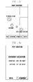
- FIG. 5H is a display screen view showing a created road guide map. “S Coffee Shop” can be displayed as a destination, and “W Bank” and “City Hall Station” can be displayed as intermediate locations. A rectangular block may be displayed at “S COFFEE SHOP” as indicating a destination image, circular blocks are displayed at “W Bank” and “City Hall Station” as indicating intermediate location images, and location information (e.g., latitude and longitude values) is set to “S Coffee Shop”, “W Bank” and “City Hall Station.”
- the controller 170 may store the road guide map created by the user in the storage unit 140 .
- the controller 170 may control the display unit 154 to display a window for inputting a name of the road guide map.
- the controller 170 processes to match the input name of the road guide map to the road guide map and to store the data in the storage unit 140 .
- Map image data, user-designated location data and location information data corresponding to the user-designated location may be stored as data for the road guide map.
- FIG. 3A is a flowchart of a process for setting location information according to a input search word for creating a road guide map, per step 240 of FIG. 2 .
- the storage unit 140 may store a preset (e.g., predetermined) location information list.
- the location information list may be created by, for example, the user input, or created from data received from a location information provider.
- the controller 170 may control the display unit 154 to display a location information search window.
- the location information search window can be displayed on the display screen shown in FIG. 5D , at the menu option “Search Word Input”.
- the user may input a search word at the location information search window using the touch screen 150 or key input unit 160 , and the controller 170 .
- a user may identify the input search word.
- the controller 170 per step 330 , may extract location information corresponding to the input search word from the location information list stored in the storage unit 140 .
- FIG. 5D the user may input “S Coffee Shop” as a search word.
- the controller 170 may extract location information of “S coffee shop” from the storage unit 140 . If location information of a plurality of “S coffee shops” is stored in the storage unit 140 , the controller 170 may control the display unit 154 to display the location information of all “S coffee shops”.
- FIG. 5E is a display screen view showing location information of a plurality of “S coffee shops”. In FIG.
- names and addresses corresponding to “S coffee shops” are enumerated, for example, “S coffee shop, Taepyeongro 1ga, Chung-gu, Seoul, Korea” and “S coffee shop, Seocho 4dong, Seocho-gu, Seoul, Korea”.
- the user may select location information of a desired “S coffee shop” from the displayed addresses of the plurality of “S coffee shops.”
- FIG. 5F is a display screen view showing location information of a plurality of “S coffee shops” as a result of a location information search, in a different form than that of FIG. 5E .
- latitude and longitude values may be displayed as well as names and addresses.
- a plurality of user-designated locations may be found within the region.
- a plurality of “S coffee shops” having the address “Taepyeongro 1ga, Chung-gu, Seoul, Korea” may exist.
- the display unit 154 may display latitude and longitude values as well as names and addresses, the user may set location information more precisely.
- the controller 170 in step 340 , may set location information extracted from the storage unit 140 to the user-designated location.
- the location information set includes a name, latitude and longitude.
- the road guide map creation process then may continue per step 250 of FIG. 2 .
- the controller 170 may create a road guide map including a map image, at least one user-designated location and location information set to the user-designated location.
- FIG. 5G is a display screen showing location information set to a location designated by the user.
- the destination image and name of “S Coffee Shop” are displayed, to which latitude and longitude information is set.
- FIG. 3B is a flowchart of a process for setting location information based on current location identification, per step, 240 of FIG. 2 .
- Location information of a current location of the mobile terminal is set to a user-designated location. For the purpose of the illustration, it is assumed that the user is presently located at the location at which the user may want to set location information before setting the location information to the user-designated location.
- the user may select “Current Location Identification” in the menu displayed on the screen of FIG. 5D , and the controller 170 , in step 315 , may operate the GPS module 120 .
- the controller 170 in step 325 , may receive information of the current location of the mobile terminal by controlling the GPS module 120 . Because the user is located in an area at which the user wants to set as location information, information about the current location of the mobile terminal can be identified by GPS signals, which corresponds to location information to be set.
- the controller 170 in step 335 , may set the location information of the current location to the user-designated location.
- FIG. 6A is a display screen view showing a current location of the mobile terminal. If the user touches a “Confirm” key shown in FIG. 6A , the controller 170 may control the display unit 154 to display a window for inputting a name of the user-designated location, as shown in FIG. 6B . When the user inputs “S Coffee Shop” and touches the confirmation key, the controller 170 may create a road guide map as shown in FIG. 5G .
- Some exemplary embodiments of the present invention may be applied in a case that location information that the user wants to set may not be stored in the storage unit 140 .
- the user may start a location information setting operation by inputting a search word.
- the controller 170 may control the display unit 154 to display a location information search window and, when the user inputs a search word into the location information search window using the touch screen 150 or key input unit 160 , the controller 170 may control the display unit 154 to display the search word.
- the controller 170 may search location information corresponding to the input search word from the location information list stored in the storage unit 140 .
- the controller 170 may control the display unit 154 to display a message that location information corresponding to the search word is not stored.
- the controller 170 may operate the GPS module 120 to receive a GPS satellite signal and may determine information of the current location of the mobile terminal by the received signal.
- the controller 170 may set the determined information of the current location of the mobile terminal to the user-designated location.
- the user may directly input latitude and longitude values to set location information which corresponds to a user-designated location.
- the user may input the latitude and longitude using units of degrees, minutes and seconds, and input units may vary according to setting of the mobile terminal.
- a name input window may be displayed as shown in FIG. 6B , and location information according to the user-designated location may be set by inputting a corresponding name.
- the controller 170 may measure a distance between user-designated locations based on location information set to the user-designated locations, and may set at least one intermediate location based on the distance between user-designated location and the intermediate location. If the distance between each of the user-designated locations is too great to measure, the user may experience difficulty in finding a road. Accordingly, the controller 170 can measure the distance between each of the user-designated locations based on location information set to the user-designated locations, and if the distance is greater than a reference distance, the controller 170 may set at least one intermediate location.
- the controller 170 may identify that the distance between “S Coffee Shop” and “W Bank” is 200 m, which is less than the reference distance 500 m, and that the distance between “W Bank” and “City Hall Station” is 1 km, which is greater than the reference distance 500 m.
- the controller 170 based on a distance scale information, may display an image representing an additional intermediate location between “W Bank” and “City Ball Station” and may set location information to the additional intermediate location.
- FIG. 5I is a display screen view showing a road guide map in which an additional intermediate location is set. In FIG. 5I , an image of an intermediate location is newly displayed between “W Bank” and “City Hall Station”.
- the controller 170 may calculate location information of the intermediate location between “W Bank” and City Hall Station” and may set the calculated location information to the intermediate location.
- FIG. 4 is a flowchart of a process for illustrating a road guidance, according to exemplary embodiments of the present invention.
- the controller 170 may receive a command input by a user to display a road guide map.
- the user may select the command to display a road guide map from a menu for a road guide function displayed on the display unit 154 .
- At least one road guide map can be stored in the storage unit 140 , and the user may display a desired road guide map using a name of the road guide map stored corresponding to the road guide map.
- the controller 170 in step 420 , may control the display unit 154 to display the requested road guide map.
- the controller 170 in step 430 , may operate the GPS module 120 .
- the controller 170 may already be operating the GPS module 120 before displaying the road guide map on the display unit 154 .
- the controller 170 may control the GPS module 120 to receive information associated with a current location of the mobile terminal.
- the controller 170 in step 450 , may determine whether the mobile terminal is located within a range of the destination using information about the current location of the mobile terminal.
- the controller 170 may compare location information of the current location of the mobile terminal received from the GPS module 120 with location information set to the user-designated location to determine whether the current location and the user-designated location are identical, and to determine whether the mobile terminal is located within a range of the user-designated location.
- the range may be a reference distance set in the mobile terminal, and may be set by the user.
- the range (e.g., distance scale) may preferably be set to a distance from the user-designated location from which the user may recognize that he has arrived at the user-designated location.
- the location information may be set as latitude and longitude values in units of degrees, minutes and seconds.
- the controller 170 may determine whether the mobile terminal is located within a range of an intermediate location. If the mobile terminal is not located within a range of an intermediate location, the process may returns to step 440 and the controller 170 may continue to receive information from the GPS module 120 about the current location of the mobile terminal. If the mobile terminal is located within a range of an intermediate location, the controller 170 , in step 470 , may control the display unit 154 to display an arrival notice image indicating that the user has arrived at the intermediate location.
- FIG. 7A and FIG. 7B are display screen views illustrating a road guide maps when the user has arrived at an intermediate location.
- FIG. 7A is a display screen view showing a road guide map when the user has arrived at the intermediate location “City Hall Station”
- FIG. 7B is a display screen view showing a road guide map when the user has arrived at the intermediate location “W Bank”.
- the controller 170 may control the display unit 154 to display the intermediate location image of “City Hall Station” or “W Bank” in a form that may be a distinguishable point from other intermediate location images, for example, by displaying the image in a large size or as a blinking image. Additionally, the controller 170 may control the display unit 154 to display the intermediate location image of “City Hall Station” or “W Bank” together with a message of “Current location” or “Here”.
- the controller 170 may control the audio processing unit 130 or vibration generation unit to output an audible signal or vibration.
- the user may identify a current location by output of the display unit 154 , audio processing unit 130 , or vibration generation unit.
- the controller 170 may control the display unit 154 to display an arrival notice image indicating that the user has arrived at the destination.
- FIG. 7C is a display screen showing a road guide map when the user has arrived at the destination “S Coffee Shop”.
- a method for indicating that the user has arrived at the destination may be the same as the method for notifying that the user has arrived at an intermediate location, and the controller 170 may operate at least one of the display unit 154 , audio processing unit 130 , and vibration generation unit (not shown) to indicate that the user has arrived at the destination.
- the controller 170 in step 490 , may terminate the operation of the GPS module 120 and the road guidance process.
- the user may arrive at a desired destination according to exemplary embodiments of the present invention without using map data provided by a map data service provider. Because only essential information for arriving at the destination is included in a road guide map created by the user, the user may easily find the destination. Additionally, because the user directly creates the road guide map, a unique user interface may be provided. The user may also upload a road guide map created by the user on a web site or send the road guide map to other users.
Landscapes
- Engineering & Computer Science (AREA)
- Physics & Mathematics (AREA)
- Theoretical Computer Science (AREA)
- General Physics & Mathematics (AREA)
- Remote Sensing (AREA)
- Radar, Positioning & Navigation (AREA)
- Business, Economics & Management (AREA)
- Educational Technology (AREA)
- Educational Administration (AREA)
- Mathematical Physics (AREA)
- Computer Networks & Wireless Communication (AREA)
- Signal Processing (AREA)
- Automation & Control Theory (AREA)
- Navigation (AREA)
- Instructional Devices (AREA)
- Traffic Control Systems (AREA)
Applications Claiming Priority (2)
| Application Number | Priority Date | Filing Date | Title |
|---|---|---|---|
| KR10-2009-0001013 | 2009-01-07 | ||
| KR1020090001013A KR101538691B1 (ko) | 2009-01-07 | 2009-01-07 | 휴대 단말기를 이용한 길 안내 방법 및 장치 |
Publications (2)
| Publication Number | Publication Date |
|---|---|
| US20100174483A1 US20100174483A1 (en) | 2010-07-08 |
| US8718924B2 true US8718924B2 (en) | 2014-05-06 |
Family
ID=42077986
Family Applications (1)
| Application Number | Title | Priority Date | Filing Date |
|---|---|---|---|
| US12/652,461 Active 2031-02-25 US8718924B2 (en) | 2009-01-07 | 2010-01-05 | Method and apparatus for road guidance using mobile terminal |
Country Status (3)
| Country | Link |
|---|---|
| US (1) | US8718924B2 (de) |
| EP (1) | EP2207014B1 (de) |
| KR (1) | KR101538691B1 (de) |
Cited By (1)
| Publication number | Priority date | Publication date | Assignee | Title |
|---|---|---|---|---|
| US12063423B1 (en) * | 2018-09-24 | 2024-08-13 | Nova Modum Inc | Enhanced interactive web features for displaying and editing digital content |
Families Citing this family (7)
| Publication number | Priority date | Publication date | Assignee | Title |
|---|---|---|---|---|
| KR101397710B1 (ko) * | 2011-02-08 | 2014-05-23 | 주식회사 팬택 | 위치 기반 데이터 제공 장치 및 방법 |
| KR20140019206A (ko) * | 2012-07-13 | 2014-02-14 | 삼성전자주식회사 | 사용자 단말에서 사용자 인터페이스 장치 및 방법 |
| US9702724B2 (en) * | 2015-06-06 | 2017-07-11 | Apple Inc. | Mapping application with transit mode |
| US10094675B2 (en) | 2015-06-07 | 2018-10-09 | Apple Inc. | Map application with transit navigation mode |
| GB202008368D0 (en) * | 2020-06-03 | 2020-07-15 | Five Ai Ltd | Systems for testing and training autonomous vehicles |
| US20220196429A1 (en) * | 2020-12-17 | 2022-06-23 | Here Global B.V. | Navigation based on a user's perception |
| WO2023239677A1 (en) * | 2022-06-05 | 2023-12-14 | Apple Inc. | Searching for stops in multistop routes |
Citations (20)
| Publication number | Priority date | Publication date | Assignee | Title |
|---|---|---|---|---|
| JPH10103988A (ja) | 1996-09-30 | 1998-04-24 | Mazda Motor Corp | ナビゲーション装置 |
| JPH11337349A (ja) | 1998-05-29 | 1999-12-10 | Nec Home Electron Ltd | ナビゲーションシステム |
| US6177905B1 (en) * | 1998-12-08 | 2001-01-23 | Avaya Technology Corp. | Location-triggered reminder for mobile user devices |
| US6320496B1 (en) * | 1999-04-29 | 2001-11-20 | Fuji Xerox Co., Ltd | Systems and methods providing tactile guidance using sensory supplementation |
| JP2002098535A (ja) | 2000-09-27 | 2002-04-05 | Kenwood Corp | ナビゲーションシステム、道路情報登録方法及び記録媒体 |
| US20040249565A1 (en) * | 2003-06-03 | 2004-12-09 | Young-Sik Park | System and method of displaying position information including and image in a navigation system |
| US6947834B2 (en) * | 2000-03-15 | 2005-09-20 | Robert Bosch Gmbh | Method for inputting a destination into a navigation device |
| US20070087828A1 (en) * | 2005-10-14 | 2007-04-19 | Alexander Robertson | Computer system for creating and playing location aware games |
| JP2007205889A (ja) | 2006-02-02 | 2007-08-16 | Xanavi Informatics Corp | ナビゲーション装置およびナビゲーション装置と通信する情報センタ |
| WO2007100632A2 (en) | 2006-02-24 | 2007-09-07 | Yahoo! Inc. | User-defined private maps |
| US20070210937A1 (en) * | 2005-04-21 | 2007-09-13 | Microsoft Corporation | Dynamic rendering of map information |
| US20080076579A1 (en) * | 2006-09-21 | 2008-03-27 | Kabushiki Kaisha Square Enix (Also Trading As Square Enix Co., Ltd.) | Video game control system and a video game control server |
| JP2008209140A (ja) | 2007-02-23 | 2008-09-11 | Denso Corp | ナビゲーション装置及びプログラム |
| US20080243374A1 (en) * | 2007-03-29 | 2008-10-02 | Mari Hatazawa | Method and apparatus for displaying house number and building footprint in arrival screen for navigation system |
| US20080313563A1 (en) * | 2007-06-14 | 2008-12-18 | Samsung Electronics Co., Ltd. | Method and apparatus for creating map template and method and apparatus for managing devices using map template |
| US20090109216A1 (en) * | 2007-10-29 | 2009-04-30 | Interman Corporation | Method and Server Computer For Generating Map Images For Creating Virtual Spaces Representing The Real World |
| US7581859B2 (en) * | 2005-09-14 | 2009-09-01 | Donnelly Corp. | Display device for exterior rearview mirror |
| US7889101B2 (en) * | 2008-04-14 | 2011-02-15 | Alpine Electronics, Inc | Method and apparatus for generating location based reminder message for navigation system |
| US7945852B1 (en) * | 2006-05-19 | 2011-05-17 | Washington State University Research Foundation | Strategies for annotating digital maps |
| US8024314B2 (en) * | 2006-03-31 | 2011-09-20 | Microsoft Corporation | Hybrid location and keyword index |
Family Cites Families (6)
| Publication number | Priority date | Publication date | Assignee | Title |
|---|---|---|---|---|
| GB9930645D0 (en) * | 1999-12-23 | 2000-02-16 | Koninkl Philips Electronics Nv | Location alarm |
| EP1355130B1 (de) * | 2002-04-17 | 2013-12-04 | Hitachi, Ltd. | Navigationssystem unter Verwendung von Telekommunikation |
| JP4314927B2 (ja) * | 2003-08-15 | 2009-08-19 | ソニー株式会社 | ナビゲーション装置 |
| JP2007065477A (ja) * | 2005-09-01 | 2007-03-15 | Nissan Motor Co Ltd | ナビゲーション装置、および地図表示方法 |
| DE602006015199D1 (de) * | 2006-10-25 | 2010-08-12 | Research In Motion Ltd | Alarmsystem für ein drahtloses Kommunikationsgerät |
| KR100876770B1 (ko) * | 2006-11-20 | 2009-01-08 | 삼성전자주식회사 | 휴대 단말기의 데이터 제어방법 |
-
2009
- 2009-01-07 KR KR1020090001013A patent/KR101538691B1/ko active Active
-
2010
- 2010-01-05 US US12/652,461 patent/US8718924B2/en active Active
- 2010-01-06 EP EP10150173.2A patent/EP2207014B1/de active Active
Patent Citations (21)
| Publication number | Priority date | Publication date | Assignee | Title |
|---|---|---|---|---|
| JPH10103988A (ja) | 1996-09-30 | 1998-04-24 | Mazda Motor Corp | ナビゲーション装置 |
| JPH11337349A (ja) | 1998-05-29 | 1999-12-10 | Nec Home Electron Ltd | ナビゲーションシステム |
| US6177905B1 (en) * | 1998-12-08 | 2001-01-23 | Avaya Technology Corp. | Location-triggered reminder for mobile user devices |
| US6320496B1 (en) * | 1999-04-29 | 2001-11-20 | Fuji Xerox Co., Ltd | Systems and methods providing tactile guidance using sensory supplementation |
| US6947834B2 (en) * | 2000-03-15 | 2005-09-20 | Robert Bosch Gmbh | Method for inputting a destination into a navigation device |
| JP2002098535A (ja) | 2000-09-27 | 2002-04-05 | Kenwood Corp | ナビゲーションシステム、道路情報登録方法及び記録媒体 |
| US20040249565A1 (en) * | 2003-06-03 | 2004-12-09 | Young-Sik Park | System and method of displaying position information including and image in a navigation system |
| US20070210937A1 (en) * | 2005-04-21 | 2007-09-13 | Microsoft Corporation | Dynamic rendering of map information |
| US7581859B2 (en) * | 2005-09-14 | 2009-09-01 | Donnelly Corp. | Display device for exterior rearview mirror |
| US20070087828A1 (en) * | 2005-10-14 | 2007-04-19 | Alexander Robertson | Computer system for creating and playing location aware games |
| JP2007205889A (ja) | 2006-02-02 | 2007-08-16 | Xanavi Informatics Corp | ナビゲーション装置およびナビゲーション装置と通信する情報センタ |
| WO2007100632A2 (en) | 2006-02-24 | 2007-09-07 | Yahoo! Inc. | User-defined private maps |
| US8024314B2 (en) * | 2006-03-31 | 2011-09-20 | Microsoft Corporation | Hybrid location and keyword index |
| US7945852B1 (en) * | 2006-05-19 | 2011-05-17 | Washington State University Research Foundation | Strategies for annotating digital maps |
| US20110214047A1 (en) * | 2006-05-19 | 2011-09-01 | Wsu Research Foundation | Strategies for annotating digital maps |
| US20080076579A1 (en) * | 2006-09-21 | 2008-03-27 | Kabushiki Kaisha Square Enix (Also Trading As Square Enix Co., Ltd.) | Video game control system and a video game control server |
| JP2008209140A (ja) | 2007-02-23 | 2008-09-11 | Denso Corp | ナビゲーション装置及びプログラム |
| US20080243374A1 (en) * | 2007-03-29 | 2008-10-02 | Mari Hatazawa | Method and apparatus for displaying house number and building footprint in arrival screen for navigation system |
| US20080313563A1 (en) * | 2007-06-14 | 2008-12-18 | Samsung Electronics Co., Ltd. | Method and apparatus for creating map template and method and apparatus for managing devices using map template |
| US20090109216A1 (en) * | 2007-10-29 | 2009-04-30 | Interman Corporation | Method and Server Computer For Generating Map Images For Creating Virtual Spaces Representing The Real World |
| US7889101B2 (en) * | 2008-04-14 | 2011-02-15 | Alpine Electronics, Inc | Method and apparatus for generating location based reminder message for navigation system |
Non-Patent Citations (5)
| Title |
|---|
| Abeshouse et al., Scavenger Hunt and Puzzle Environment, Spring 2007, Urban Nomad. * |
| European Search Report of EP 10 15 0173 dated Feb. 21, 2012. |
| Microsoft, Microsoft MapPoint FAQ, Dec. 2008 visited via Wayback Machine, www.microsoft.com/mappoint/en-us/faq.aspx. * |
| Microsoft, Microsoft MapPoint for Small Business, Dec. 2008 visited via Wayback Machine, www.microsoft.com/mappoint/en-us/SmallBiz.aspx. * |
| TOMTOM: "TomTom One", TomTom one manual, Jan. 1, 2008, pp. 1-57. |
Cited By (2)
| Publication number | Priority date | Publication date | Assignee | Title |
|---|---|---|---|---|
| US12063423B1 (en) * | 2018-09-24 | 2024-08-13 | Nova Modum Inc | Enhanced interactive web features for displaying and editing digital content |
| US20240348895A1 (en) * | 2018-09-24 | 2024-10-17 | Nova Modum Inc | Enhanced interactive web features for displaying and editing digital content |
Also Published As
| Publication number | Publication date |
|---|---|
| KR20100081671A (ko) | 2010-07-15 |
| EP2207014A3 (de) | 2012-03-21 |
| EP2207014A2 (de) | 2010-07-14 |
| US20100174483A1 (en) | 2010-07-08 |
| KR101538691B1 (ko) | 2015-07-22 |
| EP2207014B1 (de) | 2019-03-06 |
Similar Documents
| Publication | Publication Date | Title |
|---|---|---|
| US8718924B2 (en) | Method and apparatus for road guidance using mobile terminal | |
| US8700316B2 (en) | Optional re-routing | |
| EP4203526B1 (de) | Verfahren zur anzeige des aktuellen geografischen standorts auf einem notrufbildschirm und endgerät | |
| EP2685364A1 (de) | Verfahren und Vorrichtung zum Bereitstellen einer Zwischenablagefunktion in mobiler Vorrichtung | |
| KR101936605B1 (ko) | 휴대용 단말기에서 콘텐츠 태깅 방법 및 장치 | |
| US20090281724A1 (en) | Map service with network-based query for search | |
| KR20120029234A (ko) | 이동 단말기, 전자 시스템 및 이를 이용한 데이터 송수신 방법 | |
| KR20110015105A (ko) | 현재 상황에 적합한 사용 환경을 제공하는 휴대 단말기 및 이의 운용 방법 | |
| KR20110032645A (ko) | 이동 단말기의 내비게이션 방법 및 그 장치 | |
| EP2754995A1 (de) | Fahrzeugendgerät und standortbasiertes System zur gemeinsamen Inhaltsnutzung damit | |
| KR101430475B1 (ko) | 이동 단말기 및 이동 단말기의 화면 표시 방법 | |
| JP5850791B2 (ja) | 電子装置、電子処理システム、表示プログラムおよび表示方法 | |
| EP3745749A1 (de) | Audiowiedergabeverfahren und -vorrichtung | |
| US8386162B2 (en) | Electronic device and recording medium | |
| JP5124194B2 (ja) | ナビゲーション装置 | |
| CN105848105A (zh) | 一种定位信息的处理方法和装置 | |
| CN101821588A (zh) | 位置服务 | |
| CN111052050B (zh) | 一种输入信息的方法及终端 | |
| JP4894336B2 (ja) | 交差点検索装置および交差点検索方法 | |
| KR101455994B1 (ko) | 이동 단말기 및 이동 단말기의 화면 표시 방법 | |
| KR101302363B1 (ko) | 전자 기기 및 전자 기기의 제어 방법 | |
| WO2015170473A1 (ja) | アプリケーション自動制御システム、アプリケーション自動制御方法およびプログラム記録媒体 | |
| KR101729578B1 (ko) | 정보 제공 장치 및 그 방법 | |
| JP2005140570A (ja) | 施設表示制御装置 | |
| KR20110139030A (ko) | 정보 제공 장치 및 그 방법 |
Legal Events
| Date | Code | Title | Description |
|---|---|---|---|
| AS | Assignment |
Owner name: SAMSUNG ELECTRONICS CO., LTD., KOREA, REPUBLIC OF Free format text: ASSIGNMENT OF ASSIGNORS INTEREST;ASSIGNORS:KIM, HEE WOON;YOON, YEE EUN;KIM, YU RAN;AND OTHERS;REEL/FRAME:024174/0325 Effective date: 20091223 |
|
| FEPP | Fee payment procedure |
Free format text: PAYOR NUMBER ASSIGNED (ORIGINAL EVENT CODE: ASPN); ENTITY STATUS OF PATENT OWNER: LARGE ENTITY |
|
| STCF | Information on status: patent grant |
Free format text: PATENTED CASE |
|
| MAFP | Maintenance fee payment |
Free format text: PAYMENT OF MAINTENANCE FEE, 4TH YEAR, LARGE ENTITY (ORIGINAL EVENT CODE: M1551) Year of fee payment: 4 |
|
| MAFP | Maintenance fee payment |
Free format text: PAYMENT OF MAINTENANCE FEE, 8TH YEAR, LARGE ENTITY (ORIGINAL EVENT CODE: M1552); ENTITY STATUS OF PATENT OWNER: LARGE ENTITY Year of fee payment: 8 |
|
| MAFP | Maintenance fee payment |
Free format text: PAYMENT OF MAINTENANCE FEE, 12TH YEAR, LARGE ENTITY (ORIGINAL EVENT CODE: M1553); ENTITY STATUS OF PATENT OWNER: LARGE ENTITY Year of fee payment: 12 |