RU2326434C2 - Способ и система для хранения и быстрого извлечения высотных отметок цифровых моделей местности для использования в системах определения местоположения - Google Patents
Способ и система для хранения и быстрого извлечения высотных отметок цифровых моделей местности для использования в системах определения местоположения Download PDFInfo
- Publication number
- RU2326434C2 RU2326434C2 RU2004125846/09A RU2004125846A RU2326434C2 RU 2326434 C2 RU2326434 C2 RU 2326434C2 RU 2004125846/09 A RU2004125846/09 A RU 2004125846/09A RU 2004125846 A RU2004125846 A RU 2004125846A RU 2326434 C2 RU2326434 C2 RU 2326434C2
- Authority
- RU
- Russia
- Prior art keywords
- elevation
- model
- location
- compressed
- digital
- Prior art date
Links
- 238000000034 method Methods 0.000 title claims description 54
- 238000012545 processing Methods 0.000 claims description 33
- 230000009466 transformation Effects 0.000 claims description 13
- 238000004364 calculation method Methods 0.000 claims description 8
- 238000005070 sampling Methods 0.000 claims description 6
- 238000000844 transformation Methods 0.000 claims description 5
- 238000004590 computer program Methods 0.000 claims 2
- 239000000126 substance Substances 0.000 abstract 1
- 230000001413 cellular effect Effects 0.000 description 18
- 238000005259 measurement Methods 0.000 description 11
- 241000770262 Bryopsis mitochondria-associated dsRNA Species 0.000 description 5
- 238000004891 communication Methods 0.000 description 5
- 238000013459 approach Methods 0.000 description 4
- 230000006870 function Effects 0.000 description 4
- 238000006243 chemical reaction Methods 0.000 description 3
- 238000010606 normalization Methods 0.000 description 3
- 230000010267 cellular communication Effects 0.000 description 2
- 230000006835 compression Effects 0.000 description 2
- 238000007906 compression Methods 0.000 description 2
- 238000011439 discrete element method Methods 0.000 description 2
- 238000012423 maintenance Methods 0.000 description 2
- 230000009467 reduction Effects 0.000 description 2
- 230000004044 response Effects 0.000 description 2
- 239000000969 carrier Substances 0.000 description 1
- 238000005266 casting Methods 0.000 description 1
- 238000013499 data model Methods 0.000 description 1
- 230000001934 delay Effects 0.000 description 1
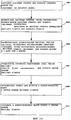
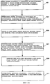
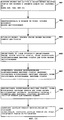
- 238000010586 diagram Methods 0.000 description 1
- 208000016570 early-onset generalized limb-onset dystonia Diseases 0.000 description 1
- 230000014509 gene expression Effects 0.000 description 1
- 230000003993 interaction Effects 0.000 description 1
- 230000001360 synchronised effect Effects 0.000 description 1
Images
Classifications
-
- G—PHYSICS
- G01—MEASURING; TESTING
- G01S—RADIO DIRECTION-FINDING; RADIO NAVIGATION; DETERMINING DISTANCE OR VELOCITY BY USE OF RADIO WAVES; LOCATING OR PRESENCE-DETECTING BY USE OF THE REFLECTION OR RERADIATION OF RADIO WAVES; ANALOGOUS ARRANGEMENTS USING OTHER WAVES
- G01S5/00—Position-fixing by co-ordinating two or more direction or position line determinations; Position-fixing by co-ordinating two or more distance determinations
- G01S5/02—Position-fixing by co-ordinating two or more direction or position line determinations; Position-fixing by co-ordinating two or more distance determinations using radio waves
- G01S5/0205—Details
- G01S5/0236—Assistance data, e.g. base station almanac
-
- G—PHYSICS
- G01—MEASURING; TESTING
- G01C—MEASURING DISTANCES, LEVELS OR BEARINGS; SURVEYING; NAVIGATION; GYROSCOPIC INSTRUMENTS; PHOTOGRAMMETRY OR VIDEOGRAMMETRY
- G01C21/00—Navigation; Navigational instruments not provided for in groups G01C1/00 - G01C19/00
- G01C21/005—Navigation; Navigational instruments not provided for in groups G01C1/00 - G01C19/00 with correlation of navigation data from several sources, e.g. map or contour matching
-
- G—PHYSICS
- G01—MEASURING; TESTING
- G01C—MEASURING DISTANCES, LEVELS OR BEARINGS; SURVEYING; NAVIGATION; GYROSCOPIC INSTRUMENTS; PHOTOGRAMMETRY OR VIDEOGRAMMETRY
- G01C21/00—Navigation; Navigational instruments not provided for in groups G01C1/00 - G01C19/00
- G01C21/20—Instruments for performing navigational calculations
-
- G—PHYSICS
- G01—MEASURING; TESTING
- G01S—RADIO DIRECTION-FINDING; RADIO NAVIGATION; DETERMINING DISTANCE OR VELOCITY BY USE OF RADIO WAVES; LOCATING OR PRESENCE-DETECTING BY USE OF THE REFLECTION OR RERADIATION OF RADIO WAVES; ANALOGOUS ARRANGEMENTS USING OTHER WAVES
- G01S19/00—Satellite radio beacon positioning systems; Determining position, velocity or attitude using signals transmitted by such systems
- G01S19/38—Determining a navigation solution using signals transmitted by a satellite radio beacon positioning system
- G01S19/39—Determining a navigation solution using signals transmitted by a satellite radio beacon positioning system the satellite radio beacon positioning system transmitting time-stamped messages, e.g. GPS [Global Positioning System], GLONASS [Global Orbiting Navigation Satellite System] or GALILEO
- G01S19/42—Determining position
- G01S19/50—Determining position whereby the position solution is constrained to lie upon a particular curve or surface, e.g. for locomotives on railway tracks
-
- G—PHYSICS
- G01—MEASURING; TESTING
- G01S—RADIO DIRECTION-FINDING; RADIO NAVIGATION; DETERMINING DISTANCE OR VELOCITY BY USE OF RADIO WAVES; LOCATING OR PRESENCE-DETECTING BY USE OF THE REFLECTION OR RERADIATION OF RADIO WAVES; ANALOGOUS ARRANGEMENTS USING OTHER WAVES
- G01S5/00—Position-fixing by co-ordinating two or more direction or position line determinations; Position-fixing by co-ordinating two or more distance determinations
- G01S5/02—Position-fixing by co-ordinating two or more direction or position line determinations; Position-fixing by co-ordinating two or more distance determinations using radio waves
- G01S5/0257—Hybrid positioning
- G01S5/0268—Hybrid positioning by deriving positions from different combinations of signals or of estimated positions in a single positioning system
-
- H—ELECTRICITY
- H03—ELECTRONIC CIRCUITRY
- H03M—CODING; DECODING; CODE CONVERSION IN GENERAL
- H03M7/00—Conversion of a code where information is represented by a given sequence or number of digits to a code where the same, similar or subset of information is represented by a different sequence or number of digits
- H03M7/30—Compression; Expansion; Suppression of unnecessary data, e.g. redundancy reduction
-
- H—ELECTRICITY
- H04—ELECTRIC COMMUNICATION TECHNIQUE
- H04W—WIRELESS COMMUNICATION NETWORKS
- H04W64/00—Locating users or terminals or network equipment for network management purposes, e.g. mobility management
-
- G—PHYSICS
- G01—MEASURING; TESTING
- G01S—RADIO DIRECTION-FINDING; RADIO NAVIGATION; DETERMINING DISTANCE OR VELOCITY BY USE OF RADIO WAVES; LOCATING OR PRESENCE-DETECTING BY USE OF THE REFLECTION OR RERADIATION OF RADIO WAVES; ANALOGOUS ARRANGEMENTS USING OTHER WAVES
- G01S19/00—Satellite radio beacon positioning systems; Determining position, velocity or attitude using signals transmitted by such systems
- G01S19/01—Satellite radio beacon positioning systems transmitting time-stamped messages, e.g. GPS [Global Positioning System], GLONASS [Global Orbiting Navigation Satellite System] or GALILEO
- G01S19/03—Cooperating elements; Interaction or communication between different cooperating elements or between cooperating elements and receivers
- G01S19/05—Cooperating elements; Interaction or communication between different cooperating elements or between cooperating elements and receivers providing aiding data
- G01S19/06—Cooperating elements; Interaction or communication between different cooperating elements or between cooperating elements and receivers providing aiding data employing an initial estimate of the location of the receiver as aiding data or in generating aiding data
Landscapes
- Engineering & Computer Science (AREA)
- Radar, Positioning & Navigation (AREA)
- Remote Sensing (AREA)
- Physics & Mathematics (AREA)
- General Physics & Mathematics (AREA)
- Automation & Control Theory (AREA)
- Computer Networks & Wireless Communication (AREA)
- Signal Processing (AREA)
- Theoretical Computer Science (AREA)
- Position Fixing By Use Of Radio Waves (AREA)
- Radar Systems Or Details Thereof (AREA)
- Processing Or Creating Images (AREA)
- Control Of Position, Course, Altitude, Or Attitude Of Moving Bodies (AREA)
- Aiming, Guidance, Guns With A Light Source, Armor, Camouflage, And Targets (AREA)
- Instructional Devices (AREA)
- Mobile Radio Communication Systems (AREA)
- Compression, Expansion, Code Conversion, And Decoders (AREA)
- Information Retrieval, Db Structures And Fs Structures Therefor (AREA)
- Signal Processing For Digital Recording And Reproducing (AREA)
Applications Claiming Priority (2)
| Application Number | Priority Date | Filing Date | Title |
|---|---|---|---|
| US10/057,189 US6985903B2 (en) | 2002-01-25 | 2002-01-25 | Method and system for storage and fast retrieval of digital terrain model elevations for use in positioning systems |
| US10/057,189 | 2002-01-25 |
Publications (2)
| Publication Number | Publication Date |
|---|---|
| RU2004125846A RU2004125846A (ru) | 2006-01-27 |
| RU2326434C2 true RU2326434C2 (ru) | 2008-06-10 |
Family
ID=27609393
Family Applications (1)
| Application Number | Title | Priority Date | Filing Date |
|---|---|---|---|
| RU2004125846/09A RU2326434C2 (ru) | 2002-01-25 | 2003-01-24 | Способ и система для хранения и быстрого извлечения высотных отметок цифровых моделей местности для использования в системах определения местоположения |
Country Status (11)
Cited By (5)
| Publication number | Priority date | Publication date | Assignee | Title |
|---|---|---|---|---|
| RU2534739C2 (ru) * | 2009-02-05 | 2014-12-10 | Эппл Инк | Способ и система беспроводной радиосвязи и способ пакетной передачи |
| RU2549127C2 (ru) * | 2010-11-30 | 2015-04-20 | Хэллибертон Энерджи Сервисиз, Инк. | Оценивание поверхностных данных |
| RU2644996C2 (ru) * | 2016-06-01 | 2018-02-15 | Федеральное государственное бюджетное военное образовательное учреждение высшего образования "Военно-космическая академия имени А.Ф. Можайского" Министерства обороны Российской Федерации | Способ оценки точности геометрической модели местности при ее автоматическом построении |
| RU2668730C1 (ru) * | 2017-11-01 | 2018-10-02 | Федеральное государственное бюджетное образовательное учреждение высшего образования "Сибирский государственный университет геосистем и технологий" | Способ получения, обработки, отображения и интерпретации геопространственных данных для геодезического мониторинга деформационного состояния инженерного объекта |
| WO2019066686A1 (ru) * | 2017-09-28 | 2019-04-04 | Общество с ограниченной ответственностью "НЕОСФЕРА" | Способ сбора данных и система для осуществления указанного способа |
Families Citing this family (54)
| Publication number | Priority date | Publication date | Assignee | Title |
|---|---|---|---|---|
| US7038694B1 (en) * | 2002-03-11 | 2006-05-02 | Microsoft Corporation | Automatic scenery object generation |
| US7068819B1 (en) * | 2002-07-12 | 2006-06-27 | The United States Of America As Represented By The Secretary Of The Navy | System for storing geospecific data |
| US7233798B2 (en) * | 2002-09-30 | 2007-06-19 | Motorola, Inc. | Method and apparatus for determining location of a remote unit using GPS |
| WO2005060669A2 (en) * | 2003-12-19 | 2005-07-07 | Kennedy Joseph P | E-otd augmentation to u-tdoa location system |
| US8587664B2 (en) * | 2004-02-02 | 2013-11-19 | Rochester Institute Of Technology | Target identification and location system and a method thereof |
| US7761455B2 (en) * | 2004-03-31 | 2010-07-20 | Hewlett-Packard Development Company, L.P. | Loading data from a vertical database table into a horizontal database table |
| US7680350B2 (en) * | 2004-05-07 | 2010-03-16 | TerraMetrics, Inc. | Method and system for progressive mesh storage and reconstruction using wavelet-encoded height fields |
| US20050288858A1 (en) * | 2004-06-29 | 2005-12-29 | Amer Osama A | Mecca finder |
| KR20060051812A (ko) * | 2004-09-29 | 2006-05-19 | 후지 샤신 필름 가부시기가이샤 | 런 렝스 압축 데이터의 위치 특정 방법 및 장치 |
| US7864175B2 (en) * | 2006-03-09 | 2011-01-04 | Ambercore Software Inc | Fast gridding of irregular data |
| US7739032B2 (en) * | 2006-03-21 | 2010-06-15 | Broadcom Corporation | Method and apparatus for generating and using a regional-terrain model |
| US7912296B1 (en) | 2006-05-02 | 2011-03-22 | Google Inc. | Coverage mask generation for large images |
| US7965902B1 (en) | 2006-05-19 | 2011-06-21 | Google Inc. | Large-scale image processing using mass parallelization techniques |
| US8762493B1 (en) | 2006-06-22 | 2014-06-24 | Google Inc. | Hierarchical spatial data structure and 3D index data versioning for generating packet data |
| JP4910675B2 (ja) * | 2006-12-15 | 2012-04-04 | セイコーエプソン株式会社 | 測位回路、電子機器、測位方法及びプログラム |
| US7650240B2 (en) * | 2007-06-22 | 2010-01-19 | Weyerhaeuser Nr Company | Estimating an attribute value using spatial interpolation and masking zones |
| US8700322B2 (en) * | 2008-02-20 | 2014-04-15 | Qualcomm Incorporated | Efficient use of expected user altitude data to aid in determining a position of a mobile station |
| US8872847B2 (en) | 2008-08-28 | 2014-10-28 | Google Inc. | Architectures and methods for creating and representing time-dependent imagery |
| US8077918B2 (en) * | 2008-08-28 | 2011-12-13 | Google, Inc. | Architectures and methods for creating and representing time-dependent imagery |
| US8630804B2 (en) * | 2008-12-05 | 2014-01-14 | Thales | Method for geolocating an object by multitelemetry |
| IL202062A0 (en) | 2009-11-11 | 2010-11-30 | Dror Nadam | Apparatus, system and method for self orientation |
| US8224516B2 (en) * | 2009-12-17 | 2012-07-17 | Deere & Company | System and method for area coverage using sector decomposition |
| US20110153338A1 (en) * | 2009-12-17 | 2011-06-23 | Noel Wayne Anderson | System and method for deploying portable landmarks |
| US8635015B2 (en) * | 2009-12-17 | 2014-01-21 | Deere & Company | Enhanced visual landmark for localization |
| US8799292B2 (en) * | 2010-03-03 | 2014-08-05 | Cellguide Ltd. | Method of generating an elevation database |
| EP2550546A4 (en) * | 2010-03-25 | 2013-09-04 | Cellguide Ltd | GNSS NAVIGATION FACILITATED BY STATIC DATA |
| WO2011154769A1 (en) * | 2010-06-07 | 2011-12-15 | Nokia Corporation | Handling data with limited applicability area |
| DE102010063336B4 (de) * | 2010-12-17 | 2023-08-24 | Bayerische Motoren Werke Aktiengesellschaft | Verfahren zur Erzeugung von standarisierten Navigationsdaten |
| US20140081611A1 (en) * | 2011-02-28 | 2014-03-20 | Leica Geosystems Ag | Integrated terrain modelling system |
| EP2518443B1 (en) * | 2011-04-29 | 2016-06-08 | Harman Becker Automotive Systems GmbH | Method of generating a database, navigation device and method of determining height information |
| CA2847222C (en) * | 2011-09-23 | 2020-07-21 | Rx Networks Inc. | Geo-reference based positioning of a mobile device |
| EP2574962A3 (en) * | 2011-09-30 | 2015-05-20 | Maishi Electronic (Shanghai) Ltd. | A moving information determination apparatus, a receiver, and a method thereby |
| CN103033822B (zh) * | 2011-09-30 | 2014-09-24 | 迈实电子(上海)有限公司 | 移动信息确定装置、方法以及接收机 |
| US9297881B2 (en) * | 2011-11-14 | 2016-03-29 | Microsoft Technology Licensing, Llc | Device positioning via device-sensed data evaluation |
| EP2826149A1 (en) | 2012-03-15 | 2015-01-21 | Nokia Corporation | Encoding and decoding of data |
| US9360559B2 (en) | 2012-03-21 | 2016-06-07 | Apple Inc. | GNSS navigation solution using inequality constraints |
| US9189573B2 (en) * | 2012-06-06 | 2015-11-17 | Google Inc. | Methods and systems to synthesize terrain elevations under overpasses |
| US20140254888A1 (en) * | 2013-03-07 | 2014-09-11 | Qualcomm Incorporated | Method and apparatus for encoding assistance data in location technologies |
| US9972121B2 (en) | 2014-04-22 | 2018-05-15 | Google Llc | Selecting time-distributed panoramic images for display |
| US9934222B2 (en) | 2014-04-22 | 2018-04-03 | Google Llc | Providing a thumbnail image that follows a main image |
| USD781317S1 (en) | 2014-04-22 | 2017-03-14 | Google Inc. | Display screen with graphical user interface or portion thereof |
| USD781318S1 (en) | 2014-04-22 | 2017-03-14 | Google Inc. | Display screen with graphical user interface or portion thereof |
| USD780777S1 (en) | 2014-04-22 | 2017-03-07 | Google Inc. | Display screen with graphical user interface or portion thereof |
| GB2548852B (en) | 2016-03-30 | 2020-10-28 | Advanced Risc Mach Ltd | Method of operating a graphics processing pipeline by compressing a block of sampling positions having the same data value |
| WO2018126067A1 (en) | 2016-12-30 | 2018-07-05 | DeepMap Inc. | Vector data encoding of high definition map data for autonomous vehicles |
| US10529049B2 (en) * | 2017-03-27 | 2020-01-07 | Oracle International Corporation | Efficient parallel algorithm for integral image computation for many-core CPUs |
| US10482655B2 (en) * | 2017-11-20 | 2019-11-19 | Here Global B.V. | Method and apparatus for providing a tile-based digital elevation model |
| US11480646B2 (en) | 2018-02-21 | 2022-10-25 | Telefonaktiebolaget Lm Ericsson (Publ) | Signaling of scaled 3D position information |
| US11486959B2 (en) | 2018-02-21 | 2022-11-01 | Telefonaktiebolaget Lm Ericsson (Publ) | Scaled TDOA 3D positioning |
| CN110716997B (zh) * | 2019-04-24 | 2022-02-08 | 中国科学院地理科学与资源研究所 | 一种目标地址坡度数据获取方法及装置 |
| CN111275757B (zh) * | 2020-01-08 | 2023-04-07 | 中国电子科技集团公司第五十四研究所 | 一种基于dem数据处理的伪卫星场地仿真布设方法 |
| CN111366172B (zh) * | 2020-03-18 | 2022-03-11 | 中国石油工程建设有限公司华北分公司 | 数字高程模型的质量检测方法、装置和存储介质 |
| JP2022108002A (ja) * | 2021-01-12 | 2022-07-25 | 本田技研工業株式会社 | データ圧縮方法、データ圧縮プログラム、及び、データ圧縮装置 |
| CN114596415B (zh) * | 2022-03-03 | 2024-08-23 | 广东汇天航空航天科技有限公司 | 地形数据处理方法、装置、设备及存储介质 |
Citations (4)
| Publication number | Priority date | Publication date | Assignee | Title |
|---|---|---|---|---|
| RU2077800C1 (ru) * | 1994-04-14 | 1997-04-20 | Акционерное общество закрытого типа "СП Параграф" | Способ картографического отображения современной блоковой структуры земной коры |
| US5902347A (en) * | 1996-11-19 | 1999-05-11 | American Navigation Systems, Inc. | Hand-held GPS-mapping device |
| US6023278A (en) * | 1995-10-16 | 2000-02-08 | Margolin; Jed | Digital map generator and display system |
| US6161148A (en) * | 1996-09-27 | 2000-12-12 | Kodak Limited | Computer method and apparatus for interactive objects controls |
Family Cites Families (17)
| Publication number | Priority date | Publication date | Assignee | Title |
|---|---|---|---|---|
| FR2666472B1 (fr) | 1990-08-31 | 1992-10-16 | Alcatel Nv | Systeme de memorisation temporaire d'information comprenant une memoire tampon enregistrant des donnees en blocs de donnees de longueur fixe ou variable. |
| US5264848A (en) * | 1992-01-14 | 1993-11-23 | Honeywell Inc. | Data compression/decompression with aliasing error reduction |
| JPH08285932A (ja) * | 1995-04-18 | 1996-11-01 | Matsushita Electric Ind Co Ltd | Gps受信装置 |
| US5841396A (en) * | 1996-03-08 | 1998-11-24 | Snaptrack, Inc. | GPS receiver utilizing a communication link |
| US5945944A (en) * | 1996-03-08 | 1999-08-31 | Snaptrack, Inc. | Method and apparatus for determining time for GPS receivers |
| US5839088A (en) * | 1996-08-22 | 1998-11-17 | Go2 Software, Inc. | Geographic location referencing system and method |
| US5968109A (en) * | 1996-10-25 | 1999-10-19 | Navigation Technologies Corporation | System and method for use and storage of geographic data on physical media |
| US5812087A (en) * | 1997-02-03 | 1998-09-22 | Snaptrack, Inc. | Method and apparatus for satellite positioning system based time measurement |
| US6215442B1 (en) | 1997-02-03 | 2001-04-10 | Snaptrack, Inc. | Method and apparatus for determining time in a satellite positioning system |
| US6229546B1 (en) * | 1997-09-09 | 2001-05-08 | Geosoftware, Inc. | Rapid terrain model generation with 3-D object features and user customization interface |
| US6061018A (en) * | 1998-05-05 | 2000-05-09 | Snaptrack, Inc. | Method and system for using altitude information in a satellite positioning system |
| US20040075738A1 (en) * | 1999-05-12 | 2004-04-22 | Sean Burke | Spherical surveillance system architecture |
| US6317690B1 (en) * | 1999-06-28 | 2001-11-13 | Min-Chung Gia | Path planning, terrain avoidance and situation awareness system for general aviation |
| JP3649430B2 (ja) * | 1999-06-30 | 2005-05-18 | 日立ソフトウエアエンジニアリング株式会社 | 図形データ管理方法およびシステム、記憶媒体 |
| DE10010436A1 (de) * | 2000-03-03 | 2001-09-06 | Bosch Gmbh Robert | Verfahren zur Übertragung von ortsbezogenen Dateninformationen zwischen einer Zentrale und einem mobilen Endgerät, mobiles Endgerät und Zentrale |
| US6757445B1 (en) * | 2000-10-04 | 2004-06-29 | Pixxures, Inc. | Method and apparatus for producing digital orthophotos using sparse stereo configurations and external models |
| US20020188669A1 (en) * | 2001-06-11 | 2002-12-12 | Levine Marc Jay | Integrated method for disseminating large spatial data sets in a distributed form via the internet |
-
2002
- 2002-01-25 US US10/057,189 patent/US6985903B2/en not_active Expired - Lifetime
-
2003
- 2003-01-24 JP JP2003564775A patent/JP4938220B2/ja not_active Expired - Lifetime
- 2003-01-24 DE DE60306370T patent/DE60306370T2/de not_active Expired - Lifetime
- 2003-01-24 AU AU2003210653A patent/AU2003210653A1/en not_active Abandoned
- 2003-01-24 DE DE60318499T patent/DE60318499T2/de not_active Expired - Lifetime
- 2003-01-24 WO PCT/US2003/002223 patent/WO2003065253A2/en active IP Right Grant
- 2003-01-24 BR BRPI0307100-6A patent/BR0307100A/pt not_active IP Right Cessation
- 2003-01-24 EP EP03734997A patent/EP1506687B1/en not_active Expired - Lifetime
- 2003-01-24 RU RU2004125846/09A patent/RU2326434C2/ru not_active IP Right Cessation
- 2003-01-24 AT AT06004083T patent/ATE383051T1/de not_active IP Right Cessation
- 2003-01-24 AT AT03734997T patent/ATE331411T1/de not_active IP Right Cessation
- 2003-01-24 CA CA002474093A patent/CA2474093A1/en not_active Abandoned
- 2003-01-24 ES ES06004083T patent/ES2297776T3/es not_active Expired - Lifetime
- 2003-01-24 EP EP06004083A patent/EP1662837B1/en not_active Expired - Lifetime
- 2003-01-24 ES ES03734997T patent/ES2266826T3/es not_active Expired - Lifetime
-
2005
- 2005-06-01 US US11/143,350 patent/US7664764B2/en not_active Expired - Lifetime
-
2010
- 2010-01-29 JP JP2010019143A patent/JP2010122236A/ja not_active Withdrawn
Patent Citations (4)
| Publication number | Priority date | Publication date | Assignee | Title |
|---|---|---|---|---|
| RU2077800C1 (ru) * | 1994-04-14 | 1997-04-20 | Акционерное общество закрытого типа "СП Параграф" | Способ картографического отображения современной блоковой структуры земной коры |
| US6023278A (en) * | 1995-10-16 | 2000-02-08 | Margolin; Jed | Digital map generator and display system |
| US6161148A (en) * | 1996-09-27 | 2000-12-12 | Kodak Limited | Computer method and apparatus for interactive objects controls |
| US5902347A (en) * | 1996-11-19 | 1999-05-11 | American Navigation Systems, Inc. | Hand-held GPS-mapping device |
Cited By (10)
| Publication number | Priority date | Publication date | Assignee | Title |
|---|---|---|---|---|
| RU2534739C2 (ru) * | 2009-02-05 | 2014-12-10 | Эппл Инк | Способ и система беспроводной радиосвязи и способ пакетной передачи |
| US9423488B2 (en) | 2009-02-05 | 2016-08-23 | Apple Inc. | Method and system for user equipment location determination on a wireless transmission system |
| US9739869B2 (en) | 2009-02-05 | 2017-08-22 | Apple Inc. | Method and system for user equipment location determination on a wireless transmission system |
| US10082558B2 (en) | 2009-02-05 | 2018-09-25 | Apple Inc. | Method and system for user equipment location determination on a wireless transmission system |
| US10330771B2 (en) | 2009-02-05 | 2019-06-25 | Apple Inc. | Method and system for user equipment location determination on a wireless transmission system |
| US10901067B2 (en) | 2009-02-05 | 2021-01-26 | Apple Inc. | Method and system for user equipment location determination on a wireless transmission system |
| RU2549127C2 (ru) * | 2010-11-30 | 2015-04-20 | Хэллибертон Энерджи Сервисиз, Инк. | Оценивание поверхностных данных |
| RU2644996C2 (ru) * | 2016-06-01 | 2018-02-15 | Федеральное государственное бюджетное военное образовательное учреждение высшего образования "Военно-космическая академия имени А.Ф. Можайского" Министерства обороны Российской Федерации | Способ оценки точности геометрической модели местности при ее автоматическом построении |
| WO2019066686A1 (ru) * | 2017-09-28 | 2019-04-04 | Общество с ограниченной ответственностью "НЕОСФЕРА" | Способ сбора данных и система для осуществления указанного способа |
| RU2668730C1 (ru) * | 2017-11-01 | 2018-10-02 | Федеральное государственное бюджетное образовательное учреждение высшего образования "Сибирский государственный университет геосистем и технологий" | Способ получения, обработки, отображения и интерпретации геопространственных данных для геодезического мониторинга деформационного состояния инженерного объекта |
Also Published As
| Publication number | Publication date |
|---|---|
| BR0307100A (pt) | 2007-11-06 |
| US20030142523A1 (en) | 2003-07-31 |
| US7664764B2 (en) | 2010-02-16 |
| HK1093651A1 (en) | 2007-03-02 |
| WO2003065253A3 (en) | 2004-11-18 |
| EP1506687B1 (en) | 2006-06-21 |
| DE60318499D1 (de) | 2008-02-14 |
| AU2003210653A1 (en) | 2003-09-02 |
| CA2474093A1 (en) | 2003-08-07 |
| DE60318499T2 (de) | 2008-12-11 |
| JP4938220B2 (ja) | 2012-05-23 |
| ES2266826T3 (es) | 2007-03-01 |
| DE60306370T2 (de) | 2007-05-31 |
| WO2003065253A2 (en) | 2003-08-07 |
| RU2004125846A (ru) | 2006-01-27 |
| ATE331411T1 (de) | 2006-07-15 |
| JP2006504067A (ja) | 2006-02-02 |
| US20060074958A1 (en) | 2006-04-06 |
| EP1506687A2 (en) | 2005-02-16 |
| ES2297776T3 (es) | 2008-05-01 |
| EP1662837B1 (en) | 2008-01-02 |
| JP2010122236A (ja) | 2010-06-03 |
| EP1662837A3 (en) | 2006-06-28 |
| EP1662837A2 (en) | 2006-05-31 |
| US6985903B2 (en) | 2006-01-10 |
| DE60306370D1 (de) | 2006-08-03 |
| ATE383051T1 (de) | 2008-01-15 |
| HK1074562A1 (en) | 2005-11-11 |
Similar Documents
| Publication | Publication Date | Title |
|---|---|---|
| RU2326434C2 (ru) | Способ и система для хранения и быстрого извлечения высотных отметок цифровых моделей местности для использования в системах определения местоположения | |
| JP5522645B2 (ja) | 無線位置決定精度を改善するための方法及び装置 | |
| CN1252490C (zh) | 卫星定位参照系统与方法 | |
| US8700322B2 (en) | Efficient use of expected user altitude data to aid in determining a position of a mobile station | |
| USRE41983E1 (en) | Method of organizing and compressing spatial data | |
| CN1670543A (zh) | 卫星定位系统利用高度信息的方法和系统 | |
| WO2011154769A1 (en) | Handling data with limited applicability area | |
| HK1093651B (en) | Method and system for storage and fast retrieval of digital terrain model elevations for use in positioning systems | |
| HK1074562B (en) | Method and system for storage and fast retrieval of digital terrain model elevations for use in positioning systems | |
| EP3875991B1 (en) | Information processing device and method, and program | |
| CN119024380B (zh) | 一种网络rtk虚拟观测值域高程异常服务方法及装置 | |
| CN114814914B (zh) | 一种基于深度学习的城市峡谷gps增强定位方法及系统 | |
| CN119199898A (zh) | 基于网络rtk单向传输的快速搜索定位方法及系统 | |
| CN116430421A (zh) | 卫星定位方法及装置、芯片、终端设备、存储介质 | |
| MILLER | Caribbean datums and the integration of geographical data | |
| Ageenko et al. | Geomessaging and mobile map imaging in personal navigation |
Legal Events
| Date | Code | Title | Description |
|---|---|---|---|
| MM4A | The patent is invalid due to non-payment of fees |
Effective date: 20110125 |