JP3803629B2 - Map data transmission method, information distribution device, and information terminal - Google Patents
Map data transmission method, information distribution device, and information terminal Download PDFInfo
- Publication number
- JP3803629B2 JP3803629B2 JP2002288824A JP2002288824A JP3803629B2 JP 3803629 B2 JP3803629 B2 JP 3803629B2 JP 2002288824 A JP2002288824 A JP 2002288824A JP 2002288824 A JP2002288824 A JP 2002288824A JP 3803629 B2 JP3803629 B2 JP 3803629B2
- Authority
- JP
- Japan
- Prior art keywords
- map data
- road
- transmission method
- map
- data
- Prior art date
- Legal status (The legal status is an assumption and is not a legal conclusion. Google has not performed a legal analysis and makes no representation as to the accuracy of the status listed.)
- Expired - Fee Related
Links
Images


Classifications
-
- G—PHYSICS
- G01—MEASURING; TESTING
- G01C—MEASURING DISTANCES, LEVELS OR BEARINGS; SURVEYING; NAVIGATION; GYROSCOPIC INSTRUMENTS; PHOTOGRAMMETRY OR VIDEOGRAMMETRY
- G01C21/00—Navigation; Navigational instruments not provided for in groups G01C1/00 - G01C19/00
- G01C21/38—Electronic maps specially adapted for navigation; Updating thereof
- G01C21/3885—Transmission of map data to client devices; Reception of map data by client devices
- G01C21/3889—Transmission of selected map data, e.g. depending on route
-
- G—PHYSICS
- G01—MEASURING; TESTING
- G01C—MEASURING DISTANCES, LEVELS OR BEARINGS; SURVEYING; NAVIGATION; GYROSCOPIC INSTRUMENTS; PHOTOGRAMMETRY OR VIDEOGRAMMETRY
- G01C21/00—Navigation; Navigational instruments not provided for in groups G01C1/00 - G01C19/00
- G01C21/38—Electronic maps specially adapted for navigation; Updating thereof
- G01C21/3804—Creation or updating of map data
- G01C21/3807—Creation or updating of map data characterised by the type of data
- G01C21/3815—Road data
- G01C21/3819—Road shape data, e.g. outline of a route
-
- G—PHYSICS
- G01—MEASURING; TESTING
- G01C—MEASURING DISTANCES, LEVELS OR BEARINGS; SURVEYING; NAVIGATION; GYROSCOPIC INSTRUMENTS; PHOTOGRAMMETRY OR VIDEOGRAMMETRY
- G01C21/00—Navigation; Navigational instruments not provided for in groups G01C1/00 - G01C19/00
- G01C21/38—Electronic maps specially adapted for navigation; Updating thereof
- G01C21/3863—Structures of map data
- G01C21/387—Organisation of map data, e.g. version management or database structures
- G01C21/3878—Hierarchical structures, e.g. layering
-
- G—PHYSICS
- G01—MEASURING; TESTING
- G01C—MEASURING DISTANCES, LEVELS OR BEARINGS; SURVEYING; NAVIGATION; GYROSCOPIC INSTRUMENTS; PHOTOGRAMMETRY OR VIDEOGRAMMETRY
- G01C21/00—Navigation; Navigational instruments not provided for in groups G01C1/00 - G01C19/00
- G01C21/38—Electronic maps specially adapted for navigation; Updating thereof
- G01C21/3885—Transmission of map data to client devices; Reception of map data by client devices
- G01C21/3896—Transmission of map data from central databases
Landscapes
- Engineering & Computer Science (AREA)
- Radar, Positioning & Navigation (AREA)
- Remote Sensing (AREA)
- Automation & Control Theory (AREA)
- Physics & Mathematics (AREA)
- General Physics & Mathematics (AREA)
- Databases & Information Systems (AREA)
- Navigation (AREA)
- Traffic Control Systems (AREA)
- Instructional Devices (AREA)
Description
【0001】
【発明の属する技術分野】
本発明は、車両に搭載されるナビゲーション装置などの情報端末において使用される地図データを、通信によって配信する地図データ配信技術に関する。
【0002】
【従来の技術】
車両に搭載されるナビゲーション装置と、ナビゲーション装置からの要求により目的地までの経路探索や地図データの配信を行う情報配信センターとによって主に構成される、情報通信ナビゲーションシステムがある。この情報通信ナビゲーションシステムにおいて、従来使用されている地図データの配信方法では、経路付近の一定範囲を切り出した地図データをそのまま配信している(特許文献1)。
【0003】
【特許文献1】
特開2002−107169
【0004】
【発明が解決しようとする課題】
従来技術では切り出した地図データをそのまま配信しているため、目的地が遠い場合などには、送信データ量が多く、通信時間と通信コストが増えるという問題がある。
【0005】
本発明の目的は、目的地へのナビゲーションにおいて重要でない部分のデータについては情報量を制限することで、送信するデータ量を削減することにある。
【0006】
【課題を解決するための手段】
(1)請求項1の発明による地図データ送信方法は、道路の形状を示す道路形状情報および道路間の接続状態を示す道路接続情報を含んだ地図データに基づいて、現在地から目的地までの推奨経路を決定し、決定された推奨経路から所定の距離内にある切り出し領域の地図データを地図データから抽出し、抽出された地図データから道路接続情報を削除するか否かを判断し、判断の結果が削除すると判定された場合、抽出された地図データから道路接続情報を削除して送信する。
(2)地図データに地理的条件を設定し、抽出された地図データから道路接続情報を削除するか否かの判断は、設定された地理的条件により行うことが好ましい。地理的条件は都市部やGPS受信良好な地域を含み、地図データが都市部でない場合、GPS受信良好な地域である場合、道路接続情報を削除する。
(3)抽出された推奨経路に接続されない道路データに対しては、道路接続情報を削除することができる。
(4)請求項8の発明による地図データ送信方法のように、道路接続情報に代えて、道路形状情報の一部を削除することにより送信データ量を削減してもよい。この場合、抽出された地図データ中の推奨経路に接続されない道路データに対しては、道路形状情報の一部を削除してもよい。
(5)所定の条件下では、推奨経路の道路形状を簡略化してもよい。つまり、誘導ポイントの進入経路側にあり、かつ誘導ポイントから所定距離内にある推奨経路以外の推奨経路、あるいは他の道路に対しては、道路形状情報の一部を削除してもよい。
(6)以上のデータ送信方法では。道路接続情報の削除が行われたことを示す情報を付与することが好ましい。また、決定された推奨経路の現在地から目的地までの距離を計算し、計算された距離に基づいて、抽出された地図データの合計データサイズを推定し、推定された合計データサイズが所定値より大きい場合は、道路接続情報を削除するようにしてもよい。
(7)請求項13の発明による情報配信装置は、上述した地図データ送信方法を実行するものである。
(8)請求項14の発明による情報端末は、情報配信装置から送信される地図データを受信する受信手段と、受信した地図データに基づいて、推奨経路およびその推奨経路から所定距離内の地図データを表示する表示手段とを有する。
(9)請求項15の発明による地図データ送信方法は、地図データに基づいて、決定された推奨経路から所定の距離内にある切り出し領域の道路地図データを抽出するとともに、切り出し領域外の施設データのうち、所定の条件を満たす施設データを抽出し、少なくとも切り出し領域内から抽出された道路地図データ、切り出し領域外から抽出された施設データ、およびその施設に接続された道路の地図データを送信する。
(10)上記所定の条件を満たす施設データは、推奨経路に接続する道路から進入でき、かつ推奨経路へ戻れる地点に位置する施設データとすることができる。あるいは、推奨経路上を走行する際の予定通過時刻に適した種類の施設に関するデータを抽出することができる。さらには、推奨経路上を走行する際の燃料残量が所定値以下になるときの推定走行距離、推定時刻、若しくは推定地理的位置に基づいて給油施設を抽出することもできる。
(11)請求項19の発明による情報端末は、上述した地図データ送信方法により送信される地図データを受信する受信手段と、受信した地図データに基づいて、推奨経路を含みその推奨経路から所定距離内の切り出し領域の道路地図データおよび抽出した施設データの施設マークを表示する表示手段とを有する。
【0007】
【発明の実施の形態】
――第1の実施の形態――
本発明をカーナビゲーション装置における地図情報配信システムに適用した第1の実施の形態を、図1を用いて説明する。車両1に搭載されたカーナビゲーション装置(以下、車載機という)100は、通信端末200と通信ケーブルによって接続される。通信端末200は電波により移動体通信網300を介して情報配信センター400と接続される。情報配信センター400は、通信端末200より送信されてくる車載機100からの各種要求を受付け、要求内容に応じて地図データなどの各種情報を車載機100に供給する。通信端末200には、たとえば携帯電話などが用いられる。
【0008】
図2は第1の実施の形態による地図情報配信システムにおける車載機100の構成を表すシステムブロック図である。車両の現在地を検出する現在地検出装置101は、たとえば車両の進行方位を検出する方位センサ101a、車速を検出する車速センサ101b、GPS衛星からのGPS信号を検出するGPSセンサ101c等からなる。制御回路102はマイクロプロセッサおよびその周辺回路からなり、RAM104を作業エリアとしてROM103に格納された制御プログラムを実行して各種の制御を行う。
【0009】
画像メモリ105は表示モニタ106に表示するための画像データを格納する。この画像データは道路地図描画用データや各種の図形データ等からなり、図1に示す情報配信センター400から送信される地図データに基づき、表示モニタ106に地図情報を表示する。入力装置107は、車両の目的地等を入力する各種スイッチを有する。通信端末200は制御回路102との間で各種通信データを授受するとともに、電波により移動体通信網300を介して情報配信センター400と接続される。
【0010】
図3は第1の実施の形態による地図情報配信システムにおける情報配信センター400の構成を表すシステムブロック図である。情報配信センター400は、外部インタフェース401を介して移動体通信網300と接続される。要求受付サーバ402は、外部インタフェース401を通して送られてくる経路探索などの要求を受付け、後述する各サーバに対して経路探索要求、地図要求などそれぞれ処理を実行するよう要求する。また、各サーバから出力される処理結果を外部インタフェース401へ出力する。
【0011】
地図配信サーバ403は地図データをハードディスクなどの記憶メディアに記憶している。要求受付サーバ402からの地図要求にしたがって、記憶された地図データより該当する地図データを検索し、要求受付サーバ402へ出力する。経路探索サーバ404は、位置情報検索サーバ405からの位置情報および交通情報サーバ406からの交通情報データベースなどより、要求受付サーバ402からの経路探索要求にしたがって、該当する経路を探索しその結果を出力する。位置情報検索サーバ405は、現在地付近の施設情報などを検索する。交通情報サーバ406は、現在の交通情報のデータベースを保持している。顧客DBサーバ407は、車載機100を所有する顧客の個人データを保持するとともに、情報配信センター400の利用状況に応じて個人データの更新を行う。個人データには、たとえば課金情報などが含まれる。
【0012】
第1の実施の形態による地図情報配信システムにおける経路探索要求時のデータの流れを図4に示す。車載機100は、入力装置107より目的地が入力されると、経路探索要求を発する。車載機100から発せられた経路探索要求は、通信端末200および移動体通信網300を介して情報配信センター400に送信される。情報配信センター400で受信した経路探索要求は、いったん外部インタフェース401を通過した後に要求受付サーバ402に入力され、ここで内容が認識される。要求受付サーバ402では、まず経路探索サーバ404へ経路探索要求を行う。経路探索サーバ404は位置情報検索サーバからの位置情報や交通情報サーバ406からの交通情報を基に経路探索を行い、経路誘導情報を要求受付サーバ402へ返信する。経路探索サーバ404からの経路誘導情報を受け取った要求受付サーバ402は、次にその経路についての地図要求を地図配信サーバ403へ出力する。地図配信サーバ403は、後述する方法により経路に沿った一定範囲を切り出した地図情報を、記憶された地図データから抽出し、要求受付サーバ402へ返信する。
【0013】
このようにして、経路誘導情報と地図情報を得た要求受付サーバ402は、その結果を外部インタフェース401に出力する。出力されたデータは移動体通信網300および通信端末200を介して、車載機100へ送信される。車載機100では送信された情報を画像表示しユーザへ提供する。このようにして経路探索の一連の処理が完了する。
【0014】
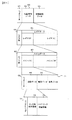
設定した経路に沿った一定範囲、すなわち推奨経路から所定の距離内にある切り出し領域内の地図を切り出す方法を図5に示す。車載機100において目的地が設定されると、経路探索サーバ404は現在地52と目的地53を設定し、その間をつなぐ推奨経路54が周知の経路探索演算処理により設定される。この経路における切り出し範囲55は、たとえば図中に網がけで示す範囲のように経路54から一定範囲内の部分として設定される。また、現在地52と目的地53の周辺では、他の経路上よりも広い範囲を設定される。この切り出し範囲55の領域内にある地図データが、地図を一定範囲ごとに区切ったメッシュ51の各メッシュごとに抽出され、地図データとして情報配信センター400から車載機100に配信される。
【0015】
探索結果を車載機100へ送信する際の地図データの構造例を図6に示す。なお、本発明に関する部分以外のデータ構成については、以下の説明において詳細を省略する。地図データ60は、ヘッダデータ61、地図情報データ62、および経路誘導データ63により構成される。ヘッダデータ61には各種の管理用データが含まれる。経路誘導データ63は、探索経路上に定められた誘導ポイント、たとえば交差点や建造物などの名称データや形状データ、あるいは右左折データなどを含むデータにより構成される。地図情報データ62は、レイヤ数64およびレイヤデータ65より構成される。レイヤデータ65は、レイヤ(0)〜レイヤ(N)に含まれるデータによって構成される。レイヤ(0)〜レイヤ(N)は、それぞれ異なる縮尺の地図として定義される。レイヤ数64はレイヤの数(この例ではN+1個)を示す。
【0016】
レイヤデータ65のうち、たとえばレイヤ(0)のデータは、メッシュ数66およびメッシュデータ67により構成される。他のレイヤについても同様のデータにより構成される。メッシュデータ67は、メッシュ(0)〜メッシュ(M)に含まれるデータによって構成される。メッシュ(0)〜メッシュ(M)は、レイヤ(0)を定義する縮尺の地図を一定の範囲ごとに区切った領域として定義される。メッシュ数66はメッシュの数(この例ではM+1個)を示す。
【0017】
メッシュデータ67のうち、たとえばメッシュ(0)のデータは、ヘッダデータ68、道路データ69、背景データ70、および名称データ71により構成される。他のメッシュについても同様のデータにより構成される。ヘッダデータ68には各種の管理用データが含まれる。背景データ70は、道路以外に地図上に表示される背景、たとえば鉄道や川、湖などに関するデータにより構成される。名称データ71は、道路データ69および背景データ70に示される道路や背景の名称を表すデータにより構成される。
【0018】
道路データ69は、リンク列ヘッダ72、リンク列形状情報73、およびノード・リンク接続情報74により構成される。リンク列ヘッダ72には各種の管理用データが含まれ、その中に後述のノード・リンク接続情報の有無を示すフラグも含まれる。リンク列形状情報73は、そのリンク列が成す道路の形状に関するデータ、たとえばリンク列の各ノードの座標が含まれる。ノード・リンク接続情報74は、リンク列の各ノードがそれぞれどのように接続されているか、すなわち道路間の接続に関するデータが含まれる。第1の実施の形態による地図情報配信システムでは、地図データの送信時にこのノード・リンク接続情報を制限することで、送信データ量を削減する。
【0019】
なお、地図配信サーバ403には、図6に示すデータ構造で全国の地図データが記憶されている。すなわち、経路探索要求に従って、全国の地図データベースに基づいて、現在地から目的地までの推奨経路に沿った地図が切り出されて、図6の配信用地図データが作成される。後述する高架下か否かの情報や交差点数も、切り出す前の全国の地図データに含まれているものとする。
【0020】
第1の実施の形態による地図情報配信システムにおいて、経路に沿って切り出したマップについて、データ削減の対象となる部位を図示したものを図7に示す。経路探索サーバ404により設定された経路80から、前述の方法により切り出された地図取得範囲81において、以下に説明するようにノード・リンク接続情報74を制限することで、送信データ量を削減する。
【0021】
まず、都心部に設定された範囲82では、ノード・リンク接続情報を送信データに含める。これは、都心部においては道路数が多く、道路間の接続に関する情報が必要となるためである。次にGPS受信が良好でないと設定された地域、たとえば高架下などの範囲83では、ノード・リンク接続情報を送信データに含める。これは、GPS受信が良好でない地域では、車両の位置を特定するのが困難であり、マップマッチングを精度良く行う必要があるためである。反対に、GPS受信が良好な地域として、市街地ではない郊外の道路などがある。これらの道路ではGPS信号による位置検出が精度良く行われるため、マップマッチングを省略してもよいからである。次に経路80に接続する道路、たとえば道路84などでは、ノード・リンク接続情報を送信データに含める。
【0022】
以上説明した以外の範囲にある道路、たとえば道路85などでは、ノード・リンク接続情報を送信データに含めない。これは、経路80に沿って車両を誘導する際には、ノード・リンク接続情報が示す道路間の接続に関する情報が不要であるためである。
【0023】
図8に、第1の実施の形態による地図情報配信システムにおいて、ノード・リンク接続情報を削減する処理の制御フローを示す。この制御フローは地図配信サーバ403で実行されるプログラムに基づく処理フローであり、常時実行されている。ステップS1では、要求受付サーバ402からの地図要求を受信したか判定する。地図要求を受信した場合は次のステップS2へ進み、受信しない場合は再度ステップS1を繰り返す。
【0024】
ステップS2では、地図メッシュを選択する。ここで地図メッシュとは、地図レイヤごとに一定の範囲毎(区画毎)に区切った地図データの一群を表す。地図レイヤとは、異なる縮尺ごとに定義された地図データの階層構造を表す。ステップS3では、選択したメッシュにおける切り出し範囲を設定する。ステップS4では、切り出し範囲内の地図データを抽出する。ステップS2〜4について以下に詳述する。
【0025】
ステップS2において、現在地から目的地に至る推奨経路が通過する全てのメッシュを抽出し、いずれかひとつのメッシュを選択する。図8に示す制御フローの処理で始めてステップS2が実行される場合は、現在地が位置するメッシュが第1番目のメッシュとして選択される。次に、現在地が位置するメッシュに隣接し、推奨経路が通過するメッシュないし推奨経路付近のメッシュが第2番目のメッシュとして選択され、さらに、このメッシュに隣接し、推奨経路が通過するメッシュが第3番目のメッシュとして選択される。そして、最後は目的地が位置するメッシュが第n番目のメッシュとして選択される。
【0026】
ステップS3において、選択されたメッシュに応じて地図データ抽出のための切り出し範囲が設定される。現在地が位置する第1番目のメッシュが選択されると、現在地を中心として例えば半径250mの現在地周辺領域を特定し、これを切り出し範囲として設定する。この現在地周辺領域が隣接するメッシュに重なる場合、隣接メッシュの重なり領域も現在地周辺領域切り出し範囲と設定する。
【0027】
さらに、現在地が位置するメッシュ内において、現在地周辺領域外の推奨経路を特定する。この推奨経路を中心とする例えば幅500mの推奨経路に沿った領域を特定し、これを切り出し範囲として設定する。当該メッシュにおいて現在地周辺領域外の領域に推奨経路が存在しない場合は、このような経路周辺領域の切り出し範囲は設定されない。
【0028】
ステップS2において、現在地が位置するメッシュに隣接し、推奨経路が通過する第2番目のメッシュが選択されたときは、ステップS3おいて、第2番目のメッシュ内を通過する経路を中心とする例えば幅500mの経路に沿った領域を特定し、切り出し範囲として設定する。
【0029】
ステップS2において、目的地が位置する第n番目のメッシュが選択されたときは、ステップS3において、目的地を中心として例えば半径250mの目的地周辺領域を特定し、これを切り出し範囲として設定する。この目的地周辺領域が隣接するメッシュに重なる場合、隣接メッシュの重なり領域も目的地周辺領域切り出し範囲と設定する。さらに、目的地が位置するメッシュ内において、目的地周辺領域外の推奨経路を特定する。そして、この推奨経路を中心とする例えば幅500mの推奨経路に沿った領域を特定し、これを切り出し範囲として設定する。当該メッシュにおいて目的地周辺領域外の領域に推奨経路が存在しない場合は、このような経路周辺領域の切り出し範囲は設定されない。
【0030】
ステップS4では、ステップS3で設定された切り出し範囲内の地図データを抽出する。道路データは、始点ノードと終点ノードを複数のノードで接続するリンク列データとして表されている。各ノードは座標値を有している。そこで、切り出し範囲として設定された領域内の座標値を有する全てのノード情報を含む地図データが抽出される。
【0031】
このようなデータ抽出処理を現在地から目的地が位置するメッシュに至るまで行い、現在地から目的地に至る経路に沿った所定範囲内の経路周辺領域内の全ての地図データが抽出される。
【0032】
図5(b)は図5(a)のメッシュ511の拡大図である。メッシュ511内の経路54を中心として例えば幅500mの経路周辺領域541内には、ノードn11〜n17で示されるリンク列R11と、ノードn21〜n23で示されるリンク列R12が存在している。リンク列R11,R12の内、経路周辺領域541内のノードn14,n15,n16,n21,n22が抽出される。n11〜n13,n17,n23は切り出し範囲外であり地図データは抽出されない。なお、推奨経路54は通過しないが経路周辺領域がかかる隣接メッシュ内に存在する全てのノード情報を含む地図データも抽出される。
【0033】
ステップS5では、選択した地図メッシュにおいて、データの削減要求があるかを判定する。この判定は、たとえば車載機100から送信されるデータに含まれるフラグにより行う。なお、データの削減要求は、入力装置107の操作によりモードを設定することなどで行われる。データの削減要求がある場合は次のステップS6へ進み、ない場合はデータの削減を行わないと判断してステップS10に進む。ステップS6では、設定された推奨経路の全長距離が所定値以上であるかを判定する。この所定値は、たとえば設定された経路により切り出される範囲の地図データ量が多く、データ量を削減する必要が生じる距離により決定される。距離が所定値以上であれば次のステップS7へ進み、所定値以上でない場合はデータの削減を行わないと判断してステップS10へ進む。なお、ステップS6を省略してもよい。すなわち、推奨経路全体のデータ量の大きさにかかわらず、ステップS7、S8、S9それぞれの条件でデータ量を削減するだけでもよい。
【0034】
ステップS7では、選択した地図メッシュがGPSの受信状態が良好な地域として設定されているかを判定する。この設定は、たとえば高架下などはGPSの受信状態が良好でない地域として設定される。GPSの受信状態が良好な地域と設定されている場合は、データの削減を行うと判断してステップS11へ進む。GPSの受信状態が良好でない地域と設定されている場合は、次のステップS8へ進む。
【0035】
ステップS8では、選択した地図メッシュが都市部として設定されているかを判定する。この設定は、たとえば道路の交差数が所定値以上である場合に、都市部として設定される。都市部として設定されていない場合は、データの削減を行うと判断してステップS11へ進む。都市部として設定されている場合は、次のステップS9へ進む。
【0036】
ステップS9では、選択した地図メッシュ内の各道路について、それが経路に接続する道路であるかを判定する。経路に接続する道路でない場合は、データの削減を行うと判断してステップS11へ進む。経路に接続する道路である場合は、データの削減を行わないと判断してステップS10へ進む。
【0037】
ステップS10では、データの削減を行わないとして、ノード・リンク接続情報を送信データに含める。一方、ステップS11では、データの削減を行うとして、ノード・リンク接続情報を送信データに含めない。
【0038】
ステップS12では、ステップS2〜S11の処理が、地図要求を受信した経路における地図メッシュ全てについて終了したかを判定する。終了した場合は次のステップS13に進み、終了していない場合はステップS2へ戻って再度処理を行う。ステップS13では、ステップS12までの処理でそれぞれ決定された、ノード・リンク接続情報を含む、または含まない地図データをまとめ、送信データとして図6に示す所定のデータフォーマットに編集する。このとき、ノード・リンク接続情報を含まないデータについては、そのことを示すフラグを付与する。ステップS14では、ステップS13で編集された地図データを、要求受付サーバへ返信する。このようにして送信データの削減が行われる。
【0039】
なお、車載機100は、推奨経路から逸脱したとき、受信し記憶しているノード・リンク接続情報を用いて再経路探索演算を行う。このとき、上述したように特定の条件によりノード・リンク接続情報が含まれていない領域については、再経路探索演算はできない。したがって、車載機100は情報配信センター400へ再経路探索要求を送信する。また、ノード・リンク接続情報が含まれている領域であっても、データ量が不足して車載機100では再経路探索演算ができないことがある。この場合も、情報配信センター400へ再経路探索要求を送信する。
【0040】
上述した第1の実施の形態による地図情報配信システムによれば、次の作用効果が得られる。
(1)都市部でない地域、あるいはGPS電波の受信状態が良好な地域では、推奨経路に接続する道路が少なく、表示する必要性が低いから、ノード・リンク接続情報を削除した。その結果、情報配信センターから車載機へ配信する推奨経路付近の地図データのデータ量を削減することができ、通信時間と通信コストを低減できる。
(2)データ量を削除したことを示す情報を付与した。その結果、車載機においてノード・リンク接続情報がないことを認識できる。
【0041】
――第2の実施の形態――
本発明による地図情報配信システムの第2の実施の形態を説明する。第1の実施の形態では、ノード・リンク接続情報を必要に応じて送信データから除くことでデータの削減を実現していたが、第2の実施の形態では、道路の形状を示すリンク列形状情報を必要に応じて間引くことで、データの削減を実現する。システム構成および経路に沿った一定範囲内の地図の切り出し方法は、第1の実施の形態と同じであるため、ここでは省略する。
【0042】
第2の実施の形態による地図情報配信システムにおいて、経路に沿って切り出したマップについて、データ削減の対象となる部位を図示したものを図9に示す。経路探索サーバ404により設定された経路80から、前述の方法により切り出された地図取得範囲81において、以下に説明するようにリンク列形状情報73を制限することで、送信データ量を削減する。
【0043】
誘導ポイント86および88へ進入する手前(図の左上方向より右下方向へ経路を進むものとする)の、一定距離の範囲87および89では、リンク列形状情報はそのままとする。これは、誘導ポイント付近では車両を誘導するために正確な道路形状が必要となるためである。ここで誘導ポイントとは、経路の進行方向が変化する地点、たとえば交差点を曲がる場所などをいう。それ以外の範囲にある推奨経路あるいは他の道路、たとえば道路85などでは、リンク列形状情報の一部を送信データから除く。これは、経路に沿って車両を誘導する際には、全てのリンク列形状情報により正確な道路形状を示す必要がないためである。
【0044】
図10に、上述した方法でリンク列形状情報の一部を送信データから除くことにより、車載機において表示される道路形状がどのように変化するのかを示す。リンク列形状情報が全てあるときの道路の形状は、図10(a)に示すように、90a〜90sの各ノードの座標位置が決定され、道路はこれらのノードを接続した線によって表される。一方、リンク列形状情報の一部を除くことにより、図10(b)に示すように、たとえば90a、90d、90e、90i、90k、90l、90n、90s以外のノードについては、地図データから除かれる(間引かれる)。このときの道路は、間引かれずに残ったノードを接続した形状となる。どのノードを間引くかは所定のアルゴリズムにより行われ、たとえば各ノードについて、間引く前後での道路形状の変化量を計算し、直線道路や曲率の大きい道路など変化量が所定値以内であった場合には、そのノードを間引くこととする。
【0045】
図11に、第2の実施の形態による地図情報配信システムにおいて、リンク列形状情報の一部を除く処理の制御フローを示す。この制御フローは地図配信サーバ403で実行されるプログラムに基づく処理フローであり、常時実行されている。ステップS1〜ステップS4では、第1の実施の形態による地図情報配信システムにおける、ノード・リンク接続情報を削減する処理と同様の処理を実行する。
【0046】
ステップS5Aでは、選択した地図メッシュにおいて、形状間引きの要求があるかを判定する。この判定は、たとえば車載機100から送信されるデータに含まれるフラグにより行う。データ削減要求と同様に、ユーザが入力装置107から形状間引き要求モードを設定することができる。形状間引きの要求がある場合は次のステップS15へ進み、ない場合はデータの削減を行わないと判断してステップS10Aに進む。
【0047】
ステップS15では、選択した地図メッシュから抽出した各リンク列データについて、誘導ポイントの手前所定距離内であるかを判定する。誘導ポイントの手前所定距離内でない場合は、形状間引きによるデータの削減を行うと判断してステップS11Aへ進む。誘導ポイントの手前所定距離内である場合は、次のステップS10Aへ進む。
【0048】
ステップS10Aでは、形状間引きによるデータの削減を行わないとして、リンク列形状情報を全て送信データに含める。一方、ステップS11Aでは、形状間引きによるデータの削減を行うとして、リンク列形状情報の一部を除いて形状間引きを行う。
【0049】
ステップS12〜ステップS14では、第1の実施の形態による地図情報配信システムにおける、ノード・リンク接続情報を削減する処理と同様の処理を実行する。この際、ステップS13において、第1の実施の形態による地図情報配信システムにおけるノード・リンク接続情報を削減する処理と同様に、形状間引きを行った(リンク列形状情報の一部を除いた)データについては、そのことを示すフラグを付与する。このようにして送信データの削減が行われる。
【0050】
上述した第2の実施の形態による地図情報配信システムによれば、次の作用効果が得られる。
(1)推奨経路であっても、誘導ポイントへ進入する方向の一定範囲内でない経路においては、道なりに走行することになり道路形状は大まかでよいとして、形状間引きによるデータ量を削減した。あるいは、推奨道路に接続されている道路であっても誘導ポイントに関係がない接続道路についても同様であり、形状間引きによるデータ量を削減した。その結果、情報配信センターから車載機へ配信する推奨経路付近の地図データのデータ量を削減することができ、通信時間と通信コストを低減できる。
(2)データ量を削除したことを示す情報を付与した。その結果、車載機において形状間引きされていることを認識できる。
【0051】
――第3の実施の形態――
本発明による地図情報配信システムの第3の実施の形態を説明する。第3の実施の形態による地図情報配信システムでは、推奨経路に接続しない道路に対し、第2の実施の形態と同様にリンク列形状情報の一部を除くことにより、データ量の削減を行う。これを図9を用いて説明する。経路80に接続する道路、たとえば道路84などでは、リンク列形状情報はそのままとする。経路80に接続しない道路、たとえば道路85などでは、リンク列形状情報の一部を送信データから除く。
【0052】
図12に、第3の実施の形態による地図情報配信システムにおいて、リンク列形状情報の一部を除く処理の制御フローを示す。この制御フローは地図配信サーバ403で実行されるプログラムに基づく処理フローであり、常時実行されている。なお、制御フロー以外については第2の実施の形態と同じであるため、ここでは説明を省略する。ステップS1〜ステップS5Aでは、第2の実施の形態による地図情報配信システムにおける、リンク列形状情報の一部を除く処理フローと同様の処理を実行する。ステップS6〜ステップS8では、第1の実施の形態による地図情報配信システムにおける、ノード・リンク接続情報を削減する処理と同様の処理を実行する。
【0053】
ステップS9Aでは、選択した地図メッシュ内の各道路について、それが経路に接続する道路であるかを判定する。経路に接続する道路でない場合は、データの削減を行うと判断してステップS11Aへ進む。経路に接続する道路である場合は、データの削減を行わないと判断してステップS10Aへ進む。ステップS10A〜ステップS14では、第2の実施の形態による地図情報配信システムにおける、リンク列形状情報の一部を除く処理と同様の処理を実行する。このようにして送信データの削減が行われる。
【0054】
上述した第3の実施の形態による地図情報配信システムによれば、次の作用効果が得られる。
(1)推奨経路に沿って切り出される道路であっても、推奨経路に接続されていない道路、たとえば、平行している道路などは、経路誘導表示にとってあまり意味がないとして、形状間引きによるデータ量を削減した。その結果、情報配信センターから車載機へ配信する推奨経路付近の地図データのデータ量を削減することができ、通信時間と通信コストを低減できる。
【0055】
――第4の実施の形態――
本発明による地図情報配信システムの第4の実施の形態を説明する。第4の実施の形態では、経路に沿って切り出した地図の付近に所定の条件を満たすPOI(Point Of Interest;観光地や各種施設の情報)が存在する場合、そのPOI付近の範囲を拡大して、地図の切り出し範囲を補正する。システム構成は、第1〜第3の実施の形態と同じであるため、ここでは省略する。
【0056】
第4の実施の形態による地図情報配信システムにおいて、POI付近の地図の切り出し範囲を補正する方法を図示したものを図13に示す。まず、経路探索サーバ404により設定された経路80から、第1の実施の形態による地図情報配信システムにおいて説明したのと同様の方法にて、地図取得範囲81を切り出す。次に、所定の条件を満たすPOI地点91および92が、地図取得範囲81の領域より外の所定距離内にあり、かつ経路80に接続する道路93および94によって、経路80から進入できるとともに経路80へ戻れる位置にあるとする。このとき、POI地点91と92、およびPOI地点91と92に接続する道路93と94の付近に、地図取得範囲95および96を設定する。その後、地図取得範囲81に地図取得範囲95、96を加えた地図取得範囲に従って、送信する地図データが抽出される。
【0057】
上述したPOIの条件には、たとえば次のようなものが考えられる。
(1)ユーザが、あらかじめ興味ある施設の種類を車載機100に設定しておく。
(2)経路上の通過予定時刻を推定し、その時刻に適した種類の施設である場合。たとえば、食事時間帯である場合には飲食店を選ぶなど。
(3)燃料残量が所定値以下となる走行距離・時刻・地理的位置などを推定し、そのときにガソリンスタンドなどの給油施設を選ぶようにする。
【0058】
図14に、第4の実施の形態による地図情報配信システムにおいて、POI付近の地図の切り出し範囲を補正する処理の制御フローを示す。この制御フローは地図配信サーバ403で実行されるプログラムに基づく処理フローであり、常時実行されている。ステップS1〜ステップS3では、第1〜第3の実施の形態による地図情報配信システムにおける制御フローと同様の処理を実行する。
【0059】
ステップS16では、ユーザが興味を持っているPOIが設定されているかを判定する。この判定は、たとえば、車載機100において入力装置107の操作により行われたPOIの設定を、経路探索要求の際に情報配信センター400に送信することにより行われる。または、ユーザの利用状況に合わせて、上述した(2)、(3)のように情報配信センター400で自動的に設定するPOIにより行ってもよい。設定されている場合はステップS17へ進み、設定されていない場合はステップS4へ進む。
【0060】
ステップS17では、ステップS16により判定されたPOIが、ステップS3により設定された切り出し範囲の外の所定距離内に存在するかを判定する。この判定に用いられる所定距離は、たとえば、前述したステップS16での車載機100におけるPOIの設定の際に、合わせて選択される。所定距離内に存在する場合はステップS18へ進み、所定距離内に存在しない場合はステップS4へ進む。
【0061】
ステップS18では、ステップS17で所定距離内に存在すると判定されたPOIについて、経路に接続する道路沿いにあるかを判定する。経路に接続する道路沿いにある場合はステップS19へ進み、ない場合はステップS4へ進む。
【0062】
ステップS19では、ステップS17で所定距離内に存在すると判定されたPOIの周囲、およびステップS18で経路に接続すると判定された道路について、経路から当該POIまでの周囲を、前述のように所定距離の範囲で選択する。そして、ステップS3で設定した切り出し範囲に追加する。ステップS4およびステップS12〜S14では、第1〜第3の実施の形態による地図情報配信システムにおける制御フローと同様の処理を実行する。このようにして、地図の切り出し範囲が再設定される。
【0063】
上述した第4の実施の形態による地図情報配信システムによれば、次の作用効果が得られる。
(1)条件を満たすPOIが付近に存在する場合は、地図の切り出し範囲を推奨経路から当該POIを含む範囲まで拡大した。このときの条件は、ユーザからの設定、推奨経路上の推定時刻に適した飲食店などの施設、燃料残量が所定値以下となる場合のガソリンスタンドなどとした。その結果、必要に応じた地図データをタイムリーに提供することができる。
【0064】
以上の実施の形態では、情報配信装置を要求受付サーバ402、経路探索サーバ404および地図配信サーバ403で実現している。また、受信手段を通信端末200、表示手段を表示モニタ106で実現している。さらに、情報端末を車載機100と通信端末200で構成している。しかし、これらはあくまで一例であり、本発明の特徴が損なわれない限り、各構成要素は上記実施の形態に限定されない。
【0065】
【発明の効果】
(1)本発明によれば、所定の条件下では配信地図データから道路接続情報を削除したり、道路形状を間引くようにしたりしたので、配信データが削減でき、通信時間と通信コストを低減できる。
(2)ユーザが興味のあるあらかじめ設定したPOIなどについては、推奨経路から所定距離以上離れている切り出し領域外の場合であってもデータ抽出して表示するようにしたので、データ量を削減しつつ必要な情報を提示することができる。
【図面の簡単な説明】
【図1】第1〜第4の実施の形態による地図情報配信システムの構成を示すブロック図
【図2】第1〜第4の実施の形態による地図情報配信システムにおける車載機の構成を示すブロック図
【図3】第1〜第4の実施の形態による地図情報配信システムにおける情報配信センターの構成を示すブロック図
【図4】経路探索要求時のデータの流れを示す図
【図5】経路に沿った一定範囲内の地図を切り出す方法を示す図
【図6】送信する地図データの構造の例を示す図
【図7】ノード・リンク接続情報を削除する条件を示す図
【図8】第1の実施の形態による地図情報配信システムにおけるノード・リンク接続情報の削除の処理の流れを示すフローチャート
【図9】形状間引きを行う条件を示す図
【図10】形状間引きを行ったときの地図形状の変化の様子を示す図
【図11】第2の実施の形態による地図情報配信システムにおける形状間引きを行う処理の流れを示すフローチャート
【図12】第3の実施の形態による地図情報配信システムにおける形状間引きを行う処理の流れを示すフローチャート
【図13】切り出し範囲の再設定を行う条件を示す図
【図14】第4の実施の形態による地図情報配信システムにおける切り出し範囲の再設定を行う処理の流れを示すフローチャート
【符号の説明】
1 車両
60 地図データ
69 道路データ
73 リンク列形状情報
74 ノード・リンク接続情報
80 経路
81 地図取得範囲
82 都心部
83 GPS受信が良好でない地域
84 経路に接続する道路
85 経路に接続しない道路
86,88 誘導ポイント
87,89 誘導ポイントへ進入する手前方向の形状間引き範囲
91,92 POI
93,94 経路からPOIへの道路
95,96 POI付近の地図取得範囲
100 ナビゲーション装置(車載機)
200 通信端末
300 移動体通信網
400 情報配信センター
401 外部インタフェース
402 要求受付サーバ
403 地図配信サーバ
404 経路探索サーバ
405 位置情報検索サーバ
406 交通情報サーバ
407 顧客DBサーバ[0001]
BACKGROUND OF THE INVENTION
The present invention relates to a map data distribution technique for distributing map data used in an information terminal such as a navigation device mounted on a vehicle by communication.
[0002]
[Prior art]
There is an information communication navigation system mainly composed of a navigation device mounted on a vehicle and an information distribution center that performs route search to a destination and distribution of map data in response to a request from the navigation device. In this information communication navigation system, a map data distribution method conventionally used distributes map data obtained by cutting out a certain range near a route as it is (Patent Document 1).
[0003]
[Patent Document 1]
JP 2002-107169 A
[0004]
[Problems to be solved by the invention]
In the prior art, since the extracted map data is distributed as it is, when the destination is far away, there is a problem that the amount of transmission data is large and the communication time and communication cost increase.
[0005]
An object of the present invention is to reduce the amount of data to be transmitted by restricting the amount of information of data that is not important in navigation to a destination.
[0006]
[Means for Solving the Problems]
(1) The map data transmission method according to the invention of
(2) It is preferable to set a geographical condition for map data and determine whether to delete road connection information from the extracted map data based on the set geographical condition. The geographical condition includes an urban area and an area with good GPS reception. When the map data is not an urban area, the road connection information is deleted when the map data is an area with good GPS reception.
(3) The road connection information can be deleted for road data that is not connected to the extracted recommended route.
(4) As in the map data transmission method according to the invention of
(5) The road shape of the recommended route may be simplified under predetermined conditions. That is, a part of the road shape information may be deleted for a recommended route other than the recommended route that is on the approach route side of the guide point and is within a predetermined distance from the guide point, or other roads.
(6) With the above data transmission method. It is preferable to provide information indicating that the road connection information has been deleted. Also, the distance from the current location of the determined recommended route to the destination is calculated, and based on the calculated distance, the total data size of the extracted map data is estimated, and the estimated total data size is larger than the predetermined value. If it is larger, the road connection information may be deleted.
(7) An information distribution apparatus according to the invention of
(8) An information terminal according to the invention of claim 14 is a receiving means for receiving map data transmitted from the information distribution device, and a recommended route and map data within a predetermined distance from the recommended route based on the received map data. Display means for displaying.
(9) The map data transmission method according to the invention of
(10) The facility data that satisfies the predetermined condition can be facility data that can be entered from a road connected to the recommended route and located at a point where the recommended route can be returned. Alternatively, it is possible to extract data related to the type of facility suitable for the scheduled passage time when traveling on the recommended route. Furthermore, it is possible to extract a fueling facility based on the estimated travel distance, estimated time, or estimated geographical position when the fuel remaining amount when traveling on the recommended route is equal to or less than a predetermined value.
(11) An information terminal according to the invention of
[0007]
DETAILED DESCRIPTION OF THE INVENTION
-First embodiment-
A first embodiment in which the present invention is applied to a map information distribution system in a car navigation apparatus will be described with reference to FIG. A car navigation device (hereinafter referred to as an in-vehicle device) 100 mounted on the
[0008]
FIG. 2 is a system block diagram showing the configuration of the in-
[0009]
The
[0010]
FIG. 3 is a system block diagram showing the configuration of the
[0011]
The
[0012]
FIG. 4 shows a data flow at the time of a route search request in the map information distribution system according to the first embodiment. When the destination is input from the
[0013]
In this way, the
[0014]
FIG. 5 shows a method of cutting out a map in a cutout region within a predetermined distance from a set range along the set route, that is, a recommended route. When the destination is set in the in-
[0015]
An example of the structure of the map data when transmitting the search result to the in-
[0016]
Of the
[0017]
Among the
[0018]
The
[0019]
The
[0020]
In the map information distribution system according to the first embodiment, FIG. 7 shows a portion that is subject to data reduction for a map cut out along a route. By limiting the node / link connection information 74 as described below in the
[0021]
First, in the
[0022]
Node / link connection information is not included in the transmission data for roads outside the range described above, such as
[0023]
FIG. 8 shows a control flow of processing for reducing node / link connection information in the map information distribution system according to the first embodiment. This control flow is a processing flow based on a program executed by the
[0024]
In step S2, a map mesh is selected. Here, the map mesh represents a group of map data divided into a certain range (each section) for each map layer. A map layer represents a hierarchical structure of map data defined for different scales. In step S3, a cutout range in the selected mesh is set. In step S4, map data within the cutout range is extracted. Steps S2 to S4 will be described in detail below.
[0025]
In step S2, all meshes through which the recommended route from the current location to the destination passes are extracted, and any one mesh is selected. When Step S2 is executed for the first time in the control flow process shown in FIG. 8, the mesh where the current location is located is selected as the first mesh. Next, the mesh that is adjacent to the mesh where the current location is located and the recommended route passes or the mesh near the recommended route is selected as the second mesh, and the mesh that is adjacent to this mesh and that passes the recommended route is the first mesh. Selected as the third mesh. Finally, the mesh where the destination is located is selected as the nth mesh.
[0026]
In step S3, a cutout range for extracting map data is set according to the selected mesh. When the first mesh in which the current location is located is selected, a current location peripheral region having a radius of 250 m, for example, is specified with the current location as the center, and this is set as a cutout range. When this current location peripheral region overlaps with an adjacent mesh, the overlapping region of the adjacent mesh is also set as the current location peripheral region cutout range.
[0027]
Further, the recommended route outside the current area is identified in the mesh where the current position is located. For example, an area along the recommended route having a width of 500 m, for example, centered on the recommended route is specified, and this is set as a cutout range. When there is no recommended route in a region outside the current location peripheral region in the mesh, such a route peripheral region cut-out range is not set.
[0028]
In Step S2, when the second mesh that is adjacent to the mesh where the current location is located and the recommended route passes is selected, in Step S3, for example, the route that passes through the second mesh is used as the center. An area along a route having a width of 500 m is specified and set as a cutout range.
[0029]
When the nth mesh in which the destination is located is selected in step S2, a destination peripheral area having a radius of 250 m, for example, is specified in step S3, and this is set as a cutout range. When this destination peripheral region overlaps with the adjacent mesh, the overlapping region of the adjacent mesh is also set as the destination peripheral region cutout range. Further, a recommended route outside the destination peripheral area is specified in the mesh where the destination is located. Then, an area along the recommended route having a width of 500 m, for example, centered on the recommended route is specified, and this is set as a cutout range. When there is no recommended route in a region outside the destination peripheral region in the mesh, such a route peripheral region cut-out range is not set.
[0030]
In step S4, map data within the cutout range set in step S3 is extracted. The road data is represented as link string data connecting a start point node and an end point node with a plurality of nodes. Each node has a coordinate value. Therefore, map data including all node information having coordinate values within the region set as the cutout range is extracted.
[0031]
Such data extraction processing is performed from the current location to the mesh where the destination is located, and all map data in the route peripheral region within a predetermined range along the route from the current location to the destination is extracted.
[0032]
FIG. 5B is an enlarged view of the
[0033]
In step S5, it is determined whether there is a data reduction request in the selected map mesh. This determination is performed based on a flag included in data transmitted from the in-
[0034]
In step S7, it is determined whether the selected map mesh is set as an area where the GPS reception state is good. This setting is set as an area where the GPS reception state is not good, for example, under an overpass. If the GPS reception state is set as a good region, it is determined that data is to be reduced, and the process proceeds to step S11. If it is set as an area where the GPS reception state is not good, the process proceeds to the next step S8.
[0035]
In step S8, it is determined whether the selected map mesh is set as an urban area. This setting is set as an urban area, for example, when the number of road intersections is a predetermined value or more. If it is not set as an urban area, it is determined that data is to be reduced, and the process proceeds to step S11. If it is set as an urban area, the process proceeds to the next step S9.
[0036]
In step S9, it is determined whether each road in the selected map mesh is a road connected to the route. If the road is not connected to the route, it is determined that data reduction is to be performed, and the process proceeds to step S11. If it is a road connected to the route, it is determined not to reduce data, and the process proceeds to step S10.
[0037]
In step S10, the node / link connection information is included in the transmission data on the assumption that data reduction is not performed. On the other hand, in step S11, the node / link connection information is not included in the transmission data because data is reduced.
[0038]
In step S12, it is determined whether the processes in steps S2 to S11 have been completed for all the map meshes in the route that received the map request. If completed, the process proceeds to the next step S13. If not completed, the process returns to step S2 to perform the process again. In step S13, the map data including or not including the node / link connection information determined in the processes up to step S12 are collected and edited as transmission data into a predetermined data format shown in FIG. At this time, a flag indicating that is attached to data not including node / link connection information. In step S14, the map data edited in step S13 is returned to the request reception server. In this way, transmission data is reduced.
[0039]
In addition, when the vehicle-mounted
[0040]
According to the map information distribution system according to the first embodiment described above, the following operational effects are obtained.
(1) In areas that are not urban areas or areas where GPS radio wave reception is good, the number of roads connected to the recommended route is small and the necessity for display is low, so node / link connection information is deleted. As a result, the amount of map data in the vicinity of the recommended route distributed from the information distribution center to the in-vehicle device can be reduced, and the communication time and communication cost can be reduced.
(2) Information indicating that the amount of data was deleted was added. As a result, it can be recognized that there is no node / link connection information in the in-vehicle device.
[0041]
-Second embodiment-
A second embodiment of the map information distribution system according to the present invention will be described. In the first embodiment, the node / link connection information is removed from the transmission data as necessary, but the data reduction is realized. In the second embodiment, the link row shape indicating the shape of the road is used. Reduce data by thinning out information as needed. Since the system configuration and the map extraction method within a certain range along the route are the same as those in the first embodiment, they are omitted here.
[0042]
In the map information distribution system according to the second embodiment, FIG. 9 illustrates a portion that is a target of data reduction for a map cut out along a route. In the
[0043]
In the
[0044]
FIG. 10 shows how the road shape displayed on the vehicle-mounted device changes when a part of the link row shape information is removed from the transmission data by the method described above. As shown in FIG. 10A, the shape of the road when there is all the link row shape information is determined by the coordinate positions of the
[0045]
FIG. 11 shows a control flow of processing for excluding a part of link string shape information in the map information distribution system according to the second embodiment. This control flow is a processing flow based on a program executed by the
[0046]
In step S5A, it is determined whether there is a request for shape thinning in the selected map mesh. This determination is performed based on a flag included in data transmitted from the in-
[0047]
In step S15, it is determined whether each link string data extracted from the selected map mesh is within a predetermined distance before the guidance point. If it is not within the predetermined distance before the guidance point, it is determined that data reduction is performed by shape thinning, and the process proceeds to step S11A. If it is within the predetermined distance before the guidance point, the process proceeds to the next step S10A.
[0048]
In step S10A, all the link string shape information is included in the transmission data on the assumption that data reduction by shape thinning is not performed. On the other hand, in step S11A, assuming that data reduction is performed by shape thinning, shape thinning is performed except for a part of link row shape information.
[0049]
In step S12 to step S14, processing similar to the processing for reducing node / link connection information in the map information distribution system according to the first embodiment is executed. At this time, in step S13, the data obtained by thinning out the shape (excluding a part of the link string shape information) is the same as the processing for reducing the node / link connection information in the map information distribution system according to the first embodiment. For, a flag indicating that is given. In this way, transmission data is reduced.
[0050]
According to the map information distribution system according to the second embodiment described above, the following operational effects are obtained.
(1) Even if it is a recommended route, on a route that is not within a certain range in the direction of approaching the guidance point, it will run like a road and the road shape may be rough. Alternatively, even for roads that are connected to recommended roads, the same applies to connected roads that are not related to the guidance point, and the amount of data by shape thinning is reduced. As a result, the amount of map data in the vicinity of the recommended route distributed from the information distribution center to the in-vehicle device can be reduced, and the communication time and communication cost can be reduced.
(2) Information indicating that the amount of data was deleted was added. As a result, it can be recognized that the shape is thinned in the in-vehicle device.
[0051]
--Third embodiment--
A third embodiment of the map information distribution system according to the present invention will be described. In the map information distribution system according to the third embodiment, the amount of data is reduced by removing part of the link row shape information for roads that are not connected to the recommended route, as in the second embodiment. This will be described with reference to FIG. In the road connected to the
[0052]
FIG. 12 shows a control flow of processing for excluding a part of link string shape information in the map information distribution system according to the third embodiment. This control flow is a processing flow based on a program executed by the
[0053]
In step S9A, it is determined whether each road in the selected map mesh is a road connected to the route. If the road is not connected to the route, it is determined that data reduction is to be performed, and the process proceeds to step S11A. If the road is connected to the route, it is determined that no data reduction is performed, and the process proceeds to step S10A. In step S10A-step S14, the process similar to the process except a part of link row | line | column shape information in the map information delivery system by 2nd Embodiment is performed. In this way, transmission data is reduced.
[0054]
According to the map information distribution system according to the third embodiment described above, the following operational effects can be obtained.
(1) Even if a road is cut out along a recommended route, a road that is not connected to the recommended route, for example, a parallel road, is not meaningful for route guidance display. Reduced. As a result, the amount of map data in the vicinity of the recommended route distributed from the information distribution center to the in-vehicle device can be reduced, and the communication time and communication cost can be reduced.
[0055]
-Fourth embodiment-
A map information distribution system according to a fourth embodiment of the present invention will be described. In the fourth embodiment, when there is a POI (Point Of Interest; information on sightseeing spots and various facilities) that satisfies a predetermined condition near the map cut out along the route, the range near the POI is expanded. Correct the cutout range of the map. Since the system configuration is the same as that of the first to third embodiments, it is omitted here.
[0056]
In the map information distribution system according to the fourth embodiment, FIG. 13 shows a method for correcting the cutout range of the map near the POI. First, the
[0057]
For example, the following POI conditions can be considered.
(1) The user sets the type of facility of interest in the in-
(2) The estimated time of passage on the route is estimated, and the type of facility is suitable for that time. For example, if it is a meal time, select a restaurant.
(3) Estimate the travel distance, time, geographical position, etc. at which the remaining amount of fuel is below a predetermined value, and select a fueling facility such as a gas station at that time.
[0058]
FIG. 14 shows a control flow of processing for correcting the cutout range of the map near the POI in the map information distribution system according to the fourth embodiment. This control flow is a processing flow based on a program executed by the
[0059]
In step S16, it is determined whether a POI in which the user is interested is set. This determination is performed, for example, by transmitting the POI setting made by operating the
[0060]
In step S17, it is determined whether the POI determined in step S16 exists within a predetermined distance outside the cutout range set in step S3. The predetermined distance used for this determination is selected together with the POI setting in the in-
[0061]
In step S18, it is determined whether the POI determined to be present within the predetermined distance in step S17 is along a road connected to the route. If it is along the road connected to the route, the process proceeds to step S19, and if not, the process proceeds to step S4.
[0062]
In step S19, the road around the POI determined to be within the predetermined distance in step S17 and the road determined to be connected to the route in step S18 are routed from the route to the POI with the predetermined distance as described above. Select by range. Then, it is added to the cutout range set in step S3. In step S4 and steps S12 to S14, processing similar to the control flow in the map information distribution system according to the first to third embodiments is executed. In this way, the cutout range of the map is reset.
[0063]
According to the map information distribution system according to the fourth embodiment described above, the following operational effects are obtained.
(1) When a POI that satisfies the condition exists in the vicinity, the map clipping range is expanded from the recommended route to the range including the POI. The conditions at this time were a user setting, a facility such as a restaurant suitable for the estimated time on the recommended route, and a gas station when the remaining fuel amount was a predetermined value or less. As a result, map data according to need can be provided in a timely manner.
[0064]
In the above embodiment, the information distribution apparatus is realized by the
[0065]
【The invention's effect】
(1) According to the present invention, the road connection information is deleted from the distribution map data or the road shape is thinned out under predetermined conditions, so that the distribution data can be reduced and the communication time and communication cost can be reduced. .
(2) For pre-set POI that the user is interested in, data is extracted and displayed even if it is outside the cutout area that is more than a predetermined distance away from the recommended route. However, necessary information can be presented.
[Brief description of the drawings]
FIG. 1 is a block diagram showing a configuration of a map information distribution system according to first to fourth embodiments.
FIG. 2 is a block diagram showing the configuration of an in-vehicle device in the map information distribution system according to the first to fourth embodiments.
FIG. 3 is a block diagram showing a configuration of an information distribution center in the map information distribution system according to the first to fourth embodiments.
FIG. 4 is a diagram showing a data flow when a route search request is made
FIG. 5 is a diagram showing a method of cutting out a map within a certain range along a route.
FIG. 6 is a diagram showing an example of the structure of map data to be transmitted
FIG. 7 is a diagram showing conditions for deleting node / link connection information;
FIG. 8 is a flowchart showing a flow of processing for deleting node / link connection information in the map information distribution system according to the first embodiment;
FIG. 9 is a diagram showing conditions for performing shape thinning
FIG. 10 is a diagram showing how the map shape changes when shape thinning is performed.
FIG. 11 is a flowchart showing a flow of processing for performing shape thinning in the map information distribution system according to the second embodiment;
FIG. 12 is a flowchart showing a flow of processing for performing shape thinning in the map information distribution system according to the third embodiment;
FIG. 13 is a diagram showing conditions for resetting a clipping range
FIG. 14 is a flowchart showing a flow of processing for resetting a cutout range in the map information distribution system according to the fourth embodiment.
[Explanation of symbols]
1 vehicle
60 Map data
69 Road data
73 Link row shape information
74 Node link connection information
80 routes
81 Map acquisition range
82 City center
83 Areas with poor GPS reception
84 Roads connected to the route
85 Roads not connected to the route
86,88 guidance points
87,89 Shape thinning range in the forward direction to enter the guidance point
91,92 POI
93,94 Road to POI road
95,96 Map acquisition range near POI
100 Navigation device (vehicle equipment)
200 Communication terminal
300 Mobile communication network
400 Information distribution center
401 External interface
402 Request reception server
403 Map distribution server
404 route search server
405 Location information search server
406 Traffic Information Server
407 Customer DB server
Claims (19)
前記決定された推奨経路から所定の距離内にある切り出し領域の地図データを前記地図データから抽出し、
前記抽出された地図データから前記道路接続情報を削除するか否かを判断し、
前記判断の結果が削除すると判定された場合、前記抽出された地図データから前記道路接続情報を削除して送信することを特徴とする地図データ送信方法。Based on the map data including road shape information indicating the shape of the road and road connection information indicating the connection state between the roads, a recommended route from the current location to the destination is determined,
Extracting from the map data map data of a cutout area within a predetermined distance from the determined recommended route;
Determine whether to delete the road connection information from the extracted map data,
A map data transmission method comprising: deleting and transmitting the road connection information from the extracted map data when it is determined that the determination result is to be deleted.
地図データに地理的条件を設定し、
前記抽出された地図データから前記道路接続情報を削除するか否かの判断は、前記設定された地理的条件により行うことを特徴とする地図データ送信方法。The map data transmission method according to claim 1,
Set geographical conditions for map data,
The map data transmission method according to claim 1, wherein whether or not to delete the road connection information from the extracted map data is determined according to the set geographical condition.
前記地理的条件は都市部を含み、
前記抽出された地図データが都市部でない場合は、前記道路接続情報を削除すると判断することを特徴とする地図データ送信方法。In the map data transmission method according to claim 2,
The geographical conditions include urban areas;
If the extracted map data is not an urban area, it is determined to delete the road connection information.
前記地理的条件はGPS電波の受信状態が良好である地域を含み、
前記抽出された地図データがGPS電波の受信状態が良好な地域である場合は、前記道路接続情報を削除すると判断することを特徴とする地図データ送信方法。In the map data transmission method according to claim 2 or 3,
The geographical condition includes an area where GPS signal reception is good,
A map data transmission method comprising: determining that the road connection information is to be deleted when the extracted map data is an area where the reception state of GPS radio waves is good.
前記抽出された地図データ中に推奨経路に接続されない道路データが含まれるとき、その道路データに対しては、前記道路接続情報を削除すると判断することを特徴とする地図データ送信方法。In the map data transmission method according to any one of claims 1 to 4,
When the extracted map data includes road data that is not connected to a recommended route, it is determined to delete the road connection information for the road data.
前記決定された推奨経路の現在地から目的地までの距離を計算し、
前記計算された距離に基づいて、前記抽出された地図データの合計データサイズを推定し、
前記推定された合計データサイズが所定値より大きい場合は、前記道路接続情報を削除すると判断することを特徴とする地図データ送信方法。In the map data transmission method according to any one of claims 1 to 5,
Calculating the distance from the current location of the determined recommended route to the destination;
Based on the calculated distance, estimate the total data size of the extracted map data;
When the estimated total data size is larger than a predetermined value, it is determined to delete the road connection information.
前記送信された地図データに、前記道路接続情報の削除が行われたことを示す情報を付与することを特徴とする地図データ送信方法。In the map data transmission method according to any one of claims 1 to 6,
A map data transmission method, comprising: adding information indicating that the road connection information has been deleted to the transmitted map data.
前記決定された推奨経路から所定の距離内にある切り出し領域の地図データを前記地図データから抽出し、
前記抽出された地図データから前記道路形状情報の一部を削除するか否かを判断し、
前記判断の結果が削除すると判定された場合、前記抽出された地図データから前記道路形状情報の一部を削除して送信することを特徴とする地図データ送信方法。Determine the recommended route from your current location to your destination based on map data that includes road shape information that indicates the shape of the road and road connection information that indicates the connection status between the roads.
Extracting from the map data map data of a cutout area within a predetermined distance from the determined recommended route;
Determine whether to delete a part of the road shape information from the extracted map data;
When it is determined that the determination result is to be deleted, a part of the road shape information is deleted from the extracted map data and transmitted.
前記抽出された地図データ中に推奨経路に接続されない道路データが含まれるとき、その道路データに対しては、前記道路形状情報の一部を削除すると判断することを特徴とする地図データ送信方法。The map data transmission method according to claim 8, wherein
When the extracted map data includes road data that is not connected to a recommended route, it is determined that a part of the road shape information is deleted for the road data.
前記決定された推奨経路における誘導ポイントの進入経路側にあり、かつ誘導ポイントから所定距離内にある推奨経路を除いた地図データに対しては、前記道路形状情報の一部を削除すると判断することを特徴とする地図データ送信方法。The map data transmission method according to claim 8 or 9,
It is determined that a part of the road shape information is deleted for map data excluding the recommended route that is on the approach route side of the guide point in the determined recommended route and is within a predetermined distance from the guide point. The map data transmission method characterized by this.
前記決定された推奨経路の現在地から目的地までの距離を計算し、
前記計算された距離に基づいて、前記抽出された地図データの合計データサイズを推定し、
前記推定された合計データサイズが所定値より大きい場合は、前記道路形状情報の一部を削除すると判断することを特徴とする地図データ送信方法。In the map data transmission method in any one of Claims 8-10,
Calculating the distance from the current location of the determined recommended route to the destination;
Based on the calculated distance, estimate the total data size of the extracted map data;
When the estimated total data size is larger than a predetermined value, it is determined to delete a part of the road shape information.
前記送信された地図データに、前記道路形状情報の一部の削除が行われたことを示す情報を付与することを特徴とする地図データ送信方法。In the map data transmission method in any one of Claims 8-11,
A map data transmission method comprising: adding information indicating that a part of the road shape information has been deleted to the transmitted map data.
受信した地図データに基づいて、前記推奨経路およびその推奨経路から所定距離内の地図データを表示する表示手段とを有する情報端末。Receiving means for receiving map data transmitted from the information distribution apparatus according to claim 13;
An information terminal comprising: the recommended route and display means for displaying map data within a predetermined distance from the recommended route based on the received map data.
前記地図データに基づいて、前記決定された推奨経路から所定の距離内にある切り出し領域の道路地図データを抽出するとともに、前記切り出し領域外の施設データのうち、所定の条件を満たす施設データを抽出し、
少なくとも前記切り出し領域内から抽出された道路地図データと、前記切り出し領域外から抽出された施設データと、この施設に接続する道路の地図データを送信することを特徴とする地図データ送信方法。Based on road map data including road shape information indicating the shape of the road and road connection information indicating the connection state between roads, and map data including facility data, a recommended route from the current location to the destination is determined,
Based on the map data, the road map data of the cutout area within a predetermined distance from the determined recommended route is extracted, and the facility data satisfying the predetermined condition is extracted from the facility data outside the cutout area And
A map data transmission method comprising: transmitting at least road map data extracted from within the cutout region, facility data extracted from outside the cutout region, and map data of a road connected to the facility.
前記施設に接続する道路は、前記推奨経路から施設に接続する進入道路と、前記推奨経路に戻る道路であることを特徴とする地図データ送信方法。The map data transmission method of claim 15,
The map data transmission method characterized in that the road connected to the facility is an approach road connecting to the facility from the recommended route and a road returning to the recommended route.
前記所定の条件を満たす施設データは、推奨経路上を走行する際の予定通過時刻に適した種類の施設に関するデータであることを特徴とする地図データ送信方法。The map data transmission method according to claim 15 or 16,
The facility data satisfying the predetermined condition is data relating to a facility of a type suitable for a scheduled passage time when traveling on a recommended route.
前記所定の条件を満たす施設データは、推奨経路上を走行する際の燃料残量が所定値以下になるときの推定走行距離、推定時刻、若しくは推定地理的位置であり、その条件が満足されるときに抽出される施設は給油施設であることを特徴とする地図データ送信方法。The map data transmission method according to any one of claims 15 to 17,
The facility data that satisfies the predetermined condition is an estimated travel distance, estimated time, or estimated geographical position when the remaining fuel amount when traveling on the recommended route is equal to or less than a predetermined value, and the condition is satisfied. A map data transmission method characterized in that the facility that is sometimes extracted is a fueling facility.
受信した地図データに基づいて、前記推奨経路を含みその推奨経路から所定距離内にある切り出し領域内の道路地図データおよび抽出した施設データの施設マークを表示する表示手段とを有することを特徴とする情報端末。Receiving means for receiving map data transmitted by the map data transmitting method according to claim 15;
And a display means for displaying road map data in a cut-out area including the recommended route and within a predetermined distance from the recommended route and a facility mark of the extracted facility data based on the received map data. Information terminal.
Priority Applications (4)
| Application Number | Priority Date | Filing Date | Title |
|---|---|---|---|
| JP2002288824A JP3803629B2 (en) | 2002-10-01 | 2002-10-01 | Map data transmission method, information distribution device, and information terminal |
| US10/529,886 US7339496B2 (en) | 2002-10-01 | 2003-10-01 | Geographic data transmitting method, information delivering apparatus and information terminal |
| PCT/JP2003/012593 WO2004031690A1 (en) | 2002-10-01 | 2003-10-01 | Geographic data transmitting method, information delivering apparatus and information terminal |
| EP03753975.6A EP1553385A4 (en) | 2002-10-01 | 2003-10-01 | Geographic data transmitting method, information delivering apparatus and information terminal |
Applications Claiming Priority (1)
| Application Number | Priority Date | Filing Date | Title |
|---|---|---|---|
| JP2002288824A JP3803629B2 (en) | 2002-10-01 | 2002-10-01 | Map data transmission method, information distribution device, and information terminal |
Publications (2)
| Publication Number | Publication Date |
|---|---|
| JP2004125553A JP2004125553A (en) | 2004-04-22 |
| JP3803629B2 true JP3803629B2 (en) | 2006-08-02 |
Family
ID=32063694
Family Applications (1)
| Application Number | Title | Priority Date | Filing Date |
|---|---|---|---|
| JP2002288824A Expired - Fee Related JP3803629B2 (en) | 2002-10-01 | 2002-10-01 | Map data transmission method, information distribution device, and information terminal |
Country Status (4)
| Country | Link |
|---|---|
| US (1) | US7339496B2 (en) |
| EP (1) | EP1553385A4 (en) |
| JP (1) | JP3803629B2 (en) |
| WO (1) | WO2004031690A1 (en) |
Families Citing this family (65)
| Publication number | Priority date | Publication date | Assignee | Title |
|---|---|---|---|---|
| JP3975998B2 (en) * | 2003-10-16 | 2007-09-12 | 株式会社日立製作所 | Navigation server device |
| US7124023B2 (en) * | 2003-12-12 | 2006-10-17 | Palo Alto Research Center Incorporated | Traffic flow data collection agents |
| JP4684228B2 (en) * | 2004-07-29 | 2011-05-18 | 日立オートモティブシステムズ株式会社 | Map data distribution device, communication terminal, and map distribution method |
| JP2006275774A (en) * | 2005-03-29 | 2006-10-12 | Nissan Motor Co Ltd | Navigation device, updating system of map data, and updating method of the map data |
| US7353034B2 (en) | 2005-04-04 | 2008-04-01 | X One, Inc. | Location sharing and tracking using mobile phones or other wireless devices |
| JP2007147577A (en) * | 2005-10-31 | 2007-06-14 | Aisin Aw Co Ltd | Route guidance system and route guidance method |
| JP4505821B2 (en) * | 2005-11-21 | 2010-07-21 | 株式会社デンソー | Car navigation system and facility search method with narrowed search range |
| US8463238B2 (en) * | 2007-06-28 | 2013-06-11 | Apple Inc. | Mobile device base station |
| US8385946B2 (en) | 2007-06-28 | 2013-02-26 | Apple Inc. | Disfavored route progressions or locations |
| US8204684B2 (en) | 2007-06-28 | 2012-06-19 | Apple Inc. | Adaptive mobile device navigation |
| US8311526B2 (en) * | 2007-06-28 | 2012-11-13 | Apple Inc. | Location-based categorical information services |
| US9066199B2 (en) | 2007-06-28 | 2015-06-23 | Apple Inc. | Location-aware mobile device |
| US8275352B2 (en) | 2007-06-28 | 2012-09-25 | Apple Inc. | Location-based emergency information |
| US8332402B2 (en) | 2007-06-28 | 2012-12-11 | Apple Inc. | Location based media items |
| US9109904B2 (en) | 2007-06-28 | 2015-08-18 | Apple Inc. | Integration of map services and user applications in a mobile device |
| US8290513B2 (en) | 2007-06-28 | 2012-10-16 | Apple Inc. | Location-based services |
| US8774825B2 (en) | 2007-06-28 | 2014-07-08 | Apple Inc. | Integration of map services with user applications in a mobile device |
| US8108144B2 (en) | 2007-06-28 | 2012-01-31 | Apple Inc. | Location based tracking |
| US8180379B2 (en) * | 2007-06-28 | 2012-05-15 | Apple Inc. | Synchronizing mobile and vehicle devices |
| US8762056B2 (en) | 2007-06-28 | 2014-06-24 | Apple Inc. | Route reference |
| US8175802B2 (en) | 2007-06-28 | 2012-05-08 | Apple Inc. | Adaptive route guidance based on preferences |
| US8127246B2 (en) | 2007-10-01 | 2012-02-28 | Apple Inc. | Varying user interface element based on movement |
| US8977294B2 (en) | 2007-10-10 | 2015-03-10 | Apple Inc. | Securely locating a device |
| US20090109022A1 (en) * | 2007-10-31 | 2009-04-30 | Gm Global Technology Operations, Inc. | Method and apparatus for providing in-vehicle fuel related information |
| US8355862B2 (en) | 2008-01-06 | 2013-01-15 | Apple Inc. | Graphical user interface for presenting location information |
| US8452529B2 (en) * | 2008-01-10 | 2013-05-28 | Apple Inc. | Adaptive navigation system for estimating travel times |
| US9250092B2 (en) | 2008-05-12 | 2016-02-02 | Apple Inc. | Map service with network-based query for search |
| US7483786B1 (en) | 2008-05-15 | 2009-01-27 | International Business Machines Corporation | Method and system for selective route search on satellite navigators |
| US8644843B2 (en) | 2008-05-16 | 2014-02-04 | Apple Inc. | Location determination |
| US8369867B2 (en) | 2008-06-30 | 2013-02-05 | Apple Inc. | Location sharing |
| US8359643B2 (en) | 2008-09-18 | 2013-01-22 | Apple Inc. | Group formation using anonymous broadcast information |
| US8666367B2 (en) * | 2009-05-01 | 2014-03-04 | Apple Inc. | Remotely locating and commanding a mobile device |
| US8660530B2 (en) | 2009-05-01 | 2014-02-25 | Apple Inc. | Remotely receiving and communicating commands to a mobile device for execution by the mobile device |
| US8670748B2 (en) | 2009-05-01 | 2014-03-11 | Apple Inc. | Remotely locating and commanding a mobile device |
| JP5316292B2 (en) * | 2009-07-31 | 2013-10-16 | アイシン・エィ・ダブリュ株式会社 | MAP INFORMATION GUIDANCE DEVICE, MAP INFORMATION GUIDANCE METHOD, AND COMPUTER PROGRAM |
| CN101625245A (en) * | 2009-08-07 | 2010-01-13 | 肖湘萍 | Navigation terminal and navigation method |
| DE102010030309A1 (en) | 2010-06-21 | 2011-12-22 | Ford Global Technologies, Llc | Method and device for determining an energy consumption optimized route |
| JP5546409B2 (en) * | 2010-09-30 | 2014-07-09 | 本田技研工業株式会社 | Driving support system |
| US20110225105A1 (en) * | 2010-10-21 | 2011-09-15 | Ford Global Technologies, Llc | Method and system for monitoring an energy storage system for a vehicle for trip planning |
| US20110224852A1 (en) * | 2011-01-06 | 2011-09-15 | Ford Global Technologies, Llc | Methods and system for selectively charging a vehicle |
| US8849499B2 (en) * | 2011-01-06 | 2014-09-30 | Ford Global Technologies, Llc | Methods and systems for monitoring a vehicle's energy source |
| US20120179323A1 (en) * | 2011-01-06 | 2012-07-12 | Ford Global Technologies, Llc | Method and Apparatus for Charging Station Guidance |
| US8548739B2 (en) * | 2011-02-10 | 2013-10-01 | Telenav, Inc. | Navigation system with interactive accelerometer mechanism and method of operation thereof |
| US10453226B1 (en) | 2011-07-26 | 2019-10-22 | Google Llc | Presenting information on a map |
| US20130041552A1 (en) | 2011-08-11 | 2013-02-14 | Ford Global Technologies, Llc | Methods and Apparatus for Estimating Power Usage |
| US8280414B1 (en) | 2011-09-26 | 2012-10-02 | Google Inc. | Map tile data pre-fetching based on mobile device generated event analysis |
| US8907776B2 (en) | 2011-10-05 | 2014-12-09 | Ford Global Technologies, Llc | Method and apparatus for do not disturb message delivery |
| US8886715B1 (en) | 2011-11-16 | 2014-11-11 | Google Inc. | Dynamically determining a tile budget when pre-fetching data in a client device |
| US8711181B1 (en) | 2011-11-16 | 2014-04-29 | Google Inc. | Pre-fetching map data using variable map tile radius |
| US9305107B2 (en) | 2011-12-08 | 2016-04-05 | Google Inc. | Method and apparatus for pre-fetching place page data for subsequent display on a mobile computing device |
| US9197713B2 (en) | 2011-12-09 | 2015-11-24 | Google Inc. | Method and apparatus for pre-fetching remote resources for subsequent display on a mobile computing device |
| US9389088B2 (en) * | 2011-12-12 | 2016-07-12 | Google Inc. | Method of pre-fetching map data for rendering and offline routing |
| US8803920B2 (en) * | 2011-12-12 | 2014-08-12 | Google Inc. | Pre-fetching map tile data along a route |
| US8849742B2 (en) | 2012-01-24 | 2014-09-30 | Ford Global Technologies, Llc | Method and apparatus for providing charging state alerts |
| US9462545B2 (en) | 2013-03-14 | 2016-10-04 | Ford Global Technologies, Llc | Method and apparatus for a battery saver utilizing a sleep and vacation strategy |
| US9066298B2 (en) | 2013-03-15 | 2015-06-23 | Ford Global Technologies, Llc | Method and apparatus for an alert strategy between modules |
| CN103218406B (en) * | 2013-03-21 | 2019-11-26 | 百度在线网络技术(北京)有限公司 | The processing method and equipment of the address information of point of interest |
| DE102015206474A1 (en) * | 2015-04-10 | 2016-10-13 | Robert Bosch Gmbh | Provision of environmental data of a planned route |
| CN106919567B (en) * | 2015-12-24 | 2020-06-02 | 北京四维图新科技股份有限公司 | Method and device for processing POI (Point of interest) address |
| CN109690243B (en) * | 2016-09-16 | 2022-03-01 | 松下电器(美国)知识产权公司 | Three-dimensional data creation method and three-dimensional data creation device |
| JP2017227652A (en) * | 2017-09-06 | 2017-12-28 | パイオニア株式会社 | Image processing device, image processing method, and image processing program |
| JP7063662B2 (en) * | 2018-03-19 | 2022-05-09 | 本田技研工業株式会社 | Notification system, notification method and program |
| CN110556049B (en) * | 2018-06-04 | 2021-11-12 | 百度在线网络技术(北京)有限公司 | Map data processing method, device, server and storage medium |
| KR102586966B1 (en) * | 2018-08-01 | 2023-10-10 | 한화에어로스페이스 주식회사 | Interior-map generation system and interior-exploration robot |
| US11875678B2 (en) | 2019-07-19 | 2024-01-16 | Zoox, Inc. | Unstructured vehicle path planner |
Family Cites Families (15)
| Publication number | Priority date | Publication date | Assignee | Title |
|---|---|---|---|---|
| JP3385657B2 (en) * | 1993-08-10 | 2003-03-10 | トヨタ自動車株式会社 | Car navigation system |
| US5911773A (en) * | 1995-07-24 | 1999-06-15 | Aisin Aw Co., Ltd. | Navigation system for vehicles |
| US5790973A (en) * | 1995-12-19 | 1998-08-04 | Prince Corporation | Last exit warning system |
| JP2000123295A (en) * | 1998-10-15 | 2000-04-28 | Equos Research Co Ltd | Navigation center device, navigation device, navigation system and method |
| US6249740B1 (en) | 1998-01-21 | 2001-06-19 | Kabushikikaisha Equos Research | Communications navigation system, and navigation base apparatus and vehicle navigation apparatus both used in the navigation system |
| US6559865B1 (en) * | 1999-05-21 | 2003-05-06 | Tele Atlas North America, Inc. | Computing sign text for branches of an electronic map network |
| JP4239327B2 (en) | 1999-11-18 | 2009-03-18 | 株式会社エクォス・リサーチ | Navigation method |
| JP3494143B2 (en) * | 1999-11-18 | 2004-02-03 | トヨタ自動車株式会社 | Route guidance information providing system and route guidance information providing method |
| JP3371895B2 (en) * | 1999-11-18 | 2003-01-27 | トヨタ自動車株式会社 | Navigation system, remote navigation device and method, and vehicle-mounted navigation device |
| JP3475142B2 (en) * | 2000-03-01 | 2003-12-08 | 三菱電機株式会社 | Map data transmission device, map data transmission method, and computer-readable recording medium recording a program for causing a computer to execute the map data transmission method |
| DE10010608A1 (en) * | 2000-03-03 | 2001-09-06 | Mannesmann Vdo Ag | Navigation with small data quantities involves comparing distance covered between way points with stored distance to output driving notices when difference below minimum value |
| JP3965895B2 (en) | 2000-10-03 | 2007-08-29 | 株式会社日立製作所 | Communication type navigation device |
| JP2002228480A (en) * | 2001-02-05 | 2002-08-14 | Seiko Epson Corp | Trip plan drafting apparatus, navigation apparatus, portable information terminal equipment and server |
| JP4346834B2 (en) * | 2001-05-02 | 2009-10-21 | 三菱電機株式会社 | Navigation in-vehicle terminal |
| US6691028B2 (en) * | 2002-06-07 | 2004-02-10 | Motorola, Inc. | Server-based navigation system and method of operating same |
-
2002
- 2002-10-01 JP JP2002288824A patent/JP3803629B2/en not_active Expired - Fee Related
-
2003
- 2003-10-01 WO PCT/JP2003/012593 patent/WO2004031690A1/en active Application Filing
- 2003-10-01 EP EP03753975.6A patent/EP1553385A4/en not_active Ceased
- 2003-10-01 US US10/529,886 patent/US7339496B2/en not_active Expired - Fee Related
Also Published As
| Publication number | Publication date |
|---|---|
| JP2004125553A (en) | 2004-04-22 |
| EP1553385A1 (en) | 2005-07-13 |
| WO2004031690A1 (en) | 2004-04-15 |
| US7339496B2 (en) | 2008-03-04 |
| EP1553385A4 (en) | 2013-06-19 |
| US20060007022A1 (en) | 2006-01-12 |
Similar Documents
| Publication | Publication Date | Title |
|---|---|---|
| JP3803629B2 (en) | Map data transmission method, information distribution device, and information terminal | |
| JP4087678B2 (en) | Map data transmission method | |
| EP0833290B1 (en) | Method and apparatus for searching a route | |
| US6941220B2 (en) | Apparatus and method for vehicle navigation | |
| EP0702208B1 (en) | Method and system of route selection | |
| EP2573521B1 (en) | Selective download of corridor map data | |
| JP4695830B2 (en) | Area map providing device for moving body | |
| US6415222B1 (en) | Navigation system and storage medium | |
| EP0955520B1 (en) | Route searching device | |
| US20070155404A1 (en) | Method for displaying traffic information and navigation system | |
| US20050140524A1 (en) | Method and apparatus for communicating map and route guidance information for vehicle navigation | |
| EP2597424A2 (en) | Road data creating device, method, and program | |
| EP1243896A2 (en) | Map information providing apparatus and method | |
| EP1662231A2 (en) | Map drawing method and system, navigation apparatus and input/output device | |
| JP2004126036A (en) | Distribution map data structure, distribution map data preparation method, distribution map data preparation device, and terminal equipment | |
| JP2005114546A (en) | System and method for providing route information | |
| US20040267447A1 (en) | Vehicle navigation system and method | |
| JP4591307B2 (en) | Map information distribution system | |
| JP4571169B2 (en) | Navigation system, route search server, terminal device, and route guidance method | |
| JP4547826B2 (en) | Navigation device and navigation program | |
| JP4643628B2 (en) | Map data transmitting apparatus and method | |
| JPH0996538A (en) | Path searching device | |
| EP1174685A1 (en) | Method and apparatus for providing geographical regions for point of interest selection | |
| JPH07234993A (en) | Navigation device | |
| JP3221239B2 (en) | Route search device |
Legal Events
| Date | Code | Title | Description |
|---|---|---|---|
| A621 | Written request for application examination |
Free format text: JAPANESE INTERMEDIATE CODE: A621 Effective date: 20050511 |
|
| TRDD | Decision of grant or rejection written | ||
| A01 | Written decision to grant a patent or to grant a registration (utility model) |
Free format text: JAPANESE INTERMEDIATE CODE: A01 Effective date: 20060418 |
|
| A61 | First payment of annual fees (during grant procedure) |
Free format text: JAPANESE INTERMEDIATE CODE: A61 Effective date: 20060508 |
|
| R150 | Certificate of patent or registration of utility model |
Free format text: JAPANESE INTERMEDIATE CODE: R150 |
|
| FPAY | Renewal fee payment (event date is renewal date of database) |
Free format text: PAYMENT UNTIL: 20090512 Year of fee payment: 3 |
|
| FPAY | Renewal fee payment (event date is renewal date of database) |
Free format text: PAYMENT UNTIL: 20100512 Year of fee payment: 4 |
|
| FPAY | Renewal fee payment (event date is renewal date of database) |
Free format text: PAYMENT UNTIL: 20100512 Year of fee payment: 4 |
|
| S111 | Request for change of ownership or part of ownership |
Free format text: JAPANESE INTERMEDIATE CODE: R313111 |
|
| FPAY | Renewal fee payment (event date is renewal date of database) |
Free format text: PAYMENT UNTIL: 20100512 Year of fee payment: 4 |
|
| R371 | Transfer withdrawn |
Free format text: JAPANESE INTERMEDIATE CODE: R371 |
|
| FPAY | Renewal fee payment (event date is renewal date of database) |
Free format text: PAYMENT UNTIL: 20110512 Year of fee payment: 5 |
|
| FPAY | Renewal fee payment (event date is renewal date of database) |
Free format text: PAYMENT UNTIL: 20120512 Year of fee payment: 6 |
|
| FPAY | Renewal fee payment (event date is renewal date of database) |
Free format text: PAYMENT UNTIL: 20120512 Year of fee payment: 6 |
|
| S111 | Request for change of ownership or part of ownership |
Free format text: JAPANESE INTERMEDIATE CODE: R313111 |
|
| FPAY | Renewal fee payment (event date is renewal date of database) |
Free format text: PAYMENT UNTIL: 20120512 Year of fee payment: 6 |
|
| R350 | Written notification of registration of transfer |
Free format text: JAPANESE INTERMEDIATE CODE: R350 |
|
| FPAY | Renewal fee payment (event date is renewal date of database) |
Free format text: PAYMENT UNTIL: 20130512 Year of fee payment: 7 |
|
| FPAY | Renewal fee payment (event date is renewal date of database) |
Free format text: PAYMENT UNTIL: 20140512 Year of fee payment: 8 |
|
| R250 | Receipt of annual fees |
Free format text: JAPANESE INTERMEDIATE CODE: R250 |
|
| R250 | Receipt of annual fees |
Free format text: JAPANESE INTERMEDIATE CODE: R250 |
|
| R250 | Receipt of annual fees |
Free format text: JAPANESE INTERMEDIATE CODE: R250 |
|
| LAPS | Cancellation because of no payment of annual fees |