JP2010044392A - 公開エリア地図 - Google Patents
公開エリア地図 Download PDFInfo
- Publication number
- JP2010044392A JP2010044392A JP2009188115A JP2009188115A JP2010044392A JP 2010044392 A JP2010044392 A JP 2010044392A JP 2009188115 A JP2009188115 A JP 2009188115A JP 2009188115 A JP2009188115 A JP 2009188115A JP 2010044392 A JP2010044392 A JP 2010044392A
- Authority
- JP
- Japan
- Prior art keywords
- image
- area
- map
- grid
- tiles
- Prior art date
- Legal status (The legal status is an assumption and is not a legal conclusion. Google has not performed a legal analysis and makes no representation as to the accuracy of the status listed.)
- Granted
Links
- 238000000034 method Methods 0.000 claims abstract description 67
- 238000004364 calculation method Methods 0.000 claims description 11
- 238000004422 calculation algorithm Methods 0.000 description 16
- 230000006870 function Effects 0.000 description 13
- 230000004888 barrier function Effects 0.000 description 12
- 230000000694 effects Effects 0.000 description 7
- 238000012015 optical character recognition Methods 0.000 description 7
- 230000008569 process Effects 0.000 description 7
- 238000012545 processing Methods 0.000 description 7
- 238000000926 separation method Methods 0.000 description 7
- 238000005259 measurement Methods 0.000 description 6
- 239000003086 colorant Substances 0.000 description 5
- 239000013598 vector Substances 0.000 description 5
- 238000004891 communication Methods 0.000 description 4
- 235000013305 food Nutrition 0.000 description 4
- 244000025254 Cannabis sativa Species 0.000 description 3
- 238000003491 array Methods 0.000 description 3
- 238000011161 development Methods 0.000 description 3
- 230000018109 developmental process Effects 0.000 description 3
- 238000013138 pruning Methods 0.000 description 3
- 238000010586 diagram Methods 0.000 description 2
- 238000009499 grossing Methods 0.000 description 2
- 238000010845 search algorithm Methods 0.000 description 2
- 230000032258 transport Effects 0.000 description 2
- XLYOFNOQVPJJNP-UHFFFAOYSA-N water Substances O XLYOFNOQVPJJNP-UHFFFAOYSA-N 0.000 description 2
- RSWGJHLUYNHPMX-UHFFFAOYSA-N Abietic-Saeure Natural products C12CCC(C(C)C)=CC2=CCC2C1(C)CCCC2(C)C(O)=O RSWGJHLUYNHPMX-UHFFFAOYSA-N 0.000 description 1
- 238000012935 Averaging Methods 0.000 description 1
- 238000012952 Resampling Methods 0.000 description 1
- KHPCPRHQVVSZAH-HUOMCSJISA-N Rosin Natural products O(C/C=C/c1ccccc1)[C@H]1[C@H](O)[C@@H](O)[C@@H](O)[C@@H](CO)O1 KHPCPRHQVVSZAH-HUOMCSJISA-N 0.000 description 1
- 230000006978 adaptation Effects 0.000 description 1
- 230000008859 change Effects 0.000 description 1
- 238000012790 confirmation Methods 0.000 description 1
- 239000000284 extract Substances 0.000 description 1
- 231100001261 hazardous Toxicity 0.000 description 1
- 238000002955 isolation Methods 0.000 description 1
- 239000004973 liquid crystal related substance Substances 0.000 description 1
- 239000003550 marker Substances 0.000 description 1
- 238000007620 mathematical function Methods 0.000 description 1
- 230000007246 mechanism Effects 0.000 description 1
- 235000021178 picnic Nutrition 0.000 description 1
- 238000004321 preservation Methods 0.000 description 1
- 230000004044 response Effects 0.000 description 1
- 239000011435 rock Substances 0.000 description 1
- 230000035945 sensitivity Effects 0.000 description 1
- 230000005236 sound signal Effects 0.000 description 1
- 238000012360 testing method Methods 0.000 description 1
- KHPCPRHQVVSZAH-UHFFFAOYSA-N trans-cinnamyl beta-D-glucopyranoside Natural products OC1C(O)C(O)C(CO)OC1OCC=CC1=CC=CC=C1 KHPCPRHQVVSZAH-UHFFFAOYSA-N 0.000 description 1
- 238000012546 transfer Methods 0.000 description 1
Images


Classifications
-
- G—PHYSICS
- G01—MEASURING; TESTING
- G01C—MEASURING DISTANCES, LEVELS OR BEARINGS; SURVEYING; NAVIGATION; GYROSCOPIC INSTRUMENTS; PHOTOGRAMMETRY OR VIDEOGRAMMETRY
- G01C21/00—Navigation; Navigational instruments not provided for in groups G01C1/00 - G01C19/00
- G01C21/20—Instruments for performing navigational calculations
- G01C21/206—Instruments for performing navigational calculations specially adapted for indoor navigation
-
- G—PHYSICS
- G01—MEASURING; TESTING
- G01C—MEASURING DISTANCES, LEVELS OR BEARINGS; SURVEYING; NAVIGATION; GYROSCOPIC INSTRUMENTS; PHOTOGRAMMETRY OR VIDEOGRAMMETRY
- G01C21/00—Navigation; Navigational instruments not provided for in groups G01C1/00 - G01C19/00
- G01C21/38—Electronic maps specially adapted for navigation; Updating thereof
- G01C21/3863—Structures of map data
- G01C21/387—Organisation of map data, e.g. version management or database structures
- G01C21/3881—Tile-based structures
-
- G—PHYSICS
- G09—EDUCATION; CRYPTOGRAPHY; DISPLAY; ADVERTISING; SEALS
- G09B—EDUCATIONAL OR DEMONSTRATION APPLIANCES; APPLIANCES FOR TEACHING, OR COMMUNICATING WITH, THE BLIND, DEAF OR MUTE; MODELS; PLANETARIA; GLOBES; MAPS; DIAGRAMS
- G09B29/00—Maps; Plans; Charts; Diagrams, e.g. route diagram
- G09B29/10—Map spot or coordinate position indicators; Map reading aids
- G09B29/106—Map spot or coordinate position indicators; Map reading aids using electronic means
-
- G—PHYSICS
- G01—MEASURING; TESTING
- G01C—MEASURING DISTANCES, LEVELS OR BEARINGS; SURVEYING; NAVIGATION; GYROSCOPIC INSTRUMENTS; PHOTOGRAMMETRY OR VIDEOGRAMMETRY
- G01C21/00—Navigation; Navigational instruments not provided for in groups G01C1/00 - G01C19/00
- G01C21/38—Electronic maps specially adapted for navigation; Updating thereof
- G01C21/3804—Creation or updating of map data
- G01C21/3807—Creation or updating of map data characterised by the type of data
- G01C21/383—Indoor data
Landscapes
- Engineering & Computer Science (AREA)
- Remote Sensing (AREA)
- Radar, Positioning & Navigation (AREA)
- Physics & Mathematics (AREA)
- General Physics & Mathematics (AREA)
- Automation & Control Theory (AREA)
- Theoretical Computer Science (AREA)
- Business, Economics & Management (AREA)
- Educational Technology (AREA)
- Educational Administration (AREA)
- Mathematical Physics (AREA)
- Databases & Information Systems (AREA)
- Navigation (AREA)
- Processing Or Creating Images (AREA)
- Instructional Devices (AREA)
- User Interface Of Digital Computer (AREA)
Abstract
【解決手段】公開エリア地図に関連したシステム及び方法が開示される。例えば、1つの方法は、レイアウトの画像を取得する段階を含む。レイアウトは、人が動き回る現実世界のエリアを表す。グリッドが画像上に適用される。グリッドは、画像の接地エリアを満たすタイルを含む。ルーティング可能な地図が、グリッドの関数として生成される。ルーティング可能な地図は、レイアウト内でポイントツーポイントルーティングを行うように構成される。
【選択図】図1
Description
本特許出願は、同日に出願された名称「COST BASED OPEN AREA MAPS」の同時係属米国特許出願第 号(代理人事件簿第N0275US号)、名称「OPEN AREA MAPS WITH RESTRICTION CONTENT」の同時係属米国特許出願第 号(代理人事件簿第N0276US号)、名称「END USER IMAGE OPEN AREA MAPS」の同時係属米国特許出願第 号(代理人事件簿第N0277US号)、名称「POSITIONING OPEN AREA MAPS」の同時係属米国特許出願第 号(代理人事件簿第N0278US号)、名称「OPEN AREA MAPS WITH GUIDANCE」の同時係属米国特許出願第 号(代理人事件簿第N0279US号)、及び名称「OPEN AREA MAPS BASED ON VECTOR GRAPHICS FORMAT IMAGES」の同時係属米国特許出願第 号(代理人事件簿第N0280US号)の関連出願であり、これら特許出願の開示内容全体は引用により本明細書に組み込まれる。
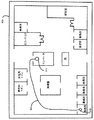
上記の説明においては、ルーティングに使用される公開エリア地図は、建物フロア又は平面図を中心とするものである。しかしながら、記載の特徴は、多数の公開領域に使用することができる。例えば、公園及び屋外環境のレイアウトの画像を取得して、上述のように、ルーティング可能な地図を生成するのに使用することができる。ピクニック場、ジャングルジム、滑り台、トイレ及び他のエリアのような公園の異なるセクションは、別個の基準領域として定義することができる。従って、ルーティングは、上述の事務所間のルーティングと同様に、草で覆われたエリア全体に生成することができる。公園は、ルーティングに組み込むことができる散歩道を有する場合がある。或いは、所定の散歩道又はルートは、ルーティングにおいて回避することができる。また、ナビゲート不可能なタイルは、境界又は障壁用に使用又は実装することができる。例えば、公園内の湖、池又は他の水域は、水中を通ってルーティングされないように、ナビゲート不可能なタイルで境界付けることができる。危険エリア、列車軌道又は岩などの他の障壁又は所望の境界線をナビゲート不可能なタイルと関連付けることができる。或いは、ナビゲート可能なタイルは、これらの境界線の一部を通過する理由がある場合に使用することができる。例えば、湖の一方の側から反対の側に人を連れて行くためにボートが存在する場合、ボートエリアは、ナビゲート可能なタイルと関連付けることができる。
104 画像ソース
108 ネットワーク
112 デバイス
116 ユーザデバイス
120 ネットワーク又は接続部
124 ディスプレイ
128 プロセッサ
132 メモリ
134 アプリケーション
136 入力デバイス
140 ディスプレイ
144 プロセッサ
148 メモリ
170 データベース
180 ネットワーク
Claims (28)
- 公開エリア地図を生成する方法であって、
人が動き回る現実世界のエリアを表すレイアウトの画像を取得する段階と、
前記画像の地上エリアを埋めるタイルを含むグリッドを前記画像に適用する段階と、
前記グリッドの関数としてルーティング可能な地図を生成する段階と、
を含み、
前記ルーティング可能な地図が、前記レイアウト内でポイントツーポイントルーティングを行うように構成されることを特徴とする方法。 - 前記レイアウトの画像が建物平面図の画像を含む、請求項1に記載の方法。
- 前記ルーティング可能な地図を生成する段階が、
前記グリッドに対応するナビゲート不可能なエリアを指定する段階と、
複数の基準領域を生成する段階と、
前記複数の基準領域を前記グリッドとコンパイルする段階と、
を含む、請求項1に記載の方法。 - 前記複数の基準領域を生成する段階が、
前記画像内に複数の基準画像オブジェクトを識別する段階と、
前記それぞれの基準画像オブジェクトに対応する境界を形成することによって、前記複数の基準領域を生成する段階と、を含む請求項3に記載の方法。 - 前記境界を形成する段階が2値化画像の一部をベクトル化する段階を含む、請求項4に記載の方法。
- 前記境界がナビゲート不可能なタイルと関連付けられる、請求項4に記載の方法。
- 前記境界が、除去されたタイルと関連付けられる、請求項4に記載の方法。
- 前記複数の基準領域内のタイルが、前記それぞれの基準領域にリンク付けされる、請求項3に記載の方法。
- 前記グリッド及び前記複数の基準領域が、コンパイル前に別個の空間層内にある、請求項3に記載の方法。
- 前記タイルが実質的に均一である、請求項1に記載の方法。
- 前記ポイントツーポイントルーティングが、接続されたタイルを介して経路を生成する、請求項1に記載の方法。
- 公開エリア地図平面図を生成する方法であって、
建物のフロアについての現実世界のフロアレイアウトに対応する、第1の平面図の第1のグラフィック表現を取得する段階と、
第1のグリッドを前記第1のグラフィック表現に適用する段階と、
前記第1のグリッドの関数として第1のルーティング可能な平面図を生成する段階と、
を含み、
前記第1のルーティング可能な平面図が、ポイントツーポイントルーティングを行うように構成されることを特徴とする方法。 - 前記建物の別のフロアについての現実世界のフロアレイアウトに対応する、第2の平面図の第2のグラフィック表現を取得する段階と、
第2のグリッドを前記第2のグラフィック表現に適用する段階と、
前記第2のグリッドの関数として第2のルーティング可能な平面図を生成する段階と、
接続ポイントを介して前記第1のルーティング可能な平面図と前記第2のルーティング可能な平面図とをリンク付けする段階とを更に含む、請求項12に記載の方法。 - 前記接続ポイントが、エレベータ、階段吹き抜け又はエスカレータを表す、請求項13に記載の方法。
- 公開エリア地図においてルーティングする方法であって、
人が動き回る現実世界のエリアを表すレイアウトの画像を含む前記公開エリア地図において選択された目的地を識別する段階と、
基礎となるグリッドを更に含む前記公開エリア地図において原点から前記選択された目的地までのルートを計算する段階と、
前記計算に基づいて前記原点から前記選択された目的地までの経路を生成する段階と、
を含み、
前記経路が前記基礎となるグリッドの接続されたタイルを介して生成されることを特徴とする方法。 - 前記接続されたタイルの各々が、ほぼ1m2の面積に対応するサイズを有する、請求項15に記載の方法。
- 前記接続されたタイルが、接続ポイントを介してリンク付けされるタイルを含む、請求項15に記載の方法。
- 前記ルートを計算する段階が、Douglas−Peucker法を用いる段階を含む、請求項15に記載の方法。
- 前記選択目的地が、前記レイアウトの画像においてあらゆる基準領域を含む、請求項15に記載の方法。
- 公開エリア地図を生成する方法であって、
地図画像を受信する段階と、
前記地図画像上で格子図形を提供するメッシュを前記地図画像に重ね合わせる段階と、
前記地図画像において複数の基準オブジェクトを識別する段階と、
前記それぞれの基準オブジェクトのアウトラインを描く境界を形成することによって複数の基準領域を生成する段階と、
前記複数の基準領域を前記メッシュとコンパイルすることによりルーティング可能な地図を生成する段階とを含み、
前記ルーティング可能な地図が、前記コンパイルされたメッシュに基づいて前記複数の基準領域のいずれかを起点及び終点としてルーティングを行うように構成されることを特徴とする方法。 - 前記複数の基準領域が建築フロアの部屋を表す、請求項20に記載の方法。
- 前記境界が壁部に対応する、請求項20に記載の方法。
- 前記メッシュが3次元グリッドを含む、請求項20に記載の方法。
- 前記地図画像が建物フロアの一時レイアウトに対応し、前記一時レイアウトが約3ヵ月未満にわたって現実世界に存在する、請求項20に記載の方法。
- 公開エリア地図を生成する方法を実行するコンピュータ実行可能命令を含むコンピュータ可読記憶媒体であって、前記方法が、
人が動き回る現実世界のエリアを表すレイアウトに関する、壁部を含む既存画像を取得する段階と、
前記既存画像を使用して連続したタイルのグリッドを形成する段階とを含み、
前記グリッドが、前記現実世界のエリア内の歩行者アクセス可能な連続サブエリアに対応する形状を有し、
前記形状が、前記既存画像内の前記壁部に対応する境界線を有する、ことを特徴とする方法。 - ルーティングソフトウェアアプリケーションによって使用されて第1の場所と第2の場所との間でルートを求めることができるエリアのデジタル地図を作成する方法であって、
前記エリアの画像を規則的な大きさのタイルのグリッドと重ね合わせる段階と、
前記画像のナビゲート可能な部分を重ね合わせる各タイルを、前記画像の別のナビゲート可能な部分を重ね合わせる直近の別のタイルまでの移動を可能にする特性と関連付ける段階と、
前記タイル及び対応する場所の表現を含むデータファイルを前記エリアのデジタル地図として格納する段階とを含む方法。 - 第1の場所と第2の場所との間でルートを求めるためにルーティングソフトウェアアプリケーションにより使用することができるエリアのデジタル地図を作成する方法であって、
前記エリアの画像を規則的な大きさのタイルのグリッドと重ね合わせる段階と、
各タイルを複数のナビゲート可能な特性から選択されたナビゲート可能な特性と関連付ける段階であって、前記タイルのナビゲート可能な特性が、重ね合わされた前記画像の当該部分から引き継がれ、且つ前記ナビゲート可能な特性が、直近の別のナビゲート可能なタイルに(i)ナビゲート不可能であること及び(ii)ナビゲート可能であることを含む当該段階と、更に、
前記タイル、対応する場所、及びこれに関連した前記ナビゲート可能な特性の表現を含むデータファイルを前記エリアのデジタル地図として格納する段階を含むことを特徴とする方法。 - コンピュータ可読媒体上に格納されているエリアのデータ表現であって、
規則的な大きさのタイルのグリッドを表し、前記タイルの各々の位置を示すデータを含むデータ構造と、
前記エリアの関連画像とを備え、
前記タイルの位置が前記画像内のエリアのナビゲート可能な部分に対応することを特徴とするデータ表現。
Applications Claiming Priority (2)
| Application Number | Priority Date | Filing Date | Title |
|---|---|---|---|
| US12/179,635 US8099237B2 (en) | 2008-07-25 | 2008-07-25 | Open area maps |
| US12/179,635 | 2008-07-25 |
Publications (2)
| Publication Number | Publication Date |
|---|---|
| JP2010044392A true JP2010044392A (ja) | 2010-02-25 |
| JP5684976B2 JP5684976B2 (ja) | 2015-03-18 |
Family
ID=41207320
Family Applications (1)
| Application Number | Title | Priority Date | Filing Date |
|---|---|---|---|
| JP2009188115A Expired - Fee Related JP5684976B2 (ja) | 2008-07-25 | 2009-07-24 | 公開エリア地図 |
Country Status (5)
| Country | Link |
|---|---|
| US (2) | US8099237B2 (ja) |
| EP (1) | EP2148167B8 (ja) |
| JP (1) | JP5684976B2 (ja) |
| CN (1) | CN101634568B (ja) |
| AU (2) | AU2009202021A1 (ja) |
Cited By (5)
| Publication number | Priority date | Publication date | Assignee | Title |
|---|---|---|---|---|
| JP2014232115A (ja) * | 2009-10-01 | 2014-12-11 | クアルコム,インコーポレイテッド | 建物用の経路案内グラフ |
| JP2015028484A (ja) * | 2010-07-13 | 2015-02-12 | クゥアルコム・インコーポレイテッドQualcomm Incorporated | 屋内尤度ヒートマップ |
| JP2018109811A (ja) * | 2016-12-28 | 2018-07-12 | キヤノンマーケティングジャパン株式会社 | 情報処理装置、情報処理システム、その制御方法及びプログラム |
| WO2019073653A1 (ja) * | 2017-10-12 | 2019-04-18 | 株式会社日立製作所 | 駐車管理システム及びその方法 |
| JP2019133047A (ja) * | 2018-02-01 | 2019-08-08 | パイオニア株式会社 | 地図データ構造 |
Families Citing this family (88)
| Publication number | Priority date | Publication date | Assignee | Title |
|---|---|---|---|---|
| US8339417B2 (en) * | 2008-07-25 | 2012-12-25 | Navteq B.V. | Open area maps based on vector graphics format images |
| US20100021013A1 (en) * | 2008-07-25 | 2010-01-28 | Gale William N | Open area maps with guidance |
| US8374780B2 (en) * | 2008-07-25 | 2013-02-12 | Navteq B.V. | Open area maps with restriction content |
| US8099237B2 (en) | 2008-07-25 | 2012-01-17 | Navteq North America, Llc | Open area maps |
| US20100023251A1 (en) * | 2008-07-25 | 2010-01-28 | Gale William N | Cost based open area maps |
| US8417446B2 (en) * | 2008-07-25 | 2013-04-09 | Navteq B.V. | Link-node maps based on open area maps |
| US8229176B2 (en) | 2008-07-25 | 2012-07-24 | Navteq B.V. | End user image open area maps |
| US8825387B2 (en) * | 2008-07-25 | 2014-09-02 | Navteq B.V. | Positioning open area maps |
| KR101633889B1 (ko) * | 2009-02-18 | 2016-06-28 | 삼성전자주식회사 | 격자지도를 이용한 경로 생성 장치 및 방법 |
| US8812015B2 (en) * | 2009-10-01 | 2014-08-19 | Qualcomm Incorporated | Mobile device locating in conjunction with localized environments |
| US8880103B2 (en) | 2009-10-12 | 2014-11-04 | Qualcomm Incorporated | Method and apparatus for transmitting indoor context information |
| US8676493B2 (en) * | 2009-11-30 | 2014-03-18 | Honeywell International Inc. | Systems and methods for better alarm management |
| US20110172916A1 (en) * | 2010-01-14 | 2011-07-14 | Qualcomm Incorporated | Mobile Device Positioning In A Constrained Environment |
| US9389085B2 (en) | 2010-01-22 | 2016-07-12 | Qualcomm Incorporated | Map handling for location based services in conjunction with localized environments |
| US8660316B2 (en) * | 2010-03-04 | 2014-02-25 | Navteq B.V. | Navigating on images |
| US20110320114A1 (en) * | 2010-06-28 | 2011-12-29 | Microsoft Corporation | Map Annotation Messaging |
| US20120016872A1 (en) * | 2010-07-13 | 2012-01-19 | Qualcomm Incorporated | Methods and apparatuses for use in generating an encoded routeability graph description |
| US8670618B2 (en) * | 2010-08-18 | 2014-03-11 | Youwho, Inc. | Systems and methods for extracting pedigree and family relationship information from documents |
| US8676623B2 (en) | 2010-11-18 | 2014-03-18 | Navteq B.V. | Building directory aided navigation |
| US8577136B1 (en) | 2010-12-28 | 2013-11-05 | Target Brands, Inc. | Grid pixelation enhancement for in-stock analytics |
| US20120259544A1 (en) * | 2011-04-05 | 2012-10-11 | Christopher Evan Watson | Feature Location and Resource Management System and Method |
| US8818706B1 (en) * | 2011-05-17 | 2014-08-26 | Google Inc. | Indoor localization and mapping |
| US8825392B2 (en) | 2011-06-30 | 2014-09-02 | Navteq B.V. | Map view |
| US8849618B2 (en) * | 2011-07-29 | 2014-09-30 | Xerox Corporation | Method and apparatus for determining placement of devices based on a building layout |
| US20130044957A1 (en) * | 2011-08-19 | 2013-02-21 | Qualcomm Incorporated | Methods and apparatuses for encoding and/or decoding mapped features in an electronic map of a structure |
| US9047688B2 (en) | 2011-10-21 | 2015-06-02 | Here Global B.V. | Depth cursor and depth measurement in images |
| US8553942B2 (en) | 2011-10-21 | 2013-10-08 | Navteq B.V. | Reimaging based on depthmap information |
| US9116011B2 (en) | 2011-10-21 | 2015-08-25 | Here Global B.V. | Three dimensional routing |
| US20130138342A1 (en) * | 2011-11-29 | 2013-05-30 | Jacob ZAID | Method and apparatus for indoor navigation |
| KR20130066354A (ko) * | 2011-12-12 | 2013-06-20 | 현대엠엔소프트 주식회사 | 사용자 단말의 맵매칭 방법 및 장치 |
| KR101822622B1 (ko) * | 2011-12-12 | 2018-01-26 | 현대엠엔소프트 주식회사 | 실내외 경로가 연계된 목적지 탐색 방법 및 사용자 단말 |
| US9024970B2 (en) | 2011-12-30 | 2015-05-05 | Here Global B.V. | Path side image on map overlay |
| US9404764B2 (en) | 2011-12-30 | 2016-08-02 | Here Global B.V. | Path side imagery |
| US9489756B2 (en) * | 2012-01-31 | 2016-11-08 | Autodesk, Inc. | Graph based degree of freedom counter for two dimensional drawings |
| EP2631596B1 (en) * | 2012-02-22 | 2019-04-03 | Harman Becker Automotive Systems GmbH | Navigation method and corresponding navigation system |
| US20130226539A1 (en) * | 2012-02-29 | 2013-08-29 | BVI Networks, Inc. | Method and system for statistical analysis of customer movement and integration with other data |
| US20130246037A1 (en) * | 2012-03-15 | 2013-09-19 | Kenneth Paul Ceglia | Methods and apparatus for monitoring operation of a system asset |
| EP2843366B1 (en) * | 2012-04-23 | 2019-12-04 | Sony Corporation | Information processing device, information processing method and program |
| US20130345967A1 (en) * | 2012-06-21 | 2013-12-26 | Qualcomm Incorporated | Routability graph with predetermined number of weighted edges for estimating a trajectory of a mobile device |
| US8914261B2 (en) * | 2012-07-03 | 2014-12-16 | Xerox Corporation | Systems and methods for employing automated data analysis to define zones for device placement in an operating evironment |
| CN102749083B (zh) * | 2012-07-17 | 2014-12-24 | 中国科学院遥感应用研究所 | 一种实现整合多路网数据的地图构建方法及装置 |
| US9563326B2 (en) | 2012-10-18 | 2017-02-07 | Microsoft Technology Licensing, Llc | Situation-aware presentation of information |
| KR102043293B1 (ko) * | 2012-11-23 | 2019-11-11 | 현대엠엔소프트 주식회사 | 실내 지도를 저장하는 실내 지도 저장 서버 |
| BR112015014540A2 (pt) * | 2012-12-19 | 2017-07-11 | Skf Ab | navegação de rota gráfica |
| EP2951114B1 (en) * | 2013-02-01 | 2017-08-23 | KONE Corporation | An apparatus and a method for elevator allocation using a magnetic field map in an elevator system |
| US9253606B2 (en) | 2013-03-04 | 2016-02-02 | Here Global B.V. | Structure access characteristics determined from mobile unit data |
| CN103335659B (zh) * | 2013-07-02 | 2016-04-06 | 深圳市创互科技有限公司 | 2d/3d地图显示方法以及指路或导航方法 |
| FR3019285B1 (fr) * | 2014-03-26 | 2016-05-06 | Bull Sas | Procede d'assistance au deplacement d'un agent dans un environnement interieur |
| DE102014104619A1 (de) * | 2014-04-02 | 2015-10-08 | Claas Agrosystems Kgaa Mbh & Co. Kg | Planungssystem und Verfahren zur Planung einer Feldbearbeitung |
| US11410394B2 (en) | 2020-11-04 | 2022-08-09 | West Texas Technology Partners, Inc. | Method for interactive catalog for 3D objects within the 2D environment |
| US9977844B2 (en) | 2014-05-13 | 2018-05-22 | Atheer, Inc. | Method for providing a projection to align 3D objects in 2D environment |
| US9813862B2 (en) * | 2014-05-19 | 2017-11-07 | Aerohive Networks, Inc. | Proximity beacon management using a network device |
| US9857191B2 (en) | 2014-05-22 | 2018-01-02 | Telogis, Inc. | Context-based routing and access path selection |
| TW201614194A (en) * | 2014-10-03 | 2016-04-16 | Inst Information Industry | Mobile navigation system and method |
| CN104807468B (zh) * | 2014-11-13 | 2017-06-16 | 厦门大学 | 一种多目的地地图的自动简化及布局优化方法和系统 |
| KR101638378B1 (ko) * | 2014-11-28 | 2016-07-11 | 주식회사 어반베이스 | 2차원 도면에 기반한 3차원 자동 입체모델링 방법 및 프로그램 |
| DE102015211522A1 (de) | 2015-06-23 | 2016-12-29 | Robert Bosch Gmbh | Konzept zum Erstellen einer digitalen Karte eines Parkplatzes |
| CN105183955B (zh) * | 2015-08-21 | 2018-10-30 | 林浩嘉 | 一种多层建筑最优路径规划方法 |
| TWI575222B (zh) * | 2015-09-11 | 2017-03-21 | 蹦世界數位創意股份有限公司 | 基於區域佈局影像產生導引路網的資料處理系統及方法 |
| CN105203095B (zh) * | 2015-09-14 | 2018-11-30 | 博康云信科技有限公司 | 一种室内三维空间实时路径导航方法及导航系统 |
| US9574884B1 (en) * | 2015-09-22 | 2017-02-21 | Cerner Innovation, Inc. | Providing a route through a predefined space |
| US9651385B2 (en) | 2015-09-22 | 2017-05-16 | Cerner Innovation, Inc. | Providing a route through a predefined space |
| US9939276B2 (en) * | 2016-01-28 | 2018-04-10 | Uber Technologies, Inc. | Simplifying GPS data for map building and distance calculation |
| CN105606113B (zh) * | 2016-01-28 | 2017-09-26 | 福州华鹰重工机械有限公司 | 快速规划最优路径方法及装置 |
| CN105910605A (zh) * | 2016-05-30 | 2016-08-31 | 中国科学技术大学苏州研究院 | 一种室内导航动态路径生成方法 |
| CN107957268A (zh) * | 2016-10-18 | 2018-04-24 | 菜鸟智能物流控股有限公司 | 导航数据生成方法及相关设备、物体运送方法及相关设备 |
| US9939272B1 (en) * | 2017-01-06 | 2018-04-10 | TCL Research America Inc. | Method and system for building personalized knowledge base of semantic image segmentation via a selective random field approach |
| US10266370B2 (en) * | 2017-04-24 | 2019-04-23 | Thyssenkrupp Elevator Ag | Systems and methods for automatic rendering of walking path maps for elevator car assignment display |
| EP3631595B1 (en) * | 2017-05-31 | 2021-08-18 | SZ DJI Technology Co., Ltd. | Method and system for operating a movable platform using ray-casting mapping |
| CN107158703B (zh) * | 2017-06-14 | 2018-12-04 | 浙江无端科技股份有限公司 | 一种ai墙面寻路的方法及系统 |
| CN107843267B (zh) * | 2017-10-25 | 2020-04-17 | 广州汽车集团股份有限公司 | 施工路段无人驾驶车辆的路径生成方法及装置 |
| US10410350B2 (en) | 2017-10-30 | 2019-09-10 | Rakuten, Inc. | Skip architecture neural network machine and method for improved semantic segmentation |
| US10395147B2 (en) * | 2017-10-30 | 2019-08-27 | Rakuten, Inc. | Method and apparatus for improved segmentation and recognition of images |
| WO2020033354A2 (en) | 2018-08-06 | 2020-02-13 | Olive Seed Industries, Llc | Methods and systems for personalizing visitor experience at a venue |
| CN110068344B (zh) * | 2019-04-08 | 2021-11-23 | 丰图科技(深圳)有限公司 | 地图数据的制作方法、装置、服务器及存储介质 |
| US11294385B2 (en) * | 2019-06-28 | 2022-04-05 | Robert Bosch Gmbh | System and method for generating a representation of an environment |
| CN111721307B (zh) * | 2020-01-03 | 2022-06-10 | 腾讯科技(深圳)有限公司 | 一种路网地图的生成方法以及相关装置 |
| CN111174758B (zh) * | 2020-01-18 | 2021-07-16 | 湖南工学院 | 一种机器人无信号地形探测的方法 |
| CN114234988B (zh) | 2020-09-09 | 2024-11-29 | 华为技术有限公司 | 一种导航方法、设备及系统 |
| CN112100307B (zh) * | 2020-09-25 | 2023-07-07 | 北京奇艺世纪科技有限公司 | 数据处理方法、寻路处理方法、装置及电子设备 |
| CN112860829A (zh) * | 2021-01-27 | 2021-05-28 | 广州朗国电子科技有限公司 | 一种地图指引系统、地图指引方法及存储介质 |
| CN112818432B (zh) * | 2021-02-20 | 2024-08-16 | 广东三维家信息科技有限公司 | 一种铺砖设计的生成方法、装置、电子设备及存储介质 |
| JP7641789B2 (ja) * | 2021-03-29 | 2025-03-07 | 本田技研工業株式会社 | 情報管理装置、情報管理方法、およびプログラム |
| US12092464B2 (en) | 2021-05-06 | 2024-09-17 | International Business Machines Corporation | Indoor navigational mapping through pixel color matching |
| CN113304480B (zh) * | 2021-05-25 | 2024-07-02 | 网易(杭州)网络有限公司 | 游戏的显示方法、装置和终端 |
| CN114210061B (zh) * | 2021-12-14 | 2024-12-24 | 腾讯科技(深圳)有限公司 | 虚拟场景中的地图交互处理方法、装置、设备及存储介质 |
| CN114706929B (zh) * | 2022-01-30 | 2025-11-18 | 阿里云计算有限公司 | 位置信息处理方法、装置、电子设备、介质及程序产品 |
| US20240114463A1 (en) * | 2022-10-03 | 2024-04-04 | Arris Enterprises Llc | Determining a location of 6 ghz wi-fi access point device for use in obtaining a transmission power level |
Citations (3)
| Publication number | Priority date | Publication date | Assignee | Title |
|---|---|---|---|---|
| JPS63200207A (ja) * | 1987-02-14 | 1988-08-18 | Fujitsu Ltd | 移動経路探索方法 |
| JP2006010563A (ja) * | 2004-06-28 | 2006-01-12 | Jr Higashi Nippon Consultants Kk | 歩行者用ナビゲーションシステム |
| WO2007100632A2 (en) * | 2006-02-24 | 2007-09-07 | Yahoo! Inc. | User-defined private maps |
Family Cites Families (104)
| Publication number | Priority date | Publication date | Assignee | Title |
|---|---|---|---|---|
| US4674048A (en) * | 1983-10-26 | 1987-06-16 | Automax Kabushiki-Kaisha | Multiple robot control system using grid coordinate system for tracking and completing travel over a mapped region containing obstructions |
| US4674773A (en) | 1984-01-23 | 1987-06-23 | Teleco Oilfield Services Inc. | Insulating coupling for drill collars and method of manufacture thereof |
| NL8500529A (nl) * | 1985-02-25 | 1986-09-16 | Ind Contractors Holland Bv | Stelsel voor het bepalen van de positie van een niet aan een vaste baan gebonden voertuig. |
| NL8900056A (nl) | 1989-01-11 | 1990-08-01 | Philips Nv | Werkwijze voor het visueel weergeven van een deel van een topografische kaart, alsmede inrichting geschikt voor een dergelijke werkwijze. |
| JPH0313611A (ja) * | 1989-06-07 | 1991-01-22 | Toshiba Corp | 自動清掃装置 |
| JP2792210B2 (ja) * | 1990-07-03 | 1998-09-03 | 富士電機株式会社 | 無人搬送車の制御方法および制御装置 |
| US5448696A (en) | 1990-11-30 | 1995-09-05 | Hitachi, Ltd. | Map information system capable of displaying layout information |
| US5272638A (en) | 1991-05-31 | 1993-12-21 | Texas Instruments Incorporated | Systems and methods for planning the scheduling travel routes |
| EP0546633A2 (en) | 1991-12-11 | 1993-06-16 | Koninklijke Philips Electronics N.V. | Path planning in an uncertain environment |
| JPH05334430A (ja) | 1992-05-28 | 1993-12-17 | Toshiba Corp | 自動ベクトル化装置 |
| US5491641A (en) * | 1993-10-04 | 1996-02-13 | Lsi Logic Corporation | Towards optical steiner tree routing in the presence of rectilinear obstacles |
| US6321158B1 (en) | 1994-06-24 | 2001-11-20 | Delorme Publishing Company | Integrated routing/mapping information |
| US5938720A (en) | 1995-02-09 | 1999-08-17 | Visteon Technologies, Llc | Route generation in a vehicle navigation system |
| JP3369368B2 (ja) | 1995-10-11 | 2003-01-20 | 富士通株式会社 | 画像処理装置 |
| US5842145A (en) | 1996-07-08 | 1998-11-24 | Zimmer; John S. | Apparatus for providing individualized maps to pedestrians |
| NL1006710C2 (nl) | 1997-08-04 | 1999-02-25 | Frog Navigation Systems B V | Systeem en werkwijze voor het besturen van voertuigen. |
| DE19803659A1 (de) | 1998-01-30 | 1999-08-05 | Nokia Mobile Phones Ltd | Navigationsverfahren, insbesondere für Fahrzeuge |
| US6038559A (en) | 1998-03-16 | 2000-03-14 | Navigation Technologies Corporation | Segment aggregation in a geographic database and methods for use thereof in a navigation application |
| US6259990B1 (en) | 1998-05-15 | 2001-07-10 | Hitachi, Ltd. | Information processing apparatus and pedestrian navigation system using the same |
| US6167332A (en) * | 1999-01-28 | 2000-12-26 | International Business Machines Corporation | Method and apparatus suitable for optimizing an operation of a self-guided vehicle |
| US6338013B1 (en) | 1999-03-19 | 2002-01-08 | Bryan John Ruffner | Multifunctional mobile appliance |
| JP2000293099A (ja) | 1999-04-09 | 2000-10-20 | Toyota Motor Corp | 地図データベース |
| US6850946B1 (en) | 1999-05-26 | 2005-02-01 | Wireless Valley Communications, Inc. | Method and system for a building database manipulator |
| JP2001165671A (ja) * | 1999-12-14 | 2001-06-22 | Pioneer Electronic Corp | ナビゲーションシステム |
| JP3967866B2 (ja) | 2000-04-28 | 2007-08-29 | パイオニア株式会社 | ナビゲーション装置及びナビゲーションプログラムがコンピュータで読取可能に記録された情報記録媒体 |
| US6604126B2 (en) | 2001-04-11 | 2003-08-05 | Richard S. Neiman | Structural data presentation method |
| US6691128B2 (en) | 2001-04-19 | 2004-02-10 | Navigation Technologies Corp. | Navigation system with distributed computing architecture |
| US20020168084A1 (en) | 2001-05-14 | 2002-11-14 | Koninklijke Philips Electronics N.V. | Method and apparatus for assisting visitors in navigating retail and exhibition-like events using image-based crowd analysis |
| KR100420171B1 (ko) * | 2001-08-07 | 2004-03-02 | 삼성광주전자 주식회사 | 로봇 청소기와 그 시스템 및 제어방법 |
| JP3841401B2 (ja) | 2001-09-26 | 2006-11-01 | 株式会社東芝 | 構内案内装置、サーバ装置およびプログラム |
| US20030210139A1 (en) | 2001-12-03 | 2003-11-13 | Stephen Brooks | Method and system for improved security |
| WO2003081470A1 (en) | 2002-02-27 | 2003-10-02 | Industrial Interfaces Limited | 'A risk mapping system' |
| JP3945279B2 (ja) | 2002-03-15 | 2007-07-18 | ソニー株式会社 | 障害物認識装置、障害物認識方法、及び障害物認識プログラム並びに移動型ロボット装置 |
| GB2386971B (en) * | 2002-03-26 | 2005-11-30 | Mcmurtry Ltd | Method of operating an automated land maintenance vehicle |
| US8050521B2 (en) | 2002-07-27 | 2011-11-01 | Archaio, Llc | System and method for simultaneously viewing, coordinating, manipulating and interpreting three-dimensional and two-dimensional digital images of structures for providing true scale measurements and permitting rapid emergency information distribution |
| CA2495227A1 (en) | 2002-08-13 | 2004-02-19 | Drs Communications Company, Llc | Method and system for determining relative positions of networked mobile communication devices |
| US7188056B2 (en) | 2002-09-09 | 2007-03-06 | Maia Institute | Method and apparatus of simulating movement of an autonomous entity through an environment |
| JP4532280B2 (ja) * | 2002-10-23 | 2010-08-25 | シーメンス アクチエンゲゼルシヤフト | 自由面および占有面を有する面を記述するグラフ構造を形成するための方法および装置ならびにプログラムコード手段を有するコンピュータプログラムおよびコンピュータプログラム製品 |
| US6782319B1 (en) | 2002-11-26 | 2004-08-24 | Navteq North America, Llc | Method for organizing map data |
| US20040113937A1 (en) | 2002-12-13 | 2004-06-17 | Sawdey David M | Method and apparatus for improved computer-aided facilities management |
| US7805220B2 (en) | 2003-03-14 | 2010-09-28 | Sharper Image Acquisition Llc | Robot vacuum with internal mapping system |
| KR100471300B1 (ko) * | 2003-04-21 | 2005-03-10 | 현대자동차주식회사 | 네비게이션용 맵 데이터 전송 시스템 및 방법 |
| GB0314770D0 (en) | 2003-06-25 | 2003-07-30 | Ibm | Navigation system |
| US7308118B1 (en) | 2003-08-04 | 2007-12-11 | A. Jay Simecek | Building security, occupant safety, and emergency response |
| JP3994950B2 (ja) | 2003-09-19 | 2007-10-24 | ソニー株式会社 | 環境認識装置及び方法、経路計画装置及び方法、並びにロボット装置 |
| US7719542B1 (en) | 2003-10-10 | 2010-05-18 | Adobe Systems Incorporated | System, method and user interface controls for communicating status information |
| JP4695830B2 (ja) * | 2003-11-10 | 2011-06-08 | 日立オートモティブシステムズ株式会社 | 移動体用領域地図提供装置 |
| CA2627989C (en) | 2003-12-18 | 2013-01-29 | 1626628 Ontario Limited | System, apparatus and method for mapping |
| WO2005069223A2 (en) | 2004-01-15 | 2005-07-28 | Algotec Systems Ltd. | Vessel centerline determination |
| US7272492B2 (en) | 2004-03-16 | 2007-09-18 | The Johns Hopkins University | Path planning for mine countermeasures |
| US7421341B1 (en) | 2004-06-30 | 2008-09-02 | Navteq North America, Llc | Method of collecting information for a geographic database for use with a navigation system |
| US7660441B2 (en) | 2004-07-09 | 2010-02-09 | Southern California, University | System and method for fusing geospatial data |
| US7672778B1 (en) | 2004-07-20 | 2010-03-02 | Navteq North America, Llc | Navigation system with downloaded map data |
| US7439878B2 (en) * | 2004-09-10 | 2008-10-21 | Xanavi Informatics Corporation | Apparatus and method for processing and displaying traffic information in an automotive navigation system |
| US7457262B1 (en) | 2004-11-05 | 2008-11-25 | Cisco Systems, Inc. | Graphical display of status information in a wireless network management system |
| US7376510B1 (en) | 2004-11-05 | 2008-05-20 | Navteq North America, Llc | Map display for a navigation system |
| US7522940B2 (en) * | 2004-11-16 | 2009-04-21 | Sony Ericsson Mobile Communications Ab | Methods and mobile terminals for display of mobile terminal density information |
| KR100745975B1 (ko) | 2004-12-30 | 2007-08-06 | 삼성전자주식회사 | 그리드 맵을 사용하여 최소 이동 경로로 이동하는 방법 및장치 |
| US7260474B1 (en) | 2005-02-08 | 2007-08-21 | Cellco Partnership | GIS point-to-point routing for directions |
| JP2006239844A (ja) | 2005-03-04 | 2006-09-14 | Sony Corp | 障害物回避装置、障害物回避方法及び障害物回避プログラム並びに移動型ロボット装置 |
| US7512485B2 (en) * | 2005-03-29 | 2009-03-31 | International Business Machines Corporation | Method for routing multiple paths through polygonal obstacles |
| US8836580B2 (en) | 2005-05-09 | 2014-09-16 | Ehud Mendelson | RF proximity tags providing indoor and outdoor navigation and method of use |
| US7496445B2 (en) | 2005-04-27 | 2009-02-24 | Proxemics, Llc | Wayfinding |
| DE102005035908A1 (de) | 2005-07-28 | 2007-02-08 | X-Aitment Gmbh | Taktische Analyse von Closed Combat Situationen |
| ATE527518T1 (de) * | 2005-11-09 | 2011-10-15 | Harman Becker Automotive Sys | Bestimmung einer optimalen route mit karten- kacheln |
| US20070118821A1 (en) | 2005-11-18 | 2007-05-24 | Sun Microsystems, Inc. | Displaying consumer device graphics using scalable vector graphics |
| US8363265B2 (en) | 2005-12-07 | 2013-01-29 | Catalina Marketing Corporation | Color printer technology |
| US7587274B2 (en) | 2006-03-14 | 2009-09-08 | Sap Ag | System and method for navigating a facility |
| WO2007115273A2 (en) | 2006-03-31 | 2007-10-11 | Geospot, Inc. | Methods for interaction, sharing, and exploration over geographical locations |
| GB0608069D0 (en) | 2006-04-24 | 2006-05-31 | Pandora Int Ltd | Image manipulation method and apparatus |
| US7598966B2 (en) | 2006-05-03 | 2009-10-06 | Honeywell International Inc. | Methods and systems for automatically rendering information on a display of a building information system |
| US7543882B2 (en) | 2006-05-05 | 2009-06-09 | Ford Global Technologies, Llc | Dual cell rear corner pillar for automobiles |
| US7873469B2 (en) | 2006-06-19 | 2011-01-18 | Kiva Systems, Inc. | System and method for managing mobile drive units |
| JP5273914B2 (ja) | 2006-08-07 | 2013-08-28 | 株式会社パスコ | 位置情報タグの登録方法及び設置補助装置 |
| US7633383B2 (en) | 2006-08-16 | 2009-12-15 | International Business Machines Corporation | Systems and arrangements for providing situational awareness to an operator of a vehicle |
| US20080077597A1 (en) | 2006-08-24 | 2008-03-27 | Lance Butler | Systems and methods for photograph mapping |
| WO2008030889A2 (en) | 2006-09-06 | 2008-03-13 | Johnson Controls Technology Company | Space management system and method |
| US20080062167A1 (en) | 2006-09-13 | 2008-03-13 | International Design And Construction Online, Inc. | Computer-based system and method for providing situational awareness for a structure using three-dimensional modeling |
| JP2008129695A (ja) | 2006-11-17 | 2008-06-05 | Toyota Motor Corp | 移動体の経路生成システム及び経路生成方法 |
| US7751971B2 (en) | 2007-01-17 | 2010-07-06 | Microsoft Corporation | Location mapping for key-point based services |
| US20080183483A1 (en) | 2007-01-17 | 2008-07-31 | Hart Marcia A | Office management solution |
| US8111257B2 (en) | 2007-03-06 | 2012-02-07 | Aiseek Ltd. | System and method for the generation of navigation graphs in real-time |
| US8000892B2 (en) | 2007-06-12 | 2011-08-16 | Campus Destinations, Inc. | Pedestrian mapping system |
| JP5047709B2 (ja) * | 2007-07-04 | 2012-10-10 | 株式会社日立製作所 | 移動装置、システム、移動方法及び移動プログラム |
| EP2179600B1 (en) | 2007-08-06 | 2015-07-01 | TRX Systems, Inc. | Locating, tracking, and/or monitoring people and/or assets both indoors and outdoors |
| US7920961B2 (en) * | 2007-08-29 | 2011-04-05 | Sap Ag | Method and apparatus for path planning and distance calculation |
| US20090088916A1 (en) | 2007-09-28 | 2009-04-02 | Honeywell International Inc. | Method and system for automatic path planning and obstacle/collision avoidance of autonomous vehicles |
| US8531449B2 (en) | 2007-12-18 | 2013-09-10 | Navteq B.V. | System and method for producing multi-angle views of an object-of-interest from images in an image dataset |
| US8209635B2 (en) | 2007-12-20 | 2012-06-26 | Sony Mobile Communications Ab | System and method for dynamically changing a display |
| WO2009080034A2 (en) | 2007-12-20 | 2009-07-02 | 3Djam Aps | System and method for conversion and distribution of graphical objects |
| JP4513073B2 (ja) | 2007-12-25 | 2010-07-28 | アイシン・エィ・ダブリュ株式会社 | ナビゲーション装置およびプログラム |
| US20090237396A1 (en) | 2008-03-24 | 2009-09-24 | Harris Corporation, Corporation Of The State Of Delaware | System and method for correlating and synchronizing a three-dimensional site model and two-dimensional imagery |
| US8761810B2 (en) | 2008-06-27 | 2014-06-24 | Verizon Patent And Licensing Inc. | Premises area map systems and methods |
| US8825387B2 (en) | 2008-07-25 | 2014-09-02 | Navteq B.V. | Positioning open area maps |
| US8229176B2 (en) | 2008-07-25 | 2012-07-24 | Navteq B.V. | End user image open area maps |
| US8374780B2 (en) | 2008-07-25 | 2013-02-12 | Navteq B.V. | Open area maps with restriction content |
| US8339417B2 (en) | 2008-07-25 | 2012-12-25 | Navteq B.V. | Open area maps based on vector graphics format images |
| US8099237B2 (en) | 2008-07-25 | 2012-01-17 | Navteq North America, Llc | Open area maps |
| US20100021013A1 (en) | 2008-07-25 | 2010-01-28 | Gale William N | Open area maps with guidance |
| US20100023251A1 (en) | 2008-07-25 | 2010-01-28 | Gale William N | Cost based open area maps |
| US8417446B2 (en) | 2008-07-25 | 2013-04-09 | Navteq B.V. | Link-node maps based on open area maps |
| US8346474B2 (en) | 2008-08-28 | 2013-01-01 | Honeywell International Inc. | Method of route retrieval |
| US7987051B2 (en) | 2008-10-22 | 2011-07-26 | Xerox Corporation | Method and system for determining an average walk distance to a service |
| US8665488B2 (en) | 2009-06-22 | 2014-03-04 | Xerox Corporation | Optimal mapping of a spatial print infrastructure |
-
2008
- 2008-07-25 US US12/179,635 patent/US8099237B2/en active Active
-
2009
- 2009-05-21 AU AU2009202021A patent/AU2009202021A1/en not_active Abandoned
- 2009-06-01 EP EP09251447.0A patent/EP2148167B8/en active Active
- 2009-07-24 JP JP2009188115A patent/JP5684976B2/ja not_active Expired - Fee Related
- 2009-07-27 CN CN200910165196.9A patent/CN101634568B/zh not_active Expired - Fee Related
-
2011
- 2011-12-28 US US13/338,630 patent/US8594930B2/en not_active Expired - Fee Related
-
2016
- 2016-01-14 AU AU2016200214A patent/AU2016200214B2/en not_active Ceased
Patent Citations (3)
| Publication number | Priority date | Publication date | Assignee | Title |
|---|---|---|---|---|
| JPS63200207A (ja) * | 1987-02-14 | 1988-08-18 | Fujitsu Ltd | 移動経路探索方法 |
| JP2006010563A (ja) * | 2004-06-28 | 2006-01-12 | Jr Higashi Nippon Consultants Kk | 歩行者用ナビゲーションシステム |
| WO2007100632A2 (en) * | 2006-02-24 | 2007-09-07 | Yahoo! Inc. | User-defined private maps |
Cited By (12)
| Publication number | Priority date | Publication date | Assignee | Title |
|---|---|---|---|---|
| JP2014232115A (ja) * | 2009-10-01 | 2014-12-11 | クアルコム,インコーポレイテッド | 建物用の経路案内グラフ |
| JP2015028484A (ja) * | 2010-07-13 | 2015-02-12 | クゥアルコム・インコーポレイテッドQualcomm Incorporated | 屋内尤度ヒートマップ |
| KR101541622B1 (ko) | 2010-07-13 | 2015-08-03 | 퀄컴 인코포레이티드 | 실내 우도 히트맵 |
| JP2018109811A (ja) * | 2016-12-28 | 2018-07-12 | キヤノンマーケティングジャパン株式会社 | 情報処理装置、情報処理システム、その制御方法及びプログラム |
| JP7037029B2 (ja) | 2016-12-28 | 2022-03-16 | キヤノンマーケティングジャパン株式会社 | 情報処理装置、情報処理システム、その制御方法及びプログラム |
| JP2022097476A (ja) * | 2016-12-28 | 2022-06-30 | キヤノンマーケティングジャパン株式会社 | 情報処理装置、情報処理システム、その制御方法及びプログラム |
| JP7393681B2 (ja) | 2016-12-28 | 2023-12-07 | キヤノンマーケティングジャパン株式会社 | 情報処理装置、情報処理システム、その制御方法及びプログラム |
| JP2024012674A (ja) * | 2016-12-28 | 2024-01-30 | キヤノンマーケティングジャパン株式会社 | 情報処理装置、情報処理システム、その制御方法及びプログラム |
| JP7620946B2 (ja) | 2016-12-28 | 2025-01-24 | ベクターワークスジャパン株式会社 | 情報処理装置、情報処理システム、その制御方法及びプログラム |
| WO2019073653A1 (ja) * | 2017-10-12 | 2019-04-18 | 株式会社日立製作所 | 駐車管理システム及びその方法 |
| JP2019133047A (ja) * | 2018-02-01 | 2019-08-08 | パイオニア株式会社 | 地図データ構造 |
| JP7072395B2 (ja) | 2018-02-01 | 2022-05-20 | ジオテクノロジーズ株式会社 | 車両制御装置およびシステム |
Also Published As
| Publication number | Publication date |
|---|---|
| CN101634568A (zh) | 2010-01-27 |
| US8594930B2 (en) | 2013-11-26 |
| EP2148167B1 (en) | 2016-05-25 |
| EP2148167A2 (en) | 2010-01-27 |
| AU2009202021A1 (en) | 2010-02-11 |
| EP2148167A3 (en) | 2013-12-18 |
| CN101634568B (zh) | 2015-05-13 |
| US20100023250A1 (en) | 2010-01-28 |
| US20120101727A1 (en) | 2012-04-26 |
| EP2148167B8 (en) | 2016-07-27 |
| AU2016200214B2 (en) | 2017-11-16 |
| AU2016200214A1 (en) | 2016-02-04 |
| JP5684976B2 (ja) | 2015-03-18 |
| US8099237B2 (en) | 2012-01-17 |
Similar Documents
| Publication | Publication Date | Title |
|---|---|---|
| JP5684976B2 (ja) | 公開エリア地図 | |
| JP5571920B2 (ja) | コストベースの公開エリア地図 | |
| JP5702527B2 (ja) | エンドユーザ画像の公開エリア地図 | |
| JP5933908B2 (ja) | ベクタグラフィックス形式の画像に基づく公開エリア地図 | |
| JP5968583B2 (ja) | 公開エリア地図の位置付け | |
| JP5814501B2 (ja) | ガイダンス付き公開エリア地図 | |
| JP5730475B2 (ja) | 制約コンテンツを備えた公開エリア地図 | |
| US8417446B2 (en) | Link-node maps based on open area maps | |
| US20160252355A1 (en) | Generating routes using navigation meshes |
Legal Events
| Date | Code | Title | Description |
|---|---|---|---|
| A621 | Written request for application examination |
Free format text: JAPANESE INTERMEDIATE CODE: A621 Effective date: 20120627 |
|
| A711 | Notification of change in applicant |
Free format text: JAPANESE INTERMEDIATE CODE: A711 Effective date: 20130215 |
|
| A977 | Report on retrieval |
Free format text: JAPANESE INTERMEDIATE CODE: A971007 Effective date: 20130228 |
|
| A521 | Request for written amendment filed |
Free format text: JAPANESE INTERMEDIATE CODE: A523 Effective date: 20130314 |
|
| A131 | Notification of reasons for refusal |
Free format text: JAPANESE INTERMEDIATE CODE: A131 Effective date: 20130508 |
|
| A601 | Written request for extension of time |
Free format text: JAPANESE INTERMEDIATE CODE: A601 Effective date: 20130808 |
|
| A602 | Written permission of extension of time |
Free format text: JAPANESE INTERMEDIATE CODE: A602 Effective date: 20130813 |
|
| A521 | Request for written amendment filed |
Free format text: JAPANESE INTERMEDIATE CODE: A523 Effective date: 20130909 |
|
| A131 | Notification of reasons for refusal |
Free format text: JAPANESE INTERMEDIATE CODE: A131 Effective date: 20131113 |
|
| A521 | Request for written amendment filed |
Free format text: JAPANESE INTERMEDIATE CODE: A523 Effective date: 20140213 |
|
| A131 | Notification of reasons for refusal |
Free format text: JAPANESE INTERMEDIATE CODE: A131 Effective date: 20140602 |
|
| A601 | Written request for extension of time |
Free format text: JAPANESE INTERMEDIATE CODE: A601 Effective date: 20140902 |
|
| A602 | Written permission of extension of time |
Free format text: JAPANESE INTERMEDIATE CODE: A602 Effective date: 20140905 |
|
| A521 | Request for written amendment filed |
Free format text: JAPANESE INTERMEDIATE CODE: A523 Effective date: 20141202 |
|
| TRDD | Decision of grant or rejection written | ||
| A01 | Written decision to grant a patent or to grant a registration (utility model) |
Free format text: JAPANESE INTERMEDIATE CODE: A01 Effective date: 20141217 |
|
| A61 | First payment of annual fees (during grant procedure) |
Free format text: JAPANESE INTERMEDIATE CODE: A61 Effective date: 20150116 |
|
| R150 | Certificate of patent or registration of utility model |
Ref document number: 5684976 Country of ref document: JP Free format text: JAPANESE INTERMEDIATE CODE: R150 |
|
| R250 | Receipt of annual fees |
Free format text: JAPANESE INTERMEDIATE CODE: R250 |
|
| R250 | Receipt of annual fees |
Free format text: JAPANESE INTERMEDIATE CODE: R250 |
|
| R250 | Receipt of annual fees |
Free format text: JAPANESE INTERMEDIATE CODE: R250 |
|
| R250 | Receipt of annual fees |
Free format text: JAPANESE INTERMEDIATE CODE: R250 |
|
| R250 | Receipt of annual fees |
Free format text: JAPANESE INTERMEDIATE CODE: R250 |
|
| R250 | Receipt of annual fees |
Free format text: JAPANESE INTERMEDIATE CODE: R250 |
|
| LAPS | Cancellation because of no payment of annual fees |