EP3260813B1 - Ranging system and ranging method - Google Patents
Ranging system and ranging method Download PDFInfo
- Publication number
- EP3260813B1 EP3260813B1 EP15882342.7A EP15882342A EP3260813B1 EP 3260813 B1 EP3260813 B1 EP 3260813B1 EP 15882342 A EP15882342 A EP 15882342A EP 3260813 B1 EP3260813 B1 EP 3260813B1
- Authority
- EP
- European Patent Office
- Prior art keywords
- ranging
- terminal device
- measuring wheel
- traveling trajectory
- traveling
- Prior art date
- Legal status (The legal status is an assumption and is not a legal conclusion. Google has not performed a legal analysis and makes no representation as to the accuracy of the status listed.)
- Active
Links
- 238000000034 method Methods 0.000 title claims description 16
- 238000010586 diagram Methods 0.000 claims description 40
- 238000004891 communication Methods 0.000 claims description 21
- 238000012545 processing Methods 0.000 claims description 17
- 239000003550 marker Substances 0.000 claims description 11
- 238000003860 storage Methods 0.000 claims description 3
- 238000012544 monitoring process Methods 0.000 claims 1
- 238000010276 construction Methods 0.000 description 4
- 230000001788 irregular Effects 0.000 description 3
- 238000005259 measurement Methods 0.000 description 3
- 238000005096 rolling process Methods 0.000 description 2
- 238000012937 correction Methods 0.000 description 1
- 230000001419 dependent effect Effects 0.000 description 1
- 238000004519 manufacturing process Methods 0.000 description 1
- 238000013507 mapping Methods 0.000 description 1
- 238000012986 modification Methods 0.000 description 1
- 230000004048 modification Effects 0.000 description 1
- 230000008054 signal transmission Effects 0.000 description 1
- 238000006467 substitution reaction Methods 0.000 description 1
- 238000012360 testing method Methods 0.000 description 1
Images


Classifications
-
- G—PHYSICS
- G01—MEASURING; TESTING
- G01C—MEASURING DISTANCES, LEVELS OR BEARINGS; SURVEYING; NAVIGATION; GYROSCOPIC INSTRUMENTS; PHOTOGRAMMETRY OR VIDEOGRAMMETRY
- G01C21/00—Navigation; Navigational instruments not provided for in groups G01C1/00 - G01C19/00
- G01C21/26—Navigation; Navigational instruments not provided for in groups G01C1/00 - G01C19/00 specially adapted for navigation in a road network
- G01C21/34—Route searching; Route guidance
- G01C21/3407—Route searching; Route guidance specially adapted for specific applications
-
- G—PHYSICS
- G01—MEASURING; TESTING
- G01B—MEASURING LENGTH, THICKNESS OR SIMILAR LINEAR DIMENSIONS; MEASURING ANGLES; MEASURING AREAS; MEASURING IRREGULARITIES OF SURFACES OR CONTOURS
- G01B3/00—Measuring instruments characterised by the use of mechanical techniques
- G01B3/12—Measuring wheels
-
- G—PHYSICS
- G01—MEASURING; TESTING
- G01B—MEASURING LENGTH, THICKNESS OR SIMILAR LINEAR DIMENSIONS; MEASURING ANGLES; MEASURING AREAS; MEASURING IRREGULARITIES OF SURFACES OR CONTOURS
- G01B5/00—Measuring arrangements characterised by the use of mechanical techniques
- G01B5/02—Measuring arrangements characterised by the use of mechanical techniques for measuring length, width or thickness
-
- G—PHYSICS
- G01—MEASURING; TESTING
- G01C—MEASURING DISTANCES, LEVELS OR BEARINGS; SURVEYING; NAVIGATION; GYROSCOPIC INSTRUMENTS; PHOTOGRAMMETRY OR VIDEOGRAMMETRY
- G01C21/00—Navigation; Navigational instruments not provided for in groups G01C1/00 - G01C19/00
- G01C21/26—Navigation; Navigational instruments not provided for in groups G01C1/00 - G01C19/00 specially adapted for navigation in a road network
- G01C21/34—Route searching; Route guidance
- G01C21/36—Input/output arrangements for on-board computers
- G01C21/3667—Display of a road map
- G01C21/367—Details, e.g. road map scale, orientation, zooming, illumination, level of detail, scrolling of road map or positioning of current position marker
-
- G—PHYSICS
- G01—MEASURING; TESTING
- G01C—MEASURING DISTANCES, LEVELS OR BEARINGS; SURVEYING; NAVIGATION; GYROSCOPIC INSTRUMENTS; PHOTOGRAMMETRY OR VIDEOGRAMMETRY
- G01C21/00—Navigation; Navigational instruments not provided for in groups G01C1/00 - G01C19/00
- G01C21/26—Navigation; Navigational instruments not provided for in groups G01C1/00 - G01C19/00 specially adapted for navigation in a road network
- G01C21/34—Route searching; Route guidance
- G01C21/36—Input/output arrangements for on-board computers
- G01C21/3688—Systems comprising multiple parts or multiple output devices (not client-server), e.g. detachable faceplates, key fobs or multiple output screens
-
- H—ELECTRICITY
- H04—ELECTRIC COMMUNICATION TECHNIQUE
- H04W—WIRELESS COMMUNICATION NETWORKS
- H04W4/00—Services specially adapted for wireless communication networks; Facilities therefor
- H04W4/80—Services using short range communication, e.g. near-field communication [NFC], radio-frequency identification [RFID] or low energy communication
-
- H—ELECTRICITY
- H04—ELECTRIC COMMUNICATION TECHNIQUE
- H04W—WIRELESS COMMUNICATION NETWORKS
- H04W84/00—Network topologies
- H04W84/18—Self-organising networks, e.g. ad-hoc networks or sensor networks
Definitions
- the present invention relates to the field of surveying and mapping, and more particularly, to a ranging system and a ranging method.
- ranging device To measure and plan the route and the area in all aspects of life and work, such as in the field of construction, road engineering, transportation, pipeline laying, landscape areas etc.
- the most commonly used ranging device is the measuring wheel.
- the existing measuring wheel usually only has the function of ranging, its basic principle is to calculate the number of rotation based on the rolling of the measuring wheel and with the help of mechanical gear counter or electronic counter, so as to realize distance measurement.
- This method usually only measures the length of the traveling trajectory between two points, and then the drawings need to be plotted one segment by one segment. Thus, this method wastes time and the measurement accuracy is very low. Therefore, only limited function may be achieved in actual use.
- DE 195 08 264 C1 discloses a method and an apparatus for measuring contours, especially for measuring road.
- US 2005/219517 A1 discloses a movable light environment measuring system.
- WO 01/75392 A2 discloses an area measurement device having a support to be moved around a boundary.
- EP 2 796 832 A1 discloses a distance meter comprising a frame, at least two wheels installed at the front and rear of the frame, rotation detectors and tilt detecting means.
- US 2009/217542 A1 discloses a measuring device includes a frame, a rolling wheel carried by the frame, measuring means for detennining a distance traveled by the wheel, and signal means responsive to the measuring means for indicating when the wheel has traveled a preselected set distance. The manufacture cost for the measuring apparatus in the above mentioned applications is expensive.
- the technical problem solved by the present invention is to provide a ranging system which could achieve ranging function and generate a traveling trajectory diagram in real time simultaneously.
- the preferred embodiments of the present invention could mark the actual scene such as marking line or marking points for a predetermined traveling trajectory on a predesigned drawing, and could prompt direction and distance.
- the present invention provides a ranging system according to independent claim 1 and a ranging method according to independent claim 11. Further embodiments are defined by the dependent claims.
- the invention has the advantages that:
- Fig. 1 is a schematic structural view of a ranging system according to an embodiment of the present invention
- Fig. 2 is a schematic structural view of a ranging system according to another embodiment of the present invention.
- the ranging system comprises a ranging apparatus and a terminal device 3, wherein the ranging apparatus comprises a measuring wheel 1, a rotating shaft disposed on the measuring wheel 1, and an electronic counter connected to the rotating shaft and used to obtain distance information of the measuring wheel.
- a data processing module is provided in the terminal device 3 and communication modules are arranged both on the terminal device and the ranging apparatus, the ranging apparatus or the terminal device further comprises an angle sensor.
- the data processing module receives the distance information from the electronic counter and the angle information from the angle sensor, and performs calculation based on the distance information and the angle information to plot, in real time, a first traveling trajectory diagram which the measuring wheel has already traveled on the displayer of the terminal device.
- the angle sensor may be an electronic compass disposed in the ranging apparatus and connected to the communication module of the ranging apparatus, and also may be a gyroscope disposed in the terminal device and connected to the communication module.
- the present embodiment adopts the cooperation of the electronic counter and the angle sensor to generate the drawing of the traveling trajectory, in real time, on the terminal device by using the data measured by the ranging apparatus, which not only achieves the purpose of measuring the distance, but also generates the drawing of the traveling trajectory in real time, and thus the work efficiency is effectively improved.
- the ranging system may be used to mark lines or points for the construction site.
- a predesigned traveling trajectory diagram is stored in a storage of the terminal device, the data processing module is configured to determine current traveling trajectory based on the distance information and the angle information, to monitor the determined current traveling trajectory of the measuring wheel on the basis of the predesigned traveling trajectory, and to output the deviation between the current traveling trajectory and the predesigned traveling trajectory diagram as deviation data when the current traveling trajectory of the measuring wheel deviates from the predesigned traveling trajectory.
- the deviation data may be, for example, angle and distance data for which the measuring wheel needs to be adjusted from the current location to the predesigned trajectory.
- the terminal device comprises a prompt module which receives the above mentioned deviation data and is configured to perform direction and/or distance prompt based on the deviation data to indicate the user to correct the current traveling route.
- the prompt module may prompt or indicate the user to use a separate marker to mark points or lines on the traveling route of the measuring wheel based on the marking points or marking lines.
- the marker is disposed on the ranging apparatus, for example, the marker is connected with the rotating shaft such that the user does not need additional marker, on the contrary, the user could instruct the marker to mark points or lines at the predetermined location when the prompt module prompts that the current location needs to be marked.
- the marker may also use the data processing module to compare the current traveling trajectory with the predesigned traveling trajectory diagram and if the data processing unit determines that the current location needs to be marked, then the marking instruction is sent to the marker via the communication module, so as to mark points or lines for the measuring site automatically. Referring to Fig. 2 , in Fig. 2 a schematic diagram illustrating that the marker 4 is connected to the rotating shaft of the ranging apparatus is shown.
- marking such as marking lines or points for actual scene can be achieved, and direction and distance are prompted.
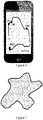
- Figure 3 is a schematic diagram of a regular traveling trajectory diagram generated by a ranging system according to an embodiment of the present invention
- Figure 4 is a schematic diagram of an irregular and continuous traveling trajectory diagram generated by a ranging system according to an embodiment of the present invention.
- the embodiment according to the present invention may measure regular and irregular route continuously and generate the traveling trajectory diagram in real time.
- a holder for fixing the terminal device 3 and connected to the side end of the electronic counter 2 is provided in the ranging apparatus.
- the holder may facilitate the measuring process, maintain a stable signal transmission and avoid the measuring error caused by the angle sensor at the same time.
- the communication module in the ranging apparatus and the terminal device 3 may be wired communication module, such as RS 232, RS485, I2C, SPI or CAN.
- Fig.2 shows that the holder is arranged on the side end of the electronic counter 2, the present invention is not limited thereto; on the contrary the present invention contains all the scope which could stably connect the terminal device 3 to the electronic counter 2.
- Fig. 1 and Fig. 2 shows the scene in which the terminal device 3 is fixed on the ranging apparatus via the holder, but the present invention is not limited thereto. Instead, the terminal device does not have to be fixed on the ranging apparatus to obtain distance information and angle information by the way of wireless communication by using the wireless communication module disposed in the ranging apparatus and the terminal device, the communication way of the wireless communication module is Bluetooth , WIFI, Zigbee or RF communication.
- the storage in the terminal device according to the present invention may be further used to store distance information, angle information and the traveling trajectory diagram generated by the data processing module to facilitate retrieving later.
- the terminal device in the embodiment of the present invention is a smart cellphone, a computer or handheld equipment.
- the data processing module is configured to obtain area of a closed graphic by meshing the closed graphic and calculating the area of the meshes contained by the closed graphic, when the generated traveling trajectory diagram is a closed graphic, so that the actual area of the closed graphic enclosed by the measured trajectory may be obtained.
- the ranging system according to the present invention may further comprise a cloud server, the terminal device and the cloud server are connected to Internet, the cloud server is used for storing and sharing the data sent by the terminal device, the data includes: distance information from the electronic counter, angle information from the angle sensor and/or the generated traveling trajectory diagram and the terminal device is capable of obtaining predesigned traveling trajectory diagram from the cloud server.
- the stored data may be retrieved in real time and the testing data or drawing may be shared with other engineering staff to effectively improve the work quality and efficiency.
- the traveling trajectory generated by the terminal device and uploaded to the cloud server may be the predesigned traveling trajectory diagram to be obtained.
- the terminal device is further provided with a camera
- the data processing module combines the scene image obtained by the camera with the trajectory in the drawing and displays them on the displayer
- the prompt module provides the above-mentioned direction and/or distance prompt on the scene image to indicate the user to correct the traveling route. Additionally, it may be indicated to the user to mark points or lines for the construction site.
- the staff member may mark on the actual work site based on the traveling trajectory in the drawings.
- a traveling trajectory diagram, direction deviation prompt and distance deviation prompt are combined displayed on the scene image, the traveling trajectory diagram herein may be a predesigned traveling trajectory diagram obtained from the cloud server.
- the present invention also provides a ranging method according to claims 11-13.
- the present invention adopts the cooperation of the electronic counter and the angle sensor to generate the drawing of the traveling trajectory, in real time, on the terminal device by using the data measured by the ranging apparatus, which not only achieves the purpose of measuring the distance, but also generates the drawing of the traveling trajectory in real time, and thus the work efficiency is effectively improved;
Landscapes
- Engineering & Computer Science (AREA)
- Radar, Positioning & Navigation (AREA)
- Remote Sensing (AREA)
- Physics & Mathematics (AREA)
- General Physics & Mathematics (AREA)
- Automation & Control Theory (AREA)
- Control Of Position, Course, Altitude, Or Attitude Of Moving Bodies (AREA)
- Navigation (AREA)
- Instructional Devices (AREA)
- Length Measuring Devices By Optical Means (AREA)
- A Measuring Device Byusing Mechanical Method (AREA)
Description
- The present invention relates to the field of surveying and mapping, and more particularly, to a ranging system and a ranging method.
- Currently, people need to use ranging device to measure and plan the route and the area in all aspects of life and work, such as in the field of construction, road engineering, transportation, pipeline laying, landscape areas etc. The most commonly used ranging device is the measuring wheel.
- The existing measuring wheel usually only has the function of ranging, its basic principle is to calculate the number of rotation based on the rolling of the measuring wheel and with the help of mechanical gear counter or electronic counter, so as to realize distance measurement. This method usually only measures the length of the traveling trajectory between two points, and then the drawings need to be plotted one segment by one segment. Thus, this method wastes time and the measurement accuracy is very low. Therefore, only limited function may be achieved in actual use.
-
DE 195 08 264 C1 discloses a method and an apparatus for measuring contours, especially for measuring road.US 2005/219517 A1 discloses a movable light environment measuring system.WO 01/75392 A2 EP 2 796 832 A1US 2009/217542 A1 discloses a measuring device includes a frame, a rolling wheel carried by the frame, measuring means for detennining a distance traveled by the wheel, and signal means responsive to the measuring means for indicating when the wheel has traveled a preselected set distance. The manufacture cost for the measuring apparatus in the above mentioned applications is expensive. - The technical problem solved by the present invention is to provide a ranging system which could achieve ranging function and generate a traveling trajectory diagram in real time simultaneously.
- The preferred embodiments of the present invention could mark the actual scene such as marking line or marking points for a predetermined traveling trajectory on a predesigned drawing, and could prompt direction and distance.
- To achieve the above-mentioned technical purpose, the present invention provides a ranging system according to
independent claim 1 and a ranging method according to independent claim 11. Further embodiments are defined by the dependent claims. - Compared with the prior art, the invention has the advantages that:
- 1. The invention adopts the cooperation of the electronic counter and the angle sensor to generate the drawing of the traveling trajectory, in real time, on the terminal device by using the data measured by the ranging apparatus, which not only achieves the purpose of measuring the distance, but also generates the drawing of the traveling trajectory in real time, and thus the work efficiency is obviously improved;
- 2. The terminal device of the invention is further provided with a camera, and the terminal device could combine the information recorded by the camera with the trajectory on the drawing to complete the work of marking line or points for the construction site, and route correction could be applied in the process of marking;
- 3. The invention has the advantages of simple structure, lightness, flexibility and convenient use.
-
-
Fig. 1 is a schematic structural view of a ranging system according to an embodiment of the present invention; -
Figure 2 is a schematic structural view of a ranging system according to another embodiment of the present invention; -
Figure 3 is a schematic diagram of a regular traveling trajectory diagram generated by a ranging system according to an embodiment of the present invention; -
Figure 4 is a schematic diagram of an irregular and continuous traveling trajectory diagram generated by a ranging system according to an embodiment of the present invention; -
Figure 5 is a schematic diagram illustrating how the ranging system according to the present invention calculates an area of a traveling trajectory by using mesh computing; -
Figure 6 is a schematic diagram illustrating how the ranging system according to an embodiment of the present invention prompts during a traveling process of a measuring wheel; - The invention will now be described in further detail with reference to the accompanying drawings and specific embodiments, which should not be construed as limiting the invention, which is defined by the appended claims.
-
Fig. 1 is a schematic structural view of a ranging system according to an embodiment of the present invention andFig. 2 is a schematic structural view of a ranging system according to another embodiment of the present invention. - As shown in
Fig. 1 , the ranging system according to the present invention comprises a ranging apparatus and aterminal device 3, wherein the ranging apparatus comprises ameasuring wheel 1, a rotating shaft disposed on themeasuring wheel 1, and an electronic counter connected to the rotating shaft and used to obtain distance information of the measuring wheel. A data processing module is provided in theterminal device 3 and communication modules are arranged both on the terminal device and the ranging apparatus, the ranging apparatus or the terminal device further comprises an angle sensor. By using this communication module, the data processing module receives the distance information from the electronic counter and the angle information from the angle sensor, and performs calculation based on the distance information and the angle information to plot, in real time, a first traveling trajectory diagram which the measuring wheel has already traveled on the displayer of the terminal device. In embodiments of the present invention, the angle sensor may be an electronic compass disposed in the ranging apparatus and connected to the communication module of the ranging apparatus, and also may be a gyroscope disposed in the terminal device and connected to the communication module. - The present embodiment adopts the cooperation of the electronic counter and the angle sensor to generate the drawing of the traveling trajectory, in real time, on the terminal device by using the data measured by the ranging apparatus, which not only achieves the purpose of measuring the distance, but also generates the drawing of the traveling trajectory in real time, and thus the work efficiency is effectively improved.
- In one embodiment of the present invention, the ranging system may be used to mark lines or points for the construction site. According to the invention, a predesigned traveling trajectory diagram is stored in a storage of the terminal device, the data processing module is configured to determine current traveling trajectory based on the distance information and the angle information, to monitor the determined current traveling trajectory of the measuring wheel on the basis of the predesigned traveling trajectory, and to output the deviation between the current traveling trajectory and the predesigned traveling trajectory diagram as deviation data when the current traveling trajectory of the measuring wheel deviates from the predesigned traveling trajectory. The deviation data may be, for example, angle and distance data for which the measuring wheel needs to be adjusted from the current location to the predesigned trajectory.
- According to the invention, the terminal device comprises a prompt module which receives the above mentioned deviation data and is configured to perform direction and/or distance prompt based on the deviation data to indicate the user to correct the current traveling route. When the above mentioned predesigned traveling trajectory diagram has marking points or marking lines, the prompt module may prompt or indicate the user to use a separate marker to mark points or lines on the traveling route of the measuring wheel based on the marking points or marking lines.
- In another embodiment of the present invention, the marker is disposed on the ranging apparatus, for example, the marker is connected with the rotating shaft such that the user does not need additional marker, on the contrary, the user could instruct the marker to mark points or lines at the predetermined location when the prompt module prompts that the current location needs to be marked. The marker may also use the data processing module to compare the current traveling trajectory with the predesigned traveling trajectory diagram and if the data processing unit determines that the current location needs to be marked, then the marking instruction is sent to the marker via the communication module, so as to mark points or lines for the measuring site automatically. Referring to
Fig. 2 , inFig. 2 a schematic diagram illustrating that themarker 4 is connected to the rotating shaft of the ranging apparatus is shown. - In the present embodiment, for the predesigned traveling trajectory on the predesigned drawing, marking such as marking lines or points for actual scene can be achieved, and direction and distance are prompted.
-
Figure 3 is a schematic diagram of a regular traveling trajectory diagram generated by a ranging system according to an embodiment of the present invention;Figure 4 is a schematic diagram of an irregular and continuous traveling trajectory diagram generated by a ranging system according to an embodiment of the present invention. As shown inFig. 3 andFig. 4 , the embodiment according to the present invention may measure regular and irregular route continuously and generate the traveling trajectory diagram in real time. - As shown in
Fig. 1 andFig. 2 , a holder for fixing theterminal device 3 and connected to the side end of theelectronic counter 2 is provided in the ranging apparatus. The holder may facilitate the measuring process, maintain a stable signal transmission and avoid the measuring error caused by the angle sensor at the same time. In this situation, the communication module in the ranging apparatus and theterminal device 3 may be wired communication module, such as RS 232, RS485, I2C, SPI or CAN. AlthoughFig.2 shows that the holder is arranged on the side end of theelectronic counter 2, the present invention is not limited thereto; on the contrary the present invention contains all the scope which could stably connect theterminal device 3 to theelectronic counter 2. - Although
Fig. 1 andFig. 2 shows the scene in which theterminal device 3 is fixed on the ranging apparatus via the holder, but the present invention is not limited thereto. Instead, the terminal device does not have to be fixed on the ranging apparatus to obtain distance information and angle information by the way of wireless communication by using the wireless communication module disposed in the ranging apparatus and the terminal device, the communication way of the wireless communication module is Bluetooth , WIFI, Zigbee or RF communication. - The storage in the terminal device according to the present invention may be further used to store distance information, angle information and the traveling trajectory diagram generated by the data processing module to facilitate retrieving later. The terminal device in the embodiment of the present invention is a smart cellphone, a computer or handheld equipment.
- As shown in
Fig. 5 , in an embodiment of the present invention, the data processing module is configured to obtain area of a closed graphic by meshing the closed graphic and calculating the area of the meshes contained by the closed graphic, when the generated traveling trajectory diagram is a closed graphic, so that the actual area of the closed graphic enclosed by the measured trajectory may be obtained. Generally speaking, the smaller the mesh used when meshing the closed graphic is, the higher is the computation accuracy of area of the closed graphic. - The ranging system according to the present invention may further comprise a cloud server, the terminal device and the cloud server are connected to Internet, the cloud server is used for storing and sharing the data sent by the terminal device, the data includes: distance information from the electronic counter, angle information from the angle sensor and/or the generated traveling trajectory diagram and the terminal device is capable of obtaining predesigned traveling trajectory diagram from the cloud server. In this manner, the stored data may be retrieved in real time and the testing data or drawing may be shared with other engineering staff to effectively improve the work quality and efficiency. The traveling trajectory generated by the terminal device and uploaded to the cloud server may be the predesigned traveling trajectory diagram to be obtained.
- According to the invention, the terminal device is further provided with a camera, the data processing module combines the scene image obtained by the camera with the trajectory in the drawing and displays them on the displayer, and the prompt module provides the above-mentioned direction and/or distance prompt on the scene image to indicate the user to correct the traveling route. Additionally, it may be indicated to the user to mark points or lines for the construction site.
- When the predesigned traveling trajectory diagram stored in the terminal device or the cloud server is retrieved, the staff member may mark on the actual work site based on the traveling trajectory in the drawings. Referring to
Fig. 6 , a traveling trajectory diagram, direction deviation prompt and distance deviation prompt are combined displayed on the scene image, the traveling trajectory diagram herein may be a predesigned traveling trajectory diagram obtained from the cloud server. - As mentioned above, the present invention also provides a ranging method according to claims 11-13.
- The present invention adopts the cooperation of the electronic counter and the angle sensor to generate the drawing of the traveling trajectory, in real time, on the terminal device by using the data measured by the ranging apparatus, which not only achieves the purpose of measuring the distance, but also generates the drawing of the traveling trajectory in real time, and thus the work efficiency is effectively improved;
- The described embodiments are merely exemplary embodiments of the present invention and are not intended to limit the scope of the invention as defined in the appended claims. It will be apparent to those skilled in the art that various modifications or equivalent substitutions may be made to the invention within the scope of the invention as defined by the appended claims.
| 1 - Measuring wheel | 2 - Electronic Counter |
| 3- Terminal Device | 4-Marker |
Claims (13)
- A ranging system, characterized in that the ranging system comprises a ranging apparatus and a terminal device (3) wherein the ranging apparatus comprises:a measuring wheel (1),a rotating shaft disposed on the measuring wheel, andan electronic counter (2) connected to the rotating shaft and used to obtain distance information, in real time, of the route which the measuring wheel has already traveled;wherein the ranging apparatus or the terminal device further comprises an angle sensor configured to obtain angle information, in real time, when the measuring wheel is traveling;communication modules are arranged on the terminal device and the ranging apparatus, respectively, to transmit data between the ranging apparatus and the terminal device;the terminal device includes data processing module configured to generate a traveling trajectory diagram of the measuring wheel, in real time, based on the distance information from the electronic counter and the angle information from the angle sensor;the terminal device further comprises a storage configured to store a predesigned traveling trajectory diagram; characterized in that,the data processing module is further configured to monitor, on the basis of the predesigned traveling trajectory diagram, the generated current traveling trajectory of the measuring wheel determined based on the distance information and the angle information, and tooutput deviation data when the generated current traveling trajectory of the measuring wheel deviates from the predesigned traveling trajectory diagram, whereinthe terminal device further comprises a prompt module configured to perform direction and/or distance prompt based on the deviation data to indicate the user to correct the current traveling route of the measuring wheel, wherein theterminal device further comprises a camera configured to obtain, in real time, a scene image in the traveling direction of the measuring wheel, and the prompt module is configured to provide the direction and/or distance prompt on the scene image.
- The ranging system according to claim 1, characterized in that, the prompt module is further configured to indicate the user to mark on the traveling route of the measuring wheel according to the predesigned traveling trajectory diagram.
- The ranging system according to claim 2, characterized in that, the ranging apparatus further comprises a marker configured to mark on the traveling route of the measuring wheel according to the instruction of the user or according to the instruction of the data processing module.
- The ranging system according to claim 1, characterized in that the angle sensor is an electronic compass disposed in the ranging apparatus and connected to the communication module of the ranging apparatus.
- The ranging system according to claim 1, characterized in that the angle sensor is a gyroscope disposed in the terminal device and connected to the data processing module.
- The ranging system according to claim 1, characterized in that, the ranging apparatus further comprises a holder for fixing the terminal device.
- The ranging system according to claim 1, characterized in that the communication module is a wireless communication module or a wired communication module, wherein the interface of the wired communication module is RS232, RS485, I2C, SPI or CAN, and the communication way of the wireless communication module is Bluetooth , WIFI, Zigbee or RF communication.
- The ranging system according to claim 1, characterized in that the ranging system further comprises a cloud server, the terminal device and the cloud server being networked and the cloud server being used for storing and sharing the data sent by the terminal device, and the data sent by the terminal device including: distance information from the electronic counter, angle information from the angle sensor and/or a first traveling trajectory diagram and the terminal device being capable of obtaining predesigned traveling trajectory diagram from the cloud server.
- The ranging system according to claim 1, characterized in that the data processing module is configured to obtain the area of a closed graphic by meshing the closed graphic and calculating the area of the meshes contained by the closed graphic, when the first traveling trajectory diagram is a closed graphic.
- The ranging system according to claim 1, characterized in that, the terminal device is a smart cellphone, a computer or a handheld equipment.
- A ranging method using the ranging system according to any of claims 1-10 comprising an electronic counter obtaining, in real time, distance information which a measuring wheel has already traveled, and an angle sensor obtaining, in real time, angle information of the measuring wheel, when the measuring wheel is traveling; the method comprising the following steps:transmitting the distance information and the angle information to a data processing module;the data processing module generating, in real time, a traveling trajectory diagram of the measuring wheel based on the distance information and the angle information;storing a predesigned traveling trajectory diagram in the terminal device; the data processing module monitoring, on the basis of the predesigned traveling trajectory diagram, the generated current traveling trajectory of the measuring wheel determined based on the distance information and the angle information, and outputting the deviation data when the generated current traveling trajectory deviates from the predesigned traveling trajectory diagram, wherein the ranging method further comprises:
prompting direction and/or distance based on the deviation data to indicate the user to correct the current traveling route of the measuring wheel, and obtaining, with the camera in real time, a scene image in the traveling direction of the measuring wheel, and providing direction and/or distance prompt on the scene image. - The ranging method according to claim 11, wherein the ranging method further comprises: prompting direction and/or distance based on the deviation data to indicate the user to mark on the traveling route of the measuring wheel according to the predesigned traveling trajectory diagram.
- The ranging method according to claim 12, characterized in, a marker disposed in the ranging apparatus marking on the traveling route of the measuring wheel according to the instruction of the user or according to the instruction of the data processing module.
Applications Claiming Priority (2)
| Application Number | Priority Date | Filing Date | Title |
|---|---|---|---|
| CN201510084983.6A CN104634222A (en) | 2015-02-16 | 2015-02-16 | Distance-measuring system and distance-measuring method |
| PCT/CN2015/074461 WO2016131203A1 (en) | 2015-02-16 | 2015-03-18 | Ranging system and ranging method |
Publications (3)
| Publication Number | Publication Date |
|---|---|
| EP3260813A1 EP3260813A1 (en) | 2017-12-27 |
| EP3260813A4 EP3260813A4 (en) | 2018-07-11 |
| EP3260813B1 true EP3260813B1 (en) | 2022-08-10 |
Family
ID=53213247
Family Applications (1)
| Application Number | Title | Priority Date | Filing Date |
|---|---|---|---|
| EP15882342.7A Active EP3260813B1 (en) | 2015-02-16 | 2015-03-18 | Ranging system and ranging method |
Country Status (8)
| Country | Link |
|---|---|
| US (1) | US10473473B2 (en) |
| EP (1) | EP3260813B1 (en) |
| CN (2) | CN104634222A (en) |
| CA (1) | CA2976520C (en) |
| DK (1) | DK3260813T3 (en) |
| ES (1) | ES2929463T3 (en) |
| PT (1) | PT3260813T (en) |
| WO (1) | WO2016131203A1 (en) |
Families Citing this family (29)
| Publication number | Priority date | Publication date | Assignee | Title |
|---|---|---|---|---|
| US11243309B2 (en) | 2015-02-16 | 2022-02-08 | Northwest Instrument Inc. | Ranging system and ranging method |
| US12055414B2 (en) | 2015-02-16 | 2024-08-06 | Northwest Instrument Inc. | Ranging system and ranging method |
| CN105511742B (en) | 2016-01-07 | 2021-10-01 | 美国西北仪器公司 | Intelligent interactive interface |
| CN106289132A (en) * | 2015-06-03 | 2017-01-04 | 中国移动通信集团设计院有限公司 | A kind of range unit and distance-finding method |
| US9803965B2 (en) * | 2015-09-21 | 2017-10-31 | ESTA-mate, LLC | Precise length and area measurements based upon ground-traverse distances and location information |
| CN106813639A (en) * | 2015-11-27 | 2017-06-09 | 美国西北仪器公司 | Multifunctional distance wheel |
| US11556170B2 (en) | 2016-01-07 | 2023-01-17 | Northwest Instrument Inc. | Intelligent interface based on augmented reality |
| WO2017132819A1 (en) * | 2016-02-02 | 2017-08-10 | 美国西北仪器公司 | Ranging system |
| CN107024204B (en) * | 2016-02-02 | 2021-07-30 | 美国西北仪器公司 | Distance measuring system |
| US9964390B2 (en) * | 2016-08-23 | 2018-05-08 | Top Measure Instrument Company | Standable surveyor wheel |
| CN106289075A (en) * | 2016-09-29 | 2017-01-04 | 深圳市迈测科技股份有限公司 | The antidote of geodimeter and system |
| CN106767623B (en) * | 2017-03-20 | 2018-03-13 | 买东城 | Rail digital display rangefinder |
| CN106989737B (en) * | 2017-04-27 | 2019-05-31 | 南京航空航天大学 | A kind of Multifunctional distance device and working method |
| IT201700059286A1 (en) * | 2017-06-05 | 2018-12-05 | Claudio Marsella | AUTOMATED DEVICE FOR LINEAR MEASUREMENT AND METHOD OF USE |
| CN107328397B (en) * | 2017-06-30 | 2019-09-20 | 新沂城北新区城市建设发展有限公司 | One kind turning over ditch measuring wheel |
| CN108195345A (en) * | 2017-12-20 | 2018-06-22 | 合肥英睿系统技术有限公司 | A kind of distance measuring method and system based on electronic imager |
| FR3077130B1 (en) * | 2018-01-23 | 2022-05-13 | Bosch Gmbh Robert | Length measuring device and method |
| CN108520106B (en) | 2018-03-19 | 2022-09-23 | 美国西北仪器公司 | Method and system for space design |
| US11604904B2 (en) | 2018-03-19 | 2023-03-14 | Northwest Instrument Inc. | Method and system for space design |
| US11976955B2 (en) * | 2018-09-21 | 2024-05-07 | Ecolab Usa Inc. | Portable fluid level monitoring device and method |
| CN110779504A (en) * | 2019-11-14 | 2020-02-11 | 徐州市创新科技发展有限公司 | Intelligent geographical mapping device |
| CN110864663B (en) * | 2019-11-26 | 2021-11-16 | 深圳市国测测绘技术有限公司 | House volume measuring method based on unmanned aerial vehicle technology |
| CN110906830B (en) * | 2019-12-17 | 2022-02-11 | 美国西北仪器公司 | Intelligent distance measuring wheel system and distance measuring method thereof |
| CN111055647B (en) * | 2019-12-28 | 2021-03-23 | 芜湖安普机器人产业技术研究院有限公司 | Control system of trolley capable of walking on reducing cambered surface of rotary cement kiln |
| CN112221782A (en) * | 2020-11-05 | 2021-01-15 | 美国西北仪器公司 | Paint spraying assembly for distance measuring wheel |
| CN112371381A (en) * | 2020-11-05 | 2021-02-19 | 美国西北仪器公司 | Method for spraying paint by means of a paint spraying assembly connected with a distance measuring wheel |
| CN112539726A (en) * | 2020-12-25 | 2021-03-23 | 深圳市测友科技有限公司 | Irregular object length measuring instrument |
| CN113295121A (en) * | 2021-06-10 | 2021-08-24 | 广东电网有限责任公司 | Hand-push roller distance measuring instrument, hand-push roller distance measuring instrument monitoring device and distance measuring system |
| CN115859404B (en) * | 2023-02-16 | 2023-05-23 | 威海新城智能科技有限公司 | CAD drawing generation method, device and medium based on ranging wheel measurement data |
Family Cites Families (30)
| Publication number | Priority date | Publication date | Assignee | Title |
|---|---|---|---|---|
| DE4318939A1 (en) * | 1993-05-27 | 1994-12-01 | Muammer Atar | Device for measuring distance by means of a telescopic arm; a steel strip is transported via a toothed wheel |
| DE19508264C1 (en) * | 1995-03-08 | 1996-02-01 | Klose Werner Dipl Ing Fh | Measuring contours, esp. in road surface |
| DE19536597A1 (en) * | 1995-09-19 | 1997-03-27 | Atar Muammer | Device for measuring distance and angle and spacing between steel tapes |
| CN2266123Y (en) * | 1996-04-17 | 1997-10-29 | 高云波 | Crooked road distance measuring implement |
| US6532672B1 (en) * | 2000-03-31 | 2003-03-18 | Joseph S. Gottlieb | Area measurement device and method |
| US6725553B2 (en) * | 2001-01-19 | 2004-04-27 | Donald R. Airey | Contour measuring device and method |
| US6952880B2 (en) * | 2001-08-27 | 2005-10-11 | Hewlett-Packard Development Company, L.P. | Measurement and marking device |
| CN2529198Y (en) * | 2002-03-08 | 2003-01-01 | 捷安特(中国)有限公司 | System for writing riding path locus |
| JP2004294312A (en) * | 2003-03-27 | 2004-10-21 | Toho Gas Co Ltd | Simplified area calculator |
| JP2005291734A (en) * | 2004-03-31 | 2005-10-20 | Univ Nagoya | Measuring apparatus for light environment in forest |
| DE202004015570U1 (en) * | 2004-10-06 | 2004-12-16 | Sick Stegmann Gmbh | measuring device |
| WO2007025063A2 (en) * | 2005-08-24 | 2007-03-01 | Watkins Nathan P | Measuring roller and spray device |
| US20090217542A1 (en) * | 2005-08-24 | 2009-09-03 | Watkins Nathan P | Measuring roller and spray device |
| CN201025441Y (en) * | 2007-02-13 | 2008-02-20 | 桂林迪吉特电子有限公司 | Electronic digital display wheel range finder |
| CN201218721Y (en) * | 2008-06-28 | 2009-04-08 | 桂林迪吉特电子有限公司 | Electronic digital display ranging wheel |
| CN201342230Y (en) * | 2008-12-22 | 2009-11-11 | 邹海南 | Line-drawing range finder |
| CN201463803U (en) * | 2009-04-07 | 2010-05-12 | 任祁 | Improved portable wheel type distance measuring instrument |
| CN201484448U (en) * | 2009-06-05 | 2010-05-26 | 奎龙实业股份有限公司 | Ranging vehicle |
| CN101799547A (en) * | 2010-03-17 | 2010-08-11 | 上海大学 | Photoelectric curve distance meter |
| CN102236030B (en) * | 2010-04-28 | 2013-04-17 | 廖明忠 | Inertial measurement simulation analyzing method, terminal and system |
| CN102506683A (en) * | 2011-09-29 | 2012-06-20 | 林忠仁 | Measuring wheel used for measuring distance and area and measuring method thereof |
| CN102831672B (en) * | 2012-09-03 | 2015-09-02 | 同济汽车设计研究院有限公司 | Intelligent vehicle monitoring system |
| DE102012215754A1 (en) * | 2012-09-05 | 2014-03-06 | Robert Bosch Gmbh | Method and device for vehicle measurement |
| CN202869467U (en) * | 2012-11-18 | 2013-04-10 | 湖南科技学院 | Electronic display distance measuring roller |
| JP6181412B2 (en) * | 2013-04-24 | 2017-08-16 | 株式会社トプコン | Simple distance meter |
| CN103234445A (en) * | 2013-04-28 | 2013-08-07 | 段全新 | Device and method for measuring simple surveying and mapping plane |
| CN203739885U (en) * | 2013-11-29 | 2014-07-30 | 北京恒华伟业科技股份有限公司 | Track control system for line marking vehicle |
| CN104111050B (en) * | 2014-07-23 | 2017-02-08 | 安徽兆尹信息科技股份有限公司 | Distance measurement trolley with linear track monitoring function |
| CN204514232U (en) * | 2015-02-16 | 2015-07-29 | 上海诺司纬光电仪器有限公司 | A kind of range measurement system |
| US9803965B2 (en) * | 2015-09-21 | 2017-10-31 | ESTA-mate, LLC | Precise length and area measurements based upon ground-traverse distances and location information |
-
2015
- 2015-02-16 CN CN201510084983.6A patent/CN104634222A/en active Pending
- 2015-02-16 CN CN202110884383.3A patent/CN113607145A/en active Pending
- 2015-03-18 DK DK15882342.7T patent/DK3260813T3/en active
- 2015-03-18 PT PT158823427T patent/PT3260813T/en unknown
- 2015-03-18 CA CA2976520A patent/CA2976520C/en active Active
- 2015-03-18 US US15/503,222 patent/US10473473B2/en active Active
- 2015-03-18 ES ES15882342T patent/ES2929463T3/en active Active
- 2015-03-18 WO PCT/CN2015/074461 patent/WO2016131203A1/en active Application Filing
- 2015-03-18 EP EP15882342.7A patent/EP3260813B1/en active Active
Also Published As
| Publication number | Publication date |
|---|---|
| EP3260813A1 (en) | 2017-12-27 |
| US10473473B2 (en) | 2019-11-12 |
| CN113607145A (en) | 2021-11-05 |
| PT3260813T (en) | 2022-10-21 |
| CN104634222A (en) | 2015-05-20 |
| ES2929463T3 (en) | 2022-11-29 |
| US20180023962A1 (en) | 2018-01-25 |
| EP3260813A4 (en) | 2018-07-11 |
| DK3260813T3 (en) | 2022-11-07 |
| WO2016131203A1 (en) | 2016-08-25 |
| CA2976520A1 (en) | 2016-08-25 |
| CA2976520C (en) | 2023-07-11 |
Similar Documents
| Publication | Publication Date | Title |
|---|---|---|
| EP3260813B1 (en) | Ranging system and ranging method | |
| US10627201B2 (en) | Ranging system | |
| RU2439497C1 (en) | Automated system of navigation and survey control | |
| CN101526353A (en) | Geographical data collecting device | |
| CN103017740B (en) | Method and system for positioning monitoring target by using video monitoring devices | |
| CN204514232U (en) | A kind of range measurement system | |
| US11237017B2 (en) | Stride length calibration method and system, and related device | |
| CN102288223A (en) | Intelligent tension stringing monitoring device and monitoring method for overhead electric transmission line | |
| US12055414B2 (en) | Ranging system and ranging method | |
| CN107255820A (en) | A kind of laser ranging system | |
| JP2017227463A (en) | Position and attitude determination device | |
| JP2017026411A5 (en) | ||
| CN103499341A (en) | Electric rod dipmeter as well as using method thereof | |
| CN108152838B (en) | Device and method for measuring target position based on sighting | |
| US11243309B2 (en) | Ranging system and ranging method | |
| EP4215871A1 (en) | Ranging system and ranging method | |
| KR101469077B1 (en) | Update system for numerical map using materials acquired from field research | |
| US20200158509A1 (en) | Positioning and navigation systems and methods | |
| CN201983766U (en) | Bridge structure monitoring system | |
| CN207571302U (en) | A kind of unmanned plane topographic survey device | |
| JP2013242180A (en) | Portable radiation measuring device and method of measuring radiation using the same | |
| CN207675158U (en) | One kind being based on anallatic inclination measuring device | |
| KR101200913B1 (en) | Portable land control apparatus | |
| KR101391764B1 (en) | The method of harmonization between inertial navigation system and total station | |
| CN205642352U (en) | Target range unit based on wired gyroplane |
Legal Events
| Date | Code | Title | Description |
|---|---|---|---|
| STAA | Information on the status of an ep patent application or granted ep patent |
Free format text: STATUS: THE INTERNATIONAL PUBLICATION HAS BEEN MADE |
|
| PUAI | Public reference made under article 153(3) epc to a published international application that has entered the european phase |
Free format text: ORIGINAL CODE: 0009012 |
|
| STAA | Information on the status of an ep patent application or granted ep patent |
Free format text: STATUS: REQUEST FOR EXAMINATION WAS MADE |
|
| 17P | Request for examination filed |
Effective date: 20170907 |
|
| AK | Designated contracting states |
Kind code of ref document: A1 Designated state(s): AL AT BE BG CH CY CZ DE DK EE ES FI FR GB GR HR HU IE IS IT LI LT LU LV MC MK MT NL NO PL PT RO RS SE SI SK SM TR |
|
| AX | Request for extension of the european patent |
Extension state: BA ME |
|
| DAV | Request for validation of the european patent (deleted) | ||
| DAX | Request for extension of the european patent (deleted) | ||
| REG | Reference to a national code |
Ref country code: DE Ref legal event code: R079 Ref document number: 602015080311 Country of ref document: DE Free format text: PREVIOUS MAIN CLASS: G01B0005020000 Ipc: G01B0003120000 |
|
| A4 | Supplementary search report drawn up and despatched |
Effective date: 20180608 |
|
| RIC1 | Information provided on ipc code assigned before grant |
Ipc: G01B 3/12 20060101AFI20180604BHEP |
|
| RAP1 | Party data changed (applicant data changed or rights of an application transferred) |
Owner name: NORTHWEST INSTRUMENT INC. Owner name: NORTHWEST INSTRUMENT (SHANGHAI) CO., LTD |
|
| RAP1 | Party data changed (applicant data changed or rights of an application transferred) |
Owner name: NORTHWEST INSTRUMENT INC. |
|
| STAA | Information on the status of an ep patent application or granted ep patent |
Free format text: STATUS: EXAMINATION IS IN PROGRESS |
|
| 17Q | First examination report despatched |
Effective date: 20191007 |
|
| STAA | Information on the status of an ep patent application or granted ep patent |
Free format text: STATUS: EXAMINATION IS IN PROGRESS |
|
| GRAP | Despatch of communication of intention to grant a patent |
Free format text: ORIGINAL CODE: EPIDOSNIGR1 |
|
| STAA | Information on the status of an ep patent application or granted ep patent |
Free format text: STATUS: GRANT OF PATENT IS INTENDED |
|
| INTG | Intention to grant announced |
Effective date: 20220223 |
|
| RIN1 | Information on inventor provided before grant (corrected) |
Inventor name: XING, DAVID Inventor name: SHI, XIN |
|
| GRAS | Grant fee paid |
Free format text: ORIGINAL CODE: EPIDOSNIGR3 |
|
| GRAA | (expected) grant |
Free format text: ORIGINAL CODE: 0009210 |
|
| STAA | Information on the status of an ep patent application or granted ep patent |
Free format text: STATUS: THE PATENT HAS BEEN GRANTED |
|
| AK | Designated contracting states |
Kind code of ref document: B1 Designated state(s): AL AT BE BG CH CY CZ DE DK EE ES FI FR GB GR HR HU IE IS IT LI LT LU LV MC MK MT NL NO PL PT RO RS SE SI SK SM TR |
|
| REG | Reference to a national code |
Ref country code: AT Ref legal event code: REF Ref document number: 1510856 Country of ref document: AT Kind code of ref document: T Effective date: 20220815 Ref country code: CH Ref legal event code: EP |
|
| REG | Reference to a national code |
Ref country code: IE Ref legal event code: FG4D |
|
| REG | Reference to a national code |
Ref country code: DE Ref legal event code: R096 Ref document number: 602015080311 Country of ref document: DE |
|
| REG | Reference to a national code |
Ref country code: PT Ref legal event code: SC4A Ref document number: 3260813 Country of ref document: PT Date of ref document: 20221021 Kind code of ref document: T Free format text: AVAILABILITY OF NATIONAL TRANSLATION Effective date: 20221017 |
|
| REG | Reference to a national code |
Ref country code: DK Ref legal event code: T3 Effective date: 20221031 |
|
| REG | Reference to a national code |
Ref country code: SE Ref legal event code: TRGR |
|
| REG | Reference to a national code |
Ref country code: ES Ref legal event code: FG2A Ref document number: 2929463 Country of ref document: ES Kind code of ref document: T3 Effective date: 20221129 |
|
| REG | Reference to a national code |
Ref country code: NO Ref legal event code: T2 Effective date: 20220810 |
|
| REG | Reference to a national code |
Ref country code: NL Ref legal event code: MP Effective date: 20220810 |
|
| REG | Reference to a national code |
Ref country code: LT Ref legal event code: MG9D |
|
| REG | Reference to a national code |
Ref country code: GR Ref legal event code: EP Ref document number: 20220402131 Country of ref document: GR Effective date: 20221212 |
|
| PG25 | Lapsed in a contracting state [announced via postgrant information from national office to epo] |
Ref country code: RS Free format text: LAPSE BECAUSE OF FAILURE TO SUBMIT A TRANSLATION OF THE DESCRIPTION OR TO PAY THE FEE WITHIN THE PRESCRIBED TIME-LIMIT Effective date: 20220810 Ref country code: NL Free format text: LAPSE BECAUSE OF FAILURE TO SUBMIT A TRANSLATION OF THE DESCRIPTION OR TO PAY THE FEE WITHIN THE PRESCRIBED TIME-LIMIT Effective date: 20220810 Ref country code: LV Free format text: LAPSE BECAUSE OF FAILURE TO SUBMIT A TRANSLATION OF THE DESCRIPTION OR TO PAY THE FEE WITHIN THE PRESCRIBED TIME-LIMIT Effective date: 20220810 Ref country code: LT Free format text: LAPSE BECAUSE OF FAILURE TO SUBMIT A TRANSLATION OF THE DESCRIPTION OR TO PAY THE FEE WITHIN THE PRESCRIBED TIME-LIMIT Effective date: 20220810 |
|
| PG25 | Lapsed in a contracting state [announced via postgrant information from national office to epo] |
Ref country code: PL Free format text: LAPSE BECAUSE OF FAILURE TO SUBMIT A TRANSLATION OF THE DESCRIPTION OR TO PAY THE FEE WITHIN THE PRESCRIBED TIME-LIMIT Effective date: 20220810 Ref country code: IS Free format text: LAPSE BECAUSE OF FAILURE TO SUBMIT A TRANSLATION OF THE DESCRIPTION OR TO PAY THE FEE WITHIN THE PRESCRIBED TIME-LIMIT Effective date: 20221210 Ref country code: HR Free format text: LAPSE BECAUSE OF FAILURE TO SUBMIT A TRANSLATION OF THE DESCRIPTION OR TO PAY THE FEE WITHIN THE PRESCRIBED TIME-LIMIT Effective date: 20220810 |
|
| PG25 | Lapsed in a contracting state [announced via postgrant information from national office to epo] |
Ref country code: SM Free format text: LAPSE BECAUSE OF FAILURE TO SUBMIT A TRANSLATION OF THE DESCRIPTION OR TO PAY THE FEE WITHIN THE PRESCRIBED TIME-LIMIT Effective date: 20220810 Ref country code: RO Free format text: LAPSE BECAUSE OF FAILURE TO SUBMIT A TRANSLATION OF THE DESCRIPTION OR TO PAY THE FEE WITHIN THE PRESCRIBED TIME-LIMIT Effective date: 20220810 |
|
| REG | Reference to a national code |
Ref country code: DE Ref legal event code: R097 Ref document number: 602015080311 Country of ref document: DE |
|
| PG25 | Lapsed in a contracting state [announced via postgrant information from national office to epo] |
Ref country code: SK Free format text: LAPSE BECAUSE OF FAILURE TO SUBMIT A TRANSLATION OF THE DESCRIPTION OR TO PAY THE FEE WITHIN THE PRESCRIBED TIME-LIMIT Effective date: 20220810 Ref country code: EE Free format text: LAPSE BECAUSE OF FAILURE TO SUBMIT A TRANSLATION OF THE DESCRIPTION OR TO PAY THE FEE WITHIN THE PRESCRIBED TIME-LIMIT Effective date: 20220810 |
|
| PLBE | No opposition filed within time limit |
Free format text: ORIGINAL CODE: 0009261 |
|
| STAA | Information on the status of an ep patent application or granted ep patent |
Free format text: STATUS: NO OPPOSITION FILED WITHIN TIME LIMIT |
|
| PG25 | Lapsed in a contracting state [announced via postgrant information from national office to epo] |
Ref country code: AL Free format text: LAPSE BECAUSE OF FAILURE TO SUBMIT A TRANSLATION OF THE DESCRIPTION OR TO PAY THE FEE WITHIN THE PRESCRIBED TIME-LIMIT Effective date: 20220810 |
|
| P01 | Opt-out of the competence of the unified patent court (upc) registered |
Effective date: 20230531 |
|
| 26N | No opposition filed |
Effective date: 20230511 |
|
| PG25 | Lapsed in a contracting state [announced via postgrant information from national office to epo] |
Ref country code: SI Free format text: LAPSE BECAUSE OF FAILURE TO SUBMIT A TRANSLATION OF THE DESCRIPTION OR TO PAY THE FEE WITHIN THE PRESCRIBED TIME-LIMIT Effective date: 20220810 |
|
| REG | Reference to a national code |
Ref country code: AT Ref legal event code: UEP Ref document number: 1510856 Country of ref document: AT Kind code of ref document: T Effective date: 20220810 |
|
| PG25 | Lapsed in a contracting state [announced via postgrant information from national office to epo] |
Ref country code: MC Free format text: LAPSE BECAUSE OF FAILURE TO SUBMIT A TRANSLATION OF THE DESCRIPTION OR TO PAY THE FEE WITHIN THE PRESCRIBED TIME-LIMIT Effective date: 20220810 |
|
| REG | Reference to a national code |
Ref country code: BE Ref legal event code: MM Effective date: 20230331 |
|
| PG25 | Lapsed in a contracting state [announced via postgrant information from national office to epo] |
Ref country code: LU Free format text: LAPSE BECAUSE OF NON-PAYMENT OF DUE FEES Effective date: 20230318 |
|
| PG25 | Lapsed in a contracting state [announced via postgrant information from national office to epo] |
Ref country code: BE Free format text: LAPSE BECAUSE OF NON-PAYMENT OF DUE FEES Effective date: 20230331 |
|
| PGFP | Annual fee paid to national office [announced via postgrant information from national office to epo] |
Ref country code: GR Payment date: 20240320 Year of fee payment: 10 |
|
| PGFP | Annual fee paid to national office [announced via postgrant information from national office to epo] |
Ref country code: IE Payment date: 20240321 Year of fee payment: 10 |
|
| PGFP | Annual fee paid to national office [announced via postgrant information from national office to epo] |
Ref country code: AT Payment date: 20240321 Year of fee payment: 10 |
|
| PGFP | Annual fee paid to national office [announced via postgrant information from national office to epo] |
Ref country code: FI Payment date: 20240320 Year of fee payment: 10 Ref country code: DE Payment date: 20240320 Year of fee payment: 10 Ref country code: CZ Payment date: 20240311 Year of fee payment: 10 Ref country code: GB Payment date: 20240320 Year of fee payment: 10 Ref country code: PT Payment date: 20240312 Year of fee payment: 10 |
|
| PGFP | Annual fee paid to national office [announced via postgrant information from national office to epo] |
Ref country code: TR Payment date: 20240312 Year of fee payment: 10 Ref country code: SE Payment date: 20240320 Year of fee payment: 10 Ref country code: NO Payment date: 20240322 Year of fee payment: 10 Ref country code: IT Payment date: 20240329 Year of fee payment: 10 Ref country code: FR Payment date: 20240328 Year of fee payment: 10 Ref country code: DK Payment date: 20240326 Year of fee payment: 10 |
|
| PGFP | Annual fee paid to national office [announced via postgrant information from national office to epo] |
Ref country code: CH Payment date: 20240401 Year of fee payment: 10 |
|
| PGFP | Annual fee paid to national office [announced via postgrant information from national office to epo] |
Ref country code: ES Payment date: 20240429 Year of fee payment: 10 |