EP2965040B1 - Pyramid mapping data structure for indoor navigation - Google Patents
Pyramid mapping data structure for indoor navigation Download PDFInfo
- Publication number
- EP2965040B1 EP2965040B1 EP14713344.1A EP14713344A EP2965040B1 EP 2965040 B1 EP2965040 B1 EP 2965040B1 EP 14713344 A EP14713344 A EP 14713344A EP 2965040 B1 EP2965040 B1 EP 2965040B1
- Authority
- EP
- European Patent Office
- Prior art keywords
- map
- level
- pois
- poi
- data structure
- Prior art date
- Legal status (The legal status is an assumption and is not a legal conclusion. Google has not performed a legal analysis and makes no representation as to the accuracy of the status listed.)
- Not-in-force
Links
Images


Classifications
-
- G—PHYSICS
- G01—MEASURING; TESTING
- G01C—MEASURING DISTANCES, LEVELS OR BEARINGS; SURVEYING; NAVIGATION; GYROSCOPIC INSTRUMENTS; PHOTOGRAMMETRY OR VIDEOGRAMMETRY
- G01C21/00—Navigation; Navigational instruments not provided for in groups G01C1/00 - G01C19/00
- G01C21/26—Navigation; Navigational instruments not provided for in groups G01C1/00 - G01C19/00 specially adapted for navigation in a road network
- G01C21/34—Route searching; Route guidance
- G01C21/36—Input/output arrangements for on-board computers
- G01C21/3679—Retrieval, searching and output of POI information, e.g. hotels, restaurants, shops, filling stations, parking facilities
- G01C21/3682—Retrieval, searching and output of POI information, e.g. hotels, restaurants, shops, filling stations, parking facilities output of POI information on a road map
-
- G—PHYSICS
- G01—MEASURING; TESTING
- G01C—MEASURING DISTANCES, LEVELS OR BEARINGS; SURVEYING; NAVIGATION; GYROSCOPIC INSTRUMENTS; PHOTOGRAMMETRY OR VIDEOGRAMMETRY
- G01C21/00—Navigation; Navigational instruments not provided for in groups G01C1/00 - G01C19/00
- G01C21/20—Instruments for performing navigational calculations
- G01C21/206—Instruments for performing navigational calculations specially adapted for indoor navigation
-
- G—PHYSICS
- G01—MEASURING; TESTING
- G01C—MEASURING DISTANCES, LEVELS OR BEARINGS; SURVEYING; NAVIGATION; GYROSCOPIC INSTRUMENTS; PHOTOGRAMMETRY OR VIDEOGRAMMETRY
- G01C21/00—Navigation; Navigational instruments not provided for in groups G01C1/00 - G01C19/00
- G01C21/38—Electronic maps specially adapted for navigation; Updating thereof
- G01C21/3804—Creation or updating of map data
- G01C21/3807—Creation or updating of map data characterised by the type of data
- G01C21/3811—Point data, e.g. Point of Interest [POI]
-
- G—PHYSICS
- G01—MEASURING; TESTING
- G01C—MEASURING DISTANCES, LEVELS OR BEARINGS; SURVEYING; NAVIGATION; GYROSCOPIC INSTRUMENTS; PHOTOGRAMMETRY OR VIDEOGRAMMETRY
- G01C21/00—Navigation; Navigational instruments not provided for in groups G01C1/00 - G01C19/00
- G01C21/38—Electronic maps specially adapted for navigation; Updating thereof
- G01C21/3863—Structures of map data
- G01C21/3867—Geometry of map features, e.g. shape points, polygons or for simplified maps
-
- G—PHYSICS
- G01—MEASURING; TESTING
- G01C—MEASURING DISTANCES, LEVELS OR BEARINGS; SURVEYING; NAVIGATION; GYROSCOPIC INSTRUMENTS; PHOTOGRAMMETRY OR VIDEOGRAMMETRY
- G01C21/00—Navigation; Navigational instruments not provided for in groups G01C1/00 - G01C19/00
- G01C21/38—Electronic maps specially adapted for navigation; Updating thereof
- G01C21/3863—Structures of map data
- G01C21/387—Organisation of map data, e.g. version management or database structures
- G01C21/3878—Hierarchical structures, e.g. layering
-
- G—PHYSICS
- G06—COMPUTING OR CALCULATING; COUNTING
- G06T—IMAGE DATA PROCESSING OR GENERATION, IN GENERAL
- G06T11/00—Two-dimensional [2D] image generation
- G06T11/20—Drawing from basic elements
Definitions
- Embodiments of the present invention relate to a method and architecture for creating and using multi-level geometry for indoor maps with different level of details.
- Electronic devices have become a part of everyday life. Small computing devices are now placed in everything from automobiles to housing locks. The complexity of electronic devices has increased dramatically in the last few years. For example, many electronic devices have one or more processors that help control the device, as well as a number of digital circuits to support the processor and other parts of the device.
- an earth map is stored as hierarchical tiles in image format. Tiles are predefined and static and are at different resolution. Zoom level and location defines what tiles to take to compose the images on the screen. This format reduces the latency of getting the most relevant information for the user. However, such standards do not exist yet for indoor maps.
- GML Geography Markup Language
- OAC OpenGIS Consortium
- GML maps e.g. Destination Maps XML, by NAVTEQ® GML
- POIs Points of Interest
- Document US2008/0016472 A1 discloses an interactive geographic information system server that provides only a subset of the overall database to a mapping module at a client terminal, by converting complex polygon data of buildings to simplified polygon data at different, hierarchical, levels of detail.
- the hierarchical map data structure is, however, not based on POI types received from a user.
- An embodiment is directed to generating a polygon representation of a plurality of points of interest (POIs) in a scene having a corresponding base level map of the scene, and creating a new level map including a reduced number of polygon representations of POIs on the basis of elimination of POIs having a lower than specified POI importance level.
- a mobile device e.g., the user device
- a method for creating and using multi-level geometry for indoor maps with different levels of detail. With a multi-level hierarchical structure from coarse to fine, this method can adjust the complexity of geometry loaded in mobile devices for display according to the context and resolution or zoom level. It may also reduce the latency and power consumption of map loading and information display as a result of the reduced volume of data received by or transmitted from the mobile device.
- CDMA Code Division Multiple Access
- TDMA Time Division Multiple Access
- FDMA Frequency Division Multiple Access
- OFDMA Orthogonal FDMA
- SC-FDMA Single-Carrier FDMA
- a CDMA network may implement a radio technology such as Universal Terrestrial Radio Access (UTRA), CDMA2000, etc.
- UTRA includes Wideband CDMA (W-CDMA).
- CDMA2000 covers IS-2000, IS-95 and technology such as Global System for Mobile Communication (GSM).
- GSM Global System for Mobile Communication
- An OFDMA network may implement a radio technology such as Evolved UTRA (E-UTRA), the Institute of Electrical and Electronics Engineers (IEEE) 802.11, IEEE 802.16, IEEE 802.20, Flash-OFDAM®, etc.
- E-UTRA Evolved UTRA
- IEEE Institute of Electrical and Electronics Engineers
- GSM Global System for Mobile Communications
- LTE Long Term Evolution
- UTRA, E-UTRA, GSM, UMTS, and LTE are described in documents from an organization named "3 rd Generation Partnership Project” (3GPP).
- CDMA2000 is described in documents from an organization named "3 rd Generation Partnership Project 2" (3GPP2).
- LTE Long Term Evolution
- LTE terminology is used by way of illustration and the scope of the disclosure is not limited to LTE.
- the techniques described herein may be utilized in various application involving wireless transmissions, such as personal area networks (PANs), body area networks (BANs), location, Bluetooth, GPS, UWB, RFID, and the like. Further, the techniques may also be utilized in wired systems, such as cable modems, fiber-based systems, and the like.
- SC-FDMA Single carrier frequency division multiple access
- SC-FDMA signal may have lower peak-to-average power ration (PAPR) because of its inherent single carrier structure.
- PAPR peak-to-average power ration
- SC-FDMA may be used in the uplink communications where the lower PAPR greatly benefits the mobile terminal in terms of transmit power efficiency.
- FIG. 1 illustrates a wireless system 100 that may include a plurality of mobile stations 108, a plurality of base stations 110, a base station controller (BSC) 106, and a mobile switching center (MSC) 102.
- the wireless system 100 may be GSM, EDGE, WCDMA, CDMA, etc.
- the MSC 102 may be configured to interface with a public switched telephone network (PTSN) 104.
- the MSC 102 may also be configured to interface with the BSC 106.
- Each base station 110 may include at least one sector, where each sector may have an omnidirectional antenna or an antenna pointed in a particular direction radially away from the base stations 110. Alternatively, each sector may include two antennas for diversity reception.
- Each base station 110 may be designed to support a plurality of frequency assignments. The intersection of a sector and a frequency assignment may be referred to as a channel.
- the mobile stations 108 may include cellular or portable communication
- the base stations 110 may receive sets of reverse link signals from sets of mobile stations 108.
- the mobile stations 108 may be involved in telephone calls or other communications.
- Each reverse link signal received by a given base station 110 may be processed within that base station 110.
- the resulting data may be forwarded to the BSC 106.
- the BSC 106 may provide call resource allocation and mobility management functionality including the orchestration of soft handoffs between base stations 110.
- the BSC 106 may also route the received data to the MSC 102, which provides additional routing services for interfacing with the PSTN 104.
- the PTSN 104 may interface with the MSC 102
- the MSC 102 may interface with the BSC 106, which in turn may control the base stations 110 to transmit sets of forward link signals to sets of mobile stations 108.
- An indoor map includes, for example a data structure of geometry of features (e.g., offices, elevators, restaurants, which may be referred to as points of interest (POI)) as a list of objects, such as polygons, for example, indicating one or more of location, size, name, etc. This may constitute the base layer of a "map pyramid."
- the geometry of the map may be simplified, for example, to show only a region of the indoor map (e.g., a floor, a part of a floor, type of POI, etc.). Polygons, lines and other geometrical features and/or less important POIs may be removed from the layer.
- the POIs of interest are, e.g., law offices, all other features may be removed. If the POIs are related to safety and evacuation, only stairwells, exit doors, elevators, service shafts, etc., may be retained and offices may be removed.
- An indoor map data structure is the core data in indoor navigation applications. Maps are formatted and stored in multi-level geometry pyramid structure from fine to coarse and from dense to thin. An application accessed by the user selects the most appropriate level from the map pyramid structure to display. The selection is based on a group of criteria including, but not limited to, one or more of the screen size of the device, the degree of zoom-in for a desired level of detail from user's input, the battery level, etc.
- the multi-level map geometry pyramid allows flexible display for various devices. Thus, a user may select a display with minimal detail to achieve fast data transfer with adequate navigation information, select more detail to provide more accurate geographical imaging and meta information about one or more POIs, or some intermediate level of detail. Thus, level selection in map display is driven by device constraints as well as by user need for detail, such as navigation to POIs. This mechanism is useful for widespread implementation on mobile phones for indoor navigation.
- the map generation may take place on a remote server, in which the user provides search input from the mobile device to the server, and a reduced set of information from the base level of the data structure is used to generate a map at a higher level that is less dense with data.
- the process of reducing complexity and data content i.e., paring the data structure to a sub-structure
- the importance of a POI may be measured with a score that depends on the user's search key words and the area of bounding polygon of a POI.
- a server measures the importance score of each POI, merges small neighboring POIs into a complex-POI (or a POI group) with low importance score to create a larger bounding polygon to increase the importance score.
- a POI or complex-POI is chosen to be sent to the mobile device for display if its importance score is above a certain threshold.
- An embodiment of the invention is directed to creating a group of indoor maps at multiple levels of detail according to POI search, and integrating the data structures into a map file in a pyramidal organization that may be accessed by a mobile device application.
- the map file may be stored remotely at the server, or one or more maps may be transmitted for storage on the mobile device.
- the map file may include organization of the geometry of the scene.
- each destination, or point of interest, (POI) in the scene may be described by a polygon line.
- the location (position) of the POI may be derived from actual geographical data (e.g., latitude and longitude), or in a self-defined coordinate system (e.g., where all position data are normalized to a bounding area), which may be computed offline and stored.
- a POI may be represented by a simple polygon for the purpose of showing general location and an indication of size of the POI.
- the polygon representation may be complicated, in order to more accurately portray the physical layout of the POI.
- the polygon representation chosen may be normalized to scale within the bounding area (such as the property limits of a mall or department store), or they may be displayed as oversized to emphasize the POI in the display.
- FIG. 2 illustrates a method 200 of generating a display map based on a pyramid hierarchical reduction of data from a base map data structure.
- a base level data structure of an indoor map is provided, containing the geometry of the indoor environment.
- the data structure includes all geometric details for features of all possible POIs, such as a mall, department store, office building, etc., and which may be stored as a file on a remote server.
- a list of line loops or coordinate points for POIs in the scene is generated to define a polygon representing each POI.
- the polygon may be complex enough to provide a recognizable rendering of a POI (e.g., the layout of a restaurant or department store in a mall), however, an aspect of the disclosure is to provide a map with at least a threshold amount of detail for permitting location and navigation to the POI by providing a reduced amount of data over a communications network to the user mobile device.
- POIs Point of interest
- the POIs may be represented, for example, by simple polygon approximations, cross-hairs, "pins,” etc. depending on the size of the POI relative to the level of resolution of the map.
- a base level map as a data structure may be created - the "base" of a pyramid - that may include a set of possible indoor features of the environment of a property of interest.
- polygon representations of POIs may be accurate to some standard level of detail (e.g., on the scale of 1 ft. increments, or larger) and stored in the base level of the pyramid data structure, but which may not be practically displayed at this level of detail, depending on the resolution of the display device (i.e., a feature of the polygon would have to be greater than one display pixel to be displayable). Metadata describing properties of the POI may also be included at this level.
- the base level data structure may be stored on a server remote from mobile device.
- the base level data structure, or parts of it may be downloaded to and maintained on the mobile device, where the downloaded portions of the data structure may be locally processed.
- a user interacting with the mobile device may specify one or more points of interest.
- the user may be a consumer searching for all shoe vendors in a shopping mall, or a safety inspection officer searching for all fire extinguisher and sprinkler shut-off control valve locations.
- the POI level of interest represents a list of features of interest to the user, which may be transmitted to the server (if such data has not been downloaded to the mobile device).
- the user application on the mobile device thus generates a list of data types (POIs), which may be transmitted to the remote server, for generation of a reduced (“thinned" or "child”) data structure from which a map of reduced complexity may be constructed.
- POIs data types
- the list of POIs corresponding to the specified user input may be used, in method block 240, to create a higher level data structure, from which a map may be constructed, to simplify the map geometry by including only the specified POIs, or types of POIs, of sufficient interest, and removing others of lesser interest.
- the geometry of indoor objects may be simplified in various ways according to various criteria and/or level of importance. For example, line segments with joint angles that are close to 180 degree and adjoining parallel lines may be recursively collapsed. The angle threshold for collapsing line segments may be preset. This renders a map that may be composed from the POI list with less clutter from features of little or no interest to the user. In some cases two or more POIs may be adjacent, or may be related.
- the child data structure may be transmitted to the mobile device, which is adapted to create a map with a user application and information in the child data structure.
- the simplified map may be constructed at the server, and transmitted to the mobile device using less bandwidth or transmission time.
- decision block 250 a determination is made, based on user response or, concurrently, on the context of the search for POIs, whether the level of detail is satisfactory for the user to locate one or more POIs. If the user decides, for example, that the search should be made further selective, such as seeking only "women's shoes," the method may resume at method block 230, where the POI level of interest is more narrowly specified. Alternatively, the user may wish to broaden the interest to locate vendors of both women's shoes and handbags, and the method continues until the level of detail is satisfactorily achieved in decision block 250. Similarly, a plurality of eateries in a food court may be collapsed into a single object, such as a "food court.”
- the mobile device assembles a data structure (whether from internally stored data or from the remote server) to construct a map for display (method block 260) based on the level of detail required to satisfy the interest level for the specified POIs.
- a map file may be stored on a remote server or processor.
- the mobile device parses the map pyramid data from the file and dynamically chooses the most appropriate level of map to display. The selection of the most appropriate map level is based on a group of criteria, which may include the screen size, screen resolution, current zoom-in level, and/or battery level.
- the map level may be constructed at the remote server or processor to contain only the features that permit navigation when displayed on the mobile device.
- navigation from a mall entrance to a particular store or food court may show a skeletal plan of the mall with the location of the mobile device and the destination location, with a line connector showing a path between them.
- the relevant walkway and the POI may be shown, but all other features may be absent from the displayed map, the consequence of which is a display with reduced data content that required a reduced amount of broadcast bandwidth and receiver stored energy to display relative to a fully detailed map.
- Map information is stored in a multilevel hierarchical structure from coarse to fine. For example, at higher levels (i.e., large overview displays, as in a parent node in XML), some structures may be merged or ignored.
- a food court may be formed as a data feature without indicating individual restaurants or food service counters, or a department store may be represented as a single entity without specifying/displaying individual departments.
- structures may be described in more detail, e.g. with small line segments and polygons, and including metadata describing the POI structure.
- Data may be requested from a higher level in the pyramid by the mobile device to reduce the amount of data sent to the mobile device. For example, a display pertaining only to a food court may show individual dining services, or in a department store, the location of various departments.
- the displayed map includes less than the maximum available data from the parent data structure. This has the advantage of requiring less data to be received by the mobile device and requires less power to process the thinner ("child") data structure and provide a simpler map without features that are of lesser or no interest.
- the user may then seek directions to navigate (method block 270) from a current location to one or more of the remaining POIs.
- the result is that far less data, processing time and battery energy are required to serve the user with the desired functionality.
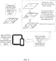
- FIG. 3 illustrates graphically the method described in FIG. 2 .
- An indoor map of geometry data of all POIs represented, for example, as a list of polygons is provided as a parent data structure.
- a base level map may be constructed to include a set of POIs.
- a new level of child data structure, simplified by the absence of unimportant POIs is formed, from which a simplified map may be formed.
- the process may be repeated for a narrower definition of POIs searched until a "top level" is reached, in which only the required POI locations are left to form a map.
- the application on the mobile device may then choose the level of map that is most appropriate to display, based on satisfying the criteria for including the POIs with sufficient level of importance according to the specified level of interest.
- the reduced data structure of geometric data may be stored in a map file for faster retrieval and processing on the mobile device than may be done with the parent data structure to quickly and efficiently produce a simple and useful map, containing only features necessary for a given navigation task.
- Map rendering is one of the most energy-costly parts in indoor navigation related applications on mobile devices. The cost is roughly proportional to the complexity of the scene geometry. It may be appreciated that the disclosed method can reduce the energy consumption and extend the battery life for mobile indoor navigation by rendering and loading maps from a remote server with the most appropriate level of geometry detail required for a task, such as navigating. Furthermore, display quality may be improved by rendering fewer geometric objects on the display, and reducing aliasing.
- DSP digital signal processor
- ASIC application specific integrated circuit
- FPGA field programmable gate array
- a general purpose processor may be a microprocessor, but in the alternative, the processor may be any conventional processor, controller, microcontroller, or state machine.
- a processor may also be implemented as a combination of computing devices, e.g., a combination of a DSP and a microprocessor, a plurality of microprocessors, one or more microprocessors in conjunction with a DSP core, or any other such configuration.
- a software module may reside in RAM memory, flash memory, ROM memory, EPROM memory, EEPROM memory, registers, hard disk, a removable disk, a CD-ROM, or any other form of storage medium known in the art.
- An exemplary storage medium is coupled to the processor such that the processor can read information from, and write information to, the storage medium.
- the storage medium may be integral to the processor.
- the processor and the storage medium may reside in an ASIC.
- the ASIC may reside in a user terminal (e.g., UE).
- the processor and the storage medium may reside as discrete components in a user terminal.
- the functions described may be implemented in hardware, software, firmware, or any combination thereof. If implemented in software, the functions may be stored on or transmitted over as one or more instructions or code on a computer-readable medium.
- Computer-readable media includes both computer storage media and communication media including any medium that facilitates transfer of a computer program from one place to another.
- a storage media may be any available media that can be accessed by a computer.
- such computer-readable media can comprise RAM, ROM, EEPROM, CD-ROM or other optical disk storage, magnetic disk storage or other magnetic storage devices, or any other medium that can be used to carry or store desired program code in the form of instructions or data structures and that can be accessed by a computer.
- any connection is properly termed a computer-readable medium.
- the software is transmitted from a website, server, or other remote source using a coaxial cable, fiber optic cable, twisted pair, digital subscriber line (DSL), or wireless technologies such as infrared, radio, and microwave
- the coaxial cable, fiber optic cable, twisted pair, DSL, or wireless technologies such as infrared, radio, and microwave are included in the definition of medium.
- Disk and disc includes compact disc (CD), laser disc, optical disc, digital versatile disc (DVD), floppy disk and blu-ray disc where disks usually reproduce data magnetically, while discs reproduce data optically with lasers. Combinations of the above should also be included within the scope of computer-readable media.
Landscapes
- Engineering & Computer Science (AREA)
- Radar, Positioning & Navigation (AREA)
- Remote Sensing (AREA)
- Physics & Mathematics (AREA)
- General Physics & Mathematics (AREA)
- Automation & Control Theory (AREA)
- Geometry (AREA)
- Databases & Information Systems (AREA)
- Theoretical Computer Science (AREA)
- Navigation (AREA)
- Instructional Devices (AREA)
Applications Claiming Priority (2)
| Application Number | Priority Date | Filing Date | Title |
|---|---|---|---|
| US13/791,079 US20140257687A1 (en) | 2013-03-08 | 2013-03-08 | Pyramid mapping data structure for indoor navigation |
| PCT/US2014/021589 WO2014138538A1 (en) | 2013-03-08 | 2014-03-07 | Pyramid mapping data structure for indoor navigation |
Publications (2)
| Publication Number | Publication Date |
|---|---|
| EP2965040A1 EP2965040A1 (en) | 2016-01-13 |
| EP2965040B1 true EP2965040B1 (en) | 2017-08-02 |
Family
ID=50389546
Family Applications (1)
| Application Number | Title | Priority Date | Filing Date |
|---|---|---|---|
| EP14713344.1A Not-in-force EP2965040B1 (en) | 2013-03-08 | 2014-03-07 | Pyramid mapping data structure for indoor navigation |
Country Status (6)
| Country | Link |
|---|---|
| US (1) | US20140257687A1 (enExample) |
| EP (1) | EP2965040B1 (enExample) |
| JP (1) | JP2016512342A (enExample) |
| KR (1) | KR20150122791A (enExample) |
| CN (1) | CN105026889B (enExample) |
| WO (1) | WO2014138538A1 (enExample) |
Families Citing this family (15)
| Publication number | Priority date | Publication date | Assignee | Title |
|---|---|---|---|---|
| US20150095350A1 (en) * | 2013-09-30 | 2015-04-02 | Qualcomm Incorporated | Methods, apparatuses, and devices for generating maps on a mobile device |
| US10007677B1 (en) * | 2014-12-04 | 2018-06-26 | Google Llc | System and method for geospatial indexing |
| US10244241B2 (en) * | 2015-03-22 | 2019-03-26 | Innova Plex, Inc. | Pyramidal file structure and method of use thereof |
| CN107315577A (zh) * | 2016-04-26 | 2017-11-03 | 斑马网络技术有限公司 | 业务处理方法、装置、终端设备和用户界面系统 |
| CN107315749B (zh) * | 2016-04-26 | 2021-02-02 | 斑马网络技术有限公司 | 媒体处理方法、装置、设备和系统 |
| US10129698B2 (en) | 2016-07-14 | 2018-11-13 | United Parcel Service Of America, Inc. | Internal location address and automatic routing of intra-facility movement |
| EP3607268B1 (en) | 2017-06-02 | 2022-11-09 | Apple Inc. | Venues map application and system |
| US10769836B2 (en) * | 2017-12-27 | 2020-09-08 | Industrial Technology Research Institute | Method and apparatus for establishing coordinate system and data structure product |
| CN109978944B (zh) * | 2017-12-27 | 2021-06-18 | 财团法人工业技术研究院 | 坐标系统制定方法、装置及数据结构产品 |
| JP6873960B2 (ja) * | 2018-09-27 | 2021-05-19 | 株式会社日立製作所 | 地図データ高詳細度化システム、そのサーバ、及びその方法 |
| WO2020074326A1 (en) * | 2018-10-09 | 2020-04-16 | Tomtom Global Content B.V. | Method, apparatus and computer program for generating map data |
| KR20220146064A (ko) | 2021-04-23 | 2022-11-01 | 주식회사 소프트식스 | 사용자 맞춤형 전자지도 정보 제공 시스템 |
| US12152886B2 (en) * | 2022-01-11 | 2024-11-26 | Ally Financial Inc. | Techniques for indoor wayfinding |
| US12314667B2 (en) * | 2022-01-20 | 2025-05-27 | Zoom Communications, Inc. | Intelligent topic segmentation within a communication session |
| CN115437375B (zh) * | 2022-08-26 | 2024-05-24 | 上海海洋大学 | 一种基于大数据平台分布式瓦片金字塔的三维路径规划方法 |
Family Cites Families (27)
| Publication number | Priority date | Publication date | Assignee | Title |
|---|---|---|---|---|
| US7197500B1 (en) * | 1996-10-25 | 2007-03-27 | Navteq North America, Llc | System and method for use and storage of geographic data on physical media |
| JP2000293099A (ja) * | 1999-04-09 | 2000-10-20 | Toyota Motor Corp | 地図データベース |
| US6571169B2 (en) * | 2001-03-16 | 2003-05-27 | Alpine Electronics, Inc. | Destination input method in navigation system and navigation system |
| AU2003228329A1 (en) * | 2002-03-15 | 2003-09-29 | Summus, Inc. | Methods and systems for downloading and viewing maps |
| JP4192731B2 (ja) * | 2003-09-09 | 2008-12-10 | ソニー株式会社 | 案内情報提供装置及びプログラム |
| EP1668481A2 (en) * | 2003-09-22 | 2006-06-14 | Koninklijke Philips Electronics N.V. | Navigating through a displayed hierarchical data structure |
| US7343378B2 (en) * | 2004-03-29 | 2008-03-11 | Microsoft Corporation | Generation of meaningful names in flattened hierarchical structures |
| JP4713243B2 (ja) * | 2005-06-27 | 2011-06-29 | パイオニア株式会社 | 交通規制情報のデータ構造、それを生成する情報生成装置、その生成方法、地図情報のデータ構造、地図情報を記録した記録媒体、および、案内誘導装置 |
| US7965902B1 (en) * | 2006-05-19 | 2011-06-21 | Google Inc. | Large-scale image processing using mass parallelization techniques |
| WO2007146967A2 (en) * | 2006-06-12 | 2007-12-21 | Google Inc. | Markup language for interactive geographic information system |
| JP5334863B2 (ja) * | 2007-11-27 | 2013-11-06 | 三菱電機株式会社 | 地図情報処理装置および地図情報のデータ構造 |
| US8077918B2 (en) * | 2008-08-28 | 2011-12-13 | Google, Inc. | Architectures and methods for creating and representing time-dependent imagery |
| US20100100548A1 (en) * | 2008-10-16 | 2010-04-22 | Curators Of The University Of Missouri | Storing change features detected from high-resolution, remotely sensed imagery |
| CN101400138B (zh) * | 2008-10-28 | 2010-06-16 | 北京大学 | 一种面向移动设备的地图数据精简方法 |
| WO2010105714A1 (en) * | 2009-03-16 | 2010-09-23 | Tele Atlas B.V. | Method for updating digital maps using altitude information |
| US8335990B2 (en) * | 2009-08-18 | 2012-12-18 | Nokia Corporation | Method and apparatus for grouping points-of-interest on a map |
| US9710961B2 (en) * | 2009-09-17 | 2017-07-18 | Nokia Technologies Oy | Method and apparatus for providing contextual rendering of a map |
| US8565790B2 (en) * | 2010-01-22 | 2013-10-22 | Qualcomm Incorporated | Methods and apparatuses for determining if access to a region is feasible or infeasible for a user of a mobile device |
| US9389085B2 (en) * | 2010-01-22 | 2016-07-12 | Qualcomm Incorporated | Map handling for location based services in conjunction with localized environments |
| US8340415B2 (en) * | 2010-04-05 | 2012-12-25 | Microsoft Corporation | Generation of multi-resolution image pyramids |
| US8665266B2 (en) * | 2010-06-23 | 2014-03-04 | The United States Of America, As Represented By The Secretary Of The Navy | Global visualization process terrain database builder |
| US8488870B2 (en) * | 2010-06-25 | 2013-07-16 | Qualcomm Incorporated | Multi-resolution, multi-window disparity estimation in 3D video processing |
| EP2420799B1 (en) * | 2010-08-18 | 2015-07-22 | Harman Becker Automotive Systems GmbH | Method and system for displaying points of interest |
| US8223172B1 (en) * | 2011-09-26 | 2012-07-17 | Google Inc. | Regional map zoom tables |
| US9173069B2 (en) * | 2012-01-12 | 2015-10-27 | Google Inc. | Navigating using an indoor map representation |
| US9041736B2 (en) * | 2012-06-05 | 2015-05-26 | Apple Inc. | Method, system and apparatus for rendering a map according to a stylesheet |
| US9235906B2 (en) * | 2012-06-10 | 2016-01-12 | Apple Inc. | Scalable processing for associating geometries with map tiles |
-
2013
- 2013-03-08 US US13/791,079 patent/US20140257687A1/en not_active Abandoned
-
2014
- 2014-03-07 WO PCT/US2014/021589 patent/WO2014138538A1/en not_active Ceased
- 2014-03-07 JP JP2015561693A patent/JP2016512342A/ja active Pending
- 2014-03-07 CN CN201480010867.3A patent/CN105026889B/zh not_active Expired - Fee Related
- 2014-03-07 EP EP14713344.1A patent/EP2965040B1/en not_active Not-in-force
- 2014-03-07 KR KR1020157027411A patent/KR20150122791A/ko not_active Withdrawn
Non-Patent Citations (1)
| Title |
|---|
| None * |
Also Published As
| Publication number | Publication date |
|---|---|
| KR20150122791A (ko) | 2015-11-02 |
| CN105026889A (zh) | 2015-11-04 |
| WO2014138538A1 (en) | 2014-09-12 |
| EP2965040A1 (en) | 2016-01-13 |
| CN105026889B (zh) | 2018-05-29 |
| JP2016512342A (ja) | 2016-04-25 |
| US20140257687A1 (en) | 2014-09-11 |
Similar Documents
| Publication | Publication Date | Title |
|---|---|---|
| EP2965040B1 (en) | Pyramid mapping data structure for indoor navigation | |
| US10134011B2 (en) | Methods and apparatuses for facilitating location selection | |
| US8639803B2 (en) | Systems and method for predicting the future location of an entity | |
| US20130083017A1 (en) | 3d layering of map metadata | |
| KR20130070628A (ko) | 증강현실을 위한 유연한 데이터 다운로드 모델들 | |
| US7774001B2 (en) | Device and method for determining where crowds exist | |
| EP2292022B1 (en) | Method, apparatus, and computer program product for location sharing | |
| JP6684226B2 (ja) | ロケーションエラー半径判定 | |
| US8634856B2 (en) | Identifying neighbors of geo-spatially distributed radio transmitters | |
| US12436975B2 (en) | Visual search system for finding trip destination | |
| JP5770179B2 (ja) | デジタル地図の提示 | |
| EP2634536A2 (en) | Apparatus and method for providing navigation service in electronic device | |
| US20160267149A1 (en) | System and method for providing nearby search service using poi clustering scheme | |
| EP3582111A1 (en) | Methods and devices for displaying electronic map | |
| KR20140116251A (ko) | 콘텐츠 미디어 관리 장치 및 그 방법 | |
| Golenbiewski et al. | Implementation of an indoor positioning system using the WKNN algorithm | |
| KR101726225B1 (ko) | Ufid를 통한 정보제공 기능을 갖는 이동 단말기 및 그 제공방법 | |
| US11889012B2 (en) | Systems and methods for utilizing augmented reality to identify an optimal location for providing a wireless network device | |
| JP5985699B2 (ja) | デジタル地図の提示 | |
| CN110619088A (zh) | 用于处理信息的方法和装置 | |
| CN110619086A (zh) | 用于处理信息的方法和装置 | |
| HK1199299B (en) | Method, apparatus and computer program product for displaying items on multiple floors in multi-level maps |
Legal Events
| Date | Code | Title | Description |
|---|---|---|---|
| PUAI | Public reference made under article 153(3) epc to a published international application that has entered the european phase |
Free format text: ORIGINAL CODE: 0009012 |
|
| 17P | Request for examination filed |
Effective date: 20150820 |
|
| AK | Designated contracting states |
Kind code of ref document: A1 Designated state(s): AL AT BE BG CH CY CZ DE DK EE ES FI FR GB GR HR HU IE IS IT LI LT LU LV MC MK MT NL NO PL PT RO RS SE SI SK SM TR |
|
| AX | Request for extension of the european patent |
Extension state: BA ME |
|
| DAX | Request for extension of the european patent (deleted) | ||
| GRAP | Despatch of communication of intention to grant a patent |
Free format text: ORIGINAL CODE: EPIDOSNIGR1 |
|
| INTG | Intention to grant announced |
Effective date: 20170221 |
|
| GRAS | Grant fee paid |
Free format text: ORIGINAL CODE: EPIDOSNIGR3 |
|
| GRAA | (expected) grant |
Free format text: ORIGINAL CODE: 0009210 |
|
| AK | Designated contracting states |
Kind code of ref document: B1 Designated state(s): AL AT BE BG CH CY CZ DE DK EE ES FI FR GB GR HR HU IE IS IT LI LT LU LV MC MK MT NL NO PL PT RO RS SE SI SK SM TR |
|
| REG | Reference to a national code |
Ref country code: CH Ref legal event code: EP Ref country code: AT Ref legal event code: REF Ref document number: 914963 Country of ref document: AT Kind code of ref document: T Effective date: 20170815 |
|
| REG | Reference to a national code |
Ref country code: IE Ref legal event code: FG4D |
|
| REG | Reference to a national code |
Ref country code: DE Ref legal event code: R096 Ref document number: 602014012530 Country of ref document: DE |
|
| REG | Reference to a national code |
Ref country code: NL Ref legal event code: MP Effective date: 20170802 |
|
| REG | Reference to a national code |
Ref country code: AT Ref legal event code: MK05 Ref document number: 914963 Country of ref document: AT Kind code of ref document: T Effective date: 20170802 |
|
| REG | Reference to a national code |
Ref country code: LT Ref legal event code: MG4D |
|
| PG25 | Lapsed in a contracting state [announced via postgrant information from national office to epo] |
Ref country code: HR Free format text: LAPSE BECAUSE OF FAILURE TO SUBMIT A TRANSLATION OF THE DESCRIPTION OR TO PAY THE FEE WITHIN THE PRESCRIBED TIME-LIMIT Effective date: 20170802 Ref country code: FI Free format text: LAPSE BECAUSE OF FAILURE TO SUBMIT A TRANSLATION OF THE DESCRIPTION OR TO PAY THE FEE WITHIN THE PRESCRIBED TIME-LIMIT Effective date: 20170802 Ref country code: NO Free format text: LAPSE BECAUSE OF FAILURE TO SUBMIT A TRANSLATION OF THE DESCRIPTION OR TO PAY THE FEE WITHIN THE PRESCRIBED TIME-LIMIT Effective date: 20171102 Ref country code: LT Free format text: LAPSE BECAUSE OF FAILURE TO SUBMIT A TRANSLATION OF THE DESCRIPTION OR TO PAY THE FEE WITHIN THE PRESCRIBED TIME-LIMIT Effective date: 20170802 Ref country code: NL Free format text: LAPSE BECAUSE OF FAILURE TO SUBMIT A TRANSLATION OF THE DESCRIPTION OR TO PAY THE FEE WITHIN THE PRESCRIBED TIME-LIMIT Effective date: 20170802 Ref country code: SE Free format text: LAPSE BECAUSE OF FAILURE TO SUBMIT A TRANSLATION OF THE DESCRIPTION OR TO PAY THE FEE WITHIN THE PRESCRIBED TIME-LIMIT Effective date: 20170802 Ref country code: AT Free format text: LAPSE BECAUSE OF FAILURE TO SUBMIT A TRANSLATION OF THE DESCRIPTION OR TO PAY THE FEE WITHIN THE PRESCRIBED TIME-LIMIT Effective date: 20170802 |
|
| REG | Reference to a national code |
Ref country code: FR Ref legal event code: PLFP Year of fee payment: 5 |
|
| PG25 | Lapsed in a contracting state [announced via postgrant information from national office to epo] |
Ref country code: BG Free format text: LAPSE BECAUSE OF FAILURE TO SUBMIT A TRANSLATION OF THE DESCRIPTION OR TO PAY THE FEE WITHIN THE PRESCRIBED TIME-LIMIT Effective date: 20171102 Ref country code: PL Free format text: LAPSE BECAUSE OF FAILURE TO SUBMIT A TRANSLATION OF THE DESCRIPTION OR TO PAY THE FEE WITHIN THE PRESCRIBED TIME-LIMIT Effective date: 20170802 Ref country code: ES Free format text: LAPSE BECAUSE OF FAILURE TO SUBMIT A TRANSLATION OF THE DESCRIPTION OR TO PAY THE FEE WITHIN THE PRESCRIBED TIME-LIMIT Effective date: 20170802 Ref country code: RS Free format text: LAPSE BECAUSE OF FAILURE TO SUBMIT A TRANSLATION OF THE DESCRIPTION OR TO PAY THE FEE WITHIN THE PRESCRIBED TIME-LIMIT Effective date: 20170802 Ref country code: GR Free format text: LAPSE BECAUSE OF FAILURE TO SUBMIT A TRANSLATION OF THE DESCRIPTION OR TO PAY THE FEE WITHIN THE PRESCRIBED TIME-LIMIT Effective date: 20171103 Ref country code: IS Free format text: LAPSE BECAUSE OF FAILURE TO SUBMIT A TRANSLATION OF THE DESCRIPTION OR TO PAY THE FEE WITHIN THE PRESCRIBED TIME-LIMIT Effective date: 20171202 Ref country code: LV Free format text: LAPSE BECAUSE OF FAILURE TO SUBMIT A TRANSLATION OF THE DESCRIPTION OR TO PAY THE FEE WITHIN THE PRESCRIBED TIME-LIMIT Effective date: 20170802 |
|
| PG25 | Lapsed in a contracting state [announced via postgrant information from national office to epo] |
Ref country code: CZ Free format text: LAPSE BECAUSE OF FAILURE TO SUBMIT A TRANSLATION OF THE DESCRIPTION OR TO PAY THE FEE WITHIN THE PRESCRIBED TIME-LIMIT Effective date: 20170802 Ref country code: DK Free format text: LAPSE BECAUSE OF FAILURE TO SUBMIT A TRANSLATION OF THE DESCRIPTION OR TO PAY THE FEE WITHIN THE PRESCRIBED TIME-LIMIT Effective date: 20170802 Ref country code: RO Free format text: LAPSE BECAUSE OF FAILURE TO SUBMIT A TRANSLATION OF THE DESCRIPTION OR TO PAY THE FEE WITHIN THE PRESCRIBED TIME-LIMIT Effective date: 20170802 |
|
| PGFP | Annual fee paid to national office [announced via postgrant information from national office to epo] |
Ref country code: GB Payment date: 20180223 Year of fee payment: 5 Ref country code: DE Payment date: 20180308 Year of fee payment: 5 |
|
| REG | Reference to a national code |
Ref country code: DE Ref legal event code: R097 Ref document number: 602014012530 Country of ref document: DE |
|
| PG25 | Lapsed in a contracting state [announced via postgrant information from national office to epo] |
Ref country code: IT Free format text: LAPSE BECAUSE OF FAILURE TO SUBMIT A TRANSLATION OF THE DESCRIPTION OR TO PAY THE FEE WITHIN THE PRESCRIBED TIME-LIMIT Effective date: 20170802 Ref country code: SM Free format text: LAPSE BECAUSE OF FAILURE TO SUBMIT A TRANSLATION OF THE DESCRIPTION OR TO PAY THE FEE WITHIN THE PRESCRIBED TIME-LIMIT Effective date: 20170802 Ref country code: SK Free format text: LAPSE BECAUSE OF FAILURE TO SUBMIT A TRANSLATION OF THE DESCRIPTION OR TO PAY THE FEE WITHIN THE PRESCRIBED TIME-LIMIT Effective date: 20170802 Ref country code: EE Free format text: LAPSE BECAUSE OF FAILURE TO SUBMIT A TRANSLATION OF THE DESCRIPTION OR TO PAY THE FEE WITHIN THE PRESCRIBED TIME-LIMIT Effective date: 20170802 |
|
| PGFP | Annual fee paid to national office [announced via postgrant information from national office to epo] |
Ref country code: FR Payment date: 20180223 Year of fee payment: 5 |
|
| PLBE | No opposition filed within time limit |
Free format text: ORIGINAL CODE: 0009261 |
|
| STAA | Information on the status of an ep patent application or granted ep patent |
Free format text: STATUS: NO OPPOSITION FILED WITHIN TIME LIMIT |
|
| 26N | No opposition filed |
Effective date: 20180503 |
|
| PG25 | Lapsed in a contracting state [announced via postgrant information from national office to epo] |
Ref country code: SI Free format text: LAPSE BECAUSE OF FAILURE TO SUBMIT A TRANSLATION OF THE DESCRIPTION OR TO PAY THE FEE WITHIN THE PRESCRIBED TIME-LIMIT Effective date: 20170802 |
|
| REG | Reference to a national code |
Ref country code: CH Ref legal event code: PL |
|
| PG25 | Lapsed in a contracting state [announced via postgrant information from national office to epo] |
Ref country code: MC Free format text: LAPSE BECAUSE OF FAILURE TO SUBMIT A TRANSLATION OF THE DESCRIPTION OR TO PAY THE FEE WITHIN THE PRESCRIBED TIME-LIMIT Effective date: 20170802 |
|
| REG | Reference to a national code |
Ref country code: BE Ref legal event code: MM Effective date: 20180331 |
|
| REG | Reference to a national code |
Ref country code: IE Ref legal event code: MM4A |
|
| PG25 | Lapsed in a contracting state [announced via postgrant information from national office to epo] |
Ref country code: LU Free format text: LAPSE BECAUSE OF NON-PAYMENT OF DUE FEES Effective date: 20180307 |
|
| PG25 | Lapsed in a contracting state [announced via postgrant information from national office to epo] |
Ref country code: IE Free format text: LAPSE BECAUSE OF NON-PAYMENT OF DUE FEES Effective date: 20180307 |
|
| PG25 | Lapsed in a contracting state [announced via postgrant information from national office to epo] |
Ref country code: BE Free format text: LAPSE BECAUSE OF NON-PAYMENT OF DUE FEES Effective date: 20180331 Ref country code: LI Free format text: LAPSE BECAUSE OF NON-PAYMENT OF DUE FEES Effective date: 20180331 Ref country code: CH Free format text: LAPSE BECAUSE OF NON-PAYMENT OF DUE FEES Effective date: 20180331 |
|
| REG | Reference to a national code |
Ref country code: DE Ref legal event code: R119 Ref document number: 602014012530 Country of ref document: DE |
|
| GBPC | Gb: european patent ceased through non-payment of renewal fee |
Effective date: 20190307 |
|
| PG25 | Lapsed in a contracting state [announced via postgrant information from national office to epo] |
Ref country code: DE Free format text: LAPSE BECAUSE OF NON-PAYMENT OF DUE FEES Effective date: 20191001 Ref country code: GB Free format text: LAPSE BECAUSE OF NON-PAYMENT OF DUE FEES Effective date: 20190307 Ref country code: MT Free format text: LAPSE BECAUSE OF NON-PAYMENT OF DUE FEES Effective date: 20180307 |
|
| PG25 | Lapsed in a contracting state [announced via postgrant information from national office to epo] |
Ref country code: FR Free format text: LAPSE BECAUSE OF NON-PAYMENT OF DUE FEES Effective date: 20190331 |
|
| PG25 | Lapsed in a contracting state [announced via postgrant information from national office to epo] |
Ref country code: TR Free format text: LAPSE BECAUSE OF FAILURE TO SUBMIT A TRANSLATION OF THE DESCRIPTION OR TO PAY THE FEE WITHIN THE PRESCRIBED TIME-LIMIT Effective date: 20170802 |
|
| PG25 | Lapsed in a contracting state [announced via postgrant information from national office to epo] |
Ref country code: PT Free format text: LAPSE BECAUSE OF FAILURE TO SUBMIT A TRANSLATION OF THE DESCRIPTION OR TO PAY THE FEE WITHIN THE PRESCRIBED TIME-LIMIT Effective date: 20170802 |
|
| PG25 | Lapsed in a contracting state [announced via postgrant information from national office to epo] |
Ref country code: HU Free format text: LAPSE BECAUSE OF FAILURE TO SUBMIT A TRANSLATION OF THE DESCRIPTION OR TO PAY THE FEE WITHIN THE PRESCRIBED TIME-LIMIT; INVALID AB INITIO Effective date: 20140307 Ref country code: CY Free format text: LAPSE BECAUSE OF FAILURE TO SUBMIT A TRANSLATION OF THE DESCRIPTION OR TO PAY THE FEE WITHIN THE PRESCRIBED TIME-LIMIT Effective date: 20170802 Ref country code: MK Free format text: LAPSE BECAUSE OF NON-PAYMENT OF DUE FEES Effective date: 20170802 |
|
| PG25 | Lapsed in a contracting state [announced via postgrant information from national office to epo] |
Ref country code: AL Free format text: LAPSE BECAUSE OF FAILURE TO SUBMIT A TRANSLATION OF THE DESCRIPTION OR TO PAY THE FEE WITHIN THE PRESCRIBED TIME-LIMIT Effective date: 20170802 |