EP2889583A1 - Procédé et dispositif de fabrication d'une carte de sécurité adaptée pour un véhicule automobile - Google Patents
Procédé et dispositif de fabrication d'une carte de sécurité adaptée pour un véhicule automobile Download PDFInfo
- Publication number
- EP2889583A1 EP2889583A1 EP14166351.8A EP14166351A EP2889583A1 EP 2889583 A1 EP2889583 A1 EP 2889583A1 EP 14166351 A EP14166351 A EP 14166351A EP 2889583 A1 EP2889583 A1 EP 2889583A1
- Authority
- EP
- European Patent Office
- Prior art keywords
- road condition
- data
- sensor
- safety map
- creating
- Prior art date
- Legal status (The legal status is an assumption and is not a legal conclusion. Google has not performed a legal analysis and makes no representation as to the accuracy of the status listed.)
- Pending
Links
- 238000000034 method Methods 0.000 title claims abstract description 27
- 238000005259 measurement Methods 0.000 claims description 8
- 230000001419 dependent effect Effects 0.000 claims description 6
- 238000011156 evaluation Methods 0.000 claims description 5
- 238000002310 reflectometry Methods 0.000 claims description 4
- 230000000694 effects Effects 0.000 claims description 3
- 238000013528 artificial neural network Methods 0.000 claims description 2
- 230000003287 optical effect Effects 0.000 description 7
- XLYOFNOQVPJJNP-UHFFFAOYSA-N water Substances O XLYOFNOQVPJJNP-UHFFFAOYSA-N 0.000 description 4
- 230000001133 acceleration Effects 0.000 description 3
- 238000001514 detection method Methods 0.000 description 3
- 238000011161 development Methods 0.000 description 3
- 230000018109 developmental process Effects 0.000 description 3
- 238000010276 construction Methods 0.000 description 2
- 238000009826 distribution Methods 0.000 description 2
- 231100001261 hazardous Toxicity 0.000 description 2
- 238000012544 monitoring process Methods 0.000 description 2
- 238000012545 processing Methods 0.000 description 2
- 230000011218 segmentation Effects 0.000 description 2
- 230000007704 transition Effects 0.000 description 2
- 238000010521 absorption reaction Methods 0.000 description 1
- 230000001934 delay Effects 0.000 description 1
- 238000005516 engineering process Methods 0.000 description 1
- 230000005284 excitation Effects 0.000 description 1
- 230000004927 fusion Effects 0.000 description 1
- 239000007788 liquid Substances 0.000 description 1
- 230000007774 longterm Effects 0.000 description 1
- 239000003305 oil spill Substances 0.000 description 1
- 239000002244 precipitate Substances 0.000 description 1
- 230000001932 seasonal effect Effects 0.000 description 1
- 230000003595 spectral effect Effects 0.000 description 1
- 238000007619 statistical method Methods 0.000 description 1
- 238000012795 verification Methods 0.000 description 1
Images
Classifications
-
- G—PHYSICS
- G01—MEASURING; TESTING
- G01C—MEASURING DISTANCES, LEVELS OR BEARINGS; SURVEYING; NAVIGATION; GYROSCOPIC INSTRUMENTS; PHOTOGRAMMETRY OR VIDEOGRAMMETRY
- G01C21/00—Navigation; Navigational instruments not provided for in groups G01C1/00 - G01C19/00
- G01C21/38—Electronic maps specially adapted for navigation; Updating thereof
- G01C21/3804—Creation or updating of map data
- G01C21/3833—Creation or updating of map data characterised by the source of data
-
- G—PHYSICS
- G08—SIGNALLING
- G08G—TRAFFIC CONTROL SYSTEMS
- G08G1/00—Traffic control systems for road vehicles
- G08G1/09—Arrangements for giving variable traffic instructions
- G08G1/0962—Arrangements for giving variable traffic instructions having an indicator mounted inside the vehicle, e.g. giving voice messages
- G08G1/09626—Arrangements for giving variable traffic instructions having an indicator mounted inside the vehicle, e.g. giving voice messages where the origin of the information is within the own vehicle, e.g. a local storage device, digital map
-
- G—PHYSICS
- G01—MEASURING; TESTING
- G01C—MEASURING DISTANCES, LEVELS OR BEARINGS; SURVEYING; NAVIGATION; GYROSCOPIC INSTRUMENTS; PHOTOGRAMMETRY OR VIDEOGRAMMETRY
- G01C21/00—Navigation; Navigational instruments not provided for in groups G01C1/00 - G01C19/00
- G01C21/26—Navigation; Navigational instruments not provided for in groups G01C1/00 - G01C19/00 specially adapted for navigation in a road network
- G01C21/34—Route searching; Route guidance
- G01C21/36—Input/output arrangements for on-board computers
- G01C21/3697—Output of additional, non-guidance related information, e.g. low fuel level
-
- G—PHYSICS
- G01—MEASURING; TESTING
- G01C—MEASURING DISTANCES, LEVELS OR BEARINGS; SURVEYING; NAVIGATION; GYROSCOPIC INSTRUMENTS; PHOTOGRAMMETRY OR VIDEOGRAMMETRY
- G01C21/00—Navigation; Navigational instruments not provided for in groups G01C1/00 - G01C19/00
- G01C21/38—Electronic maps specially adapted for navigation; Updating thereof
- G01C21/3804—Creation or updating of map data
- G01C21/3807—Creation or updating of map data characterised by the type of data
- G01C21/3815—Road data
- G01C21/3822—Road feature data, e.g. slope data
-
- G—PHYSICS
- G06—COMPUTING; CALCULATING OR COUNTING
- G06V—IMAGE OR VIDEO RECOGNITION OR UNDERSTANDING
- G06V20/00—Scenes; Scene-specific elements
- G06V20/50—Context or environment of the image
- G06V20/56—Context or environment of the image exterior to a vehicle by using sensors mounted on the vehicle
-
- G—PHYSICS
- G08—SIGNALLING
- G08G—TRAFFIC CONTROL SYSTEMS
- G08G1/00—Traffic control systems for road vehicles
- G08G1/09—Arrangements for giving variable traffic instructions
- G08G1/0962—Arrangements for giving variable traffic instructions having an indicator mounted inside the vehicle, e.g. giving voice messages
- G08G1/0967—Systems involving transmission of highway information, e.g. weather, speed limits
- G08G1/096708—Systems involving transmission of highway information, e.g. weather, speed limits where the received information might be used to generate an automatic action on the vehicle control
- G08G1/096716—Systems involving transmission of highway information, e.g. weather, speed limits where the received information might be used to generate an automatic action on the vehicle control where the received information does not generate an automatic action on the vehicle control
-
- G—PHYSICS
- G08—SIGNALLING
- G08G—TRAFFIC CONTROL SYSTEMS
- G08G1/00—Traffic control systems for road vehicles
- G08G1/09—Arrangements for giving variable traffic instructions
- G08G1/0962—Arrangements for giving variable traffic instructions having an indicator mounted inside the vehicle, e.g. giving voice messages
- G08G1/0967—Systems involving transmission of highway information, e.g. weather, speed limits
- G08G1/096733—Systems involving transmission of highway information, e.g. weather, speed limits where a selection of the information might take place
- G08G1/096758—Systems involving transmission of highway information, e.g. weather, speed limits where a selection of the information might take place where no selection takes place on the transmitted or the received information
-
- G—PHYSICS
- G09—EDUCATION; CRYPTOGRAPHY; DISPLAY; ADVERTISING; SEALS
- G09B—EDUCATIONAL OR DEMONSTRATION APPLIANCES; APPLIANCES FOR TEACHING, OR COMMUNICATING WITH, THE BLIND, DEAF OR MUTE; MODELS; PLANETARIA; GLOBES; MAPS; DIAGRAMS
- G09B29/00—Maps; Plans; Charts; Diagrams, e.g. route diagram
- G09B29/003—Maps
- G09B29/006—Representation of non-cartographic information on maps, e.g. population distribution, wind direction, radiation levels, air and sea routes
- G09B29/007—Representation of non-cartographic information on maps, e.g. population distribution, wind direction, radiation levels, air and sea routes using computer methods
-
- G—PHYSICS
- G09—EDUCATION; CRYPTOGRAPHY; DISPLAY; ADVERTISING; SEALS
- G09B—EDUCATIONAL OR DEMONSTRATION APPLIANCES; APPLIANCES FOR TEACHING, OR COMMUNICATING WITH, THE BLIND, DEAF OR MUTE; MODELS; PLANETARIA; GLOBES; MAPS; DIAGRAMS
- G09B29/00—Maps; Plans; Charts; Diagrams, e.g. route diagram
- G09B29/10—Map spot or coordinate position indicators; Map reading aids
Definitions
- the present invention relates to a driver assistance system for a motor vehicle.
- the present invention relates to a method and apparatus for creating a customized safety map for a motor vehicle.
- Such hazardous locations can be caused for example by objects on the road that are becoming obstacles due to structural imperfections, structural changes or damage to the road, for example, a so-called Pothole or a lane departure, for example by high road temperatures in summer, pollution, for example, an oil stain / a Oil spill or dirt caused by construction vehicles or agricultural traffic and / or by a road surface such as water, snow or ice, causing slippery spots can be caused.
- a first aspect of the invention relates to a method for creating a customized safety map for a motor vehicle, the method comprising the steps of: detecting road condition data by means of a sensor device; Determining a present road condition based on the detected road condition data; and creating the adapted safety map based on the determined present road condition and a primary safety map.
- an apparatus for creating a customized safety map for a motor vehicle comprising: a sensor device configured to detect road condition data; an evaluation device, which is designed to determine a present road condition based on the detected road condition data; and a generation device, which is designed to create the adapted safety map on the basis of the determined present road condition and a primary safety map.
- the present invention is characterized in that the actual road condition with vehicle or infrastructure-based optical sensors, such as cameras / video systems or laser sensors is detected and is used to differentiate the safety map, i.
- vehicle or infrastructure-based optical sensors such as cameras / video systems or laser sensors
- safety maps with different driving dynamics profiles / limits are drawn on the basis of the current coefficient of friction for the same roadway area to be limited by the road condition.
- characteristic transit speeds and / or lateral accelerations in curves or stopping distances or braking delays in front of traffic lights with or without ABS intervention can be used.
- driving dynamics limits can also be derived when control systems are intervened.
- the invention relates to the detection of the current, local road condition with the aid of optical sensors such as camera and / or video systems or laser sensors and its inclusion in a differentiated by road condition safety map.
- the sensors can be both vehicle-mounted and stationary.
- the adapted or differentiated safety map can be classified according to the classic road conditions dry, wet, snow or ice as well as according to their transition and mixed states.
- image processing technologies or also by laser sensors it is also possible to determine the road condition locally, e.g. by segmenting the camera images.
- the last saved differentiated Saftey map is attracted.
- the statistical distribution of the vehicle dynamics data (vehicle dynamics profile) with the dynamic driving limit values for example, maximum braking deceleration or maximum cornering speed limit.
- the long-term changes can also be used, for example, by road authorities as a decision criterion for necessary road renewal.
- coefficient of friction measurements for example from road construction offices or public authorities, can also be included in the digital maps for friction coefficient estimation.
- classification of the road condition can with the help of a camera, or from a stereo camera also data to the road surface, e.g. Holes, ripples, elevations or ruts, which can also be safety relevant, are recorded and stored in the differentiated safety map.
- the verification of whether it is actually such damage / shifts the road surface can be done each with the help of a vehicle excitation pattern when driving through.
- a core idea of the present invention can be seen in that it is primarily a differentiated according to the road condition digital map and from a continuously updated available coefficient of friction / friction value between the road and tire is derived, as required for example for highly automated driving becomes with exact local assignment by segmentation of individual pictures.
- the global weather service data usually with 10km * 10km grid deposited, are now secured and specified that optical, built into the vehicle or in the infrastructure sensors, especially camera / video and / or other optical Road State Laser sensors, the Scan the lane locally for its condition.
- the road condition information thus obtained via optical methods can additionally be fused with information from tire sensors, temperature sensors, humidity sensors, rain sensors, windshield wiper activities and / or inertial sensors in order to be able to determine and secure the coefficient of friction classes derived from the road condition information as precisely as possible.
- Another advantage of the present invention is that the knowledge of the road condition (dry, wet, snow or ice covered and their transition and mixed states) allows a road condition differentiated consideration of safety maps.
- the road condition directly affects the available between the tire and road coefficient of adhesion p, for the tire / roadway combination, the coefficient of adhesion in turn determines the driving dynamics limits for motor vehicles.
- the present invention advantageously allows statistical considerations of driving dynamics data (braking distances, longitudinal accelerations, lateral accelerations, yaw rate, driving speeds) to be operated, which allow road-state-differentiated mean values, distributions and limit values of vehicle dynamics data, which flow into the adapted safety map as important information.
- the road condition-dependent driving dynamics profile created in this way serves in the following to other vehicles to warn possible dangers in good time.
- the present invention provides continuous and weatherable monitoring, i. a large database for evaluating the road grip depending on the road condition.
- the present invention advantageously makes it possible to provide an early and robust warning of danger spots.
- the present invention advantageously makes it possible to classify and statistically evaluate the entire range of all vehicle-dynamic data generated, for example, by braking, driving and when cornering, by the optical detection of the road condition.
- the dynamic driving limit values can advantageously be detected on the basis of engagement thresholds, that is to say when driving dynamics control systems are engaged.
- the camera device can be designed as an infrared camera or another camera.
- the camera device can also be designed to record a plurality of images, a video and / or an image sequence of the surroundings of the vehicle.
- a camera for Traffic sign recognition or blind spot monitoring or a camera of another driver assistance system Under the camera device, for example, a camera for Traffic sign recognition or blind spot monitoring or a camera of another driver assistance system to be understood.
- a digital signal processor engl. digital signal processor, DSP, to be understood, which is adapted to a continuous processing of digital signals z.
- DSP digital signal processor
- the road condition is determined by a classification of the captured video images.
- the road condition is determined by analyzing the captured video images by means of a neural network.
- the road condition is further determined on the basis of measurement data of a laser sensor.
- Such laser sensors serve for non-contact detection of the road condition and are used for the spectroscopic examination of the road surface. Further, with such a laser sensor, it is possible to measure the road surface temperature without contact.
- the road condition is also determined based on measurement data of a vehicle or infrastructure-based sensor.
- an outside temperature sensor and / or a rain sensor and / or a sensor for detecting a windshield wiper activity is used as the vehicle or infrastructure-based sensor.
- the road condition is further determined on the basis of transmitted to the motor vehicle digital weather data.
- a road condition-dependent vehicle dynamics profile is created with a statistical view of characteristic vehicle dynamics data.
- the senor device is designed as a camera device and is designed to capture video images as roadway condition data.
- the sensor device is designed as a laser sensor device and is designed to detect a reflectivity of the road at at least one characteristic wavelength.
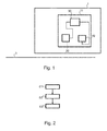
- FIG. 1 a schematic representation of an apparatus for creating a customized safety map for a motor vehicle 1 according to an embodiment of the invention.
- a device 10 for creating a customized safety map for a motor vehicle 1 includes, for example, a sensor device 20, an evaluation device 30, and a generation device 40.
- the sensor device 20 can be designed as a camera device and can be designed to capture video images.
- the sensor device 20 may be designed as a laser sensor device and may be designed to detect a reflectivity of the road at at least one characteristic wavelength.
- optical camera sensors and laser sensors can also be combined in the sensor device 20.
- the characteristic wavelength can be a spectral line or resonance line for which water, snow or ice show absorption.
- the evaluation device 30 may be designed to determine a present road condition of a roadway 3 based on the captured video images.
- the generation device 40 may be designed to create the adapted safety map on the basis of the determined present road condition of the roadway 3 and a primary safety map.
- the primary safety map may be designed as a road map, which contains primarily terrain information or other topographical data on the course of the roadway 3 or general data on the roadway condition of the roadway 3.
- FIG. 2 shows a flowchart of a method for creating a customized safety map for a motor vehicle according to a further embodiment of the invention.
- the procedure for creating a customized safety map for a motor vehicle includes the following steps:
- S1 road condition data such as in the form of video images or in the form of reflectivity values by means of a sensor device.
- a creation S3 of the adapted safety map takes place on the basis of the determined present road condition and a primary safety map.
- the method steps can be repeated iteratively or recursively and in any order.
Landscapes
- Engineering & Computer Science (AREA)
- Remote Sensing (AREA)
- Radar, Positioning & Navigation (AREA)
- Physics & Mathematics (AREA)
- General Physics & Mathematics (AREA)
- Automation & Control Theory (AREA)
- Theoretical Computer Science (AREA)
- Life Sciences & Earth Sciences (AREA)
- Atmospheric Sciences (AREA)
- Mathematical Physics (AREA)
- Business, Economics & Management (AREA)
- Educational Administration (AREA)
- Educational Technology (AREA)
- Ecology (AREA)
- General Engineering & Computer Science (AREA)
- Computer Hardware Design (AREA)
- Multimedia (AREA)
- Traffic Control Systems (AREA)
- Navigation (AREA)
Applications Claiming Priority (1)
| Application Number | Priority Date | Filing Date | Title |
|---|---|---|---|
| DE102013226631.6A DE102013226631A1 (de) | 2013-12-19 | 2013-12-19 | Verfahren und Vorrichtung zur Ermittlung von lokalen Wetterverhältnissen und eines lokalen Fahrbahnzustands |
Publications (1)
| Publication Number | Publication Date |
|---|---|
| EP2889583A1 true EP2889583A1 (fr) | 2015-07-01 |
Family
ID=50639277
Family Applications (1)
| Application Number | Title | Priority Date | Filing Date |
|---|---|---|---|
| EP14166351.8A Pending EP2889583A1 (fr) | 2013-12-19 | 2014-04-29 | Procédé et dispositif de fabrication d'une carte de sécurité adaptée pour un véhicule automobile |
Country Status (2)
| Country | Link |
|---|---|
| EP (1) | EP2889583A1 (fr) |
| DE (1) | DE102013226631A1 (fr) |
Cited By (5)
| Publication number | Priority date | Publication date | Assignee | Title |
|---|---|---|---|---|
| EP3037314A1 (fr) * | 2014-12-22 | 2016-06-29 | HERE Global B.V. | Procédé et appareil permettant de fournir des données de frottement de la surface de la route pour une action de réponse |
| WO2018188923A1 (fr) * | 2017-04-10 | 2018-10-18 | Robert Bosch Gmbh | Procédé et dispositif servant à créer et à fournir une carte |
| DE102019213471A1 (de) * | 2019-09-05 | 2021-03-11 | Robert Bosch Gmbh | Verfahren zum Schätzen eines Reibungskoeffizienten µ für ein Kraftfahrzeug |
| CN112997189A (zh) * | 2018-10-31 | 2021-06-18 | 罗伯特·博世有限公司 | 借助第一超声波传感器的道路潮湿信息来支持行进工具的基于摄像机的周围环境识别的方法 |
| EP4215877A1 (fr) * | 2022-01-21 | 2023-07-26 | Klimator AB | Procédé et système pour déterminer une prévision optimisée relative à la météo ou à l'état de la route |
Families Citing this family (22)
| Publication number | Priority date | Publication date | Assignee | Title |
|---|---|---|---|---|
| DE102015016975A1 (de) * | 2015-12-24 | 2017-06-29 | Audi Ag | Verfahren zum Anpassen einer Reichweitenprädiktion eines Kraftfahrzeugs anhand von Umgebungsbedingungen und Kraftfahrzeug |
| DE102016002768C5 (de) | 2016-03-05 | 2024-05-02 | Audi Ag | Verfahren zum Betreiben eines mehrere Kraftfahrzeuge umfassenden Kommunikationsnetzes und Kraftfahrzeug |
| DE102016205430A1 (de) * | 2016-04-01 | 2017-10-05 | Robert Bosch Gmbh | Verfahren und Vorrichtung zur Reibwertbestimmung eines befahrbaren Untergrunds mittels eines Ego-Fahrzeugs |
| DE102017213695B4 (de) * | 2017-08-07 | 2024-05-16 | Bayerische Motoren Werke Aktiengesellschaft | Verfahren, Vorrichtung, mobiles Anwendergerät, Computerprogramm zum maschinellen Lernen für ein Sensorsystem eines Fahrzeugs |
| DE102017213694B4 (de) * | 2017-08-07 | 2024-05-16 | Bayerische Motoren Werke Aktiengesellschaft | Verfahren, Vorrichtung, mobiles Anwendergerät, Computerprogramm zum maschinellen Lernen für ein Sensorsystem eines Fahrzeugs |
| DE102017213693A1 (de) * | 2017-08-07 | 2019-02-07 | Bayerische Motoren Werke Aktiengesellschaft | Verfahren, Vorrichtung, mobiles Anwendergerät, Computerprogramm zum maschinellen Lernen für ein Sensorsystem eines Fahrzeugs |
| DE102017213692A1 (de) * | 2017-08-07 | 2019-02-07 | Bayerische Motoren Werke Aktiengesellschaft | Verfahren, Vorrichtung, mobiles Anwendergerät, Computerprogramm zum maschinellen Lernen für ein Sensorsystem eines Fahrzeugs |
| DE102017214070A1 (de) * | 2017-08-11 | 2019-02-14 | Robert Bosch Gmbh | Verfahren und Vorrichtung zum Ermitteln eines Reibwertes einer Fahrbahn |
| DE102017214094A1 (de) * | 2017-08-11 | 2019-02-14 | Robert Bosch Gmbh | Verfahren und Vorrichtung zum Ermitteln eines Reibwertes einer Fahrbahn |
| DE102017214086A1 (de) * | 2017-08-11 | 2019-02-14 | Robert Bosch Gmbh | Verfahren und Vorrichtung zum Ermitteln eines Reibwertes einer Fahrbahn |
| DE102017214090A1 (de) * | 2017-08-11 | 2019-02-14 | Robert Bosch Gmbh | Verfahren und Vorrichtung zum Ermitteln eines Reibwertes einer Fahrbahn |
| JP6592051B2 (ja) * | 2017-09-25 | 2019-10-16 | 本田技研工業株式会社 | 車両制御装置 |
| DE102017009091B4 (de) * | 2017-09-28 | 2022-11-03 | Audi Ag | Verfahren zum Ermitteln einer Fahrempfehlung, Fahrassistenzsystem für ein Kraftfahrzeug und Kraftfahrzeug mit einem Fahrassistenzsystem |
| DE102018206741A1 (de) * | 2018-05-02 | 2019-11-07 | Robert Bosch Gmbh | Ultraschallsystem eines Fahrzeugs |
| DE102018214894A1 (de) * | 2018-09-03 | 2020-03-05 | Robert Bosch Gmbh | Verfahren und Vorrichtung zum Betreiben eines automatisierten Fahrzeugs |
| DE102019202773A1 (de) * | 2019-03-01 | 2020-09-03 | Zf Friedrichshafen Ag | Verfahren zum Erkennen von Nässe auf einer Fahrbahn |
| DE102019214217A1 (de) * | 2019-09-18 | 2021-03-18 | Zf Friedrichshafen Ag | Computerimplementiertes Verfahren zum maschinellen Lernen eines Wetters, Steuergerät für automatisierte Fahrfunktionen, Überwachungssystem für ein Fahrzeug und Verfahren und Computerprogrammprodukt zum Bestimmen eines Wetters |
| DE102019130037B4 (de) * | 2019-11-07 | 2022-09-29 | Mercedes-Benz Group AG | Verfahren zum Betrieb mindestens eines Umfelderfassungssensors eines Fahrzeugs |
| DE102020210269A1 (de) | 2020-08-13 | 2022-02-17 | Robert Bosch Gesellschaft mit beschränkter Haftung | Verfahren zum Ermitteln von Fahrbahnbedingungen |
| DE102021110184A1 (de) | 2021-04-22 | 2022-10-27 | Dr. Ing. H.C. F. Porsche Aktiengesellschaft | Computerimplementiertes Verfahren zur Abschätzung von Fahrbahneigenschaften |
| DE102021211006A1 (de) | 2021-09-30 | 2023-03-30 | Robert Bosch Gesellschaft mit beschränkter Haftung | Kameravorrichtung, System und Verfahren zur Wetterdatenbestimmung |
| DE102022128734A1 (de) | 2022-10-28 | 2024-05-08 | Bayerische Motoren Werke Aktiengesellschaft | Verfahren zur Vorkonditionierung einer temperierbaren Sensorabdeckung, Recheneinrichtung für ein Fahrzeug, computerlesbares Speichermedium, temperierbares Sensorabdeckungssystem sowie Fahrzeug |
Citations (7)
| Publication number | Priority date | Publication date | Assignee | Title |
|---|---|---|---|---|
| DE19824625A1 (de) * | 1997-09-30 | 1999-04-01 | Univ Ilmenau Tech | Vorrichtung zur Detektion des Zustandes von Oberflächen |
| DE10139668A1 (de) * | 2001-08-11 | 2003-02-20 | Bayerische Motoren Werke Ag | Verfahren zum Erzeugen von fahrtroutenbezogenen Wetterinformationen |
| EP1321742A2 (fr) * | 2001-12-18 | 2003-06-25 | ZF Lemförder Metallwaren AG | Méthode et dispositif de généreration et mise à jour d'une carte routière et/ou d'une carte des conditions routières |
| WO2009027122A1 (fr) * | 2007-08-25 | 2009-03-05 | Continental Teves Ag & Co. Ohg | Unité de mise à jour et procédé de mise à jour d'une carte numérique |
| DE112010005669T5 (de) * | 2010-06-18 | 2013-05-16 | Honda Motor Co., Ltd. | System zur Straßenoberflächenreflektivitätsklassifizierung |
| DE102012004998A1 (de) * | 2012-03-13 | 2013-07-11 | Daimler Ag | Verfahren zur Bereitstellung von lokalen Wetterdaten durch Kraftfahrzeuge |
| DE102012102693A1 (de) * | 2012-03-29 | 2013-10-02 | Continental Automotive Gmbh | Verfahren und Vorrichtung zur Bereitstellung von Verkehrsinformationen in Fahrzeugen |
Family Cites Families (5)
| Publication number | Priority date | Publication date | Assignee | Title |
|---|---|---|---|---|
| DE3637165A1 (de) * | 1986-10-31 | 1988-05-05 | Rainer Ashauer | Verfahren und einrichtung zum verhindern von zusammenstoessen, insbesondere fuer kraftfahrzeuge im strassenverkehr |
| DE4204165C1 (en) * | 1992-02-13 | 1993-06-03 | Deutsche Aerospace Ag, 8000 Muenchen, De | Opto-electronic snow fall detection method for guided missile - evaluating noise component in reflected laser light beam signal caused by reflection from individual snowflakes |
| US6807473B1 (en) | 2003-04-09 | 2004-10-19 | Continental Teves, Inc. | Road recognition system |
| DE10326358B9 (de) * | 2003-06-04 | 2013-05-29 | Volkswagen Ag | Vorrichtung zur Fahrerwarnung und zur Anhaltewegverkürzung |
| DE102010034029A1 (de) * | 2010-08-11 | 2012-02-16 | Conti Temic Microelectronic Gmbh | Sensor mit einem Gehäuse zur Montage an eine Scheibe |
-
2013
- 2013-12-19 DE DE102013226631.6A patent/DE102013226631A1/de active Pending
-
2014
- 2014-04-29 EP EP14166351.8A patent/EP2889583A1/fr active Pending
Patent Citations (7)
| Publication number | Priority date | Publication date | Assignee | Title |
|---|---|---|---|---|
| DE19824625A1 (de) * | 1997-09-30 | 1999-04-01 | Univ Ilmenau Tech | Vorrichtung zur Detektion des Zustandes von Oberflächen |
| DE10139668A1 (de) * | 2001-08-11 | 2003-02-20 | Bayerische Motoren Werke Ag | Verfahren zum Erzeugen von fahrtroutenbezogenen Wetterinformationen |
| EP1321742A2 (fr) * | 2001-12-18 | 2003-06-25 | ZF Lemförder Metallwaren AG | Méthode et dispositif de généreration et mise à jour d'une carte routière et/ou d'une carte des conditions routières |
| WO2009027122A1 (fr) * | 2007-08-25 | 2009-03-05 | Continental Teves Ag & Co. Ohg | Unité de mise à jour et procédé de mise à jour d'une carte numérique |
| DE112010005669T5 (de) * | 2010-06-18 | 2013-05-16 | Honda Motor Co., Ltd. | System zur Straßenoberflächenreflektivitätsklassifizierung |
| DE102012004998A1 (de) * | 2012-03-13 | 2013-07-11 | Daimler Ag | Verfahren zur Bereitstellung von lokalen Wetterdaten durch Kraftfahrzeuge |
| DE102012102693A1 (de) * | 2012-03-29 | 2013-10-02 | Continental Automotive Gmbh | Verfahren und Vorrichtung zur Bereitstellung von Verkehrsinformationen in Fahrzeugen |
Cited By (6)
| Publication number | Priority date | Publication date | Assignee | Title |
|---|---|---|---|---|
| EP3037314A1 (fr) * | 2014-12-22 | 2016-06-29 | HERE Global B.V. | Procédé et appareil permettant de fournir des données de frottement de la surface de la route pour une action de réponse |
| US9815476B2 (en) | 2014-12-22 | 2017-11-14 | Here Global B.V. | Method and apparatus for providing road surface friction data for a response action |
| WO2018188923A1 (fr) * | 2017-04-10 | 2018-10-18 | Robert Bosch Gmbh | Procédé et dispositif servant à créer et à fournir une carte |
| CN112997189A (zh) * | 2018-10-31 | 2021-06-18 | 罗伯特·博世有限公司 | 借助第一超声波传感器的道路潮湿信息来支持行进工具的基于摄像机的周围环境识别的方法 |
| DE102019213471A1 (de) * | 2019-09-05 | 2021-03-11 | Robert Bosch Gmbh | Verfahren zum Schätzen eines Reibungskoeffizienten µ für ein Kraftfahrzeug |
| EP4215877A1 (fr) * | 2022-01-21 | 2023-07-26 | Klimator AB | Procédé et système pour déterminer une prévision optimisée relative à la météo ou à l'état de la route |
Also Published As
| Publication number | Publication date |
|---|---|
| DE102013226631A1 (de) | 2015-06-25 |
Similar Documents
| Publication | Publication Date | Title |
|---|---|---|
| EP2889583A1 (fr) | Procédé et dispositif de fabrication d'une carte de sécurité adaptée pour un véhicule automobile | |
| DE102015207804B4 (de) | Verfahren zum Erkennen von Parkflächen und/oder Freiflächen | |
| DE102005044486B4 (de) | Verfahren zur Detektion des Oberflächenzustands einer Fahrbahn, sowie Detektionssystem und Fahrerassistenzsystem zur Umsetzung des Verfahrens | |
| WO2014094766A1 (fr) | Procédé pour déterminer un état de la chaussée à partir de données de capteurs de l'environnement | |
| DE102013223367A1 (de) | Verfahren und Vorrichtung zur Bestimmung eines Fahrbahnzustands mittels eines Fahrzeugkamerasystems | |
| DE102004018088A1 (de) | Fahrbahnerkennungssystem | |
| EP2795537A1 (fr) | Détermination d'un profil de hauteur d'un environnement de véhicule au moyen d'un appareil de prise de vues 3d | |
| DE102011081614A1 (de) | Verfahren und Vorrichtung zur Analysierung eines von einem Fahrzeug zu befahrenden Streckenabschnitts | |
| DE102007030731A1 (de) | System und Verfahren zur Stützung einer Längsführung eines Fahrzeugs | |
| DE102017117579A1 (de) | Verfahren und systeme zum automatischen erfassen von gefährlichen strassenbedingungen und reagieren darauf | |
| DE102011105074A1 (de) | Verfahren und Vorrichtung zur Bestimmung einer Sichtweite für ein Fahrzeug | |
| WO2021037710A1 (fr) | Procédé et dispositif pour déterminer en temps réel des propriétés d'une voie de circulation empruntée par un véhicule dans l'instant | |
| DE102018132355A1 (de) | Verfahren zur Verkehrszeichenbestimmung | |
| DE19833614A1 (de) | Verfahren zur Verkehrsqualitätserkennung und Fahrzeug als Mittel dazu | |
| DE102016221591A1 (de) | Verfahren und Vorrichtung zur Bewertung eines Fahrbahnzustands und Fahrerassistenzsystem | |
| DE102019007642A1 (de) | Verfahren zur Prädiktion von Seitenwind | |
| WO2019063208A1 (fr) | Procédé d'identification automatisée des surfaces de stationnement et/ou des surfaces de non stationnement | |
| DE10322303A1 (de) | Verfahren und Vorrichtung zur Verkehrssituationsermittlung | |
| DE102019107279A1 (de) | Verfahren und Vorrichtung zum Erkennen eines Verkehrsrechtsverstoßes durch Unterschreiten eines zulässigen Abstands zwischen einem Folgefahrzeug und einem Führungsfahrzeug | |
| DE102011122825B4 (de) | Vorrichtung zur Erfassung von Umfeldinformationen eines Kraftfahrzeuges | |
| DE102019118106B4 (de) | Verfahren zur Ermittlung einer Sichtweite | |
| DE102014223259A1 (de) | Verfahren zum Schätzen des Fahrstreifenverlaufs einer Fahrbahn | |
| DE102014011851B4 (de) | Konzept zur Erkennung einer Falschfahrt | |
| DE102011009464A1 (de) | Vorrichtung zur Erfassung von Umfeldinformationen eines Kraftfahrzeuges | |
| DE102019008079A1 (de) | Verfahren zum Erkennen mindestens eines Objekts in einem Fahrbereich eines Fahrzeugs, Vorrichtung eingerichtet zum Druchführen eines solchen Verfahrens, und Fahrzeug mit einer solchen Vorrichtung |
Legal Events
| Date | Code | Title | Description |
|---|---|---|---|
| PUAI | Public reference made under article 153(3) epc to a published international application that has entered the european phase |
Free format text: ORIGINAL CODE: 0009012 |
|
| 17P | Request for examination filed |
Effective date: 20140429 |
|
| AK | Designated contracting states |
Kind code of ref document: A1 Designated state(s): AL AT BE BG CH CY CZ DE DK EE ES FI FR GB GR HR HU IE IS IT LI LT LU LV MC MK MT NL NO PL PT RO RS SE SI SK SM TR |
|
| AX | Request for extension of the european patent |
Extension state: BA ME |
|
| R17P | Request for examination filed (corrected) |
Effective date: 20160104 |
|
| RBV | Designated contracting states (corrected) |
Designated state(s): AL AT BE BG CH CY CZ DE DK EE ES FI FR GB GR HR HU IE IS IT LI LT LU LV MC MK MT NL NO PL PT RO RS SE SI SK SM TR |
|
| RAP1 | Party data changed (applicant data changed or rights of an application transferred) |
Owner name: CONTINENTAL TEVES AG & CO. OHG Owner name: CONTI TEMIC MICROELECTRONIC GMBH |
|
| STAA | Information on the status of an ep patent application or granted ep patent |
Free format text: STATUS: EXAMINATION IS IN PROGRESS |
|
| 17Q | First examination report despatched |
Effective date: 20201112 |
|
| RAP1 | Party data changed (applicant data changed or rights of an application transferred) |
Owner name: CONTINENTAL TEVES AG & CO. OHG Owner name: CONTI TEMIC MICROELECTRONIC GMBH |
|
| STAA | Information on the status of an ep patent application or granted ep patent |
Free format text: STATUS: EXAMINATION IS IN PROGRESS |
|
| APBK | Appeal reference recorded |
Free format text: ORIGINAL CODE: EPIDOSNREFNE |
|
| APBN | Date of receipt of notice of appeal recorded |
Free format text: ORIGINAL CODE: EPIDOSNNOA2E |
|
| APBR | Date of receipt of statement of grounds of appeal recorded |
Free format text: ORIGINAL CODE: EPIDOSNNOA3E |
|
| RAP1 | Party data changed (applicant data changed or rights of an application transferred) |
Owner name: CONTINENTAL AUTONOMOUS MOBILITY GERMANY GMBH |
|
| APAF | Appeal reference modified |
Free format text: ORIGINAL CODE: EPIDOSCREFNE |