EP2042891A2 - Wetterinformationsanzeigevorrichtung - Google Patents
Wetterinformationsanzeigevorrichtung Download PDFInfo
- Publication number
- EP2042891A2 EP2042891A2 EP08015271A EP08015271A EP2042891A2 EP 2042891 A2 EP2042891 A2 EP 2042891A2 EP 08015271 A EP08015271 A EP 08015271A EP 08015271 A EP08015271 A EP 08015271A EP 2042891 A2 EP2042891 A2 EP 2042891A2
- Authority
- EP
- European Patent Office
- Prior art keywords
- display
- weather information
- unit
- icons
- map
- Prior art date
- Legal status (The legal status is an assumption and is not a legal conclusion. Google has not performed a legal analysis and makes no representation as to the accuracy of the status listed.)
- Granted
Links
- 230000008859 change Effects 0.000 claims description 12
- 230000004044 response Effects 0.000 claims description 7
- 238000001514 detection method Methods 0.000 claims description 4
- 238000000034 method Methods 0.000 description 5
- 238000013500 data storage Methods 0.000 description 3
- 230000005540 biological transmission Effects 0.000 description 2
- 239000000654 additive Substances 0.000 description 1
- 230000000996 additive effect Effects 0.000 description 1
- 238000004364 calculation method Methods 0.000 description 1
- 230000001413 cellular effect Effects 0.000 description 1
- 230000000295 complement effect Effects 0.000 description 1
- 239000000470 constituent Substances 0.000 description 1
- 238000010586 diagram Methods 0.000 description 1
- 230000005674 electromagnetic induction Effects 0.000 description 1
- 239000000284 extract Substances 0.000 description 1
- 238000000605 extraction Methods 0.000 description 1
- 230000006870 function Effects 0.000 description 1
- 239000004973 liquid crystal related substance Substances 0.000 description 1
- 230000003287 optical effect Effects 0.000 description 1
- 230000008520 organization Effects 0.000 description 1
- 230000002093 peripheral effect Effects 0.000 description 1
- 238000005096 rolling process Methods 0.000 description 1
Images


Classifications
-
- G—PHYSICS
- G01—MEASURING; TESTING
- G01W—METEOROLOGY
- G01W1/00—Meteorology
-
- G—PHYSICS
- G01—MEASURING; TESTING
- G01C—MEASURING DISTANCES, LEVELS OR BEARINGS; SURVEYING; NAVIGATION; GYROSCOPIC INSTRUMENTS; PHOTOGRAMMETRY OR VIDEOGRAMMETRY
- G01C21/00—Navigation; Navigational instruments not provided for in groups G01C1/00 - G01C19/00
- G01C21/26—Navigation; Navigational instruments not provided for in groups G01C1/00 - G01C19/00 specially adapted for navigation in a road network
- G01C21/34—Route searching; Route guidance
- G01C21/36—Input/output arrangements for on-board computers
- G01C21/3691—Retrieval, searching and output of information related to real-time traffic, weather, or environmental conditions
- G01C21/3694—Output thereof on a road map
Definitions
- the present invention relates to a weather information display device for displaying weather information while superposing the weather information on a map.
- Some conventional navigation devices e.g., JP 2000-193469A
- the weather information of the present position and/or the travel route are displayed by superposing or overlapping on a displayed map. Further, icons indicating the weather information are also displayed on the weather information.
- the area for displaying the weather information must be changed correspondingly.
- the icons cannot be changed in size in proportion to the scale size, because the icons must be easily viewed and recognized. It is proposed therefore to fix the size of icons.
- the icons may overlap on the map when the scale size of the map is changed to cover wider area.
- a weather information display device comprises a map information acquiring unit, a weather information acquiring unit, a display unit, and a display control unit.
- the map information acquiring unit acquires map information.
- the weather information acquiring unit acquires weather information which is set in connection with a predetermined unit of section on a map.
- the display unit displays various information for a user.
- the display control unit displays a map on the display unit on the basis of the map information acquired by the map information acquiring unit, and controls a display mode of sections displayed on the map so that a section corresponding to the weather information acquired by the weather information acquiring unit on the displayed map is distinguishable from other sections.
- the display control unit further performs icon display control processing, which includes causing the display unit to display icons indicating weather information on corresponding sections on the map, checking whether the icons displayed on the map overlap, causing the display unit to display only one icon by combining overlapping icons if the overlapping icons are of a same type, and causing the display unit to display the overlapping icons so that an icon of weather information of higher display priority is laid over an icon of weather information of lower display priority if the overlapping icons are of different types.
- the weather information is assigned with different display priorities.
- a navigation device 20 which operates also as a weather information display device, is shown with an information center 5.
- the navigation device 20 is mounted in a vehicle, and equipped with a position detector 21 for detecting the position, speed, travel direction, etc. of the vehicle, an operation switch group 22 for inputting various kinds of instructions from a user, a remote controller 23a which can input various kinds of instructions like the operation switch group 22, a remote controller sensor 23b to which a signal from the remote controller 23a is input, an external communication device 24 for communicating with the external information center 5, a map data input unit 25 for inputting map data, etc.
- a display device 26 for performing various kinds of displays such as map display, etc.
- a voice output device 27 for outputting various kinds of guide voices, etc.
- a control unit 29, and an external memory 28 which is connected to the control unit 29 and stores various kinds of information.
- the position detector 21 includes a GPS receiver 21a for receiving transmission electric waves from artificial satellites for global positioning system (GPS) through a GPS antenna to detect the position, speed, travel direction, etc. of the vehicle, a gyroscope 21b for detecting the magnitude of a rotational motion applied to the vehicle, and a distance sensor 21c for detecting the travel distance of the vehicle.
- GPS global positioning system
- These sensors, etc. 21a to 21c have errors having different properties, and thus they are constructed and used so as to mutually complement one another.
- the position detector 21 may include only some of these sensors, or the position detector 21 may further include in addition a rotational sensor for a steering, a wheel sensor for each rolling wheel, etc.
- a touch panel which is constructed integrally with the display device 26 and mounted on the display screen, mechanical key switches provided around the display device 26, etc. are used as the operation switch group 22.
- the touch panel and the display device 26 are integrally stacked, and various types such as a pressure sensitive type, an electromagnetic induction type, an electrostatic capacity type or a combination type thereof are used for the touch panel.
- the touch panel as the switch group 22 corresponds to an instruction detection unit.
- the external communication device 24 performs information communication with the external information center 5 to receive weather information which is distributed from the information center 5 with FM multiple broadcasting, electric waves/optical beacon or the like.
- the external communication device 24 may be designed so as to receive weather information through a telephone line network such as the Internet or the like from the information center 5.
- the external communication device 24 corresponds to a weather information acquiring unit.
- the map data input unit 25 is a device for inputting various kinds of data stored in a map data storage medium (for example, a hard disc, DVD-ROM or the like). Map data (node data, link data, cost data, background data, road data, name data, mark data, cross-point data, facilities data, etc.), voice data for guide, voice recognition data, etc. are stored in the map data storage medium. In place of input of these data from the map data storage medium, these data may be input through a communication network from an external site.
- the map data input unit 25 corresponds to a map information acquiring unit.
- the display device 26 is a color display device, and any one of a liquid crystal display, a plasma display, CRT, etc. may be used. On the display screen of the display device 26 may be displayed a mark representing the present place which is specified from the present position of the vehicle detected by the position detector 21 and map data input from the map data input unit 25, a guide route to a destination and additive data such as names, markers, symbol marks of various kinds of facilities, etc. while these data are superposed on one another. Furthermore, in order to display sections corresponding to weather information set in connection with a predetermined section unit on a map so that the sections concerned are discriminable from other sections, the sections concerned may be displayed while the display mode of the sections concerned on the map is changed ( Fig. 4B ). The display device 26 corresponds to a display unit.
- the voice output device 27 may output voices for various kinds of guides such as a travel guide, etc.
- the control unit 29 is mainly constructed with a well-known microcomputer including CPU, ROM, RAM, I/O, a bus line connecting these constituent elements to one another, etc.
- the control unit 29 executes various kinds of processing in accordance with inputs from the position detector 21, the operation switch group 22, the remote control sensor 23b, the external communication device 24 and the map data input unit 25 and controls the external communication device 24, the display device 26 and the voice output device 27.
- the control unit 29 executes various kinds of processing according to programs stored in ROM, etc. by using data in the external memory 28 as occasion demands.
- map display processing is the processing of calculating the present position of the vehicle as a pair of the coordinate and the travel direction on the basis of each detection signal from the position detector 21, and displaying on the display device 26 a map in the neighborhood of the present position of the vehicle, etc. which are read out through the map data input unit 25.
- the route guide processing is the processing of calculating the optimum road from the present position to a destination on the basis of map data stored in the map data input unit 25 and the destination which is set according to the operation of the operation switch 22, the remote controller 23 or the like, and performing a travel guide concerning the calculated route.
- a method of cost calculation based on Dijkstra method or the like is known as the method of automatically setting the optimum route as described above.
- the control unit 29 also executes display processing of weather information in addition to or in parallel manner to the map display processing, the route guide processing, etc. described above. The details of this processing will be described in detail later.
- the control unit 29 corresponds to a display control unit.
- the navigation device 20 acquires weather information from the information center 5 through the external communication device 24.
- the information center 5 is connected through a communication line to a wireless base station which can communicate with each vehicle.
- the information center 5 wirelessly communicates with the navigation device 20 through the wireless base station, and transmits weather information to the navigation device 20.
- the information center 5 has a weather information database for storing weather information to be transmitted to the navigation device 20, a line terminal device for performing communications through the communication line (both are not shown), a server for managing data (not shown), etc.
- the weather information database stores weather information of a relatively broad area accumulated on the basis of information which is collected from an organization for supplying observation information of weather or the like as needed.
- This weather information is accumulated in association with a predetermined section unit on the map.
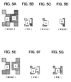
- This predetermined section may be a section based on a grid section on the basis of the latitude and longitude, or a section divided by administrative boundaries. In this embodiment, as shown in Fig. 4B , the grid-based section divided by the latitude and longitude is used.
- the predetermined section is represented by "section” or "grid” appropriately.
- the weather information accumulated in the weather information database contains weather alarm (tornado, flood, etc.), present state information/forecast information (fair, rain, thunder, storm, etc.), road information (freeze, overhead flooding, etc.). Tornado, thunder showers, typhoon, rain, fog, sleet, snow, hail, etc. are contained.
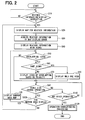
- a map for displaying weather information is displayed.
- this map may have a predetermined range containing the position of the subject vehicle at the center thereof or a map having a predetermined range indicated by the user.
- the weather information display map is a specialized map for displaying only weather information, and thus guide route, peripheral facilities information, landmarks, etc. in a route guide are not displayed on this map.
- weather information corresponding to the map display range displayed in S20 is acquired.
- Various methods may be considered to acquire the weather information. Here, the following three methods will be described.
- the information center 5 extracts the weather information corresponding to the map display range transmitted from the navigation device 20 from the present-time weather information accumulated in the weather information database, and then transmits the extracted weather information to the navigation device 20.
- the processing proceeds to S40.
- the acquired weather information is displayed together with icons.
- Fig. 4A shows a table indicating the corresponding relation of the type of weather information, display priority and display mode. This relation is stored in the external memory 28, for example.
- the weather information types A, B, C, ... are set in connection with display priorities 1, 2, 3, ..., and further display modes a, b, c, ... are also set.
- This display mode represents a color or a texture pattern, for example.
- the difference in weather information can be discriminated by the difference in the color or the texture pattern.
- this corresponding-relation table is referred to, so that the corresponding sections of the weather information are displayed in the displayed modes corresponding to the weather information, respectively.
- the icons indicating the weather information are displayed on the sections corresponding to the weather information.
- the icons may be formed by letters or marks indicating the weather information. For instance, a tornado may be indicated by letters as "TORNADO" or by a mark of tornado.
- Each icon may be displayed on the displayed map according to a predetermined rule. For instance, the icon may be positioned in the center of the section or sections of the corresponding weather information as shown in Fig. 4B . In this example, one icon A is displayed in the center of one group of sections of one weather information, and another icon B is displayed in the center of another group of sections of another weather information.
- the icons A and B do not overlap in a case of default displays shown in Figs. 5A and 5E . However, the icons A and/or B overlap in a case where the scale size of the map is changed to wide area display (reduced size display) while maintaining the icon size unchanged as shown in Figs. 5B and 5F .
- the icons overlap (S50: YES), it is then checked whether the overlapping icons are the same type (S60). If the icons are not the same type (NO: S60), the icons are displayed by overlapping in a predetermined order of display priorities (S70). In this S70, the corresponding-relation table is referred to and the display priorities of weather information of sections (icon-overlapping sections) are compared. The icon of higher display priority is laid over the icon of lower display priority on the map, so that the icon of highest display priority among the icon-overlapping sections may be fully displayed most foreside on the display screen as if it is stacked on other icons of lower priorities. If the icons of the weather information A and B overlap, the icon A is laid over the icon B as shown in Fig. 5B , because the weather information A has higher display priority over the weather information B.
- overlapping icons are the same type (S60: YES) as shown in Fig. 5F , only one icon is displayed by combining the icons into one as shown in Fig. 5G .
- S90 is executed. If the check result in S50 is NO indicating no overlapping of icons, S90 is executed.
- S90 it is checked whether a scale size of map display is changed by a switch in the switch group 22. If scale size change operation is made (S90: YES), it is further checked whether the change is for map display of narrower area, that is, for displaying the map in more detail or in a more enlarged manner (S100). If it is a change to a narrow area map display or an enlarged map display (S100: YES) like Figs. 5A and 5E , the map display on the display device 26 is changed to narrow area map display (S105), so that the processing returns to S50. If the change is not for the narrow area display (detailed area display), that is, the change is for wide area map display like Figs. 5B and 5F (S100: NO), the processing returns to S20.
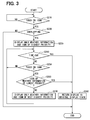
- This processing in S120 includes display switching of weather information and icons, which is shown in detail in Fig. 3 .
- S220 it is checked whether the touched icon is one of a plurality of icons overlapping with at least one other icon. If it is not overlapping (S220: NO), the display switching processing is terminated without executing S230 and its subsequent steps. If the touched icon is overlapping with at least one other icon (S220: YES), only the weather information and its corresponding icon, which has the highest display priority among the overlapping icons. For instance, if two icons A and B of different display priorities are displayed as overlapping as shown in Fig. 5B , only the icon A which is higher in display priority than the other icon B is displayed as shown in Fig. 5C by eliminating the icon B and its corresponding weather information area.
- time-out it is checked in S240 whether a predetermined time (e.g., 5 seconds) has elapsed (time-out). If it is not time-out (S240: NO), it is checked in S250 whether the icon is touched. If the icon is not touched (S250: NO), the processing returns to S240. If the predetermined time elapses without touching on the icon, it results in the time-out (S240: YES) and the processing proceeds to S280. In S280, the display ( Fig. 5C ) is automatically returned to the original display state ( Fig. 5B ), thus terminating the display switching processing.
- a predetermined time e.g., 5 seconds
- the displayed icon is touched within the predetermined time (S250: YES)
- the display may be switched over to the icon B and its corresponding weather information area as shown in Fig. 5D in S240 to S270 if the icon A is touched within the predetermined time.
- the touched icon is the icon of the lowest display priority (S260: YES), which occurs when the icon B is touched under the display state of Fig. 5D , the display is returned to the original display state shown in Fig. 5B , in which both icons A and B and respective weather information areas are displayed in overlapping manner.
- the display state shown in Figs. 5C or 5D continues more than a predetermined time, the display state returns to the original display state shown in Fig. 5B . Therefore the user need not make any manual operation to return the display state to the original state.
- the present invention is not limited to the first embodiment, and the present invention may be implemented as other embodiments as described below.
Landscapes
- Engineering & Computer Science (AREA)
- Environmental & Geological Engineering (AREA)
- Remote Sensing (AREA)
- Radar, Positioning & Navigation (AREA)
- Environmental Sciences (AREA)
- Ecology (AREA)
- Life Sciences & Earth Sciences (AREA)
- Biodiversity & Conservation Biology (AREA)
- Atmospheric Sciences (AREA)
- Automation & Control Theory (AREA)
- Physics & Mathematics (AREA)
- General Physics & Mathematics (AREA)
- Navigation (AREA)
- Traffic Control Systems (AREA)
- Instructional Devices (AREA)
Applications Claiming Priority (1)
| Application Number | Priority Date | Filing Date | Title |
|---|---|---|---|
| JP2007247395A JP4428433B2 (ja) | 2007-09-25 | 2007-09-25 | 気象情報表示装置、プログラム |
Publications (3)
| Publication Number | Publication Date |
|---|---|
| EP2042891A2 true EP2042891A2 (de) | 2009-04-01 |
| EP2042891A3 EP2042891A3 (de) | 2011-04-20 |
| EP2042891B1 EP2042891B1 (de) | 2016-09-28 |
Family
ID=40227836
Family Applications (1)
| Application Number | Title | Priority Date | Filing Date |
|---|---|---|---|
| EP08015271.3A Ceased EP2042891B1 (de) | 2007-09-25 | 2008-08-29 | Wetterinformationsanzeigevorrichtung |
Country Status (3)
| Country | Link |
|---|---|
| US (1) | US7859429B2 (de) |
| EP (1) | EP2042891B1 (de) |
| JP (1) | JP4428433B2 (de) |
Cited By (3)
| Publication number | Priority date | Publication date | Assignee | Title |
|---|---|---|---|---|
| US10281295B2 (en) | 2013-04-17 | 2019-05-07 | Tomtom Navigation B.V. | Methods, devices and computer software for facilitating searching and display of locations relevant to a digital map |
| US10733219B2 (en) | 2013-04-17 | 2020-08-04 | Tomtom Navigation B.V. | Methods, devices and computer software for facilitating searching and display of locations relevant to a digital map |
| US11720574B2 (en) | 2013-04-17 | 2023-08-08 | Tomtom Navigation B.V. | Methods, devices and computer software for facilitating searching and display of locations relevant to a digital map |
Families Citing this family (16)
| Publication number | Priority date | Publication date | Assignee | Title |
|---|---|---|---|---|
| IL159838A0 (en) | 2004-01-13 | 2004-06-20 | Yehuda Binder | Information device |
| JP4905488B2 (ja) * | 2009-03-26 | 2012-03-28 | ブラザー工業株式会社 | コンテンツを表示するための通信装置およびプログラム |
| US20100313150A1 (en) * | 2009-06-03 | 2010-12-09 | Microsoft Corporation | Separable displays and composable surfaces |
| US20110166777A1 (en) * | 2010-01-07 | 2011-07-07 | Anand Kumar Chavakula | Navigation Application |
| US20110242136A1 (en) * | 2010-03-31 | 2011-10-06 | Denso Corporation | Map display device |
| US20110279445A1 (en) * | 2010-05-16 | 2011-11-17 | Nokia Corporation | Method and apparatus for presenting location-based content |
| US9122707B2 (en) * | 2010-05-28 | 2015-09-01 | Nokia Technologies Oy | Method and apparatus for providing a localized virtual reality environment |
| JP5899524B2 (ja) * | 2010-12-16 | 2016-04-06 | 株式会社ユピテル | 車載用電子機器 |
| US9639857B2 (en) | 2011-09-30 | 2017-05-02 | Nokia Technologies Oy | Method and apparatus for associating commenting information with one or more objects |
| US9080885B2 (en) * | 2012-06-05 | 2015-07-14 | Apple Inc. | Determining to display designations of points of interest within a map view |
| JP2014203399A (ja) * | 2013-04-09 | 2014-10-27 | 株式会社デンソー | ドライバ情報表示装置、ドライバ情報表示プログラム、ドライバ情報表示プログラムを記録した記録媒体 |
| US8874288B1 (en) * | 2013-06-20 | 2014-10-28 | Raytheon Company | Adding weather icon to electronic flight strips |
| JP6315910B2 (ja) * | 2013-07-09 | 2018-04-25 | 三菱電機株式会社 | 情報提示装置および情報提示方法 |
| JP5932953B2 (ja) * | 2014-12-08 | 2016-06-08 | キヤノン株式会社 | 情報処理装置、その制御方法、プログラム及び記憶媒体 |
| WO2021101528A1 (en) * | 2019-11-19 | 2021-05-27 | Google Llc | Voltage-variation detection under clock fluctuations |
| KR102257337B1 (ko) * | 2021-03-30 | 2021-05-28 | 주식회사 노아엘이디 | 환경정보에 기초하여 밝기 자동조절이 가능한 기상정보 표출 장치 |
Citations (1)
| Publication number | Priority date | Publication date | Assignee | Title |
|---|---|---|---|---|
| JP2000193469A (ja) | 1998-10-21 | 2000-07-14 | Sony Corp | ナビゲ―ション装置及び経路表示装置 |
Family Cites Families (13)
| Publication number | Priority date | Publication date | Assignee | Title |
|---|---|---|---|---|
| US6587787B1 (en) * | 2000-03-15 | 2003-07-01 | Alpine Electronics, Inc. | Vehicle navigation system apparatus and method providing enhanced information regarding geographic entities |
| JP4449162B2 (ja) * | 2000-05-09 | 2010-04-14 | 株式会社エクォス・リサーチ | 地図表示装置 |
| JP3696073B2 (ja) * | 2000-09-29 | 2005-09-14 | 株式会社ケンウッド | 車載用ナビゲーション装置、情報表示方法及び記録媒体 |
| JP2002131064A (ja) | 2000-10-18 | 2002-05-09 | Nissan Motor Co Ltd | 天候情報提示装置 |
| US6405129B1 (en) * | 2000-11-29 | 2002-06-11 | Alpine Electronics, Inc. | Method of displaying POI icons for navigation apparatus |
| JP2002372427A (ja) * | 2001-06-15 | 2002-12-26 | Alpine Electronics Inc | ナビゲーション装置 |
| JP2003254761A (ja) | 2002-02-28 | 2003-09-10 | Fujitsu Ten Ltd | ナビゲーション装置 |
| JP3753110B2 (ja) | 2002-08-07 | 2006-03-08 | 株式会社デンソー | カーナビゲーション装置 |
| JP4007263B2 (ja) | 2003-06-20 | 2007-11-14 | アイシン・エィ・ダブリュ株式会社 | 自動車用ナビゲーション装置 |
| JP4421930B2 (ja) * | 2004-04-20 | 2010-02-24 | 株式会社ザナヴィ・インフォマティクス | 車載情報端末 |
| JP2007051974A (ja) * | 2005-08-19 | 2007-03-01 | Toyota Motor Corp | 天候情報センタ、経路情報提供装置 |
| JP2007163550A (ja) | 2005-12-09 | 2007-06-28 | Xanavi Informatics Corp | 情報処理装置、ナビゲーション装置、および地図データ表示方法 |
| JP4774553B2 (ja) * | 2006-02-06 | 2011-09-14 | パイオニア株式会社 | 地図表示制御装置、地図表示制御方法並びに地図表示制御用プログラム及び情報記録媒体 |
-
2007
- 2007-09-25 JP JP2007247395A patent/JP4428433B2/ja not_active Expired - Fee Related
-
2008
- 2008-08-29 EP EP08015271.3A patent/EP2042891B1/de not_active Ceased
- 2008-09-09 US US12/230,965 patent/US7859429B2/en not_active Expired - Fee Related
Patent Citations (1)
| Publication number | Priority date | Publication date | Assignee | Title |
|---|---|---|---|---|
| JP2000193469A (ja) | 1998-10-21 | 2000-07-14 | Sony Corp | ナビゲ―ション装置及び経路表示装置 |
Cited By (3)
| Publication number | Priority date | Publication date | Assignee | Title |
|---|---|---|---|---|
| US10281295B2 (en) | 2013-04-17 | 2019-05-07 | Tomtom Navigation B.V. | Methods, devices and computer software for facilitating searching and display of locations relevant to a digital map |
| US10733219B2 (en) | 2013-04-17 | 2020-08-04 | Tomtom Navigation B.V. | Methods, devices and computer software for facilitating searching and display of locations relevant to a digital map |
| US11720574B2 (en) | 2013-04-17 | 2023-08-08 | Tomtom Navigation B.V. | Methods, devices and computer software for facilitating searching and display of locations relevant to a digital map |
Also Published As
| Publication number | Publication date |
|---|---|
| US7859429B2 (en) | 2010-12-28 |
| EP2042891B1 (de) | 2016-09-28 |
| EP2042891A3 (de) | 2011-04-20 |
| US20090079587A1 (en) | 2009-03-26 |
| JP2009079916A (ja) | 2009-04-16 |
| JP4428433B2 (ja) | 2010-03-10 |
Similar Documents
| Publication | Publication Date | Title |
|---|---|---|
| EP2042891B1 (de) | Wetterinformationsanzeigevorrichtung | |
| US7971153B2 (en) | Weather information display apparatus and program | |
| JP4476687B2 (ja) | 携帯ナビゲーション端末および地図表示方法ならびにプログラム | |
| US8442768B2 (en) | Navigation system, portable terminal device, and in-vehicle device | |
| US6199012B1 (en) | Map display unit | |
| US8046710B2 (en) | Weather information display device with display icon | |
| JP4186547B2 (ja) | ナビゲーション装置およびコンピュータプログラム | |
| US8914224B2 (en) | Navigation device and method | |
| EP2194518A1 (de) | Kartenanzeigeeinrichtung | |
| US20080228393A1 (en) | Navigation device and method | |
| US8583356B2 (en) | Navigation device and method | |
| JP4480528B2 (ja) | ナビゲーションシステム | |
| US20110319099A1 (en) | Navigation or mapping system and method | |
| KR20110054825A (ko) | 이동 단말기의 내비게이션 방법 및 그 장치 | |
| JP2007298301A (ja) | 地図表示装置 | |
| JP4992533B2 (ja) | 気象情報表示装置、プログラム | |
| JP5177691B2 (ja) | 携帯ナビゲーション端末およびプログラム | |
| EP2223042B1 (de) | Verbesserte navigationseinrichtung und verfahren | |
| JP2019158455A (ja) | 天気情報表示装置 | |
| JP2005010469A (ja) | 地図情報配信方法、地図表示方法、情報配信センター、および情報端末装置 | |
| JP2019090728A (ja) | サーバ、車載装置、情報提供システム、情報提供方法、情報装置 | |
| JP2006250800A (ja) | カーナビゲーション装置 | |
| HK1150657A (en) | Navigation device & method |
Legal Events
| Date | Code | Title | Description |
|---|---|---|---|
| PUAI | Public reference made under article 153(3) epc to a published international application that has entered the european phase |
Free format text: ORIGINAL CODE: 0009012 |
|
| AK | Designated contracting states |
Kind code of ref document: A2 Designated state(s): AT BE BG CH CY CZ DE DK EE ES FI FR GB GR HR HU IE IS IT LI LT LU LV MC MT NL NO PL PT RO SE SI SK TR |
|
| AX | Request for extension of the european patent |
Extension state: AL BA MK RS |
|
| PUAL | Search report despatched |
Free format text: ORIGINAL CODE: 0009013 |
|
| AK | Designated contracting states |
Kind code of ref document: A3 Designated state(s): AT BE BG CH CY CZ DE DK EE ES FI FR GB GR HR HU IE IS IT LI LT LU LV MC MT NL NO PL PT RO SE SI SK TR |
|
| AX | Request for extension of the european patent |
Extension state: AL BA MK RS |
|
| 17P | Request for examination filed |
Effective date: 20110520 |
|
| AKX | Designation fees paid |
Designated state(s): DE GB |
|
| 17Q | First examination report despatched |
Effective date: 20140319 |
|
| GRAP | Despatch of communication of intention to grant a patent |
Free format text: ORIGINAL CODE: EPIDOSNIGR1 |
|
| RIC1 | Information provided on ipc code assigned before grant |
Ipc: G01C 21/36 20060101ALN20160314BHEP Ipc: G01W 1/00 20060101AFI20160314BHEP |
|
| INTG | Intention to grant announced |
Effective date: 20160407 |
|
| RIC1 | Information provided on ipc code assigned before grant |
Ipc: G01C 21/36 20060101ALN20160330BHEP Ipc: G01W 1/00 20060101AFI20160330BHEP |
|
| GRAS | Grant fee paid |
Free format text: ORIGINAL CODE: EPIDOSNIGR3 |
|
| GRAA | (expected) grant |
Free format text: ORIGINAL CODE: 0009210 |
|
| AK | Designated contracting states |
Kind code of ref document: B1 Designated state(s): DE GB |
|
| REG | Reference to a national code |
Ref country code: GB Ref legal event code: FG4D |
|
| REG | Reference to a national code |
Ref country code: DE Ref legal event code: R096 Ref document number: 602008046467 Country of ref document: DE |
|
| REG | Reference to a national code |
Ref country code: DE Ref legal event code: R084 Ref document number: 602008046467 Country of ref document: DE |
|
| REG | Reference to a national code |
Ref country code: DE Ref legal event code: R097 Ref document number: 602008046467 Country of ref document: DE |
|
| REG | Reference to a national code |
Ref country code: GB Ref legal event code: 746 Effective date: 20170630 |
|
| PLBE | No opposition filed within time limit |
Free format text: ORIGINAL CODE: 0009261 |
|
| STAA | Information on the status of an ep patent application or granted ep patent |
Free format text: STATUS: NO OPPOSITION FILED WITHIN TIME LIMIT |
|
| 26N | No opposition filed |
Effective date: 20170629 |
|
| PGFP | Annual fee paid to national office [announced via postgrant information from national office to epo] |
Ref country code: DE Payment date: 20180823 Year of fee payment: 11 |
|
| PGFP | Annual fee paid to national office [announced via postgrant information from national office to epo] |
Ref country code: GB Payment date: 20180822 Year of fee payment: 11 |
|
| REG | Reference to a national code |
Ref country code: DE Ref legal event code: R119 Ref document number: 602008046467 Country of ref document: DE |
|
| GBPC | Gb: european patent ceased through non-payment of renewal fee |
Effective date: 20190829 |
|
| PG25 | Lapsed in a contracting state [announced via postgrant information from national office to epo] |
Ref country code: DE Free format text: LAPSE BECAUSE OF NON-PAYMENT OF DUE FEES Effective date: 20200303 |
|
| PG25 | Lapsed in a contracting state [announced via postgrant information from national office to epo] |
Ref country code: GB Free format text: LAPSE BECAUSE OF NON-PAYMENT OF DUE FEES Effective date: 20190829 |