EP2005404B1 - Verfahren und system zur messung von verkehrsinformationen in einem cdma-netzwerk - Google Patents
Verfahren und system zur messung von verkehrsinformationen in einem cdma-netzwerk Download PDFInfo
- Publication number
- EP2005404B1 EP2005404B1 EP07715736.0A EP07715736A EP2005404B1 EP 2005404 B1 EP2005404 B1 EP 2005404B1 EP 07715736 A EP07715736 A EP 07715736A EP 2005404 B1 EP2005404 B1 EP 2005404B1
- Authority
- EP
- European Patent Office
- Prior art keywords
- location information
- traffic information
- message
- node
- rnc
- Prior art date
- Legal status (The legal status is an assumption and is not a legal conclusion. Google has not performed a legal analysis and makes no representation as to the accuracy of the status listed.)
- Active
Links
Images


Classifications
-
- G—PHYSICS
- G08—SIGNALLING
- G08G—TRAFFIC CONTROL SYSTEMS
- G08G1/00—Traffic control systems for road vehicles
- G08G1/01—Detecting movement of traffic to be counted or controlled
- G08G1/0104—Measuring and analyzing of parameters relative to traffic conditions
-
- H—ELECTRICITY
- H04—ELECTRIC COMMUNICATION TECHNIQUE
- H04W—WIRELESS COMMUNICATION NETWORKS
- H04W64/00—Locating users or terminals or network equipment for network management purposes, e.g. mobility management
- H04W64/006—Locating users or terminals or network equipment for network management purposes, e.g. mobility management with additional information processing, e.g. for direction or speed determination
Definitions
- the present invention relates to method and system for measuring traffic information in a CDMA (Code Division Multiple Access) network, and more particularly to method and system for measuring traffic information of vehicles by utilizing a mobile station in a CDMA network.
- CDMA Code Division Multiple Access
- measurement devices such as CC cameras or the like have been installed around roads to measure location, speed and so on of vehicles.
- this method requires installing measurement devices to every road to be monitored, thereby consuming much installation cost and needing many persons for management, and this method is substantially unable to measure traffic information of all roads in the country.
- Korean Laid-open Patent Publication No. 2003-88097 entitled “Traffic information service system using a wireless LAN, and a method therefor”
- No. 2005-78687 entitled “Traffic information service system using a wireless LAN bridge, and a method therefor”
- NIC Network Interface Card
- Korean Laid-open Patent Publication No. 2005-100121 entitled “System and method for collecting traffic information using location tracking information of a mobile station”, discloses collecting traffic information by using base station information of each road and effective samples of CDR (Call Data Records). This technique reads CDR data files of each exchange to extract effective samples, and processes location inquiry for HLR (Home Location Register) based on the read CDR data files so as to measure a speed of a mobile station installed to a vehicle.
- CDR Call Data Records
- a method for measuring traffic information is known, which method is conducted by a traffic information analyzing device interworking with a radio operating device connected to a cellular network, and performs the steps of acquiring a location information message of a mobile station, which is provided from a cellular network and stored in the radio operating device, of analyzing location information of the mobile station by utilizing the location information message, and of calculating traffic information of the mobile station including a moving speed of each measurement region by using the analyzed location information.
- US 6,061,337 describes a synchronous CDMA system in which each terminal only measures signals from the neighbor list of base stations, as specified by the serving base station such that they satisfy a certain power requirement. These measurements will be reported by the terminals, correspondingly, so that its positions can be determined.
- WO 01/89254 A1 pertains to the determination of a location of user equipment using true round trip time measurement in WCDMA networks.
- the present invention is designed in consideration of the above problems, and therefore it is an object of the invention to provide method and system for measuring traffic information, which collects location information and analyzes traffic information by utilizing location information-related messages exchanged between a mobile station and BSS (Base Station Subsystem) in a synchronous CDMA network.
- BSS Base Station Subsystem
- Another object of the present invention is to provide method and system for measuring traffic information, which collects location information and analyzes traffic information by utilizing location information-related messages exchanged between a mobile station and RAN (Radio Access Network) in an asynchronous WCDMA (Wideband Code Division Multiple Access) network.
- RAN Radio Access Network
- WCDMA Wideband Code Division Multiple Access
- Still another object of the present invention is to provide method and system for measuring traffic information, which may prevent system overload by conducting activation control to a location information collecting function of a mobile station for a sub-cell provided in a synchronous CDMA network or an asynchronous WCDMA network.
- the invention suggests a method for measuring traffic information regarding the movement of a mobile station according to claim 1 and claim 9, respectively, and furthermore a traffic information analyzing device according to claim 6 and claim 13, respectively.
- a method for measuring traffic information acquires location information of a mobile station by utilizing pilot measurement-related messages exchanged between the mobile station and BSS (Base Station Subsystem) in a synchronous CDMA network, and analyzes traffic information based on the acquired location information.
- BSS Base Station Subsystem
- the present invention acquires location information and analyzes traffic information by utilizing messages related to pilots that participate in the handover process.
- MS Mobile Station
- PSMM Peak Strength Measurement Message
- BSS Base Station Subsystem
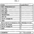
- FIG. 3 shows examples of parameters included in the PSMM.
- BSC Base Station Controller
- BSC Base Station Controller
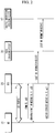
- the BSC analyzes PSMM, and then, if B sector information that is a target sector exists in a neighbor list, the BSC instructs channel allocation to a corresponding BTS (Base Transceiver Station), sends a handover direction message to the MS 10 after channel allocation, and also sends a location information message including RTD (Round Trip Delay) data periodically provided from BTS and data of the PSMM to a radio operating device 30.
- RTD Red Trip Delay
- field values of Msg ID and Seq ID are composed of a value identifying PSMM and its serial number.
- the radio operating device 30 transmits the location information message, sent from the BSS 20 and stored therein, to a traffic information analyzing device 40.
- the traffic information analyzing device 40 conducts a measurement process that analyzes location information of the MS 10 and then calculates traffic information of the MS such as a moving distance and a moving speed.
- the traffic information analyzing device 40 calculates a distance between BTSes by obtaining BTS latitude/longitude data corresponding to the location information of the MS 10, and then calculates a moving distance and a speed of each measurement region by recognizing a current location of the MS using RTD or PN_PHASE included in the location information message.
- the MS 10 adds a new pilot to an active set, and sends a handover complete message to the BSS 20, thereby completing the handover process.
- FIG. 4 mainly shows a process of acquiring location information of a mobile station by substituting PSMM of FIG. 2 with PPSMM (Periodic Pilot Strength Measurement Message).
- BSS 20 firstly sends PPMRO (Periodic Pilot Measurement Report Order) to MS 10, and the MS 10 sends PPSMM to the BSS 20 at a certain period correspondingly.
- PPMRO Period Pilot Measurement Report Order
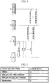
- FIGs. 5 and 6 show examples of parameters included in PPMRO and PPSMM.
- BSC of the BSS 20 periodically sends a location information message including RTD periodically provided from BTS and data of the PPSMM to the radio operating device 30.
- location information message shown in FIG. 11 field values of Msg ID and Seq ID are composed of a value identifying PPSMM and its serial number.
- the radio operating device 30 sends the location information message, sent from the BSS 20 and stored therein, to the traffic information analyzing device 40, and the traffic information analyzing device 40 conducts the measurement process as mentioned above to analyze the location information of the MS 10, thereby measuring traffic information of the MS such as a moving distance and a moving speed.
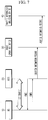
- FIG. 7 mainly shows a process of acquiring location information of a mobile station by substituting PSMM of FIG. 2 with PMRM (Pilot Measurement Report Message).
- the BSS 20 firstly sends PMRO (Pilot Measurement Report Order) to MS 10, and the MS 10 sends PMRM to the BSS 20 at a specific event correspondingly.
- PMRO Peak Measurement Report Order
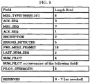
- FIG. 8 shows examples of parameters included in PMRM.
- BSC of the BSS 20 sends a location information message including RTD periodically provided from BTS and data of the PMRM to the radio operating device 30.
- field values of Msg ID and Seq ID are composed of a value identifying PMRM and its serial number.
- the radio operating device 30 sends the location information message, sent from the BSS 20 and stored therein, to the traffic information analyzing device 40.
- the traffic information analyzing device 40 conducts the measurement process as mentioned above to analyze the location information of the MS 10 and subsequently measure traffic information of the MS such as a moving distance and a moving speed.
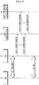
- FIG. 9 shows a process of providing a location information message according to a period set in BSC of the BSS 20 itself during calling, namely in a call-established state.
- the BSC includes only RTD provided from BTS, and sends a location information message, from which PN_PHASE of a pilot measurement-related message is excluded, to the radio operating device 30.
- the radio operating device 30 sends the location information message, sent from the BSS 20 and stored therein, to the traffic information analyzing device 40.
- the traffic information analyzing device 40 conducts the measurement process as mentioned above to analyze the location information of the MS 10 and subsequently measure traffic information of the MS such as a moving distance and a moving speed.
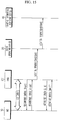
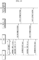
- FIG. 10 shows a traffic information measuring system according to the first embodiment of the present invention, which is provided for executing the traffic information measuring method as mentioned above.
- the traffic information measuring system includes a radio operating device 30 connected to BSS 20 of a synchronous CDMA network to acquire and store location information of MS 10, and a traffic information analyzing device 40 for receiving the location information of the MS 10 from the radio operating device 30 to measure traffic information.
- the BSS 20 includes BTS 21 for taking charge of RF sending/receiving interface for MS 10, and BSC 22 for processing setting-up of radio channels, handover and so on to manage radio resources of the BTS 21, and the BSS 20 is connected to MSC 25 (Mobile service Switching Center) that is an essential part of a network subsystem.
- MSC 25 Mobile service Switching Center
- the BSC 22 of the BSS 20 sends a location information message, which includes RTD of MS periodically sent from the BTS 21 and PN_PHASE obtained from PPMSS, PSMM or PMRM collected during handover, to the radio operating device 30.
- the location information message includes parameters such as Msg ID, Seq ID, NID, BSC, BTS, SEC, PN, PN_PHASE, RTD and so on, as shown in FIG. 11 .
- PN_PHASE may be obtained from PPSMM, PSMM or PMRM.
- NID, BSC, BTS, SEC and PN may be obtained by utilizing a neighbor list provided in the BSC 22 after determining PN using PN_PHASE.
- the radio operating device 30 includes an activation processing unit 31, a location information acquiring unit 32, a storing unit 33 and a location information providing unit 34.
- This radio operating device 30 may be constructed based on a common O&M (Operation and Management) server that manages a BSS 20 in a synchronous CDMA network or a dedicated management server that provides a corresponding function.
- O&M Operaation and Management
- the activation processing unit 31 endows a location information collecting function by selectively activating a specific sub-cell under the control of the traffic information analyzing device 40. That is, the activation processing unit 31 gives a function of minimizing loads on the system during the location information collecting process by activating specific MSC, BSC, BTS, SEC and FA among a plurality of systems composing a synchronous CDMA network.
- the location information acquiring unit 32 receives the location information message sent from the BSC 22 of the BSS 20 and stores the location information message to the storing unit 33.
- the location information message may be periodically stored during calling.
- the location information message may be stored whenever the location information message is sent to the location information acquiring unit 32 after the PPSMM, PSMM or PMRM is received to the BSC, or stored at a period previously set in the BSC.
- the location information providing unit 34 sends the location information message stored in the storing unit 33 to the traffic information analyzing device 40 upon request of the traffic information analyzing device 40 or by itself.
- the traffic information analyzing device 40 interworking with the radio operating device 30 includes an activation controlling unit 41, a message receiving unit 42, a NMS (Network Management System) interworking unit 43, a measuring unit 44 and a mapping processing unit 45.
- NMS Network Management System
- the activation controlling unit 41 controls the activation processing unit 31 of the radio operating device 30 so that a location information message collecting function is endowed to a specific sub-cell among sub-cells of a synchronous CDMA network.
- the message receiving unit 42 takes charge of receiving the location information message sent by the location information providing unit 34 of the radio operating device 30.
- the NMS interworking unit 43 interworks with a common NMS (Network Management System) 50 taking charge of overall operation of a synchronous CDMA network to acquire latitude/longitude data of BTS covering the MS, PN information, direction of antenna, and relay latitude/longitude data.
- FIG. 12 shows examples of BTS latitude/longitude information and PN information.
- the fields PNA, PNB and PNG respectively indicate PN information of ⁇ sector, ⁇ sector and ⁇ sector.
- the measuring unit 44 analyzes location information of MS 10 by using the location information message received in the message receiving unit 42, and calculates traffic information of the MS 10 including a moving speed of each measurement region. That is, the measuring unit 44 calculates an absolute distance between BTSes by using the BTS latitude/longitude data obtained by the NMS interworking unit 43, and calculates a moving distance and a speed of each measurement region by recognizing a current location of the MS using RTD or PN_PHASE included in the location information message.
- the mapping processing unit 45 conducts a function of mapping and displaying the traffic information of the MS such as a moving distance and a speed, calculated by the measuring unit 44, on a road map.
- the road map is commonly provided by means of interworking with a common road map DB server 60.
- This example corresponds to a case in which PN_PHASE and RTD information are all acquired.
- the traffic information analyzing device 40 receives the location information message provided from the BSS 20 and stored in the radio operating device 30, and then analyzes RTD, for example, to recognize location of MS.
- a location of MS at an event 1 is recognized to be on a road adjacent to BTS A by calculating directions of sector antennas of BTSes A and B and a point spaced apart from the BTS A by 1/8 chip and spaced apart from the BTS B by 15/8 chip, utilizing mechanical technique such as a trigonometric function.
- a location of MS at an event 2 is recognized to be on a road adjacent to BTS B by calculating directions of sector antennas of BTSes A and B and a point spaced apart from the BTS A by 15/8 chip and spaced apart from the BTS B by 2/8 chip, utilizing mechanical technique such as a trigonometric function.
- a moving distance d between both events may be calculated, and the moving distance d is calculated to be about 430m in this example.
- the MS is analyzed to move at a speed of about 77 km/Hour ( ⁇ 430m/20sec ⁇ 3600 sec/Hour).
- traffic information may be calculated utilizing the PN_PHASE value.
- traffic information may be calculated by analyzing only PN, and any error caused in this case may be corrected by utilizing REF PN and Active PN at the same time.
- a method for measuring traffic information acquires location information of a mobile station by utilizing pilot measurement-related messages exchanged between the mobile station and RAN (Radio Access Network) in an asynchronous WCDMA network, and analyzes traffic information based on the acquired location information.
- RAN Radio Access Network
- RAN 20' sends a MC (Measurement Control) message to MS 10 at a specific event so as to process handover, and the MS 10 sends a MR (Measurement Report) message to the RAN 20' for ADD of a Node_B B.
- MC Measurement Control
- MR Measurement Report
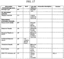
- FIGs. 16 and 17 respectively show examples of parameters included in the MC and MR messages.
- the RAN 20' sends a location information message including data included in the MR and internally acquired RTT (Round Trip Time) to the radio operating device 30 and stores the location information message therein. Meanwhile, the RAN 20' analyzes the MR, and then, if information of B sector that is a target sector exists in a neighbor list, the RAN 20' instructs channel allocation to a corresponding Node_B, and then sends an Active Set Update message to the MS 10 after the channel allocation.
- RTT Red Trip Time
- the radio operating device 30 transmits the location information message, sent from the RAN 20' and stored therein, to the traffic information analyzing device 40.
- the traffic information analyzing device 40 conducts a measurement process that analyzes location information of the MS 10 and then calculates traffic information of the MS such as a moving distance and a moving speed.
- the traffic information analyzing device 40 calculates a distance between Node_Bs by obtaining Node_B latitude/longitude data corresponding to the location information of the MS 10, and then calculates a moving distance and a speed of each measurement region by recognizing a current location of the MS using parameters such as RTT, PSC, Cell ID, and UE Position, included the location information message.
- the MS 10 receiving the Active Set Update message acquires a channel of the Node_B B and sends an Active Set Update Complete message to the RAN 20', the handover process is completed.
- FIG. 18 shows a process of acquiring location information of a mobile station by substituting Event MC of FIG. 15 with Periodic MC.
- RAN 20' sends a Periodic MC message to MS 10
- the MS 10 sends a Periodic MR to the RAN 20' at a predetermined period correspondingly.
- the RAN 20' When receiving the Periodic MR, the RAN 20' periodically transmits a location information message including data included in MR and internally acquired RTT to the radio operating device 30 and stores the location information message therein, and also performs the handover process as mentioned above.
- the radio operating device 30 sends the location information message, sent from the RAN 20' and stored therein, to the traffic information analyzing device 40.
- the traffic information analyzing device 40 conducts the measurement process as mentioned above to analyze location information of the MS 10 and calculate traffic information of the MS such as a moving distance and a moving speed.
- FIG. 19 shows a process of acquiring location information of a mobile station using Periodic MC and Event MC.
- the RAN 20' sends a Periodic MC message to MS 10
- the MS 10 sends a Periodic MR to the RAN 20' at a predetermined period correspondingly, and the RAN 20' periodically transmits a location information message including data included in MR and internally acquired RTT to the radio operating device 30 and stores the location information message therein.
- the RAN 20' analyzes the Event MR message, instructs channel allocation to a corresponding Node_B in case information of B sector that is a target sector exists in a neighbor list, and then sends an Active Set Update message to the MS 10 after the channel allocation so that a following handover may be processed.
- FIG. 20 shows a process of acquiring location information of a mobile station using UE (User Equipment) Positioning MC.
- UE User Equipment
- the RAN 20' sends a UE Positioning MC message to MS 10
- the MS 10 sends MR including a moving distance measurement parameter provided to GPS loaded therein to the RAN 20'
- the RAN 20' sends a location information message including latitude/longitude data included in the MR and internally acquired RTT to the radio operating device 30 and stores the location information message therein.
- the RAN 20' may controls the MS 10 to make an event report or a periodic report according to a specific moving distance by means of UE Positioning MC.
- FIG. 21 shows a process of providing a location information message according to a period set in RNC (Radio Network Controller) 22' itself of the RAN 20' during calling, namely in a call-established state.
- the RNC 22' periodically sends a location information message including RTT data provided from Node_B and so on to the radio operating device 30.
- the RTT data may be acquired through the process shown in FIG. 22 . That is, the RNC 22' of the RAN 20' sends a Dedicated Measurement Initiation Request message for RTT to Node_B 21' conducting the corresponding service, and receives a Dedicated Measurement Report sent from the Node_B 21' correspondingly.
- This process should be conducted for Node_B to which a call channel is established with MS before the location information message is sent to the radio operating device 30.
- the acquired RTT is sent to the radio operating device 30 with being included in the location information message, and then stored therein. After that, the location information message is sent to the traffic information analyzing device 40 and goes through the traffic information measurement process in the same way as above.
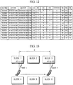
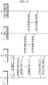
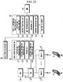
- FIG. 23 shows a traffic information measuring system according to the second embodiment of the present invention, which is provided to execute the traffic information measuring method explained above.
- the traffic information measuring system includes a radio operating device 30 connected to RAN 20' of an asynchronous WCDMA network to acquire and store location information of MS 10, and a traffic information analyzing device 40 for receiving the location information of the MS 10 from the radio operating device 30 to measure traffic information.
- the RAN 20' includes Node_B 21' for taking charge of RF sending/receiving interface for MS 10, and RNC 22' for processing setting-up of radio channels, handover and so on to manage radio resources of the Node_B 21', and the RAN 20' is connected to MSC 25 (Mobile service Switching Center) that is an essential part of a network subsystem.
- MSC 25 Mobile service Switching Center
- the RAN 20' sends a location information message including parameter data capable of tracking location of the MS, which is included in RTT data of MS sent from the Node_B 21' according to the request of the RNC 22' of the RAN 20' or Event MR, Periodic MR or UE Positioning MR collected during handover, to the radio operating device 30.
- the location information message includes parameters such as Msg ID, Seq ID, Mobile ID, MSC, RNC, Node_B, SEC, PSC, RTT, Position Distance and so on, as shown in FIG. 24 .
- parameters such as MSC, RNC, Node_B, SEC and PSC may be calculated utilizing Cell ID or PSC obtained from MR.
- the radio operating device 30 includes an activation processing unit 31, a location information acquiring unit 32, a storing unit 33 and a location information providing unit 34.
- This radio operating device 30 may be constructed based on a common O&M (Operation and Management) server that manages a RAN 20' in an asynchronous WCDMA network or a dedicated management server that provides a corresponding function.
- O&M Operaation and Management
- the activation processing unit 31 endows a location information collecting function by selectively activating a specific sub-cell under the control of the traffic information analyzing device 40. That is, the activation processing unit 31 gives a function of minimizing loads on the system during the location information collecting process by activating specific MSC, RNC, Node_B, SEC and FA among a plurality of systems composing an asynchronous WCDMA network.
- the location information acquiring unit 32 receives the location information message sent from the RNC 22' of the RAN 20' and stores the location information message to the storing unit 33.
- the location information message may be periodically stored during calling.
- the location information message may be stored whenever the location information message is sent to the location information acquiring unit 32 after the Event MR, Periodic MR or UE Positioning MR is received to the RNC 22', or stored at a period previously set in the RNC.
- the location information providing unit 34 sends the location information message stored in the storing unit 33 to the traffic information analyzing device 40 upon request of the traffic information analyzing device 40 or by itself.
- the traffic information analyzing device 40 interworking with the radio operating device 30 includes an activation controlling unit 41, a message receiving unit 42, a NMS (Network Management System) interworking unit 43, a measuring unit 44 and a mapping processing unit 45.
- NMS Network Management System
- the activation controlling unit 41 controls the activation processing unit 31 of the radio operating device 30 so that a location information message collecting function is endowed to a specific sub-cell among sub-cells of an asynchronous WCDMA network.
- the message receiving unit 42 takes charge of receiving the location information message sent by the location information providing unit 34 of the radio operating device 30.
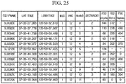
- the NMS interworking unit 43 interworks with a common NMS (Network Management System) 50 taking charge of overall operation of an asynchronous WCDMA network to acquire latitude/longitude data of Node_B covering the MS, PSC information, direction of antenna, and relay latitude/longitude data.
- FIG. 25 shows examples of latitude/longitude information of Node_B, and PSC information divided in Node_B and allocated to each sub-cell.
- the measuring unit 44 analyzes location information of MS 10 by using the location information message received in the message receiving unit 42, and calculates traffic information of the MS 10 including a moving speed of each measurement region. That is, the measuring unit 44 calculates an absolute distance between Node_Bs by using the Node_B latitude/longitude data obtained by the NMS interworking unit 43, and calculates a moving distance and a speed of each measurement region by recognizing a current location of the MS using RTT, PSC, Cell ID, UE Position and so on, included in the location information message. In addition, the measuring unit 44 may correct location of the MS by utilizing latitude/longitude of relay.
- the mapping processing unit 45 conducts a function of mapping and displaying the traffic information of the MS such as a moving distance and a speed, calculated by the measuring unit 44, on a road map.
- the road map is commonly provided by means of interworking with a common road map DB server 60.
- FIG. 26 shows an example of a location information message acquired utilizing Periodic MR.
- the RAN 20' may set a sending period in the range of about 0.25 to 640sec.
- location information messages for the events 1 and 2 include parameters as shown in FIG. 26 , assuming that a sending period of Periodic MR is 20 seconds, a distance between Node_Bs A and B is about 500m, and an analyzing unit of RTT is 1 chip (78.125m).
- the location information message shown in FIG. 26 corresponds to the case that RTT information is acquired, and thus the traffic information analyzing device 40 receives the location information message provided from the RAN 20' and stored in the radio operating device 30, and then analyzes RTT to recognize location of MS.
- a location of MS at the event 1 is recognized to be on a road adjacent to Node_B A by calculating a direction of a sector antenna of Node_B A, a direction of a sector antenna of Node_B B, and a point spaced apart from the Node_B A by 1 chip and spaced apart from the Node_B B by 6 chip, utilizing mechanical technique such as a trigonometric function.
- a location of MS at the event 2 is recognized to be on a road adjacent to Node_B B by calculating a direction of the sector antenna of Node_B A, a direction of the sector antenna of Node_B B, and a point spaced apart from the Node_B A by 5 chip and spaced apart from the Node_B B by 1 chip, utilizing mechanical technique such as a trigonometric function.
- a moving distance d between both events may be calculated, and the moving distance d is calculated to be 5 chips (about 390m) in this example.
- the MS is analyzed to move at a speed of about 70 km/Hour ( ⁇ 390m/20sec ⁇ 3600 sec/Hour).
- FIG. 27 shows an example of a location information message acquired utilizing UE Positioning MR.
- FIG. 27 shows the case that UE Positioning MC is set as an event location report according to a specific moving distance.
- BEST_PSC data among parameters included in the location information message or latitude/longitude data included in the US Positioning MR, an advancing direction of a vehicle may be deduced from the Node_B A to the Node_B B, and roads covered by the Node_B may be matched on a road map.
- FIG. 28 shows an example of a location information message acquired utilizing Periodic MR. This example corresponds to a case that RTT information cannot be acquired in FIG. 26 .
- traffic information may be measured using PSC or Cell ID based on BEST_PSC, and it is preferred to average a lot of analyzed data so as to minimize error.
- location information is collected utilizing a measurement message exchanged between a mobile station and a CDMA network, so it is possible to acquire location information of all mobile stations that receive communication service from the CDMA network and also analyze their traffic information, and also it is possible to construct a system utilizing an existing CDMA network, thereby capable of reducing installation and management costs.
- the present invention may endow a location information collecting function by activating a specific system of the CDMA network, it is possible to prevent overload on the system when collecting location information.
Landscapes
- Engineering & Computer Science (AREA)
- Computer Networks & Wireless Communication (AREA)
- Signal Processing (AREA)
- Chemical & Material Sciences (AREA)
- Analytical Chemistry (AREA)
- Physics & Mathematics (AREA)
- General Physics & Mathematics (AREA)
- Mobile Radio Communication Systems (AREA)
Claims (14)
- Verfahren zum Messen von Verkehrsinformationen in Bezug auf eine Bewegung einer Mobilstation, MS, das von einer Verkehrsinformationsanalysevorrichtung (40) durchgeführt wird, die mit einer Funkbetriebsvorrichtung (30) zusammenarbeitet, die mit einem Basisstationssubsystem, BSS (20), eines synchronen Code-Division-Multiple-Access-, CDMA, Netzwerks verbunden ist, wobei das BSS (20) eine Basissende- und - empfangsstation, BTS (21), die eine Kommunikationsschnittstelle zu einer Mobilstation, MS (10), besitzt, und eine Basisstationssteuerung, BSC (22), die Funkressourcen der BTS (21) verwaltet, umfasst, wobei das Verfahren die Schritte aufweist:Erhalten einer Standortinformationsnachricht der MS (10), die von der BSC (22) des BSS (20) bereitgestellt, in der Funkbetriebsvorrichtung (30) gespeichert und von der BSC (22) an die Verkehrsinformationsanalysevorrichtung (40) auf Anforderung der Verkehrsinformationsanalysevorrichtung (40) oder der BSC (22) selbst gesendet wird;Analysieren der Standortinformation der MS (10) unter Verwendung der Standortinformationsnachricht, wobei die Standortinformation eine periodisch von der BTS (21) gesendete RTD der MS (10) und eine Pseudo Noise_Phase-, PN_PHASE, Information enthält, die aus einer Periodic-Pilot-Strength-Measurement-Message, PPSMM, einer Pilot-Measurement-Strength-Message, PSMM, oder einer Pilot-Measurement-Report-Message, PMRM, die an der BTS während der Übergabe gesammelt wird, erhalten wird; undBerechnen einer Verkehrsinformation der MS (10) einschließlich einer Bewegungsgeschwindigkeit der MS (10) in jeder Messregion durch Verwenden der analysierten Standortinformation,dadurch gekennzeichnet, dass der folgende Schritt vor dem Schritt des Erhaltens ausgeführt wird:Steuern durch die Verkehrsinformationsanalysevorrichtung (40) der Funkbetriebsvorrichtung (30) zum selektiven Aktivieren einer Standortinformations-Sammelfunktion einer bestimmten Unterzelle von Unterzellen des synchronen CDMA-Netzwerks zum Minimieren von Belastungen auf das System während des Sammelns von Standortinformationen durch Aktivieren einer spezifischen Mobilfunkdienstvermittlungsstelle, MSC, einer Basisstationssteuerung, BSC, einer Basis-Transceiver-Station, BTS, eines Sektors, SEC, und einer MS-Dienstfrequenz, FA, unter einer Vielzahl von Systemen, die das synchrone CDMA-Netzwerk bilden,wobei die Verkehrsinformationsanalysevorrichtung (40) ausführt:Erlangen von Breiten-/Längengraddaten der BTS, die die MS-, Pseudo Noise-, PN, Information, die Antennenausrichtungs- und Weiterleitungs-Breiten-/Längengraddaten durch Zusammenarbeit mit dem Netzwerkverwaltungssystem, NMS, abdecken; undBerechnen einer Bewegungsdistanz und einer Bewegungsgeschwindigkeit der MS (10) in jeder Messregion durch Berechnen einer Distanz zwischen BTSs (21) unter Verwendung der BTS-Breiten-/Längengraddaten, die der im Analyseschritt analysierten Standortinformation der MS (10) entsprechen, undErkennen eines aktuellen Standorts der MS (10) unter Verwendung von zumindest der PN_PHASE oder eines Round Trip Delays, RTD, die in der Standortinformationsnachricht enthalten sind.
- Verfahren zum Messen von Verkehrsinformationen nach Anspruch 1, bei dem die Standortinformationsnachricht eine PN_PHASE umfasst, die von einem PSMM oder einem PMRM erhalten wird, die von der MS (10) an eine Unterzelle gesendet und dann an die BSC (22) und RTD geliefert wird, die von der Unterzelle an die BSC gesendet wird (22).
- Verfahren zum Messen von Verkehrsinformationen nach Anspruch 2, bei dem die Standortinformationsnachricht von der BSC (22) zu der Funkbetriebsvorrichtung (30) in der BSC (22) immer dann gespeichert wird, wenn das PPSMM, PSMM oder PMRM in der BSC (22) empfangen wird.
- Verfahren zum Messen von Verkehrsinformationen nach Anspruch 2, bei dem die Standortinformationsnachricht von der BSC (22) zu der Funkbetriebsvorrichtung (30) in der BSC (22) gemäß einer in der BSC (22) selbst eingestellten Periode gespeichert wird.
- Verfahren zum Messen von Verkehrsinformationen nach Anspruch 1, bei dem das Berechnen des Weiteren aufweist:Zuordnen der berechneten Verkehrsinformationen zu einer Straßenkarte.
- Verkehrsinformationsmesssystem, aufweisend eine Verkehrsinformationsanalysevorrichtung (40) und eine oder mehrere Funkbetriebsvorrichtungen (30) zum Messen von Verkehrsinformationen in Bezug auf eine Bewegung einer Mobilstation, MS (10), unter Verwendung der MS, wobei die Verkehrsinformationsanalysevorrichtung (40) aufweist:eine Nachrichtenempfangseinheit (42) zum Erhalten einer Standortinformationsnachricht der MS (10), die von einem Basisstationssubsystem, BSS (20), eines synchronen Code-Division-Multiple-Access-, CDMA, Netzwerks bereitgestellt, in einer Funkbetriebsvorrichtung (30) gespeichert und durch das BSS (20) an die Verkehrsinformationsanalysevorrichtung (40) auf Anforderung der Verkehrsinformationsanalysevorrichtung (40) oder der BSS (20) selbst gesendet wird, wobei die BSS (20) eine Basissende- und -empfangsstation, BTS (21), enthält, die eine Kommunikationsschnittstelle zu der Mobilstation, MS (10), und eine Basisstationssteuerung, BSC (22), zum Verwalten von Funkressourcen der BTSs (21) aufweist;eine Messeinheit (44) zum Analysieren von Standortinformationen der MS (10) unter Verwendung der Standortinformationsnachricht, wobei die Standortinformation eine Round Trip Delay, RTD, der MS (10), die periodisch von der BTS (21) gesendet wird, und die Pseudo-Noise_Phase-, PN_PHASE, Information, enthält, die aus einer Periodic-Strength-Measurement-Message, PPSMM, einer Pilot-Strength-Measurement-Message, PSMM, oder einer Pilot-Measurement-Report-Message, PMRM, erhalten wird, die an der BTS während einer Übergabe gesammelt werden, und zum Berechnen von Verkehrsinformationen in Bezug auf die Bewegung der MS (10) einschließlich einer Bewegungsgeschwindigkeit der MS (10) in jedem Messbereich;eine Netzwerkverwaltungssystem-, NMS, Zusammenarbeitseinheit (43) zum Erhalten von Breiten-/Längengraddaten einer Basissende- und -empfangsstation, BTS, die MS, Pseudo Noise-, PN, Information, Antennenausrichtungs- und Weiterleitungs-Breiten-/Längengraddaten durch Zusammenarbeiten mit dem NMS abdecken;dadurch gekennzeichnet, dass die Verkehrsinformationsanalysevorrichtung (40) des Weiteren aufweist:eine Aktivierungssteuereinheit (41) zum Steuern der Funkbetriebsvorrichtung (30) zum selektiven Aktivieren einer Standortinformations-Sammelfunktion einer bestimmten Unterzelle von Unterzellen des synchronen CDMA-Netzwerks zum Minimieren von Belastungen auf das System während des Informationssammelprozesses durch Aktivieren einer spezifischen Mobildienstvermittlungsstelle, MSC, eines BSC, eines Sektors, SEC, und einer MS-Dienstfrequenz, FA, unter mehreren Systemen, die das synchrone CDMA-Netzwerk bilden, wobei die Messeinheit (44) ausgebildet ist, eine Distanz zwischen BTSs (21) unter Verwendung der BTS-Breiten-/Längengraddaten zu berechnen, und eine Bewegungsdistanz und eine Bewegungsgeschwindigkeit der MS (10) in jeder Messregion durch Berechnen einer Distanz zwischen den BTSs (21) unter Verwendung der BTS-Breiten-/Längengraddaten zu berechnen, die der Standortinformation der in der Messeinheit (44) analysierten MS (10) entsprechen, und einen aktuellen Standort der MS (10) unter Verwendung von zumindest der PN_PHASE oder der RTD zu erkennen, die in der Standortinformationsnachricht enthalten sind.
- Verkehrsinformationsmesssystem nach Anspruch 6, bei dem die Standortinformationsnachricht eine PN_PHASE enthält, die von PPSMM, PSMM oder PMRM, die von der MS (10) an eine entsprechende Unterzelle gesendet und an die BSC (22) des BSS (20) geliefert werden, und der RTD erhalten wird, die von der Unterzelle an die BSC (22) gesendet wird.
- Verkehrsinformationsmesssystem nach Anspruch 6, des Weiteren aufweisend eine Abbildungsverarbeitungseinheit (45), die angepasst ist, um die berechneten Verkehrsinformationen auf eine Straßenkarte abzubilden, indem sie mit einem Straßenkartendatenbank-, DB, Server (60), zusammenarbeitet.
- Verfahren zum Messen von Verkehrsinformationen, das von einer Verkehrsinformationsanalysevorrichtung (40) ausgeführt wird, die mit einer Funkbetriebsvorrichtung (30) zusammenarbeitet, die mit einem Funkzugriffsnetzwerk, RAN (20'), eines asynchronen Wideband-Code-Division-Multiple-Access-, WCDMA, Netzwerks verbunden ist, das einen Node_B (21') mit einer Kommunikationsschnittstelle zu einer Mobilstation, MS (10), und eine Funknetzwerksteuerung, RNC (22), zum Verwalten von Funkressourcen des Node_B enthält, wobei das Verfahren die Schritte aufweist:Erhalten einer Standortinformationsnachricht von einer Mobilstation, MS (10), die von der RNC (22) des RAN (20') bereitgestellt, in der Funkbetriebsvorrichtung (30) gespeichert und durch die RNC (22) an die Funkbetriebsvorrichtung (30) auf Anforderung eines Ereignismessberichts, MR, eines periodischen MR oder eines UE-Positionierungs-MR, die während einer Übergabe gesammelt werden, oder durch die RNC (22) selbst gesendet wird;Analysieren der Standortinformation der MS, (10), durch Verwenden der Standortinformationsnachricht, wobei die Standortinformation RTT-Daten der MS (10) enthält, die von dem Node_B (21') gesendet werden; undBerechnen von Verkehrsinformationen in Bezug auf die Bewegung der MS (10) einschließlich einer Bewegungsgeschwindigkeit der MS (10) in jeder Messregion unter Verwendung der analysierten Standortinformation,dadurch gekennzeichnet, dass der folgende Schritt vor dem Schritt des Erhalten ausgeführt wird:Steuern durch die Verkehrsinformationsanalysevorrichtung (40) der Funkbetriebsvorrichtung (30) zum selektiven Aktivieren einer Standortinformations-Sammelfunktion einer spezifischen Unterzelle von Unterzellen des asynchronen WCDMA-Netzwerks zum Minimieren von Belastungen auf das System während des Sammelns von Standortinformationen durch Aktivieren einer spezifischen Mobilfunkdienstvermittlungsstelle, MSC, eines RNC, eines Node_B, eines Sektors, SEC, und einer MS Dienstfrequenz, FA, unter einer Vielzahl von Systemen, die das asynchrone WCDMA-Netzwerk bilden,
wobei die Standortinformationsnachricht einen primären Scrambling-Code, PSC, oder eine Cell ID, die von dem Ereignis-MR erhalten wird, oder einen periodischen MR, der von der MS (10) an die Unterzelle gesendet und dann an die RNC (22) geliefert wird, und einen Bewegungsdistanzmessparameter, der von dem Benutzergerät-, UE, Positionierungs-MR, erhalten wird, der von der MS (10) zu der Unterzelle gesendet und dann an die RNC (22) geliefert wird, und eine Round Trip Time, RTT, die zu der RNC (22) von der Unterzelle, in der die MS (10) während des Anrufs einen Dienst empfängt, gesendet wird, enthält, und wobei die Verkehrsinformationsanalysevorrichtung (40) eine Distanz zwischen Node_Bs unter Verwendung der von einem Netzwerkverwaltungssystem erhaltenen Breiten-/Längengraddaten eines Node_B berechnet, und eine Bewegungsdistanz und eine Bewegungsgeschwindigkeit der MS (10) in jedem Messbereich durch Berechnen einer Distanz zwischen Node_Bs (21) unter Verwendung der Node_B Breiten-/Längengraddaten berechnet, die der im Analyseschritt analysierten Standortinformation der MS (10) entsprechen, und einen aktuellen Standort der MS (10) unter Verwendung von zumindest der RTT, der PSC, der Cell ID und der UE-Position, die in der Standortinformationsnachricht enthalten sind, erkennt. - Verfahren zum Messen von Verkehrsinformationen nach Anspruch 9, bei dem die Standortinformationsnachricht von der RNC (22) zu der Funkbetriebsvorrichtung (30) in der RNC (22) gespeichert wird, wann immer der MR in der RNC (22) empfangen wird.
- Verfahren zum Messen von Verkehrsinformationen nach Anspruch 9, bei dem die Standortinformationsnachricht von der RNC (22) zu der Funkbetriebsvorrichtung (30) in der RNC (22) entsprechend einer in der RNC (22) selbst eingestellten Periode gespeichert wird.
- Verfahren zum Messen von Verkehrsinformationen nach Anspruch 9, bei dem das Berechnen des Weiteren aufweist:Zuordnen der berechneten Verkehrsinformationen zu einer Straßenkarte.
- Verkehrsinformationmesssystem, aufweisend eine Verkehrsinformationsanalysevorrichtung (40) und eine oder mehrere Funkbetriebsvorrichtungen (30) zum Messen von Verkehrsinformationen unter Verwendung einer Mobilstation, MS, wobei die Verkehrsinformationsanalysevorrichtung (40) aufweist:eine Nachrichtenempfangseinheit (42), die angepasst ist, um eine Standortinformationsnachricht der MS (10) zu erhalten, die von einer Funknetzwerksteuerung, RNC (22), eines Funkzugangsnetzwerks, RAN, (20') eines asynchronen Wideband-Code-Division-Multiple-Access-, WCDMA, Netzwerks bereitgestellt, in einer Funkbetriebsvorrichtung (30) gespeichert, und durch die RNC (22) an die Funkbetriebsvorrichtung (30) auf Anforderung eines Ereignismessberichts, MR, eines periodischen MR oder eines UE-Positionierungs-MR, die während einer Übergabe gesammelt werden, oder durch den RNC (22) selbst gesendet wird, wobei RAN (20') einen Node_B (21') enthält, der angepasst ist, die RF-Sende- und -Empfangsschnittstelle für die MS (10) zu übernehmen, und wobei die RNC (22') angepasst ist, das Setup für die Funkkanäle durchzuführen, sowie eine Übergabe zum Verwalten von Funkressourcen des Node_B (21');eine Messeinheit (44), die angepasst ist, eine Standortinformation der MS (10) unter Verwendung der Standortinformationsnachricht zu analysieren, wobei die Standortinformation RTT-Daten der MS (10) enthält, die von dem Node_B (21') gesendet werden; und Verkehrsinformationen in Bezug auf die Bewegung der MS (10) einschließlich einer Bewegungsgeschwindigkeit der MS (10) in jedem Messbereich zu berechnen;dadurch gekennzeichnet, dass die Verkehrsinformationsanalysevorrichtung (40) des Weiteren aufweist:eine Aktivierungssteuereinheit (41) zum Steuern der Funkbetriebsvorrichtung (30) zum selektiven Aktivieren einer spezifischen Unterzelle unter Unterzellen des asynchronen WCDMA-Netzwerks zum Minimieren von Belastungen auf das System während des Standortinformations-Sammelprozesses durch Aktivieren einer spezifische Mobildienstvermittlungsstelle, MSC, einer RNC, eines Node_B, eines Sektors, SEC, und einer MS-Dienstfrequenz, FA, unter einer Vielzahl von Systemen, die das asynchrone WCDMA-Netzwerk bilden; undeine Netzwerkverwaltungssystem-, NMS, Zusammenarbeitseinheit (43), die angepasst ist, Node_B-Breiten-/Längengraddaten, eine Primär-Scramblingcode-, PSC, Information, Antennenausrichtungs- und Weiterleitungs-Breiten-/Längengraddaten durch Zusammenarbeit mit dem NMS zu erhalten, wobei die Messeinheit (44) ausgelegt ist, eine Distanz zwischen Node_Bs unter Verwendung der Node_B Breiten-/Längengraddaten zu berechnen, und eine Bewegungsdistanz und eine Bewegungsgeschwindigkeit der MS (10) in jeder Messregion durch Berechnen einer Distanz zwischen Node_Bs (21) unter Verwendung der Node_B-Breiten-/Längengraddaten zu berechnen, die der Standortinformation der in der Messeinheit (44) analysierten MS (10) entsprechen, und einen aktuellen Standort der MS (10) unter Verwendung von zumindest der Round Trip Time, RTT, der PSC, der Cell ID und der Benutzergerät-, UE, Position, die in der Standortinformationsnachricht enthalten sind, zu erkennen.
- Verkehrsinformationsmesssystem nach Anspruch 13, des Weiteren aufweisend eine Abbildungsverarbeitungseinheit (45), die angepasst ist, um die berechneten Verkehrsinformationen auf einer Straßenkarte abzubilden, indem sie mit einem Straßenkarten-DB-Server (60) zusammenarbeitet.
Applications Claiming Priority (3)
| Application Number | Priority Date | Filing Date | Title |
|---|---|---|---|
| KR1020060025345A KR100817413B1 (ko) | 2006-03-20 | 2006-03-20 | 동기식 cdma망을 이용한 교통정보 측정 방법 및 그시스템 |
| KR1020060025346A KR100779376B1 (ko) | 2006-03-20 | 2006-03-20 | 비동기식 wcdma망을 이용한 교통정보 측정 방법 및 그시스템 |
| PCT/KR2007/001366 WO2007108641A1 (en) | 2006-03-20 | 2007-03-20 | Method and system for measuring traffic information in cdma network |
Publications (3)
| Publication Number | Publication Date |
|---|---|
| EP2005404A1 EP2005404A1 (de) | 2008-12-24 |
| EP2005404A4 EP2005404A4 (de) | 2012-12-12 |
| EP2005404B1 true EP2005404B1 (de) | 2018-03-21 |
Family
ID=38522641
Family Applications (1)
| Application Number | Title | Priority Date | Filing Date |
|---|---|---|---|
| EP07715736.0A Active EP2005404B1 (de) | 2006-03-20 | 2007-03-20 | Verfahren und system zur messung von verkehrsinformationen in einem cdma-netzwerk |
Country Status (4)
| Country | Link |
|---|---|
| US (1) | US8175792B2 (de) |
| EP (1) | EP2005404B1 (de) |
| JP (1) | JP4897038B2 (de) |
| WO (1) | WO2007108641A1 (de) |
Families Citing this family (12)
| Publication number | Priority date | Publication date | Assignee | Title |
|---|---|---|---|---|
| KR100738920B1 (ko) * | 2006-04-19 | 2007-07-12 | 에스케이 텔레콤주식회사 | Psmm을 이용한 이동통신 단말기의 위치 측위 방법 및시스템 |
| JP4787792B2 (ja) * | 2007-06-18 | 2011-10-05 | 株式会社エヌ・ティ・ティ・ドコモ | 無線制御装置、無線通信システム、通信路設定方法 |
| JP5127933B2 (ja) * | 2008-01-02 | 2013-01-23 | インターデイジタル パテント ホールディングス インコーポレイテッド | セル再選択の方法および装置 |
| EP2129178A1 (de) * | 2008-05-06 | 2009-12-02 | Alcatel Lucent | Verfahren zur Zuweisung von Frequenzunterkanälen auf einer Luftschnittstelle eines drahtlosen Kommunikationssystems und entsprechendes Funkressourcenzuweisungsmodul |
| US8831618B2 (en) | 2009-07-15 | 2014-09-09 | Qualcomm Incorporated | Apparatus and method to perform fast neighbor list search during a transfer to a different RAT target system |
| CN102884818B (zh) | 2010-05-06 | 2016-03-02 | 诺基亚技术有限公司 | 控制通信系统中测量数据的收集的装置和方法 |
| CN102436762B (zh) * | 2011-09-20 | 2014-03-19 | 浙江大学城市学院 | 一种基于gprs/cdma无线网络的高速公路智能辅助诱导系统及其控制方法 |
| US20130084862A1 (en) * | 2011-10-03 | 2013-04-04 | Alcatel-Lucent Usa Inc. | Method Of Estimating Mobility Of User Equipment And A Wireless Device |
| US9723535B1 (en) * | 2014-11-10 | 2017-08-01 | Sprint Spectrum L.P. | Wireless network neighbor list optimization based on group delay metrics |
| CN106817508B (zh) | 2015-11-30 | 2019-11-22 | 华为技术有限公司 | 一种同步对象确定方法、装置和系统 |
| GB2565536A (en) * | 2017-08-10 | 2019-02-20 | Nec Corp | Communication system |
| FR3110751A1 (fr) * | 2020-05-25 | 2021-11-26 | Psa Automobiles Sa | Procédé d’estimation du trafic automobile |
Family Cites Families (34)
| Publication number | Priority date | Publication date | Assignee | Title |
|---|---|---|---|---|
| JP2868113B2 (ja) * | 1994-02-21 | 1999-03-10 | エヌ・ティ・ティ移動通信網株式会社 | 移動通信による移動体位置検出方法 |
| JPH1040484A (ja) | 1996-07-19 | 1998-02-13 | Fujitsu General Ltd | 災害情報通報システム |
| US7903029B2 (en) * | 1996-09-09 | 2011-03-08 | Tracbeam Llc | Wireless location routing applications and architecture therefor |
| US6061337A (en) * | 1996-12-02 | 2000-05-09 | Lucent Technologies Inc. | System and method for CDMA handoff using telemetry to determine the need for handoff and to select the destination cell site |
| KR19990017557A (ko) | 1997-08-25 | 1999-03-15 | 이동률 | 이동차량 위치 송신장치 및 이를 이용한 교통정보 생성방법 |
| NO980890L (no) | 1998-02-27 | 1999-08-30 | Ericsson Telefon Ab L M | Måling av trafikk og transport |
| JPH11252630A (ja) | 1998-03-05 | 1999-09-17 | Nippon Telegr & Teleph Corp <Ntt> | 移動経路同定方法及びシステム及び移動経路同定プログラムを格納した記憶媒体 |
| KR100378645B1 (ko) | 1998-06-17 | 2007-11-30 | 인포뱅크 주식회사 | 셀단위망구조의이동통신망을이용한지역교통정보서비스방법및시스템 |
| JP2000311286A (ja) | 1999-04-28 | 2000-11-07 | Mitsubishi Electric Corp | 交通管制システム |
| KR100329644B1 (ko) * | 1999-12-02 | 2002-03-21 | 박종섭 | 이동통신 시스템에서 이동국 위치측정방법 및 이를 이용한핸드오프 수행방법 |
| JP4112140B2 (ja) * | 1999-12-03 | 2008-07-02 | 富士通株式会社 | 情報提供システムおよび情報受信装置 |
| US6681099B1 (en) * | 2000-05-15 | 2004-01-20 | Nokia Networks Oy | Method to calculate true round trip propagation delay and user equipment location in WCDMA/UTRAN |
| US20020128019A1 (en) * | 2000-11-01 | 2002-09-12 | Igal Ben-Yair | Online location finding system and method based on information extracted from a cellular mobile unit |
| KR100417347B1 (ko) | 2000-12-06 | 2004-02-05 | 주식회사 비즈모델라인 | 무선위치 측정시스템을 이용한 교통상황 정보제공 방법 |
| JP2003006509A (ja) | 2001-06-20 | 2003-01-10 | Hitachi Ltd | 通信装置,通信システム及び広告料算出方法 |
| KR100451896B1 (ko) | 2001-11-13 | 2004-10-12 | 주식회사 카포인트 | 실시간 교통정보 처리시스템 및 그 처리방법 |
| KR20030061493A (ko) | 2002-01-14 | 2003-07-22 | 팅크웨어(주) | 이동 통신망을 이용한 교통 정보 수집 시스템 |
| KR100834616B1 (ko) * | 2002-02-27 | 2008-06-02 | 삼성전자주식회사 | 이동 단말기의 위치결정 방법 |
| KR20030071362A (ko) | 2002-02-28 | 2003-09-03 | 주식회사 스타브이텍 | 네트워크 기반의 인공 지능형 교통정보 서비스 제공시스템 및 방법 |
| KR100863120B1 (ko) | 2002-05-11 | 2008-10-15 | 주식회사 케이티 | 무선랜을 이용한 교통정보 서비스 시스템 및 그 방법 |
| JP2003339070A (ja) | 2002-05-21 | 2003-11-28 | Hitachi Ltd | 位置検出システムおよび携帯端末およびサーバ |
| US7783312B2 (en) * | 2003-01-23 | 2010-08-24 | Qualcomm Incorporated | Data throughput improvement in IS2000 networks via effective F-SCH reduced active set pilot switching |
| KR20040077285A (ko) | 2003-02-28 | 2004-09-04 | 에스케이 텔레콤주식회사 | 위치 기반 서비스를 이용한 실시간 교통 정보 제공 방법및 시스템 |
| JP2004280553A (ja) * | 2003-03-17 | 2004-10-07 | Matsushita Electric Ind Co Ltd | 渋滞情報集配信システム、通信端末装置、渋滞情報集配信サーバ、移動体通信端末装置及び渋滞情報集配信方法 |
| KR100469714B1 (ko) | 2003-06-04 | 2005-02-02 | 삼성전자주식회사 | 실시간 교통데이터 수집 방법 및 그 장치 |
| JP2005115625A (ja) | 2003-10-07 | 2005-04-28 | Mitsubishi Automotive Logistics Co Ltd | 運行管理システム |
| KR20050078687A (ko) | 2004-01-31 | 2005-08-08 | 주식회사 케이티 | 무선랜브릿지를 이용한 교통정보 서비스 시스템 및 그 방법 |
| KR100573203B1 (ko) | 2004-03-17 | 2006-04-24 | 에스케이 텔레콤주식회사 | 지피에스 전파 음영 지역에서 위치 탐색기를 이용하여단말기의 위치를 측위하는 방법 및 시스템 |
| JP2005301643A (ja) | 2004-04-12 | 2005-10-27 | Matsushita Electric Ind Co Ltd | 交通情報生成システム |
| KR20050100121A (ko) | 2004-04-13 | 2005-10-18 | 에스케이 텔레콤주식회사 | 이동 단말기의 위치추적 정보를 이용한 교통정보수집시스템 및 방법 |
| JP2006033207A (ja) | 2004-07-14 | 2006-02-02 | Nec Corp | 位置情報提供システム、無線基地局装置及びそれらに用いる位置情報提供方法並びにそのプログラム |
| KR20060010961A (ko) | 2004-07-29 | 2006-02-03 | 에스케이 텔레콤주식회사 | Gps 이동 통신 단말기의 위치 데이터를 네비게이션장치에서 이용하는 방법 및 시스템 |
| US9072071B2 (en) * | 2008-05-19 | 2015-06-30 | Qualcomm Incorporated | Methods and systems for CDMA network switching notification in a WiMAX network |
| US8073463B2 (en) * | 2008-10-06 | 2011-12-06 | Andrew, Llc | System and method of UMTS UE location using uplink dedicated physical control channel and downlink synchronization channel |
-
2007
- 2007-03-20 EP EP07715736.0A patent/EP2005404B1/de active Active
- 2007-03-20 US US12/293,702 patent/US8175792B2/en active Active
- 2007-03-20 JP JP2009501353A patent/JP4897038B2/ja active Active
- 2007-03-20 WO PCT/KR2007/001366 patent/WO2007108641A1/en not_active Ceased
Non-Patent Citations (1)
| Title |
|---|
| None * |
Also Published As
| Publication number | Publication date |
|---|---|
| EP2005404A1 (de) | 2008-12-24 |
| JP2009530957A (ja) | 2009-08-27 |
| US8175792B2 (en) | 2012-05-08 |
| EP2005404A4 (de) | 2012-12-12 |
| WO2007108641A1 (en) | 2007-09-27 |
| JP4897038B2 (ja) | 2012-03-14 |
| US20090125220A1 (en) | 2009-05-14 |
Similar Documents
| Publication | Publication Date | Title |
|---|---|---|
| EP2005404B1 (de) | Verfahren und system zur messung von verkehrsinformationen in einem cdma-netzwerk | |
| CA2663190C (en) | Process for network characteristic data acquisition by regular users for supporting automated planning and optimization processes in cellular mobile radio networks | |
| US6061565A (en) | Mobile radio systems | |
| EP1992089B1 (de) | Verfahren und system zum messen der qualität eines drahtlosen netzwerks | |
| EP2066143B1 (de) | Funkzellenleistungsüberwachung und/oder -steuerung basierend auf den Endgerätpositionierungsdaten und Funkqualitätsparametern | |
| US9391599B2 (en) | Switching control system signaling techniques | |
| EP2517495B1 (de) | Verfahren und system zur automatischen deckungsbeurteilung für kooperierende drahtlose zugangsnetzwerke | |
| CN102210168A (zh) | 用于定位的无线电接入技术分集的使用 | |
| EP2533569A1 (de) | Verfahren zur Erkennung fehlender Nachbarn und zur Aktualisierung gegenwärtiger Nachbarn in drahtlosen Netzwerken | |
| EP2080390A2 (de) | Bestimmung des bewegungskontexts eines mobilen benutzerendgerätes in einem drahtlosen telekommunikationsnetzwerk | |
| CN101562846B (zh) | 盲切换的方法、系统及网络侧 | |
| GB2378614A (en) | Mobile location using timing information for repeated signals | |
| CN101405781B (zh) | 在cdma网络中测量交通信息的方法和系统 | |
| KR100779376B1 (ko) | 비동기식 wcdma망을 이용한 교통정보 측정 방법 및 그시스템 | |
| KR100766602B1 (ko) | Cdma망에서 왕복 지연 정보를 이용한 위치 추정 방법및 시스템 | |
| US10743207B2 (en) | Method of operating cellular mobile radio network | |
| KR101147713B1 (ko) | 광대역 씨디엠에이 단말기의 위치를 계산하기 위한 시스템및 방법 | |
| US10560863B1 (en) | Method of operating cellular mobile radio network | |
| KR101223066B1 (ko) | 광대역 씨디엠에이 단말기의 위치를 계산하기 위한 시스템및 방법 |
Legal Events
| Date | Code | Title | Description |
|---|---|---|---|
| PUAI | Public reference made under article 153(3) epc to a published international application that has entered the european phase |
Free format text: ORIGINAL CODE: 0009012 |
|
| 17P | Request for examination filed |
Effective date: 20081017 |
|
| AK | Designated contracting states |
Kind code of ref document: A1 Designated state(s): AT BE BG CH CY CZ DE DK EE ES FI FR GB GR HU IE IS IT LI LT LU LV MC MT NL PL PT RO SE SI SK TR |
|
| RIN1 | Information on inventor provided before grant (corrected) |
Inventor name: KIM, KYUNG-YUP Inventor name: KIM, SHIN-JAE |
|
| DAX | Request for extension of the european patent (deleted) | ||
| A4 | Supplementary search report drawn up and despatched |
Effective date: 20121113 |
|
| RIC1 | Information provided on ipc code assigned before grant |
Ipc: H04W 64/00 20090101ALI20121107BHEP Ipc: G08G 1/01 20060101AFI20121107BHEP |
|
| 17Q | First examination report despatched |
Effective date: 20141024 |
|
| STAA | Information on the status of an ep patent application or granted ep patent |
Free format text: STATUS: EXAMINATION IS IN PROGRESS |
|
| GRAP | Despatch of communication of intention to grant a patent |
Free format text: ORIGINAL CODE: EPIDOSNIGR1 |
|
| STAA | Information on the status of an ep patent application or granted ep patent |
Free format text: STATUS: GRANT OF PATENT IS INTENDED |
|
| GRAJ | Information related to disapproval of communication of intention to grant by the applicant or resumption of examination proceedings by the epo deleted |
Free format text: ORIGINAL CODE: EPIDOSDIGR1 |
|
| GRAP | Despatch of communication of intention to grant a patent |
Free format text: ORIGINAL CODE: EPIDOSNIGR1 |
|
| STAA | Information on the status of an ep patent application or granted ep patent |
Free format text: STATUS: EXAMINATION IS IN PROGRESS |
|
| GRAJ | Information related to disapproval of communication of intention to grant by the applicant or resumption of examination proceedings by the epo deleted |
Free format text: ORIGINAL CODE: EPIDOSDIGR1 |
|
| GRAP | Despatch of communication of intention to grant a patent |
Free format text: ORIGINAL CODE: EPIDOSNIGR1 |
|
| STAA | Information on the status of an ep patent application or granted ep patent |
Free format text: STATUS: GRANT OF PATENT IS INTENDED |
|
| INTG | Intention to grant announced |
Effective date: 20170926 |
|
| INTC | Intention to grant announced (deleted) | ||
| INTG | Intention to grant announced |
Effective date: 20171010 |
|
| GRAS | Grant fee paid |
Free format text: ORIGINAL CODE: EPIDOSNIGR3 |
|
| GRAL | Information related to payment of fee for publishing/printing deleted |
Free format text: ORIGINAL CODE: EPIDOSDIGR3 |
|
| GRAS | Grant fee paid |
Free format text: ORIGINAL CODE: EPIDOSNIGR3 |
|
| GRAA | (expected) grant |
Free format text: ORIGINAL CODE: 0009210 |
|
| STAA | Information on the status of an ep patent application or granted ep patent |
Free format text: STATUS: THE PATENT HAS BEEN GRANTED |
|
| AK | Designated contracting states |
Kind code of ref document: B1 Designated state(s): AT BE BG CH CY CZ DE DK EE ES FI FR GB GR HU IE IS IT LI LT LU LV MC MT NL PL PT RO SE SI SK TR |
|
| REG | Reference to a national code |
Ref country code: GB Ref legal event code: FG4D |
|
| REG | Reference to a national code |
Ref country code: CH Ref legal event code: EP |
|
| REG | Reference to a national code |
Ref country code: AT Ref legal event code: REF Ref document number: 981883 Country of ref document: AT Kind code of ref document: T Effective date: 20180415 |
|
| REG | Reference to a national code |
Ref country code: IE Ref legal event code: FG4D |
|
| REG | Reference to a national code |
Ref country code: DE Ref legal event code: R096 Ref document number: 602007054280 Country of ref document: DE |
|
| REG | Reference to a national code |
Ref country code: NL Ref legal event code: MP Effective date: 20180321 |
|
| PG25 | Lapsed in a contracting state [announced via postgrant information from national office to epo] |
Ref country code: CY Free format text: LAPSE BECAUSE OF FAILURE TO SUBMIT A TRANSLATION OF THE DESCRIPTION OR TO PAY THE FEE WITHIN THE PRESCRIBED TIME-LIMIT Effective date: 20180321 Ref country code: FI Free format text: LAPSE BECAUSE OF FAILURE TO SUBMIT A TRANSLATION OF THE DESCRIPTION OR TO PAY THE FEE WITHIN THE PRESCRIBED TIME-LIMIT Effective date: 20180321 Ref country code: LT Free format text: LAPSE BECAUSE OF FAILURE TO SUBMIT A TRANSLATION OF THE DESCRIPTION OR TO PAY THE FEE WITHIN THE PRESCRIBED TIME-LIMIT Effective date: 20180321 |
|
| REG | Reference to a national code |
Ref country code: LT Ref legal event code: MG4D |
|
| REG | Reference to a national code |
Ref country code: AT Ref legal event code: MK05 Ref document number: 981883 Country of ref document: AT Kind code of ref document: T Effective date: 20180321 |
|
| PG25 | Lapsed in a contracting state [announced via postgrant information from national office to epo] |
Ref country code: BG Free format text: LAPSE BECAUSE OF FAILURE TO SUBMIT A TRANSLATION OF THE DESCRIPTION OR TO PAY THE FEE WITHIN THE PRESCRIBED TIME-LIMIT Effective date: 20180621 Ref country code: GR Free format text: LAPSE BECAUSE OF FAILURE TO SUBMIT A TRANSLATION OF THE DESCRIPTION OR TO PAY THE FEE WITHIN THE PRESCRIBED TIME-LIMIT Effective date: 20180622 Ref country code: SE Free format text: LAPSE BECAUSE OF FAILURE TO SUBMIT A TRANSLATION OF THE DESCRIPTION OR TO PAY THE FEE WITHIN THE PRESCRIBED TIME-LIMIT Effective date: 20180321 Ref country code: LV Free format text: LAPSE BECAUSE OF FAILURE TO SUBMIT A TRANSLATION OF THE DESCRIPTION OR TO PAY THE FEE WITHIN THE PRESCRIBED TIME-LIMIT Effective date: 20180321 |
|
| PG25 | Lapsed in a contracting state [announced via postgrant information from national office to epo] |
Ref country code: RO Free format text: LAPSE BECAUSE OF FAILURE TO SUBMIT A TRANSLATION OF THE DESCRIPTION OR TO PAY THE FEE WITHIN THE PRESCRIBED TIME-LIMIT Effective date: 20180321 Ref country code: PL Free format text: LAPSE BECAUSE OF FAILURE TO SUBMIT A TRANSLATION OF THE DESCRIPTION OR TO PAY THE FEE WITHIN THE PRESCRIBED TIME-LIMIT Effective date: 20180321 Ref country code: NL Free format text: LAPSE BECAUSE OF FAILURE TO SUBMIT A TRANSLATION OF THE DESCRIPTION OR TO PAY THE FEE WITHIN THE PRESCRIBED TIME-LIMIT Effective date: 20180321 Ref country code: ES Free format text: LAPSE BECAUSE OF FAILURE TO SUBMIT A TRANSLATION OF THE DESCRIPTION OR TO PAY THE FEE WITHIN THE PRESCRIBED TIME-LIMIT Effective date: 20180321 Ref country code: EE Free format text: LAPSE BECAUSE OF FAILURE TO SUBMIT A TRANSLATION OF THE DESCRIPTION OR TO PAY THE FEE WITHIN THE PRESCRIBED TIME-LIMIT Effective date: 20180321 |
|
| PG25 | Lapsed in a contracting state [announced via postgrant information from national office to epo] |
Ref country code: AT Free format text: LAPSE BECAUSE OF FAILURE TO SUBMIT A TRANSLATION OF THE DESCRIPTION OR TO PAY THE FEE WITHIN THE PRESCRIBED TIME-LIMIT Effective date: 20180321 Ref country code: CZ Free format text: LAPSE BECAUSE OF FAILURE TO SUBMIT A TRANSLATION OF THE DESCRIPTION OR TO PAY THE FEE WITHIN THE PRESCRIBED TIME-LIMIT Effective date: 20180321 Ref country code: SK Free format text: LAPSE BECAUSE OF FAILURE TO SUBMIT A TRANSLATION OF THE DESCRIPTION OR TO PAY THE FEE WITHIN THE PRESCRIBED TIME-LIMIT Effective date: 20180321 |
|
| PG25 | Lapsed in a contracting state [announced via postgrant information from national office to epo] |
Ref country code: PT Free format text: LAPSE BECAUSE OF FAILURE TO SUBMIT A TRANSLATION OF THE DESCRIPTION OR TO PAY THE FEE WITHIN THE PRESCRIBED TIME-LIMIT Effective date: 20180723 |
|
| REG | Reference to a national code |
Ref country code: DE Ref legal event code: R097 Ref document number: 602007054280 Country of ref document: DE |
|
| PLBE | No opposition filed within time limit |
Free format text: ORIGINAL CODE: 0009261 |
|
| STAA | Information on the status of an ep patent application or granted ep patent |
Free format text: STATUS: NO OPPOSITION FILED WITHIN TIME LIMIT |
|
| PG25 | Lapsed in a contracting state [announced via postgrant information from national office to epo] |
Ref country code: DK Free format text: LAPSE BECAUSE OF FAILURE TO SUBMIT A TRANSLATION OF THE DESCRIPTION OR TO PAY THE FEE WITHIN THE PRESCRIBED TIME-LIMIT Effective date: 20180321 |
|
| 26N | No opposition filed |
Effective date: 20190102 |
|
| PG25 | Lapsed in a contracting state [announced via postgrant information from national office to epo] |
Ref country code: IT Free format text: LAPSE BECAUSE OF FAILURE TO SUBMIT A TRANSLATION OF THE DESCRIPTION OR TO PAY THE FEE WITHIN THE PRESCRIBED TIME-LIMIT Effective date: 20180321 |
|
| PG25 | Lapsed in a contracting state [announced via postgrant information from national office to epo] |
Ref country code: SI Free format text: LAPSE BECAUSE OF FAILURE TO SUBMIT A TRANSLATION OF THE DESCRIPTION OR TO PAY THE FEE WITHIN THE PRESCRIBED TIME-LIMIT Effective date: 20180321 |
|
| PG25 | Lapsed in a contracting state [announced via postgrant information from national office to epo] |
Ref country code: MC Free format text: LAPSE BECAUSE OF FAILURE TO SUBMIT A TRANSLATION OF THE DESCRIPTION OR TO PAY THE FEE WITHIN THE PRESCRIBED TIME-LIMIT Effective date: 20180321 |
|
| REG | Reference to a national code |
Ref country code: CH Ref legal event code: PL |
|
| GBPC | Gb: european patent ceased through non-payment of renewal fee |
Effective date: 20190320 |
|
| PG25 | Lapsed in a contracting state [announced via postgrant information from national office to epo] |
Ref country code: LU Free format text: LAPSE BECAUSE OF NON-PAYMENT OF DUE FEES Effective date: 20190320 |
|
| REG | Reference to a national code |
Ref country code: BE Ref legal event code: MM Effective date: 20190331 |
|
| PG25 | Lapsed in a contracting state [announced via postgrant information from national office to epo] |
Ref country code: LI Free format text: LAPSE BECAUSE OF NON-PAYMENT OF DUE FEES Effective date: 20190331 Ref country code: CH Free format text: LAPSE BECAUSE OF NON-PAYMENT OF DUE FEES Effective date: 20190331 Ref country code: IE Free format text: LAPSE BECAUSE OF NON-PAYMENT OF DUE FEES Effective date: 20190320 Ref country code: GB Free format text: LAPSE BECAUSE OF NON-PAYMENT OF DUE FEES Effective date: 20190320 |
|
| PG25 | Lapsed in a contracting state [announced via postgrant information from national office to epo] |
Ref country code: BE Free format text: LAPSE BECAUSE OF NON-PAYMENT OF DUE FEES Effective date: 20190331 Ref country code: FR Free format text: LAPSE BECAUSE OF NON-PAYMENT OF DUE FEES Effective date: 20190331 |
|
| PG25 | Lapsed in a contracting state [announced via postgrant information from national office to epo] |
Ref country code: TR Free format text: LAPSE BECAUSE OF FAILURE TO SUBMIT A TRANSLATION OF THE DESCRIPTION OR TO PAY THE FEE WITHIN THE PRESCRIBED TIME-LIMIT Effective date: 20180321 |
|
| PG25 | Lapsed in a contracting state [announced via postgrant information from national office to epo] |
Ref country code: MT Free format text: LAPSE BECAUSE OF NON-PAYMENT OF DUE FEES Effective date: 20190320 |
|
| PG25 | Lapsed in a contracting state [announced via postgrant information from national office to epo] |
Ref country code: IS Free format text: LAPSE BECAUSE OF FAILURE TO SUBMIT A TRANSLATION OF THE DESCRIPTION OR TO PAY THE FEE WITHIN THE PRESCRIBED TIME-LIMIT Effective date: 20180721 |
|
| PG25 | Lapsed in a contracting state [announced via postgrant information from national office to epo] |
Ref country code: HU Free format text: LAPSE BECAUSE OF FAILURE TO SUBMIT A TRANSLATION OF THE DESCRIPTION OR TO PAY THE FEE WITHIN THE PRESCRIBED TIME-LIMIT; INVALID AB INITIO Effective date: 20070320 |
|
| PGFP | Annual fee paid to national office [announced via postgrant information from national office to epo] |
Ref country code: DE Payment date: 20250214 Year of fee payment: 19 |
|
| REG | Reference to a national code |
Ref country code: DE Ref legal event code: R081 Ref document number: 602007054280 Country of ref document: DE Owner name: VALUE INNOVATION PARTNERS CO., LTD., KR Free format text: FORMER OWNER: KTFREETEL CO., LTD., SEOUL/SOUL, KR Ref country code: DE Ref legal event code: R082 Ref document number: 602007054280 Country of ref document: DE |