EP1904873B1 - Verfahren zur aufnahme und behandlung magnetischer daten mittels lokaler echtzeit aktualisierung - Google Patents
Verfahren zur aufnahme und behandlung magnetischer daten mittels lokaler echtzeit aktualisierung Download PDFInfo
- Publication number
- EP1904873B1 EP1904873B1 EP06779041.0A EP06779041A EP1904873B1 EP 1904873 B1 EP1904873 B1 EP 1904873B1 EP 06779041 A EP06779041 A EP 06779041A EP 1904873 B1 EP1904873 B1 EP 1904873B1
- Authority
- EP
- European Patent Office
- Prior art keywords
- map
- magnetometric
- magnetometric data
- gradient
- acquiring
- Prior art date
- Legal status (The legal status is an assumption and is not a legal conclusion. Google has not performed a legal analysis and makes no representation as to the accuracy of the status listed.)
- Active
Links
Images





Classifications
-
- G—PHYSICS
- G01—MEASURING; TESTING
- G01V—GEOPHYSICS; GRAVITATIONAL MEASUREMENTS; DETECTING MASSES OR OBJECTS; TAGS
- G01V3/00—Electric or magnetic prospecting or detecting; Measuring magnetic field characteristics of the earth, e.g. declination, deviation
- G01V3/08—Electric or magnetic prospecting or detecting; Measuring magnetic field characteristics of the earth, e.g. declination, deviation operating with magnetic or electric fields produced or modified by objects or geological structures or by detecting devices
- G01V3/081—Electric or magnetic prospecting or detecting; Measuring magnetic field characteristics of the earth, e.g. declination, deviation operating with magnetic or electric fields produced or modified by objects or geological structures or by detecting devices the magnetic field is produced by the objects or geological structures
-
- G—PHYSICS
- G01—MEASURING; TESTING
- G01V—GEOPHYSICS; GRAVITATIONAL MEASUREMENTS; DETECTING MASSES OR OBJECTS; TAGS
- G01V3/00—Electric or magnetic prospecting or detecting; Measuring magnetic field characteristics of the earth, e.g. declination, deviation
- G01V3/38—Processing data, e.g. for analysis, for interpretation, for correction
Definitions
- the present invention relates to a method for acquiring and processing magnetometric data by local updates and in real time on a map with at least two dimensions of magnetometric characteristics of a geographical area.
- Magnetometric data surveys carried out at sea make it possible to detect magnetic anomalies such as, for example, generated by mines or containers.
- the present method consists in measuring a complete set of magnetometric data along a trajectory traveled by the ship over a geographical area.
- the complete set of magnetometric data is interpolated on a 2D interpolation map.
- This first stage of treatment makes it possible to reconstruct the surface of the geographical area from the line corresponding to the trajectory of the ship (Estimation and spatial interpolation: Deterministic methods and geostatistical methods, Michel Arnaud and Xavier Emery, Hermes Science publications, Paris, 2000 Michael Rauth, Institute for Meteorology and Geophysics at the University of Vienna, These Grids, Geophysical Potential Fields from noisysy Scattered Data, 1998).
- a second processing step is applied to the data of the 2D interpolation card in order to exploit this data.
- the first method of treatment is called pole reduction.
- the second is called the calculation of the analytical signal.
- 2D maps may be incomplete and have "holes" after data processing or areas of potential interest may be a little too far from the vessel's path to have a map precise.
- the objective of the present invention is therefore to propose a method and a device for acquiring and processing magnetometric data allowing the representation, on a map with at least two dimensions, of magnetic characteristics in real time by local updates. on small samples of data.
- the invention also relates to a device for acquiring and processing magnetometric data for producing a card with at least two dimensions of magnetometric characteristics of a geographical zone comprising a magnetometric data measurement means producing a signal forming a card. magnetic anomalies, a processing unit of said signal producing a 2D reduction map at the poles and a 2D map of the analytical signal.
- the processing unit implements, locally and in real time, the method described above.
- the figure 1 is a schematic representation of a method of acquiring and processing magnetometric data according to the prior art.
- This method makes it possible to obtain a representation on a map with at least two dimensions of magnetometric characteristics of a geographical area.
- It comprises a step of measuring the intensity of the magnetic field 1 over a geographical area.
- This measurement step 1 produces a set of magnetometric data of intensity B (s) making it possible to form a georeferenced magnetic anomaly map 2 (s represents the curvilinear abscissa along the trajectory of the data survey).
- the geographical position of each measurement can be obtained by GPS or other positioning means.
- This acquisition method is called “global” because the complete set of magnetometric data is obtained after the acquisition step 1.
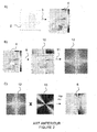
- a 2D interpolation calculation step 3, represented on the figure 2 A) is then applied to the set of magnetometric data of intensity B (s).
- minimum curvature is the one most commonly used for the processing of potential data (Magnetics, Gravimetry).
- This 2D interpolation method is effective for surfaces that do not exhibit abrupt variations.
- the method by solving a system of linear equations is well suited when the number of data to be processed is small and when the extent of the surface to be interpolated is large.
- the finite difference method is better suited when the number of data to be processed is large and when the surface to be interpolated is large.
- the high spatial frequencies At the beginning of the iterations, one obtains the high spatial frequencies. It is these frequencies that become accessible for the following processing steps. The lowest frequencies are obtained at the end if the calculation time is reasonable.
- interpolation 3 After the calculation of 2D interpolation 3 by one or other of the methods, we obtain a set of interpolated magnetometric data of intensity B (x, y), referenced according to the reference frames x and y on an interpolation card 2D 4.
- the set of interpolated magnetometric data forms a surface.
- the pitch of the card is 25 m in the example shown in the figures. It can be different.
- Two separate data processes can then be applied to the set of interpolated magnetometric data producing two distinct 2D maps. These two methods consist of Fourier filtering.
- the first possible method of treatment consists in applying a reduction calculation to poles 5 to all interpolated magnetometric data of intensity B (x, y) and more precisely to the spatial frequencies made accessible during the calculation of 2D interpolation, as mentioned above.
- the second method of treatment consists in applying a calculation of the analytical signal 7 to the set of interpolated magnetometric data of intensity B (x, y).
- An expansion operation 9 (bilinear interpolation) is first applied to the 2D interpolation card 4 ( Figure 2 B) ) which consists in making this map periodic and continuous on the edges. This is one of the necessary conditions for calculating the Fourier transform that follows. Another of the conditions was to fill in the "holes" of the map, which was done with the calculation of interpolation 2D 3.
- a two-dimensional Fourier transform 11 is then applied over the entire extended 2D map 10.
- a 2D map is obtained representing a set of data in the Fourier domain 12.
- this set of data is multiplied by a complex filter 13 in the Fourier domain, as shown in FIG. Figure 2 C) .
- Frtp represents the transfer function of the complex filter
- a two-dimensional Fourier transform 11 is then applied over the entire extended 2D map 10.
- a 2D map is obtained representing a set of data in the Fourier domain 12.
- Equation 2 is not accurate for latitudes less than 20 °. In practice to regularize this formula, we replace sin (Ip) by sin (la) for
- a mask 14 is applied to the 2D reduction map at the poles 6 in order to mask the areas that were not actually covered during the measurement campaign.
- a masked 2D pole reduction map is obtained, as shown in FIG. figure 3 E) .
- the mask 14 is obtained from the complete magnetic anomaly map 2.
- the mask is a map composed of 0 and 1 at the step of the 2D reduction map at the poles 6 which is 25 m in this example.
- y all the points of the map located at a distance less than a maximum radius are set to 1.
- the maximum radius is 5 times the pitch of the card is 125 m.
- This step comprises an operation of multiplication by a gradient filter X 16, a multiplication operation by a gradient filter Y 17, a multiplication operation by a gradient filter Z 18 applied in the Fourier domain to the data set of the domain of Fourier 12, each operation being applied alone to lead respectively to three cards 65, 66, 67. Each of these three cards 65, 66, 67 is then multiplied by the mask 14 obtained from the complete magnetic anomaly card. 2. Three masked maps are obtained, one of gradient X 19, another of gradient Y 20 and a third of gradient Z 21.
- the three cards 19, 20 and 21 are then composed so as to generate a single 2D map of the masked analytical signal 8.
- the measured magnetic field is a potential field.
- the field can be described by a function B (x, z) in 2 dimensions, with x coordinate along the profile and z depth.
- the derivatives dB / dx and dB / dz (dz directed downwards) are harmonic conjugate to each other. They are deduced from each other by the Hilbert transform.
- the complex signal B "(x, z) dB / dx + i dB / dz is therefore an analytical signal.
- the analytic signal modulus has vertical maxima of the magnetic sources.
- the magnetic anomaly map 2 is a georeferenced image, consisting of a matrix of elementary pixels. Each pixel is assigned a unique value calculated from the set of measurements located within the elementary geographical area represented by the pixel.
- the size of a pixel is a choice of the user that depends on the size of the anomalies he wants to observe, the computing power of the CPU and the measurement frequency of the magnetometer sensor.
- the measurement frequency of the sensor used for acquiring the maps of Figures 1 to 10 is around 10 Hz.
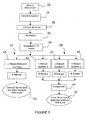
- the method for acquiring and processing magnetometric data comprises a step of locally updating the magnetic anomaly map in real time by an elementary measurement step 22 of the intensity of the magnetic field over a small geographical area, as represented on the figure 5 .
- An elementary series of magnetometric data associated with an updated pixel 23 is obtained.
- the elementary series of magnetometric data corresponds to a sample of georeferenced measurements and located within the same pixel. As soon as the pixel 23 is updated by the elementary series of magnetometric data, the different steps for obtaining the 2D maps are processed simultaneously.
- the geographical position of each measurement is associated in real time with GPS data taking into account the experimental and instrumental response times.
- GPS data and magnetometer data are dated with the same clock.
- a map creation step 32 is applied to these georeferenced data by placing them on a map referenced according to the reference frames x and y.
- This map has a step that is 25 m in the following example. This map is updated as soon as a pixel is updated. If it is the first pixel, the map is created by being centered on the geographical position of this first pixel. It has a default size of NxN points.
- a spatial decimation step 33 is applied to these data adapted to the resolution of the card. It consists of assigning a single intensity value and a single position for each pixel of the map. An updated magnetic anomaly map is obtained 34.
- a real-time local update step is applied to the 2D interpolation map 24 by applying the 2D interpolation calculation in the vicinity of the updated pixel 25 as shown in FIG. Figure 6 G) .
- the surface to be interpolated is pre-cut into sub-blocks that partially overlap.
- the algorithm determines in each sub-block the solution. In the overlapping areas the solution is obtained by linear combination of the solutions of each sub-block.
- the modified method 2 is preferably used. Adding a new point is essentially a local change.
- the algorithm searches for the solution locally by solving the finite difference equation by successive iterations in the vicinity of the updated pixel ( Smith WHFand Wessel P., 1990, Gridding with continuous curvature splines in tension: Geophysics: 55, 293-305 ).
- the procedure is described below.
- the only parameter accessible by the user is the step of the card.
- the first received pixel fixes the center of the card whose default size is 1024x1024 for example. For each new data, the coordinate of the destination pixel is calculated. If this pixel is not empty, we update its new value by the chosen method (closest neighbor, average, ). The overall mean of the field is also calculated as the measurement progresses.
- the algorithm of method 2 is applied to the vicinity of this pixel for a number of iterations fixed in advance Ni.
- the calculated average value serves as a starting value for empty pixels.
- the neighborhood size varies during the iterations.
- the neighborhood 25 is incremented by a fixed value L.
- a convolution mask is applied to the pixels to be calculated, which may have, for example, a size of 5 ⁇ 5 pixels.
- L and Ni are the only two parameters of the algorithm that must be adjusted according to the size of the card chosen by the operator and also according to the size of the objects to be analyzed (number of pixels). The larger the size of the objects, the more these parameters must be increased. A good estimate is in the order of Ni x L> 2x size of objects.
- the algorithm converges more and more rapidly as the map is constructed, since at each new point, the algorithm starts from a surface that is already a good approximation of the solution, except for the first points.
- the map is automatically enlarged as soon as a new measurement is outside a central area of the map defined by a size of N / 2xN / 2 pixels.
- the step of local and real-time updating of the 2D interpolation map can also be performed by any other type of local 2D interpolation method such as the nearest neighbor method, the polynomial interpolation method. , or the spline method ( Estimation and spatial interpolation: Deterministic methods and geostatistical methods, Michel Arnaud and Xavier Emery, Hermes Science publications, Paris, 2000 ; Gridding of Geophysical Potential Fields from noisysy Scattered Data, Michael Rauth, Institute of Meteorology and Geophysics, University of Vienna, These, 1998 ; Sambridge M., Braun J and McQueen, H., Geophysical J. International, 122, 837-857, Geophysical parameterization and interpolation of irregular data ; Akima H., 1970, J. Computing Machinery Association: 17, 589-602 ), without being limited.
- any other type of local 2D interpolation method such as the nearest neighbor method, the polynomial interpolation method.
- the spline method Estimation and
- a step of local and real-time updating of the 2D map of the analytical signal 29 is also applied by applying to the updated 2D interpolation map 26 the calculation of the analytical signal for the updated pixel 23 and in the vicinity of the updated pixel 25, as shown in the figures 7 , 10 and 11 .
- the neighborhood dimension of the updated pixel 25 is variable according to the processing step.
- the first method consists in applying a convolution mask in the spatial domain on the updated pixel 23 and in the vicinity of the updated pixel 25, on the non-masked pixels of the updated 2D interpolation card 26. This operation is done locally and in real time.
- the neighborhood size is twice the size of the convolution mask.
- Updated pixels are obtained on a map of magnetometric data reduced to the updated poles 28.
- the map of reduced magnetometric data at the updated poles 28 is then multiplied by the mask 14, obtained by the method represented on FIG. Figure 3 D) .
- An indexed masked magnetic data map 63 is obtained. This step is represented on the figure 6 I) .
- the size of the masks, the updated pixel 23 and the neighborhood of the updated pixel 25 are not scaled for reasons of representation.
- the size of the mask is determined by the spatial extent of the filter. In the case where the theoretical filter has a zero mean, it is important to keep this property on the mask. Therefore, the average value must be set to 0 if the theoretical average is zero.
- M (i, j) M1 (i, j) - ⁇ M1 (i, j)>.
- the size of the medium, on which the reduction mask at the pole 33 is applied is NxN pixels, with N> 64.
- the size of the mask 33 is 64x64.
- the size indicated above is a minimum size.
- the choice of the size of the masks is also a function of the sampling rate of the anomaly map and the size of the objects that one wants to observe. If D is the maximum size of the objects (the neighborhood of the modified pixel 25) that one wishes to analyze and dX the sampling step of the card, one must also take N such that N * dx> D.
- a gradient convolution mask X 34 is applied and then mask 14 to the 2D interpolation map 26 updated in the spatial domain.
- a filtered sub-image is obtained according to the X-referential 37, represented on the figure 7 .
- a gradient convolution mask Y 35 is applied and then the mask 14 to the 2D interpolation map updated 26 in the spatial domain.
- a sub filtered image is obtained according to the referential Y 38.
- a gradient convolution mask Z 36 is applied and then the mask 14 to the 2D interpolation map updated 26 in the spatial domain.
- a sub filtered image is obtained according to the Z reference system 39.
- a composition step 44 is then applied to the three filtered subframes 37, 38 and 39 to obtain updated pixels on an analytical magnetometer data card 30.
- the size of the Gradient X 34 and Y 35 mask support is Nx1 and 1xN respectively with N> 32.
- the size of the masks 34, 35, 36 is 64 ⁇ 64 pixels.
- the second method of updating 2D maps consists of extracting and processing subsets of the updated 2D interpolation card 26.
- the 2D interpolation card 26 is divided into subsets of maximum size 1024x1024 for example. This method allows the processing of large maps.
- the sub-assembly to be processed 50 comprises the updated pixel 23 and the neighborhood of the updated pixel 25.
- the size of the sub-assembly to be processed 50 corresponds to the size of the neighborhood of the updated pixel 25.
- a local and real-time update step of the 2D reduction map at the poles 27 is applied to the sub-assembly to be processed in the Fourier domain 62, as shown in FIG. figure 9K ). This step is applied to the frequencies made accessible by the 2D interpolation calculation.
- the step of local and real-time updating of the 2D reduction map at the poles 27 comprises a multiplication operation by a complex filter 51, obtained by the method described above.
- This complex filter 51 is applied in the Fourier domain to the subassembly to be treated 50.
- This operation is followed by a two-dimensional inverse Fourier transform followed by a multiplication by a sub-mask 64 corresponding to 1 ⁇ 4 of the mask 14. for the example of the figure 9 . More specifically, the sub-mask 64 corresponds to the zone represented by the sub-assembly to be treated 50. It is obtained by cutting and extracting this zone from the mask 14.
- a processed subassembly 52 is obtained. processed set 52 is masked.
- a recombination step 60 of the processed subset 52 is applied with the remainder of the subsets 61 which are also masked.
- the updated magnetism data map at the poles 28 is obtained.
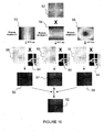
- the step of local and real-time updating of the 2D map of the analytical signal 29, represented on the figure 10 it comprises a multiplication operation by a gradient filter X 53, a multiplication operation by a Y gradient filter 54 and a multiplication operation by a gradient filter Z 55 applied in the Fourier domain to the subset to be processed 50.
- Each operation is applied alone in order to result in three cards in the Fourier domain.
- Each multiplication operation is followed by a two-dimensional inverse Fourier transform process applied to each of these cards so as to obtain three cards in the spatial domain 68, 69, 70. These three cards in the spatial domain 68, 69 , 70 are then multiplied by the sub-mask 64.
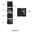
- a recombination step 60 of the processed subassembly 52 is then applied with the remainder of the subsets 61, as shown in FIG. figure 11 .
- the 2D map of the updated analytic signal 30 is obtained.
- a multiresolution operation can be applied between the 2D interpolation step and any of the local and real-time update stages of the 2D map. reduction at the poles 27 or the 2D map of the analytical signal 29. Several maps with several resolutions are produced simultaneously in order to accelerate convergence on the low frequencies.
- This deconvolution also allows the referencing of magnetic sources according to the reference frame z. We can then estimate in real time the depth of the sources during measurements.
- the invention also relates to a device for acquiring and processing magnetometric data for producing a card with at least two dimensions of magnetometric characteristics of a geographical area.
- It comprises a magnetometric data measuring means which produces a signal forming a magnetic anomaly map. It comprises a signal processing unit producing a 2D reduction map at the poles and a 2D map of the analytical signal.
- the processing unit implements, locally and in real time, the method of acquiring and processing magnetometric data described above.
- the magnetometric data measuring means may be a magnetometric sensor for generating magnetometric data of intensity B (s).
- It can include several scalar sensors so as to measure the intensity gradient of the magnetic field in one or more directions.
- It can comprise a vector magnetometric sensor for generating vector magnetometric data Bx (s), By (s) and Bz (s) which represent the three components of the magnetic field. These components make it possible to reconstruct the scalar signal B (s). Data processing can be simplified because it is possible to directly calculate gradient data from these components.
- the magnetometric data measurement means may advantageously be a gradiometer of the type which makes it possible to directly generate gradient data of at least one of the components of the gradient tensor of the Gx or Gy or Gz field.
- a gradiometer can advantageously be used to generate gradient data of at least one of the components of the gradient tensor of the Gx or Gy or Gz field and also magnetometric data of intensity B (s).
- a gradiometer for generating gradient data of at least one of the components of the gradient tensor of the Gx or Gy or Gz field and the vector magnetometric data Bx (s), By (s) and Bz (s).
- the invention proposes a method for acquiring and processing local magnetometer data, which makes it possible to analyze the results displayed on the 2D maps in real time, during the measurement campaign.
- the invention allows a considerable time saving and a reaction on the ground in real time.
- a container or a mine in the open sea can be located and removed immediately.
Landscapes
- Life Sciences & Earth Sciences (AREA)
- Engineering & Computer Science (AREA)
- Remote Sensing (AREA)
- Physics & Mathematics (AREA)
- Environmental & Geological Engineering (AREA)
- Geology (AREA)
- General Life Sciences & Earth Sciences (AREA)
- General Physics & Mathematics (AREA)
- Geophysics (AREA)
- Electromagnetism (AREA)
- Measuring Magnetic Variables (AREA)
Claims (17)
- Verfahren zur Aufnahme und Bearbeitung magnetometrischer Daten für die Darstellung mindestens zweier Dimensionen mit magnetometrischen Merkmalen einer geographischen Zone auf einer Karte, umfassend:- einen Schritt des Messens der Stärke des Magnetfeldes (1) in einer geographischen Zone, der eine Gesamtheit von magnetometrischen Daten der Stärke B(s) erzeugt, die eine Karte von magnetischen Anomalien (2) bilden, wobei s die gekrümmte Abszisse entlang der Bahn der Aufnahme darstellt,- einen Schritt der Interpolationsrechnung 2D (3), der für die Gesamtheit von magnetometrischen Daten der Stärke B(s) angewandt wird, der eine Gesamtheit von interpolierten magnetometrischen Daten der Stärke B(x,y) erzeugt, die nach dem Bezugssystem x und y auf einer Interpolationskarte 2D(4) bezeichnet sind,- einen Schritt der Reduktionsrechnung an den Polen (5), der für die Gesamtheit von interpolierten magnetometrischen Daten der Stärke B(x,y) angewandt wird, der eine Gesamtheit von reduzierten magnetometrischen Daten an den Polen B'(x,y) erzeugt, dargestellt auf einer Reduktionskarte 2D an den Polen (6),- einen Schritt der Berechnung des analytischen Signals (7), der für die Gesamtheit von interpolierten magnetometrischen Daten der Stärke B(x,y) angewandt wird, der eine Gesamtheit von analytischen magnetometrischen Daten B"(x,y) erzeugt, dargestellt auf einer Karte 2D des analytischen Signals (8),dadurch gekennzeichnet, dass es Folgendes umfasst:- ein Schneiden der Karte von magnetischen Anomalien (2) in eine Pixelmatrix,- einen Schritt der lokalen Echtzeitaktualisierung der Karte von magnetischen Anomalien durch einen Schritt des elementaren Messens (22) der Stärke des Magnetfeldes in einer reduzierten geographischen Zone, der eine elementare Reihe von magnetometrischen Daten in Verbindung mit einem aktualisierten Pixel (23) erzeugt,- einen Schritt der lokalen Echtzeitaktualisierung der Interpolationskarte 2D (24) durch die Anwendung einer Interpolationsrechnung 2D in der Nähe des aktualisierten Pixels (25), die Pixel auf einer aktualisierten Interpolationskarte 2D (26) erzeugt,- einen Schritt der lokalen Echtzeitaktualisierung der Reduktionskarte 2D an den Polen (27) durch Anwendung an der aktualisierten Interpolationskarte 2D (26) der Reduktionsrechnung an den Polen für das aktualisierte Pixel (23) und in der Nähe des aktualisierten Pixels (25), die Pixel auf einer aktualisierten Karte (28) von reduzierten magnetometrischen Daten an den Polen erzeugt,- einen Schritt der lokalen Echtzeitaktualisierung der Karte 2D des analytischen Signals (29) durch Anwendung an der aktualisierten Interpolationskarte 2D (26) der Berechnung des analytischen Signals für das aktualisierte Pixel (23) und in der Nähe des aktualisierten Pixels (25), die Pixel auf einer aktualisierten Karte von analytischen magnetometrischen Daten (30) erzeugt.
- Verfahren zur Aufnahme und Bearbeitung magnetometrischer Daten nach Anspruch 1, dadurch gekennzeichnet, dass der Schritt der lokalen Echtzeitakfiualisierung der Interpolationskarte 2D (24) eine Berechnung vom Typ Krümmungsminimum umfasst.
- Verfahren zur Aufnahme und Bearbeitung magnetometrischer Daten nach Anspruch 1 oder 2, dadurch gekennzeichnet, dass der Schritt der lokalen Echtzeitaktualisierung der Reduktionskarte 2D an den Polen (27) einen Schritt der Anwendung einer Konvolutionsmaske (45) im Raumbereich umfasst.
- Verfahren zur Aufnahme und Bearbeitung magnetometrischer Daten nach Anspruch 1 oder 2, dadurch gekennzeichnet, dass der Schritt der lokalen Echtzeitaktualisierung der Karte 2D des analytischen Signals (29) Folgendes umfasst:- einen Schritt der Anwendung einer Gradientenkonvolutionsmaske X (46) im Raumbereich, der ein gefiltertes Unterbild gemäß dem Bezugssystem X (37) erzeugt,- einen Schritt der Anwendung einer Gradientenkonvolutionsmaske Y (47) im Raumbereich, der ein gefiltertes Unterbild gemäß dem Bezugssystem Y (38) erzeugt,- einen Schritt der Anwendung einer Gradientenkonvolutionsmaske Z (48) im Raumbereich, der ein gefiltertes Unterbild gemäß dem Bezugssystem Z (39) erzeugt,- einen Schritt der Zusammensetzung der gefilterten Unterbilder gemäß den Bezugssystemen X, Y und Z (44).
- Verfahren zur Aufnahme und Bearbeitung magnetometrischer Daten nach Anspruch 1 oder 2, dadurch gekennzeichnet, dass es einen Schritt der Extraktion (49) der aktualisierten Interpolationskarte 2D (26) aus einer zu bearbeitenden Untereinheit (50) umfasst, wobei die zu bearbeitende Untereinheit (50) das aktualisierte Pixel (23) und die Umgebung des aktualisierten Pixels (25) umfasst.
- Verfahren zur Aufnahme und Bearbeitung magnetometrischer Daten nach Anspruch 5, dadurch gekennzeichnet, dass die Schritte der lokalen Echtzeitaktualisierung der Reduktionskarte 2D an den Polen (27) und der Karte 2D des analytischen Signals (29) nur an der zu bearbeitenden Untereinheit (50) angewandt werden.
- Verfahren zur Aufnahme und Bearbeitung magnetometrischer Daten nach Anspruch 6, dadurch gekennzeichnet, dass der Schritt der lokalen Echtzeitaktualisierung der Reduktionskarte 2D an den Polen (27) einen Schritt der Multiplikation durch einen komplexen Filter (51) umfasst, der im Fourier-Bereich an der zu bearbeitenden Untereinheit (50) angewandt wird und zur Erzeugung einer bearbeiteten Untereinheit (52) führt.
- Verfahren zur Aufnahme und Bearbeitung magnetometrischer Daten nach Anspruch 6, dadurch gekennzeichnet, dass:- der Schritt der lokalen Echtzeitaktualisierung der Karte 2D des analytischen Signals (29) einen Multiplikationsvorgang durch einen Gradientenfilter X (53), einen Multiplikationsvorgang durch einen Gradientenfilter Y (54), einen Multiplikationsvorgang durch einen Gradientenfilter Z (55) umfasst, die im Fourier-Bereich an der zu bearbeitenden Untereinheit (50) angewandt werden, wobei jeder Vorgang alleine angewandt wird, um zu drei Karten zu gelangen, einer mit dem Gradienten X (56), einer weiteren mit dem Gradienten Y (57) und der dritten mit dem Gradienten Z (58),- die drei Karten (56, 57, 58) derart zusammengesetzt werden, dass sie eine einzige bearbeitete Untereinheit (52) erzeugen.
- Verfahren zur Aufnahme und Bearbeitung magnetometrischer Daten nach Anspruch 7 oder 8, dadurch gekennzeichnet, dass die Schritte der lokalen Echtzeitaktualisierung der Reduktionskarte 2D an den Polen (27) und der Karte 2D des analytischen Signals (29) einen Schritt der Rekombination (60) der bearbeiteten Untereinheit (52) mit den übrigen Untereinheiten (61) umfassen.
- Verfahren zur Aufnahme und Bearbeitung magnetometrischer Daten nach einem der Ansprüche 1 bis 9, dadurch gekennzeichnet, dass eine Euler-Dekonvolution lokal und in Echtzeit an dem aktualisierten Pixel (23) und in der Nähe des aktualisierten Pixels (25) auf der Karte 2D des aktualisierten analytischen Signals (30) angewandt wird, um die Bezeichnung der magnetischen Quellen nach dem Bezugssystem Z zu ermöglichen.
- Verfahren zur Aufnahme und Bearbeitung magnetometrischer Daten nach einem der Ansprüche 1 bis 9, dadurch gekennzeichnet, dass eine Euler-Dekonvolution lokal und in Echtzeit an dem aktualisierten Pixel (23) und in der Nähe des aktualisierten Pixels (25) auf der Karte 2D des
aktualisierten analytischen Signals (30) angewandt wird, um die Berechnung des Indexes der magnetischen Quellen, die die analytischen magnetometrischen Datenpixel erzeugen, zu ermöglichen. - Vorrichtung zur Aufnahme und Bearbeitung magnetometrischer Daten für die Erzeugung einer Karte mit mindestens zwei Dimensionen von magnetometrischen Merkmalen einer geographischen Zone, umfassend ein Mittel zum Messen von magnetometrischen Daten, das ein Signal erzeugt, das eine Karte von magnetischen Anomalien bildet, eine Einheit zur Bearbeitung des Signals, die eine Reduktionskarte 2D an den Polen und eine Karte 2D des analytischen Signals erzeugt, dadurch gekennzeichnet, dass die Bearbeitungseinheit lokal und in Echtzeit das Verfahren nach einem der Ansprüche 1 bis 11 einsetzt.
- Vorrichtung zur Aufnahme und Bearbeitung magnetometrischer Daten nach Anspruch 12, dadurch gekennzeichnet, dass das Mittel zum Messen von magnetometrischen Daten mindestens einen skalaren magnetometrischen Sensor umfasst.
- Vorrichtung zur Aufnahme und Bearbeitung magnetometrischer Daten nach Anspruch 12, dadurch gekennzeichnet, dass das Mittel zum Messen von magnetometrischen Daten ein vektorieller magnetometrischer Sensor ist, der geeignet ist, vektorielle magnetometrische Daten Bx(s), By(s) und Bz(s) zu erzeugen, wobei Bx(s), By(s) und Bz(s) die drei Komponenten des Magnetfeldes B(s) sind.
- Vorrichtung zur Aufnahme und Bearbeitung magnetometrischer Daten nach Anspruch 12, dadurch gekennzeichnet, dass das Mittel zum Messen von magnetometrischen Daten ein Gradiometer ist, das geeignet ist, Gradientendaten von mindestens einer der Komponenten des Gradiententensors des Feldes Gx oder Gy oder Gz zu erzeugen.
- Vorrichtung zur Aufnahme und Bearbeitung magnetometrischer Daten nach Anspruch 15, dadurch gekennzeichnet, dass das Mittel zum Messen von magnetometrischen Daten ein Gradiometer ist, das geeignet ist, Gradientendaten von mindestens einer der Komponenten des Gradiententensors des Feldes Gx oder Gy oder Gz und magnetometrische Daten der Stärke B(s) zu erzeugen.
- Vorrichtung zur Aufnahme und Bearbeitung magnetometrischer Daten nach Anspruch 15, dadurch gekennzeichnet, dass das Mittel zum Messen von magnetometrischen Daten ein Gradiometer ist, das geeignet ist, Gradientendaten von mindestens einer der Komponenten des Gradiententensors des Feldes Gx oder Gy oder Gz und vektorielle magnetometrische Daten Bx(s), By(s) und Bz(s) zu erzeugen.
Applications Claiming Priority (2)
| Application Number | Priority Date | Filing Date | Title |
|---|---|---|---|
| FR0552167A FR2888645B1 (fr) | 2005-07-12 | 2005-07-12 | Procede d'acquisition et de traitement de donnees magnetometriques par des mises a jour locales et en temps reel |
| PCT/FR2006/050705 WO2007007008A2 (fr) | 2005-07-12 | 2006-07-11 | Procede d'acquisition et de traitement de donnees magnetometriques |
Publications (2)
| Publication Number | Publication Date |
|---|---|
| EP1904873A2 EP1904873A2 (de) | 2008-04-02 |
| EP1904873B1 true EP1904873B1 (de) | 2013-08-14 |
Family
ID=35999522
Family Applications (1)
| Application Number | Title | Priority Date | Filing Date |
|---|---|---|---|
| EP06779041.0A Active EP1904873B1 (de) | 2005-07-12 | 2006-07-11 | Verfahren zur aufnahme und behandlung magnetischer daten mittels lokaler echtzeit aktualisierung |
Country Status (8)
| Country | Link |
|---|---|
| US (1) | US7908085B2 (de) |
| EP (1) | EP1904873B1 (de) |
| JP (1) | JP5078890B2 (de) |
| CA (1) | CA2614786C (de) |
| DK (1) | DK1904873T3 (de) |
| FR (1) | FR2888645B1 (de) |
| NO (1) | NO341562B1 (de) |
| WO (1) | WO2007007008A2 (de) |
Families Citing this family (4)
| Publication number | Priority date | Publication date | Assignee | Title |
|---|---|---|---|---|
| US8491556B2 (en) † | 2005-12-15 | 2013-07-23 | Kimberly-Clark Worldwide, Inc. | Absorbent garments with multipart liner having varied stretch properties |
| GB2451807B (en) * | 2007-08-02 | 2012-01-18 | Arkex Ltd | Geophysical data processing systems |
| US11074492B2 (en) * | 2015-10-07 | 2021-07-27 | Altera Corporation | Method and apparatus for performing different types of convolution operations with the same processing elements |
| WO2021165838A1 (en) * | 2020-02-18 | 2021-08-26 | Universidade Do Porto | Method and system for road vehicle localisation |
Family Cites Families (7)
| Publication number | Priority date | Publication date | Assignee | Title |
|---|---|---|---|---|
| JP2900632B2 (ja) * | 1991-04-19 | 1999-06-02 | 株式会社日立製作所 | ディジタル地図処理装置及びディジタル地図の表示方法 |
| US5337259A (en) * | 1993-03-01 | 1994-08-09 | Hughes Aircraft Company | Dipole detection and localization processing |
| US5839090A (en) * | 1995-11-22 | 1998-11-17 | Landmark Graphics Corporation | Trendform gridding method using distance |
| AUPP128498A0 (en) * | 1998-01-12 | 1998-02-05 | Canon Kabushiki Kaisha | A method for smoothing jagged edges in digital images |
| JP3441650B2 (ja) * | 1998-06-11 | 2003-09-02 | 日本電信電話株式会社 | 地中推進機の位置連続検知装置 |
| US6937765B2 (en) * | 2003-03-14 | 2005-08-30 | The Regents Of The University Of California | Method for contour extraction for object representation |
| JP4150291B2 (ja) * | 2003-05-23 | 2008-09-17 | 新日本製鐵株式会社 | 電磁場解析システム |
-
2005
- 2005-07-12 FR FR0552167A patent/FR2888645B1/fr not_active Expired - Fee Related
-
2006
- 2006-07-11 CA CA2614786A patent/CA2614786C/fr active Active
- 2006-07-11 WO PCT/FR2006/050705 patent/WO2007007008A2/fr not_active Ceased
- 2006-07-11 DK DK06779041.0T patent/DK1904873T3/da active
- 2006-07-11 EP EP06779041.0A patent/EP1904873B1/de active Active
- 2006-07-11 US US11/988,505 patent/US7908085B2/en active Active
- 2006-07-11 JP JP2008520928A patent/JP5078890B2/ja not_active Expired - Fee Related
-
2008
- 2008-02-08 NO NO20080724A patent/NO341562B1/no not_active IP Right Cessation
Also Published As
| Publication number | Publication date |
|---|---|
| FR2888645A1 (fr) | 2007-01-19 |
| DK1904873T3 (da) | 2013-11-11 |
| US20090265109A1 (en) | 2009-10-22 |
| US7908085B2 (en) | 2011-03-15 |
| NO20080724L (no) | 2008-04-10 |
| CA2614786C (fr) | 2014-04-08 |
| JP5078890B2 (ja) | 2012-11-21 |
| FR2888645B1 (fr) | 2007-10-12 |
| CA2614786A1 (fr) | 2007-01-18 |
| WO2007007008A3 (fr) | 2007-08-09 |
| JP2009501328A (ja) | 2009-01-15 |
| WO2007007008A2 (fr) | 2007-01-18 |
| EP1904873A2 (de) | 2008-04-02 |
| NO341562B1 (no) | 2017-12-04 |
Similar Documents
| Publication | Publication Date | Title |
|---|---|---|
| EP1514139B1 (de) | Verfahren, einrichtung und softwarepaket zur glättung einer unteroberflächeneigenschaft | |
| FR2843202A1 (fr) | Methode pour former un modele representatif de la distribution d'une grandeur physique dans une zone souterraine, affranchi de l'effet de bruits correles entachant des donnees d'exploration | |
| CN113687417B (zh) | 一种三维叠前地震数据层间多次波预测和压制方法 | |
| CN104483704B (zh) | 基于avo异常类型约束的剩余相位校正方法 | |
| Yong et al. | Localized adaptive waveform inversion: theory and numerical verification | |
| Iacopini et al. | Seismic imaging of thrust faults and structural damage: A visualization workflow for deepwater thrust belts | |
| FR2699287A1 (fr) | Procédé et dispositif de cartographie magnétique. | |
| FR2616920A1 (fr) | Inversion d'un profil sismique vertical en minimisant une fonction du type entropie | |
| CA2456596C (fr) | Methode pour mesurer les similarites locales entre plusieurs cubes de traces sismiques | |
| Wu et al. | Convolutional neural network-assisted least-squares migration | |
| FR2923312A1 (fr) | Procede de traitement d'images sismiques du sous-sol | |
| Zhang et al. | Reconstruction of missing GPR data using multiple-point statistical simulation | |
| CA2614786C (fr) | Procede d'acquisition et de traitement de donnees magnetometriques par des mises a jour locales et en temps reel | |
| FR2691811A1 (fr) | Procédé de détermination d'un modèle de distribution optimale des vitesses de propagation d'ondes sismiques dans le sous-sol. | |
| EP1514138B1 (de) | Verfahren, system und computerprogrammprodukt zur auffindung eines geologischen horizontes und dessen eigenschaften | |
| FR2854244A1 (fr) | Procede de traitement, et notamment de filtrage, de donnees sismiques correspondant a des acquisitions realisees sur un milieu presentant une anisotropie azimutale | |
| EP0422985B1 (de) | Verfahren und Anlage zur Detektierung von Umkehrungen des erdmagnetischen Feldes durch Messungen in einem Bohrloch | |
| FR2801387A1 (fr) | Perfectionnements aux procedes de traitement sismique mettant en oeuvre une determination des corrections dynamiques | |
| Saygin | Seismic receiver and noise correlation based studies in Australia | |
| CN119105089B (zh) | 一种水陆检数据交叉虚反射标定方法及装置 | |
| Liu et al. | CycleGAN integration of high-resolution crooked lines into 3D seismic volumes: Enhancing data set resolution on the Loess Plateau, China | |
| EP1398649A1 (de) | Verfahren zur Feststellung eines Bohrloches | |
| CA2452206A1 (fr) | Perfectionnements aux techniques de pointe de surface | |
| FR2701121A1 (fr) | Procédé pour améliorer l'estimation, par analyse de focalisation, des vitesses de propagation des ondes sismiques. | |
| FR2855618A1 (fr) | Procede de traitement sismique pour la decomposition d'un champ d'onde en composantes harmoniques et applications a la determination de collections angulaires de reflectivite |
Legal Events
| Date | Code | Title | Description |
|---|---|---|---|
| PUAI | Public reference made under article 153(3) epc to a published international application that has entered the european phase |
Free format text: ORIGINAL CODE: 0009012 |
|
| 17P | Request for examination filed |
Effective date: 20080212 |
|
| AK | Designated contracting states |
Kind code of ref document: A2 Designated state(s): AT BE BG CH CY CZ DE DK EE ES FI FR GB GR HU IE IS IT LI LT LU LV MC NL PL PT RO SE SI SK TR |
|
| DAX | Request for extension of the european patent (deleted) | ||
| RAP1 | Party data changed (applicant data changed or rights of an application transferred) |
Owner name: IXBLUE |
|
| DAX | Request for extension of the european patent (deleted) | ||
| GRAP | Despatch of communication of intention to grant a patent |
Free format text: ORIGINAL CODE: EPIDOSNIGR1 |
|
| GRAS | Grant fee paid |
Free format text: ORIGINAL CODE: EPIDOSNIGR3 |
|
| GRAA | (expected) grant |
Free format text: ORIGINAL CODE: 0009210 |
|
| AK | Designated contracting states |
Kind code of ref document: B1 Designated state(s): AT BE BG CH CY CZ DE DK EE ES FI FR GB GR HU IE IS IT LI LT LU LV MC NL PL PT RO SE SI SK TR |
|
| REG | Reference to a national code |
Ref country code: GB Ref legal event code: FG4D Free format text: NOT ENGLISH |
|
| REG | Reference to a national code |
Ref country code: AT Ref legal event code: REF Ref document number: 627163 Country of ref document: AT Kind code of ref document: T Effective date: 20130815 Ref country code: CH Ref legal event code: EP |
|
| RAP2 | Party data changed (patent owner data changed or rights of a patent transferred) |
Owner name: IXBLUE |
|
| REG | Reference to a national code |
Ref country code: IE Ref legal event code: FG4D Free format text: LANGUAGE OF EP DOCUMENT: FRENCH |
|
| REG | Reference to a national code |
Ref country code: DE Ref legal event code: R096 Ref document number: 602006037859 Country of ref document: DE Effective date: 20131010 |
|
| REG | Reference to a national code |
Ref country code: DK Ref legal event code: T3 Effective date: 20131107 |
|
| REG | Reference to a national code |
Ref country code: SE Ref legal event code: TRGR |
|
| REG | Reference to a national code |
Ref country code: NL Ref legal event code: T3 |
|
| REG | Reference to a national code |
Ref country code: AT Ref legal event code: MK05 Ref document number: 627163 Country of ref document: AT Kind code of ref document: T Effective date: 20130814 |
|
| REG | Reference to a national code |
Ref country code: LT Ref legal event code: MG4D |
|
| PG25 | Lapsed in a contracting state [announced via postgrant information from national office to epo] |
Ref country code: LT Free format text: LAPSE BECAUSE OF FAILURE TO SUBMIT A TRANSLATION OF THE DESCRIPTION OR TO PAY THE FEE WITHIN THE PRESCRIBED TIME-LIMIT Effective date: 20130814 Ref country code: IS Free format text: LAPSE BECAUSE OF FAILURE TO SUBMIT A TRANSLATION OF THE DESCRIPTION OR TO PAY THE FEE WITHIN THE PRESCRIBED TIME-LIMIT Effective date: 20131214 Ref country code: CY Free format text: LAPSE BECAUSE OF FAILURE TO SUBMIT A TRANSLATION OF THE DESCRIPTION OR TO PAY THE FEE WITHIN THE PRESCRIBED TIME-LIMIT Effective date: 20130703 Ref country code: PT Free format text: LAPSE BECAUSE OF FAILURE TO SUBMIT A TRANSLATION OF THE DESCRIPTION OR TO PAY THE FEE WITHIN THE PRESCRIBED TIME-LIMIT Effective date: 20131216 Ref country code: AT Free format text: LAPSE BECAUSE OF FAILURE TO SUBMIT A TRANSLATION OF THE DESCRIPTION OR TO PAY THE FEE WITHIN THE PRESCRIBED TIME-LIMIT Effective date: 20130814 |
|
| PG25 | Lapsed in a contracting state [announced via postgrant information from national office to epo] |
Ref country code: LV Free format text: LAPSE BECAUSE OF FAILURE TO SUBMIT A TRANSLATION OF THE DESCRIPTION OR TO PAY THE FEE WITHIN THE PRESCRIBED TIME-LIMIT Effective date: 20130814 Ref country code: PL Free format text: LAPSE BECAUSE OF FAILURE TO SUBMIT A TRANSLATION OF THE DESCRIPTION OR TO PAY THE FEE WITHIN THE PRESCRIBED TIME-LIMIT Effective date: 20130814 Ref country code: FI Free format text: LAPSE BECAUSE OF FAILURE TO SUBMIT A TRANSLATION OF THE DESCRIPTION OR TO PAY THE FEE WITHIN THE PRESCRIBED TIME-LIMIT Effective date: 20130814 Ref country code: GR Free format text: LAPSE BECAUSE OF FAILURE TO SUBMIT A TRANSLATION OF THE DESCRIPTION OR TO PAY THE FEE WITHIN THE PRESCRIBED TIME-LIMIT Effective date: 20131115 Ref country code: SI Free format text: LAPSE BECAUSE OF FAILURE TO SUBMIT A TRANSLATION OF THE DESCRIPTION OR TO PAY THE FEE WITHIN THE PRESCRIBED TIME-LIMIT Effective date: 20130814 |
|
| PG25 | Lapsed in a contracting state [announced via postgrant information from national office to epo] |
Ref country code: CY Free format text: LAPSE BECAUSE OF FAILURE TO SUBMIT A TRANSLATION OF THE DESCRIPTION OR TO PAY THE FEE WITHIN THE PRESCRIBED TIME-LIMIT Effective date: 20130814 |
|
| PG25 | Lapsed in a contracting state [announced via postgrant information from national office to epo] |
Ref country code: CZ Free format text: LAPSE BECAUSE OF FAILURE TO SUBMIT A TRANSLATION OF THE DESCRIPTION OR TO PAY THE FEE WITHIN THE PRESCRIBED TIME-LIMIT Effective date: 20130814 Ref country code: EE Free format text: LAPSE BECAUSE OF FAILURE TO SUBMIT A TRANSLATION OF THE DESCRIPTION OR TO PAY THE FEE WITHIN THE PRESCRIBED TIME-LIMIT Effective date: 20130814 Ref country code: SK Free format text: LAPSE BECAUSE OF FAILURE TO SUBMIT A TRANSLATION OF THE DESCRIPTION OR TO PAY THE FEE WITHIN THE PRESCRIBED TIME-LIMIT Effective date: 20130814 Ref country code: RO Free format text: LAPSE BECAUSE OF FAILURE TO SUBMIT A TRANSLATION OF THE DESCRIPTION OR TO PAY THE FEE WITHIN THE PRESCRIBED TIME-LIMIT Effective date: 20130814 |
|
| PG25 | Lapsed in a contracting state [announced via postgrant information from national office to epo] |
Ref country code: ES Free format text: LAPSE BECAUSE OF FAILURE TO SUBMIT A TRANSLATION OF THE DESCRIPTION OR TO PAY THE FEE WITHIN THE PRESCRIBED TIME-LIMIT Effective date: 20130814 Ref country code: IT Free format text: LAPSE BECAUSE OF FAILURE TO SUBMIT A TRANSLATION OF THE DESCRIPTION OR TO PAY THE FEE WITHIN THE PRESCRIBED TIME-LIMIT Effective date: 20130814 |
|
| PLBE | No opposition filed within time limit |
Free format text: ORIGINAL CODE: 0009261 |
|
| STAA | Information on the status of an ep patent application or granted ep patent |
Free format text: STATUS: NO OPPOSITION FILED WITHIN TIME LIMIT |
|
| 26N | No opposition filed |
Effective date: 20140515 |
|
| REG | Reference to a national code |
Ref country code: FR Ref legal event code: GC Effective date: 20140716 |
|
| REG | Reference to a national code |
Ref country code: DE Ref legal event code: R097 Ref document number: 602006037859 Country of ref document: DE Effective date: 20140515 |
|
| PG25 | Lapsed in a contracting state [announced via postgrant information from national office to epo] |
Ref country code: LU Free format text: LAPSE BECAUSE OF FAILURE TO SUBMIT A TRANSLATION OF THE DESCRIPTION OR TO PAY THE FEE WITHIN THE PRESCRIBED TIME-LIMIT Effective date: 20140711 |
|
| REG | Reference to a national code |
Ref country code: CH Ref legal event code: PL |
|
| PG25 | Lapsed in a contracting state [announced via postgrant information from national office to epo] |
Ref country code: CH Free format text: LAPSE BECAUSE OF NON-PAYMENT OF DUE FEES Effective date: 20140731 Ref country code: LI Free format text: LAPSE BECAUSE OF NON-PAYMENT OF DUE FEES Effective date: 20140731 |
|
| PG25 | Lapsed in a contracting state [announced via postgrant information from national office to epo] |
Ref country code: MC Free format text: LAPSE BECAUSE OF FAILURE TO SUBMIT A TRANSLATION OF THE DESCRIPTION OR TO PAY THE FEE WITHIN THE PRESCRIBED TIME-LIMIT Effective date: 20130814 |
|
| PG25 | Lapsed in a contracting state [announced via postgrant information from national office to epo] |
Ref country code: BG Free format text: LAPSE BECAUSE OF FAILURE TO SUBMIT A TRANSLATION OF THE DESCRIPTION OR TO PAY THE FEE WITHIN THE PRESCRIBED TIME-LIMIT Effective date: 20130814 |
|
| REG | Reference to a national code |
Ref country code: FR Ref legal event code: PLFP Year of fee payment: 11 |
|
| PG25 | Lapsed in a contracting state [announced via postgrant information from national office to epo] |
Ref country code: BE Free format text: LAPSE BECAUSE OF FAILURE TO SUBMIT A TRANSLATION OF THE DESCRIPTION OR TO PAY THE FEE WITHIN THE PRESCRIBED TIME-LIMIT Effective date: 20140731 Ref country code: HU Free format text: LAPSE BECAUSE OF FAILURE TO SUBMIT A TRANSLATION OF THE DESCRIPTION OR TO PAY THE FEE WITHIN THE PRESCRIBED TIME-LIMIT; INVALID AB INITIO Effective date: 20060711 Ref country code: TR Free format text: LAPSE BECAUSE OF FAILURE TO SUBMIT A TRANSLATION OF THE DESCRIPTION OR TO PAY THE FEE WITHIN THE PRESCRIBED TIME-LIMIT Effective date: 20130814 |
|
| REG | Reference to a national code |
Ref country code: FR Ref legal event code: PLFP Year of fee payment: 12 |
|
| REG | Reference to a national code |
Ref country code: FR Ref legal event code: PLFP Year of fee payment: 13 |
|
| REG | Reference to a national code |
Ref country code: FR Ref legal event code: PLFP Year of fee payment: 17 |
|
| PGFP | Annual fee paid to national office [announced via postgrant information from national office to epo] |
Ref country code: SE Payment date: 20220609 Year of fee payment: 17 Ref country code: IE Payment date: 20220608 Year of fee payment: 17 Ref country code: GB Payment date: 20220608 Year of fee payment: 17 Ref country code: DK Payment date: 20220615 Year of fee payment: 17 |
|
| PGFP | Annual fee paid to national office [announced via postgrant information from national office to epo] |
Ref country code: NL Payment date: 20220720 Year of fee payment: 17 |
|
| PGFP | Annual fee paid to national office [announced via postgrant information from national office to epo] |
Ref country code: DE Payment date: 20220613 Year of fee payment: 17 |
|
| REG | Reference to a national code |
Ref country code: NL Ref legal event code: HC Owner name: EXAIL; FR Free format text: DETAILS ASSIGNMENT: CHANGE OF OWNER(S), CHANGE OF OWNER(S) NAME; FORMER OWNER NAME: IXBLUE Effective date: 20230404 |
|
| REG | Reference to a national code |
Ref country code: DE Ref legal event code: R081 Ref document number: 602006037859 Country of ref document: DE Owner name: EXAIL SAS, FR Free format text: FORMER OWNER: IXBLUE, MARLY LE ROI, FR |
|
| REG | Reference to a national code |
Ref country code: DE Ref legal event code: R119 Ref document number: 602006037859 Country of ref document: DE |
|
| REG | Reference to a national code |
Ref country code: DK Ref legal event code: EBP Effective date: 20230731 |
|
| REG | Reference to a national code |
Ref country code: SE Ref legal event code: EUG |
|
| REG | Reference to a national code |
Ref country code: NL Ref legal event code: MM Effective date: 20230801 |
|
| GBPC | Gb: european patent ceased through non-payment of renewal fee |
Effective date: 20230711 |
|
| P01 | Opt-out of the competence of the unified patent court (upc) registered |
Effective date: 20240301 |
|
| PG25 | Lapsed in a contracting state [announced via postgrant information from national office to epo] |
Ref country code: NL Free format text: LAPSE BECAUSE OF NON-PAYMENT OF DUE FEES Effective date: 20230801 |
|
| REG | Reference to a national code |
Ref country code: IE Ref legal event code: MM4A |
|
| PG25 | Lapsed in a contracting state [announced via postgrant information from national office to epo] |
Ref country code: NL Free format text: LAPSE BECAUSE OF NON-PAYMENT OF DUE FEES Effective date: 20230801 Ref country code: DE Free format text: LAPSE BECAUSE OF NON-PAYMENT OF DUE FEES Effective date: 20240201 Ref country code: GB Free format text: LAPSE BECAUSE OF NON-PAYMENT OF DUE FEES Effective date: 20230711 |
|
| PG25 | Lapsed in a contracting state [announced via postgrant information from national office to epo] |
Ref country code: SE Free format text: LAPSE BECAUSE OF NON-PAYMENT OF DUE FEES Effective date: 20230712 |
|
| PG25 | Lapsed in a contracting state [announced via postgrant information from national office to epo] |
Ref country code: IE Free format text: LAPSE BECAUSE OF NON-PAYMENT OF DUE FEES Effective date: 20230711 |
|
| PG25 | Lapsed in a contracting state [announced via postgrant information from national office to epo] |
Ref country code: DK Free format text: LAPSE BECAUSE OF NON-PAYMENT OF DUE FEES Effective date: 20230731 |
|
| PG25 | Lapsed in a contracting state [announced via postgrant information from national office to epo] |
Ref country code: IE Free format text: LAPSE BECAUSE OF NON-PAYMENT OF DUE FEES Effective date: 20230711 Ref country code: DK Free format text: LAPSE BECAUSE OF NON-PAYMENT OF DUE FEES Effective date: 20230731 |
|
| PGFP | Annual fee paid to national office [announced via postgrant information from national office to epo] |
Ref country code: FR Payment date: 20250603 Year of fee payment: 20 |