EP1514138B1 - Verfahren, system und computerprogrammprodukt zur auffindung eines geologischen horizontes und dessen eigenschaften - Google Patents
Verfahren, system und computerprogrammprodukt zur auffindung eines geologischen horizontes und dessen eigenschaften Download PDFInfo
- Publication number
- EP1514138B1 EP1514138B1 EP03760721.5A EP03760721A EP1514138B1 EP 1514138 B1 EP1514138 B1 EP 1514138B1 EP 03760721 A EP03760721 A EP 03760721A EP 1514138 B1 EP1514138 B1 EP 1514138B1
- Authority
- EP
- European Patent Office
- Prior art keywords
- seismic
- point
- matrix
- dimensional
- continuous
- Prior art date
- Legal status (The legal status is an assumption and is not a legal conclusion. Google has not performed a legal analysis and makes no representation as to the accuracy of the status listed.)
- Expired - Lifetime
Links
Images



Classifications
-
- G—PHYSICS
- G01—MEASURING; TESTING
- G01V—GEOPHYSICS; GRAVITATIONAL MEASUREMENTS; DETECTING MASSES OR OBJECTS; TAGS
- G01V1/00—Seismology; Seismic or acoustic prospecting or detecting
- G01V1/28—Processing seismic data, e.g. for interpretation or for event detection
- G01V1/30—Analysis
- G01V1/301—Analysis for determining seismic cross-sections or geostructures
-
- G—PHYSICS
- G01—MEASURING; TESTING
- G01V—GEOPHYSICS; GRAVITATIONAL MEASUREMENTS; DETECTING MASSES OR OBJECTS; TAGS
- G01V2210/00—Details of seismic processing or analysis
- G01V2210/60—Analysis
- G01V2210/64—Geostructures, e.g. in 3D data cubes
- G01V2210/643—Horizon tracking
Definitions
- the invention relates to a method for extracting a geological horizon and properties associated with their image derived from seismic data.
- the invention also relates to a device for extracting a geological horizon and properties associated with their image derived from seismic data.
- the invention finally relates to a computer program product for extracting a geological horizon and properties associated with their image derived from seismic data.
- the corresponding pre-treatment requires a significant processing time and a very large amount of available memory; this is why it is usually necessary to perform this pre-treatment on a powerful computer.
- a major disadvantage of the prior art is to introduce defects or artefacts that induce vertical errors on the horizons and seismic attributes and lead to a geological misinterpretation of the seismic measurements.
- a first object of the invention is to improve the known technique by providing a direct calculation and more accurate, minimizing the risk of possible errors on the attributes in all points of the horizon.
- a second object of the invention is to eliminate vertical errors likely to lead to a bad geological interpretation.
- the invention relates to a method for extracting a geological horizon and associated properties of a seismic representation according to claim 1.
- the invention also relates to a device according to claim 7.
- the invention finally relates to a computer program product according to claim 9.
- a three-dimensional seismic matrix is obtained by reading measurements recorded by geophones G ij arranged on a network x, y at points of coordinates i, j.
- the measurement of the measurements sampled over time is represented along a downward t-axis representative of the depth or of a descending vertical from the surface of the earth or the sea.
- the measurements are characterized by their amplitude, for example an amplitude taken by the geophone G ij at the time or at the sampling depth t k .
- the discrete measurement made by the geophone G ij at the time or the depth t k is called the seismic amplitude S ij, k .
- the set of seismic amplitudes corresponding to a geophone G ij of coordinates i, j is a one-dimensional matrix (S ij1 , S ij2 , ...., S ijk , ...., S ijN ) called discrete seismic trace, because this one-dimensional matrix corresponds to the trace according to the point of horizontal coordinates i, j of the three-dimensional seismic matrix obtained by seismic measurements.
- the vertical axis t oriented downward vertically usually refers to time, but can also be processed to represent a depth from the surface.
- the invention relates both to the application to a third coordinate representative t of time, and to a third coordinate t representative of the depth.
- continuous local seismic traces define a neighborhood of a "central" continuous local seismic trace S ij, k (t) of reference.
- the neighborhood of a continuous local seismic trace S ij, k (t) is defined as the set of continuous local seismic traces whose horizontal spatial indices p, q are adjacent to the horizontal spatial indices i, j of the continuous local seismic trace reference.
- the horizontal spatial coordinates p, q corresponding to the geophone G pq are close to the horizontal spatial coordinates i, j corresponding to the geophone G ij if the absolute values of the differences ip and jq are smaller than given integers, for example to 2.
- the local continuous seismic trace S ij, k (t) is associated with eight adjacent continuous local seismic traces surrounding the "central" continuous local seismic trace S ij, k (t).
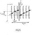
- the conditional neighborhood N ij, k (r) is chosen such that, for any local continuous seismic trace S pq, k (t) belonging to N ij, k (r), the optimal offset h ij, pq, k corresponding to such that the correlation R ij, pq, k (h ij, pq, k ) between S ij, k (t) and S pq, k (t) is greater than a predetermined threshold r between 0 and 1.
- the setting of the threshold r also makes it possible to encompass in a conditional neighborhood a discontinuity or a geological fault, which constitutes an important advantage over the prior art.
- a method according to the invention comprises a numerical modeling step 100 for defining continuous local seismic traces, optimal offsets and conditional neighborhoods, as described with reference to Figures 1 to 5 .
- step 101 a two-dimensional matrix is defined whose row and column indices correspond to the coordinates of the geophones of seismic measurements.
- step 102 a "seed" point P (i, j, t) or first extraction point is selected.
- step 103 the node (i, j, k) of the three-dimensional seismic matrix closest to the "seed" point P (i, j, t) is determined.
- step 104 the local continuous seismic traces S pq, k (t) belonging to the conditional neighborhood N ij, k (r) defined in step 100 and such as the indices (p, q) are first selected. ) correspond to an empty location of the bidimensional matrix defined in step 101.
- the point P (p, q, t) is assigned the value P (p, q, t + h ij, pq, k ), where h ij, pq, k is the optimal offset of the point P (p, q, t) with respect to the neighboring point P (i, j, k) determined in step 103.
- This point P (p, q, t + h ij, pq, k ) is considered a new point on the horizon and is stored in the location (p, q) of the two-dimensional matrix defined in step 101.
- the method just described is intended to determine a set of points belonging to the horizon passing through a point P (i, j, t), but is also applicable to attach to these points, as and when their determination, a set of properties characterizing the physical nature of the terrains in the vicinity of the horizon thus determined.
- These properties are usually represented by different colors on the screen visualizations, so as to allow quick and error-free visualization of the properties associated with a geological horizon.
- steps similar to the steps described with reference to steps 100 to 104 are performed and the attributes of the point P (p, q, t + h ij, pq, k ) are constructed using the equation the local continuous seismic trace S pq, k (t); for example, an envelope attribute, a phase attribute or a frequency attribute is thus constructed in a manner known per se, for example according to the teaching of the document TANER MT, KOEHLER F., SHERIFF RE, (1979), Seismic Trace Analysis Complex, GEOPHYSICS, Volume 44, No. 6, pp. 1041-1063. .
- This method makes it possible to display the seismic attribute on the extracted horizon by "painting" it with the corresponding colors.
- the method just described thus makes it possible to define extraction values of a predetermined horizon corresponding to an actual datum, but only in a conditional neighborhood of the point P (ij, k) closest to the "seed" point P. (i, j, t) chosen.
- a set of new seeds constituted by the new points P (p, q, t + h ij, pq) is first constructed.
- , k located on the horizon which have just been determined and is stored in the corresponding locations (p, q) of the two-dimensional matrix defined in step 101.
- Each of its points is stored in step 106, for to be reinjected at step 102, serving as a new point "seed".
- the method is oriented in step 106 to a step 107 of screen viewing horizons or attributes or properties associated with geological horizon, so as to allow visualization in color or in grayscale properties associated with the extracted geological horizon corresponding to the real time t.
- the two-dimensional matrix of step 101 contains a plurality of points corresponding to the same horizon as the initial point "seed" chooses P (i, j, t).
- the set of points can be reordered with its neighbors, in accordance with the figure 7 to define a mesh entirely covering the horizon containing the point "seed" P (i, j, t), this mesh thus makes it possible to represent the extracted horizon as a locally continuous surface on the display screen of a station of job.
- the method according to the invention is preferably implemented on a device comprising means suitable for implementing the steps described with reference to the figure 6 .
- a device comprises storage means required for the successive calculations and the display means necessary for step 107.
- a device according to the invention is a programmable device controlled by a computer program product comprising program code elements for carrying out the steps of the method described with reference to the figure 6 .
Landscapes
- Engineering & Computer Science (AREA)
- Remote Sensing (AREA)
- Physics & Mathematics (AREA)
- Life Sciences & Earth Sciences (AREA)
- Acoustics & Sound (AREA)
- Environmental & Geological Engineering (AREA)
- Geology (AREA)
- General Life Sciences & Earth Sciences (AREA)
- General Physics & Mathematics (AREA)
- Geophysics (AREA)
- Geophysics And Detection Of Objects (AREA)
Claims (9)
- Verfahren zum Extrahieren eines geologischen Horizonts und einer seismischen Darstellung zugeordneten Eigenschaften, bei dem eine kontinuierliche Funktion Sij,k(t) per Interpolation oder Näherung der diskreten seismischen Spuren einer dreidimensionalen seismischen Matrix aufgebaut wird, wobei die genannte Funktion als "kontinuierliche, lokale, seismische Spur" bezeichnet wird, umfassend die folgenden Schritte:a) Verwendung des Verschiebungswertes, der ihre Korrelationsfunktion maximal macht, als optimale (vertikale) Verschiebung von zwei benachbarten, kontinuierlichen, lokalen, seismischen Spuren, wobei diese optimale Verschiebung nicht zwingend ein ganzes Vielfaches der vertikalen Probennahme sein muss;b) Zurückhalten der Teil-Nachbarschaft, bestehend aus benachbarten Spuren Spq,k(t), die optimalen Verschiebungen hij,pq,k entsprechen, die Korrelationen Rij,pq,k(hij,pq,k) zugeordnet sind, die einen zwischen 0 und 1 inbegriffenen vorbestimmten Schwellenwert übersteigen, als bedingte Nachbarscheit einer "zentralen", kontinuierlichen, lokalen, seismischen Spur Sij,k(t);c) Aufbau einer zweidimensionalen Extraktionsmatrix durch Wahl eines "Korn"-Punktes P(i,j,t) per Bestimmung des Punktes P(i,j,k) der vertikal nächsten dreidimensionalen seismischen Matrix und durch Füllen der zweidimensionalen Extraktionsmatrix mit extrahierten Punkten, die zu demselben Horizont gehören wie dem, der an dem Kornpunkt derart vorbeiläuft, dass der Standort (p,q) der zweidimensionalen Matrix den Punkt P (p,q,t+hij,pq,k) speichert; undd) Schätzung der jedem Punkt der Extraktionsmatrix zugeordneten Eigenschaften anhand der Gleichung der lokalen, kontinuierlichen, seismischen Spur Spq,k(t).
- Verfahren gemäß Anspruch 1, bei dem als "Korn"-Punkt des Schritts c) alle neu in der zweidimensionalen Matrix gespeicherten und noch nicht als Kornpunkt verwendeten Punkt verwendet werden.
- Verfahren gemäß Anspruch 1 oder 2, bei dem sukzessive der Inhalt der zweidimensionalen Matrix des Schritts c) im Verlauf der sukzessiven Extraktionsiterationen befüllt wird.
- Verfahren gemäß Anspruch 1 oder 2, bei dem sukzessive der Inhalt der zweidimensionalen Matrix des Schritts c) durch einen Durchschnitt der sukzessiven Inhalte im Verlauf der sukzessiven Extraktionsiterationen ersetzt wird.
- Verfahren gemäß Anspruch 1 oder 2, bei dem die Eigenschaft der extrahierten Teiloberfläche eine Gruppe von seismischen Attributen ist, die in jedem extrahierten Punkt auf dem durch den Kornpunkt hindurchlaufenden Horizont berechnet sind, wobei die Berechnung dieser Attribute selbst gleichzeitig mit der Extraktion dieser Punkte realisiert ist.
- Verfahren gemäß Anspruch 1 oder Anspruch 5, bei dem auf einem Anzeigebildschirm die auf dem extrahierten Horizont "aufgemalten" seismischen Attribute angezeigt werden.
- Vorrichtung für die Umsetzung des Verfahrens gemäß irgendeinem der Ansprüche 1 bis 4, umfassend Mittel zur Verwendung des Verschiebungswertes, der ihre Korrelationsfunktion maximal macht, als optimale Verschiebung von zwei benachbarten, kontinuierlichen, lokalen, seismischen Spuren, Mittel zum Festhalten der Teil-Nachbarschaft, die aus benachbarten Spuren Spq,k(t) besteht, die optimalen Verschiebungen hij, pq k entsprechen, die einen zwischen 0 und 1 inbegriffenen vorbestimmten Schwellenwert übersteigenden Korrelationen Rij,pq,k(hij,pq,k) zugeordnet sind, als bedingte Nachbarschaft einer "zentralen", kontinuierlichen, lokalen, seismischen Referenzspur Sij,k(t), Mittel zum Aufbau einer zweidimensionalen Extraktionsmatrix durch die Wahl eines "Korn"-Punkts P(i,j,t), durch Bestimmung des Punktes P(i,j,k) der nächsten vertikal dreidimensionalen seismischen Matrix und durch Befüllen der zweidimensionalen Extraktionsmatrix mit extrahierten Punkten, die zu demselben Horizont gehören wie der, der durch den Kornpunkt derart hindurchläuft, dass der Standort (p,q) der zweidimensionalen Matrix den Punkt P(p,q,t+hij,pq,k) und die Mittel zum Schätzen der jedem Punkt der Extraktionsmatrix zugeordneten Eigenschaften anhand der Gleichung der lokalen, kontinuierlichen seismischen Spur Spq,k(t) speichert.
- Vorrichtung gemäß Anspruch 7, umfassend Speichermittel und Anzeigemittel von seismischen Parametern, die anhand des Verfahrens gemäß irgendeinem der Ansprüche 1 bis 16 bestimmt werden.
- Computerprogrammprodukt, umfassend Programmcodeelemente zur Ausführung der Schritte des Verfahrens gemäß irgendeinem der Ansprüche 1 bis 6, wenn das genannte Programm durch einen Computer ausgeführt wird.
Applications Claiming Priority (3)
| Application Number | Priority Date | Filing Date | Title |
|---|---|---|---|
| FR0207596 | 2002-06-19 | ||
| FR0207596A FR2841343B1 (fr) | 2002-06-19 | 2002-06-19 | Dispositif et produit-programme pour extraire un horizon geologique et des proprietes associees |
| PCT/FR2003/001753 WO2004001450A1 (fr) | 2002-06-19 | 2003-06-11 | Dispositif et produit-programme pour extraire un horizon geologique et des proprietes associees |
Publications (2)
| Publication Number | Publication Date |
|---|---|
| EP1514138A1 EP1514138A1 (de) | 2005-03-16 |
| EP1514138B1 true EP1514138B1 (de) | 2018-11-21 |
Family
ID=29719888
Family Applications (1)
| Application Number | Title | Priority Date | Filing Date |
|---|---|---|---|
| EP03760721.5A Expired - Lifetime EP1514138B1 (de) | 2002-06-19 | 2003-06-11 | Verfahren, system und computerprogrammprodukt zur auffindung eines geologischen horizontes und dessen eigenschaften |
Country Status (5)
| Country | Link |
|---|---|
| US (1) | US7328139B2 (de) |
| EP (1) | EP1514138B1 (de) |
| AU (1) | AU2003258795A1 (de) |
| FR (1) | FR2841343B1 (de) |
| WO (1) | WO2004001450A1 (de) |
Families Citing this family (9)
| Publication number | Priority date | Publication date | Assignee | Title |
|---|---|---|---|---|
| US8120991B2 (en) | 2006-11-03 | 2012-02-21 | Paradigm Geophysical (Luxembourg) S.A.R.L. | System and method for full azimuth angle domain imaging in reduced dimensional coordinate systems |
| US7986319B2 (en) * | 2007-08-01 | 2011-07-26 | Austin Gemodeling, Inc. | Method and system for dynamic, three-dimensional geological interpretation and modeling |
| FR2923312B1 (fr) * | 2007-11-06 | 2009-12-18 | Total Sa | Procede de traitement d'images sismiques du sous-sol |
| PL2359438T3 (pl) | 2008-11-20 | 2019-12-31 | Commscope Technologies Llc | Antena i szyk sektora dwuwiązkowego |
| CN103797382A (zh) | 2011-09-16 | 2014-05-14 | 兰德马克绘图国际公司 | 地下层位分配的方法和系统 |
| US9759826B2 (en) | 2012-04-03 | 2017-09-12 | Paradigm Sciences Ltd. | System and method for generating an implicit model of geological horizons |
| CN104614761B (zh) * | 2013-11-04 | 2017-07-07 | 中国石油天然气集团公司 | 一种双层洪水填充地震层位空间自动追踪方法及装置 |
| US11609355B2 (en) | 2018-10-02 | 2023-03-21 | Chevron U.S.A. Inc. | System and method for generating an earth model |
| CN119535592B (zh) * | 2024-12-19 | 2025-10-10 | 中国海洋石油集团有限公司 | 一种二维偏移地震剖面生成方法、装置、设备及介质 |
Family Cites Families (10)
| Publication number | Priority date | Publication date | Assignee | Title |
|---|---|---|---|---|
| US3731269A (en) * | 1971-04-05 | 1973-05-01 | Chevron Res | Static corrections for seismic traces by cross-correlation method |
| US4672546A (en) * | 1984-11-08 | 1987-06-09 | Texas Instruments Incorporated | Systems for extracting horizons contained in a 3-D network of turnings and converting the horizons to a 2-D format |
| US5251184A (en) * | 1991-07-09 | 1993-10-05 | Landmark Graphics Corporation | Method and apparatus for finding horizons in 3D seismic data |
| US5930730A (en) * | 1994-12-12 | 1999-07-27 | Amoco Corporation | Method and apparatus for seismic signal processing and exploration |
| US6014343A (en) * | 1996-10-31 | 2000-01-11 | Geoquest | Automatic non-artificially extended fault surface based horizon modeling system |
| US6138075A (en) * | 1998-08-05 | 2000-10-24 | Landmark Graphics Corporation | Methods and apparatus for analyzing seismic data |
| US6151555A (en) * | 1999-03-09 | 2000-11-21 | Schlumberger Technology Corporation | Seismic signal processing method and apparatus for generating a cube of variance values |
| EP1746443B1 (de) * | 1999-10-22 | 2014-01-08 | Fugro N.V. | Verfahren zur Kalkulation elastischer Parameter und Gesteinszusammensetzungen von unterirdischen Formationen unter Verwendung seismischer Daten |
| MY125603A (en) * | 2000-02-25 | 2006-08-30 | Shell Int Research | Processing seismic data |
| US6950751B2 (en) * | 2003-03-31 | 2005-09-27 | Conocophillps Company | Method and apparatus for the assimilation and visualization of information from 3D data volumes |
-
2002
- 2002-06-19 FR FR0207596A patent/FR2841343B1/fr not_active Expired - Lifetime
-
2003
- 2003-06-11 US US10/518,484 patent/US7328139B2/en not_active Expired - Lifetime
- 2003-06-11 AU AU2003258795A patent/AU2003258795A1/en not_active Abandoned
- 2003-06-11 EP EP03760721.5A patent/EP1514138B1/de not_active Expired - Lifetime
- 2003-06-11 WO PCT/FR2003/001753 patent/WO2004001450A1/fr not_active Ceased
Non-Patent Citations (1)
| Title |
|---|
| None * |
Also Published As
| Publication number | Publication date |
|---|---|
| US20060129359A1 (en) | 2006-06-15 |
| WO2004001450A1 (fr) | 2003-12-31 |
| FR2841343B1 (fr) | 2005-05-27 |
| AU2003258795A1 (en) | 2004-01-06 |
| US7328139B2 (en) | 2008-02-05 |
| FR2841343A1 (fr) | 2003-12-26 |
| EP1514138A1 (de) | 2005-03-16 |
Similar Documents
| Publication | Publication Date | Title |
|---|---|---|
| EP1514139B1 (de) | Verfahren, einrichtung und softwarepaket zur glättung einer unteroberflächeneigenschaft | |
| EP1464032B1 (de) | Verfahren, einrichtung und programm zur dreidimensionalen modellierung eines geologischen volumens durch 3d-parametrisierung des geologischen bereichs | |
| US9720119B2 (en) | Seismic image filtering machine to generate a filtered seismic image, program products, and related methods | |
| EP1257850B1 (de) | Verarbeitung von seismischen daten | |
| EP1394569B1 (de) | Verfahren zur Berechnung von Maschenmodellen eines Reservoirs | |
| FR2909185A1 (fr) | Methode d'interpretation stratigraphique d'images sismiques | |
| EP3023815A1 (de) | Konstruktionsverfahren eines geologischen modells | |
| EP1926033A1 (de) | Verfahren, Programm und Informatiksystem zur Fahrrinnen-Simulierung | |
| FR2747477A1 (fr) | Methode d'inversion pour donnees sismiques | |
| EP1514138A1 (de) | Einrichtung und softwarepaket zum extrahieren eines geologischen horizonts und diesbezüglicher eigenschaften | |
| FR2885227A1 (fr) | Methode d'interpretation sedimentologique par estimation de differents scenarios chronologiques de mise en place des couches sedimentaires | |
| EP2992361B1 (de) | Vorrichtung und verfahren zur optimierung seismischer 4d- und 3d-daten | |
| FR2758397A1 (fr) | Procede et appareil pour determiner des relations geologiques entre des failles s'entrecroisant | |
| EP2873989B1 (de) | Verfahren zum Erstellen eines repräsentativen Rasters einer physikalischen Eigentumsstreuung einer unterirdischen Formation durch bedingte statistische Mehrpunktsimulation | |
| EP3140677B1 (de) | Verfahren zur verarbeitung von seismischen bildern | |
| WO2009090522A1 (fr) | Procede, programme et systeme informatique de construction d'un modele geologique 3d | |
| Fitzgerald et al. | A case study on geophysical gridding techniques: INTREPID perspective | |
| EP1514137B1 (de) | Verfahren, einrichtung und softwarepaket zur lokalen bestimmung der form geologischer horizonte | |
| CA2452206C (fr) | Perfectionnements aux techniques de pointe de surface | |
| Liu et al. | CycleGAN integration of high-resolution crooked lines into 3D seismic volumes: Enhancing data set resolution on the Loess Plateau, China | |
| EP0426515B1 (de) | Massnahmen zur Verbesserung von seismischen Prospektionsverfahren | |
| FR2888645A1 (fr) | Procede d'acquisition et de traitement de donnees magnetometriques par des mises a jour locales et en temps reel | |
| US7450468B2 (en) | Methods, systems, and computer readable media for interactively determining parameters for ocean-bottom hydrophone/geophone receiver combination deghosting | |
| AU2001256165A1 (en) | Processing seismic data |
Legal Events
| Date | Code | Title | Description |
|---|---|---|---|
| PUAI | Public reference made under article 153(3) epc to a published international application that has entered the european phase |
Free format text: ORIGINAL CODE: 0009012 |
|
| 17P | Request for examination filed |
Effective date: 20041213 |
|
| AK | Designated contracting states |
Kind code of ref document: A1 Designated state(s): AT BE BG CH CY CZ DE DK EE ES FI FR GB GR HU IE IT LI LU MC NL PT RO SE SI SK TR |
|
| AX | Request for extension of the european patent |
Extension state: AL LT LV MK |
|
| DAX | Request for extension of the european patent (deleted) | ||
| 17Q | First examination report despatched |
Effective date: 20061106 |
|
| RIN1 | Information on inventor provided before grant (corrected) |
Inventor name: DULAC, JEAN-CLAUDE Inventor name: BOSQUET, FABIEN Inventor name: LABRUNYE, EMMANUEL |
|
| RAP1 | Party data changed (applicant data changed or rights of an application transferred) |
Owner name: PARADIGM FRANCE |
|
| STAA | Information on the status of an ep patent application or granted ep patent |
Free format text: STATUS: EXAMINATION IS IN PROGRESS |
|
| RIC1 | Information provided on ipc code assigned before grant |
Ipc: G01V 1/30 19680901AFI20180517BHEP |
|
| GRAP | Despatch of communication of intention to grant a patent |
Free format text: ORIGINAL CODE: EPIDOSNIGR1 |
|
| STAA | Information on the status of an ep patent application or granted ep patent |
Free format text: STATUS: GRANT OF PATENT IS INTENDED |
|
| INTG | Intention to grant announced |
Effective date: 20180706 |
|
| GRAS | Grant fee paid |
Free format text: ORIGINAL CODE: EPIDOSNIGR3 |
|
| GRAA | (expected) grant |
Free format text: ORIGINAL CODE: 0009210 |
|
| STAA | Information on the status of an ep patent application or granted ep patent |
Free format text: STATUS: THE PATENT HAS BEEN GRANTED |
|
| AK | Designated contracting states |
Kind code of ref document: B1 Designated state(s): AT BE BG CH CY CZ DE DK EE ES FI FR GB GR HU IE IT LI LU MC NL PT RO SE SI SK TR |
|
| REG | Reference to a national code |
Ref country code: GB Ref legal event code: FG4D Free format text: NOT ENGLISH |
|
| REG | Reference to a national code |
Ref country code: CH Ref legal event code: EP |
|
| REG | Reference to a national code |
Ref country code: IE Ref legal event code: FG4D Free format text: LANGUAGE OF EP DOCUMENT: FRENCH |
|
| REG | Reference to a national code |
Ref country code: AT Ref legal event code: REF Ref document number: 1068206 Country of ref document: AT Kind code of ref document: T Effective date: 20181215 |
|
| REG | Reference to a national code |
Ref country code: DE Ref legal event code: R096 Ref document number: 60351647 Country of ref document: DE |
|
| REG | Reference to a national code |
Ref country code: CH Ref legal event code: PK Free format text: RECTIFICATIONS |
|
| RIC2 | Information provided on ipc code assigned after grant |
Ipc: G01V 1/30 20060101AFI20180517BHEP |
|
| REG | Reference to a national code |
Ref country code: NL Ref legal event code: MP Effective date: 20181121 |
|
| REG | Reference to a national code |
Ref country code: AT Ref legal event code: MK05 Ref document number: 1068206 Country of ref document: AT Kind code of ref document: T Effective date: 20181121 |
|
| PG25 | Lapsed in a contracting state [announced via postgrant information from national office to epo] |
Ref country code: AT Free format text: LAPSE BECAUSE OF FAILURE TO SUBMIT A TRANSLATION OF THE DESCRIPTION OR TO PAY THE FEE WITHIN THE PRESCRIBED TIME-LIMIT Effective date: 20181121 Ref country code: ES Free format text: LAPSE BECAUSE OF FAILURE TO SUBMIT A TRANSLATION OF THE DESCRIPTION OR TO PAY THE FEE WITHIN THE PRESCRIBED TIME-LIMIT Effective date: 20181121 Ref country code: BG Free format text: LAPSE BECAUSE OF FAILURE TO SUBMIT A TRANSLATION OF THE DESCRIPTION OR TO PAY THE FEE WITHIN THE PRESCRIBED TIME-LIMIT Effective date: 20190221 Ref country code: FI Free format text: LAPSE BECAUSE OF FAILURE TO SUBMIT A TRANSLATION OF THE DESCRIPTION OR TO PAY THE FEE WITHIN THE PRESCRIBED TIME-LIMIT Effective date: 20181121 |
|
| PG25 | Lapsed in a contracting state [announced via postgrant information from national office to epo] |
Ref country code: NL Free format text: LAPSE BECAUSE OF FAILURE TO SUBMIT A TRANSLATION OF THE DESCRIPTION OR TO PAY THE FEE WITHIN THE PRESCRIBED TIME-LIMIT Effective date: 20181121 Ref country code: SE Free format text: LAPSE BECAUSE OF FAILURE TO SUBMIT A TRANSLATION OF THE DESCRIPTION OR TO PAY THE FEE WITHIN THE PRESCRIBED TIME-LIMIT Effective date: 20181121 Ref country code: GR Free format text: LAPSE BECAUSE OF FAILURE TO SUBMIT A TRANSLATION OF THE DESCRIPTION OR TO PAY THE FEE WITHIN THE PRESCRIBED TIME-LIMIT Effective date: 20190222 Ref country code: PT Free format text: LAPSE BECAUSE OF FAILURE TO SUBMIT A TRANSLATION OF THE DESCRIPTION OR TO PAY THE FEE WITHIN THE PRESCRIBED TIME-LIMIT Effective date: 20190321 |
|
| PG25 | Lapsed in a contracting state [announced via postgrant information from national office to epo] |
Ref country code: DK Free format text: LAPSE BECAUSE OF FAILURE TO SUBMIT A TRANSLATION OF THE DESCRIPTION OR TO PAY THE FEE WITHIN THE PRESCRIBED TIME-LIMIT Effective date: 20181121 Ref country code: IT Free format text: LAPSE BECAUSE OF FAILURE TO SUBMIT A TRANSLATION OF THE DESCRIPTION OR TO PAY THE FEE WITHIN THE PRESCRIBED TIME-LIMIT Effective date: 20181121 Ref country code: CZ Free format text: LAPSE BECAUSE OF FAILURE TO SUBMIT A TRANSLATION OF THE DESCRIPTION OR TO PAY THE FEE WITHIN THE PRESCRIBED TIME-LIMIT Effective date: 20181121 |
|
| REG | Reference to a national code |
Ref country code: DE Ref legal event code: R097 Ref document number: 60351647 Country of ref document: DE |
|
| PG25 | Lapsed in a contracting state [announced via postgrant information from national office to epo] |
Ref country code: SK Free format text: LAPSE BECAUSE OF FAILURE TO SUBMIT A TRANSLATION OF THE DESCRIPTION OR TO PAY THE FEE WITHIN THE PRESCRIBED TIME-LIMIT Effective date: 20181121 Ref country code: RO Free format text: LAPSE BECAUSE OF FAILURE TO SUBMIT A TRANSLATION OF THE DESCRIPTION OR TO PAY THE FEE WITHIN THE PRESCRIBED TIME-LIMIT Effective date: 20181121 Ref country code: EE Free format text: LAPSE BECAUSE OF FAILURE TO SUBMIT A TRANSLATION OF THE DESCRIPTION OR TO PAY THE FEE WITHIN THE PRESCRIBED TIME-LIMIT Effective date: 20181121 |
|
| PLBE | No opposition filed within time limit |
Free format text: ORIGINAL CODE: 0009261 |
|
| STAA | Information on the status of an ep patent application or granted ep patent |
Free format text: STATUS: NO OPPOSITION FILED WITHIN TIME LIMIT |
|
| 26N | No opposition filed |
Effective date: 20190822 |
|
| PG25 | Lapsed in a contracting state [announced via postgrant information from national office to epo] |
Ref country code: SI Free format text: LAPSE BECAUSE OF FAILURE TO SUBMIT A TRANSLATION OF THE DESCRIPTION OR TO PAY THE FEE WITHIN THE PRESCRIBED TIME-LIMIT Effective date: 20181121 |
|
| REG | Reference to a national code |
Ref country code: DE Ref legal event code: R119 Ref document number: 60351647 Country of ref document: DE |
|
| PG25 | Lapsed in a contracting state [announced via postgrant information from national office to epo] |
Ref country code: MC Free format text: LAPSE BECAUSE OF FAILURE TO SUBMIT A TRANSLATION OF THE DESCRIPTION OR TO PAY THE FEE WITHIN THE PRESCRIBED TIME-LIMIT Effective date: 20181121 |
|
| REG | Reference to a national code |
Ref country code: CH Ref legal event code: PL |
|
| REG | Reference to a national code |
Ref country code: BE Ref legal event code: MM Effective date: 20190630 |
|
| PG25 | Lapsed in a contracting state [announced via postgrant information from national office to epo] |
Ref country code: TR Free format text: LAPSE BECAUSE OF FAILURE TO SUBMIT A TRANSLATION OF THE DESCRIPTION OR TO PAY THE FEE WITHIN THE PRESCRIBED TIME-LIMIT Effective date: 20181121 |
|
| PG25 | Lapsed in a contracting state [announced via postgrant information from national office to epo] |
Ref country code: IE Free format text: LAPSE BECAUSE OF NON-PAYMENT OF DUE FEES Effective date: 20190611 Ref country code: DE Free format text: LAPSE BECAUSE OF NON-PAYMENT OF DUE FEES Effective date: 20200101 |
|
| PG25 | Lapsed in a contracting state [announced via postgrant information from national office to epo] |
Ref country code: CH Free format text: LAPSE BECAUSE OF NON-PAYMENT OF DUE FEES Effective date: 20190630 Ref country code: LU Free format text: LAPSE BECAUSE OF NON-PAYMENT OF DUE FEES Effective date: 20190611 Ref country code: BE Free format text: LAPSE BECAUSE OF NON-PAYMENT OF DUE FEES Effective date: 20190630 Ref country code: LI Free format text: LAPSE BECAUSE OF NON-PAYMENT OF DUE FEES Effective date: 20190630 |
|
| PG25 | Lapsed in a contracting state [announced via postgrant information from national office to epo] |
Ref country code: CY Free format text: LAPSE BECAUSE OF FAILURE TO SUBMIT A TRANSLATION OF THE DESCRIPTION OR TO PAY THE FEE WITHIN THE PRESCRIBED TIME-LIMIT Effective date: 20181121 |
|
| PG25 | Lapsed in a contracting state [announced via postgrant information from national office to epo] |
Ref country code: HU Free format text: LAPSE BECAUSE OF FAILURE TO SUBMIT A TRANSLATION OF THE DESCRIPTION OR TO PAY THE FEE WITHIN THE PRESCRIBED TIME-LIMIT; INVALID AB INITIO Effective date: 20030611 |
|
| PGFP | Annual fee paid to national office [announced via postgrant information from national office to epo] |
Ref country code: GB Payment date: 20220519 Year of fee payment: 20 Ref country code: FR Payment date: 20220519 Year of fee payment: 20 |
|
| REG | Reference to a national code |
Ref country code: GB Ref legal event code: PE20 Expiry date: 20230610 |
|
| P01 | Opt-out of the competence of the unified patent court (upc) registered |
Effective date: 20230528 |
|
| PG25 | Lapsed in a contracting state [announced via postgrant information from national office to epo] |
Ref country code: GB Free format text: LAPSE BECAUSE OF EXPIRATION OF PROTECTION Effective date: 20230610 |