EP1514137B1 - Verfahren, einrichtung und softwarepaket zur lokalen bestimmung der form geologischer horizonte - Google Patents
Verfahren, einrichtung und softwarepaket zur lokalen bestimmung der form geologischer horizonte Download PDFInfo
- Publication number
- EP1514137B1 EP1514137B1 EP03760722A EP03760722A EP1514137B1 EP 1514137 B1 EP1514137 B1 EP 1514137B1 EP 03760722 A EP03760722 A EP 03760722A EP 03760722 A EP03760722 A EP 03760722A EP 1514137 B1 EP1514137 B1 EP 1514137B1
- Authority
- EP
- European Patent Office
- Prior art keywords
- continuous local
- neighbourhood
- conditional
- seismic
- local seismic
- Prior art date
- Legal status (The legal status is an assumption and is not a legal conclusion. Google has not performed a legal analysis and makes no representation as to the accuracy of the status listed.)
- Expired - Lifetime
Links
Images

Classifications
-
- G—PHYSICS
- G01—MEASURING; TESTING
- G01V—GEOPHYSICS; GRAVITATIONAL MEASUREMENTS; DETECTING MASSES OR OBJECTS; TAGS
- G01V1/00—Seismology; Seismic or acoustic prospecting or detecting
- G01V1/28—Processing seismic data, e.g. for interpretation or for event detection
- G01V1/30—Analysis
- G01V1/301—Analysis for determining seismic cross-sections or geostructures
Definitions
- the invention relates to a method for locally determining the shape of geological horizons from the data obtained by processing seismic measurements.
- the invention also relates to a device for locally determining the shape of the geological horizons from data obtained by processing seismic measurements.
- the invention relates to a computer program product allowing the operation of a programmable device according to the invention, for the implementation of a method according to the invention.
- the document US 6,151,555 relates to a seismic signal processing method and a device for determining a variance value cube.
- This method provides for calculating for each node of a three-dimensional seismic matrix a variance value equal to the variance of the seismic amplitudes in the vicinity of the considered node.
- the neighborhood of the considered node is a subset of the nodes of the three-dimensional matrix whose distance to the considered node is less than a chosen threshold. This method is based on the assumption that the value of variance thus defined is important for the nodes close to a discontinuity.
- the document WO 99/64896 describes a seismic data interpretation method, particularly suitable for identifying hydrocarbon reservoir boundaries.
- a first object of the invention is to improve the analyzes of the profile of geometric horizons.
- a second object of the invention is to facilitate the determination of normal unit vectors to the horizons of a three-dimensional seismic cube.
- a third object of the invention is to facilitate the determination of a curvature index of the horizons in a three-dimensional seismic cube.
- the invention also relates to a device according to claim 7, for implementing the method according to the invention, comprising means for using as an optimal offset two adjacent continuous local seismic traces the offset value maximizing their function of correlation means for retaining as a conditional neighborhood a "central" continuous local seismic trace S ij, k (t) the sub-neighborhood consisting of neighboring traces S pq, k (t) corresponding to optimal offsets associated with correlations R ij, p, k (h) greater than an edéterminé threshold between 0 and 1, characterized in that the device further comprises continuous local seismic means S pq, k (t) of the conditional neighborhood a residual value by relative to said "central" continuous local seismic trace S ij, k (t) having parametric coefficients and means for determining the parametric coefficients by overall minimization residues on the conditional neighborhood.
- the invention finally relates to a computer program product according to claim 9, comprising program code elements for executing the steps of a method according to the invention, when said program is executed by a computer.
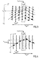
- a three-dimensional seismic matrix is obtained by reading measurements recorded by geophones G ij arranged on a network x, y at points of coordinates i, j.
- the measurement of the measurements sampled over time is represented along a downward t-axis representative of the depth or of a descending vertical from the surface of the earth or the sea.
- the measurements are characterized by their amplitude, for example an amplitude taken by the geophone G ij at the time or at the sampling depth t k .
- the discrete measurement made by the geophone G ij at the time or the depth t k is called the seismic amplitude S ij, k .
- the set of seismic amplitudes corresponding to a geophone G ij of coordinates i, j is a one-dimensional matrix (S ij1 , S ij2 , ...., S ijk , ...., S ijN ) called discrete seismic trace, because this one-dimensional matrix corresponds to the trace according to the point of horizontal coordinates i, j of the three-dimensional seismic matrix obtained by seismic measurements.
- the vertical axis t in a descending vertical direction usually refers to time, but can also be processed to represent a depth from the surface.
- the invention relates both to the application to a third coordinate representative t of time, and to a third coordinate t representative of the depth.
- continuous local seismic traces define an example of neighborhood of a continuous local seismic trace "central" S ij, k (t) of reference.
- the neighborhood of a continuous local seismic trace S ij, k (t) is defined as the set of continuous local seismic traces whose horizontal spatial indices p, q are adjacent to the horizontal spatial indices i, j of the continuous local seismic trace reference.
- the horizontal spatial coordinates p, q corresponding to the geophone Gpq are close to the horizontal spatial coordinates i, j corresponding to the geophone G ij if the absolute values of the differences ip and jq are smaller than given integers, for example to 2.
- the local continuous seismic trace S ij, k (t) is associated with eight adjacent continuous local seismic traces surrounding the "central" continuous local seismic trace S ij, k (t).
- the numerator corresponds to the covariance function of S ij, k (t)
- the conditional neighborhood N ij, k (r) is chosen such that, for any local continuous seismic trace S pq, k (t) belonging to N ij, k (r), the optimal offset h ij, pq, k corresponding to such that the correlation R ij, pq, k (h ij, pq, k ) between S ij, k (t) and S pq, k (t) is greater than a predetermined threshold r between 0 and 1.
- the setting of the threshold r also makes it possible to encompass in a conditional neighborhood a discontinuity or a geological fault, which constitutes an important advantage over the prior art.
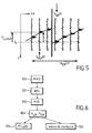
- step 100 the numerical modeling described with reference to Figures 1 to 5 is performed in step 100 to implement a method according to the invention.
- step 101 for each continuous local seismic trace S pq, k (t) of the conditional neighborhood N ij, k (r) a residual value with respect to said local seismic trace continuous S ij, k (t) reference center comprising parametric coefficients.
- the residual value ⁇ ij, pq, k chosen reflects the difference between the horizon at the vertical of the geophone Gpq and the plane tangent to the horizon at the vertical of the geophone G ij .
- the parameters a ij, k and b ij, k which correspond to an overall minimization of the residues ⁇ ij, pq, k on the conditional neighborhood at step 102.
- each term ( ⁇ ij, pq, k ) ⁇ of this sum can be weighted by an increasing function factor of the correlation coefficient P ij, pq, k (h ij, pq, k ).
- step 102 produces as a result in step 103 the best estimate of the coefficients a ij, k and b ij, k which are the directional coefficients of the horizon passing through the point of horizontal coordinates i, j and temporal coordinate or depth k.
- the normal unit vector thus obtained or any vector which is parallel thereto allows a screen display more efficient than the visualizations of the prior art, so as to reveal the seismic parameters and the profiles of the geological horizons with an improved contrast compared to the prior art.
- the curvature index of the horizon at the point of spatial coordinates i, j and of the temporal or depth coordinate k is chosen to be an increasing function of the residuals comprising the coefficients a ij. , k and b ij, k determined in step 103.
- the criterion of minimization can be used as an indicator or curvature index.
- VS ⁇ i ⁇ j ⁇ k ⁇ p , q ( ⁇ ij , pk , k ⁇ ) ⁇ used to calculate the parametric coefficients a ij, k and b ij, k determined in step 103.
- any increasing function of the residues will be equal to zero and the local curvature index will be therefore also equal to zero.
- the curvature index calculated at step 105 of the method according to the invention provides an indication or a measure of the difference between the horizon considered and the locally osculating plane at the point of spatial coordinates i, j and time coordinate or depth k.
- the invention also makes it possible, by calculating the curvature index and its graphic representation on a screen, to improve the contrast of the seismic measurements provided by the geophones in the form of a three-dimensional seismic matrix and thus to avoid additional seismic measurements judged on the screen. neighborhood of discontinuities or geological faults.
- the preferred implementation of a method according to the invention consists in using a device for implementing the method containing a computer program product executing the steps of the method according to the invention described with reference to the Figures 1 to 6 .
- the device according to the invention is provided with appropriate storage means for memorizing and calculating the elements successively used in the method according to the invention.
- the implementation of the method according to the invention is carried out on a seismic computation workstation by loading a program product according to the invention comprising program code elements to execute the steps of the method according to the invention. invention.
- the program product may include program code elements relating to steps 100, 101, 102, 103 and 104 described with reference to the figure 6 .
- the program product according to the invention can comprise the program code elements for executing the steps 100, 101, 102, 103 and 105 described with reference to FIG. figure 6 .
- a computer program product according to the invention may also comprise program code elements for executing at least all of the method steps described with reference to FIG. figure 6 .
Landscapes
- Engineering & Computer Science (AREA)
- Remote Sensing (AREA)
- Physics & Mathematics (AREA)
- Life Sciences & Earth Sciences (AREA)
- Geology (AREA)
- Environmental & Geological Engineering (AREA)
- Acoustics & Sound (AREA)
- General Life Sciences & Earth Sciences (AREA)
- General Physics & Mathematics (AREA)
- Geophysics (AREA)
- Geophysics And Detection Of Objects (AREA)
- Management, Administration, Business Operations System, And Electronic Commerce (AREA)
- Measuring And Recording Apparatus For Diagnosis (AREA)
- Testing Or Measuring Of Semiconductors Or The Like (AREA)
- Containers And Plastic Fillers For Packaging (AREA)
Claims (9)
- Verfahren zur lokalen Bestimmung der Form geologischer Horizonte, bei dem man eine zusammenhängende Funktion Sij,k(t) durch Interpolation oder Näherung der diskreten seismischen Spuren einer dreidimensionalen seismischen Matrix konstruiert, wobei die Funktion Sij.k(t) als "zusammenhangende lokale seismische Spur" bezeichnet wird und das Verfahren folgende Schritte umfaßt:a) Einsetzen des Verschiebungswertes, der die Korrelationsfunktion zweier benachbarter, zusammenhängender lokaler seismischer Spuren maximal werden läßt, als optimale Verschiebung der zwei benachbarten, zusammenhängenden lokalen seismischen Spuren, wobei diese optimale Verschiebung nicht auf ein ganzzahliges Vielfaches des vertikalen Tastabstandes beschränkt ist;b) Verwenden der Teilumgebung, die aus benachbarten Spuren Spq,k(t) besteht, welche optimalen Verschiebungen hij,pq,k entsprechen, denen Korrelationen Rij,pq,k(hij,pq,k) zugeordnet sind, welche größer als ein vorbestimmter Schwellwert im Bereich von 0 bis 1 sind, als eingeschränkte Umgebung einer "zentralen" zusammenhängenden lokalen seismischen Spur Sij,k(t);
dadurch gekennzeichnet, daß das Verfahren ferner die folgenden Schritte umfaßt:c) Festlegen eines Restwertes für jede zusammenhängende lokale seismische Spur Spq,k(t) der eingeschränkten Umgebung relativ zur "zentralen" zusammenhängenden lokalen seismischen Spur Sij,k(t), der parametrische Koeffizienten umfaßt;d) Bestimmen der parametrischen Koeffizienten aij,k und bij,k durch Minimierung der Gruppe der Reste für die eingeschränkte Umgebung. - Verfahren nach Anspruch 1, bei dem die Restwerte aus dem Schritt c) absolute Werte in differentieller parametrischer Form sind, z. B. |aij,k•(p-1) + bij,k•(q-j) - hij,k|, worin aij,k und bij,k die Parameter sind und hij,pq,k die erhaltene optimale Verschiebung zwischen der "zentralen" zusammenhängenden lokalen seismischen Spur Sij,k(t) und einer benachbarten zusammenhängenden lokalen seismischen Spur Spq,k(t) ist.
- Verfahren nach Anspruch 1 oder Anspruch 2, bei dem die Minimierung der Gruppe der Reste ρij,pq,k in der eingeschränkten Umgebung eine Minimierung einer Summe von Potenzen der Reste mit der Formel

- Verfahren nach Anspruch 1, bei dem die im Schritt b) ermittelten Koeffizienten aij,k und bij,k dazu verwendet werden, einen Einheitsvektor N(i,j,k) mit den Koordinaten Nx(i,j,k), Ny(i,j,k), Nt(i,j,k), beispielsweise der Form


festzulegen, und bei dem man diesen Einheitsvektor als zum Horizont des Knotens (i, j, k) normalen (orthogonalen) Einheitsvektor wählt. - Verfahren nach Anspruch 4, bei dem man die Gruppe der Normal-Einheitsvektoren N(i, j, k) verwendet, um das Normal-Einheitsvektoren-Feld im Hinblick auf die Bildschirmanzeige der Profile der seismischen Horizonte festzulegen.
- Verfahren nach einem der Ansprüche 1 bis 3, bei dem man als Krümmungsindex eine steigende Funktion der Reste wählt, welche die im Schritt d) ermittelten parametrischen Koeffizienten umfassen.
- Vorrichtung zur Durchführung des Verfahrens nach einem der Ansprüche 1 bis 4, mit Mitteln, um als optimale Verschiebung zweier benachbarter zusammenhängender lokaler seismischer Spuren den Verschiebungswert einzusetzen, der deren Korrelationsfunktion maximal werden läßt, Mitteln, um die Teilumgebung, die aus benachbarten Spuren Spq,k(t) besteht, welche optimalen Verschiebungen entsprechen, denen Korrelationen Rij,pq,k(h) zugeordnet sind, welche größer als ein vorbestimmter Schwellwert im Bereich von 0 bis 1 sind, als eingeschränkte Umgebung einer "zentralen" zusammenhängenden lokalen seismischen Spur Sij,k(t) zu verwenden, dadurch gekennzeichnet, daß die Vorrichtung ferner umfaßt: Mittel zum Festlegen eines Restwertes für jede zusammenhängende lokale seismische Spur Spq,k(t) der eingeschränkten Umgebung relativ zur "zentralen" zusammenhängenden lokalen seismischen Spur Sij,k(t), der parametrische Koeffizienten umfaßt, und Mittel zum Bestimmen der parametrischen Koeffizienten durch Minimierung der Gruppe der Reste für die eingeschränkte Umgebung,
- Vorrichtung nach Anspruch 7, mit Mitteln zur Speicherung und Mitteln zur Anzeige von seismischen Parametern, die mit Hilfe des Verfahrens nach einem der Ansprüche 1 bis 6 ermittelt wurden.
- Computerprogrammprodukt mit Programmcode-Elementen zum Ausführen der Schritte des Verfahrens nach einem der Ansprüche 1 bis 6 bei der Ausführung des Programms auf einem Computer.
Applications Claiming Priority (3)
| Application Number | Priority Date | Filing Date | Title |
|---|---|---|---|
| FR0207598 | 2002-06-19 | ||
| FR0207598A FR2841345B1 (fr) | 2002-06-19 | 2002-06-19 | Procede, dispositif et produit-programme pour determiner localement le profil des horizons geologiques |
| PCT/FR2003/001754 WO2004001449A1 (fr) | 2002-06-19 | 2003-06-11 | Procede, dispositif et produit-programme pour determiner localement la forme des horizons geologiques |
Publications (2)
| Publication Number | Publication Date |
|---|---|
| EP1514137A1 EP1514137A1 (de) | 2005-03-16 |
| EP1514137B1 true EP1514137B1 (de) | 2008-03-26 |
Family
ID=29719890
Family Applications (1)
| Application Number | Title | Priority Date | Filing Date |
|---|---|---|---|
| EP03760722A Expired - Lifetime EP1514137B1 (de) | 2002-06-19 | 2003-06-11 | Verfahren, einrichtung und softwarepaket zur lokalen bestimmung der form geologischer horizonte |
Country Status (7)
| Country | Link |
|---|---|
| US (1) | US7295929B2 (de) |
| EP (1) | EP1514137B1 (de) |
| AT (1) | ATE390640T1 (de) |
| AU (1) | AU2003258796A1 (de) |
| DE (1) | DE60319984D1 (de) |
| FR (1) | FR2841345B1 (de) |
| WO (1) | WO2004001449A1 (de) |
Families Citing this family (1)
| Publication number | Priority date | Publication date | Assignee | Title |
|---|---|---|---|---|
| US11609355B2 (en) | 2018-10-02 | 2023-03-21 | Chevron U.S.A. Inc. | System and method for generating an earth model |
Family Cites Families (8)
| Publication number | Priority date | Publication date | Assignee | Title |
|---|---|---|---|---|
| US4672546A (en) * | 1984-11-08 | 1987-06-09 | Texas Instruments Incorporated | Systems for extracting horizons contained in a 3-D network of turnings and converting the horizons to a 2-D format |
| US5251184A (en) * | 1991-07-09 | 1993-10-05 | Landmark Graphics Corporation | Method and apparatus for finding horizons in 3D seismic data |
| US5930730A (en) * | 1994-12-12 | 1999-07-27 | Amoco Corporation | Method and apparatus for seismic signal processing and exploration |
| US6014343A (en) * | 1996-10-31 | 2000-01-11 | Geoquest | Automatic non-artificially extended fault surface based horizon modeling system |
| US5848379A (en) * | 1997-07-11 | 1998-12-08 | Exxon Production Research Company | Method for characterizing subsurface petrophysical properties using linear shape attributes |
| US6151555A (en) * | 1999-03-09 | 2000-11-21 | Schlumberger Technology Corporation | Seismic signal processing method and apparatus for generating a cube of variance values |
| EP1746443B1 (de) * | 1999-10-22 | 2014-01-08 | Fugro N.V. | Verfahren zur Kalkulation elastischer Parameter und Gesteinszusammensetzungen von unterirdischen Formationen unter Verwendung seismischer Daten |
| MY125603A (en) * | 2000-02-25 | 2006-08-30 | Shell Int Research | Processing seismic data |
-
2002
- 2002-06-19 FR FR0207598A patent/FR2841345B1/fr not_active Expired - Fee Related
-
2003
- 2003-06-11 AT AT03760722T patent/ATE390640T1/de not_active IP Right Cessation
- 2003-06-11 AU AU2003258796A patent/AU2003258796A1/en not_active Abandoned
- 2003-06-11 EP EP03760722A patent/EP1514137B1/de not_active Expired - Lifetime
- 2003-06-11 WO PCT/FR2003/001754 patent/WO2004001449A1/fr not_active Ceased
- 2003-06-11 DE DE60319984T patent/DE60319984D1/de not_active Expired - Lifetime
- 2003-06-11 US US10/518,632 patent/US7295929B2/en not_active Expired - Lifetime
Also Published As
| Publication number | Publication date |
|---|---|
| WO2004001449A1 (fr) | 2003-12-31 |
| DE60319984D1 (de) | 2008-05-08 |
| US20060041383A1 (en) | 2006-02-23 |
| FR2841345B1 (fr) | 2005-05-27 |
| US7295929B2 (en) | 2007-11-13 |
| ATE390640T1 (de) | 2008-04-15 |
| FR2841345A1 (fr) | 2003-12-26 |
| AU2003258796A1 (en) | 2004-01-06 |
| EP1514137A1 (de) | 2005-03-16 |
Similar Documents
| Publication | Publication Date | Title |
|---|---|---|
| EP1514139B1 (de) | Verfahren, einrichtung und softwarepaket zur glättung einer unteroberflächeneigenschaft | |
| US6185512B1 (en) | Method and system for enhancing the accuracy of measurements of a physical quantity | |
| EP1228386B1 (de) | Methode zur simulation der positionierung eines schleppkabels und einer navigationshilfe | |
| US8873333B2 (en) | Geophysical signal processing | |
| FR2865810A1 (fr) | Traitement de donnees sismiques | |
| FR3031210A1 (fr) | Simulation d'onde elastique sismique pour milieu isotrope transversalement incline utilisant une grille decalee de lebedev | |
| EP1394569B1 (de) | Verfahren zur Berechnung von Maschenmodellen eines Reservoirs | |
| US20140257750A1 (en) | System and method for estimating uncertainty for geophysical gridding routines lacking inherent uncertainty estimation | |
| WO2012071233A2 (en) | Identifying invalid seismic data | |
| CN115755043B (zh) | 一种基于x波段非相参雷达的波浪场重构及预测方法 | |
| CN113640882A (zh) | 采集脚印噪声去除方法、电子设备及计算机可读存储介质 | |
| EP1514138B1 (de) | Verfahren, system und computerprogrammprodukt zur auffindung eines geologischen horizontes und dessen eigenschaften | |
| EP3217354A2 (de) | System zur seismischen modellierung mit bereitstellung von frequenzbereichszerlegung von seismischen vermessungsdaten und zugehörige verfahren | |
| EP3140677B1 (de) | Verfahren zur verarbeitung von seismischen bildern | |
| EP1341094B1 (de) | Verfahren zur Ermittlung eines räumlichen Qualitätsindexes für Regionaldaten | |
| EP0944847B1 (de) | Verfahren zur seismischen verarbeitung und insbesondere seismisches prospektionsverfahren zur durchführung einer seismischen migration | |
| WO2004001449A1 (fr) | Procede, dispositif et produit-programme pour determiner localement la forme des horizons geologiques | |
| EP1048007B1 (de) | Verfahren zum ermitteln einer chaotischen struktur in einer gegebenen umgebung | |
| Spencer et al. | A quantitative comparison between traditional and line integral methods of derivative estimation | |
| EP3459177B1 (de) | Verfahren zum bearbeiten eines aus pulssequenzen geformten signales | |
| EP4025503B1 (de) | System und verfahren zum analysieren von einzelnen satellitenumlaufbahnen | |
| EP2884456B1 (de) | Verfahren zur Wiedergabe der Hochfrequenzbewegung der Visierlinie eines Bildgebers | |
| FR2826734A1 (fr) | Perfectionnements aux techniques de pointe de surface | |
| CN113296157A (zh) | 一种利用广义高斯分布进行储层的预测方法及装置 | |
| FR2880707A1 (fr) | Procede pour la determination d'un indice de qualite spatiale de donnees regionalisees lie a leur echantillonnage |
Legal Events
| Date | Code | Title | Description |
|---|---|---|---|
| PUAI | Public reference made under article 153(3) epc to a published international application that has entered the european phase |
Free format text: ORIGINAL CODE: 0009012 |
|
| 17P | Request for examination filed |
Effective date: 20041213 |
|
| AK | Designated contracting states |
Kind code of ref document: A1 Designated state(s): AT BE BG CH CY CZ DE DK EE ES FI FR GB GR HU IE IT LI LU MC NL PT RO SE SI SK TR |
|
| AX | Request for extension of the european patent |
Extension state: AL LT LV MK |
|
| DAX | Request for extension of the european patent (deleted) | ||
| 17Q | First examination report despatched |
Effective date: 20061106 |
|
| RIN1 | Information on inventor provided before grant (corrected) |
Inventor name: DULAC, JEAN-CLAUDE Inventor name: LABRUNYE, EMMANUEL Inventor name: BOSQUET, FABIEN |
|
| GRAP | Despatch of communication of intention to grant a patent |
Free format text: ORIGINAL CODE: EPIDOSNIGR1 |
|
| GRAS | Grant fee paid |
Free format text: ORIGINAL CODE: EPIDOSNIGR3 |
|
| GRAA | (expected) grant |
Free format text: ORIGINAL CODE: 0009210 |
|
| AK | Designated contracting states |
Kind code of ref document: B1 Designated state(s): AT BE BG CH CY CZ DE DK EE ES FI FR GB GR HU IE IT LI LU MC NL PT RO SE SI SK TR |
|
| REG | Reference to a national code |
Ref country code: GB Ref legal event code: FG4D Free format text: NOT ENGLISH |
|
| REG | Reference to a national code |
Ref country code: CH Ref legal event code: EP Ref country code: IE Ref legal event code: FG4D Free format text: LANGUAGE OF EP DOCUMENT: FRENCH |
|
| REF | Corresponds to: |
Ref document number: 60319984 Country of ref document: DE Date of ref document: 20080508 Kind code of ref document: P |
|
| PG25 | Lapsed in a contracting state [announced via postgrant information from national office to epo] |
Ref country code: FI Free format text: LAPSE BECAUSE OF FAILURE TO SUBMIT A TRANSLATION OF THE DESCRIPTION OR TO PAY THE FEE WITHIN THE PRESCRIBED TIME-LIMIT Effective date: 20080326 |
|
| PG25 | Lapsed in a contracting state [announced via postgrant information from national office to epo] |
Ref country code: AT Free format text: LAPSE BECAUSE OF FAILURE TO SUBMIT A TRANSLATION OF THE DESCRIPTION OR TO PAY THE FEE WITHIN THE PRESCRIBED TIME-LIMIT Effective date: 20080326 |
|
| NLV1 | Nl: lapsed or annulled due to failure to fulfill the requirements of art. 29p and 29m of the patents act | ||
| PG25 | Lapsed in a contracting state [announced via postgrant information from national office to epo] |
Ref country code: SI Free format text: LAPSE BECAUSE OF FAILURE TO SUBMIT A TRANSLATION OF THE DESCRIPTION OR TO PAY THE FEE WITHIN THE PRESCRIBED TIME-LIMIT Effective date: 20080326 |
|
| REG | Reference to a national code |
Ref country code: IE Ref legal event code: FD4D |
|
| PG25 | Lapsed in a contracting state [announced via postgrant information from national office to epo] |
Ref country code: CZ Free format text: LAPSE BECAUSE OF FAILURE TO SUBMIT A TRANSLATION OF THE DESCRIPTION OR TO PAY THE FEE WITHIN THE PRESCRIBED TIME-LIMIT Effective date: 20080326 Ref country code: ES Free format text: LAPSE BECAUSE OF FAILURE TO SUBMIT A TRANSLATION OF THE DESCRIPTION OR TO PAY THE FEE WITHIN THE PRESCRIBED TIME-LIMIT Effective date: 20080707 Ref country code: PT Free format text: LAPSE BECAUSE OF FAILURE TO SUBMIT A TRANSLATION OF THE DESCRIPTION OR TO PAY THE FEE WITHIN THE PRESCRIBED TIME-LIMIT Effective date: 20080901 Ref country code: SE Free format text: LAPSE BECAUSE OF FAILURE TO SUBMIT A TRANSLATION OF THE DESCRIPTION OR TO PAY THE FEE WITHIN THE PRESCRIBED TIME-LIMIT Effective date: 20080626 Ref country code: SK Free format text: LAPSE BECAUSE OF FAILURE TO SUBMIT A TRANSLATION OF THE DESCRIPTION OR TO PAY THE FEE WITHIN THE PRESCRIBED TIME-LIMIT Effective date: 20080326 |
|
| PG25 | Lapsed in a contracting state [announced via postgrant information from national office to epo] |
Ref country code: NL Free format text: LAPSE BECAUSE OF FAILURE TO SUBMIT A TRANSLATION OF THE DESCRIPTION OR TO PAY THE FEE WITHIN THE PRESCRIBED TIME-LIMIT Effective date: 20080326 Ref country code: RO Free format text: LAPSE BECAUSE OF FAILURE TO SUBMIT A TRANSLATION OF THE DESCRIPTION OR TO PAY THE FEE WITHIN THE PRESCRIBED TIME-LIMIT Effective date: 20080326 |
|
| BERE | Be: lapsed |
Owner name: EARTH DECISIONS SCIENCES Effective date: 20080630 |
|
| PG25 | Lapsed in a contracting state [announced via postgrant information from national office to epo] |
Ref country code: DE Free format text: LAPSE BECAUSE OF FAILURE TO SUBMIT A TRANSLATION OF THE DESCRIPTION OR TO PAY THE FEE WITHIN THE PRESCRIBED TIME-LIMIT Effective date: 20080627 Ref country code: MC Free format text: LAPSE BECAUSE OF NON-PAYMENT OF DUE FEES Effective date: 20080630 Ref country code: DK Free format text: LAPSE BECAUSE OF FAILURE TO SUBMIT A TRANSLATION OF THE DESCRIPTION OR TO PAY THE FEE WITHIN THE PRESCRIBED TIME-LIMIT Effective date: 20080326 Ref country code: IE Free format text: LAPSE BECAUSE OF FAILURE TO SUBMIT A TRANSLATION OF THE DESCRIPTION OR TO PAY THE FEE WITHIN THE PRESCRIBED TIME-LIMIT Effective date: 20080326 |
|
| PLBE | No opposition filed within time limit |
Free format text: ORIGINAL CODE: 0009261 |
|
| REG | Reference to a national code |
Ref country code: CH Ref legal event code: PL |
|
| STAA | Information on the status of an ep patent application or granted ep patent |
Free format text: STATUS: NO OPPOSITION FILED WITHIN TIME LIMIT |
|
| 26N | No opposition filed |
Effective date: 20081230 |
|
| PG25 | Lapsed in a contracting state [announced via postgrant information from national office to epo] |
Ref country code: BE Free format text: LAPSE BECAUSE OF NON-PAYMENT OF DUE FEES Effective date: 20080630 |
|
| PG25 | Lapsed in a contracting state [announced via postgrant information from national office to epo] |
Ref country code: BG Free format text: LAPSE BECAUSE OF FAILURE TO SUBMIT A TRANSLATION OF THE DESCRIPTION OR TO PAY THE FEE WITHIN THE PRESCRIBED TIME-LIMIT Effective date: 20080626 Ref country code: EE Free format text: LAPSE BECAUSE OF FAILURE TO SUBMIT A TRANSLATION OF THE DESCRIPTION OR TO PAY THE FEE WITHIN THE PRESCRIBED TIME-LIMIT Effective date: 20080326 |
|
| PG25 | Lapsed in a contracting state [announced via postgrant information from national office to epo] |
Ref country code: LI Free format text: LAPSE BECAUSE OF NON-PAYMENT OF DUE FEES Effective date: 20080630 Ref country code: CH Free format text: LAPSE BECAUSE OF NON-PAYMENT OF DUE FEES Effective date: 20080630 |
|
| PG25 | Lapsed in a contracting state [announced via postgrant information from national office to epo] |
Ref country code: IT Free format text: LAPSE BECAUSE OF FAILURE TO SUBMIT A TRANSLATION OF THE DESCRIPTION OR TO PAY THE FEE WITHIN THE PRESCRIBED TIME-LIMIT Effective date: 20080326 |
|
| PG25 | Lapsed in a contracting state [announced via postgrant information from national office to epo] |
Ref country code: CY Free format text: LAPSE BECAUSE OF FAILURE TO SUBMIT A TRANSLATION OF THE DESCRIPTION OR TO PAY THE FEE WITHIN THE PRESCRIBED TIME-LIMIT Effective date: 20080326 |
|
| PGFP | Annual fee paid to national office [announced via postgrant information from national office to epo] |
Ref country code: GB Payment date: 20090626 Year of fee payment: 7 |
|
| PG25 | Lapsed in a contracting state [announced via postgrant information from national office to epo] |
Ref country code: LU Free format text: LAPSE BECAUSE OF NON-PAYMENT OF DUE FEES Effective date: 20080611 Ref country code: HU Free format text: LAPSE BECAUSE OF FAILURE TO SUBMIT A TRANSLATION OF THE DESCRIPTION OR TO PAY THE FEE WITHIN THE PRESCRIBED TIME-LIMIT Effective date: 20080927 |
|
| PG25 | Lapsed in a contracting state [announced via postgrant information from national office to epo] |
Ref country code: TR Free format text: LAPSE BECAUSE OF FAILURE TO SUBMIT A TRANSLATION OF THE DESCRIPTION OR TO PAY THE FEE WITHIN THE PRESCRIBED TIME-LIMIT Effective date: 20080326 |
|
| PG25 | Lapsed in a contracting state [announced via postgrant information from national office to epo] |
Ref country code: GR Free format text: LAPSE BECAUSE OF FAILURE TO SUBMIT A TRANSLATION OF THE DESCRIPTION OR TO PAY THE FEE WITHIN THE PRESCRIBED TIME-LIMIT Effective date: 20080627 |
|
| GBPC | Gb: european patent ceased through non-payment of renewal fee |
Effective date: 20100611 |
|
| PG25 | Lapsed in a contracting state [announced via postgrant information from national office to epo] |
Ref country code: GB Free format text: LAPSE BECAUSE OF NON-PAYMENT OF DUE FEES Effective date: 20100611 |
|
| REG | Reference to a national code |
Ref country code: FR Ref legal event code: PLFP Year of fee payment: 14 |
|
| REG | Reference to a national code |
Ref country code: FR Ref legal event code: PLFP Year of fee payment: 15 |
|
| REG | Reference to a national code |
Ref country code: FR Ref legal event code: RM Effective date: 20180321 |
|
| REG | Reference to a national code |
Ref country code: FR Ref legal event code: PLFP Year of fee payment: 16 |
|
| REG | Reference to a national code |
Ref country code: FR Ref legal event code: CA Effective date: 20180530 Ref country code: FR Ref legal event code: CD Owner name: PARADIGM FRANCE, FR Effective date: 20180530 |
|
| PGFP | Annual fee paid to national office [announced via postgrant information from national office to epo] |
Ref country code: FR Payment date: 20220519 Year of fee payment: 20 |
|
| P01 | Opt-out of the competence of the unified patent court (upc) registered |
Effective date: 20230528 |