EP1411486A2 - Fahrzeugnavigationssystem - Google Patents
Fahrzeugnavigationssystem Download PDFInfo
- Publication number
- EP1411486A2 EP1411486A2 EP03022393A EP03022393A EP1411486A2 EP 1411486 A2 EP1411486 A2 EP 1411486A2 EP 03022393 A EP03022393 A EP 03022393A EP 03022393 A EP03022393 A EP 03022393A EP 1411486 A2 EP1411486 A2 EP 1411486A2
- Authority
- EP
- European Patent Office
- Prior art keywords
- link
- intersection
- path
- complex intersection
- node
- Prior art date
- Legal status (The legal status is an assumption and is not a legal conclusion. Google has not performed a legal analysis and makes no representation as to the accuracy of the status listed.)
- Withdrawn
Links
- 238000000034 method Methods 0.000 claims abstract description 48
- 238000000059 patterning Methods 0.000 claims abstract description 7
- 230000002250 progressing effect Effects 0.000 claims description 6
- 230000005540 biological transmission Effects 0.000 description 3
- 238000010276 construction Methods 0.000 description 3
- 238000007796 conventional method Methods 0.000 description 2
- 230000010354 integration Effects 0.000 description 2
- 238000012986 modification Methods 0.000 description 2
- 230000004048 modification Effects 0.000 description 2
- 238000004891 communication Methods 0.000 description 1
- 230000007123 defense Effects 0.000 description 1
- 230000001419 dependent effect Effects 0.000 description 1
- 230000000694 effects Effects 0.000 description 1
- 238000005516 engineering process Methods 0.000 description 1
- 238000000605 extraction Methods 0.000 description 1
- 238000012545 processing Methods 0.000 description 1
Images


Classifications
-
- G—PHYSICS
- G08—SIGNALLING
- G08G—TRAFFIC CONTROL SYSTEMS
- G08G1/00—Traffic control systems for road vehicles
- G08G1/09—Arrangements for giving variable traffic instructions
- G08G1/0962—Arrangements for giving variable traffic instructions having an indicator mounted inside the vehicle, e.g. giving voice messages
- G08G1/0968—Systems involving transmission of navigation instructions to the vehicle
- G08G1/0969—Systems involving transmission of navigation instructions to the vehicle having a display in the form of a map
-
- G—PHYSICS
- G01—MEASURING; TESTING
- G01C—MEASURING DISTANCES, LEVELS OR BEARINGS; SURVEYING; NAVIGATION; GYROSCOPIC INSTRUMENTS; PHOTOGRAMMETRY OR VIDEOGRAMMETRY
- G01C21/00—Navigation; Navigational instruments not provided for in groups G01C1/00 - G01C19/00
- G01C21/26—Navigation; Navigational instruments not provided for in groups G01C1/00 - G01C19/00 specially adapted for navigation in a road network
- G01C21/34—Route searching; Route guidance
- G01C21/36—Input/output arrangements for on-board computers
- G01C21/3626—Details of the output of route guidance instructions
- G01C21/3632—Guidance using simplified or iconic instructions, e.g. using arrows
Definitions
- the present invention relates to a vehicle navigation system, and more particularly, to a method for guiding path of a complex intersection.
- a vehicle navigation system is an equipment that calculates paths in order to guide a vehicle to a driver's intended destination and provides a drive instruction to the driver in consideration of current vehicle position and drive direction such that the vehicle is driven along the calculated path.
- a global positioning system (GPS) recently employed in a vehicle navigation system is a satellite navigation system that is originally developed by the Department of Defense.
- the satellite navigation system receives a radio wave signal generated from three or four satellites in which an atomic frequency is loaded, calculates a distance to the satellite using a propagation time of the received radio wave signal, and measures a speed using three (or two) dimensional determination and a Doppler effect of radio wave.
- an information used for vehicle movement such as distance and time to destination, can be obtained using the GPS satellite signal.
- the information is processed in a central processing unit together with wheel rotation signal and data inputted through various sensors of the vehicle, and an arrival expectation time is calculated, and the result value is displayed on a display device.
- Typical vehicle navigation systems are classified into a path searching scheme and a path guiding scheme.
- the path searching scheme can be implemented with two methods. One method is to calculate path within a vehicle by using only geographic information and position information which are loaded in the vehicle. The other method is to receive an information calculated by a remote server through a transmission of a vehicle position information.
- the path guiding scheme there are a turn-by-turn method of providing a drive information for path following and a method of providing a surrounding geographic information together with a path instruction in a drive state.
- a method of receiving the information calculated by the remote server through the transmission of the vehicle position information can include various information, such as real-time traffic information, in a path selection.
- information such as real-time traffic information
- the method of instructing the drive information for path following can be used together in the path guiding scheme because the vehicle does not have the path surrounding geographic information.
- a conventional vehicle navigation system uses a method of displaying a surrounding map and providing a surrounding geographic information together with a path indication in order for a map searching, in which a surrounding information of a navigation numeric map is directly displayed to the user to thereby provide an intersection information.
- the method of receiving the information calculated by the server and the method of instructing the drive information for path following have a limit that an intersection guidance must be performed using a guidance indication because the methods do not display the surrounding map.
- FIG. 1 is a view exemplarily showing a representation of an intersection.
- an intersection that a driver generally judges as one intersection is represented with a road network of a navigation numeric map.
- the intersections are classified into two types. One is a single intersection configured with one node, and the other is a complex intersection configured with a plurality of nodes although the driver may judge it as one intersection.
- the complex intersection can be represented differently according to passage network inside the intersection, geographic factors, types of an adjacent supplementary road network incorporated into an actual intersection, and so on.
- FIG. 2 is a schematic view of a screen that guides paths of a complex intersection according to a related art.
- the complex intersection is configured to be applicable to a map format standardized for a configuration of a complex intersection information.
- a generation standard of an actual complex intersection node is unsuitable for a representation of one intersection since a broad area, not a rotary intersection which is an actual guidance target, is grouped.
- the complex intersection has a single position information and a cost by representing a supernode with one representative node, and includes an internal road network as an attribute.
- the supernode is also used for a path searching and guidance as one node.
- a vehicle navigation system of communication-based turn-by-turn scheme stores the searching path received from a server in a type of node/link sequence, instead of the navigation numeric map recorded on CD/DVD containing a large-capacity geographic information, and uses it for the path guidance. Accordingly, there is a difficulty in extracting the searching path, which is configured with a general node and link, and the guidance data by dividing the supernode in order to apply only the representation of the path guidance.
- the present invention is directed to a vehicle navigation system and method that substantially obviates one or more problems due to limitations and disadvantages of the related art.
- the step of reconstructing the path guidance data comprises the steps of: performing a grouping by using the sharing node and link of the complex intersection; and patterning the grouped complex intersection.
- a vehicle navigation apparatus for guiding path of complex intersection comprises: means for generating a node and a link sequence from a path searching data; means for extracting a terminal sharing node and link by comparing the node and link sequence with a map for a terminal; means for reconstructing a path guidance data of the complex intersection by using the extracted sharing node and link; means for performing a map matching and a path following during a drive state on the basis of the reconstructed data; and means for providing the followed path guidance information to a user.
- a vehicle navigation system comprises: a server for transmitting path data searched from a remote geographic/traffic information; means for receiving the searched path data from the server; means for receiving an information on a current vehicle position from a GPS satellite; means for extracting a drive information of the vehicle by using the received information on the vehicle position; a storage means having a geographic information stored therein; a path searching means for searching the geographic information stored in the storage means; and a guiding means for reconstructing path guidance data of the complex intersection by using the path data provided from the server and the path searching means to thereby perform a path guidance and provide a path information.
- FIG. 1 is a view exemplarily showing a representation of an intersection
- FIG. 2 is a schematic view of a screen guiding paths of a complex intersection according to a related art
- FIG. 3 is a schematic view of a vehicle navigation system for guiding a path of a complex intersection according to the present invention
- FIG. 4 is a flowchart showing a vehicle navigation guiding method for guiding a path of a complex intersection according to the present invention
- FIG. 5 is a view exemplarily showing an application of a grouping of a complex intersection according to the present invention
- FIG. 6 is a flowchart showing a method for generating a complex intersection pattern according to the present invention.
- FIG. 7 is a view schematically showing examples of an integration between adjacent links of a complex intersection connection link according to the present invention.
- FIG. 8 is an exemplary view schematically showing a construction of a complex intersection configuration data according to the present invention.
- FIG. 9 is an exemplary view schematically showing an addition of a special intersection attrition according to the present invention.
- FIG. 10 is an exemplary view schematically showing a reconstruction of a complex intersection by using a complex intersection data according to the present invention.
- FIG. 3 is a view schematically showing a construction of a vehicle navigation system for guiding a path of a complex intersection according to the present invention.
- the vehicle navigation system includes: a server 301 for transmitting path data searched from a remote geographic/traffic information; a path reception unit 304 for receiving the searched path data from the server 301; a GPS reception unit 303 for receiving an information on a current vehicle position from a GPS satellite 302; a drive information extracting unit 305 for extracting drive information of the vehicle by using the received information on the vehicle position; a memory 306 having .
- a path searching unit 307 for searching the geographic information stored in the memory 306; and a guiding unit 308 for reconstructing path guidance data of the complex intersection by using the path data provided from the server 301 and the path searching unit 307 to thereby perform a path guidance and provide a path information.
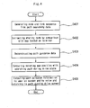
- FIG. 4 is a flowchart showing a vehicle navigation guiding method for guiding a path of a complex intersection according to the present invention.
- a node and a link sequence are generated from a path searching data (S401).
- the path searching data can be provided from the external server 301 or a self-system, specifically the path searching unit 307.
- the node and the link can be generated through parsing of the received path searching data.
- the node and the link sequence can be generated from a path searching result itself without any additional parsing process because a searching target is the same node and link.
- the node and the link sequence are compared with a map for a terminal use to extract terminal sharing node and link (S402).
- a path guidance data of the complex intersection is reconstructed using the extracted sharing node and link (S403).
- the reconstruction of the path guidance data means the reconstruction of the node and link data of the complex intersection.
- the reconstruction of the path guidance data means that a grouping is performed using the sharing node and link of the complex intersection and then the grouped complex intersection is patterned.
- the complex intersection may be judged as one intersection.
- one intersection is configured with several nodes in order to secure inter-link traffic regulation and link connectivity in a process of creating a navigation numeric map for the vehicle navigation system.
- the intersection configured with one or more nodes is defined as the complex intersection.
- a typical type of the complex intersection is a crossroad intersection (i.e., a radial intersection) including a small-sized ramp for a right turn.
- an intersection configured with three or more connection link at one node is defined as a simple intersection.
- Such a complex intersection can be extracted in a general navigation numeric map.
- a conception of a basic extraction method is to create a navigation numeric map so that an intersection configuration link which is not classified as an actual road network can have the same attribute.
- the present invention is a technology that is applied to a local intersection judgment, it is different from a conventional method for extracting a ramp attribute reference, which is configured with a combination of branch links with respect to main link.
- the complex intersection judging method using the extracted sharing node includes the steps of: defining complex intersection configuration nodes of the navigation numeric map; grouping the extracted sharing nodes by using the defined intersection name attribute; and judging the complex intersection as a nodeset if a connectivity between the grouped nodes is secured.
- each node of the complex intersection can be defined to have the same name according to the intersection name attribute.
- the corresponding intersection name can be defined as a unique one within a national map.
- the complex intersection judging method using the extracted link includes the steps of: defining complex intersection configuration links of the navigation numeric map; grouping the extracted links by using the intra-intersection link attribute; and judging a link, which is not the intra- intersection link among the grouped links, as a connection link.
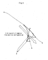
- FIG. 5 is a view exemplarily showing an application of the grouping of the complex intersection according to the present invention.
- FIG. 5 illustrates an application of the complex intersection grouped by an actual complex intersection configuration according to the method using the intra-intersection link attribute according to the present invention.
- the complex intersection is configured by the grouping, so that a connectivity with respect to the same attribute of adjacent links can be secured.
- the node and link of the complex intersection configured as above is patterned through a simplifying process in order for an application to the path guidance screen configuration.
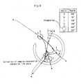
- FIG. 6 is a flowchart showing a method for generating the complex intersection pattern according to the present invention.
- the center of the complex intersection configuration node extracted by the grouping is designated as the center of the complex intersection (S601).
- an actual pattern can be managed as an additional information since it is independent of a position of a navigation numeric map.
- the complex intersection configuration node connected to the link that is judged as the connection link of the complex intersection is indexed in a clockwise (or counterclockwise) direction in reference of due north direction with respect to the center of the complex intersection (S602).
- connection angle of the connection link connected to a progressing direction of the indexed node is extracted (S603).
- the connection angle can be calculated using a node coordinate, an initial pattern point coordinate of a progressing direction from the node to an outside of the complex intersection, and a vector inner-product calculated from a vector coordinate of a due north direction.
- the connection angle can be extracted from the path searching data attribute that is received from the terminal map or the server.
- FIG. 7 is a view schematically showing examples of the integration between adjacent links of the complex intersection connection link according to the present invention.
- case 1 which is capable of passing in an opposite direction arranged in parallel due to a division of two-way road
- a traffic regulation of the link is one-way road and the links have less than 5° in a difference between the connection angles, they are integrated by an average of angle and the intersection pattern configured with the one-way road is generated.
- the corresponding links can be defined as links divided on a topology or a road network and then integrated.
- each link itself is patterned without any integrating process.
- FIG. 8 is an exemplary view schematically showing the construction of the complex intersection configuration data according to the present invention.
- the links are integrated in the same manner according to an indexing rule.
- the connectivity with respect to an entry/exit of the connection link of the complex intersection is secured even when the links are integrated by the link angle and represented as a single road.
- FIG. 9 is an exemplary view schematically showing the addition of the special intersection attrition according to the present invention. As shown in FIG. 9, in case a P-turn path exists within the complex intersection, or in case a corresponding complex intersection is a rotary intersection in a classification of the intersection name, the center of the intersection is represented by a circular rotary.
- the data reconstruction with respect to the complex intersection is completed by adding the special intersection attribute.
- FIG. 10 is an exemplary view schematically showing a reconstruction of a complex intersection by using a complex intersection data according to the present invention.
- the complex intersection data to be provided to the user can be reconstructed by configuring the complex intersection through the grouping process and patterning the configured complex intersection.
- the complex intersection data generated according to the complex intersection reconstructing method of the present invention is constructed as shown in FIG. 2 and previously included as an attribute in the navigation numeric map.
- the followed path guiding information is provided to the user on a screen and by a voice.
- the screen provided to the user returns to the path guiding drive screen after passing the guided place.
Landscapes
- Engineering & Computer Science (AREA)
- Radar, Positioning & Navigation (AREA)
- Remote Sensing (AREA)
- Automation & Control Theory (AREA)
- Physics & Mathematics (AREA)
- General Physics & Mathematics (AREA)
- Navigation (AREA)
- Traffic Control Systems (AREA)
- Instructional Devices (AREA)
Applications Claiming Priority (2)
| Application Number | Priority Date | Filing Date | Title |
|---|---|---|---|
| KR1020020060708A KR100542014B1 (ko) | 2002-10-04 | 2002-10-04 | 복합교차로 경로 안내를 위한 차량 항법유도방법 |
| KR2002060708 | 2002-10-04 |
Publications (2)
| Publication Number | Publication Date |
|---|---|
| EP1411486A2 true EP1411486A2 (de) | 2004-04-21 |
| EP1411486A3 EP1411486A3 (de) | 2004-05-26 |
Family
ID=32040973
Family Applications (1)
| Application Number | Title | Priority Date | Filing Date |
|---|---|---|---|
| EP03022393A Withdrawn EP1411486A3 (de) | 2002-10-04 | 2003-10-06 | Fahrzeugnavigationssystem |
Country Status (5)
| Country | Link |
|---|---|
| US (1) | US7349801B2 (de) |
| EP (1) | EP1411486A3 (de) |
| JP (1) | JP4292545B2 (de) |
| KR (1) | KR100542014B1 (de) |
| RU (1) | RU2270480C2 (de) |
Cited By (1)
| Publication number | Priority date | Publication date | Assignee | Title |
|---|---|---|---|---|
| WO2019086055A3 (zh) * | 2017-11-03 | 2019-06-27 | 华为技术有限公司 | 路口区域路网数据生成方法及装置 |
Families Citing this family (16)
| Publication number | Priority date | Publication date | Assignee | Title |
|---|---|---|---|---|
| KR100679400B1 (ko) * | 2004-12-27 | 2007-02-05 | 엘지전자 주식회사 | 네비게이션 시스템에서 이동체의 주행경로 안내방법 |
| KR100761261B1 (ko) * | 2005-12-01 | 2007-09-28 | 엘지전자 주식회사 | 지도 정합을 위한 임계 거리 결정 방법, 및 이를 적용한지도 정합 방법 및 장치 |
| RU2435138C2 (ru) * | 2006-03-08 | 2011-11-27 | Томтом Интернэшнл Б.В. | Навигационное устройство и способ для осуществления аудиовозможностей в навигационном устройстве |
| EP2042831A4 (de) * | 2006-07-14 | 2010-10-13 | Honda Motor Co Ltd | Navigationsserver, navigationseinrichtung und navigationssystem |
| JP4869106B2 (ja) * | 2007-02-28 | 2012-02-08 | アルパイン株式会社 | ナビゲーション装置およびその交差点拡大図表示方法並びに地図情報作成方法 |
| RU2010121151A (ru) | 2007-10-26 | 2011-12-10 | Томтом Интернэшнл Б.В. (Nl) | Способ обработки данных позиционирования |
| DE102007057715A1 (de) * | 2007-11-30 | 2009-06-04 | Robert Bosch Gmbh | Verfahren zur Routenbestimmung und Anordnung dazu |
| DE102008025053B4 (de) * | 2008-01-18 | 2023-07-06 | Garmin Switzerland Gmbh | Navigationseinrichtung |
| US8417448B1 (en) | 2010-04-14 | 2013-04-09 | Jason Adam Denise | Electronic direction technology |
| GB201307550D0 (en) | 2013-04-26 | 2013-06-12 | Tomtom Dev Germany Gmbh | Methods and systems of providing information indicative of a recommended navigable stretch |
| CN103256936A (zh) * | 2013-05-31 | 2013-08-21 | 深圳市凯立德欣软件技术有限公司 | 一种导航方法及定位导航设备 |
| KR101567151B1 (ko) * | 2013-12-03 | 2015-11-13 | 현대자동차주식회사 | 내비게이션 경로 탐색 방법 및 이를 위한 장치 |
| CN104282151A (zh) * | 2014-09-30 | 2015-01-14 | 北京交通发展研究中心 | 基于高频卫星定位数据的实时浮动车路径匹配方法 |
| DE102016204912B3 (de) * | 2016-03-24 | 2017-09-07 | Volkswagen Aktiengesellschaft | Verfahren zum Verarbeiten geographischer Straßenkreuzungsdaten |
| CN113688192B (zh) * | 2020-05-18 | 2022-07-26 | 百度在线网络技术(北京)有限公司 | 一种路口模型建立方法、装置、设备及介质 |
| CN112991134B (zh) * | 2021-05-11 | 2021-08-27 | 交通运输部科学研究院 | 行车路径还原测算方法、装置和电子设备 |
Citations (3)
| Publication number | Priority date | Publication date | Assignee | Title |
|---|---|---|---|---|
| EP0848232A2 (de) | 1996-12-12 | 1998-06-17 | Xanavi Informatics Corporation | Kartographisches Datenbankgerät |
| US6184823B1 (en) * | 1998-05-01 | 2001-02-06 | Navigation Technologies Corp. | Geographic database architecture for representation of named intersections and complex intersections and methods for formation thereof and use in a navigation application program |
| EP1347269A1 (de) * | 2002-03-19 | 2003-09-24 | Pioneer Corporation | Routenführungsvorrichtung und -verfahren für Kreisverkehr |
Family Cites Families (15)
| Publication number | Priority date | Publication date | Assignee | Title |
|---|---|---|---|---|
| JPH06162395A (ja) * | 1992-11-25 | 1994-06-10 | Matsushita Electric Works Ltd | 自動車ナビゲーションシステム |
| JP2917825B2 (ja) * | 1994-09-08 | 1999-07-12 | 松下電器産業株式会社 | 経路選出方法およびシステム |
| JP3371569B2 (ja) * | 1994-09-29 | 2003-01-27 | 株式会社デンソー | 経路誘導装置 |
| JP2826079B2 (ja) * | 1995-04-21 | 1998-11-18 | 株式会社ザナヴィ・インフォマティクス | 車載用地図データベース装置 |
| JPH08327380A (ja) * | 1995-05-29 | 1996-12-13 | Sony Corp | ナビゲーション装置及び表示方法 |
| JPH09222331A (ja) * | 1996-02-20 | 1997-08-26 | Nissan Motor Co Ltd | 車両用ナビゲーション装置 |
| US6061628A (en) * | 1996-04-24 | 2000-05-09 | Aisin Aw Co., Ltd. | Navigation system for vehicles |
| US5902350A (en) * | 1996-10-30 | 1999-05-11 | Visteon Technologies, Llc | Generating a maneuver at the intersection through a turn lane |
| JP3270383B2 (ja) * | 1997-01-29 | 2002-04-02 | 松下電器産業株式会社 | 経路選出方法およびシステム |
| JP3341645B2 (ja) * | 1997-10-02 | 2002-11-05 | 住友電気工業株式会社 | 経路案内装置 |
| JP3471003B2 (ja) * | 2000-02-02 | 2003-11-25 | 松下電器産業株式会社 | 交差点表示方法およびその地図表示装置並びに記録媒体 |
| DE10010608A1 (de) * | 2000-03-03 | 2001-09-06 | Mannesmann Vdo Ag | Navigationsverfahren mit geringer Datenmenge |
| KR20020045776A (ko) * | 2000-12-11 | 2002-06-20 | 정임수 | 교통정보 서비스 제공 방법 및 시스템 |
| CN1258075C (zh) * | 2001-02-14 | 2006-05-31 | 松下电器产业株式会社 | 车载导向系统 |
| KR100648342B1 (ko) * | 2003-02-10 | 2006-11-23 | 엘지전자 주식회사 | 네비게이션 시스템 및 그 동작 방법 |
-
2002
- 2002-10-04 KR KR1020020060708A patent/KR100542014B1/ko not_active Expired - Fee Related
-
2003
- 2003-10-02 RU RU2003129285/11A patent/RU2270480C2/ru not_active IP Right Cessation
- 2003-10-03 US US10/678,381 patent/US7349801B2/en not_active Expired - Lifetime
- 2003-10-06 JP JP2003346968A patent/JP4292545B2/ja not_active Expired - Lifetime
- 2003-10-06 EP EP03022393A patent/EP1411486A3/de not_active Withdrawn
Patent Citations (3)
| Publication number | Priority date | Publication date | Assignee | Title |
|---|---|---|---|---|
| EP0848232A2 (de) | 1996-12-12 | 1998-06-17 | Xanavi Informatics Corporation | Kartographisches Datenbankgerät |
| US6184823B1 (en) * | 1998-05-01 | 2001-02-06 | Navigation Technologies Corp. | Geographic database architecture for representation of named intersections and complex intersections and methods for formation thereof and use in a navigation application program |
| EP1347269A1 (de) * | 2002-03-19 | 2003-09-24 | Pioneer Corporation | Routenführungsvorrichtung und -verfahren für Kreisverkehr |
Cited By (2)
| Publication number | Priority date | Publication date | Assignee | Title |
|---|---|---|---|---|
| WO2019086055A3 (zh) * | 2017-11-03 | 2019-06-27 | 华为技术有限公司 | 路口区域路网数据生成方法及装置 |
| US11454513B2 (en) | 2017-11-03 | 2022-09-27 | Huawei Technologies Co., Ltd. | Method and apparatus for generating road network data of intersection area |
Also Published As
| Publication number | Publication date |
|---|---|
| RU2270480C2 (ru) | 2006-02-20 |
| JP2004125798A (ja) | 2004-04-22 |
| KR100542014B1 (ko) | 2006-01-10 |
| US7349801B2 (en) | 2008-03-25 |
| KR20040031317A (ko) | 2004-04-13 |
| EP1411486A3 (de) | 2004-05-26 |
| RU2003129285A (ru) | 2005-04-10 |
| JP4292545B2 (ja) | 2009-07-08 |
| US20040068369A1 (en) | 2004-04-08 |
Similar Documents
| Publication | Publication Date | Title |
|---|---|---|
| US7349801B2 (en) | Vehicle navigation system and method for guiding path of complex intersection | |
| JP3521817B2 (ja) | ナビゲーション装置 | |
| EP2352969B1 (de) | Verfahren zum erzeugen von kartendaten, die transitzeiten für kreuzungen umfassen | |
| US7499799B2 (en) | Apparatus and method for downloading and displaying images relating to global positioning information in a navigation system | |
| US6505117B1 (en) | Method for navigating an object | |
| EP3350618B1 (de) | Verfahren und system zur positionsschätzung und navigation autonomer fahrzeuge | |
| KR100822010B1 (ko) | 교통정보 수집용 수치지도를 이용한 교통정보 제공 시스템및 방법 | |
| EP0702210A2 (de) | Fahrzeugnavigationsgerät welches Verkehrsnachrichten verwendet | |
| EP1553385A1 (de) | Übertragungsverfahren für geographische daten, informationsabliefervorrichtung und informationsendgerät | |
| EP0935227A2 (de) | System und Endgerät zur Bereitstellung von Karteninformationen | |
| US20100029293A1 (en) | Navigation system using camera | |
| US20040249569A1 (en) | Apparatus and method for providing travel route in navigation system | |
| EP1772705A1 (de) | Navigationssystem, routensucheinrichtung, navigationseinrichtung und programm | |
| US7197320B2 (en) | System for managing traffic patterns using cellular telephones | |
| EP1589511A1 (de) | Vorrichtung und Verfahren zur Verarbeitung von Verkehrsinformationen | |
| US20040083056A1 (en) | Method and apparatus for guiding intersection in navigation system | |
| JP4856952B2 (ja) | デジタル地図の位置情報伝達方法とそれを実施するプログラム、プログラム製品、システム及び装置 | |
| EP1258851A2 (de) | Navigationsgerät | |
| KR102491779B1 (ko) | 복합 운송에서의 데이터 융합 및 공통 메세지 포맷 기반 실내외 연속측위 산출 장치 및 방법 | |
| Yu | Improved positioning of land vehicle in ITS using digital map and other accessory information | |
| JP2005016955A (ja) | 車載用ナビゲーション装置及び車載用ナビゲーション装置の測位方法 | |
| KR20160035333A (ko) | 차량용 최적 경로 안내 시스템, 및 차량용 최적 경로 안내 시스템을 위한 경로 계산 서버 | |
| JPH08166247A (ja) | 車載ナビゲーション装置 | |
| JPH01161111A (ja) | 移動体用ナビゲーシヨン装置 | |
| KR100684004B1 (ko) | 경로 안내를 위한 차량 항법 유도방법 및 경로 안내 정보추출 방법 |
Legal Events
| Date | Code | Title | Description |
|---|---|---|---|
| PUAI | Public reference made under article 153(3) epc to a published international application that has entered the european phase |
Free format text: ORIGINAL CODE: 0009012 |
|
| PUAL | Search report despatched |
Free format text: ORIGINAL CODE: 0009013 |
|
| AK | Designated contracting states |
Kind code of ref document: A2 Designated state(s): AT BE BG CH CY CZ DE DK EE ES FI FR GB GR HU IE IT LI LU MC NL PT RO SE SI SK TR |
|
| AX | Request for extension of the european patent |
Extension state: AL LT LV MK |
|
| AK | Designated contracting states |
Kind code of ref document: A3 Designated state(s): AT BE BG CH CY CZ DE DK EE ES FI FR GB GR HU IE IT LI LU MC NL PT RO SE SI SK TR |
|
| AX | Request for extension of the european patent |
Extension state: AL LT LV MK |
|
| RIC1 | Information provided on ipc code assigned before grant |
Ipc: 7G 01C 21/30 B Ipc: 7G 01C 21/34 B Ipc: 7G 08G 1/0968 A |
|
| 17P | Request for examination filed |
Effective date: 20041126 |
|
| AKX | Designation fees paid |
Designated state(s): DE FR GB |
|
| 17Q | First examination report despatched |
Effective date: 20110118 |
|
| STAA | Information on the status of an ep patent application or granted ep patent |
Free format text: STATUS: THE APPLICATION IS DEEMED TO BE WITHDRAWN |
|
| 18D | Application deemed to be withdrawn |
Effective date: 20180717 |