EP1134551A1 - Navigationsgerät - Google Patents
Navigationsgerät Download PDFInfo
- Publication number
- EP1134551A1 EP1134551A1 EP01102958A EP01102958A EP1134551A1 EP 1134551 A1 EP1134551 A1 EP 1134551A1 EP 01102958 A EP01102958 A EP 01102958A EP 01102958 A EP01102958 A EP 01102958A EP 1134551 A1 EP1134551 A1 EP 1134551A1
- Authority
- EP
- European Patent Office
- Prior art keywords
- data
- navigation device
- information
- navigation
- processing unit
- Prior art date
- Legal status (The legal status is an assumption and is not a legal conclusion. Google has not performed a legal analysis and makes no representation as to the accuracy of the status listed.)
- Granted
Links
- 238000012545 processing Methods 0.000 claims abstract description 53
- 238000004891 communication Methods 0.000 claims abstract description 16
- 238000013439 planning Methods 0.000 claims abstract description 7
- 238000002360 preparation method Methods 0.000 claims abstract description 5
- 230000008859 change Effects 0.000 claims description 4
- 230000009466 transformation Effects 0.000 description 11
- 238000013500 data storage Methods 0.000 description 6
- 230000005540 biological transmission Effects 0.000 description 5
- 230000006870 function Effects 0.000 description 5
- 238000012546 transfer Methods 0.000 description 5
- 230000009467 reduction Effects 0.000 description 4
- 238000007726 management method Methods 0.000 description 2
- 230000008901 benefit Effects 0.000 description 1
- 238000013523 data management Methods 0.000 description 1
- 230000007547 defect Effects 0.000 description 1
- 238000011161 development Methods 0.000 description 1
- 230000018109 developmental process Effects 0.000 description 1
- 238000010586 diagram Methods 0.000 description 1
- 230000007257 malfunction Effects 0.000 description 1
- 238000000034 method Methods 0.000 description 1
- 230000006855 networking Effects 0.000 description 1
- 230000008569 process Effects 0.000 description 1
- 238000000926 separation method Methods 0.000 description 1
- 238000000638 solvent extraction Methods 0.000 description 1
- 230000001360 synchronised effect Effects 0.000 description 1
Images


Classifications
-
- G—PHYSICS
- G01—MEASURING; TESTING
- G01C—MEASURING DISTANCES, LEVELS OR BEARINGS; SURVEYING; NAVIGATION; GYROSCOPIC INSTRUMENTS; PHOTOGRAMMETRY OR VIDEOGRAMMETRY
- G01C21/00—Navigation; Navigational instruments not provided for in groups G01C1/00 - G01C19/00
- G01C21/26—Navigation; Navigational instruments not provided for in groups G01C1/00 - G01C19/00 specially adapted for navigation in a road network
- G01C21/34—Route searching; Route guidance
- G01C21/36—Input/output arrangements for on-board computers
- G01C21/3667—Display of a road map
Definitions
- the invention relates to a navigation device, in particular for Vehicles according to the preamble of claim 1.
- the main components of such a navigation device or Vehicle navigation systems are a control unit for starting, Intermediate destination and / or destination entry; a data carrier for navigation data, such as B. for information on the representation of Road maps; a navigation computer to carry out the Route planning and route guidance; a data processing unit for the preparation of data in image information, the Data processing unit usually an image memory for Saving the image information contains and a screen or a display unit for displaying street maps, Position information, destination information, etc. Show frequently such navigation devices also include a number of sensors Determination of the vehicle position, the speed of the Orientation etc.
- a navigation device known which as a central unit a microcontroller having.
- a GPS Global Positioning System
- a direction sensor a direction sensor
- a distance sensor a distance sensor
- a traffic information receiver connected to this microcontroller.
- a data storage connected on which information about that Road network, in particular road maps, are stored.
- the data supplied from these components to the microcontroller are a navigation computer to carry out the Route planning provided.
- the data calculated in this way are then also connected to the microcontroller Screen appears.
- road map information cannot be displayed directly, but initially converted into image information by a suitable transformation Need to become.
- Newer systems give the user the possibility to display the Image section through zoom or scroll functions free to choose. Furthermore, in such systems the Direction and movement of the vehicle in the on-screen shown road maps. Through this so-called user requirements (zoom or scroll functions) and system requirements (vehicle movement) changes the image information to be displayed constantly and must be from suitable Road map information is constantly updated.
- EP 0 306 088 A1 there is a newer generation navigation device described.
- the individual components of this navigation device are connected to each other via a data bus.
- a such networking is in so-called networked driver information systems common.
- the advantage of such networked Driver information systems is that almost any Number of individual components via a data bus line can be linked together.
- the screen not only to display navigation data, Road maps etc. are used, but serves for example also for displaying a defect or the like in the vehicle.
- the navigation device described in EP 0 306 088 A1 is based on a data bus, one connected to the data bus Data storage on which a variety of road maps and Navigation data is stored; one connected to the data bus Navigation computer for route planning; one on data processing unit connected to the data bus Processing of data in image information, the data processing unit an image memory for storing the Contains image information; one to the data processing unit connected screen on which the image information can be displayed and with a communication block an operating unit for starting, intermediate and / or destination entry.
- each image information is a road map individually loaded into the image memory.
- the transfer Such picture information always takes place via the bus line.
- a user wants the current screen display change or guide the movement of the vehicle that the image information is constantly changing, so is a transmission of the road map information from the data storage in the image storage necessary.
- a large bandwidth of the data bus necessary which in the Rule does not exist.
- the data bus almost exclusively required for the image information transfer, so that other information or data is not or only can be transferred sequentially in the remaining split times are.
- the first generation is the central unit of a navigation computer 1.
- This navigation computer 1 is information from the outside fed.
- the navigation computer receives this information from a sensor block 10, a Data memory 2 and a communication block 20.
- a direction sensor 12 is in the sensor block 10 and a position sensor 13 included.
- the data storage 2 stores information about road networks. These include in particular Information on the display of road maps, Information about traffic routing, information about Road speed limits and other navigation data.
- This data memory 2 is usually a CD-ROM executed, but any other storage medium is also conceivable. While on the data store 2 such data are saved, which an update in larger In the example, time intervals require the communication block 20 provided for the navigation computer 1 itself to supply constantly changing information via navigation data.
- This communication block 20 contains an operating unit 21 for destination entry and function setting of the screen, especially for the selection of a road map section (Zoom and / or scroll functions).
- this communication block 20 in the example also a traffic data receiver 22 assigned, for example, by different Radio stations receive current traffic information and can process accordingly.
- the navigation computer 1 supplied or feedable data from this Navigation computer 1 for performing route planning and used for route guidance.
- a road map display calculated in this way should then be fed to a screen 4.
- Such road map information generated by the navigation computer 1 cannot be displayed directly, but must go through a suitable transformation in image information being transformed.
- the navigation computer 1 In today's navigation systems or navigation devices the navigation computer 1 usually directly one for it provided provided data processing unit 30.
- the data provided by the sensor block 10 are not solely from the navigation computer 1 to carry out the route planning and route guidance needed, but the movements of the In such vehicle navigation systems or Navigation devices are shown on the screen 4. Furthermore, it is common for navigation devices that the User, for example, the road map section to be viewed can choose. For this, the user has, for example the possibility of zoom and / or scroll functions to execute. Such requirements of the user are in the Designation marked with the reference symbol B. Conditions, which are transmitted directly from the vehicle and due to which the image information to be displayed changes is referred to as system requirement S in the example. Preferably is such a system requirement S on the basis of made available to the sensor block 10. These system requirements S or User requirements B in the drawing on the requirements line 6 fed to the navigation computer 1.
- Data processing unit 30 is unable to meet user requests B and / or system requirements S. and generate new image information from it.
- Such a driver information system it is intended to transmit current data to the driver, for example about the condition of the vehicle, malfunctions etc.
- the individual components of such a driver information system are sensors, input devices, radio receivers, Amplifiers, loudspeakers, display devices, screens etc. They are common, standardized Networked bus.
- FIG. 2 shows how the individual components of such Navigation device in such a driver information system is integrated.
- FIG. 2 shows in particular how such a navigation device according to EP 0 306 088 with the Individual components known from FIG. 1 with a bus structure is to be realized.
- a navigation computer 1, a data memory, are connected to a data bus 3 2, a control unit 39 and a sensor block 10 connected.
- a communication block 20 also closes and a transformation unit 31.
- the transformation unit 31 is connected to an image memory 32 and this Image memory 32 in turn with a screen 4.
- Components 20 and 31 are designed as standard modules and are therefore outside of the navigation system or navigation device even from other devices connected to it controllable.
- System requirements S and / or user requirements B according to FIG. 1 are therefore generally not at all is editable or a smooth screen display not guaranteed.
- the object of the invention is now a navigation device to introduce which is suitable for networked driver information systems suitable and where road map information from Navigation computer to the data processing unit and thus to Screen are so transferable that a limited Bandwidth of the data bus still a sufficient refresh rate is possible.
- this object is achieved by a navigation device with the characterizing features of claim 1.
- the data processing unit itself has a road map memory for storing road map information.
- This road map memory is already used by the navigation computer caching transmitted information.
- This information available locally in the data processing unit are available for screen display if required, without communication with the navigation computer is required.
- This newly transmitted information displaces possibly the outdated and no longer needed Information from the road map memory of the data processing unit. Direct access to the data processing unit on the data storage is due to the software modularization unfavorable in the navigation computer.
- the data bus as "Media Oriented Synchronous Transfer” - (MOST) or as a “Multi Media Link” (MML) bus.
- MOST Media Oriented Synchronous Transfer
- MML Multi Media Link
- the communication block is an operating unit for input a user request to change the current one Has image information and a traffic data receiver for Receive current traffic information. It is irrelevant whether this information directly to the navigation computer can be supplied or via the data bus.
- the control unit for The user request can also be entered, for example Data processing unit to be assigned when an input for example via a touch screen.
- a position sensor is for example for position data acquisition provided for detecting a current actual position and / or a direction sensor for detecting an instantaneous Orientation of the vehicle, as well as a speed sensor and / or a rotation rate sensor.
- the position data detected by the sensor block a system requirement to change a current one Contains image information.
- the system requirements provided will be the Data processing unit supplied, which is a road map from the card memory suitable in image information transformed or further map information from the navigation computer requests.
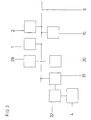
- FIG. 3 shows an example of how a navigation device in a data bus structure according to the invention is realized.
- a navigation computer is connected to a data bus 3 1, a data memory 2 and a data processing unit 30 on.
- a data bus 3 1 a data bus 3 1
- a data memory 2 a data memory 2
- a data processing unit 30 on.
- the navigation computer 1 is supplied with data.
- data for example a speed sensor 11, a direction sensor 12, a position sensor 13 and a rotation rate sensor 14 outlined.
- the navigation computer 1 in analogously from the communication block 20, in particular the control unit 21 and the traffic data receiver 22 information fed.
- this information can of the communication block 20 and the sensor block 10 can also be transmitted via the data bus 3.
- a new request S / B processed largely locally in the data processing unit 30 becomes.
- the invention therefore provides that the standard units Screen 4, image memory 32 and transformation unit 31 a control unit 39 is arranged, which the user requirements B and system requirements S via the Request line 6 are supplied.
- a card memory 38 which is suitable for a larger amount from the Data memory 2 via data bus 3 to navigation computer 1 store supplied road map information.
- the control unit 39 itself is for this purpose by means of a network adapter 37 connected to data bus 3.
- An embodiment variant is that the data store 2 does not hang on the data bus 3 but on the navigation computer 1.
- the data processing unit 30 is designed such that that user requirements B meet system requirements S independent of the navigation computer 1, d. H. processed locally can and that only when needed new card information active from navigation computer 1 according to the client-server principle be requested.
- the next to the image memory 32 in the Data processing unit 30 is arranged card memory 38 capable of map information transmitted by the navigation computer 1 caching.
- the control unit 39 Since the vehicle movement is usually continuous, can be done by suitable arithmetic operations or control operations the control unit 39 recognize early on, what card information below based on system requirements S are needed. Such card information can already look ahead from the navigation computer 1 requested and the card memory 38 are supplied. Thereby there is more time available for this transfer. This leads to a further reduction in the bandwidth requirement of the data bus 3 and for a corresponding relief of the entire network.
- the new vehicle position and / or orientation gives way only insignificantly from the current one, so it is with large display scale may be unnecessary, a new one Image to calculate because of the differences from the current in the frame the given resolution would not be visible anyway.
- the processing of the new request has ended (c).
- the required card information (e) is requested Via the data bus 3 at the navigation computer 1. This sends the requested card information via the data bus 3 the data processing unit 30. Since the card information are usually available in full pages, too transfer entire pages.
- the card information is stored in the data processing unit 30 received by network adapter 37 (f) and by the control unit 39 in the card memory 38 for later access inserted (g).
- the new image information can then be in the transformation unit 31 calculated, stored in the image memory 32 and on the screen 4 are output (h).
Landscapes
- Engineering & Computer Science (AREA)
- Radar, Positioning & Navigation (AREA)
- Remote Sensing (AREA)
- Automation & Control Theory (AREA)
- Physics & Mathematics (AREA)
- General Physics & Mathematics (AREA)
- Navigation (AREA)
- Traffic Control Systems (AREA)
- Instructional Devices (AREA)
Abstract
Description
- Figur 1
- eine Anordnung eines Navigationsgerätes der ersten Generation ohne Datenbus gemäß dem Stand der Technik,
- Figur 2
- ein Navigationsgerät der zweiten Generation mit einem Datenbus nach dem Stand der Technik,
- Figur 3
- ein Ausführungsbeispiel eines erfindungsgemäßen Navigationsgeräts,
- Figur 4
- ein Flußdiagramm zur Demonstration einer Verwaltung und Verarbeitung der in dem Karten speicher der Datenaufbereitungseinheit gespeicherten Straßenkarten.
- 1
- Navigationsrechner
- 2
- Datenspeicher
- 3
- erster Datenbus
- 4, 4a, 4b
- Bildschirm
- 6
- Anforderungsleitung
- 7
- weitere Komponente
- 10
- Sensorblock
- 11
- Geschwindigkeitssensor
- 12
- Richtungssensor
- 13
- Positionssensor
- 14
- Drehratensensor
- 20
- Kommunikationsblock
- 21
- Bedieneinheit
- 22
- Verkehrsdatenempfänger
- 30, 30a, 30b
- Datenaufbereitungseinheit
- 31
- Transformationseinheit
- 32
- Bildspeicher
- 37
- Netzwerkadapter
- 38
- Kartenspeicher
- 39
- Kontrolleinheit
- B
- Benutzeranforderung
- S
- Systemanforderung
Claims (13)
- Navigationsgerät, insbesondere für Fahrzeuge,dadurch gekennzeichnet,dass die Datenaufbereitungseinheit (30) einen Kartenspeicher (38) zum Speichern von Straßenkarteninformationen aufweist.(a) mit einem Datenbus (3),(b) mit einem Datenspeicher (2) auf dem eine Vielzahl von Straßenkarteninformationen und Navigationsdaten gespeichert sind,(c) mit einem an den Datenbus (3) angeschlossenen Navigationsrechner (1) zur Routenplanung,(d) mit einer an den Datenbus (3) angeschlossenen Datenaufbereitungseinheit (30) zur Aufbereitung von Daten in Bildinformationen, wobei die Datenaufbereitungseinheit (30) einen Bildspeicher (32) zum Speichern der Bildinformationen enthält,(e) mit einem an die Datenaufbereitungseinheit (30) angeschlossenen Bildschirm (4), auf dem die Bildinformationen darstellbar sind,(f) mit einem Kommunikationsblock (20) mit einer Bedieneinheit (21) zur Start-, Zwischenziel- und/oder Zieleingabe einer Fahrt,
- Navigationsgerät nach Anspruch 1,
dadurch gekennzeichnet,dass die Datenaufbereitungseinheit (30) eine Kontrolleinheit (39) zur vorausschauenden Anforderung von Karteninformationen aufweist. - Navigationsgerät nach einem der vorangegangenen Ansprüche,
dadurch gekennzeichnet,dass der Kommunikationsblock (20) eine Bedieneinheit (21) zur Eingabe einer Benutzeranforderung (B) zur Änderung der aktuellen Bildinformation aufweist. - Navigationsgerät nach einem der vorangegangenen Ansprüche,
dadurch gekennzeichnet, dass der Kommunikationsblock (20) einen Verkehrsdatenempfänger (22) zum Empfangen aktueller Verkehrsinformationen aufweist. - Navigationsgerät nach einem der vorangegangenen Ansprüche,
dadurch gekennzeichnet,dass dem Navigationsrechner (1) ein Sensorblock (10) zu einer Positionsdatenerfassung zugeordnet ist. - Navigationsgerät nach Anspruch 5,
dadurch gekennzeichnet,dass der Sensorblock (10) zur Positionsdatenerfassung einen Positionssensor (13) zur Erfassung einer momentanen Ist-Position aufweist. - Navigationsgerät nach einem der Ansprüche 5 oder 6,
dadurch gekennzeichnet,dass der Sensorblock (10) zur Positionsdatenerfassung einen Richtungssensor (12) zur Erfassung einer momentanen Orientierung des Fahrzeugs und/oder einen Geschwindigkeitssensor (11) und/oder einen Drehratensensor (14) aufweist. - Navigationsgerät nach einem der Ansprüche 5 bis 7,
dadurch gekennzeichnet,dass die vom Sensorblock (10) erfassten Positionsdaten eine Systemanforderung (S) direkt in der Datenaufbereitungseinheit (30) bewirken, die zur Änderung einer aktuellen Bildinformation führt. - Navigationsgerät nach einem der vorangegangenen Ansprüche,
dadurch gekennzeichnet,dass die Datenaufbereitungseinheit (30) eine Kontrolleinheit (39) zur Verwaltung und Verarbeitung der in dem Kartenspeicher (30) der gespeicherten Straßenkarten aufweist. - Navigationsgerät nach Anspruch 9,
dadurch gekennzeichnet,dass die Kontrolleinheit (39) zur Verwaltung und Verarbeitung der in dem Kartenspeicher (38) gespeicherten Straßenkarten durch die Benutzeranforderung (B) und/oder die Systemanforderung (S) ansteuerbar ist. - Navigationsgerät nach einem der vorangegangenen Ansprüche,
dadurch gekennzeichnet,dass der Datenbus (3) ein MOST-Bus oder ein MML-Bus ist. - Navigationsgerät nach einem der vorangegangenen Ansprüche,
dadurch gekennzeichnet,dass der Navigationsrechner (1) und die Datenaufbereitungseinheit (30) mit zwei separaten µProzessoren realisiert sind. - Navigationsgerät nach einem der vorangegenangen Ansprüche,
dadurch gekennzeichnet,dass zwei oder mehrere unabhängige Datenaufbereitungseinheiten (30, 30a, 30b) und Bildschirme (4, 4a, 4b) voneinander unabhängige Kartenausschnitte darstellen.
Applications Claiming Priority (2)
| Application Number | Priority Date | Filing Date | Title |
|---|---|---|---|
| DE10005878 | 2000-02-10 | ||
| DE10005878A DE10005878B4 (de) | 2000-02-10 | 2000-02-10 | Navigationsgerät |
Publications (2)
| Publication Number | Publication Date |
|---|---|
| EP1134551A1 true EP1134551A1 (de) | 2001-09-19 |
| EP1134551B1 EP1134551B1 (de) | 2011-12-14 |
Family
ID=7630446
Family Applications (1)
| Application Number | Title | Priority Date | Filing Date |
|---|---|---|---|
| EP01102958A Expired - Lifetime EP1134551B1 (de) | 2000-02-10 | 2001-02-08 | Navigationsgerät |
Country Status (4)
| Country | Link |
|---|---|
| US (1) | US6704646B2 (de) |
| EP (1) | EP1134551B1 (de) |
| JP (1) | JP2001289644A (de) |
| DE (1) | DE10005878B4 (de) |
Families Citing this family (10)
| Publication number | Priority date | Publication date | Assignee | Title |
|---|---|---|---|---|
| DE10149862A1 (de) | 2001-10-10 | 2003-05-08 | Daimler Chrysler Ag | Verfahren und Vorrichtung zur Zielauswahl eines Navigationssystems in einem Kraftfahrzeug unter Verwendung einer Dienstezentrale |
| US7474959B2 (en) * | 2004-10-08 | 2009-01-06 | Scenera Technologies, Llc | Method for providing recommendations using image, location data, and annotations |
| JP4581912B2 (ja) * | 2005-08-24 | 2010-11-17 | 株式会社デンソー | ナビゲーション装置 |
| US9175977B2 (en) | 2005-12-20 | 2015-11-03 | General Motors Llc | Method for arbitrating between multiple vehicle navigation systems |
| JP4992405B2 (ja) * | 2006-12-12 | 2012-08-08 | 株式会社デンソー | 車載機器の操作装置 |
| ATE456490T1 (de) * | 2007-10-01 | 2010-02-15 | Harman Becker Automotive Sys | Sprachgesteuerte einstellung von fahrzeugteilen |
| US8050673B2 (en) | 2008-12-29 | 2011-11-01 | General Motors Llc | Primary connection strategy for vehicle originated cellular communication to a call center |
| TWI416079B (zh) * | 2009-12-08 | 2013-11-21 | Mitac Int Corp | 導航系統以及使用此導航系統的路徑規劃方法 |
| DE102013215499A1 (de) * | 2013-08-07 | 2015-02-12 | Bayerische Motoren Werke Aktiengesellschaft | Verfahren zum Betrieb eines Navigationssystems in einem Fahrzeug und entsprechendes Steuerungssystem sowie Computerprogrammprodukt |
| KR20230036002A (ko) * | 2021-09-06 | 2023-03-14 | 현대모비스 주식회사 | 차량 내 헤드유닛과 연동 가능한 차량 탑재 단말기, 차량 시스템 및 그 업데이트 방법 |
Citations (2)
| Publication number | Priority date | Publication date | Assignee | Title |
|---|---|---|---|---|
| US5721684A (en) * | 1995-07-04 | 1998-02-24 | Mitsubishi Denki Kabushiki Kaisha | Navigation apparatus having two processors, the first for outputting map data and the second for drawing and scrolling the map |
| EP0836167A1 (de) * | 1996-08-21 | 1998-04-15 | Aisin Aw Co., Ltd. | Gerät zur Anzeige von Karten und Verfahren dazu |
Family Cites Families (8)
| Publication number | Priority date | Publication date | Assignee | Title |
|---|---|---|---|---|
| NL8702087A (nl) * | 1987-09-04 | 1989-04-03 | Philips Nv | Voertuignavigatie-inrichting met weergave van een geselekteerd kaartelement volgens een voorafbepaalde representatienorm. |
| US5031104A (en) * | 1988-12-05 | 1991-07-09 | Sumitomo Electric Industries, Ltd. | Adaptive in-vehicle route guidance system |
| JP3378031B2 (ja) * | 1992-08-19 | 2003-02-17 | アイシン・エィ・ダブリュ株式会社 | 車両用ナビゲーション装置 |
| CA2158500C (en) * | 1994-11-04 | 1999-03-30 | Ender Ayanoglu | Navigation system for an automotive vehicle |
| JP3483672B2 (ja) * | 1995-09-06 | 2004-01-06 | 三菱電機株式会社 | ナビゲーション装置 |
| JPH10311730A (ja) * | 1997-05-09 | 1998-11-24 | Toyota Motor Corp | 通信機器制御装置 |
| JPH1115372A (ja) * | 1997-06-19 | 1999-01-22 | Toyota Motor Corp | 地図情報提供システム、そのシステムから地図提供を受ける移動局、および、地図情報提供方法 |
| JP3737270B2 (ja) * | 1998-02-18 | 2006-01-18 | アルパイン株式会社 | ナビゲーション装置のデータ転送方法 |
-
2000
- 2000-02-10 DE DE10005878A patent/DE10005878B4/de not_active Expired - Lifetime
-
2001
- 2001-02-08 EP EP01102958A patent/EP1134551B1/de not_active Expired - Lifetime
- 2001-02-09 US US09/780,220 patent/US6704646B2/en not_active Expired - Lifetime
- 2001-02-13 JP JP2001034953A patent/JP2001289644A/ja active Pending
Patent Citations (2)
| Publication number | Priority date | Publication date | Assignee | Title |
|---|---|---|---|---|
| US5721684A (en) * | 1995-07-04 | 1998-02-24 | Mitsubishi Denki Kabushiki Kaisha | Navigation apparatus having two processors, the first for outputting map data and the second for drawing and scrolling the map |
| EP0836167A1 (de) * | 1996-08-21 | 1998-04-15 | Aisin Aw Co., Ltd. | Gerät zur Anzeige von Karten und Verfahren dazu |
Also Published As
| Publication number | Publication date |
|---|---|
| DE10005878A1 (de) | 2001-08-23 |
| EP1134551B1 (de) | 2011-12-14 |
| DE10005878B4 (de) | 2004-07-08 |
| US6704646B2 (en) | 2004-03-09 |
| JP2001289644A (ja) | 2001-10-19 |
| US20030120422A1 (en) | 2003-06-26 |
Similar Documents
| Publication | Publication Date | Title |
|---|---|---|
| EP0805951B1 (de) | Zieleingabe für navigationssystem | |
| DE19842430B4 (de) | Kartendatenverarbeitungsvorrichtung und -verfahren, und Kartendatenverarbeitungssystem | |
| EP2242993B1 (de) | Fahrzeugsystem zur navigation und/oder fahrerassistenz | |
| EP1497618B1 (de) | Verfahren und system zur dynamischen zielführung eines fahrzeuges | |
| EP2195796B1 (de) | Verfahren zur bereitstellung von fahrbetriebsdaten | |
| EP1371047B1 (de) | Aktualisierung von routen- und verkehrsflussdaten sowie fahrzeugnavigationsgerät | |
| DE19535576A1 (de) | Verfahren und Vorrichtung zur Zielführungsunterstützung | |
| DE10016674A1 (de) | Verfahren zur Ausgabe von Daten in einem Fahrzeug und Fahrerinformationsvorrichtung | |
| DE102007046765A1 (de) | Steuerverfahren und System | |
| EP1134551B1 (de) | Navigationsgerät | |
| WO2019072524A1 (de) | Verfahren zur kartierung eines streckenabschnitts | |
| DE102017011694A1 (de) | Transportsystem und Verfahren zum Betreiben eines Transportsystems | |
| DE102019212312A1 (de) | Steuervorrichtung und -verfahren für die Übertragung von Daten zum Fahrzeugumfeld | |
| DE10010310B4 (de) | Verfahren und Vorrichtung zur Darstellung eines geografischen Bildes auf einem Bildschirm | |
| DE102018009908A1 (de) | Verfahren zum Betreiben eines Fahrzeuges beim Auslagern von Rechenleistung aus dem Fahrzeug an mindestens einen Edge-Cloud-Computer | |
| EP2402202B1 (de) | Verfahren zum Betrieb eines wenigstens eine Information an einen Fahrer ausgebende und/oder Informationen von einem Fahrer entgegennehmende Funktionalität aufweisenden Fahrzeugsystems eines Kraftfahrzeuges | |
| EP4646357A1 (de) | Verfahren zum zumindest hochautomatisierten fahren und zum infrastrukturgestützten assistieren eines kraftfahrzeugs innerhalb eines parkplatzes | |
| DE102016013509A1 (de) | Vorrichtung und Verfahren zum Erzeugen einer lernenden digitalen Karte für ein Kraftfahrzeug | |
| EP1901037B1 (de) | Verfahren zur Bestimmung einer Fahrzeit | |
| EP1402232B1 (de) | Verfahren und vorrichtung zur ausgabe von daten zu einem attribut einer digitalen strassenkarte | |
| DE102018216812A1 (de) | Elektronische Steuereinheit | |
| EP3140616B1 (de) | Verfahren zum betrieb eines navigationssystems eines kraftfahrzeugs und kraftfahrzeug | |
| DE102006013297B4 (de) | Verfahren zum Betrieb eines Navigationssystems | |
| DE102023202623B3 (de) | Verfahren zur Verwendung von Navigationsdaten in einem Fahrerassistenzsystem | |
| DE102019002594A1 (de) | Verfahren zur Aktualisierung einer optimalen Routenführung |
Legal Events
| Date | Code | Title | Description |
|---|---|---|---|
| PUAI | Public reference made under article 153(3) epc to a published international application that has entered the european phase |
Free format text: ORIGINAL CODE: 0009012 |
|
| AK | Designated contracting states |
Kind code of ref document: A1 Designated state(s): AT BE CH CY DE DK ES FI FR GB GR IE IT LI LU MC NL PT SE TR |
|
| AX | Request for extension of the european patent |
Free format text: AL;LT;LV;MK;RO;SI |
|
| AKX | Designation fees paid | ||
| 17P | Request for examination filed |
Effective date: 20020314 |
|
| RBV | Designated contracting states (corrected) |
Designated state(s): DE FR GB IT |
|
| REG | Reference to a national code |
Ref country code: DE Ref legal event code: 8566 |
|
| 17Q | First examination report despatched |
Effective date: 20070301 |
|
| GRAP | Despatch of communication of intention to grant a patent |
Free format text: ORIGINAL CODE: EPIDOSNIGR1 |
|
| RAP1 | Party data changed (applicant data changed or rights of an application transferred) |
Owner name: XSYS INTERACTIVE RESEARCH GMBH |
|
| RIN1 | Information on inventor provided before grant (corrected) |
Inventor name: WAGNER, OLIVER Inventor name: WAGNER, THOMAS Inventor name: COCHOOVIUS, ELMAR, DR. |
|
| RIN1 | Information on inventor provided before grant (corrected) |
Inventor name: WAGNER, THOMAS Inventor name: COCHLOVIUS, ELMAR, DR. Inventor name: WAGNER, OLIVER |
|
| GRAS | Grant fee paid |
Free format text: ORIGINAL CODE: EPIDOSNIGR3 |
|
| GRAA | (expected) grant |
Free format text: ORIGINAL CODE: 0009210 |
|
| AK | Designated contracting states |
Kind code of ref document: B1 Designated state(s): DE FR GB IT |
|
| REG | Reference to a national code |
Ref country code: GB Ref legal event code: FG4D Free format text: NOT ENGLISH |
|
| REG | Reference to a national code |
Ref country code: DE Ref legal event code: R096 Ref document number: 50116017 Country of ref document: DE Effective date: 20120308 |
|
| PLBE | No opposition filed within time limit |
Free format text: ORIGINAL CODE: 0009261 |
|
| STAA | Information on the status of an ep patent application or granted ep patent |
Free format text: STATUS: NO OPPOSITION FILED WITHIN TIME LIMIT |
|
| 26N | No opposition filed |
Effective date: 20120917 |
|
| PG25 | Lapsed in a contracting state [announced via postgrant information from national office to epo] |
Ref country code: IT Free format text: LAPSE BECAUSE OF FAILURE TO SUBMIT A TRANSLATION OF THE DESCRIPTION OR TO PAY THE FEE WITHIN THE PRESCRIBED TIME-LIMIT Effective date: 20111214 |
|
| REG | Reference to a national code |
Ref country code: DE Ref legal event code: R097 Ref document number: 50116017 Country of ref document: DE Effective date: 20120917 |
|
| REG | Reference to a national code |
Ref country code: FR Ref legal event code: PLFP Year of fee payment: 16 |
|
| REG | Reference to a national code |
Ref country code: FR Ref legal event code: PLFP Year of fee payment: 17 |
|
| REG | Reference to a national code |
Ref country code: FR Ref legal event code: PLFP Year of fee payment: 18 |
|
| PGFP | Annual fee paid to national office [announced via postgrant information from national office to epo] |
Ref country code: DE Payment date: 20200121 Year of fee payment: 20 Ref country code: GB Payment date: 20200123 Year of fee payment: 20 |
|
| PGFP | Annual fee paid to national office [announced via postgrant information from national office to epo] |
Ref country code: FR Payment date: 20200122 Year of fee payment: 20 |
|
| REG | Reference to a national code |
Ref country code: DE Ref legal event code: R071 Ref document number: 50116017 Country of ref document: DE |
|
| REG | Reference to a national code |
Ref country code: GB Ref legal event code: PE20 Expiry date: 20210207 |
|
| PG25 | Lapsed in a contracting state [announced via postgrant information from national office to epo] |
Ref country code: GB Free format text: LAPSE BECAUSE OF EXPIRATION OF PROTECTION Effective date: 20210207 |