EP1006367A2 - Satellitengestütztes map-matching-Verfahren - Google Patents
Satellitengestütztes map-matching-Verfahren Download PDFInfo
- Publication number
- EP1006367A2 EP1006367A2 EP99440336A EP99440336A EP1006367A2 EP 1006367 A2 EP1006367 A2 EP 1006367A2 EP 99440336 A EP99440336 A EP 99440336A EP 99440336 A EP99440336 A EP 99440336A EP 1006367 A2 EP1006367 A2 EP 1006367A2
- Authority
- EP
- European Patent Office
- Prior art keywords
- satellite
- map matching
- gps
- signal
- board unit
- Prior art date
- Legal status (The legal status is an assumption and is not a legal conclusion. Google has not performed a legal analysis and makes no representation as to the accuracy of the status listed.)
- Withdrawn
Links
Images
Classifications
-
- G—PHYSICS
- G01—MEASURING; TESTING
- G01C—MEASURING DISTANCES, LEVELS OR BEARINGS; SURVEYING; NAVIGATION; GYROSCOPIC INSTRUMENTS; PHOTOGRAMMETRY OR VIDEOGRAMMETRY
- G01C21/00—Navigation; Navigational instruments not provided for in groups G01C1/00 - G01C19/00
- G01C21/26—Navigation; Navigational instruments not provided for in groups G01C1/00 - G01C19/00 specially adapted for navigation in a road network
- G01C21/28—Navigation; Navigational instruments not provided for in groups G01C1/00 - G01C19/00 specially adapted for navigation in a road network with correlation of data from several navigational instruments
- G01C21/30—Map- or contour-matching
-
- G—PHYSICS
- G01—MEASURING; TESTING
- G01S—RADIO DIRECTION-FINDING; RADIO NAVIGATION; DETERMINING DISTANCE OR VELOCITY BY USE OF RADIO WAVES; LOCATING OR PRESENCE-DETECTING BY USE OF THE REFLECTION OR RERADIATION OF RADIO WAVES; ANALOGOUS ARRANGEMENTS USING OTHER WAVES
- G01S19/00—Satellite radio beacon positioning systems; Determining position, velocity or attitude using signals transmitted by such systems
- G01S19/38—Determining a navigation solution using signals transmitted by a satellite radio beacon positioning system
- G01S19/39—Determining a navigation solution using signals transmitted by a satellite radio beacon positioning system the satellite radio beacon positioning system transmitting time-stamped messages, e.g. GPS [Global Positioning System], GLONASS [Global Orbiting Navigation Satellite System] or GALILEO
- G01S19/42—Determining position
- G01S19/48—Determining position by combining or switching between position solutions derived from the satellite radio beacon positioning system and position solutions derived from a further system
- G01S19/49—Determining position by combining or switching between position solutions derived from the satellite radio beacon positioning system and position solutions derived from a further system whereby the further system is an inertial position system, e.g. loosely-coupled
-
- G—PHYSICS
- G01—MEASURING; TESTING
- G01S—RADIO DIRECTION-FINDING; RADIO NAVIGATION; DETERMINING DISTANCE OR VELOCITY BY USE OF RADIO WAVES; LOCATING OR PRESENCE-DETECTING BY USE OF THE REFLECTION OR RERADIATION OF RADIO WAVES; ANALOGOUS ARRANGEMENTS USING OTHER WAVES
- G01S19/00—Satellite radio beacon positioning systems; Determining position, velocity or attitude using signals transmitted by such systems
- G01S19/38—Determining a navigation solution using signals transmitted by a satellite radio beacon positioning system
- G01S19/39—Determining a navigation solution using signals transmitted by a satellite radio beacon positioning system the satellite radio beacon positioning system transmitting time-stamped messages, e.g. GPS [Global Positioning System], GLONASS [Global Orbiting Navigation Satellite System] or GALILEO
- G01S19/40—Correcting position, velocity or attitude
Definitions
- the invention relates to a satellite-based map matching method and an on board unit to carry out the procedure according to Preambles of claims 1 and 3.
- the autonomous position determination is outstanding Importance for various applications, especially for Fleet management, navigation aid and road toll collection systems. Satellite-based methods based on a based on two-dimensional location. The achievable accuracy is included approx. 50 m. By using a DGPS (Differential Global Positioning System), accuracies of up to approx. 5 m can be achieved.
- absolute waypoints for example radio beacons, are becoming known Coordinates for correcting the satellite, i.e. using GPS (Globel Positioning System), determined positions used.
- GPS Global Positioning System
- the object is characterized by the characteristic features of claim 1 solved.
- the invention is based on the knowledge that striking topography features in a special way as reference points own. The coordinates of these reference points become so precise determined as possible and then serve as data material for a map matching system.
- the map matching system compares the GPS data with stored road map data or route data in order in this way For example, determine whether the vehicle is on a chargeable basis Street or not.
- the decision certainty will improved according to the invention in that the precisely measured coordinates, especially of bridges, can be compared with the GPS reading and a corresponding correction value is derived from the deviation.
- this correction value is also used for the calibration of other vehicle-autonomous navigation systems.
- Such calibrated additional navigation systems also allow in the case of a intermittent shading, especially due to bridges or tunnels, of GPS reception is a two-dimensional position determination in one get certain time interval, so that a hundred percent Availability of the vehicle positions is given.
- Claim 3 identifies an on board unit for carrying out the Method, with a GPS receiver and a map matching system, taking topographical waypoints using those in the map matching system stored road data can be recognized and when a certain distance of the vehicle from such a waypoint Receiving field strength of the satellite signals is reduced.
- the GPS receiver for signal processing is set every second. This second resolution is for the detection of shadowing edges, especially at high speeds, no longer sufficient.
- the GPS receiver should be in a certain distance in front of the waypoint to be recorded Field strength detection mode can be switched. This distance can for example set to 150m.
- adjustable GPS receivers can additionally according to claim 5 Selection means to limit the signal evaluation to the most suitable GPS satellites can be provided.
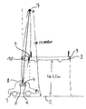
- the figure shows a schematic representation of a vehicle 1 on a Street 2, just before driving through street 2 crossing bridge 3.
- the vehicle 1 is with an on board unit 4 equipped with GPS receiver 5 and map matching system 6.
- a GPS satellite 7 transmits signals, the duration of which is a measure of the position of the Represent vehicle 1 via a GPS antenna 8 to the receiver 5th
- the bridge edge acts as a shading edge 9, so that the direct Satellite reception interrupted by the bridge 3 during the transit time becomes.
- the shading edge 9 can be determined very precisely using the last satellite signal still received to tune the determined position with that stored by the map matching system 6 to compare the absolute position of the shading edge 9. Deviations of a certain size can be used to calculate a correction value be used to correct the satellite signal.
- the invention is not limited to the above Embodiment. Rather, a number of variants are conceivable which, even with a fundamentally different type of execution, Make use of features of the invention.
Abstract
Description
Claims (5)
- Satellitengestütztes map-matching-Verfahren zur fahrzeugautonomen Positionsbestimmung, dadurch gekennzeichnet, daß bei topographisch bedingter Unterbrechung des Empfangs des Satellitensignals, insbesondere bei Tunnel- und Brückendurchfahrt, das Satellitensignal zu Beginn und/oder am Ende der Unterbrechung in bezug auf die bekannten Koordinaten des topographischen Wegpunktes zur Ermittlung eines Korrektursignals zur Korrektur des Satellitensignals verwendet wird/werden.
- Verfahren nach Anspruch 1, dadurch gekennzeichnet, daß der Korrekturwert zur Eichung weiterer fahrzeugautonomer Navigationssysteme, insbesondere mit Tachometer-Wegstreckenmessung - und/oder Kreiselstützung, verwendet wird.
- On Board Unit (4) zur Durchführung des Verfahrens nach einem der vorangehenden Ansprüche, wobei ein GPS-Empfänger (Global-Positioning-System) (5) mit einem map-matching-System (6) zusammenwirkt, dadurch gekennzeichnet, daß das map-matching-System (6) Analysemittel zum Erkennen in einem vorgegebenen Abstand befindlicher und voraussichtlich zu passierender topographischer Wegpunkte aufweist, wobei ein Signalausgang der Analysemittel die Empfangsfeldstärke der Satellitensignale des GPS-Empfängers (5) im Sinne einer Absendung beaufschlagt.
- On Board Unit (4) nach Anspruch 3, dadurch gekennzeichnet, daß der Signalausgang als ereignisgesteuerter Triggerausgang ausgebildet ist.
- On Board Unit (4) nach Anspruch 3 oder 4 mit einem mehrkanaligen, auf mehrere GPS-Satelliten (7) einstellbaren GPS-Empfänger (5), gekennzeichnet durch Auswahlmittel zur Identifizierung und Kanalzuordnung mindestens eines von der Art des topographischen Wegpunktes abhängigen GPS-Satelliten (7), insbesondere eines zenitnahen GPS-Satelliten (7) bei Tunnel- und Brückendurchfahrt.
Applications Claiming Priority (2)
| Application Number | Priority Date | Filing Date | Title |
|---|---|---|---|
| DE19856187A DE19856187A1 (de) | 1998-12-05 | 1998-12-05 | Satellitengestütztes map-matching-Verfahren |
| DE19856187 | 1998-12-05 |
Publications (2)
| Publication Number | Publication Date |
|---|---|
| EP1006367A2 true EP1006367A2 (de) | 2000-06-07 |
| EP1006367A3 EP1006367A3 (de) | 2001-10-17 |
Family
ID=7890108
Family Applications (1)
| Application Number | Title | Priority Date | Filing Date |
|---|---|---|---|
| EP99440336A Withdrawn EP1006367A3 (de) | 1998-12-05 | 1999-12-02 | Satellitengestütztes map-matching-Verfahren |
Country Status (2)
| Country | Link |
|---|---|
| EP (1) | EP1006367A3 (de) |
| DE (1) | DE19856187A1 (de) |
Cited By (13)
| Publication number | Priority date | Publication date | Assignee | Title |
|---|---|---|---|---|
| WO2005076031A3 (en) * | 2003-10-06 | 2005-10-06 | Sirf Tech Inc | A system and method for augmenting a satellite-based navigation solution |
| WO2006086298A3 (en) * | 2005-02-07 | 2007-04-19 | Siemens Vdo Automotive Corp | Navigation system |
| US7880642B2 (en) | 2002-03-05 | 2011-02-01 | Triangle Software Llc | GPS-generated traffic information |
| CN101441262B (zh) * | 2007-11-20 | 2011-11-30 | 锐迪科微电子(上海)有限公司 | 立体交通导航方法和装置 |
| EP2550546A1 (de) * | 2010-03-25 | 2013-01-30 | Cellguide Ltd. | Durch statische daten unterstützte gnss-navigation |
| US8619072B2 (en) | 2009-03-04 | 2013-12-31 | Triangle Software Llc | Controlling a three-dimensional virtual broadcast presentation |
| CN104504898A (zh) * | 2014-12-11 | 2015-04-08 | 王东宇 | 基于浮动车数据的隧道路段在线地图匹配方法 |
| WO2015049044A1 (de) * | 2013-10-02 | 2015-04-09 | Audi Ag | Verfahren zur korrektur von positionsdaten und kraftfahrzeug |
| US9046924B2 (en) | 2009-03-04 | 2015-06-02 | Pelmorex Canada Inc. | Gesture based interaction with traffic data |
| US20150338524A1 (en) * | 2012-06-26 | 2015-11-26 | Ariel-University Research And Development Company Ltd. | Methods and devices for improved position determination |
| CN105551249A (zh) * | 2015-12-31 | 2016-05-04 | 王东宇 | 基于浮动车数据的隧道路段在线地图匹配方法 |
| US9644982B2 (en) | 2003-07-25 | 2017-05-09 | Pelmorex Canada Inc. | System and method for delivering departure notifications |
| US10223909B2 (en) | 2012-10-18 | 2019-03-05 | Uber Technologies, Inc. | Estimating time travel distributions on signalized arterials |
Families Citing this family (10)
| Publication number | Priority date | Publication date | Assignee | Title |
|---|---|---|---|---|
| DE10008061C2 (de) * | 2000-02-22 | 2002-02-07 | Siemens Ag | Verfahren und Vorrichtung zur Positionsbestimmung |
| DE10016178A1 (de) * | 2000-03-31 | 2001-10-11 | Bosch Gmbh Robert | Positionsbestimmungsvorrichtung und Verfahren zum Abgleich eines Positionsbestimmungsverfahrens |
| DE10044393A1 (de) * | 2000-09-08 | 2002-04-04 | Bosch Gmbh Robert | Navigationssystem und Verfahren zur Bestimmung der Fahrbahnebene |
| DE10356496A1 (de) * | 2003-12-03 | 2005-07-07 | Siemens Ag | Verfahren zur Positionsbestimmung einer Teilnehmerstation eines Funkkommunikationssystems sowie Positionsbestimmungseinheit |
| DE102005059284A1 (de) * | 2005-12-12 | 2007-06-14 | Siemens Ag | Verfahren zur Ermittlung von berichtigten aktuellen Positionsdaten insbesondere zur Bestimmung von aktuellen Fahrzeugpositionen |
| US8982116B2 (en) | 2009-03-04 | 2015-03-17 | Pelmorex Canada Inc. | Touch screen based interaction with traffic data |
| EP2638493A4 (de) | 2010-11-14 | 2017-12-13 | Muddy River, Series 97 of Allied Security Trust 1 | Crowdsource-verkehrsnachrichten |
| US8725396B2 (en) | 2011-05-18 | 2014-05-13 | Pelmorex Canada Inc. | System for providing traffic data and driving efficiency data |
| CA2883973C (en) | 2012-01-27 | 2021-02-23 | Edgar Rojas | Estimating time travel distributions on signalized arterials |
| DE102014215570B4 (de) * | 2014-08-06 | 2021-12-30 | Elektrobit Automotive Gmbh | Fahrzeugnavigationssystem |
Citations (2)
| Publication number | Priority date | Publication date | Assignee | Title |
|---|---|---|---|---|
| US5334986A (en) * | 1992-04-09 | 1994-08-02 | U.S. Philips Corporation | Device for determining the position of a vehicle |
| US5374933A (en) * | 1993-01-05 | 1994-12-20 | Zexel Corporation | Position correction method for vehicle navigation system |
Family Cites Families (9)
| Publication number | Priority date | Publication date | Assignee | Title |
|---|---|---|---|---|
| DE3310111A1 (de) * | 1982-07-23 | 1984-09-27 | Teldix Gmbh, 6900 Heidelberg | Navigationsanlage fuer landfahrzeuge |
| DE3227547A1 (de) * | 1982-07-23 | 1984-02-02 | Teldix Gmbh, 6900 Heidelberg | Navigationsanlage |
| JPS61137009A (ja) * | 1984-12-07 | 1986-06-24 | Nissan Motor Co Ltd | 車両用測位装置 |
| JPH02196975A (ja) * | 1989-01-26 | 1990-08-03 | Nissan Motor Co Ltd | 車両用gps航法装置 |
| KR940009235B1 (ko) * | 1990-09-12 | 1994-10-01 | 미쯔비시 덴끼 가부시끼가이샤 | 차량 탑재형 위치 검출 장치 |
| JP3267310B2 (ja) * | 1991-07-10 | 2002-03-18 | パイオニア株式会社 | Gpsナビゲーション装置 |
| US6175806B1 (en) * | 1993-07-16 | 2001-01-16 | Caterpillar Inc. | Method and apparatus for detecting cycle slips in navigation signals received at a receiver from a satellite-based navigation system |
| DE4415083A1 (de) * | 1994-04-29 | 1995-11-02 | Bosch Gmbh Robert | Verfahren zur Selektion von Signalen von Navigationssatelliten |
| KR0183299B1 (ko) * | 1996-11-04 | 1999-04-15 | 삼성전자주식회사 | 자동차의 주변사항을 알려주는 네비게이션 장치 및 그 제어방법 |
-
1998
- 1998-12-05 DE DE19856187A patent/DE19856187A1/de not_active Withdrawn
-
1999
- 1999-12-02 EP EP99440336A patent/EP1006367A3/de not_active Withdrawn
Patent Citations (2)
| Publication number | Priority date | Publication date | Assignee | Title |
|---|---|---|---|---|
| US5334986A (en) * | 1992-04-09 | 1994-08-02 | U.S. Philips Corporation | Device for determining the position of a vehicle |
| US5374933A (en) * | 1993-01-05 | 1994-12-20 | Zexel Corporation | Position correction method for vehicle navigation system |
Cited By (23)
| Publication number | Priority date | Publication date | Assignee | Title |
|---|---|---|---|---|
| US7880642B2 (en) | 2002-03-05 | 2011-02-01 | Triangle Software Llc | GPS-generated traffic information |
| US8358222B2 (en) | 2002-03-05 | 2013-01-22 | Triangle Software, Llc | GPS-generated traffic information |
| US9082303B2 (en) | 2002-03-05 | 2015-07-14 | Pelmorex Canada Inc. | Generating visual information associated with traffic |
| US9070291B2 (en) | 2002-03-05 | 2015-06-30 | Pelmorex Canada Inc. | Method for predicting a travel time for a traffic route |
| US9640073B2 (en) | 2002-03-05 | 2017-05-02 | Pelmorex Canada Inc. | Generating visual information associated with traffic |
| US9644982B2 (en) | 2003-07-25 | 2017-05-09 | Pelmorex Canada Inc. | System and method for delivering departure notifications |
| US7756639B2 (en) | 2003-10-06 | 2010-07-13 | Sirf Technology, Inc. | System and method for augmenting a satellite-based navigation solution |
| WO2005076031A3 (en) * | 2003-10-06 | 2005-10-06 | Sirf Tech Inc | A system and method for augmenting a satellite-based navigation solution |
| WO2006086298A3 (en) * | 2005-02-07 | 2007-04-19 | Siemens Vdo Automotive Corp | Navigation system |
| US7788025B2 (en) | 2005-02-07 | 2010-08-31 | Continental Automotive Systems Us, Inc. | Navigation system |
| CN101441262B (zh) * | 2007-11-20 | 2011-11-30 | 锐迪科微电子(上海)有限公司 | 立体交通导航方法和装置 |
| US9046924B2 (en) | 2009-03-04 | 2015-06-02 | Pelmorex Canada Inc. | Gesture based interaction with traffic data |
| US10289264B2 (en) | 2009-03-04 | 2019-05-14 | Uber Technologies, Inc. | Controlling a three-dimensional virtual broadcast presentation |
| US8619072B2 (en) | 2009-03-04 | 2013-12-31 | Triangle Software Llc | Controlling a three-dimensional virtual broadcast presentation |
| EP2550546A4 (de) * | 2010-03-25 | 2013-09-04 | Cellguide Ltd | Durch statische daten unterstützte gnss-navigation |
| EP2550546A1 (de) * | 2010-03-25 | 2013-01-30 | Cellguide Ltd. | Durch statische daten unterstützte gnss-navigation |
| US20150338524A1 (en) * | 2012-06-26 | 2015-11-26 | Ariel-University Research And Development Company Ltd. | Methods and devices for improved position determination |
| EP2864804A4 (de) * | 2012-06-26 | 2016-07-06 | Univ Ariel Res & Dev Co Ltd | Verfahren und vorrichtungen zur verbesserten positionsbestimmung |
| US10223909B2 (en) | 2012-10-18 | 2019-03-05 | Uber Technologies, Inc. | Estimating time travel distributions on signalized arterials |
| US10971000B2 (en) | 2012-10-18 | 2021-04-06 | Uber Technologies, Inc. | Estimating time travel distributions on signalized arterials |
| WO2015049044A1 (de) * | 2013-10-02 | 2015-04-09 | Audi Ag | Verfahren zur korrektur von positionsdaten und kraftfahrzeug |
| CN104504898A (zh) * | 2014-12-11 | 2015-04-08 | 王东宇 | 基于浮动车数据的隧道路段在线地图匹配方法 |
| CN105551249A (zh) * | 2015-12-31 | 2016-05-04 | 王东宇 | 基于浮动车数据的隧道路段在线地图匹配方法 |
Also Published As
| Publication number | Publication date |
|---|---|
| EP1006367A3 (de) | 2001-10-17 |
| DE19856187A1 (de) | 2000-06-15 |
Similar Documents
| Publication | Publication Date | Title |
|---|---|---|
| EP1006367A2 (de) | Satellitengestütztes map-matching-Verfahren | |
| DE102014112351B4 (de) | Sensorgestütztes fahrzeugpositionsbestimmungssystem | |
| DE69433886T2 (de) | VERFAHREN UND VORRICHTUNG ZUR BESTIMMUNG der ABSOLUTEN FAHRZEUGPOSITION IN FAHRZEUGNAVIGATIONSSYSTEMEN | |
| DE102005015387B4 (de) | Steuerung für die Satellitennavigation | |
| DE4327780C2 (de) | Fahrzeug-Navigationssystem und Fahrzeug-Navigationsverfahren | |
| DE69532308T2 (de) | Ortungsanlage | |
| DE69732581T2 (de) | Navigationssystem, welches GPS-Daten verwendet | |
| DE10050765B4 (de) | Streckenfestlegungsverfahren und zugehörige Navigationsvorrichtung | |
| DE19505487C2 (de) | Einrichtung in einem Fahrzeug zur Bestimmung der aktuellen Fahrzeugposition | |
| DE19645209B4 (de) | Ortungsvorrichtung für ein Kraftfahrzeug mit einem Satellitenempfänger und Ortungsverfahren | |
| DE102007019309A1 (de) | Strasseninformationserfassungssystem, -verfahren und -programm | |
| DE102005004112A1 (de) | Fahrzeugnavigationssystem | |
| DE19945694A1 (de) | Vorrichtung zur Erkennung des aktuellen Standorts eines Fahrzeugs, sowie Anzeigevorrichtung hierfür, Navigationssystem hiermit und Aufzeichnungsmedium | |
| DE10021373A1 (de) | Verfahren zur Positionsbestimmung und Navigationsgerät | |
| DE102015224694A1 (de) | Verfahren und Vorrichtung zur Bereitstellung der Fahrzeugnavigationsinformation im Bereich einer Hochstraße | |
| DE69824789T2 (de) | Navigationssystem | |
| EP3898368B1 (de) | Verfahren und system zum bestimmen einer korrigierten trajektorie eines fahrzeugs | |
| DE102004016745A1 (de) | Fahrzeugnavigationsvorrichtung | |
| EP3391086A1 (de) | Verbessertes verfahren zum ermitteln der randbebauung einer fahrbahn für die lokalisierung von kraftfahrzeugen | |
| DE19928451A1 (de) | Ortungsverfahren mit einem Mobilfunksystem | |
| DE19602053A1 (de) | Einrichtung zur Überwachung des Abstandes zweier Objekte | |
| DE10035626C2 (de) | Navigationsgerät und Verfahren zur Positionskorrektur | |
| DE102014006444A1 (de) | Verfahren zur Bestimmung einer Position eines Kraftfahrzeugs | |
| DE4217555A1 (de) | Plangestütztes Ortungs- und Navigationssystem | |
| CN116009046A (zh) | 车辆定位方法及装置 |
Legal Events
| Date | Code | Title | Description |
|---|---|---|---|
| PUAI | Public reference made under article 153(3) epc to a published international application that has entered the european phase |
Free format text: ORIGINAL CODE: 0009012 |
|
| AK | Designated contracting states |
Kind code of ref document: A2 Designated state(s): AT BE CH CY DE DK ES FI FR GB GR IE IT LI LU MC NL PT SE |
|
| AX | Request for extension of the european patent |
Free format text: AL;LT;LV;MK;RO;SI |
|
| PUAL | Search report despatched |
Free format text: ORIGINAL CODE: 0009013 |
|
| AK | Designated contracting states |
Kind code of ref document: A3 Designated state(s): AT BE CH CY DE DK ES FI FR GB GR IE IT LI LU MC NL PT SE |
|
| AX | Request for extension of the european patent |
Free format text: AL;LT;LV;MK;RO;SI |
|
| AKX | Designation fees paid |
Free format text: AT BE CH CY DE DK ES FI FR GB GR IE IT LI LU MC NL PT SE |
|
| STAA | Information on the status of an ep patent application or granted ep patent |
Free format text: STATUS: THE APPLICATION IS DEEMED TO BE WITHDRAWN |
|
| 18D | Application deemed to be withdrawn |
Effective date: 20020418 |