EP0944894B2 - Verfahren zur rechnergestützten navigation eines fahrzeuges mit einem endgerät, endgerät und verkehrszentrale - Google Patents
Verfahren zur rechnergestützten navigation eines fahrzeuges mit einem endgerät, endgerät und verkehrszentrale Download PDFInfo
- Publication number
- EP0944894B2 EP0944894B2 EP97953604A EP97953604A EP0944894B2 EP 0944894 B2 EP0944894 B2 EP 0944894B2 EP 97953604 A EP97953604 A EP 97953604A EP 97953604 A EP97953604 A EP 97953604A EP 0944894 B2 EP0944894 B2 EP 0944894B2
- Authority
- EP
- European Patent Office
- Prior art keywords
- route
- terminal
- vehicle
- road
- recommended
- Prior art date
- Legal status (The legal status is an assumption and is not a legal conclusion. Google has not performed a legal analysis and makes no representation as to the accuracy of the status listed.)
- Expired - Lifetime
Links
Images


Classifications
-
- G—PHYSICS
- G08—SIGNALLING
- G08G—TRAFFIC CONTROL SYSTEMS
- G08G1/00—Traffic control systems for road vehicles
- G08G1/09—Arrangements for giving variable traffic instructions
- G08G1/0962—Arrangements for giving variable traffic instructions having an indicator mounted inside the vehicle, e.g. giving voice messages
- G08G1/0968—Systems involving transmission of navigation instructions to the vehicle
- G08G1/096805—Systems involving transmission of navigation instructions to the vehicle where the transmitted instructions are used to compute a route
- G08G1/096811—Systems involving transmission of navigation instructions to the vehicle where the transmitted instructions are used to compute a route where the route is computed offboard
-
- G—PHYSICS
- G01—MEASURING; TESTING
- G01C—MEASURING DISTANCES, LEVELS OR BEARINGS; SURVEYING; NAVIGATION; GYROSCOPIC INSTRUMENTS; PHOTOGRAMMETRY OR VIDEOGRAMMETRY
- G01C21/00—Navigation; Navigational instruments not provided for in groups G01C1/00 - G01C19/00
- G01C21/26—Navigation; Navigational instruments not provided for in groups G01C1/00 - G01C19/00 specially adapted for navigation in a road network
- G01C21/34—Route searching; Route guidance
- G01C21/3453—Special cost functions, i.e. other than distance or default speed limit of road segments
- G01C21/3484—Personalized, e.g. from learned user behaviour or user-defined profiles
-
- G—PHYSICS
- G08—SIGNALLING
- G08G—TRAFFIC CONTROL SYSTEMS
- G08G1/00—Traffic control systems for road vehicles
- G08G1/09—Arrangements for giving variable traffic instructions
- G08G1/0962—Arrangements for giving variable traffic instructions having an indicator mounted inside the vehicle, e.g. giving voice messages
- G08G1/0968—Systems involving transmission of navigation instructions to the vehicle
- G08G1/096833—Systems involving transmission of navigation instructions to the vehicle where different aspects are considered when computing the route
- G08G1/096844—Systems involving transmission of navigation instructions to the vehicle where different aspects are considered when computing the route where the complete route is dynamically recomputed based on new data
-
- G—PHYSICS
- G08—SIGNALLING
- G08G—TRAFFIC CONTROL SYSTEMS
- G08G1/00—Traffic control systems for road vehicles
- G08G1/09—Arrangements for giving variable traffic instructions
- G08G1/0962—Arrangements for giving variable traffic instructions having an indicator mounted inside the vehicle, e.g. giving voice messages
- G08G1/0968—Systems involving transmission of navigation instructions to the vehicle
- G08G1/096877—Systems involving transmission of navigation instructions to the vehicle where the input to the navigation device is provided by a suitable I/O arrangement
- G08G1/096888—Systems involving transmission of navigation instructions to the vehicle where the input to the navigation device is provided by a suitable I/O arrangement where input information is obtained using learning systems, e.g. history databases
Definitions
- the invention relates to a method for computer-aided Navigation of a vehicle with a Terminal, a terminal and a traffic center.
- Navigation systems for computer-aided Navigation of a vehicle with a device in one Traffic network using a digital Map of the transport network are known.
- One for the driver of the vehicle to be recommended with the terminal Route can either be determined in the terminal or determined in a traffic center and the terminal Be submitted.
- the route actually followed by the vehicle occur from the recommended route.
- Systems for Tracing the driver back to the recommended one by him deserted route using a digital Card are known.
- the object of the present invention is optimal navigation of a vehicle even in the event of a deviation from a recommended route.
- the task is by the subject matter of the independent claims solved.
- the driver is not fundamentally in all Inadvertently leave a recommended route but that the driver has reasons for one of the first recommended route has divergent preference; Therefore, when a deviation is detected, the current one Position and / or direction of travel from the recommended first route one from the driver of the vehicle preferred route or partial route, the existence of which at least accepted until a plausibility check is determined, and at least insofar as the determination a second recommended route to the destination it is taken into account that a plausibility check is carried out and that under the condition of positive plausibility check enters the second route.
- the process is independent of the type of transmission of data on a route.
- Deviating from one Route can be based on a current vehicle position and / or based on a current vehicle direction of travel respectively; the type of assignment of the deviation
- the recommended route depends on the presentation of the recommended route.
- a preferred sub-route is one Route that is only in a partial area, e.g. in one section in the direction of travel, from the first recommended Route deviates.
- the previous driving behavior can not only when deviating from a recommended route, but even when calculating a route for the first time be taken into account.
- navigation instructions for Provided for example information about the turning options he can take and / or a graphical representation of the route or part of the route.
- the route is calculated in the traffic control center, with data on the recommended route to the end device by radio, in particular mobile radio become; Route determination in the traffic control center has the advantage of inexpensive device and the possibility of direct use of Traffic data in a traffic center.
- the principle of assuming that the driver at least in some cases due to one of the first recommended route divergent preferred route or partial route a deviation from the recommended first route, can be in different ways Way to be realized. For example, at If there is a deviation from a route, do a plausibility check in terms of whether it is plausible that the deviation from the recommended route is due to a preferred route or sub-route (e.g. known due to or for the driver traffic jams, traffic obstacles apparent to the driver etc.) takes place, so that no accidental deviation is present.
- the parameters of the plausibility check in Terminal can be radioed from a traffic control center be modifiable.
- a deviation can also occur in a traffic center can be considered that in particular if there are deviations from several vehicles an obstacle from a route in the same area as a traffic jam, accident etc., accepted on the first route will, so that route recommendations for other vehicles at least a portion of the former route after the deviation is avoided.
- a deliberate deviation i.e. a preferred one, from the recommended route different route determined the preferred route or partial route can be in different ways Way to be determined and for determination a second, including them, recommended Route to the target position can be used.
- the acquisition of the current position and the Driving direction of the vehicle can vary Way.
- a position detection is with GPS possible.
- a direction of travel can be detected by multiple GPS acquisition and difference formation and / or by taking steering wheel locks into account a vehicle and / or a compass and / or by a change of direction detection system respectively.
- the transmission of data from the end device a traffic center is conveniently carried out by radio, especially by mobile radio.
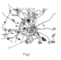
- Figure 1 shows a detail of a section of a traffic network, namely the Autobahnund Federal road network around C perfume.
- a vehicle 1 was due to its starting position (e.g. Düsseldorf) and its desired target position (for example in the south of Cologne) a first route recommended on which the vehicle 1 is initially in the example shown on the A57 from north to South, so in Figure 1 from top to bottom.
- the vehicle received navigation instructions first recommended route, for example instructions to required turning processes etc.
- the position of vehicle 1 in vehicle 1 running records what GPS (Global Positioning System) is used for has been.
- the direction of travel was also ongoing recorded, for which here several successive GPS positions were used by difference formation. The direction and position of the vehicle were continuously compared with the recommended route.
- GPS Global Positioning System
- the digital card can be in the terminal and / or in a traffic center. If the navigation in the vehicle is self-sufficient, there is a digital map and a route calculation program in the terminal in the vehicle; if the Navigation of the vehicle as here through a traffic control center position and / or Direction data from the vehicle repeatedly a traffic center is transmitted by radio, here mobile radio and in the traffic center with the one calculated there recommended route as well as data on the recommended route by mobile phone etc. from the traffic control center to a vehicle 1 for display there or creating navigation instructions for you Terminal user transmitted.
- the device (or alternatively or additionally in the traffic control center), that the vehicle is not on a recommended one Route segment belonging to a route digital map of the transport network (in the terminal and / or in the traffic center).
- vehicle 1 is to the west, i.e. in Figure 1 left, next to the A57 motorway, via which the recommended route. Therefore, there is one first Plausibility check as to whether the driver has one Had reason to leave the route.
- Traps are near your current position or in the direction of the direction of travel of the vehicle 1 no highways, federal highways etc., give way to Lead target point 2, so that it is assumed that the Vehicle 1 a local occasion, such as a Traffic jam, accident etc.
- the example in Figure 2 is based on a position of vehicle 1 on the side of the A57, that it has left the A57.
- the goal is here nearby, so that accidental turning of the Vehicle from the A57 motorway at an early stage Departure is possible, so that the plausibility check not the existence of a preferred route, which deviates from the recommended first route. For this reason, for example, a return of the Vehicle 1 recommended on the A57.
- the Vehicle 1 from the traffic center due to for example stationary and / or mobile traffic detectors an area 3 with slow traffic in Direction of travel detected on the recommended first route, so that the plausibility check shows that the Vehicle due to one caused by the driver of the vehicle of a traffic jam preferred route from the former recommended route has deviated. That's why here determined a second recommended route such that the Vehicle 1 not on the A57 and thus in traffic jam 3 is returned, but a bypass of the traffic jam 3 via secondary roads and only then a return on the A57 or by a completely new, the new route bypassing the A57 via the B59N, the A1, the E40 and the A53 are planned for goal 2.
- Procedure In addition to a route recalculation when leaving a route optimizes the invention Procedure also the first calculation of a route.
- the process can be implemented as a program in one Terminal and / or a traffic center implemented his.
- the program includes in particular in the terminal and / or a route calculation subroutine in the control center, a program unit for querying the starting position and the desired target position Sub-program for recording the vehicle position and / or the direction of travel and a program for assignment the driving position and / or driving direction to one digital card in the terminal or in the traffic center.
Landscapes
- Engineering & Computer Science (AREA)
- Radar, Positioning & Navigation (AREA)
- Remote Sensing (AREA)
- Physics & Mathematics (AREA)
- General Physics & Mathematics (AREA)
- Health & Medical Sciences (AREA)
- General Health & Medical Sciences (AREA)
- Social Psychology (AREA)
- Automation & Control Theory (AREA)
- Mathematical Physics (AREA)
- Databases & Information Systems (AREA)
- Navigation (AREA)
- Traffic Control Systems (AREA)
Description
- Fig. 1
- ein erstes Beispiel einer eine Routenneuberechnung erforderlich machenden Abweichung eines Fahrzeuges von einer ersten empfohlenen Fahrtroute durch ein Verkehrsnetz,
- Fig. 2
- ein zweites Beispiel des Abweichens eines Fahrzeuges von einer empfohlenen Fahrtroute,
- Fig. 3
- ein drittes Beispiel des Abweichens eines Fahrzeuges von einer Fahrtroute.
Claims (19)
- Verfahren zur rechnergestützten Navigation eines ein Endgerät aufweisenden Fahrzeuges in einem Verkehrsnetz unter Verwendung einer digitalen Karte des Verkehrsnetzes,
wobei am Endgerät vom Benutzer ein gewünschter Zielort abgefragt wird,
wobei eine Route zum Zielort bestimmt wird, die das bisherige Fahrverhalten berücksichtigt, wobei die Bestimmung einer Route in einer Verkehrszentrale erfolgt, wobei, wenn das Fahrzeug vor der Routenabfrage auf einer Straße höherer Kategorie langsamer gefahren ist als auf dieser Straße zu-erwarten ist, diese Straße, von welcher das Fahrzeug gerade abgebogen ist, zumindest auf einer bestimmten Strecke hinter der aktuellen Fahrzeugposition bei der Routenberechnung ausgeschlossen wird. - Verfahren nach Anspruch 1,
dadurch gekennzeichnet, dass, wenn das Fahrzeug von einer Straße auf eine Straße niedrigerer Kategorie abbiegt, die Route unter Berücksichtigung dieser Straße niedrigerer Kategorie berechnet wird. - Verfahren nach einem der vorhergehenden Ansprüche,
dadurch gekennzeichnet, dass, wenn auf der vor der Routenabfrage befahrenen Straße höherer Kategorie ein Stau oder dergleichen gemeldet wird, diese Straße bei der Routenberechnung zumindest auf einer bestimmten Strecke hinter der aktuellen Fahrzeugposition ausgeschlossen wird. - Verfahren nach einem der vorhergehenden Ansprüche,
dadurch gekennzeichnet, dass Daten zu einer empfohlenen Route von der Verkehrszentrale an das Endgerät per Funk, insbesondere Mobilfunk, übertragen werden. - Verfahren nach einem der vorhergehenden Ansprüche,
dadurch gekennzeichnet, dass zum Bestimmen der vom Fahrer bevorzugten Route oder Teilroute die Position des Fahrzeuges einem Straßenabschnitt oder dgl. in einer digitalen Karte zugeordnet wird. - Verfahren nach einem der vorhergehenden Ansprüche,
dadurch gekennzeichnet, dass Parameter der Plausibilitätsprüfung im Endgerät von einer Verkehrszentrale per Funk modifizierbar sind. - Verfahren nach einem der vorhergehenden Ansprüche,
dadurch gekennzeichnet, dass zum-Bestimmen der empfohlenen Route Verkehrsinformationen verwendet werden. - Verfahren nach einem der vorhergehenden Ansprüche,
dadurch gekennzeichnet, dass zum Bestimmen der empfohlenen Route Entfernungen in der digitalen Karte und/oder Reisezeiten oder dgl. verwendet werden. - Verfahren nach einem der vorhergehenden Ansprüche,
dadurch gekennzeichnet, dass die aktuelle Position und/oder Fahrtrichtung des Fahrzeuges mit GPS erfaßt wird. - Verfahren nach einem der vorhergehenden Ansprüche,
dadurch gekennzeichnet, dass die aktuelle Fahrtrichtung von einem Kompaß erfaßt wird. - Verfahren nach einem der vorhergehenden Ansprüche,
dadurch gekennzeichnet, dass die aktuelle Fahrtrichtung aufgrund von Lenkradeinschlägen erfaßt wird. - Verfahren nach einem der vorhergehenden Ansprüche,
dadurch gekennzeichnet, daß die aktuelle Position des Fahrzeuges aufgrund von Lenkradeinschlägen und einem Distanzmesser erfaßt wird. - Endgerät mit einem Speicher, mit einem im Speicher gespeicherten Programm zur Durchführung des Verfahrens nach einem der vorhergehenden Ansprüche oder nach Merkmalen mindestens eines der vorhergehenden Ansprüche, mit einem Prozessor zum Abarbeiten des Programms, mit einer optischen und/oder akustischen Benutzerschnittstelle und mit einer Eingabevorrichtung für zumindest eine Zielposition.
- Endgerät nach Anspruch 13,
dadurch gekennzeichnet, dass es eine Kommunikationseinrichtung zum Empfangen von Daten zu empfohlenen Routen von einer Verkehrszentrale aufweist. - Endgerät nach Anspruch 14,
dadurch gekennzeichnet, dass das Endgerät eine Mobilfunkeinrichtung aufweist. - Endgerät nach Anspruch 13, 14 oder 15,
dadurch gekennzeichnet, dass das Endgerät ein GPS-System aufweist. - Endgerät nach einem der Ansprüche 13 bis 16,
dadurch gekennzeichnet, dass das Endgerät eine digitale Karte des Verkehrsnetzes in einem Speicher aufweist. - Verkehrszentrale mit einem Speicher, mit einem im Speicher gespeicherten Programm zur Durchführung des Verfahrens nach einem der vorhergehenden Verfahrensansprüche oder nach Merkmalen mindestens eines der vorhergehenden Verfahrensansprüche, mit einem Prozessor zum Abarbeiten des Programms, mit einer digitalen Karte des Verkehrsnetzes, mit einer Kommunikationseinrichtung zum Empfangen von einen gewünschten Zielort und den aktuellen Ort eines Fahrzeuges betreffenden Daten und zum Übersenden von eine in der Verkehrszentrale erstellte Route betreffenden Daten an das Endgerät.
- Verkehrszentrale nach Anspruch 18,
dadurch gekennzeichnet, dass die Kommunikationseinrichtung eine Mobilfunkeinrichtung ist.
Applications Claiming Priority (5)
| Application Number | Priority Date | Filing Date | Title |
|---|---|---|---|
| DE1965369 | 1996-12-16 | ||
| DE19653690 | 1996-12-16 | ||
| DE19753172A DE19753172A1 (de) | 1996-12-16 | 1997-11-20 | Verfahren zur rechnergestützten Navigation eines Fahrzeuges mit einem Endgerät, Endgerät und Verkehrszentrale |
| DE1975317 | 1997-11-20 | ||
| PCT/DE1997/002816 WO1998027528A1 (de) | 1996-12-16 | 1997-11-26 | Verfahren zur rechnergestützten navigation eines fahrzeuges mit einem endgerät, endgerät und verkehrszentrale |
Publications (3)
| Publication Number | Publication Date |
|---|---|
| EP0944894A1 EP0944894A1 (de) | 1999-09-29 |
| EP0944894B1 EP0944894B1 (de) | 2000-10-11 |
| EP0944894B2 true EP0944894B2 (de) | 2004-01-14 |
Family
ID=26032621
Family Applications (1)
| Application Number | Title | Priority Date | Filing Date |
|---|---|---|---|
| EP97953604A Expired - Lifetime EP0944894B2 (de) | 1996-12-16 | 1997-11-26 | Verfahren zur rechnergestützten navigation eines fahrzeuges mit einem endgerät, endgerät und verkehrszentrale |
Country Status (4)
| Country | Link |
|---|---|
| US (1) | US6199009B1 (de) |
| EP (1) | EP0944894B2 (de) |
| ES (1) | ES2151297T5 (de) |
| WO (1) | WO1998027528A1 (de) |
Families Citing this family (17)
| Publication number | Priority date | Publication date | Assignee | Title |
|---|---|---|---|---|
| DE10010608A1 (de) * | 2000-03-03 | 2001-09-06 | Mannesmann Vdo Ag | Navigationsverfahren mit geringer Datenmenge |
| WO2002069100A2 (en) | 2001-02-26 | 2002-09-06 | Alk Technologies, Inc. | Thin-client navigation and route guidance system |
| US6604047B1 (en) | 2001-08-03 | 2003-08-05 | Scott C. Harris | Non real time traffic system for a navigator |
| US7711360B2 (en) * | 2005-11-08 | 2010-05-04 | Siemens Aktiengesellschaft | Radio frequency planning with consideration of inter-building effects |
| FI118614B (fi) * | 2005-12-27 | 2008-01-15 | Navicore Oy | Menetelmä virheiden havaitsemiseksi navigointidatassa |
| US7610151B2 (en) * | 2006-06-27 | 2009-10-27 | Microsoft Corporation | Collaborative route planning for generating personalized and context-sensitive routing recommendations |
| US8793066B2 (en) * | 2006-06-27 | 2014-07-29 | Microsoft Corporation | Route monetization |
| US20080075051A1 (en) * | 2006-09-27 | 2008-03-27 | Baris Dundar | Methods, apparatus and articles for radio frequency planning |
| DE102007019244A1 (de) * | 2007-04-24 | 2008-10-30 | Robert Bosch Gmbh | Navigationseinrichtung und Verfahren zur grafischen Darstellung von Teilgebieten mit Verkehrsbeschränkungen |
| US7692558B2 (en) * | 2007-08-01 | 2010-04-06 | Hewlett-Packard Development Company, L.P. | Apparatus, and an associated method, for forming a traffic route visualization |
| US20090112843A1 (en) * | 2007-10-29 | 2009-04-30 | International Business Machines Corporation | System and method for providing differentiated service levels for search index |
| US8428859B2 (en) * | 2007-12-14 | 2013-04-23 | Microsoft Corporation | Federated route production |
| US8473198B2 (en) | 2007-12-14 | 2013-06-25 | Microsoft Corporation | Additional content based on intended travel destination |
| US8090532B2 (en) | 2007-12-14 | 2012-01-03 | Microsoft Corporation | Pedestrian route production |
| US8060297B2 (en) | 2007-12-14 | 2011-11-15 | Microsoft Corporation | Route transfer between devices |
| US8793065B2 (en) | 2008-02-19 | 2014-07-29 | Microsoft Corporation | Route-based activity planner |
| US20130054141A1 (en) * | 2011-08-29 | 2013-02-28 | Princeton Satellite Systems | Weighted Path Selection for Mapping Route Selection |
Citations (6)
| Publication number | Priority date | Publication date | Assignee | Title |
|---|---|---|---|---|
| EP0123562B1 (de) † | 1983-04-26 | 1990-07-18 | BRITISH TELECOMMUNICATIONS public limited company | Wegbestimmungssystem für Fahrzeuge |
| DE4226230A1 (de) † | 1991-08-09 | 1993-02-18 | Mitsubishi Electric Corp | Vorrichtung zur navigation von motorfahrzeugen |
| DE4139581A1 (de) † | 1991-11-30 | 1993-06-03 | Bayerische Motoren Werke Ag | Navigationsverfahren fuer kraftfahrzeuge |
| EP0583773A2 (de) † | 1992-08-19 | 1994-02-23 | Aisin Aw Co., Ltd. | Fahrzeugnavigationssystem |
| DE4429322A1 (de) † | 1994-08-18 | 1996-02-22 | Bayerische Motoren Werke Ag | Navigationsverfahren für Kraftfahrzeuge |
| EP0702209A1 (de) † | 1994-09-14 | 1996-03-20 | Aisin Aw Co., Ltd. | Fahrzeugnavigationssystem |
Family Cites Families (7)
| Publication number | Priority date | Publication date | Assignee | Title |
|---|---|---|---|---|
| GB2271423B (en) * | 1992-10-12 | 1995-08-30 | Maspro Denko Kk | Navigation system with route determination process |
| JP3366096B2 (ja) * | 1994-02-16 | 2003-01-14 | 本田技研工業株式会社 | 車両の走行制御装置 |
| JP3059642B2 (ja) * | 1994-09-26 | 2000-07-04 | 日産ディーゼル工業株式会社 | 車両の走行経路案内装置 |
| JP3608259B2 (ja) * | 1995-07-20 | 2005-01-05 | マツダ株式会社 | 自動車の進行路推定装置 |
| US6026346A (en) * | 1996-11-27 | 2000-02-15 | Honda Giken Kogyo Kabushiki Kaisha | Navigation system for indicating of optimum route |
| US6032121A (en) * | 1997-05-15 | 2000-02-29 | International Business Machines Corporation | Method for proactive planning |
| JPH1138872A (ja) * | 1997-07-17 | 1999-02-12 | Toyota Motor Corp | 地図データ配信システム、およびそのシステムに適する地図データ取得装置 |
-
1997
- 1997-11-26 US US09/331,106 patent/US6199009B1/en not_active Expired - Lifetime
- 1997-11-26 EP EP97953604A patent/EP0944894B2/de not_active Expired - Lifetime
- 1997-11-26 ES ES97953604T patent/ES2151297T5/es not_active Expired - Lifetime
- 1997-11-26 WO PCT/DE1997/002816 patent/WO1998027528A1/de not_active Ceased
Patent Citations (6)
| Publication number | Priority date | Publication date | Assignee | Title |
|---|---|---|---|---|
| EP0123562B1 (de) † | 1983-04-26 | 1990-07-18 | BRITISH TELECOMMUNICATIONS public limited company | Wegbestimmungssystem für Fahrzeuge |
| DE4226230A1 (de) † | 1991-08-09 | 1993-02-18 | Mitsubishi Electric Corp | Vorrichtung zur navigation von motorfahrzeugen |
| DE4139581A1 (de) † | 1991-11-30 | 1993-06-03 | Bayerische Motoren Werke Ag | Navigationsverfahren fuer kraftfahrzeuge |
| EP0583773A2 (de) † | 1992-08-19 | 1994-02-23 | Aisin Aw Co., Ltd. | Fahrzeugnavigationssystem |
| DE4429322A1 (de) † | 1994-08-18 | 1996-02-22 | Bayerische Motoren Werke Ag | Navigationsverfahren für Kraftfahrzeuge |
| EP0702209A1 (de) † | 1994-09-14 | 1996-03-20 | Aisin Aw Co., Ltd. | Fahrzeugnavigationssystem |
Also Published As
| Publication number | Publication date |
|---|---|
| ES2151297T3 (es) | 2000-12-16 |
| ES2151297T5 (es) | 2004-08-16 |
| EP0944894A1 (de) | 1999-09-29 |
| WO1998027528A1 (de) | 1998-06-25 |
| US6199009B1 (en) | 2001-03-06 |
| EP0944894B1 (de) | 2000-10-11 |
Similar Documents
| Publication | Publication Date | Title |
|---|---|---|
| EP0944894B2 (de) | Verfahren zur rechnergestützten navigation eines fahrzeuges mit einem endgerät, endgerät und verkehrszentrale | |
| DE69505136T2 (de) | Transportsystem | |
| DE19716354B4 (de) | Navigationssystem für Fahrzeuge | |
| EP0958566B1 (de) | Verfahren zur übermittlung von verkehrsinformationen und vorrichtungen zum durchführen des verfahrens | |
| EP1198696B1 (de) | Verfahren und vorrichtung zur übermittlung von navigations-informationen von einer datenzentrale an ein fahrzeug-basiertes navigationssystem | |
| EP1303845B1 (de) | Verfahren zur ermittlung von verkehrslageinformationen | |
| DE102005046177A1 (de) | Fahrzeugnavigationssystem | |
| DE102016209330B4 (de) | Verfahren zum Durchführen eines kooperativen Fahrmanövers | |
| DE102017213983A1 (de) | Verfahren zum Verifizieren einer Straßenkarte sowie Servervorrichtung | |
| DE102014008151A1 (de) | Verfahren zum Betrieb eines Kraftfahrzeugs | |
| DE19519066A1 (de) | Verfahren und System zur Zielführung eines Fahrzeugs | |
| EP1017965B1 (de) | Verfahren zur aktualisierung einer digitalen strassenkarte | |
| EP3371792B1 (de) | Verfahren zum betreiben einer detektionsvorrichtung eines kraftfahrzeugs | |
| DE102021107974A1 (de) | Verfahren und Backendserver zum Koordinieren einer Einsatzfahrt eines Einsatzfahrzeugs mit anderen Kraftfahrzeugen sowie dafür ausgestattetes Kraftfahrzeug | |
| DE102011115421A1 (de) | Übertragung fahrzeugrelevanter Daten mittels Car2Car | |
| EP0884709B1 (de) | Einrichtung zur Bereitstellung von Informationen über die jeweils vorgegebene Höchstgeschwindigkeit in einem Kraftfahrzeug | |
| DE102013009856A1 (de) | Positionsbestimmung eines stationären Verkehrsobjekts mittels einer zentralen Serveranordnung | |
| EP0944895B1 (de) | Verfahren zur übertragung von eine route eines fahrzeuges in einem verkehrsnetz betreffenden routeninformationen zwischen einer verkehrszentrale und einem endgerät in einem fahrzeug, eine verkehrszentrale und ein endgerät | |
| DE102021116599A1 (de) | Verfahren zum Passieren enger Straßen | |
| EP0715289B1 (de) | Verfahren und System zur Zielführung eines Fahrzeugs | |
| EP3188948B1 (de) | Verfahren zum verarbeiten von messdaten eines fahrzeuges zur bestimmung des beginns eines parksuchverkehrs und computerprogrammprodukt | |
| WO2003107301A1 (de) | Navigationssystem für ein fahrzeug | |
| DE19753172A1 (de) | Verfahren zur rechnergestützten Navigation eines Fahrzeuges mit einem Endgerät, Endgerät und Verkehrszentrale | |
| EP2148172B1 (de) | Verfahren zum Betrieb eines Navigationssystems für ein Fahrzeug, insbesondere ein Kraftfahrzeug, und Navigationssystem | |
| DE102022001844A1 (de) | Verfahren zum Ermitteln einer Navigationsroute |
Legal Events
| Date | Code | Title | Description |
|---|---|---|---|
| PUAI | Public reference made under article 153(3) epc to a published international application that has entered the european phase |
Free format text: ORIGINAL CODE: 0009012 |
|
| 17P | Request for examination filed |
Effective date: 19990518 |
|
| AK | Designated contracting states |
Kind code of ref document: A1 Designated state(s): DE ES FR GB IT |
|
| GRAG | Despatch of communication of intention to grant |
Free format text: ORIGINAL CODE: EPIDOS AGRA |
|
| 17Q | First examination report despatched |
Effective date: 20000207 |
|
| GRAG | Despatch of communication of intention to grant |
Free format text: ORIGINAL CODE: EPIDOS AGRA |
|
| GRAH | Despatch of communication of intention to grant a patent |
Free format text: ORIGINAL CODE: EPIDOS IGRA |
|
| GRAH | Despatch of communication of intention to grant a patent |
Free format text: ORIGINAL CODE: EPIDOS IGRA |
|
| GRAA | (expected) grant |
Free format text: ORIGINAL CODE: 0009210 |
|
| AK | Designated contracting states |
Kind code of ref document: B1 Designated state(s): DE ES FR GB IT |
|
| GBT | Gb: translation of ep patent filed (gb section 77(6)(a)/1977) |
Effective date: 20001012 |
|
| REF | Corresponds to: |
Ref document number: 59702476 Country of ref document: DE Date of ref document: 20001116 |
|
| ET | Fr: translation filed | ||
| ITF | It: translation for a ep patent filed | ||
| REG | Reference to a national code |
Ref country code: ES Ref legal event code: FG2A Ref document number: 2151297 Country of ref document: ES Kind code of ref document: T3 |
|
| PLBI | Opposition filed |
Free format text: ORIGINAL CODE: 0009260 |
|
| PLBF | Reply of patent proprietor to notice(s) of opposition |
Free format text: ORIGINAL CODE: EPIDOS OBSO |
|
| 26 | Opposition filed |
Opponent name: DAIMLERCHRYSLER AG Effective date: 20010711 |
|
| REG | Reference to a national code |
Ref country code: GB Ref legal event code: IF02 |
|
| PLBF | Reply of patent proprietor to notice(s) of opposition |
Free format text: ORIGINAL CODE: EPIDOS OBSO |
|
| PLAW | Interlocutory decision in opposition |
Free format text: ORIGINAL CODE: EPIDOS IDOP |
|
| RAP2 | Party data changed (patent owner data changed or rights of a patent transferred) |
Owner name: VODAFONE HOLDING GMBH |
|
| RAP2 | Party data changed (patent owner data changed or rights of a patent transferred) |
Owner name: ATX EUROPE GMBH |
|
| PUAH | Patent maintained in amended form |
Free format text: ORIGINAL CODE: 0009272 |
|
| STAA | Information on the status of an ep patent application or granted ep patent |
Free format text: STATUS: PATENT MAINTAINED AS AMENDED |
|
| 27A | Patent maintained in amended form |
Effective date: 20040114 |
|
| AK | Designated contracting states |
Kind code of ref document: B2 Designated state(s): DE ES FR GB IT |
|
| GBTA | Gb: translation of amended ep patent filed (gb section 77(6)(b)/1977) | ||
| REG | Reference to a national code |
Ref country code: ES Ref legal event code: DC2A Date of ref document: 20040310 Kind code of ref document: T5 |
|
| ET3 | Fr: translation filed ** decision concerning opposition | ||
| PGFP | Annual fee paid to national office [announced via postgrant information from national office to epo] |
Ref country code: FR Payment date: 20041112 Year of fee payment: 8 |
|
| PGFP | Annual fee paid to national office [announced via postgrant information from national office to epo] |
Ref country code: ES Payment date: 20041117 Year of fee payment: 8 |
|
| PGFP | Annual fee paid to national office [announced via postgrant information from national office to epo] |
Ref country code: GB Payment date: 20041122 Year of fee payment: 8 |
|
| PG25 | Lapsed in a contracting state [announced via postgrant information from national office to epo] |
Ref country code: IT Free format text: LAPSE BECAUSE OF NON-PAYMENT OF DUE FEES;WARNING: LAPSES OF ITALIAN PATENTS WITH EFFECTIVE DATE BEFORE 2007 MAY HAVE OCCURRED AT ANY TIME BEFORE 2007. THE CORRECT EFFECTIVE DATE MAY BE DIFFERENT FROM THE ONE RECORDED. Effective date: 20051126 Ref country code: GB Free format text: LAPSE BECAUSE OF NON-PAYMENT OF DUE FEES Effective date: 20051126 |
|
| PG25 | Lapsed in a contracting state [announced via postgrant information from national office to epo] |
Ref country code: ES Free format text: LAPSE BECAUSE OF NON-PAYMENT OF DUE FEES Effective date: 20051128 |
|
| GBPC | Gb: european patent ceased through non-payment of renewal fee |
Effective date: 20051126 |
|
| PG25 | Lapsed in a contracting state [announced via postgrant information from national office to epo] |
Ref country code: FR Free format text: LAPSE BECAUSE OF NON-PAYMENT OF DUE FEES Effective date: 20060731 |
|
| REG | Reference to a national code |
Ref country code: FR Ref legal event code: ST Effective date: 20060731 |
|
| REG | Reference to a national code |
Ref country code: ES Ref legal event code: FD2A Effective date: 20051128 |
|
| PGFP | Annual fee paid to national office [announced via postgrant information from national office to epo] |
Ref country code: DE Payment date: 20070529 Year of fee payment: 10 |
|
| PG25 | Lapsed in a contracting state [announced via postgrant information from national office to epo] |
Ref country code: DE Free format text: LAPSE BECAUSE OF NON-PAYMENT OF DUE FEES Effective date: 20080603 |