WO2022259607A1 - 表示方法、表示制御装置、及びコンピュータプログラム - Google Patents
表示方法、表示制御装置、及びコンピュータプログラム Download PDFInfo
- Publication number
- WO2022259607A1 WO2022259607A1 PCT/JP2022/004363 JP2022004363W WO2022259607A1 WO 2022259607 A1 WO2022259607 A1 WO 2022259607A1 JP 2022004363 W JP2022004363 W JP 2022004363W WO 2022259607 A1 WO2022259607 A1 WO 2022259607A1
- Authority
- WO
- WIPO (PCT)
- Prior art keywords
- delivery
- route
- package
- vehicle
- user
- Prior art date
- Legal status (The legal status is an assumption and is not a legal conclusion. Google has not performed a legal analysis and makes no representation as to the accuracy of the status listed.)
- Ceased
Links
Images




Classifications
-
- G—PHYSICS
- G09—EDUCATION; CRYPTOGRAPHY; DISPLAY; ADVERTISING; SEALS
- G09B—EDUCATIONAL OR DEMONSTRATION APPLIANCES; APPLIANCES FOR TEACHING, OR COMMUNICATING WITH, THE BLIND, DEAF OR MUTE; MODELS; PLANETARIA; GLOBES; MAPS; DIAGRAMS
- G09B29/00—Maps; Plans; Charts; Diagrams, e.g. route diagram
- G09B29/10—Map spot or coordinate position indicators; Map reading aids
-
- B—PERFORMING OPERATIONS; TRANSPORTING
- B65—CONVEYING; PACKING; STORING; HANDLING THIN OR FILAMENTARY MATERIAL
- B65G—TRANSPORT OR STORAGE DEVICES, e.g. CONVEYORS FOR LOADING OR TIPPING, SHOP CONVEYOR SYSTEMS OR PNEUMATIC TUBE CONVEYORS
- B65G61/00—Use of pick-up or transfer devices or of manipulators for stacking or de-stacking articles not otherwise provided for
-
- G—PHYSICS
- G01—MEASURING; TESTING
- G01C—MEASURING DISTANCES, LEVELS OR BEARINGS; SURVEYING; NAVIGATION; GYROSCOPIC INSTRUMENTS; PHOTOGRAMMETRY OR VIDEOGRAMMETRY
- G01C21/00—Navigation; Navigational instruments not provided for in groups G01C1/00 - G01C19/00
- G01C21/26—Navigation; Navigational instruments not provided for in groups G01C1/00 - G01C19/00 specially adapted for navigation in a road network
- G01C21/34—Route searching; Route guidance
- G01C21/36—Input/output arrangements for on-board computers
-
- G—PHYSICS
- G06—COMPUTING OR CALCULATING; COUNTING
- G06Q—INFORMATION AND COMMUNICATION TECHNOLOGY [ICT] SPECIALLY ADAPTED FOR ADMINISTRATIVE, COMMERCIAL, FINANCIAL, MANAGERIAL OR SUPERVISORY PURPOSES; SYSTEMS OR METHODS SPECIALLY ADAPTED FOR ADMINISTRATIVE, COMMERCIAL, FINANCIAL, MANAGERIAL OR SUPERVISORY PURPOSES, NOT OTHERWISE PROVIDED FOR
- G06Q10/00—Administration; Management
- G06Q10/08—Logistics, e.g. warehousing, loading or distribution; Inventory or stock management
-
- G—PHYSICS
- G06—COMPUTING OR CALCULATING; COUNTING
- G06Q—INFORMATION AND COMMUNICATION TECHNOLOGY [ICT] SPECIALLY ADAPTED FOR ADMINISTRATIVE, COMMERCIAL, FINANCIAL, MANAGERIAL OR SUPERVISORY PURPOSES; SYSTEMS OR METHODS SPECIALLY ADAPTED FOR ADMINISTRATIVE, COMMERCIAL, FINANCIAL, MANAGERIAL OR SUPERVISORY PURPOSES, NOT OTHERWISE PROVIDED FOR
- G06Q10/00—Administration; Management
- G06Q10/08—Logistics, e.g. warehousing, loading or distribution; Inventory or stock management
- G06Q10/083—Shipping
- G06Q10/0833—Tracking
-
- G—PHYSICS
- G06—COMPUTING OR CALCULATING; COUNTING
- G06Q—INFORMATION AND COMMUNICATION TECHNOLOGY [ICT] SPECIALLY ADAPTED FOR ADMINISTRATIVE, COMMERCIAL, FINANCIAL, MANAGERIAL OR SUPERVISORY PURPOSES; SYSTEMS OR METHODS SPECIALLY ADAPTED FOR ADMINISTRATIVE, COMMERCIAL, FINANCIAL, MANAGERIAL OR SUPERVISORY PURPOSES, NOT OTHERWISE PROVIDED FOR
- G06Q10/00—Administration; Management
- G06Q10/08—Logistics, e.g. warehousing, loading or distribution; Inventory or stock management
- G06Q10/083—Shipping
- G06Q10/08355—Routing methods
-
- G—PHYSICS
- G06—COMPUTING OR CALCULATING; COUNTING
- G06Q—INFORMATION AND COMMUNICATION TECHNOLOGY [ICT] SPECIALLY ADAPTED FOR ADMINISTRATIVE, COMMERCIAL, FINANCIAL, MANAGERIAL OR SUPERVISORY PURPOSES; SYSTEMS OR METHODS SPECIALLY ADAPTED FOR ADMINISTRATIVE, COMMERCIAL, FINANCIAL, MANAGERIAL OR SUPERVISORY PURPOSES, NOT OTHERWISE PROVIDED FOR
- G06Q50/00—Information and communication technology [ICT] specially adapted for implementation of business processes of specific business sectors, e.g. utilities or tourism
- G06Q50/40—Business processes related to the transportation industry
-
- G—PHYSICS
- G09—EDUCATION; CRYPTOGRAPHY; DISPLAY; ADVERTISING; SEALS
- G09B—EDUCATIONAL OR DEMONSTRATION APPLIANCES; APPLIANCES FOR TEACHING, OR COMMUNICATING WITH, THE BLIND, DEAF OR MUTE; MODELS; PLANETARIA; GLOBES; MAPS; DIAGRAMS
- G09B29/00—Maps; Plans; Charts; Diagrams, e.g. route diagram
-
- G—PHYSICS
- G16—INFORMATION AND COMMUNICATION TECHNOLOGY [ICT] SPECIALLY ADAPTED FOR SPECIFIC APPLICATION FIELDS
- G16Y—INFORMATION AND COMMUNICATION TECHNOLOGY SPECIALLY ADAPTED FOR THE INTERNET OF THINGS [IoT]
- G16Y10/00—Economic sectors
- G16Y10/40—Transportation
-
- G—PHYSICS
- G16—INFORMATION AND COMMUNICATION TECHNOLOGY [ICT] SPECIALLY ADAPTED FOR SPECIFIC APPLICATION FIELDS
- G16Y—INFORMATION AND COMMUNICATION TECHNOLOGY SPECIALLY ADAPTED FOR THE INTERNET OF THINGS [IoT]
- G16Y20/00—Information sensed or collected by the things
- G16Y20/20—Information sensed or collected by the things relating to the thing itself
-
- G—PHYSICS
- G16—INFORMATION AND COMMUNICATION TECHNOLOGY [ICT] SPECIALLY ADAPTED FOR SPECIFIC APPLICATION FIELDS
- G16Y—INFORMATION AND COMMUNICATION TECHNOLOGY SPECIALLY ADAPTED FOR THE INTERNET OF THINGS [IoT]
- G16Y40/00—IoT characterised by the purpose of the information processing
- G16Y40/60—Positioning; Navigation
Definitions
- the present disclosure relates to display methods, display control devices, and computer programs.
- This application claims priority based on Japanese application No. 2021-097082 filed on June 10, 2021, and incorporates all the descriptions described in the Japanese application.
- joint delivery in which packages collected from multiple shippers are mixed on the same delivery vehicle and delivered to multiple receivers.
- consolidated delivery vehicles deliver packages via various points, so there is a demand from the delivery requester (shipper or receiver) to check the delivery status of the package.
- Patent Document 1 in order to prevent a predetermined point such as a user's home or place of work from being known, the vicinity of the predetermined point is displayed with a circle, or the route to the predetermined point is displayed in the vicinity of the predetermined point.
- An information processing system is disclosed that changes and displays a route to an intersection.
- a display method is a display method for displaying a delivery status of a related package, which is a package related to the user, on a terminal device used by a user, and includes a display method for displaying a delivery status of a related package, which is a package related to the user.
- An abstracted route that is a route excluding the delivery destination of unrelated packages that are packages that are not related to the user, and an icon indicating a position on the abstracted route corresponding to the position of the vehicle on the delivery route of the related packages. and causing the terminal device to display a map on which .
- a display control device is a display control device that causes a terminal device used by a user to display the delivery status of a related package, which is a package related to the user.
- a route information acquisition unit that acquires route information of a delivery route; a position information acquisition unit that acquires position information of the vehicle; an abstract route that is a route and is a route excluding delivery destinations of unrelated packages that are not related to the user among the target packages; and the abstract route that corresponds to the position of the vehicle on the delivery route of the related packages.
- a display control unit that causes the terminal device to display a map superimposed with an icon indicating the upper position.
- a computer program is a computer program for causing a computer to function as a display control device that displays the delivery status of a related package, which is a package related to the user, on a terminal device used by the user.
- a route information acquiring unit for acquiring route information of a delivery route of a target package to be delivered by a vehicle;
- a position information acquiring unit for acquiring position information of the vehicle;
- an abstracted route which is a route from the delivery source to the delivery destination of the related package and excludes the delivery destination of the unrelated package that is not related to the user among the target packages;
- It functions as a display control unit that causes the terminal device to display a map superimposed with an icon indicating the position on the abstracted route corresponding to the position of the vehicle on the package delivery route.
- the present disclosure can also be implemented as a computer program for causing a computer to execute characteristic steps included in the display method. It goes without saying that such a computer program can be distributed via a computer-readable non-temporary recording medium such as a CD-ROM (Compact Disc-Read Only Memory) or a communication network such as the Internet. stomach.
- a computer-readable non-temporary recording medium such as a CD-ROM (Compact Disc-Read Only Memory) or a communication network such as the Internet. stomach.
- FIG. 1 is a diagram for explaining an example of a joint delivery mechanism.
- FIG. 2 is a diagram showing an overall configuration of a joint delivery system, a joint delivery management system, or an information system used in the joint delivery system according to Embodiment 1 of the present disclosure.
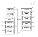
- FIG. 3 is a diagram illustrating an example of a configuration of a display control device according to Embodiment 1 of the present disclosure;
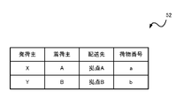
- FIG. 4 is a diagram showing an example of route information.
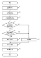
- FIG. 5 is a flowchart illustrating an example of a processing procedure of the display control device;
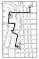
- FIG. 6 is a diagram showing the delivery route of the delivery vehicle indicated by the route information displayed on the map indicated by the map information.
- FIG. 1 is a diagram for explaining an example of a joint delivery mechanism.
- FIG. 2 is a diagram showing an overall configuration of a joint delivery system, a joint delivery management system, or an information system used in the joint delivery system according to Embodiment 1 of the present disclosure.
- FIG. 3 is a diagram
- FIG. 7 is a diagram showing an example of display data displayed on the display screens of terminal devices used by shipper Y and receiver B.
- FIG. 8 is a diagram showing an example of display data generated in the display data display process (step S9 in FIG. 5).
- FIG. 9 is a diagram showing an example of display data generated in the display data display process (step S9 in FIG. 5).
- FIG. 10 is a diagram showing an example of display data generated in the display data display process (step S9 in FIG. 5).
- FIG. 11 is a diagram showing an example of display data displayed on the display screen of the terminal device used by the shipper Y and the shipper B.
- FIG. FIG. 12 is a diagram showing an example of display data displayed on the display screen of the terminal device used by the sender Y and the receiver B.
- FIG. 8 is a diagram showing an example of display data generated in the display data display process (step S9 in FIG. 5).
- FIG. 9 is a diagram showing an example of display data generated in the display data display process (step
- the delivery destination may be analogized by others.
- the present disclosure has been made in view of such circumstances.
- the object is to provide an apparatus and a computer program.
- a display method is a display method for displaying the delivery status of a related package, which is a package related to the user, on a terminal device used by the user.
- the abstracted route does not include the delivery destination of unrelated packages, so the delivery destinations of unrelated packages are not displayed on the map. Therefore, the delivery routes of unrelated parcels are not known to the user. Also, an icon is displayed at a position on the abstracted route corresponding to the position of the vehicle on the delivery route. Therefore, the user can grasp the rough position of the vehicle and check the delivery status. Therefore, the delivery status of the related packages can be displayed to the user naturally without letting the users, who are the other senders and receivers, know the delivery routes of the unrelated packages.
- the abstract route may be a straight line or a curved line connecting the delivery source and delivery destination of the related package.
- the abstract route may be an area based on the distance or time of arrival from the delivery source or delivery destination of the related package.
- an icon indicating the position of the vehicle on the delivery route of the related package may be superimposed on the map in the vicinity of the delivery destination of the related package.
- the user can know the exact location of the vehicle when the related package approaches the delivery destination.
- the display method further includes a step of acquiring information on the congested section occurring on the delivery route, and the step of displaying further includes the abstraction of the congested section information based on the congested section information.
- Congestion sections may be superimposed and displayed on the route.
- the congested section is displayed on the abstracted route, so the user can easily know whether the vehicle is in the congested section by looking at the icon.
- a corresponding line corresponding to the delivery route of the related parcel and an icon indicating a position on the corresponding line corresponding to the position of the vehicle on the delivery route are displayed. It may be displayed on the terminal device.
- the user can intuitively grasp the degree of progress of delivery by the vehicle by looking at the correspondence line and the icons on the correspondence line.
- remaining information regarding the remaining distance or remaining time to the delivery destination of the related package may be displayed on the terminal device.
- the user can check the remaining information related to the remaining distance or remaining time to the delivery destination.
- the delivery route and an icon indicating the position of the vehicle on the delivery route are displayed. may be superimposed on the map.
- the user can confirm the exact delivery route from the delivery source to the delivery destination and the location of the vehicle.
- the user may be a shipper of a package, and the related package may be a package delivered by the shipper.
- the user may be a consignee of a package, and the related package may be a package delivered to the consignee.
- the user may be an administrator of the vehicle, and the related package may be a package delivered by the vehicle.
- the display method further includes displaying the abstracted route when the unrelated package exists in the middle of the delivery route and the position of the vehicle is not in the vicinity of the delivery destination of the related package. It may include a step of asking.
- the delivery status of the related packages can be displayed to the user naturally without letting the users, who are the other senders and receivers, know the delivery routes of the unrelated packages.
- a display control device is a display control device that causes a terminal device used by a user to display the delivery status of a related package, which is a package related to the user.
- a route information acquisition unit that acquires route information of a delivery route of a target parcel, a position information acquisition unit that acquires position information of the vehicle, and a delivery source of the related parcel based on the route information and the position information;
- An abstract route that is a route to a delivery destination and is a route excluding delivery destinations of non-related packages that are not related to the user among the target packages, and a position of the vehicle on the delivery route of the related packages.
- a display control unit that causes the terminal device to display a map superimposed with an icon indicating a position on the abstracted route.
- This configuration includes processing units corresponding to the characteristic steps in the display method described above. Therefore, according to this configuration, the same actions and effects as those of the display method described above can be obtained.
- a computer program causes a computer to function as a display control device that displays the delivery status of a related package, which is a package related to the user, on a terminal device used by the user.
- a computer program comprising: a route information obtaining unit for obtaining route information of a delivery route of a target package to be delivered by a vehicle; a position information obtaining unit for obtaining position information of the vehicle; and the route information and the An abstracted route that is a route from the delivery source to the delivery destination of the related package based on the position information, and is a route excluding the delivery destination of the unrelated package that is not related to the user among the target packages. and an icon indicating the position on the abstract route corresponding to the position of the vehicle on the delivery route of the related parcel are superimposed on the terminal device.
- the computer can function as the display control device described above. Therefore, it is possible to obtain the same actions and effects as those of the display control device described above.
- Embodiment 1 a parcel delivery system using joint delivery will be described.
- FIG. 1 is a diagram for explaining an example of a joint delivery mechanism.
- Joint delivery is a mechanism in which a plurality of parcels requested to be delivered by a plurality of consignors are mixed on the same vehicle and delivered to the delivery destination of each consignee.
- sender X requests receiver A located at base A to deliver package a.
- shipper Y requests the receiver B located at the base B to deliver the package b.
- Packages a and b are collected from shippers X and Y to the distribution center, respectively.
- the collection may be performed by a vehicle managed by the distribution center, or by a vehicle managed by the shippers X and Y.
- the delivery vehicle 7 mixes the packages a and b to be delivered at the delivery center, moves from the delivery center to the base A, and delivers the package a to the receiver A at the base A. After that, the delivery vehicle 7 moves from the base A to the base B, and delivers the package b to the consignee B at the base B.
- FIG. 2 is a diagram illustrating an overall configuration of a joint delivery system, a joint delivery management system, or an information system used in the joint delivery system according to Embodiment 1 of the present disclosure.
- joint delivery system 1 is a system for managing joint delivery of parcels, and includes sender terminals 2X and 2Y, receiver terminals 3A and 3B, display control device 4, and administrator terminal 5. , a traffic information providing device 6 , and a delivery vehicle 7 .
- the joint delivery system 1 shown in FIG. 2 may be a joint delivery management system or an information system used in the joint delivery system.
- Shipper terminals 2X and 2Y are terminal devices used by shippers X and Y shown in FIG.
- Receiver terminals 3A and 3B are terminal devices used by receivers A and B shown in FIG.
- the administrator terminal 5 is a terminal device used by an administrator of the package delivery vehicle 7, an administrator of packages delivered by the delivery vehicle 7, or an administrator of the joint delivery system.
- the display control device 4 controls the display screens of the sender terminals 2X and 2Y, the display screens of the receiver terminals 3A and 3B, and the display screen of the administrator terminal 5 to display the delivery status of the packages.
- the traffic information providing device 6 provides congested section information indicating congested sections occurring on the road.
- the delivery vehicle 7 is a vehicle such as a truck or a van that consolidates packages for multiple receivers and delivers them to each receiver. For example, the delivery vehicle 7 mixes the packages a and b and delivers them to the consignees A and B.
- the delivery vehicle 7 includes a locating unit for locating the delivery vehicle 7 .
- the locating unit locates the delivery vehicle 7 using satellite navigation. For example, the positioning unit identifies the position of the delivery vehicle 7 based on radio waves received from multiple GPS (Global Positioning System) satellites.
- GPS Global Positioning System
- the position of the delivery vehicle 7 can be identified by, for example, latitude and longitude. Satellite navigation uses a satellite positioning system (GNSS: Global Navigation Satellite System) such as GPS, but is not limited to GPS.
- GNSS Global Navigation Satellite System
- the locating unit may be, for example, a smart phone, a tablet terminal, or the like.
- the sender terminals 2X and 2Y, the receiver terminals 3A and 3B, the display control device 4, the administrator terminal 5, the traffic information providing device 6, and the delivery vehicle 7 are connected to a network 8 such as the Internet by wire or wirelessly, and are mutually connected. can send and receive data to a network 8 such as the Internet by wire or wirelessly, and are mutually connected. can send and receive data to a network 8 such as the Internet by wire or wirelessly, and are mutually connected. can send and receive data to
- FIG. 3 is a diagram showing an example of the configuration of the display control device 4 according to Embodiment 1 of the present disclosure.
- the display control device 4 is configured by a computer and includes a communication I/F (interface) section 40, an input/output I/F section 41, a memory 42, and a processor 43, which are interconnected via a bus 44.
- the communication I/F unit 40 includes a communication module for performing wired or wireless communication with an external device.
- the input/output I/F unit 41 includes an interface for connecting an input device such as a keyboard and mouse, an output device such as a display device, and the display control device 4 .
- the memory 42 is a volatile memory element such as SRAM (Static RAM) or DRAM (Dynamic RAM), a non-volatile memory element such as flash memory or EEPROM (Electrically Erasable Programmable Read Only Memory), or a magnetic storage such as a hard disk. It is composed of devices and the like.
- Memory 42 stores a computer program 53 executed by processor 43 .
- the memory 42 also stores map information 51 and route information 52 that are used when the computer program 53 is executed.
- memory 42 stores data generated when computer program 53 is executed.
- FIG. 4 is a diagram showing an example of the route information 52.
- the route information 52 includes information on the sender, the receiver, the delivery destination, and the package number.
- the delivery vehicle 7 delivers the consolidated cargo according to the route information 52 . Note that the delivery vehicle 7 sequentially processes the route information 52 from the top row. In other words, in the route information 52, after the package (package a) from the sender X to the receiver A with the package number a is delivered to the base A, the package with the package number b from the sender Y to the receiver B (package b) to location B is shown.
- the delivery destination information includes location information of the delivery destination.
- the processor 43 is configured by a CPU (Central Processing Unit) or the like, and functions as a functional processing unit implemented by executing a computer program 53 stored in the memory 42 to acquire route information. It includes a unit 54 , a position information acquisition unit 55 , a congestion section information acquisition unit 56 , and a display control unit 57 .
- CPU Central Processing Unit
- the route information acquisition unit 54 acquires the route information 52 by reading the route information 52 of the delivery route from the memory 42 . Note that when the route information 52 is stored in the external device, the route information acquisition unit 54 may receive the route information 52 from the external device via the communication I/F unit 40 .
- the position information acquisition unit 55 acquires the position information of the delivery vehicle 7 by receiving the position information of the delivery vehicle 7 from the delivery vehicle 7 via the communication I/F unit 40 .
- the position information acquisition unit 55 may receive the position information of the delivery vehicle 7 not directly from the delivery vehicle 7 but from another device.
- Another device may be, for example, a smart phone, a tablet terminal, or the like.
- the congested section information acquisition unit 56 acquires congested section information by receiving the congested section information from the traffic information providing device 6 via the communication I/F unit 40 .
- the display control unit 57 controls the map information 51 stored in the memory 42, the route information 52 acquired by the route information acquisition unit 54, the position information of the delivery vehicle 7 acquired by the position information acquisition unit 55, and the traffic congestion section information acquisition unit 56.
- Display control unit 57 causes the display data to be displayed on the display screen of each terminal by transmitting the generated display data to each terminal via communication I/F unit 40 .
- FIG. 5 is a flow chart showing an example of a processing procedure of the display control device 4. As shown in FIG. The processing shown in FIG. ), and is executed for each user. As a result, a different display screen (see FIGS. 7 to 12) is displayed for each terminal used by the user.
- route information acquisition unit 54 reads route information 52 from memory 42 (step S1).
- FIG. 6 is a diagram showing the delivery route of the delivery vehicle 7 indicated by the route information 52 on the map indicated by the map information 51.
- a map 60 shows a delivery route 61 from a delivery center to a base A and from the base A to a base B.
- a delivery route 61 may be displayed on the administrator terminal 5 as shown in FIG. Using FIG. 6 as an example, the processing procedure of FIG. 5 will be described.
- the position information acquisition unit 55 receives the position information of the delivery vehicle 7 from the delivery vehicle 7 via the communication I/F unit 40 (step S2).
- the congestion section information acquisition unit 56 receives the congestion section information from the traffic information providing device 6 via the communication I/F unit 40 (step S3).
- the display control unit 57 determines whether or not there is a delivery destination for an unrelated package (described later) in the middle of the delivery route 61 for the related package (described later) (step S4).
- a related package indicates a package related to a user, and indicates a package shipped from the user when the user is the shipper, and indicates a package delivered to the user when the user is the receiver.
- the related cargo for sender X and receiver A is package a
- the related package for sender Y and receiver B is package b.
- the package to be delivered by the delivery vehicle 7 is shown.
- the related packages for the manager of the delivery vehicle 7 are packages a and b.
- Unrelated packages are packages that are not related to the user.
- the non-related packages are the packages to be delivered by the delivery vehicle 7 excluding the related packages.
- the unrelated cargo for shipper X and receiver A is cargo b
- the unrelated cargo for shipper Y and receiver B is cargo a.
- the delivery route 61 of related package b (delivery route 61 from the distribution center to base B) includes a base A, which is the delivery destination of unrelated package a. exists (YES in step S4), the display control unit 57 shifts the process to step S5.
- step S5 the display control unit 57 determines whether the position of the delivery vehicle 7 is near the delivery destination of the related package (step S5).
- the display control unit 57 may set a location within a predetermined distance from the delivery destination as the vicinity of the delivery destination, or may set a position that can be reached within a predetermined time from the delivery destination as the vicinity of the delivery destination.
- step S5 When the delivery vehicle 7 is located near the delivery destination of the related package (YES in step S5), the display control unit 57 transitions to step S9.
- step S5 If the delivery vehicle 7 is not located near the delivery destination of the related package (NO in step S5), the display control unit 57 transitions to step S6.
- step S6 the display control unit 57 generates display data abstracting the delivery route of the delivery vehicle 7, and transmits the display data to the terminals used by the user (here, the sender terminal 2Y and the receiver terminal 3B). By doing so, the display data is displayed on the terminal (step S6).
- the display control unit 57 displays an abstract route (described later) when there is an unrelated package in the middle of the delivery route of the delivery vehicle 7 and the position of the delivery vehicle 7 is not near the delivery destination of the related package. and generate display data containing the abstracted paths.
- the display control unit 57 generates display data as follows.
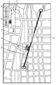
- FIG. 7 is a diagram showing an example of display data displayed on the display screen of the terminal devices used by shipper Y and receiver B (shipper terminal 2Y and receiver terminal 3B).
- the display control unit 57 Based on the route information and the position information, the display control unit 57 generates display data in which an abstracted route 62 (to be described later) and an icon 63 indicating the position of the delivery vehicle 7 are superimposed on the map 60 indicated by the map information 51. do.
- the abstract route 62 is the route from the delivery source (distribution center) of the related package b to the delivery destination (base B), and is an abstracted route excluding the base A, which is the delivery destination of the unrelated package a. It is.
- the abstract route 62 is a route connecting the delivery source and the delivery destination with a straight line.
- the abstracted route 62 is a route that hides the detailed route from the delivery source to the delivery destination, and indicates a route on which the delivery vehicle 7 does not travel (for example, a route that passes points other than roads).
- the icon 63 is arranged at a position on the abstract route 62 corresponding to the position of the delivery vehicle 7 on the delivery route 61 of the related package b.
- the icon 63 is placed at a position 30% from the distribution center of the abstracted route 62 .
- the location of the distribution center is 0% from the distribution center
- the location of base B is 100% from the distribution center.
- the display control unit 57 displays the congested section 64 on the abstracted route 62 based on the congested section information acquisition unit 56 .
- the congested section 64 is displayed in a manner distinguishable from other sections (for example, in a different color or hatching from other sections).
- the display control unit 57 After displaying the display data, the display control unit 57 generates a chart 70 simply showing the delivery route of the related parcel, and transmits the data of the chart to the terminal used by the user.
- the chart 70 is displayed (step S7).
- the chart 70 includes a correspondence line 71 corresponding to the delivery route 61 of the related package and an icon 72 on the correspondence line 71.
- the correspondence line 71 is a straight line showing the route from the delivery source to the delivery destination of the target parcel.
- the icon 72 is arranged at a position on the correspondence line 71 corresponding to the position of the delivery vehicle 7 on the delivery route 61 of the related package b.
- the icon 72 is arranged at a position 30% from the distribution center of the correspondence line 71.
- the location of the distribution center is 0% from the distribution center
- the location of base B is 100% from the distribution center.
- the chart 70 may be arranged on the map 60 as shown in FIG. 7, or may be arranged outside the map 60.
- the display control unit 57 After displaying the chart 70, the display control unit 57 generates remaining information 80 regarding the remaining distance or remaining time to the delivery destination of the related parcel, and transmits the remaining information 80 to the terminal of the user.
- the remaining information 80 is displayed (step S8).
- the remaining information 80 indicates the ratio of the remaining distance to the delivery destination of the related package b. For example, if the ratio of the distance (distance) from the position of the delivery vehicle 7 to base B to the distance (distance) from the distribution center to base B is 70%, then "Currently delivering: 70% remaining until arrival". and residual information 80 is generated.
- the remaining information 80 may include the remaining distance or remaining time to the base B, which is the delivery destination of the related package b.
- the residual information 80 may also include the ratio of the estimated travel time (remaining time) from the position of the delivery vehicle 7 to the base B with respect to the estimated travel time from the distribution center to the base B.
- the display control device 4 updates the data displayed on each terminal by repeating the process shown in FIG. 5 at predetermined time intervals.
- the display data is displayed on the terminal (step S9).
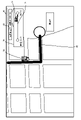
- FIG. 8 is a diagram showing an example of display data generated in the display data display process (step S9 in FIG. 5).
- the display control unit 57 Based on the route information and the position information, the display control unit 57 generates display data in which the delivery route 65 of the related package and the icon 63 indicating the position of the delivery vehicle 7 are superimposed on the map 60 indicated by the map information 51. do.
- a delivery route 65 indicates the route on the map 60 that the delivery vehicle 7 is actually scheduled to travel, and an icon 63 indicates the actual position of the delivery vehicle 7 on the delivery route 65 .
- step S7 in FIG. 5 the chart display process (step S7 in FIG. 5) and the remaining information display process (step S8 in FIG. 5) are executed.
- a chart 70 is displayed in the chart display process, and residual information 80 is displayed in the residual information display process.
- step S4 the display control unit 57 always transitions to step S9.
- the display control unit 57 always transitions to step S9 because there is no non-related package in the first place (NO in step S4). .
- step S9 the display control device 4 generates display data in which an icon indicating the position of the delivery vehicle 7 on the delivery route of the delivery vehicle 7 is superimposed on the map, and displays the display data on the terminal used by the user (here, the shipper By transmitting to the terminal 2X, the receiver terminal 3A, and the manager terminal 5), the display data is displayed on the terminal.
- FIG. 9 is a diagram showing an example of display data generated in the display data display process (step S9 in FIG. 5).
- FIG. 9 shows, as an example, display data displayed on the display screens of the sender terminal 2X and the receiver terminal 3A.
- the display control unit 57 displays a delivery route 65 to the delivery destination (here, base A) of the related package and the position of the delivery vehicle 7 on the map 60 indicated by the map information 51.
- the display data superimposed with the icon 63 shown is generated.
- a delivery route 65 indicates the route on the map 60 that the delivery vehicle 7 is actually scheduled to travel, and an icon 63 indicates the actual position of the delivery vehicle 7 on the delivery route 65 .
- the display data does not include the delivery route from the base A to the delivery destination of the non-related package (here, the base B). As a result, the status of delivery to base B can be hidden from shipper X and receiver A.
- FIG. 10 is a diagram showing an example of display data generated in the display data display process (step S9 in FIG. 5).
- FIG. 10 shows display data displayed on the display screen of the administrator terminal 5 as an example.
- the display control unit 57 displays a delivery route 65 to the delivery destination of the related package (here, base A and base B) and the delivery vehicle 7 on the map 60 indicated by the map information 51.
- display data superimposed with an icon 63 indicating the position of .
- a delivery route 65 indicates the route on the map 60 that the delivery vehicle 7 is actually scheduled to travel, and an icon 63 indicates the actual position of the delivery vehicle 7 on the delivery route 65 .
- the display data includes the delivery routes to the delivery destinations (base A and base B) of the related packages (packages a and b) for the manager of the delivery vehicle 7, and the packages not to be delivered by the delivery vehicle 7. It does not include the delivery route to the delivery destination.
- the delivery route of the package other than the package to be delivered by the delivery vehicle 7 that is, the delivery by the vehicle managed by another manager different from the manager of the delivery vehicle 7. It is possible to hide the delivery route of the delivered package.
- the abstracted route 62 shown in FIG. 7 does not include the delivery destination of the unrelated package a. is not displayed. Therefore, the delivery route of the unrelated package a is not known to the users (shipper Y and receiver B). Also, an icon 63 is displayed at a position on the abstracted route 62 corresponding to the position of the delivery vehicle 7 on the delivery route 61 shown in FIG. Therefore, the user can roughly grasp the position of the delivery vehicle 7 and can confirm the delivery status of the related package b. Therefore, the delivery status of the related cargo b can be naturally displayed to the user without letting the users, who are the other consignors and other consignees, know the delivery route of the unrelated cargo a.
- the abstracted route 62 is a straight line that connects the delivery source and delivery destination of the related package b. Therefore, the icon 63 corresponding to the position of the delivery vehicle 7 can be displayed on the straight line, and the user can intuitively grasp the rough position of the delivery vehicle 7, the remaining distance to the delivery destination, and the like. can be done.
- the chart 70 includes a corresponding line 71 of the delivery route 61 of the related package b, and an icon 72 indicating the position on the corresponding line 71 corresponding to the position of the delivery vehicle 7 on the delivery route 61. including. Therefore, by looking at the correspondence line 71 and the icons 72 on the correspondence line 71 , the user can intuitively grasp the progress of delivery of the related package b by the delivery vehicle 7 .
- residual information 80 is displayed. This allows the user to check the remaining distance or remaining time to the delivery destination.
- a delivery route 65 of the related package a and an icon 63 indicating the position of the delivery vehicle 7 on the delivery route 65 are superimposed on the map 60 as shown in FIG. be done. For this reason, if there is no waypoint such as a competing company on the delivery route 65 of the related package a, the user (shipper X and receiver A) can determine the correct delivery route 65 and The position of the delivery vehicle 7 can be confirmed.
- the related package is the package delivered by the shipper. Therefore, it is possible to prevent the shipper of the package from seeing the delivery route of the package other than the package to be delivered from the shipper.
- the related package is the package delivered to the receiver. For this reason, it is possible to prevent the delivery route of packages other than packages to be delivered to the receiver of the package from being shown to the receiver of the package.
- the related package is the package delivered by the delivery vehicle 7 . Therefore, for the manager of the delivery vehicle 7, the delivery route for the package other than the package to be delivered by the delivery vehicle 7, that is, the delivery by the vehicle managed by another manager different from the manager of the delivery vehicle 7. It is possible to hide the delivery route of the delivered package.
- the delivery status of the related packages can be displayed to the user naturally without letting the users, who are the other senders and receivers, know the delivery routes of the unrelated packages.
- the abstract path 62 is indicated by straight lines as shown in FIG.
- the abstract path 62 is not limited to straight lines.
- an example in which abstract paths are indicated by curved lines will be described.
- the configuration of the joint delivery system 1 is the same as that of the first embodiment. Therefore, its detailed description will not be repeated here.
- the display data generation method by the display control unit 57 is different from that of the first embodiment. That is, the display control unit 57 generates display data as follows.
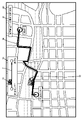
- FIG. 11 is a diagram showing an example of display data displayed on the display screen of the terminal device used by shipper Y and receiver B.
- the display control unit 57 generates display data in which a curved abstract route 66 is superimposed on the map 60 instead of the straight line abstract route 62 shown in FIG.
- the display control unit 57 does not generate the abstracted route 67 that passes through an area such as a river 68 where the delivery vehicle 7 cannot travel, but creates an area such as the ground where the delivery vehicle 7 can travel. Generate an abstract path 66 to pass through.
- the display control unit 57 superimposes an icon 63 indicating the position of the delivery vehicle 7 on the abstracted route 66 .
- the icon 63 is arranged at a position on the abstract route 66 corresponding to the position of the delivery vehicle 7 on the delivery route 61 of the related package b. For example, in the delivery route 61 shown in FIG. , the icon 63 is placed 30% from the distribution center of the abstracted route 66 .
- the display control unit 57 displays the congested section 64 on the abstracted route 66 based on the congested section information acquisition unit 56 . For example, in the delivery route 61 shown in FIG. 57 places a congested section 64 on the section of the abstracted route 66 from 40% to 60% from the distribution center.
- the delivery status of the related package b can be presented to the user without making the user feel uncomfortable.
- the abstract path 62 is indicated by straight lines as shown in FIG. 7, and in the second embodiment, the abstract path 66 is indicated by curved lines as shown in FIG.
- abstract paths are not limited to lines.
- an example in which an abstracted path is indicated by an area will be described.
- the configuration of the joint delivery system 1 is the same as that of the first embodiment. Therefore, its detailed description will not be repeated here.
- the display data generation method by the display control unit 57 is different from that of the first embodiment. That is, the display control unit 57 generates display data as follows.
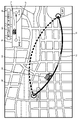
- FIG. 12 is a diagram showing an example of display data displayed on the display screen of the terminal device used by sender Y and receiver B.
- the display control unit 57 generates display data in which an abstracted route composed of areas 69A to 69C is superimposed on the map 60 instead of the linear abstracted route 62 shown in FIG.
- regions 69A to 69C will be referred to as regions 69 when not distinguished.
- each area 69 is an area based on the reachable distance from the delivery source of the related package b.
- area 69A indicates an area whose distance from the distribution center is greater than or equal to a and less than b.
- a region 69B indicates a region where the distance from the distribution center is greater than or equal to b and less than c.
- a region 69C indicates a region whose distance from the distribution center is greater than or equal to c and less than d.
- a ⁇ b ⁇ c ⁇ d Each area is displayed in a different manner (eg, different color, hatching, etc.) to distinguish it from other adjacent areas.
- the area 69B is an area including a congested section, and is displayed in a manner (for example, red) that indicates that the congested section is included. In other words, it indicates that the traffic jam occurs in the range where the distance from the distribution center is greater than or equal to b and less than or equal to c.
- the display control unit 57 arranges the icon 63 on the straight line 90 connecting the distribution center and the base B, which is the delivery destination of the related package b, on the map 60 .
- the icon 63 is arranged at a position on a straight line 90 corresponding to the position of the delivery vehicle 7 on the delivery route 61 of the related package b shown in FIG. For example, in the delivery route 61, if the ratio of the distance from the delivery center to the position of the delivery vehicle 7 to the distance from the delivery center to the base B is 30%, the display control unit 57 displays the straight line 90 as the delivery route.
- An icon 63 is arranged at a position 30% from the center.
- the user can intuitively grasp the reachable distance of the delivery vehicle 7 from the delivery source of the related package b. can.
- each area 69 is not limited to an area based on the reachable distance from the delivery source (distribution center) of the related package b.
- each area 69 may be an area based on the reachable distance from the delivery destination (location B) of the related package b.
- each area 69 indicates an area within a predetermined range of the same reaching distance from the base B.
- FIG. Note that the reachable distance ranges of the regions 69A to 69C are set so as not to overlap. This allows the user to intuitively grasp the reachable distance from the delivery vehicle 7 to the delivery destination of the related package b.
- each area 69 may be an area based on the arrival time from the delivery source (distribution center) of the related package b.
- each area 69 indicates an area whose arrival time from the distribution center is within the same predetermined range.
- the arrival time ranges of the regions 69A to 69C are set so as not to overlap.
- area 69A indicates a reachable range of 20 minutes or more and less than 40 minutes from the distribution center.
- a region 69B indicates a reachable range within 40 minutes or more and less than 60 minutes from the distribution center.
- a region 69C indicates a reachable range within 60 minutes or more and less than 80 minutes from the distribution center.
- each area 69 may be an area based on the arrival time from the delivery destination (location B) of the related package b.
- each area 69 indicates an area in which the arrival time from the base B is within the same predetermined range. Note that the arrival time ranges of the regions 69A to 69C are set so as not to overlap.
- Each process (each function) of the above-described embodiment is realized by a processing circuit (circuitry) including one or more processors.
- the processing circuit may be configured by an integrated circuit or the like in which one or more memories, various analog circuits, and various digital circuits are combined in addition to the one or more processors.
- the one or more memories store programs (instructions) that cause the one or more processors to execute the processes.
- the one or more processors may execute the processes according to the program read from the one or more memories, or execute the processes according to a logic circuit designed in advance to execute the processes. may be executed.
- the above processor is a CPU (Central Processing Unit), a GPU (Graphics Processing Unit), a DSP (Digital Signal Processor), an FPGA (Field Programmable Gate Array), an ASIC (Application Specific Integrated Circuit compatible with various computer controls, etc.) It can be a processor.
- the plurality of physically separated processors may cooperate with each other to execute the above processes.
- the processors installed in each of a plurality of physically separated computers cooperate with each other via networks such as LAN (Local Area Network), WAN (Wide Area Network), and the Internet to execute the above processes.
- LAN Local Area Network
- WAN Wide Area Network
- the computer program described above may be recorded on a computer-readable non-temporary recording medium, such as a HDD (Hard Disk Drive), a CD-ROM (Compact Disc-Read Only Memory), a semiconductor memory, etc., and distributed. good too.
- the computer program may be transmitted and distributed via an electric communication line, a wireless or wired communication line, a network represented by the Internet, data broadcasting, or the like.
- part or all of the functions of the above devices may be provided by cloud computing. That is, part or all of the functions of each device may be realized by the cloud server. Furthermore, at least part of the above embodiments may be combined arbitrarily.
- Joint delivery system joint delivery management system, information system used in the joint delivery system
Landscapes
- Engineering & Computer Science (AREA)
- Business, Economics & Management (AREA)
- Physics & Mathematics (AREA)
- Economics (AREA)
- Theoretical Computer Science (AREA)
- General Physics & Mathematics (AREA)
- General Business, Economics & Management (AREA)
- Tourism & Hospitality (AREA)
- Strategic Management (AREA)
- Human Resources & Organizations (AREA)
- Marketing (AREA)
- Development Economics (AREA)
- Operations Research (AREA)
- Quality & Reliability (AREA)
- Entrepreneurship & Innovation (AREA)
- Radar, Positioning & Navigation (AREA)
- Remote Sensing (AREA)
- Educational Technology (AREA)
- Educational Administration (AREA)
- Mathematical Physics (AREA)
- Computing Systems (AREA)
- Primary Health Care (AREA)
- General Health & Medical Sciences (AREA)
- Health & Medical Sciences (AREA)
- Accounting & Taxation (AREA)
- Automation & Control Theory (AREA)
- Traffic Control Systems (AREA)
- Management, Administration, Business Operations System, And Electronic Commerce (AREA)
Priority Applications (2)
| Application Number | Priority Date | Filing Date | Title |
|---|---|---|---|
| US18/563,572 US20240273459A1 (en) | 2021-06-10 | 2022-02-04 | Display method, display control apparatus, and non-transitory computer-readable storage medium storing a computer program |
| JP2023527482A JP7711752B2 (ja) | 2021-06-10 | 2022-02-04 | 表示方法、表示制御装置、及びコンピュータプログラム |
Applications Claiming Priority (2)
| Application Number | Priority Date | Filing Date | Title |
|---|---|---|---|
| JP2021-097082 | 2021-06-10 | ||
| JP2021097082 | 2021-06-10 |
Publications (1)
| Publication Number | Publication Date |
|---|---|
| WO2022259607A1 true WO2022259607A1 (ja) | 2022-12-15 |
Family
ID=84425648
Family Applications (1)
| Application Number | Title | Priority Date | Filing Date |
|---|---|---|---|
| PCT/JP2022/004363 Ceased WO2022259607A1 (ja) | 2021-06-10 | 2022-02-04 | 表示方法、表示制御装置、及びコンピュータプログラム |
Country Status (3)
| Country | Link |
|---|---|
| US (1) | US20240273459A1 (cg-RX-API-DMAC7.html) |
| JP (1) | JP7711752B2 (cg-RX-API-DMAC7.html) |
| WO (1) | WO2022259607A1 (cg-RX-API-DMAC7.html) |
Cited By (2)
| Publication number | Priority date | Publication date | Assignee | Title |
|---|---|---|---|---|
| JP7403019B1 (ja) * | 2023-04-05 | 2023-12-21 | トラボックス株式会社 | 情報処理システム、情報処理方法及びプログラム |
| JP2025027675A (ja) * | 2023-08-16 | 2025-02-28 | 楽天グループ株式会社 | サーバ装置、配達状況表示システム、配達状況回答方法、ならびに、プログラム |
Families Citing this family (2)
| Publication number | Priority date | Publication date | Assignee | Title |
|---|---|---|---|---|
| JP2025059795A (ja) * | 2023-09-29 | 2025-04-10 | パナソニックオートモーティブシステムズ株式会社 | 情報提示方法、情報提示装置及びプログラム |
| US20260212310A1 (en) * | 2025-01-17 | 2026-07-23 | DoorDash, Inc. | Efficient and enhanced map user interface |
Citations (3)
| Publication number | Priority date | Publication date | Assignee | Title |
|---|---|---|---|---|
| JP2006151658A (ja) * | 2004-11-30 | 2006-06-15 | Matsushita Electric Ind Co Ltd | 即日配達gps |
| JP2019040387A (ja) * | 2017-08-25 | 2019-03-14 | 昭和シェル石油株式会社 | 配送予定通知システム |
| WO2019138776A1 (ja) * | 2018-01-11 | 2019-07-18 | パナソニック株式会社 | 提示装置及び提示方法 |
-
2022
- 2022-02-04 US US18/563,572 patent/US20240273459A1/en not_active Abandoned
- 2022-02-04 JP JP2023527482A patent/JP7711752B2/ja active Active
- 2022-02-04 WO PCT/JP2022/004363 patent/WO2022259607A1/ja not_active Ceased
Patent Citations (3)
| Publication number | Priority date | Publication date | Assignee | Title |
|---|---|---|---|---|
| JP2006151658A (ja) * | 2004-11-30 | 2006-06-15 | Matsushita Electric Ind Co Ltd | 即日配達gps |
| JP2019040387A (ja) * | 2017-08-25 | 2019-03-14 | 昭和シェル石油株式会社 | 配送予定通知システム |
| WO2019138776A1 (ja) * | 2018-01-11 | 2019-07-18 | パナソニック株式会社 | 提示装置及び提示方法 |
Cited By (2)
| Publication number | Priority date | Publication date | Assignee | Title |
|---|---|---|---|---|
| JP7403019B1 (ja) * | 2023-04-05 | 2023-12-21 | トラボックス株式会社 | 情報処理システム、情報処理方法及びプログラム |
| JP2025027675A (ja) * | 2023-08-16 | 2025-02-28 | 楽天グループ株式会社 | サーバ装置、配達状況表示システム、配達状況回答方法、ならびに、プログラム |
Also Published As
| Publication number | Publication date |
|---|---|
| US20240273459A1 (en) | 2024-08-15 |
| JP7711752B2 (ja) | 2025-07-23 |
| JPWO2022259607A1 (cg-RX-API-DMAC7.html) | 2022-12-15 |
Similar Documents
| Publication | Publication Date | Title |
|---|---|---|
| JP7711752B2 (ja) | 表示方法、表示制御装置、及びコンピュータプログラム | |
| US20230044010A1 (en) | Customizing visualization in a navigation application using third-party data | |
| JP5415267B2 (ja) | 地図の訂正情報を作成する方法およびナビゲーション装置 | |
| US9151617B2 (en) | Selected driver notification of transitory roadtrip events | |
| US10539427B2 (en) | System and method for improved routing that combines real-time and likelihood information | |
| CN107731001A (zh) | 通信方法以及服务器 | |
| US20120209787A1 (en) | Computerized system and method for matching freight vehicles and loads | |
| TW201205039A (en) | Map rendering for navigation systems | |
| US20210326777A1 (en) | System and method for enabling passenger transportation on commercial vehicles | |
| US6650647B1 (en) | Systems, apparatus and methods for data distribution and display | |
| CN101227540A (zh) | 拥塞信息传送系统、移动终端、服务器、拥塞信息传送方法和存储程序的计算机可读介质 | |
| US8798916B2 (en) | Location based services with combinatorial data sources | |
| JP7311100B2 (ja) | 情報処理システム及び情報処理方法 | |
| US6711497B1 (en) | Method for operating a navigational system | |
| US8082097B2 (en) | Method of routing a first personal navigation device away from a second personal navigation device | |
| JP7816370B2 (ja) | 走行管理方法、走行管理装置及びコンピュータプログラム | |
| CN106895843B (zh) | 一种车辆路线规划的方法、车载终端以及智能汽车 | |
| JP2010078486A (ja) | 経路探索装置、情報提示方法、およびコンピュータプログラム | |
| US20240418519A1 (en) | Traveling management device, traveling management method, and computer program | |
| Weihong-Guo et al. | Using immersive video to evaluate future traveller information systems | |
| JPH10133569A (ja) | 数値地図形状データ合成時のその名称処理方法 | |
| US9239240B2 (en) | Storage medium for map data, method for generating maps, and navigation device | |
| JP5890823B2 (ja) | 経路情報提示装置及びコンピュータプログラム | |
| US20210019853A1 (en) | System and method for soliciting at least one bid from mobility as a service provider systems | |
| TWI275779B (en) | System and method for rapidly updating electronic maps |
Legal Events
| Date | Code | Title | Description |
|---|---|---|---|
| 121 | Ep: the epo has been informed by wipo that ep was designated in this application |
Ref document number: 22819798 Country of ref document: EP Kind code of ref document: A1 |
|
| WWE | Wipo information: entry into national phase |
Ref document number: 18563572 Country of ref document: US |
|
| WWE | Wipo information: entry into national phase |
Ref document number: 2023527482 Country of ref document: JP |
|
| NENP | Non-entry into the national phase |
Ref country code: DE |
|
| 122 | Ep: pct application non-entry in european phase |
Ref document number: 22819798 Country of ref document: EP Kind code of ref document: A1 |