WO2022004163A1 - 情報処理装置、移動体制御システム、及び情報処理方法 - Google Patents
情報処理装置、移動体制御システム、及び情報処理方法 Download PDFInfo
- Publication number
- WO2022004163A1 WO2022004163A1 PCT/JP2021/018665 JP2021018665W WO2022004163A1 WO 2022004163 A1 WO2022004163 A1 WO 2022004163A1 JP 2021018665 W JP2021018665 W JP 2021018665W WO 2022004163 A1 WO2022004163 A1 WO 2022004163A1
- Authority
- WO
- WIPO (PCT)
- Prior art keywords
- mobile body
- mobile
- communication channel
- wireless communication
- travel
- Prior art date
- Legal status (The legal status is an assumption and is not a legal conclusion. Google has not performed a legal analysis and makes no representation as to the accuracy of the status listed.)
- Ceased
Links
Images





Classifications
-
- G—PHYSICS
- G01—MEASURING; TESTING
- G01C—MEASURING DISTANCES, LEVELS OR BEARINGS; SURVEYING; NAVIGATION; GYROSCOPIC INSTRUMENTS; PHOTOGRAMMETRY OR VIDEOGRAMMETRY
- G01C21/00—Navigation; Navigational instruments not provided for in groups G01C1/00 - G01C19/00
- G01C21/26—Navigation; Navigational instruments not provided for in groups G01C1/00 - G01C19/00 specially adapted for navigation in a road network
- G01C21/34—Route searching; Route guidance
- G01C21/3446—Details of route searching algorithms, e.g. Dijkstra, A*, arc-flags or using precalculated routes
-
- G—PHYSICS
- G01—MEASURING; TESTING
- G01C—MEASURING DISTANCES, LEVELS OR BEARINGS; SURVEYING; NAVIGATION; GYROSCOPIC INSTRUMENTS; PHOTOGRAMMETRY OR VIDEOGRAMMETRY
- G01C21/00—Navigation; Navigational instruments not provided for in groups G01C1/00 - G01C19/00
- G01C21/20—Instruments for performing navigational calculations
- G01C21/206—Instruments for performing navigational calculations specially adapted for indoor navigation
-
- G—PHYSICS
- G01—MEASURING; TESTING
- G01C—MEASURING DISTANCES, LEVELS OR BEARINGS; SURVEYING; NAVIGATION; GYROSCOPIC INSTRUMENTS; PHOTOGRAMMETRY OR VIDEOGRAMMETRY
- G01C21/00—Navigation; Navigational instruments not provided for in groups G01C1/00 - G01C19/00
- G01C21/26—Navigation; Navigational instruments not provided for in groups G01C1/00 - G01C19/00 specially adapted for navigation in a road network
- G01C21/34—Route searching; Route guidance
- G01C21/3407—Route searching; Route guidance specially adapted for specific applications
-
- G—PHYSICS
- G08—SIGNALLING
- G08G—TRAFFIC CONTROL SYSTEMS
- G08G1/00—Traffic control systems for road vehicles
-
- H—ELECTRICITY
- H04—ELECTRIC COMMUNICATION TECHNIQUE
- H04W—WIRELESS COMMUNICATION NETWORKS
- H04W48/00—Access restriction; Network selection; Access point selection
- H04W48/16—Discovering, processing access restriction or access information
Definitions
- the present invention relates to an information processing device, a mobile control system, and an information processing method.
- Automated guided vehicles controlled by wireless communication with the control system have been introduced in factories and warehouses. Due to the large warehouses and factories and the large number of equipment and cargo that interfere with wireless communication, it can be difficult to install wireless access points within the facility so that wireless communication can reach all over the facility. In addition, since the conditions of factories and warehouses change daily, the radio wave strength at each location also changes daily. For this reason, the radio wave strength of the radio wave on the traveling path of the AGV is weakened, the communication quality is deteriorated, and the traveling may be stopped or uncontrollable.
- Patent Document 1 describes a detection means for detecting at least the position of the moving object in an area corresponding to the map information based on the sensor information from the sensor, the map information, the virtual obstacle information, and the above.
- a mobile remote control system comprising a control information creating means for creating control information for controlling the moving body so as to avoid a wireless communication failure in the communication failure area based on at least the detection result of the detecting means is disclosed. Has been done.
- the present invention has been made to solve such a problem, and provides an information processing device, a mobile body control system, and an information processing method capable of determining a traveling route capable of wireless communication for a target moving body. The purpose is to do.
- the information processing apparatus includes a travel route determination unit that determines a travel route of the first mobile body, and a travel route determination unit. Based on the determined result, a travel plan acquisition unit that acquires a travel route for the second mobile body and a wireless communication channel used by the second mobile unit at each location of the travel route.
- a map information acquisition unit that acquires map information indicating a communication failure area corresponding to a wireless communication channel used by the second mobile body when the second mobile body is present at each location in a movable facility.
- the mobile control system is A first mobile and a second mobile using a wireless communication channel
- the control device includes a control device for controlling the first moving body, and the control device includes.
- a traveling route determining unit that determines a traveling route of the first moving body, and a traveling route determining unit. Based on the determined result, a travel plan acquisition unit that acquires a travel route for the second mobile body and a wireless communication channel used by the second mobile unit at each location of the travel route.
- a map information acquisition unit that acquires map information indicating a communication failure area corresponding to a wireless communication channel used by the second mobile body when the second mobile body is present at each location in a movable facility.
- the information processing method is Determine the travel route of the first moving body, Based on the determined result, the travel path for the second mobile body and the wireless communication channel used by the second mobile body at each location of the travel path are acquired.
- map information indicating a communication failure area corresponding to the wireless communication channel used by the second mobile body is acquired.
- a communication failure area corresponding to the wireless communication channel generated by the second mobile body is determined, and the first mobile body can be used based on the communication failure area. Determine the wireless communication channel.
- an information processing device capable of determining a traveling route capable of wireless communication for a target mobile body.
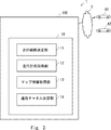
- FIG. It is a block diagram which shows the structure of the information processing apparatus which concerns on Embodiment 1.
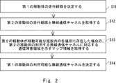
- FIG. It is a flowchart which shows the information processing method which concerns on Embodiment 1.
- FIG. It is a figure explaining the radio wave intensity map when the automatic guided vehicle which concerns on Embodiment 3 use the radio channel 1.
- FIG. It is a block diagram which shows the structure of the mobile body control system which concerns on Embodiment 3.
- FIG. 10 and FIG. 14 It is a figure explaining the symbol shown in the specific example of FIG. 10 and FIG. 14 which concerns on Embodiment 3.
- FIG. It is a figure explaining the example of the time-dependent change of the radio field intensity map of the radio communication channel 1 and 2 which concerns on Embodiment 3.
- FIG. It is a figure explaining the example of the time-dependent change of the radio field intensity map of the radio communication channel 1 and 2 which concerns on Embodiment 3.
- FIG. It is a figure explaining the example of the time-dependent change of the radio field intensity map of the radio communication channel 1 and 2 which concerns on Embodiment 3.
- FIG. It is a figure explaining the example of the time-dependent change of the radio field intensity map of the radio communication channel 1 and 2 which concerns on Embodiment 3.
- FIG. It is a figure explaining the example of the time-dependent change of the radio field intensity map of the radio communication channel 1 and 2 which concerns on Embodiment 3.
- FIG. It is a table which shows the running plan example of the automatic guided vehicle A1 and A2 which concerns on Embodiment 3. It is a table which shows the traveling plan example of the automatic guided vehicle A3 which concerns on Embodiment 3. It is a flowchart which shows the operation of the mobile body control system which concerns on Embodiment 4. It is a figure explaining another example of the time-dependent change of the radio field intensity map of the radio communication channel 1 and 2 which concerns on Embodiment 4.
- FIG. It is a figure explaining another example of the time-dependent change of the radio field intensity map of the radio communication channel 1 and 2 which concerns on Embodiment 4.
- FIG. It is a figure explaining another example of the time-dependent change of the radio field intensity map of the radio communication channel 1 and 2 which concerns on Embodiment 4.
- FIG. It is a table which shows the running plan example of the automatic guided vehicle A1 and A2 which concerns on Embodiment 4. It is a table which shows the traveling plan example of the automatic guided vehicle A3 which concerns on Embodiment 4. It is a block diagram which shows the hardware configuration example of an information processing apparatus 10.
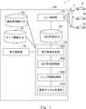
- FIG. 1 is a block diagram showing a configuration of an information processing apparatus according to the first embodiment.
- the information processing device 10 can be used to determine the travel path of the mobile body and the available wireless communication channels of the mobile body in the travel path.
- the information processing device 10 can be realized by a computer.
- the information processing device 10 includes a travel route determination unit 11, a travel plan acquisition unit 12, a map information acquisition unit 13, and a communication channel determination unit 14.
- the travel route determination unit 11 determines the travel route of the first moving body.
- Mobile objects include various objects such as vehicles, robots, and airplanes that can be remotely controlled and moved. A person may or may not be on the moving object.
- the travel route determination unit 11 may determine the travel start time and the travel end scheduled time for the first moving body. For example, when the travel route determination unit 11 receives a destination for the first mobile body, the travel route determination unit 11 can determine the current position of the first mobile body and the shortest route to the destination as the initial travel route.
- the travel plan acquisition unit 12 has a travel route for the second mobile body and a wireless communication channel used by the second mobile body at each location of the travel route based on the result determined by the travel route determination unit 11. And get.
- the second mobile body can be one or more mobile bodies.
- the travel route for the second mobile body and the wireless communication channel used at each location of the travel route are in the travel plan storage unit inside the information processing device or in an external device connected via a network. It is remembered in.
- the map information acquisition unit 13 provides map information indicating a communication failure area corresponding to the wireless communication channel used by the second mobile body when the second mobile body is present at each location in the movable facility. get.
- the communication failure area when used in the present specification, is referred to as an area in which communication is not possible because the radio field intensity is weaker than the threshold value.
- the layout of the facility can include multiple divided grids. The size of each grid can correspond to the size of the moving object. In the map information, a communication failure area or a communicable area is shown for each of the plurality of grids.
- the map information is stored in the map information storage unit inside the information processing device or in an external device connected via a network.
- the communication channel determination unit 14 determines a communication failure area corresponding to the wireless communication channel generated by the second mobile body in the traveling path of the first mobile body, and based on the communication failure area, the first mobile body. Determine the available wireless communication channels for.
- FIG. 2 is a flowchart showing an information processing method according to the first embodiment.
- the travel route determination unit 11 determines the travel route of the first moving body (step S11).
- the travel plan acquisition unit 12 has a travel route for the second mobile body and a wireless communication channel used by the second mobile body at each location of the travel route based on the result determined by the travel route determination unit 11. And are acquired (step S12).
- the map information acquisition unit 13 provides map information indicating a communication failure area corresponding to the wireless communication channel used by the second mobile body when the second mobile body is present at each location in the movable facility.
- Acquire step S13).
- the communication channel determination unit 14 determines a communication failure area corresponding to the wireless communication channel generated by the second mobile body in the traveling path of the first mobile body, and based on the communication failure area, the first mobile body.
- the available wireless communication channel of is determined (step S14).
- the target is in consideration of the traveling path and wireless communication channel of another mobile body (for example, a second mobile body, etc.), and the communication failure area that may be caused by the other mobile body. It is possible to determine the travel path and available wireless communication channel of the mobile body (for example, the first mobile body).
- FIG. 3 is a block diagram showing a configuration of the mobile control system 1 according to the second embodiment.
- the mobile body control system 1 includes a first mobile body A1 and a second mobile body A2 using a wireless communication channel, a control device 100 for controlling the first mobile body A1 (and the second mobile body A2), and a control device 100. including.
- the control device 100 includes the information processing device 10 according to the first embodiment. That is, the control device 100 has a travel route determination unit 11 that determines the travel route of the first mobile body A1, a travel route for the second mobile body A2 based on the determined result, and a travel route of the travel route.
- Wireless communication generated by the second mobile body A2 in the travel path of the first mobile body A1 and the map information acquisition unit 13 that acquires the map information indicating the communication failure area corresponding to the wireless communication channel used by the mobile body A2.
- a communication channel determination unit 14 for determining a communication failure area corresponding to a channel and determining an available wireless communication channel of the first mobile A1 based on the communication failure area is included.
- the target is in consideration of the traveling path and wireless communication channel of another mobile body (for example, a second mobile body, etc.), and the communication failure area that may be caused by the other mobile body. It is possible to determine the travel path and available wireless communication channel of the mobile body (for example, the first mobile body) and control the target mobile body according to the determined travel plan.
- the mobile body control system 1 remotely controls one or more mobile bodies (for example, an automatic guided vehicle) arranged in a facility such as a warehouse or a factory via a network.
- a plurality of access points are provided in the network, and wirelessly connect to a mobile body.
- the automatic guided vehicle (AGV) has a wireless interface corresponding to a plurality of wireless communication channels.
- the access point also supports a plurality of wireless communication channels. Examples of the channel include, but are not limited to, an 80 MHz channel and a 160 MHz channel in IEEE 802.11ac (Wi-Fi5).
- Wi-Fi5 IEEE 802.11ac
- various channels such as other IEEE 802.11 system, 4G, 5G (local 5G), LTE (Long Term Evolution), etc. may be used.
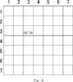
- FIG. 4 is a diagram illustrating an example of a grid map.
- the grid map is a map in which the layout of the facility is divided into a plurality of grids (7 ⁇ 7 grids in FIG. 4).
- FIG. 4 shows a square layout, showing that an automated guided vehicle (also called a transport robot) can move wirelessly across all grids of the layout.
- the transfer robot shown in FIG. 4 can move up, down, left, and right along the grid.
- the layout of the facility in the present disclosure is not limited to a square, and layouts having various shapes including a rectangle and a circle can be considered.
- FIG. 4 shows an all-uniform square grid, it may be a rectangular (non-square) grid or a grid of other suitable shapes.
- the grid map includes physical obstacles (for example, walls, installations, etc.) on which the automatic guided vehicle cannot travel and areas where the automatic guided vehicle cannot communicate (for example, weak radio wave areas where the radio field intensity is lower than the threshold value).
- One or more grids may be shown.
- the mobile control system 1 holds a grid map in a storage unit (also referred to as a map information database), and can manage the position of the AGV and the traveling route in grid units.
- the size of one grid may be set to the extent that one AGV can be accommodated, or it may be set to be smaller than the size of one AGV so that one AGV occupies a plurality of grids. ..
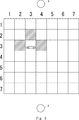
- FIG. 5 is a diagram illustrating a radio wave intensity map when the automatic guided vehicle according to the third embodiment uses the radio channel 1.
- the radio wave strength map shows a region where the radio wave strength is weaker than the threshold value and communication is not possible (hereinafter, also referred to as a communication failure region or a weak radio wave region) on the above-mentioned grid map.
- a communication failure region or a weak radio wave region As a method for predicting and measuring the radio field strength, a known method described in Japanese Patent Application Laid-Open No. 2012-137909 can be used.
- the communication failure area of the radio channel 1 caused by the automatic guided vehicle is detected in advance.
- the access point 9 located on one side of the facility (lower side in FIG. 5) is used.
- the grids before and after the automatic guided vehicle in the traveling direction and the grid on the right side that is, the grids (2,3), (4,3).
- the grids (2,3), (4,3). ) And (3, 2) are communication failure areas.
- the automatic guided vehicle moves to all the grids while using the radio channel 1, and prepares a radio field intensity map showing the communication failure area of the radio channel 1 caused by the automatic guided vehicle located on each grid.
- FIG. 6 is a diagram illustrating a radio field intensity map when the automatic guided vehicle according to the third embodiment uses the wireless channel 2.
- the access point 8 located on the other side of the facility (upper side in FIG. 6) is used.
- the grids before and after the automatic guided vehicle in the traveling direction and the grid on the left side that is, the grids (2,3), (4,3).
- ) And (3, 4) are communication failure areas of the radio channel 2.
- the automatic guided vehicle moves to all grids (except the grid with physical obstacles) while using the radio channel 2, and the communication failure of the radio channel 2 caused by the automatic guided vehicle located on each grid.
- the automatic guided vehicle of the same or similar type can be, for example, the same or similar shape, the same or similar structure, the same or similar model number, etc., thereby causing the same or similar communication failure area. be.
- the communication failure area that can be caused by each automatic guided vehicle may also be different. You may prepare. Further, in the above example, the radio field intensity map for two different radio channels is created, but even when there are three or more radio channels, the radio field strength map for each of the radio channels is created.
- the mobile body control system holds a radio wave intensity map in a storage unit (map information database), and can refer to the radio wave intensity map when determining the traveling route of the mobile body.
- the radio field intensity map may be measured and updated regularly. For example, all the automatic guided vehicles may be run in advance at the start of work and the radio field strength of each grid may be measured. Further, all the automatic guided vehicles may be run at a predetermined time (for example, 12 o'clock, etc.) and the radio field strength of each grid may be measured. All automatic guided vehicles may be run and the radio field strength of each grid may be measured at regular time intervals (every 6 hours, etc.).
- FIG. 7 is a block diagram showing a configuration example of a mobile body control system 1 that controls a mobile body.
- the mobile control system 1 is an information processing device (control device 100) realized by one or more computers, and a plurality of mobile bodies (A1 to A3 in FIG. 7) connected by the information processing device via a network 5. ) And, including.
- the moving body control system 1 includes an AGV control unit 101, a travel plan database 102, a map information database 103, a travel plan determination unit 105, and a travel instruction unit 104.
- the travel plan determination unit 105 may be realized by one information processing device, or the AGV control unit 101 may be realized by another information processing device.
- the AGV control unit 101 controls each automatic guided vehicle according to the travel plan stored in the travel plan database 102.
- the AGV control unit 101 wirelessly communicates with the automatic guided vehicle via an access point connected by a network, and controls the traveling thereof.
- the travel plan database 102 stores a travel route for each automatic guided vehicle and a wireless channel used when the automatic guided vehicle is located on each grid along the travel route as a travel plan.
- the automatic guided vehicle information database 106 can also store the characteristics (for example, moving speed) and size of each automatic guided vehicle.
- the travel plan database is also called a travel plan storage unit.
- the map information database 103 stores the above-mentioned grid map and radio field intensity map.
- the map information database is also called a map information storage unit.
- One of the features of the present disclosure is to determine an appropriate travel route and communication channel by referring to a radio field intensity map including a communication failure area for each radio communication channel caused by a mobile body.
- the travel plan database 102, the transport vehicle information database 106, and the map information database 103 may be provided inside the control device 100 or may be provided outside the control device 100 (for example, on the cloud side). Each function may be installed in one device or may be installed in separate devices.
- the device on the edge side can also determine the driving plan by referring to the database on the cloud side.
- the edge computer may aggregate the information of the automatic guided vehicles A1 and A2 and transmit the information processed by the edge computer to the cloud side.
- the travel plan determination unit 105 has a travel route determination unit 1051, a travel plan acquisition unit 1052, a map information acquisition unit 1053, and a communication channel determination unit 1054.
- the travel route determination unit 1051 receives the destination (and travel start time) of the target automatic guided vehicle from the travel instruction unit 104.
- the travel route determination unit 1051 determines a travel route (also referred to as an initial travel route) to the destination of the accepted automatic guided vehicle.
- the traveling route determination unit 1051 may determine the shortest route from the current position of the automatic guided vehicle to the destination as the traveling route.
- the travel route determination unit 1051 may determine the initial route so as to avoid the physical obstacles shown in the grid map.
- the initial travel route does not have to be a straight route, and may be a zigzag shortest route.
- the travel route determination unit 1053 can appropriately determine the travel route so as to have the minimum cost, the minimum power, the shortest distance, or the shortest time.
- the travel route determination unit 1051 can also determine the travel start time.
- the travel plan acquisition unit 1052 is used for the grid position (travel route) and each grid at each time (every unit time) of the other automatic guided vehicle between the travel start time and the travel end time of the target automatic guided vehicle.
- the wireless communication channel to be used is acquired from the travel plan database 102.
- the map information acquisition unit 1053 acquires map information indicating a communication failure area and a communicable area at each grid position of the other automatic guided vehicle in the traveling route of the other automatic guided vehicle.
- the map information acquisition unit 1052 also acquires map information for all available channels of the automatic guided vehicle.
- the map information acquisition unit 1053 performs a composite map (FIGS. 10 and 14) of each time for each automatic guided vehicle and other automatic guided vehicles for each radio channel (for example, radio channels 1 and 2 in this example). Can also be created.
- the communication channel determination unit 1054 determines the wireless communication channel used by the target automatic guided vehicle in each grid on the travel route (initial travel route) determined by the travel route determination unit 1051. Specifically, the communication channel determination unit 1054 refers to the travel route of another automatic guided vehicle stored in the travel route database 102 and the radio field intensity map showing the communication failure area stored in the map information database 103. Then, the wireless communication channel used by the target automatic guided vehicle is determined. If the communication channel determination unit 1054 cannot find a wireless communication channel capable of communicating with the target automatic guided vehicle on any of the grids, the communication channel determination unit 1051 again informs the travel route determination unit 1051 of the travel route (also referred to as a detour route). Can be instructed to decide.
- the travel route determination unit 1051 also referred to as a detour route
- the travel route determination unit 1053 avoids the communication failure area caused by the other automatic guided vehicle, and sets the travel route so that the communication failure area caused by the target automatic guided vehicle does not interfere with the communication of the other automatic guided vehicle. decide. In this case, the travel route determination unit 1053 can determine a detour route so as to find a wireless communication channel available on all grids by using A * (A-star) or the like and increasing the cost.
- the travel route determination unit 1051 considers the travel route of another automatic guided vehicle stored in the travel plan database 102 (that is, so as not to collide with another automatic guided vehicle), and the target automatic guided vehicle. It is also possible to determine the travel route of. Further, the traveling route determination unit 1053 can also determine the traveling route of the target automatic guided vehicle so as to avoid the physical obstacles shown in the grid map.
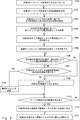
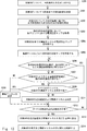
- FIG. 8 is a flowchart showing the operation of the mobile control system according to the third embodiment.
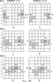
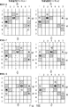
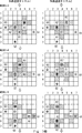
- FIG. 9 is a diagram illustrating symbols shown in specific examples of FIGS. 10 (10A to 10D) and 14 (14A to 14C).
- FIGS. 10 10A to 10D
- 14 14A to 14C
- three automatic guided vehicles A1, A2, and A3 are shown, respectively.
- the goals (destination) of the three automatic guided vehicles A1, A2, and A3 are indicated by G1, G2, and G3 (stars). Since the left figure and the right figure of FIG.
- FIGS. 9, 10 and 14 show maps at the same time, the positions of the three automatic guided vehicles A1, A2, and A3 in both figures are the same.
- the three automatic guided vehicles A1, A2 and A3 have the same type, the same shape and the same structure, and move at the same speed.
- automatic guided vehicles A1, A2, and A3 having different shapes, structures, and speeds may be used.
- the left figure of FIG. 9 is related to the wireless communication channel 1
- the right figure of FIG. 9 is related to the wireless communication channel 2.
- the left figure and the right figure of FIG. 9 are different communicable areas (blank grids) and different communication failure areas (hatched), respectively.
- the grid is shown.
- the automatic guided vehicles A1 and A2 are automatic guided vehicles whose goal (destination) is set to G3 when the traveling route and the wireless communication channel have already been determined.
- An example of determining a traveling route and a wireless communication channel of a vehicle A3 (also referred to as a target moving vehicle in the present specification) will be described.
- the travel plan determination unit 105 receives the destination of the automatic guided vehicle A3 from the travel instruction unit 104 (for example, via input by an operator or the like) (step S100).
- the travel plan determination unit 105 starts the process of determining the travel plan of the automatic guided vehicle A3 heading for the destination from the predetermined travel start time.
- the travel plan determination unit 105 may receive the destination and travel start time of the automatic guided vehicle A3 from the travel instruction unit 104 via input from an operator or the like.
- the traveling route determination unit 1051 determines the shortest route from the current position of the automatic guided vehicle A3 to the destination as the initial route (step S101).
- the automatic guided vehicle A3 starts traveling at time t, with the linear route from the grid (7, 4) to the grid (1, 4) as the initial route. ..
- the travel route determination unit 1051 can also determine the scheduled travel end time from the initial route and the speed of the automatic guided vehicle A3 (obtained from the database of the automatic guided vehicle).
- the travel plan acquisition unit 1052 acquires the travel plans of the other automatic guided vehicles A1 and A2 based on the determination result of the travel route determination unit 1053 for the automatic guided vehicle A3 (step S102). Specifically, the travel plan acquisition unit 1052 is a grid at each time (every unit time) of the other automatic guided vehicles A1 and A2 between the travel start time of the target automatic guided vehicle A3 and the scheduled travel end time. The location and the wireless communication channel to be used are read from the travel plan database 102. The scheduled travel end time may be set in consideration of the case where the automatic guided vehicle detours without passing through the initial route.
- the map information acquisition unit 1053 acquires a radio field intensity map in each grid of the other automated guided vehicle in the traveling route of the other automated guided vehicle (step S103). Specifically, the map information acquisition unit 1052 obtains a radio field intensity map of the automatic guided vehicle corresponding to each wireless communication channel located in each grid from the map information database 103 in the traveling route of the other automatic guided vehicles A1 and A2. get.
- the map information acquisition unit 1053 also acquires the radio field intensity map of all the radio channels (in this example, radio channels 1 and 2) of the target automatic guided vehicle A3 (step S104). These radio field intensity maps can be used in determining whether the communication failure area caused by the automatic guided vehicle A3 in question does not interfere with the communication of other automatic guided vehicles.
- the map information acquisition unit 1052 for all automatic guided vehicles that is, other automatic guided vehicles A1 and A2 and the target automatic guided vehicle A3) for each automatic channel (radio channels 1 and 2) at each time.
- Create a composite map (step S105).
- the created synthetic map is shown in FIGS. 10A to 10D.
- 10A to 10D show the positions of the automatic guided vehicles A1, A2, and A3 at times t to t + 10 and the communication failure area side by side for each of the two communication channels, the wireless communication channel 1 and the wireless communication channel 2. ..
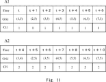
- FIGS. 10A to 10D the travel plans of the automatic guided vehicle A1 and the automatic guided vehicle A2 have already been determined and stored in the travel plan database 102. That is, the automatic guided vehicle A1 travels from the grid (1,5) to the grid (7,5) using the wireless communication channel 1 from t to t + 6, and the automatic guided vehicle A2 uses the wireless communication channel 2 from t + 4 to t + 10. It has already been decided to travel from the grid (1,3) to the grid (7,3), and it is stored in the travel plan database 102.
- FIG. 11 is a table showing an example of a traveling plan for the automatic guided vehicles A1 and A2. For each automatic guided vehicle, the table shows the position of the grid at each time and the radio channel (CH) used in each grid.
- CH radio channel
- the travel route and wireless communication channel of the automatic guided vehicle A3 from the grid (7, 4) to the grid (1, 4) are determined with time t as the travel start time.
- the linear route from the grid (7, 4) at the current position to the grid (1, 4) at the destination is determined as the initial route.
- the travel route determination unit 1051 may determine the initial route so as to avoid the physical obstacles shown in the grid map. That is, the initial path does not have to be a straight path, but may be a zigzag shortest path.
- the communication channel determination unit 1054 determines the wireless communication channel of the automatic guided vehicle A3 based on the map information indicating the communication failure area caused by the other automatic guided vehicle. Specifically, it is examined whether or not each grid along the initial route of the automatic guided vehicle A3 overlaps with the communication failure area of the radio field intensity map of the other automatic guided vehicle (step S106).
- the automatic guided vehicle A3 does not overlap with the communication failure area caused by the other automatic guided vehicle regardless of which of the wireless communication channels 1 and 2 is used. Further, the communication failure region caused by the automatic guided vehicle A3 does not interfere with the communication of the other automatic guided vehicles A1 and A2 in any of the wireless communication channels 1 and 2 (NO in step S107).
- the communication channel determination unit 1054 determines the wireless communication channel 1 to be used by the automatic guided vehicle A3 (step S108).
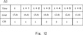
- the automatic guided vehicle A3 overlaps with the communication failure area of the wireless communication channel 1 generated by the automatic guided vehicle A1 on the grid (4, 4) (YES in step S106).
- the automatic guided vehicle A3 does not overlap with the communication failure area of the wireless communication channel 2. Therefore, the communication channel determination unit 1054 switches the automatic guided vehicle A3 to use the wireless communication channel 2. (Step S108). Further, the communication failure area of the wireless communication channel 2 caused by the automatic guided vehicle A3 overlaps with the position of the automatic guided vehicle A1, but since A1 communicates with the automatic guided vehicle A1, the communication interference by the automatic guided vehicle A3 is received. No.
- the automatic guided vehicle A3 determines to continue to use the wireless communication channel 2 when moving to the grid (3, 4) (step S108).
- the communication channel determination unit 1054 switches the automatic guided vehicle A3 to use the wireless communication channel 1. (Step S108). Further, the communication failure area of the communication channel 1 caused by the automatic guided vehicle A3 overlaps with the position of the automatic guided vehicle A2, but since A2 communicates on the wireless communication channel 2, it is not affected by the communication interference by the automatic guided vehicle A3. ..
- the automatic guided vehicle A3 determines to continue to use the wireless communication channel 1 when moving to the grid (1,4) (step S108). As described above, the travel plan of the automatic guided vehicle A3 at all times is determined (YES in step S112).
- the travel route and wireless communication channel of the automatic guided vehicle A3 are determined.
- the wireless communication channel of the automatic guided vehicle A3 can be determined on each grid (step S108) and the travel plan at all times has been determined (YES in step S112)
- the travel plan determination unit 105 determines the automatic guided vehicle A3.
- the determined travel route and the radio channel in each grid are registered in the travel plan database 102 (step S113).
- FIG. 12 is a table showing an example of a traveling plan for the automatic guided vehicle A3.
- the table shows the position of the grid at each time and the radio channel (CH) used in each grid.
- CH radio channel
- the AGV control unit 101 reads the travel plans of the automatic guided vehicles A1, A2, and A3 from the travel plan database 102, and controls the travel of each automatic guided vehicle and the switching of the radio channel according to the plan (step S114).
- the traveling route and the wireless communication channel of the target automatic guided vehicle can be appropriately determined. Further, the mobile body control system 1 can efficiently control the traveling of the automatic guided vehicle and the switching of the communication channel according to the determined traveling plan.
- the above example has described an example in which the automatic guided vehicle A3 can find a wireless channel that can be used on all grids in the initial route (shortest route) of the automatic guided vehicle A3.
- FIG. 13 is a flowchart showing the operation of the mobile control system according to the fourth embodiment.
- the travel plan determination unit 105 receives the destination of the automatic guided vehicle A3 from the travel instruction unit 104 via the input of the operator or the like (step S200).
- the travel plan determination unit 105 starts the process of determining the travel plan of the automatic guided vehicle A3 heading for the destination from the travel start time immediately after receiving the destination.
- the travel plan determination unit 105 may receive the destination and travel start time of the automatic guided vehicle A3 from the travel instruction unit 104 via input from an operator or the like.
- the traveling route determination unit 1051 determines the shortest route from the current position of the automatic guided vehicle A3 to the destination as the initial route (step S201).
- the automatic guided vehicle A3 travels at time t with the linear route of the automatic guided vehicle A3 from the grid (7,4) to the grid (1,4) as the initial route. It shall start in.
- the travel route determination unit 1051 can also determine the scheduled travel end time from the initial route and the speed of the automatic guided vehicle A3 (obtained from the database of the automatic guided vehicle).
- the travel plan acquisition unit 1052 acquires the travel plans of the other automatic guided vehicles A1 and A2 based on the determination result of the travel route determination unit 1051 for the automatic guided vehicle A3 (step S202). Specifically, the travel plan acquisition unit 1052 is a grid at each time (every unit time) of the other automatic guided vehicles A1 and A2 between the travel start time of the target automatic guided vehicle A3 and the scheduled travel end time. The location and the wireless communication channel to be used are read from the travel plan database 102. The scheduled travel end time may be set in consideration of the case where the target automatic guided vehicle detours without passing through the initial route.
- the map information acquisition unit 1053 acquires a radio field intensity map in each grid of the other automated guided vehicle in the traveling route of the other automated guided vehicle (step S203). Specifically, the map information acquisition unit 1053 obtains a radio field intensity map of the automatic guided vehicle corresponding to each wireless communication channel located in each grid from the map information database 103 in the traveling route of the other automatic guided vehicles A1 and A2. get.
- the map information acquisition unit 1053 also acquires the radio field intensity map of all the radio channels (in this example, radio channels 1 and 2) of the target automatic guided vehicle A3 (step S204).
- the map information acquisition unit 1052 is a composite map of each time for each automatic guided vehicle (that is, other automatic guided vehicles A1 and A2 and the target automatic guided vehicle A3) for each automatic guided vehicle (radio channels 1 and 2). Is created (step S205).
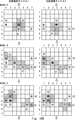
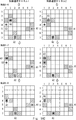
- the created synthetic map is shown in FIGS. 14A to 14C.
- 14A to 14C show the radio field intensity maps of the two communication channels, the wireless communication channel 1 and the wireless communication channel 2, side by side for the automatic guided vehicles A1, A2, and A3 at times t to t + 8.
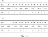
- FIGS. 14A to 14C the travel plans of the automatic guided vehicle A1 and the automatic guided vehicle A2 have already been determined and stored in the travel plan database 102. That is, the automatic guided vehicle A1 travels from the grid (1,5) to the grid (7,5) using the wireless communication channel 1 from t to t + 6, and the automatic guided vehicle A2 uses the wireless communication channel 2 from t to t + 6. It has already been decided to travel from the grid (3,1) to the grid (3,7), and it is stored in the travel plan database 102.
- FIG. 15 is a table showing an example of a traveling plan for the automatic guided vehicles A1 and A2. For each automatic guided vehicle, the table shows the position of the grid at each time and the radio channel (CH) used in each grid.
- CH radio channel
- the travel route and wireless communication channel of the automatic guided vehicle A3 from the grid (7, 4) to the grid (1, 4) are determined with time t as the travel start time.
- a linear route from the grid at the current position (7, 4) to the grid at the destination (1, 4) is set as the initial route.
- the travel plan determination unit 105 may determine the initial route so as not to collide with other automatic guided vehicles A1 and A2.
- the initial route may also be determined to avoid the physical obstacles shown in the grid map. That is, the initial path does not have to be a straight path, but may be a zigzag shortest path.
- the communication channel determination unit 1054 determines the wireless communication channel of the automatic guided vehicle A3 based on the map information indicating the communication failure area caused by the other automatic guided vehicle. Specifically, it is examined whether or not each grid along the initial route of the automatic guided vehicle A3 overlaps with the communication failure area of the radio field intensity map of the other automatic guided vehicle (step S206).
- the automatic guided vehicle A3 does not overlap with the communication failure area caused by the other automatic guided vehicle regardless of which of the wireless communication channels 1 and 2 is used. Further, the communication failure region caused by the automatic guided vehicle A3 does not interfere with the communication of the other automatic guided vehicles A1 and A2 in any of the wireless communication channels 1 and 2 (NO in step S207).
- the communication channel determination unit 1054 determines the wireless communication channel 1 to be used by the automatic guided vehicle A3 (step S209).
- the automatic guided vehicle A3 runs on the grid (4,4) at time t + 3, but the grid (4,4) at time t + 3 4) is a communication failure area of both the wireless communication channel 1 and the wireless communication channel 2 (YES in step S206). Further, when the automatic guided vehicle A3 moves to the grid (4, 4) at time t + 3, it also interferes with the communication channel 2 used by the automatic guided vehicle A2 (YES in step S207). That is, the communication channel determination unit 1054 cannot find an available radio channel on the grid (4, 4) in the initial route for the automatic guided vehicle A3 (NO in step S208).
- the traveling route determination unit 1051 avoids the communication failure area caused by the automatic guided vehicles A1 and 2, and further, the communication failure area caused by the automatic guided vehicle A3 does not interfere with the communication of the other automatic guided vehicles A1 and 2.
- the detour route and the radio channel are determined (step S211).
- the automatic guided vehicle A3 is determined to move to the grid (5, 3) at time t + 3.
- the travel route determination unit 1053 can determine a detour route so as to find a wireless communication channel available on all grids by using A * (A-star) or the like and increasing the cost.
- the automatic guided vehicle A3 sequentially moves to the left grid from time t + 4 to t + 7, and the automatic guided vehicle A3 reaches the destination grid (1, 4) at time t + 8. Determine the detour route to do so.
- the position of the automatic guided vehicle A3 does not overlap with the communication failure area of the wireless communication channels 1 and 2 caused by the automatic guided vehicles A1 and 2.
- the communication failure area of the wireless communication channels 1 and 2 generated by the automatic guided vehicle A3 does not interfere with the communication of the other automatic guided vehicles A1 and 2. Therefore, here, the communication channel determination unit 1054 determines that the automatic guided vehicle A3 uses the radio channel 1.
- the communication channel determination unit 1054 when the communication channel determination unit 1054 cannot find a communicable wireless communication channel in any grid on the shortest path (NO in step S208), the communication channel determination unit 1053 again determines the travel route. It is possible to instruct the traveling route to be determined again (step S211).
- the travel route and wireless communication channel of the automatic guided vehicle A3 are determined.
- the wireless communication channel of the automatic guided vehicle A3 is determined on all grids in the detour route to the destination (step S211) and the travel plan at all times has been determined (YES in step S212)
- the travel plan determination unit 105 Registers the determined travel route and the radio channel in each grid in the travel plan database 102 for the automatic guided vehicle A3 (step S213).
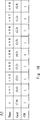
- FIG. 16 is a table showing an example of a traveling plan of the automatic guided vehicle A3 according to the third embodiment.
- the table shows the position of the grid at each time and the radio channel (CH) used in each grid for each automatic guided vehicle A3.
- CH radio channel
- the AGV control unit 101 reads the travel plans of the automatic guided vehicles A1, A2, and A3 from the travel plan database 102, and controls the travel of each automatic guided vehicle and the switching of the radio channel according to the plan (step S214).
- the route can be calculated by using an algorithm such as A * and increasing the cost of the grid in the communication failure area at each time to calculate the route to avoid the grid in the communication failure area.
- the traveling route and the wireless communication channel of the target automatic guided vehicle can be appropriately determined. Further, the mobile body control system 1 can efficiently control the traveling of the automatic guided vehicle and the switching of the communication channel according to the determined traveling plan.
- a plurality of wireless communication channels are prepared, and the radio wave strength of each communication channel when the AGV travels in each place in the facility is measured and referred to at the time of route calculation. It is possible to calculate a route that predicts the influence of the AGV on the radio communication and the influence of other AGVs on the radio communication. By calculating the route to avoid the communication failure area in advance while switching the wireless communication channel, stable and efficient traveling of a plurality of AGVs becomes possible. In the above-mentioned mobile control system, the amount of calculation processing can be suppressed by managing the traveling route and the radio wave intensity on the grid.
- FIGS. 8 and 13 show the specific order of execution, but the order of execution may be different from the drawn form. For example, the order of execution of two or more steps may be swapped with respect to the indicated order. Also, the two or more steps shown in succession in FIGS. 8 and 13 may be performed simultaneously or partially simultaneously. Further, in some embodiments, one or more steps shown in FIGS. 8 and 13 may be skipped or omitted.
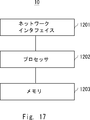
- FIG. 17 is a block diagram showing a hardware configuration example of the information processing device 10 and the control device 100 (hereinafter referred to as the information processing device 10 and the like).
- the information processing apparatus 10 and the like include a network interface 1201, a processor 1202, and a memory 1203.
- the network interface 1201 is used to communicate with other network node devices constituting the communication system.
- Network interface 1201 may be used to perform wireless communication.
- the network interface 1201 may be used to perform wireless LAN communication specified in the IEEE 802.11 series or mobile communication specified in 3GPP (3rd Generation Partnership Project).
- the network interface 1201 may include, for example, a network interface card (NIC) compliant with the IEEE802.3 series.
- NIC network interface card
- the processor 1202 reads software (computer program) from the memory 1203 and executes it to perform processing of the information processing apparatus 10 or the like described by using the flowchart or the sequence in the above-described embodiment.
- the processor 1202 may be, for example, a microprocessor, an MPU (MicroProcessingUnit), or a CPU (CentralProcessingUnit).
- Processor 1202 may include a plurality of processors.
- Memory 1203 is composed of a combination of volatile memory and non-volatile memory. Memory 1203 may include storage located away from processor 1202. In this case, processor 1202 may access memory 1203 via an I / O interface (not shown).
- the memory 1203 is used to store the software module group.
- the processor 1202 can perform the processing of the information processing apparatus 10 and the like described in the above-described embodiment.
- Each of the processors included in the information processing apparatus 10 and the like executes one or a plurality of programs including a group of instructions for causing a computer to perform an algorithm described using drawings.
- Non-temporary computer-readable media include various types of tangible storage media.
- Examples of non-temporary computer-readable media include magnetic recording media, magneto-optical recording media (eg, magneto-optical disks), CD-ROMs (Read OnlyMemory), CD-Rs, CD-R / Ws, and semiconductor memories.
- the magnetic recording medium may be, for example, a flexible disk, a magnetic tape, or a hard disk drive.
- the semiconductor memory may be, for example, a mask ROM, a PROM (Programmable ROM), an EPROM (Erasable PROM), a flash ROM, or a RAM (Random Access Memory).
- the program may also be supplied to the computer by various types of temporary computer readable medium.
- temporary computer-readable media include electrical, optical, and electromagnetic waves.
- the temporary computer-readable medium can supply the program to the computer via a wired communication path such as an electric wire and an optical fiber, or a wireless communication path.
- a travel route determination unit that determines the travel route of the first moving body, Based on the determined result, a travel plan acquisition unit that acquires a travel route for the second mobile body and a wireless communication channel used by the second mobile unit at each location of the travel route.
- a map information acquisition unit that acquires map information indicating a communication failure area corresponding to a wireless communication channel used by the second mobile body when the second mobile body is present at each location in a movable facility.
- Communication channel determination unit that determines the wireless communication channel, An information processing device.
- Appendix 2 The information processing device according to Appendix 1, wherein the travel route determination unit determines a travel start time and a travel end scheduled time.
- Appendix 3 The information processing device according to Appendix 1, wherein the traveling route determining unit determines the shortest route to the current position and the destination of the first moving body as a traveling route.
- Appendix 4 The map information acquisition unit indicates a communication failure area of one or more radio channels in which the first mobile body can be used when the first mobile body is present at each location in a movable facility.
- the information processing apparatus according to Appendix 1, which acquires map information.
- a first mobile and a second mobile using a wireless communication channel Including a control device for controlling the first moving body
- the control device is A traveling route determining unit that determines a traveling route of the first moving body, and a traveling route determining unit. Based on the determined result, a travel plan acquisition unit that acquires a travel route for the second mobile body and a wireless communication channel used by the second mobile unit at each location of the travel route.
- a map information acquisition unit that acquires map information indicating a communication failure area corresponding to a wireless communication channel used by the second mobile body when the second mobile body is present at each location in a movable facility.
- a communication failure area corresponding to the wireless communication channel generated by the second mobile body is determined, and the first mobile body can be used based on the communication failure area.
- Communication channel determination unit that determines the wireless communication channel, Mobile control system, including.
- Appendix 8 The moving body control system according to Appendix 7, wherein the traveling route determining unit determines a traveling start time and a traveling end scheduled time.
- Appendix 9 The moving body control system according to Appendix 7, wherein the traveling route determining unit determines the shortest route to the current position and the destination of the first moving body as a traveling route.
- the map information acquisition unit indicates a communication failure area of one or more radio channels in which the first mobile body can be used when the first mobile body is present at each location in a movable facility.
- the mobile control system according to Appendix 7, which acquires map information.
- the travel route determination unit may determine the second travel path. 9. A description of Appendix 9, wherein the traveling route is determined so as to avoid the communication failure area caused by the moving body of the above and to prevent the communication failure area caused by the first moving body from interfering with the communication of the second moving body.
- An information processing method that determines the wireless communication channel (Appendix 14) The information processing method according to Appendix 13, which determines the travel route, travel start time, and travel end scheduled time. (Appendix 15) The information processing method according to Appendix 13, wherein the shortest route to the current position and the destination of the first moving body is determined as a traveling route. (Appendix 16) Addendum, which acquires map information indicating a communication failure area of one or more radio channels available to the first mobile when the first mobile is present at each location in a mobile facility. The information processing method according to 13. (Appendix 17) If the available wireless communication channel of the first mobile cannot be determined at any location on the travel path of the first mobile.
- Appendix 16 The travel route is determined so as to avoid the communication failure area caused by the second mobile body and to prevent the communication failure area caused by the first mobile body from interfering with the communication of the second mobile body.
- Information processing method described in. (Appendix 18) The information processing method according to Appendix 13, wherein the area in the facility is divided by a grid indicating a size in which one moving body can be accommodated.
- Appendix 19 The process of determining the travel route of the first moving body and Based on the determined result, a process of acquiring a travel path for the second mobile body and a wireless communication channel used by the second mobile body at each location of the travel path.
- a communication failure area corresponding to the wireless communication channel generated by the second mobile body is determined, and the first mobile body can be used based on the communication failure area.
- a program that causes a computer to execute the process of determining a wireless communication channel. (Appendix 20) The program according to Appendix 19, which determines the travel route, travel start time, and travel end scheduled time. (Appendix 21) The program according to Appendix 19, wherein the shortest route to the current position and the destination of the first moving body is determined as a traveling route.
- (Appendix 22) Addendum to acquire map information indicating a communication failure area of one or more radio channels available to the first mobile when the first mobile is present at each location in a mobile facility.
- the program described in 19. (Appendix 23) If the available wireless communication channel of the first mobile cannot be determined at any location on the travel path of the first mobile. Appendix 22 that avoids the communication failure area caused by the second mobile body and determines the traveling route so that the communication failure area caused by the first mobile body does not interfere with the communication of the second mobile body.
- the program described in. (Appendix 24) The program according to Appendix 19, wherein the area in the facility is divided by a grid indicating a size in which one moving body can be accommodated.
Landscapes
- Engineering & Computer Science (AREA)
- Radar, Positioning & Navigation (AREA)
- Remote Sensing (AREA)
- Physics & Mathematics (AREA)
- General Physics & Mathematics (AREA)
- Automation & Control Theory (AREA)
- Computer Security & Cryptography (AREA)
- Computer Networks & Wireless Communication (AREA)
- Signal Processing (AREA)
- Navigation (AREA)
- Traffic Control Systems (AREA)
- Mobile Radio Communication Systems (AREA)
- Control Of Position, Course, Altitude, Or Attitude Of Moving Bodies (AREA)
Priority Applications (2)
| Application Number | Priority Date | Filing Date | Title |
|---|---|---|---|
| US18/011,703 US20230251098A1 (en) | 2020-06-30 | 2021-05-17 | Information processing apparatus, mobile-body control system, and information processing method |
| JP2022533721A JP7416250B2 (ja) | 2020-06-30 | 2021-05-17 | 情報処理装置、移動体制御システム、情報処理方法及びプログラム |
Applications Claiming Priority (2)
| Application Number | Priority Date | Filing Date | Title |
|---|---|---|---|
| JP2020-112327 | 2020-06-30 | ||
| JP2020112327 | 2020-06-30 |
Publications (1)
| Publication Number | Publication Date |
|---|---|
| WO2022004163A1 true WO2022004163A1 (ja) | 2022-01-06 |
Family
ID=79315939
Family Applications (1)
| Application Number | Title | Priority Date | Filing Date |
|---|---|---|---|
| PCT/JP2021/018665 Ceased WO2022004163A1 (ja) | 2020-06-30 | 2021-05-17 | 情報処理装置、移動体制御システム、及び情報処理方法 |
Country Status (3)
| Country | Link |
|---|---|
| US (1) | US20230251098A1 (cg-RX-API-DMAC7.html) |
| JP (1) | JP7416250B2 (cg-RX-API-DMAC7.html) |
| WO (1) | WO2022004163A1 (cg-RX-API-DMAC7.html) |
Cited By (2)
| Publication number | Priority date | Publication date | Assignee | Title |
|---|---|---|---|---|
| WO2024202949A1 (ja) * | 2023-03-29 | 2024-10-03 | 国立研究開発法人情報通信研究機構 | 通信システム |
| WO2025109963A1 (ja) * | 2023-11-20 | 2025-05-30 | 株式会社日立製作所 | 移動体管制装置、車両管制方法、及び車両 |
Families Citing this family (2)
| Publication number | Priority date | Publication date | Assignee | Title |
|---|---|---|---|---|
| CN113960996B (zh) * | 2020-07-20 | 2025-05-23 | 华为技术有限公司 | 行驶装置的避障路径的规划方法和装置 |
| JP2023118510A (ja) * | 2022-02-15 | 2023-08-25 | オムロン株式会社 | 走行装置 |
Citations (5)
| Publication number | Priority date | Publication date | Assignee | Title |
|---|---|---|---|---|
| JP2004280213A (ja) * | 2003-03-13 | 2004-10-07 | Japan Science & Technology Agency | 分散型経路計画装置及び方法、分散型経路計画プログラム |
| JP2005044099A (ja) * | 2003-07-28 | 2005-02-17 | Mazda Motor Corp | 部品供給システム、制御装置及び制御方法 |
| WO2018066069A1 (ja) * | 2016-10-04 | 2018-04-12 | 日産自動車株式会社 | 駐車制御方法及び駐車制御装置 |
| JP2019148870A (ja) * | 2018-02-26 | 2019-09-05 | 日本電産シンポ株式会社 | 移動体管理システム |
| EP3570133A1 (en) * | 2018-05-16 | 2019-11-20 | Siemens Aktiengesellschaft | Method and system for controlling a vehicle moving within an environment |
Family Cites Families (8)
| Publication number | Priority date | Publication date | Assignee | Title |
|---|---|---|---|---|
| JP4957799B2 (ja) | 2007-06-15 | 2012-06-20 | 富士通株式会社 | ロボットおよび案内方法 |
| JP2014057161A (ja) * | 2012-09-11 | 2014-03-27 | Pioneer Electronic Corp | 無線通信装置及び通信制御方法 |
| EP2965583B1 (en) * | 2013-03-04 | 2018-08-01 | Telefonaktiebolaget LM Ericsson (publ) | Control channel quality based scheduling of radio transmissions |
| JP7108499B2 (ja) | 2018-08-28 | 2022-07-28 | ヤンマーパワーテクノロジー株式会社 | 自動走行システム |
| JP6997059B2 (ja) | 2018-09-28 | 2022-01-17 | Kddi株式会社 | 干渉調整装置、干渉調整方法及びプログラム |
| US11283529B2 (en) * | 2019-02-19 | 2022-03-22 | At&T Intellectual Property I, L.P. | Network management of aerial devices |
| NZ781258A (en) * | 2019-04-08 | 2022-07-01 | Lineage Logistics Llc | Automatic transportation of pallets of goods |
| JP7041111B2 (ja) * | 2019-10-15 | 2022-03-23 | 本田技研工業株式会社 | 管理装置 |
-
2021
- 2021-05-17 WO PCT/JP2021/018665 patent/WO2022004163A1/ja not_active Ceased
- 2021-05-17 US US18/011,703 patent/US20230251098A1/en not_active Abandoned
- 2021-05-17 JP JP2022533721A patent/JP7416250B2/ja active Active
Patent Citations (5)
| Publication number | Priority date | Publication date | Assignee | Title |
|---|---|---|---|---|
| JP2004280213A (ja) * | 2003-03-13 | 2004-10-07 | Japan Science & Technology Agency | 分散型経路計画装置及び方法、分散型経路計画プログラム |
| JP2005044099A (ja) * | 2003-07-28 | 2005-02-17 | Mazda Motor Corp | 部品供給システム、制御装置及び制御方法 |
| WO2018066069A1 (ja) * | 2016-10-04 | 2018-04-12 | 日産自動車株式会社 | 駐車制御方法及び駐車制御装置 |
| JP2019148870A (ja) * | 2018-02-26 | 2019-09-05 | 日本電産シンポ株式会社 | 移動体管理システム |
| EP3570133A1 (en) * | 2018-05-16 | 2019-11-20 | Siemens Aktiengesellschaft | Method and system for controlling a vehicle moving within an environment |
Cited By (2)
| Publication number | Priority date | Publication date | Assignee | Title |
|---|---|---|---|---|
| WO2024202949A1 (ja) * | 2023-03-29 | 2024-10-03 | 国立研究開発法人情報通信研究機構 | 通信システム |
| WO2025109963A1 (ja) * | 2023-11-20 | 2025-05-30 | 株式会社日立製作所 | 移動体管制装置、車両管制方法、及び車両 |
Also Published As
| Publication number | Publication date |
|---|---|
| JPWO2022004163A1 (cg-RX-API-DMAC7.html) | 2022-01-06 |
| JP7416250B2 (ja) | 2024-01-17 |
| US20230251098A1 (en) | 2023-08-10 |
Similar Documents
| Publication | Publication Date | Title |
|---|---|---|
| JP7416250B2 (ja) | 情報処理装置、移動体制御システム、情報処理方法及びプログラム | |
| EP4141599B1 (en) | Multi-robot route planning | |
| US20240419170A1 (en) | Robot-Assisted Processing of a Surface Using a Robot | |
| Bhargava et al. | A review of recent advances, techniques, and control algorithms for automated guided vehicle systems | |
| CN111426326A (zh) | 一种导航方法、装置、设备、系统及存储介质 | |
| US20230273621A1 (en) | Information processing apparatus, information processing method, and program | |
| KR20190008709A (ko) | 자율주행 로봇 장치 및 자율 주행 방법 | |
| JP2010191502A (ja) | 移動ロボット制御システム、経路探索方法、経路探索プログラム | |
| EP4155860B1 (en) | System and safety guide robot for accessing automated environments | |
| CN115968457B (zh) | 信息处理装置、信息处理方法和程序 | |
| US12541205B2 (en) | Movement control support device and method | |
| Wang et al. | Wide range global path planning for a large number of networked mobile robots based on generalized Voronoi diagrams | |
| CN115480567B (zh) | 路径规划方法及装置、机器人及计算机可读存储介质 | |
| JP2019148870A (ja) | 移動体管理システム | |
| CN115328156A (zh) | 路径规划方法及装置、机器人及计算机可读存储介质 | |
| US20210365043A1 (en) | System and method for guiding vehicles and computer program product | |
| Wei et al. | Altruistic coordination for multi-robot cooperative pathfinding | |
| CN110673594A (zh) | 一种用于amr集群的调度和寻路方法及系统 | |
| US20250244776A1 (en) | Control method, control device, and non-transitory computer readable storage medium | |
| Žužek et al. | Simulation-based approach for automatic roadmap design in multi-agv systems | |
| JP5732921B2 (ja) | 移動体マップ装置、その処理方法及びプログラム | |
| KR101401311B1 (ko) | 복수의 이동체의 경로를 계획하는 장치 및 방법 | |
| CN119803505A (zh) | 路径规划方法及相关设备 | |
| US20240294087A1 (en) | Systems and methods for controlling vehicle movement in a parking lot | |
| KR101079192B1 (ko) | 경로추적을 이용한 자율 주행 장치의 트래픽 제어 방법 |
Legal Events
| Date | Code | Title | Description |
|---|---|---|---|
| 121 | Ep: the epo has been informed by wipo that ep was designated in this application |
Ref document number: 21832770 Country of ref document: EP Kind code of ref document: A1 |
|
| ENP | Entry into the national phase |
Ref document number: 2022533721 Country of ref document: JP Kind code of ref document: A |
|
| NENP | Non-entry into the national phase |
Ref country code: DE |
|
| 122 | Ep: pct application non-entry in european phase |
Ref document number: 21832770 Country of ref document: EP Kind code of ref document: A1 |