WO2020079907A1 - Dispositif de détermination d'enregistrement d'arrivée - Google Patents
Dispositif de détermination d'enregistrement d'arrivée Download PDFInfo
- Publication number
- WO2020079907A1 WO2020079907A1 PCT/JP2019/028707 JP2019028707W WO2020079907A1 WO 2020079907 A1 WO2020079907 A1 WO 2020079907A1 JP 2019028707 W JP2019028707 W JP 2019028707W WO 2020079907 A1 WO2020079907 A1 WO 2020079907A1
- Authority
- WO
- WIPO (PCT)
- Prior art keywords
- geofence
- check
- information
- terminal
- determination
- Prior art date
Links
- 230000001174 ascending effect Effects 0.000 claims description 10
- 238000000034 method Methods 0.000 description 22
- 238000004364 calculation method Methods 0.000 description 15
- 230000008569 process Effects 0.000 description 15
- 238000004891 communication Methods 0.000 description 12
- 238000012545 processing Methods 0.000 description 11
- 238000010586 diagram Methods 0.000 description 10
- 230000006870 function Effects 0.000 description 8
- 230000005540 biological transmission Effects 0.000 description 6
- 238000005516 engineering process Methods 0.000 description 5
- 238000010295 mobile communication Methods 0.000 description 3
- 230000009471 action Effects 0.000 description 2
- 230000000694 effects Effects 0.000 description 2
- 230000003287 optical effect Effects 0.000 description 2
- 238000012790 confirmation Methods 0.000 description 1
- 230000008878 coupling Effects 0.000 description 1
- 238000010168 coupling process Methods 0.000 description 1
- 238000005859 coupling reaction Methods 0.000 description 1
- 238000009795 derivation Methods 0.000 description 1
- 230000001939 inductive effect Effects 0.000 description 1
- 238000011835 investigation Methods 0.000 description 1
- 230000007774 longterm Effects 0.000 description 1
- 239000006249 magnetic particle Substances 0.000 description 1
- 238000013507 mapping Methods 0.000 description 1
- 238000005259 measurement Methods 0.000 description 1
- 230000007246 mechanism Effects 0.000 description 1
- 239000013307 optical fiber Substances 0.000 description 1
- 230000002093 peripheral effect Effects 0.000 description 1
- 239000007787 solid Substances 0.000 description 1
- 238000013519 translation Methods 0.000 description 1
- 230000014616 translation Effects 0.000 description 1
Images


Classifications
-
- H—ELECTRICITY
- H04—ELECTRIC COMMUNICATION TECHNIQUE
- H04W—WIRELESS COMMUNICATION NETWORKS
- H04W4/00—Services specially adapted for wireless communication networks; Facilities therefor
- H04W4/02—Services making use of location information
- H04W4/021—Services related to particular areas, e.g. point of interest [POI] services, venue services or geofences
-
- G—PHYSICS
- G06—COMPUTING; CALCULATING OR COUNTING
- G06F—ELECTRIC DIGITAL DATA PROCESSING
- G06F13/00—Interconnection of, or transfer of information or other signals between, memories, input/output devices or central processing units
-
- G—PHYSICS
- G06—COMPUTING; CALCULATING OR COUNTING
- G06Q—INFORMATION AND COMMUNICATION TECHNOLOGY [ICT] SPECIALLY ADAPTED FOR ADMINISTRATIVE, COMMERCIAL, FINANCIAL, MANAGERIAL OR SUPERVISORY PURPOSES; SYSTEMS OR METHODS SPECIALLY ADAPTED FOR ADMINISTRATIVE, COMMERCIAL, FINANCIAL, MANAGERIAL OR SUPERVISORY PURPOSES, NOT OTHERWISE PROVIDED FOR
- G06Q50/00—Information and communication technology [ICT] specially adapted for implementation of business processes of specific business sectors, e.g. utilities or tourism
- G06Q50/10—Services
-
- Y—GENERAL TAGGING OF NEW TECHNOLOGICAL DEVELOPMENTS; GENERAL TAGGING OF CROSS-SECTIONAL TECHNOLOGIES SPANNING OVER SEVERAL SECTIONS OF THE IPC; TECHNICAL SUBJECTS COVERED BY FORMER USPC CROSS-REFERENCE ART COLLECTIONS [XRACs] AND DIGESTS
- Y02—TECHNOLOGIES OR APPLICATIONS FOR MITIGATION OR ADAPTATION AGAINST CLIMATE CHANGE
- Y02D—CLIMATE CHANGE MITIGATION TECHNOLOGIES IN INFORMATION AND COMMUNICATION TECHNOLOGIES [ICT], I.E. INFORMATION AND COMMUNICATION TECHNOLOGIES AIMING AT THE REDUCTION OF THEIR OWN ENERGY USE
- Y02D30/00—Reducing energy consumption in communication networks
- Y02D30/70—Reducing energy consumption in communication networks in wireless communication networks
Definitions
- One aspect of the present disclosure relates to a check-in determination device that determines a check-in indicating that a terminal has entered a geofence that is a predetermined geographical range.
- Patent Document 1 discloses a geofence management system that determines that a user device has entered a geofence boundary that includes an associated point of interest.
- the device that determines the check-in of the terminal to the geofence determines the check-in of the terminal to each of all the geofences registered in advance. Therefore, if the number of geofences registered in advance is large, there is a problem that it takes time to determine the check-in of the terminal.
- one aspect of the present disclosure has been made in view of such problems, and an object thereof is to provide a check-in determination device that can determine check-in at a higher speed.
- a check-in determination device is a check-in determination device that determines a check-in indicating that a terminal has entered a geofence that is a predetermined geographical range. Then, for each geofence, a storage unit that stores related geofence information that associates related geofences that are other geofences based on the distance from the geofence and a check-in of the terminal for each geofence in order. And a determination unit that determines that the terminal has checked in with respect to one geofence, the determination unit is associated with the one geofence in the related geofence information stored by the storage unit. Related Geofences are excluded from judgment in the subsequent judgments.
- a check-in determination device in the determination of the check-in of the terminal, when it is determined that the check-in is made to one geofence, the relation associated with the one geofence based on the distance. Geofence is excluded from judgment. This is because, for example, when a terminal checks in to one geofence, the terminal is likely to check in to a related geofence associated with the one geofence based on distance. Therefore, the determination of the relevant geofence can be omitted. As described above, since it is possible to reduce the number of geofences that are the targets of check-in determination, check-in can be determined at a higher speed.
- check-in can be determined faster.
- the check-in determination system 3 includes a check-in determination device 1 and one or more terminals 2.
- the check-in determination device 1 and each terminal 2 are connected to each other via a mobile communication network or a network such as a wireless LAN (Local Area Network) so that they can access each other.
- a mobile communication network or a network such as a wireless LAN (Local Area Network) so that they can access each other.
- a wireless LAN Local Area Network
- the check-in determination device 1 is a computer device such as a server.
- the check-in determination device 1 determines the check-in indicating that the terminal 2 has entered the geofence, which is a predetermined geographical range. Details of the function of the check-in determination device 1 will be described later.
- Geo-fence is a virtual geographical boundary line or area that is set at any point in the real world.
- the geofence is represented by a circle defined by a center indicated by latitude and longitude and a radius indicated by a distance, but the present invention is not limited to this.
- a geofence may be a geographic area bounded by any curve and / or line.
- the geofence is not limited to the two-dimensional space, but may be a range that spreads in a three-dimensional space such as a sphere or a solid.
- Check-in specifically indicates that the terminal 2 has crossed the geofence geographical boundary or that the terminal 2 has entered the geofence area. Checking in indicates that the terminal 2 crosses the geofence geographical boundary line, or that the terminal 2 enters the area of the geofence. Determining check-in means determining whether the terminal 2 has checked in (entered) the geofence, or determining that the terminal 2 has checked in (entered) the geofence. Indicates that As an example of using the check-in determination, a geofence centering on a certain store is set in advance, and it is determined that the terminal 2 carried by the user has checked in to the geofence (that is, approaching the store). At this time, there is a mechanism for inducing purchase, in which the coupon of the store is distributed to the terminal 2, the user sees the distributed coupon and the purchase desire is increased, and the user stops at the store.
- FIG. 2 is a diagram for explaining check-in. As shown in FIG. 2, three geofences, that is, a geofence Ga, a geofence Gb, and a geofence Gc are formed in advance. FIG. 2 shows a scene in which the terminal 2 moves into the geofence Ga and the terminal 2 checks in to the geofence Ga. Note that the terminal 2 may check-in to multiple geofences at once. For example, in FIG. 2, when the terminal 2 moves to a range where the geofence Ga and the geofence Gc overlap, the terminal 2 checks in to each of the geofence Ga and the geofence Gc.
- the terminal 2 is a computer device such as a smartphone.
- the terminal 2 may be carried by the user, or may be installed in a machine or device such as an automobile.
- the terminal 2 is assumed to move geographically, but is not limited thereto.
- the terminal 2 transmits position specifying information capable of specifying the position of the terminal 2 to the check-in determination device 1 (the position specifying information acquisition unit 13 described later).
- the transmission timing may be regular (for example, once a minute) or may be any timing based on an instruction from the user or the check-in determination device 1.
- the position specifying information is Lat (Latitude) which is the latitude and Lon (longitude) which is the longitude (and may include error information) acquired by the GPS (Global Positioning System) of the terminal 2, or , SSID (Service Set IDentifier) or BSSID (Basic Service Set IDentifier) related to the network that the terminal 2 is accessing, but not limited to these, and any information that can identify the position of the terminal 2 Good.
- the position of the terminal 2 based on the SSID or BSSID can be specified based on pre-registered position information (latitude, longitude, etc.) of a network relay device such as an access point indicated by the SSID or BSSID, but is not limited to this. Not a thing.
- the position specifying information will be described below as latitude and longitude, but may be appropriately replaced with SSID or BSSID or other position specifying information.
- the position specifying information may further include a UUID (Universally Unique Identifier) that is the identification information of the terminal 2 and a datetime (date and time) indicating the timing at which the position specifying information is acquired.
- UUID Universalally Unique Identifier
- the terminal 2 may receive the determination result by the check-in determination device 1 or information based on the determination result from the check-in determination device 1 or another device connected via the network, and display the information to the user. For example, the terminal 2 displays information indicating that a terminal has checked in to a geofence, or coupon information related to a coupon of the shop associated with the fact that the terminal 2 is determined to check in to a geofence formed by a shop. It may be received and displayed.
- FIG. 3 is a functional block diagram of the check-in determination device 1.
- the check-in determination device 1 includes a geofence information storage unit 10, a related geofence information creation unit 11 (a creation unit), a related geofence information storage unit 12 (a storage unit), and a position identification information acquisition unit 13. And a check-in determination unit 14 (determination unit).
- a geofence information storage unit 10 a geofence information storage unit 10
- a related geofence information creation unit 11 a creation unit
- a related geofence information storage unit 12 a storage unit
- a position identification information acquisition unit 13 a position identification information acquisition unit
- a check-in determination unit 14 determination unit
- the geofence information storage unit 10 stores geofence information that is information about the geofence.
- Geofence information is information that specifically defines a geofence.
- FIG. 4 is a diagram showing an example of a table of geofence information. As shown in FIG. 4, the geofence information includes a point name that is a name for identifying the geofence, Lat that is the latitude of the center of the geofence, Lon that is the longitude of the center of the geofence, and the radius of the geofence. Are associated with. For example, in the first record of the example of the geofence information table shown in FIG.
- the geofence information may include some of the point name, Lat, Lon, and radius, or may include other information in association with each other.
- the geofence information may be created in advance by the administrator of the check-in determination device 1 or the like, or may be created mechanically by a computer device based on the existing information about the geofence.
- the geofence information stored by the geofence information storage unit 10 is information about all the geofences set / registered in advance for a specific area or area, but the geofence information is not limited to this. . Further, the geofence information stored by the geofence information storage unit 10 may be sorted (sorted) in ascending order of geographic range with respect to each geofence.
- the related geofence information creating unit 11 Based on the geofence information stored by the geofence information storage unit 10, the related geofence information creating unit 11 associates, with respect to each geofence, a related geofence that is another geofence, based on the distance from the geofence. Create relevant geofence information. For example, the related geofence information creating unit 11 determines, for each geofence indicated by the geofence information stored by the geofence information storage unit 10, a predetermined distance from the center of the geofence or an arbitrary point within the geofence ( Related geofence information may be created by associating other geofences indicated by the relevant geofence information with a part of the geographical range within 100 meters as a related geofence.
- the related geofence information creating unit 11 creates related geofence information that associates related geofences in which at least a part of the geofences of each geofence overlaps (with some overlap). Good. For example, in FIG. 5, since at least part of the geofence G1 overlaps the geofence G2, the related geofence information creating unit 11 associates the geofence G2 with the geofence G2 as a related geofence. Create relevant geofence information. Specifically, the related geofence information creating unit 11 selects, for each geofence indicated by the geofence information stored by the geofence information storage unit 10, the geofence among the other geofences indicated by the geofence information. The related geofence information is created by associating another geofence with at least a part of the geographical range of the other geofence as a related geofence.
- the related geofence information creating unit 11 sets, for each geofence indicated by the geofence information stored by the geofence information storage unit 10, at least a part of the geofence among other geofences indicated by the geofence information. Set a circumscribed circle between the geofence and other geofences that have overlapping geographic ranges, and set all the distances from the other geofences that overlap and each geofence of the geofence to the circumscribed circle. If the value is less than or equal to the value, the related geofence information may be created by associating the other overlapping geofences as the related geofence. For example, in FIG.
- the related geofence information creating unit 11 creates the related geofence information in which the geofence G4 and the geofence G5 are associated with the geofence G3 as the related geofence.
- the predetermined set value may be arbitrarily set in advance by the administrator of the check-in determination device 1 or the like. Note that, as the predetermined set value, for example, it is possible to set a (measurement) error (for example, 50 meters) of position specifying information of the terminal 2 described later or a value based on the error.
- a (measurement) error for example, 50 meters
- the related geofence information creating unit 11 selects, for each geofence indicated by the geofence information stored by the geofence information storage unit 10, the relevant geofence among the other geofences indicated by the geofence information.
- Set an inclusive range that is a range that includes the geofence with another geofence in which at least a part of the geographic range of the offense overlaps, and the other geofences that overlap with each other and each geofence of the geofence. If all the distances from the to the inclusion range are equal to or less than the predetermined set value, the related geofence information in which the other overlapping geofences are associated as the related geofence may be created.
- the inclusion range include a circle with the smallest radius that includes (another geofence and the geofence) and a polygon that circumscribes (with another geofence and the geofence).
- the related geofence information creating unit 11 may create related geofence information in which each geofence is associated with a related geofence that includes all geographic ranges of the geofence (in a complete inclusion relationship). . For example, in FIG. 7, since the geofence G7 includes the entire geographical range of the geofence G6, the related geofence information creating unit 11 associates the geofence G7 with the geofence G7 as a related geofence. Create relevant geofence information. More specifically, the related geofence information creating unit 11 selects, for each geofence indicated by the geofence information stored by the geofence information storage unit 10, the geofence among the other geofences indicated by the geofence information. The distance (for example, D4 in FIG.
- the related geofence information creating unit 11 may sort each geofence (the geofence shown in the “point name” field described later) in ascending order of the geographical range. . That is, the related geofence information may be sorted in ascending order of geographic range for each geofence.
- FIG. 8 is a diagram showing an example of a table of related geofence information.
- the related geofence information includes a point name that is a name for identifying the geofence, Lat that is the latitude of the center of the geofence, Lon that is the longitude of the center of the geofence, and a radius of the geofence.
- the associated geofence point name that covers the entire geographic range of the geofence are associated.
- the point name is “zero”, and the center latitude and longitude are “35.67160100466009” and “139.740656366676073”,
- the geofence with the point name "Ichi” is associated as a related geofence that covers the entire geographic range of the geofence.
- a plurality of geofences may be associated with each other as related geofences.
- the related geofence information may include some information among the point name, Lat, Lon, radius, and the point name of the related geofence, or may include other information in association with each other.
- the point name of the related geofence may be preset by the administrator of the check-in determination device 1.
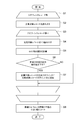
- FIG. 9 is a flowchart showing an example of a process of creating related geofence information by the related geofence information creating unit 11.
- the geofence information stored in the geofence information storage unit 10 is read out, and a loop process (S1 loop) for repeatedly performing the processes of S2 to S7 described below is executed for each record (step S1).
- S1 loop a loop process for repeatedly performing the processes of S2 to S7 described below is executed for each record.
- the calculation target record that is the target record of this loop is read from the geofence information read in S1 (step S2).
- the record of the geofence (point name, Lat, Lon, and radius) indicated by the calculation target record in the geofence information read in S1 is set as a new record of the related geofence information to be created. To do.
- step S3 loop a loop process (S3 loop) is repeatedly executed for each record other than the calculation target record in the geofence information read out in S1 (S3 loop) (step S3).
- the comparison target record which is the target record of this loop is read from the geofence information (except the calculation target record) read in S1 (step S4).
- the distance between the center of the geofence indicated by the calculation target record read in S2 and the center of the geofence indicated by the comparison target record read in S4 is calculated (step S5).
- step S6 whether the distance calculated in S5 is less than or equal to the absolute value of the difference between the radius of the geofence indicated by the calculation target record read in S2 and the radius of the geofence indicated by the comparison target record read in S4. It is determined (step S6).
- S6 the absolute value is less than or equal to the absolute value (S6: YES)
- S6: YES the absolute value
- the point name of the comparison target record is additionally associated with the new record of the related geofence information set in S2 as the point name of the related geofence (step S7).
- the process moves to the next loop in the S3 loop (the S3 loop is executed for the next comparison target record). After all the loops in the S3 loop are completed (after the S3 loop is executed for all the comparison target records), the process moves to the next loop in the S1 loop (the S1 loop is executed for the next calculation target record). To).
- step S8 the process of creating the related geofence information ends.
- the process of S8 may be omitted.
- FIG. 9 an example of creating related geofence information in which related geofences including all geographic ranges of the geofence are associated with each geofence is shown.
- an example of creating related geofence information that associates related geofences that are other geofences with each geofence, based on the distance from the geofence, and the geofence for each geofence. It is also possible to use as an example of creating related geofence information in which related geofences in which at least a part of the geographical ranges of the above are associated.
- the creation of the related geofence information by the related geofence information creation unit 11 may be performed regularly (for example, once a day) or irregularly based on an instruction from the administrator of the check-in determination device 1. May be carried out.
- the creation of the related geofence information by the related geofence information creating unit 11 is normally executed before the judgment, independently of the check-in judgment by the check-in judgment device 1 (the check-in judgment unit 14 thereof). . That is, the processing time for the check-in determination by (the check-in determination unit 14 of) the check-in determination device 1 is not affected by the processing time for the related geofence information creation unit 11 to create the related geofence information.
- the related geofence information creating unit 11 may create the related geofence information at the timing of the check-in determination by (the check-in determining unit 14 of) the check-in determination device 1.
- the related geofence information storage unit 12 stores related geofence information.
- the related geofence information storage unit 12 specifically stores the related geofence information created by the related geofence information creation unit 11.
- the position specifying information acquisition unit 13 acquires the position specifying information of the terminal 2.
- the position specifying information acquisition unit 13 specifically receives and acquires the position specifying information transmitted from each terminal 2.
- the position specifying information acquisition unit 13 may acquire the position specifying information (indirectly) not only from the terminal 2 but also from another device or a memory of the check-in determination device 1.
- the position identification information acquisition unit 13 outputs the acquired position identification information to the check-in determination unit 14.
- the check-in determination unit 14 sequentially determines the check-in of the terminal 2 for each geofence (of all preset / registered geofences). More specifically, the check-in determination unit 14 uses the geofence information stored by the geofence information storage unit 10 or the related geofence information stored by the related geofence information storage unit 12 and the position identification information acquisition unit 13. Based on the acquired (input) position specifying information, the position of the terminal 2 specified by the position specifying information is included one by one for each geofence included in the geofence information or the related geofence information. Check-in of the terminal 2 is determined by determining whether or not the check-in is performed.
- the check-in determination unit 14 determines that the terminal 2 has checked in to one geofence, the related geofence information stored by the related geofence information storage unit 12 is associated with the relevant geofence. Offenses will be excluded from the judgment in the subsequent judgments.
- the check-in determination unit 14 determines the check-in of the terminal 2. When it is determined that the terminal 2 has checked in to the geofence with the point name “zero” while being present, the related geofence “ichi” associated with the record with the point name “zero” in the related geofence information is identified.
- the geofence is excluded from the determination target in the subsequent determination by the check-in determination unit 14. If there are multiple related geofences associated with one geofence (the geofence identified by the point name “zero” in the above example), all of the multiple related geofences are subject to determination in the subsequent determination. Outside.
- the check-in determination unit 14 determines that the terminal 2 has checked in with respect to one geofence, it is associated with the one geofence in the related geofence information stored by the related geofence information storage unit 12. It may be determined that the terminal 2 has checked in with respect to the associated geofence as well. For example, in the example using FIG. 8 described above, it may be determined that the terminal 2 has checked in also to the geofence identified by the related geofence “ichi”. In addition, when there is a plurality of related geofences associated with one geofence (the geofence identified by the point name “zero” in the example using FIG. 8 described above), all of the plurality of related geofences are related. Alternatively, it may be determined that the terminal 2 has checked in.
- the check-in determination unit 14 may determine the check-in of the terminal 2 in ascending order of geographic range for each geofence. More specifically, the check-in determination unit 14 determines the check-in of the terminal 2 for each geofence of the geofence information or related geofence information sorted in advance in ascending order of geographic range. Alternatively, the check-in determination unit 14 may sort the geofences of the geofence information or the related geofence information in ascending order of the geographic range of each geofence, and then sort the geofences. The check-in of the terminal 2 may be determined in the order in which the check-in is performed.
- the check-in determination unit 14 After determining the check-in of the terminal 2, the check-in determination unit 14 transmits the determination result or information based on the determination result to the terminal 2, another function of the check-in determination device 1, or another device (output). ) May be.
- the determination result may include, for example, the UUID of the 2 concerned, the point name of the geofence that has determined the check-in, and the datetime that is the timing at which the position identification information of the terminal 2 that is the target of the check-in is acquired. Other information may be included.
- FIG. 10 is a flowchart showing an example of check-in determination processing by the check-in determination unit 14.
- the check-in determination unit 14 is the main body of the process unless otherwise specified.
- the position specifying information acquisition unit 13 acquires the position specifying information of the terminal 2 (step S10).
- the position identification information includes UUID, Lat, Lon, and datetime.
- a record of the related geofence information stored in the related geofence information storage unit 12 is extracted, and a loop process (S11 loop) for repeatedly performing the following processes of S11 to S15 is executed (step S11).
- S11 a loop process for repeatedly performing the following processes of S11 to S15 is executed.
- S11 the target record (geofence) that is the target record of this loop is read (step S12).
- the terminal 2 checks in the geofence indicated by the target record read in S12. It is determined whether or not (the terminal 2 is included in the geofence) (step S14). More specifically, the position indicated by Lat and Lon included in the position specifying information acquired in S10 is included in the circle centered on Lat and Lon of the target record and having the radius of the target record. Or not.
- the terminal 2 determines that the check-in is performed, and the related geofence associated with the target record read in S12 is determined to be checked-in.
- step S15 the determination result (for example, the UUID of the 2 concerned, the point name of the geofence for which the check-in is determined, and the datetime that is the timing for acquiring the position identification information of the terminal 2 that is the target of the check-in is included. Information) or information based on the determination result may be transmitted to the terminal 2, another function of the check-in determination device 1, or another device.
- the record of the related geofence information stored by the related geofence information storage unit 12 in the S11 loop has been described, but the present invention is not limited to this, and instead, the geofence information is used.
- a record of the geofence information stored by the storage unit 10 may be used.
- the related geofence information stored in the related geofence information storage unit 12 is referred to, and the related geofence corresponding to the target record is extracted.
- the related geofence information that stores the related geofence information in which the related geofence that is another geofence is associated with each geofence based on the distance from the geofence.
- the storage unit 12 is provided, and when the check-in determination unit 14 determines the check-in of the terminal 2 for each geofence in order and determines that the terminal 2 has checked in for one geofence, In the related geofence information stored in the related geofence information storage unit 12, the related geofence associated with the one geofence is excluded from the determination target in the subsequent determination.
- the related geofence associated with the one geofence based on the distance is excluded from the determination target. It This means that, for example, when the terminal 2 checks in to one geofence, the terminal 2 may also check in to a related geofence associated with the one geofence based on the distance. Since it is high, the judgment of the relevant geofence can be omitted. As described above, since it is possible to reduce the number of geofences that are the targets of check-in determination, check-in can be determined at a higher speed.
- the check-in determination device 1 of the present embodiment when the check-in determination unit 14 determines that the terminal 2 has checked in to one geofence, the related geofence information storage unit 12 stores it. It is also determined that the terminal 2 has checked in the related geofence associated with the one geofence in the related geofence information thus obtained. This means that, for example, when the terminal 2 checks in to one geofence, the terminal 2 may also check in to a related geofence associated with the one geofence based on the distance. Is high. In this way, the check-in determination for a plurality of geofences can be performed by the check-in determination for one geofence, so the check-in can be determined at a higher speed.
- a related geofence in which at least a part of the geofence of the geofence overlaps is associated with each geofence. This means that, for example, when the terminal 2 checks in to one geofence, the terminal 2 also checks in to a related geofence in which at least a part of the geofence of the one geofence overlaps. Based on the high probability that
- the related geofence information is associated with the related geofence that includes all the geographic ranges of the geofence for each geofence. This means that, for example, if the terminal 2 checks in for one geofence, the terminal 2 also checks in for related geofences that cover the entire geographical range of the one geofence. Based on that.
- the check-in determination unit 14 determines the check-in of terminals in the ascending order of geographic range for each geofence.
- a geofence that includes a geofence has a larger geographical range (wider) than the geofence. If terminal check-in is determined for each geofence in ascending geographic range, for example, it is possible to extract more related geofences that encompass all geographic ranges of each geofence earlier. As a result, more geofences can be excluded from the determination target (and / or the check-in determination is completed) at an earlier stage, so that the check-in determination can be performed at a higher speed.
- the related geofence information creation unit 11 that creates the related geofence information is provided, and the related geofence information storage unit 12 creates the related geofence information creation unit 11.
- the related geofence information that has been created is stored. Thereby, for example, the related geofence information can be created and stored more reliably at an arbitrary timing.
- the comparison is performed as follows, and it is determined that the one satisfying the condition is checked in. For example, when the Lat and Lon of the terminal are input, the distances from the Lat and Lon of each record related to Geopheons in the DB are calculated, and it is compared whether the radius is equal to or less than the radius of the geofence. Further, for example, when the SSID or BSSID related to the network communication of the terminal is input, it is compared whether or not the SSID or BSSID of each record regarding the geofence in the DB matches.
- the calculation amount corresponds to the number of input data times the number of records in the DB, and the exhaustive search is performed (because check-ins may be made to multiple geofences. Will be all records judgment). That is, in the conventional device, the amount of calculation becomes enormous, and it takes time to determine the check-in of the terminal.
- the check-in determination device 1 of the present embodiment determines whether or not overlapping geofences can be combined into one and reduces the number of determinations by merging. For example, when a check-in to a small geofence (circle) is determined, a geofence having an inclusive relationship also determines a check-in to a large geofence (circle) in conjunction with the check, and skips the determination.
- the check-in determination device 1 can determine check-in at higher speed.
- each functional block may be realized by using one device physically or logically coupled, or directly or indirectly (for example, two or more devices physically or logically separated). , Wired, wireless, etc.) and may be implemented using these multiple devices.
- the functional blocks may be realized by combining the one device or the plurality of devices with software.
- Functions include judgment, decision, judgment, calculation, calculation, processing, derivation, investigation, search, confirmation, reception, transmission, output, access, solution, selection, selection, establishment, comparison, assumption, expectation, and observation. Broadcasting, notifying, communicating, forwarding, configuration, reconfiguring, allocating, mapping, assigning, etc., but not limited to these. I can't.
- functional blocks (components) that function transmission are called a transmitting unit and a transmitter.
- the implementation method is not particularly limited.
- the check-in determination device 1 and the like according to the embodiment of the present disclosure may function as a computer that performs the check-in determination process of the present disclosure.
- FIG. 11 is a diagram illustrating an example of a hardware configuration of the check-in determination device 1 according to the embodiment of the present disclosure.
- the above-described check-in determination device 1 may be physically configured as a computer device including a processor 1001, a memory 1002, a storage 1003, a communication device 1004, an input device 1005, an output device 1006, a bus 1007, and the like.
- the word “device” can be read as a circuit, device, unit, or the like.
- the hardware configuration of the check-in determination device 1 may be configured to include one or a plurality of each device illustrated in FIG. 11, or may be configured not to include some devices.
- Each function in the check-in determination device 1 causes a predetermined software (program) to be loaded onto hardware such as the processor 1001 and the memory 1002, so that the processor 1001 performs an operation and controls communication by the communication device 1004. It is realized by controlling at least one of reading and writing of data in the memory 1002 and the storage 1003.
- the processor 1001 operates an operating system to control the entire computer, for example.
- the processor 1001 may be configured by a central processing unit (CPU) including an interface with peripheral devices, a control device, an arithmetic device, a register, and the like.
- CPU central processing unit
- the related geofence information creation unit 11, the position identification information acquisition unit 13, the check-in determination unit 14, and the like described above may be realized by the processor 1001.
- the processor 1001 reads a program (program code), software module, data, and the like from at least one of the storage 1003 and the communication device 1004 into the memory 1002, and executes various processes according to these.
- a program program that causes a computer to execute at least part of the operations described in the above-described embodiments is used.
- the related geofence information creation unit 11, the position identification information acquisition unit 13, and the check-in determination unit 14 may be realized by a control program stored in the memory 1002 and operating in the processor 1001, and also for other functional blocks. It may be realized similarly.
- the various processes described above are executed by one processor 1001, they may be executed simultaneously or sequentially by two or more processors 1001.
- the processor 1001 may be implemented by one or more chips.
- the program may be transmitted from the network via an electric communication line.
- the memory 1002 is a computer-readable recording medium, and is configured by at least one of, for example, ROM (Read Only Memory), EPROM (Erasable Programmable ROM), EEPROM (Electrically Erasable Programmable ROM), RAM (Random Access Memory), etc. May be done.
- the memory 1002 may be called a register, a cache, a main memory (main storage device), or the like.
- the memory 1002 can store an executable program (program code), a software module, or the like for implementing the wireless communication method according to the embodiment of the present disclosure.
- the storage 1003 is a computer-readable recording medium, for example, an optical disc such as a CD-ROM (Compact Disc ROM), a hard disc drive, a flexible disc, a magneto-optical disc (for example, a compact disc, a digital versatile disc, a Blu-ray disc). At least one of a (registered trademark) disk, a smart card, a flash memory (for example, a card, a stick, and a key drive), a floppy (registered trademark) disk, a magnetic strip, or the like may be used.
- the storage 1003 may be called an auxiliary storage device.
- the storage medium described above may be, for example, a database including at least one of the memory 1002 and the storage 1003, a server, or another appropriate medium.
- the communication device 1004 is hardware (transmission / reception device) for performing communication between computers via at least one of a wired network and a wireless network, and is also referred to as a network device, network controller, network card, communication module, or the like.
- the communication device 1004 includes, for example, a high frequency switch, a duplexer, a filter, a frequency synthesizer, and the like in order to realize at least one of frequency division duplex (FDD: Frequency Division Duplex) and time division duplex (TDD). May be composed of For example, the position specifying information acquisition unit 13 and the check-in determination unit 14 described above may be realized by the communication device 1004.
- FDD Frequency Division Duplex
- TDD time division duplex
- the input device 1005 is an input device (for example, a keyboard, a mouse, a microphone, a switch, a button, a sensor, etc.) that receives an input from the outside.
- the output device 1006 is an output device (for example, a display, a speaker, an LED lamp, etc.) that performs output to the outside.
- the input device 1005 and the output device 1006 may be integrated (for example, a touch panel).
- Each device such as the processor 1001 and the memory 1002 is connected by a bus 1007 for communicating information.
- the bus 1007 may be configured by using a single bus, or may be configured by using a different bus for each device.
- the check-in determination device 1 includes hardware such as a microprocessor, a digital signal processor (DSP), an ASIC (Application Specific Integrated Circuit), a PLD (Programmable Logic Device), and an FPGA (Field Programmable Gate Array). It may be configured to include, and a part or all of each functional block may be realized by the hardware.
- the processor 1001 may be implemented using at least one of these hardware.
- the notification of information is not limited to the aspect / embodiment described in the present disclosure, and may be performed using another method.
- Each aspect / embodiment described in the present disclosure includes LTE (Long Term Evolution), LTE-A (LTE-Advanced), SUPER 3G, IMT-Advanced, 4G (4th generation mobile communication system), 5G (5th generation mobile communication system). system), FRA (Future Radio Access), NR (new Radio), W-CDMA (registered trademark), GSM (registered trademark), CDMA2000, UMB (Ultra Mobile Broadband), IEEE 802.11 (Wi-Fi (registered trademark) )), IEEE 802.16 (WiMAX (registered trademark)), IEEE 802.20, UWB (Ultra-WideBand), Bluetooth (registered trademark), other systems using appropriate systems, and extensions based on these. It may be applied to at least one of the next-generation systems. Also, a plurality of systems may be combined and applied (for example, a combination of at least one of LTE and LTE-A and 5G).
- Information that has been input and output may be stored in a specific location (for example, memory), or may be managed using a management table. Information that is input / output can be overwritten, updated, or added. The output information and the like may be deleted. The input information and the like may be transmitted to another device.
- the determination may be performed based on a value represented by 1 bit (0 or 1), may be performed based on a Boolean value (Boolean: true or false), or may be compared by numerical values (for example, a predetermined value). (Comparison with value).
- the notification of the predetermined information (for example, the notification of “being X”) is not limited to the explicit notification, and is performed implicitly (for example, the notification of the predetermined information is not performed). Good.
- software, instructions, information, etc. may be sent and received via a transmission medium.
- the software uses a wired technology (coaxial cable, optical fiber cable, twisted pair, digital subscriber line (DSL: Digital Subscriber Line), etc.) and / or wireless technology (infrared, microwave, etc.) websites, When sent from a server, or other remote source, at least one of these wired and wireless technologies is included within the definition of transmission medium.
- wired technology coaxial cable, optical fiber cable, twisted pair, digital subscriber line (DSL: Digital Subscriber Line), etc.
- wireless technology infrared, microwave, etc.
- data, instructions, commands, information, signals, bits, symbols, chips, etc. that may be referred to throughout the above description include voltage, current, electromagnetic waves, magnetic fields or magnetic particles, optical fields or photons, or any of these. May be represented by a combination of
- system and “network” used in this disclosure are used interchangeably.
- information, parameters, etc. described in the present disclosure may be represented by using an absolute value, may be represented by using a relative value from a predetermined value, or by using other corresponding information. May be represented.
- MS Mobile Station
- UE User Equipment
- determining and “determining” as used in this disclosure may encompass a wide variety of actions.
- “Judgment” and “decision” are, for example, judgment, calculation, computing, processing, deriving, investigating, and looking up, search, inquiry. (Eg, searching in a table, database, or another data structure), ascertaining what is considered to be “judgment” and “decision” may be included.
- “decision” and “decision” include receiving (for example, receiving information), transmitting (for example, transmitting information), input, output, and access. (Accessing) (for example, accessing data in a memory) may be regarded as “judging” or “deciding”.
- judgment and “decision” means to consider that “resolving”, “selecting”, “choosing”, “establishing”, “comparing”, etc. May be included. That is, the “judgment” and “decision” may include considering some action as “judgment” and “decision”. In addition, “determination (decision)” may be read as “assuming,” “expecting,” “considering,” and the like.
- connection means any direct or indirect connection or coupling between two or more elements, and It can include the presence of one or more intermediate elements between two elements that are “connected” or “coupled”.
- the connections or connections between the elements may be physical, logical, or a combination thereof.
- connection may be read as “access”.
- two elements are in the radio frequency domain, with at least one of one or more wires, cables and printed electrical connections, and as some non-limiting and non-exhaustive examples. , Can be considered to be “connected” or “coupled” to each other, such as with electromagnetic energy having wavelengths in the microwave region and the light (both visible and invisible) region.
- the phrase “based on” does not mean “based only on,” unless expressly specified otherwise. In other words, the phrase “based on” means both "based only on” and “based at least on.”
- the term “A and B are different” may mean “A and B are different from each other”.
- the term may mean that “A and B are different from C”.
- the terms “remove”, “coupled” and the like may be construed as “different” as well.
Landscapes
- Engineering & Computer Science (AREA)
- Theoretical Computer Science (AREA)
- Business, Economics & Management (AREA)
- Computer Networks & Wireless Communication (AREA)
- Signal Processing (AREA)
- Tourism & Hospitality (AREA)
- Physics & Mathematics (AREA)
- General Physics & Mathematics (AREA)
- Economics (AREA)
- Health & Medical Sciences (AREA)
- General Engineering & Computer Science (AREA)
- General Health & Medical Sciences (AREA)
- Human Resources & Organizations (AREA)
- Marketing (AREA)
- Primary Health Care (AREA)
- Strategic Management (AREA)
- General Business, Economics & Management (AREA)
- Management, Administration, Business Operations System, And Electronic Commerce (AREA)
- Telephonic Communication Services (AREA)
- Information Retrieval, Db Structures And Fs Structures Therefor (AREA)
Abstract
L'invention concerne un dispositif 1 de détermination d'enregistrement d'arrivée servant à déterminer un enregistrement d'arrivée qui indique qu'un terminal 2 est entré dans une zone de géorepérage qui est une étendue géographique prescrite, le dispositif 1 de détermination d'enregistrement d'arrivée comportant: une unité 12 de stockage d'informations de zones de géorepérage apparentées servant à stocker des informations de zones de géorepérage apparentées dans lesquelles chaque zone de géorepérage est associée, sur la base de la distance à la zone de géorepérage, à des zones de géorepérage apparentées qui sont d'autres zones de géorepérage; et une unité 14 de détermination d'enregistrement d'arrivée servant à déterminer l'enregistrement d'arrivée d'un terminal 2 dans l'ordre pour chaque zone de géorepérage. Lorsqu'il est déterminé que le terminal 2 s'est enregistré à l'arrivée dans une zone de géorepérage, l'unité 14 de détermination d'enregistrement d'arrivée exclut, parmi des objets pour lesquels une détermination est effectuée ultérieurement, une zone de géorepérage apparentée associée à la zone de géorepérage considérée dans les informations de zones de géorepérage apparentées stockées par l'unité 12 de stockage d'informations de zones de géorepérage apparentées.
Priority Applications (2)
| Application Number | Priority Date | Filing Date | Title |
|---|---|---|---|
| JP2020552530A JP7328985B2 (ja) | 2018-10-18 | 2019-07-22 | チェックイン判定装置 |
| US17/281,843 US11812326B2 (en) | 2018-10-18 | 2019-07-22 | Check-in determining device |
Applications Claiming Priority (2)
| Application Number | Priority Date | Filing Date | Title |
|---|---|---|---|
| JP2018196594 | 2018-10-18 | ||
| JP2018-196594 | 2018-10-18 |
Publications (1)
| Publication Number | Publication Date |
|---|---|
| WO2020079907A1 true WO2020079907A1 (fr) | 2020-04-23 |
Family
ID=70283027
Family Applications (1)
| Application Number | Title | Priority Date | Filing Date |
|---|---|---|---|
| PCT/JP2019/028707 WO2020079907A1 (fr) | 2018-10-18 | 2019-07-22 | Dispositif de détermination d'enregistrement d'arrivée |
Country Status (3)
| Country | Link |
|---|---|
| US (1) | US11812326B2 (fr) |
| JP (1) | JP7328985B2 (fr) |
| WO (1) | WO2020079907A1 (fr) |
Citations (2)
| Publication number | Priority date | Publication date | Assignee | Title |
|---|---|---|---|---|
| JP2017084411A (ja) * | 2013-06-28 | 2017-05-18 | グーグル インコーポレイテッド | モバイルデバイスのためのジオフェンスを基にした警告のクラスタ化 |
| WO2018066251A1 (fr) * | 2016-10-07 | 2018-04-12 | シャープ株式会社 | Dispositif de traitement d'informations, procédé de commande de dispositif de traitement d'informations, et programme de commande |
Family Cites Families (21)
| Publication number | Priority date | Publication date | Assignee | Title |
|---|---|---|---|---|
| US20130275198A1 (en) * | 2010-08-23 | 2013-10-17 | MobileBits Corporation | System and methods for delivering targeted marketing content to mobile device users based on geolocation |
| US10878439B2 (en) * | 2012-06-11 | 2020-12-29 | Retailmenot, Inc. | Mobile-offer creation |
| US9432806B2 (en) * | 2012-12-04 | 2016-08-30 | Ebay Inc. | Dynamic geofence based on members within |
| US9311685B2 (en) * | 2013-03-14 | 2016-04-12 | Bank Of America Corporation | Geolocation check-in system |
| US9288620B2 (en) * | 2014-04-01 | 2016-03-15 | Qualcomm Incorporated | Reducing overlapping geofences |
| US10832285B2 (en) * | 2014-04-24 | 2020-11-10 | At&T Intellectual Property I, L.P. | Mobile coupon discounts and valuation based on probability of a geofence collision |
| US10003925B1 (en) * | 2014-04-30 | 2018-06-19 | Marvell International Ltd. | Low-power device positioning method using position updates calculated by low power processor |
| US11606666B2 (en) * | 2014-07-29 | 2023-03-14 | GeoFrenzy, Inc. | Global registration system for aerial vehicles |
| US20220044533A1 (en) * | 2014-07-29 | 2022-02-10 | GeoFrenzy, Inc. | Systems and methods for geofence security |
| US20160116274A1 (en) * | 2014-10-27 | 2016-04-28 | At&T Mobility Ii Llc | Mobility based location determination |
| JP2017034371A (ja) * | 2015-07-30 | 2017-02-09 | 富士通株式会社 | 電子機器及び情報通知プログラム |
| US10034129B1 (en) * | 2015-08-24 | 2018-07-24 | Groupon, Inc. | Mobile proximity based messages |
| US20170116651A1 (en) * | 2015-10-26 | 2017-04-27 | International Business Machines Corporation | Method and system for location tracking in absence of network connectivity |
| US10064005B2 (en) * | 2015-12-09 | 2018-08-28 | Hand Held Products, Inc. | Mobile device with configurable communication technology modes and geofences |
| US20180033024A1 (en) * | 2016-07-28 | 2018-02-01 | Cisco Technology, Inc. | Behavioral Analytic System |
| US10939229B2 (en) * | 2017-04-24 | 2021-03-02 | International Business Machines Corporation | Cognitive geofence based notification |
| US10397395B2 (en) * | 2017-05-17 | 2019-08-27 | Microsoft Technology Licensing, Llc | Departure or entry intent-based reminders |
| GB2560392B (en) * | 2017-07-05 | 2019-08-21 | Wearable Link Ltd | Geofencing system |
| DE112017007742T8 (de) * | 2017-07-14 | 2021-04-01 | Fujitsu Limited | Informationsverarbeitungsvorrichtung, Informationsbereitstellungsverfahren undInformationsbereitstellungssystem |
| US20190313204A1 (en) * | 2018-04-09 | 2019-10-10 | Blackberry Limited | Method and system for generation of geofence shape |
| US20210127225A1 (en) * | 2018-05-28 | 2021-04-29 | Here Global B.V. | Complex geofence definition |
-
2019
- 2019-07-22 JP JP2020552530A patent/JP7328985B2/ja active Active
- 2019-07-22 WO PCT/JP2019/028707 patent/WO2020079907A1/fr active Application Filing
- 2019-07-22 US US17/281,843 patent/US11812326B2/en active Active
Patent Citations (2)
| Publication number | Priority date | Publication date | Assignee | Title |
|---|---|---|---|---|
| JP2017084411A (ja) * | 2013-06-28 | 2017-05-18 | グーグル インコーポレイテッド | モバイルデバイスのためのジオフェンスを基にした警告のクラスタ化 |
| WO2018066251A1 (fr) * | 2016-10-07 | 2018-04-12 | シャープ株式会社 | Dispositif de traitement d'informations, procédé de commande de dispositif de traitement d'informations, et programme de commande |
Also Published As
| Publication number | Publication date |
|---|---|
| US11812326B2 (en) | 2023-11-07 |
| JP7328985B2 (ja) | 2023-08-17 |
| US20220030378A1 (en) | 2022-01-27 |
| JPWO2020079907A1 (ja) | 2021-09-09 |
Similar Documents
| Publication | Publication Date | Title |
|---|---|---|
| JP2015092160A (ja) | WiFi情報を利用した位置情報提供方法および装置 | |
| JP6609723B2 (ja) | 目的地推定装置 | |
| US11805393B2 (en) | Method for aggregation and calculation of a population distribution of devices over a predetermined geographic area | |
| WO2020075364A1 (fr) | Dispositif de détermination de vérification | |
| US12048027B2 (en) | Device management system | |
| WO2019216046A1 (fr) | Dispositif de traitement d'informations | |
| WO2020079907A1 (fr) | Dispositif de détermination d'enregistrement d'arrivée | |
| CN108882165B (zh) | 一种导航方法和装置 | |
| WO2020213612A1 (fr) | Dispositif de prévision de la demande | |
| US11895559B2 (en) | Moving means determination device | |
| JP6788530B2 (ja) | 発信器検知システム、発信器検知プログラム、移動端末及び発信器検知端末プログラム | |
| JP7366767B2 (ja) | 情報提供装置 | |
| JP7397738B2 (ja) | 集計装置 | |
| US11785651B2 (en) | Device management system | |
| JP7323370B2 (ja) | 審査装置 | |
| JP6807799B2 (ja) | サーバ | |
| JP6677601B2 (ja) | 翻訳システム | |
| JP2020064394A (ja) | 経済指標算出装置、経済指標算出方法、及び経済指標算出プログラム | |
| JP2018077669A (ja) | 訪問先推定装置 | |
| WO2024047978A1 (fr) | Dispositif de détermination de magasin | |
| JP7295023B2 (ja) | ユーザ属性推定システム | |
| WO2024111207A1 (fr) | Dispositif d'estimation de valeur d'attribut | |
| JP6948221B2 (ja) | 在宅率推定装置 | |
| WO2018216413A1 (fr) | Dispositif d'estimation de solitude | |
| JP2021114030A (ja) | 駐車場管理装置および駐車場管理システム |
Legal Events
| Date | Code | Title | Description |
|---|---|---|---|
| 121 | Ep: the epo has been informed by wipo that ep was designated in this application |
Ref document number: 19874305 Country of ref document: EP Kind code of ref document: A1 |
|
| ENP | Entry into the national phase |
Ref document number: 2020552530 Country of ref document: JP Kind code of ref document: A |
|
| NENP | Non-entry into the national phase |
Ref country code: DE |
|
| 122 | Ep: pct application non-entry in european phase |
Ref document number: 19874305 Country of ref document: EP Kind code of ref document: A1 |