WO2015004855A1 - ナビゲーション装置、シミュレーション装置、移動装置およびナビゲーション方法 - Google Patents
ナビゲーション装置、シミュレーション装置、移動装置およびナビゲーション方法 Download PDFInfo
- Publication number
- WO2015004855A1 WO2015004855A1 PCT/JP2014/003250 JP2014003250W WO2015004855A1 WO 2015004855 A1 WO2015004855 A1 WO 2015004855A1 JP 2014003250 W JP2014003250 W JP 2014003250W WO 2015004855 A1 WO2015004855 A1 WO 2015004855A1
- Authority
- WO
- WIPO (PCT)
- Prior art keywords
- information
- destination
- value
- terrain
- unit
- Prior art date
Links
- 238000000034 method Methods 0.000 title claims description 57
- 238000004088 simulation Methods 0.000 title claims description 24
- 238000004364 calculation method Methods 0.000 claims description 54
- 238000001514 detection method Methods 0.000 claims description 16
- 238000010219 correlation analysis Methods 0.000 claims description 6
- 239000000284 extract Substances 0.000 claims description 3
- 239000011159 matrix material Substances 0.000 description 42
- 230000000875 corresponding effect Effects 0.000 description 16
- 230000036544 posture Effects 0.000 description 13
- 238000010586 diagram Methods 0.000 description 12
- 238000005265 energy consumption Methods 0.000 description 10
- 239000013598 vector Substances 0.000 description 6
- 239000011435 rock Substances 0.000 description 3
- 238000012876 topography Methods 0.000 description 3
- 238000004590 computer program Methods 0.000 description 2
- 230000002596 correlated effect Effects 0.000 description 2
- 230000007423 decrease Effects 0.000 description 2
- 238000005516 engineering process Methods 0.000 description 2
- 230000001133 acceleration Effects 0.000 description 1
- 230000001174 ascending effect Effects 0.000 description 1
- 239000000470 constituent Substances 0.000 description 1
- 238000010276 construction Methods 0.000 description 1
- 230000001276 controlling effect Effects 0.000 description 1
- 238000005314 correlation function Methods 0.000 description 1
- 230000000694 effects Effects 0.000 description 1
- 238000005401 electroluminescence Methods 0.000 description 1
- 239000000446 fuel Substances 0.000 description 1
- 239000004973 liquid crystal related substance Substances 0.000 description 1
- 238000005259 measurement Methods 0.000 description 1
Images


Classifications
-
- G—PHYSICS
- G05—CONTROLLING; REGULATING
- G05D—SYSTEMS FOR CONTROLLING OR REGULATING NON-ELECTRIC VARIABLES
- G05D1/00—Control of position, course, altitude or attitude of land, water, air or space vehicles, e.g. using automatic pilots
- G05D1/02—Control of position or course in two dimensions
- G05D1/021—Control of position or course in two dimensions specially adapted to land vehicles
- G05D1/0231—Control of position or course in two dimensions specially adapted to land vehicles using optical position detecting means
-
- G—PHYSICS
- G01—MEASURING; TESTING
- G01C—MEASURING DISTANCES, LEVELS OR BEARINGS; SURVEYING; NAVIGATION; GYROSCOPIC INSTRUMENTS; PHOTOGRAMMETRY OR VIDEOGRAMMETRY
- G01C21/00—Navigation; Navigational instruments not provided for in groups G01C1/00 - G01C19/00
- G01C21/26—Navigation; Navigational instruments not provided for in groups G01C1/00 - G01C19/00 specially adapted for navigation in a road network
- G01C21/34—Route searching; Route guidance
- G01C21/3453—Special cost functions, i.e. other than distance or default speed limit of road segments
-
- G—PHYSICS
- G01—MEASURING; TESTING
- G01C—MEASURING DISTANCES, LEVELS OR BEARINGS; SURVEYING; NAVIGATION; GYROSCOPIC INSTRUMENTS; PHOTOGRAMMETRY OR VIDEOGRAMMETRY
- G01C21/00—Navigation; Navigational instruments not provided for in groups G01C1/00 - G01C19/00
- G01C21/10—Navigation; Navigational instruments not provided for in groups G01C1/00 - G01C19/00 by using measurements of speed or acceleration
- G01C21/12—Navigation; Navigational instruments not provided for in groups G01C1/00 - G01C19/00 by using measurements of speed or acceleration executed aboard the object being navigated; Dead reckoning
- G01C21/14—Navigation; Navigational instruments not provided for in groups G01C1/00 - G01C19/00 by using measurements of speed or acceleration executed aboard the object being navigated; Dead reckoning by recording the course traversed by the object
-
- G—PHYSICS
- G01—MEASURING; TESTING
- G01S—RADIO DIRECTION-FINDING; RADIO NAVIGATION; DETERMINING DISTANCE OR VELOCITY BY USE OF RADIO WAVES; LOCATING OR PRESENCE-DETECTING BY USE OF THE REFLECTION OR RERADIATION OF RADIO WAVES; ANALOGOUS ARRANGEMENTS USING OTHER WAVES
- G01S19/00—Satellite radio beacon positioning systems; Determining position, velocity or attitude using signals transmitted by such systems
- G01S19/38—Determining a navigation solution using signals transmitted by a satellite radio beacon positioning system
- G01S19/39—Determining a navigation solution using signals transmitted by a satellite radio beacon positioning system the satellite radio beacon positioning system transmitting time-stamped messages, e.g. GPS [Global Positioning System], GLONASS [Global Orbiting Navigation Satellite System] or GALILEO
- G01S19/42—Determining position
-
- G—PHYSICS
- G05—CONTROLLING; REGULATING
- G05D—SYSTEMS FOR CONTROLLING OR REGULATING NON-ELECTRIC VARIABLES
- G05D1/00—Control of position, course, altitude or attitude of land, water, air or space vehicles, e.g. using automatic pilots
- G05D1/0088—Control of position, course, altitude or attitude of land, water, air or space vehicles, e.g. using automatic pilots characterized by the autonomous decision making process, e.g. artificial intelligence, predefined behaviours
Definitions
- the present invention relates to a navigation device, a simulation device, a moving device, and a navigation method.
- Non-Patent Document 1 describes an autonomous mobile robot that can autonomously move from a predetermined start point to a goal point.
- the autonomous mobile robot of Non-Patent Document 1 performs route planning using self-position estimation and map construction even if no prior information such as obstacles is given. However, when there is no prior information on the movement route, the autonomous mobile robot of Non-Patent Document 1 is likely to encounter a dead end on the movement route. In this case, the autonomous mobile robot must turn back and cannot move efficiently to the goal point.
- An object of the present invention is to provide a navigation device capable of efficiently moving a mobile device to a destination even when there is no prior information on the travel route, a mobile device including the navigation device, and a navigation method.
- Another object of the present invention is used to estimate the value of a moving route to a destination in a navigation device that can efficiently move the moving device to the destination even when there is no prior information on the moving route.
- a simulation apparatus capable of creating weight information.
- a navigation device is a navigation device mounted on a mobile device, and includes a travel route detection unit that detects one or a plurality of travel routes that can be moved by the mobile device, and the mobile device as a reference.
- a destination location information acquisition unit for acquiring information on the location of the selected destination as destination location information
- a terrain feature information acquisition unit for acquiring information on terrain features around the mobile device as terrain feature information
- Weight information for calculating, as value correlation information, information that includes a plurality of weighting factors respectively corresponding to position information and terrain feature information and correlates with values from the destination position information and terrain feature information to the destination of the travel route.
- the destination location information and the terrain feature acquired by the destination location information acquisition unit Based on the storage unit to be stored and the weight information stored in the storage unit, the destination location information and the terrain feature acquired by the destination location information acquisition unit. From the topographic feature information acquired by the information acquisition unit, value correlation information to the destination for one or a plurality of movement routes detected by the movement route detection unit is calculated, and one or more based on the calculated value correlation information A value estimation unit that estimates the value of the plurality of travel routes to the destination.
- this navigation device one or a plurality of movement paths through which the moving device can move are detected. Further, destination position information related to the position of the destination with reference to the mobile device is acquired. Topographic feature information regarding the features of the topography around the mobile device is acquired.
- Weight information for calculating value correlation information correlating with the value from the destination position information and topographic feature information to the destination of the travel route is stored in advance.
- the weight information includes a plurality of weight coefficients respectively corresponding to the destination position information and the terrain feature information.
- value correlation information from the acquired destination position information and terrain feature information to the destination for one or more detected travel routes is calculated. Based on the calculated value correlation information, the value to the destination of one or a plurality of travel routes is estimated.
- This configuration makes it possible to estimate the value of one or more travel routes to the destination even when there is no prior information on the travel route.
- the moving device can reach the destination with a high probability by moving the moving route estimated to have high value.
- the navigation device can efficiently move the mobile device to the destination even when there is no prior information on the travel route.
- a plurality of weighting factors in the weight information are a plurality of destination position information related to the position of an arbitrary destination on the basis of an arbitrary point in a virtual terrain including a plurality of movement routes, and surroundings of the arbitrary point It may be calculated by canonical correlation analysis using a plurality of pieces of terrain feature information related to the features of the terrain and values acquired in advance of a plurality of travel routes.
- the plurality of destination position information, the plurality of terrain feature information, and the value of the plurality of travel routes to the destination are acquired using a virtual terrain including the plurality of travel routes. This makes it easy to obtain multiple destination location information, multiple terrain feature information, and multiple travel route destination values for any terrain, and easily calculate the weighting factor for any terrain. can do.
- a plurality of destination position information related to the position of an arbitrary destination on the basis of an arbitrary point in a virtual landform including a plurality of movement routes, and a plurality of topographic feature information related to features of the topography around the arbitrary point Is set as a plurality of first variables, and a first function including a plurality of first coefficients respectively corresponding to the plurality of first variables is set, and destinations of a plurality of movement paths in the virtual landform
- a second function including one or more second coefficients corresponding to each of the one or more second variables is set, wherein The plurality of first coefficient values and the one or more second coefficient values are determined so that the correlation between the value and the value of the second function is maximized.
- the value of 1 coefficient is set to multiple weighting factors It may also include a.
- the reliability of the value correlation information to the destination for one or a plurality of moving routes calculated from the destination position information and the terrain feature information in the actual moving route Will improve.
- the reliability of the value to the destination of the estimated one or a plurality of moving routes can be improved.
- the navigation device may further include a route selection unit that selects a travel route having the highest value among the values estimated by the value estimation unit.
- the moving device moves along the movement route estimated to have the highest value.
- the mobile device can reach the destination through the best travel path.
- the navigation device can move the mobile device to the destination more efficiently even when there is no prior information on the movement route.
- the navigation device further includes an operation unit that is operated by a user to designate a destination position, and a position and orientation sensor that receives positioning information of the mobile device from the global positioning system.
- the information acquisition unit may acquire the destination position information based on the position of the destination specified by the operation unit and the positioning information of the mobile device received by the position and orientation sensor. In this case, the destination position information can be acquired easily and accurately.
- the navigation device further includes an environment recognition sensor that surveys a first number of points around the mobile device, and the movement path detection unit is a first corresponding to each of the first number of points by the environment recognition sensor. Detecting one or a plurality of movement paths on which the mobile device can move based on the information of the number of surveys, and the terrain feature information acquisition unit determines the first number of information on the one or more movement paths from the information of the first number of surveys.
- the survey information of the second number smaller than the number of 1 may be extracted as the topographic feature information.
- the number of the plurality of topographic feature information is reduced from the first number to the second number.
- the value to the destination of one or a plurality of movement routes can be estimated at high speed without greatly reducing the reliability.
- the environment recognition sensor may include a laser range finder.
- the first number of points can be surveyed with a simple configuration.
- the high value of the travel route to the destination may include a short travel time when the mobile device travels the travel route.
- the navigation device can move the moving device to the destination in a short time.
- the high value of the moving route to the destination may include a small amount of energy consumed when the moving device moves on the moving route.
- the navigation device can move the moving device to the destination with less energy consumption.
- a simulation device is a simulation device that creates weight information used to estimate the value of a moving route to a destination in a navigation device according to one aspect of the present invention.
- a storage unit for storing terrain data indicating a virtual terrain including a moving path of the vehicle, and a virtual moving device capable of traveling on a plurality of moving paths in the virtual terrain indicated by the terrain data stored in the storage unit; , Acquire the value of multiple travel routes by moving the mobile device from any point in the virtual terrain to any destination, and to any destination based on the value of the multiple travel routes acquired
- a value calculation unit that calculates the value of the optimal travel route, and a plurality of locations related to the position of an arbitrary destination on the basis of an arbitrary point in virtual terrain.
- Weight information for calculating value correlation information correlating to the value of the travel route to the destination is calculated by canonical correlation analysis
- a weight information calculation unit that includes a plurality of weight coefficients respectively corresponding to the destination position information and the terrain feature information.
- terrain data indicating a virtual terrain including a plurality of movement paths is stored.
- the virtual moving device can travel on a plurality of moving paths in the virtual terrain indicated by the stored terrain data.
- the value of multiple travel routes is acquired by moving the mobile device from an arbitrary point on the virtual terrain to an arbitrary destination, and based on the acquired values of the multiple travel routes, The value of the optimal travel route is calculated.
- a plurality of destination position information related to the position of an arbitrary destination based on an arbitrary point in the virtual landform and a plurality of topographic feature information related to the features of the terrain around the arbitrary point are acquired.
- Value correlation information that correlates to the value of the travel route to the destination based on the value of the optimal travel route calculated for each of the multiple destinations and the acquired multiple destination location information and multiple topographic feature information Is calculated by canonical correlation analysis.
- the weight information includes a plurality of weight coefficients respectively corresponding to the destination position information and the terrain feature information.
- weight information calculated by the simulation device is stored. Based on the stored weight information, value correlation information from the acquired destination position information and terrain feature information to the destination for one or more detected travel routes is calculated. Based on the calculated value correlation information, the value to the destination of one or a plurality of travel routes is estimated.
- This configuration makes it possible to estimate the value of one or more travel routes to the destination even when there is no prior information on the travel route.
- the moving device can reach the destination with a high probability by moving the moving route estimated to have high value.
- the navigation device can efficiently move the mobile device to the destination even when there is no prior information on the travel route.
- the simulation device uses weight information used to estimate the value of the travel route to the destination in the navigation device that can efficiently move the travel device to the destination even when there is no prior information of the travel route. Can be created.
- An autonomous mobile device includes a main body configured to be movable, a navigation device according to one aspect of the present invention mounted on the main body, and each movement estimated by the navigation device. And a control unit that controls the movement of the main body based on the value of the route to the destination.
- the above navigation device is mounted on the main body.
- the main body moves based on the value to the destination of each movement route estimated by the navigation device. According to this configuration, since the autonomous mobile device includes the navigation device described above, it is possible to efficiently move to the destination even when there is no prior information on the travel route.
- a navigation method is a navigation method for navigating a mobile device, and includes a plurality of weighting factors respectively corresponding to destination position information and terrain feature information. Pre-stores weight information for calculating value correlation information as information correlating with the value from the topographic feature information to the destination of the travel route, and detecting one or a plurality of travel routes on which the mobile device can move
- one or a plurality of movement paths through which the moving device can move are detected. Further, destination position information related to the position of the destination with reference to the mobile device is acquired. Topographic feature information regarding the features of the topography around the mobile device is acquired.
- Weight information for calculating value correlation information correlating with the value from the destination position information and topographic feature information to the destination of the travel route is stored in advance.
- the weight information includes a plurality of weight coefficients respectively corresponding to the destination position information and the terrain feature information.
- value correlation information from the acquired destination position information and terrain feature information to the destination for one or more detected travel routes is calculated. Based on the calculated value correlation information, the value to the destination of one or a plurality of travel routes is estimated.
- This configuration makes it possible to estimate the value of one or more travel routes to the destination even when there is no prior information on the travel route.
- the moving device can reach the destination with a high probability by moving the moving route estimated to have high value.
- the navigation method can efficiently move the mobile device to the destination even when there is no prior information on the travel route.
- the present invention it is possible to efficiently move the mobile device to the destination even when there is no prior information on the travel route. Also, creating weight information used to estimate the value of a moving route to a destination in a navigation device that can efficiently move the moving device to the destination even when there is no prior information of the moving route Is possible.
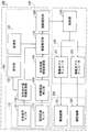
- FIG. 1 is a block diagram showing an example of the configuration of a mobile device according to an embodiment of the present invention.
- FIG. 2 is a schematic diagram showing the appearance of the moving device.
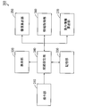
- FIG. 3 is a block diagram showing an example of the configuration of the simulation apparatus according to the embodiment of the present invention.
- FIG. 4 is a diagram showing a virtual terrain used for the route setting process.
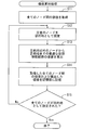
- FIG. 5 is a flowchart showing the route setting process.
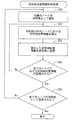
- FIG. 6 is a flowchart showing value calculation processing by the value calculation unit.
- FIG. 7 is a flowchart showing destination position information acquisition processing by the information acquisition unit.
- FIG. 8 is a diagram for explaining the r component, h component, and ⁇ component of the destination position information.
- FIG. 1 is a block diagram showing an example of the configuration of a mobile device according to an embodiment of the present invention.
- FIG. 2 is a schematic diagram showing the appearance of the moving device.
- FIG. 3 is a block diagram showing an example of the configuration of the simulation
- FIG. 9 is a flowchart showing the terrain feature information acquisition processing by the information acquisition unit.
- FIG. 10 is a diagram for explaining the f1 to f16 components of the topographic feature information.
- FIG. 11 is a flowchart showing weight information calculation processing by the weight information calculation unit.
- FIG. 12 is a flowchart showing navigation processing by the navigation device.
- FIG. 13 is a flowchart showing navigation processing by the navigation device.
- the mobile device is an autonomous mobile device that does not require driving and operation by a driver used in an agricultural work site or a disaster site.
- FIG. 1 is a block diagram showing an example of the configuration of a mobile device according to an embodiment of the present invention.
- FIG. 2 is a schematic diagram showing the appearance of the moving device.
- FIG. 2A shows a plan view of the moving device
- FIG. 2B shows a side view of the moving device.
- the moving device 200 includes a navigation device 100, a control unit 210, an actuator unit 220, a moving mechanism unit 230, a vehicle body 240, and wheels 250 (FIG. 2).
- mobile device 200 is a UGV (unmanned land vehicle) including four wheels 250.
- UGV unmanned land vehicle
- the navigation device 100 includes a sensor unit 110, an operation unit 120, and a storage unit 130.
- the navigation device 100 includes a destination position information acquisition unit 140, a movement route detection unit 150, a terrain feature information acquisition unit 160, a value estimation unit 170, and a route selection unit 180.
- the destination position information acquisition unit 140, the movement route detection unit 150, the terrain feature information acquisition unit 160, the value estimation unit 170, and the route selection unit 180 are realized by, for example, a CPU (Central Processing Unit) and a computer program.
- a CPU Central Processing Unit
- the sensor unit 110 includes a position and orientation sensor 111 and an environment recognition sensor 112.
- the position / orientation sensor 111 receives positioning information and attitude information of the moving device 200 from GPS (Global Positioning System), INS (Inertial Navigation Device), and IMU (Inertial Attitude Measurement Device).
- the positioning information includes the position, speed, and acceleration of the mobile device 200.
- the posture information includes the direction of the vehicle body 240.
- the position / orientation sensor 111 provides the received position information and orientation information of the mobile device 200 to the destination position information acquisition unit 140.
- the environment recognition sensor 112 is, for example, an LRF (laser range finder). As shown in FIG. 2B, the environment recognition sensor 112 sequentially emits a plurality (32 in this example) of laser beams in the vertical direction of the moving device 200 at predetermined angular intervals. In this state, as shown in FIG. 2A, the environment recognition sensor 112 rotates about the vertical direction of the vehicle body 240 as an axis. Thereby, the environment recognition sensor 112 sequentially emits a plurality of laser beams around the vehicle body 240 at predetermined angular intervals.
- LRF laser range finder
- the environment recognition sensor 112 measures a plurality of points around the mobile device 200 by detecting light reflected by surrounding objects.
- the environment recognition sensor 112 emits about 64000 laser beams per second around the vehicle body 240. Therefore, the environment recognition sensor 112 measures 64,000 points around the mobile device 200.
- the environment recognition sensor 112 provides survey information of a plurality of points to the movement path detection unit 150.
- the 1 includes a user interface.
- the user can designate the position of the destination by operating the operation unit 120.
- the operation unit 120 provides the destination position information acquisition unit 140 with the position of the destination designated by the user.
- the destination position information acquisition unit 140 estimates the position and posture of the mobile device 200 based on the positioning information and posture information of the mobile device 200. Further, the destination position information acquisition unit 140 acquires the position of the destination with reference to the moving device 200 as destination position information based on the estimated position of the moving device 200 and the position of the designated destination. .
- the destination position information has three dimensions. The destination position information acquisition unit 140 provides the destination position information to the value estimation unit 170.
- the movement path detection unit 150 detects one or a plurality of movement paths on which the movement device 200 can move based on survey information of a plurality of points by the environment recognition sensor 112.
- the movement route detection unit 150 provides the detected movement route to the terrain feature information acquisition unit 160.
- the terrain feature information acquisition unit 160 selects survey information on a moving route from survey information of a plurality of points by the environment recognition sensor 112 and extracts it as terrain feature information.
- the terrain feature information indicates features of the terrain around the mobile device 200.
- the topographic feature information of 16 places on the movement route is extracted from the survey information of 64000 places. That is, the terrain feature information has 16 dimensions.
- the terrain feature information acquisition unit 160 provides the terrain feature information to the value estimation unit 170.
- the storage unit 130 is, for example, a hard disk.
- the storage unit 130 stores weight information in advance.
- the weight information includes a plurality of weight coefficients respectively corresponding to the destination position information and the terrain feature information.
- the weight information is information that associates the destination position information and the terrain feature information with the weight correlation information correlated with the value of the moving route to the destination.
- the value estimation unit 170 acquires weight information stored in the storage unit 130.
- the value of the travel route to the destination may be travel time or energy consumption.
- the navigation device 100 can move the mobile device 200 to the destination in a short time by selecting a travel route having high value.
- the navigation device 100 can move the mobile device 200 to the destination with less energy consumption by selecting a high-value travel route.
- the value estimation unit 170 calculates, as value correlation information, information that correlates with the value of one or more travel routes to the destination based on the weight information. Moreover, the value estimation part 170 estimates the value to the destination of one or several moving routes based on the calculated value correlation information. The value estimation unit 170 gives the route selection unit 180 the value to the destination of one or more travel routes.
- the route selection unit 180 selects a travel route having the highest value among the values estimated by the value estimation unit 170.
- the route selection unit 180 gives information indicating the selected movement route to the control unit 210.
- the control unit 210 is, for example, an ECU (electronic control unit).
- the actuator unit 220 includes a drive system actuator 221 and a steering system actuator 222.
- the moving mechanism unit 230 includes a drive mechanism 231 and a steering mechanism 232.
- the drive mechanism 231 includes, for example, a throttle valve and a brake.
- the steering mechanism 232 includes, for example, steering.
- the drive system actuator 221 and the steering system actuator 222 are connected to the drive mechanism 231 and the steering mechanism 232, respectively.
- the control unit 210 controls the drive system actuator 221 and the steering system actuator 222 so that the moving device 200 moves along the movement route selected by the route selection unit 180.
- the drive system actuator 221 adjusts, for example, the throttle valve opening and the brake operation amount of the drive mechanism 231 based on control by the control unit 210.
- the steering system actuator 222 operates the steering of the steering mechanism 232, for example. Accordingly, the moving device 200 can move to the destination through the moving route selected by the route selecting unit 180.
- the moving device 200 moves on the moving route estimated to have the highest value.
- the moving apparatus 200 can reach the destination through the best moving path.
- the navigation device 100 can move the mobile device 200 more efficiently to the destination even when there is no advance information on the travel route.
- FIG. 3 is a block diagram showing an example of the configuration of the simulation apparatus according to the embodiment of the present invention.
- the simulation apparatus 300 includes an operation unit 310, a display unit 320, a storage unit 330, a route setting unit 340, a value calculation unit 350, an information acquisition unit 360, and a weight information calculation unit 370.
- the route setting unit 340, the value calculation unit 350, the information acquisition unit 360, and the weight information calculation unit 370 are realized by a CPU and a computer program, for example.
- the operation unit 310 includes a keyboard and a pointing device.
- the user can give various instructions to the route setting unit 340 by operating the operation unit 310.
- the display unit 320 is, for example, a liquid crystal display panel or an organic EL (electroluminescence) display panel.
- the storage unit 330 is, for example, a hard disk.
- the storage unit 330 stores terrain data and moving device data in advance.
- the storage unit 330 stores in advance a route setting program, a value calculation program, a destination position information acquisition program, a terrain feature information acquisition program, and a weight information calculation program.
- the terrain data is data for displaying a virtual terrain (hereinafter referred to as a virtual terrain) including a plurality of moving paths and obstacles such as plants and rocks on the display unit 320.
- a virtual terrain including a plurality of moving paths and obstacles such as plants and rocks on the display unit 320.
- the terrain data it is preferable to use terrain data having a virtual terrain similar to the terrain on which the mobile device 200 actually travels.
- the mobile device data is data for displaying a virtual mobile device (hereinafter referred to as a virtual mobile device) corresponding to the mobile device 200 of FIG.
- the route setting unit 340 displays the virtual moving device and the virtual landform on the display unit 320 based on the operation of the operation unit 310 by the user.
- the moving device data includes the sensor unit 110, the actuator unit 220, the moving mechanism unit 230, and the vehicle body 240 in FIG. 1, and the virtual sensor unit, the actuator unit, the moving mechanism unit, the vehicle body, and the wheels corresponding to the wheel 250 in FIG. It consists of data to be displayed on the display unit 320.
- the virtual moving device can travel on a plurality of moving paths in virtual terrain by driving a virtual actuator unit and a moving mechanism unit.
- the route setting unit 340 sets a combination of a plurality of moving routes in the virtual terrain on which the virtual moving device moves by executing route setting processing described later.
- the route setting unit 340 stores the set combination of travel routes in the storage unit 330.
- the value calculating unit 350 moves the virtual moving device from an arbitrary point on the virtual terrain to an arbitrary destination by executing a value calculating process described later based on the terrain data and the moving device data. Thereby, the value calculation part 350 acquires the value of a several movement path
- the information acquisition unit 360 executes a destination position information acquisition process to be described later on the basis of the terrain data and the mobile device data, thereby performing a plurality of purposes related to the position of an arbitrary destination on the basis of an arbitrary point on the virtual terrain. Get location information.
- the information acquisition unit 360 executes a terrain feature information acquisition process to be described later based on the terrain data and the mobile device data, thereby obtaining a plurality of terrain feature information related to the features of the terrain around any point in the virtual terrain. get.
- the information acquisition unit 360 stores the acquired plurality of destination position information and the plurality of terrain feature information in the storage unit 330.
- the weight information calculation unit 370 calculates weight information based on the value to the destination of the plurality of travel routes, the plurality of destination position information, and the plurality of topographic feature information by executing a weight information calculation process described later. To do.
- the weight information is information for calculating value correlation information that correlates with the value of the travel route to the destination, and the weight information is calculated by canonical correlation analysis.
- the weight information calculation unit 370 stores the calculated weight information in the storage unit 330.
- the weight information stored in the storage unit 330 is stored in the storage unit 130 of the mobile device 200.
- FIG. 4 is a diagram showing a virtual landform used for the route setting process.
- the virtual landform 10 includes a plurality of virtual moving paths 11 to which the virtual moving device can move and virtual obstacles 12 such as plants and rocks to which the virtual moving device cannot move.
- the virtual movement path 11 and the virtual obstacle 12 are referred to as a virtual movement path 11 and a virtual obstacle 12, respectively.
- the virtual movement path 11 is indicated by white
- the virtual obstacle 12 is indicated by a dot pattern.
- the illustration of the height difference of the virtual landform 10 is omitted.
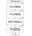
- FIG. 5 is a flowchart showing the route setting process.
- the route setting process is performed when the CPU of the simulation apparatus 300 executes a route setting program.
- the user operates the operation unit 310 to select the terrain data stored in the storage unit 330.
- the route setting unit 340 displays the virtual terrain 10 on the display unit 320 based on the selected terrain data (step S1).
- the route setting unit 340 sets a plurality of nodes 13 in a plurality of portions on the virtual movement route 11 (step S2).
- the number of nodes 13 to be set is N.
- the path setting unit 340 sets a combination of the virtual movement paths 11 along which the virtual movement apparatus moves by linking the set arbitrary nodes 13 (step S3). Thereafter, the route setting unit 340 stores the set combination of the plurality of nodes and the virtual movement route 11 in the storage unit 330 (step S4).
- step S2 83 nodes 13 are set in step S2.
- the number of combinations of the virtual movement paths 11 from one node 13 to another node 13 as the destination is N ⁇ (N ⁇ 1).
- N the number of combinations of the virtual movement paths 11 from one node 13 to another node 13 as the destination.
- step S3 combinations of 9378 types of virtual movement paths 11 are set in step S3. After the route setting process, each of the value calculation process, the destination position information acquisition process, and the topographic feature information acquisition process is continued.
- FIG. 6 is a flowchart showing value calculation processing by the value calculation unit 350.
- the value calculation process is performed by the CPU of the simulation apparatus 300 executing a value calculation program.
- the value calculation unit 350 acquires the value between all the nodes 13 by causing the virtual mobile device to travel between all the nodes 13 (step S11).
- the value between the nodes 13 is the movement time of the virtual moving device when moving between the nodes 13.
- the value between the nodes 13 may be the fuel consumption rate of the virtual moving device when moving between the nodes 13.
- the value calculation unit 350 sets an arbitrary node 13 as a destination (step S12). Subsequently, the value calculation unit 350 calculates the optimum value of the virtual movement route 11 from the node 13 other than the destination to the destination (step S13). Value is calculated by the DP method (dynamic programming). Thereafter, the value calculation unit 350 stores the acquired values between all the nodes 13 and the calculated values in the storage unit 330 (step S14).
- step S15 determines whether or not all the nodes 13 have been set as destinations.
- step S15 when all the nodes 13 are not set as the destination, the value calculation unit 350 returns to the process of step S12. Thereby, the processing of steps S12 to S15 is repeated.
- step S15 the value calculation unit 350 ends the value calculation process.
- step S11 the value between the nodes 13 is acquired based on the moving speed of the virtual mobile device. For example, when the unevenness between certain nodes 13 is large, the moving speed of the virtual moving device decreases. Therefore, the value between the nodes 13 becomes low.
- the attitude of the virtual mobile device is taken into account when acquiring the value between the nodes 13.
- the movement speed of the virtual moving device decreases when moving from one node 13 to the other node 13.
- the moving speed of the virtual moving device increases. Therefore, the value between the nodes 13 when moving from one node 13 to the other node 13 is low, and the value between the nodes 13 when moving from the other node 13 to one node 13 is high.
- FIG. 7 is a flowchart showing destination position information acquisition processing by the information acquisition unit 360.
- the destination position information acquisition process is performed by the CPU of the simulation apparatus 300 executing a destination position information acquisition program.
- the information acquisition unit 360 sets an arbitrary node 13 as a destination (step S21).
- the information acquisition unit 360 calculates destination position information in the nodes 13 other than the destination (step S22).
- the destination position information is calculated based on the positioning information obtained by the position and orientation sensor of the sensor unit of the virtual moving device.
- the destination position information is composed of three components (an r component, an h component, and a ⁇ component described later). That is, the destination position information has three dimensions.
- the information acquisition unit 360 stores the calculated destination position information in the storage unit 330 (step S23). Thereafter, the information acquisition unit 360 determines whether or not the destination position information for all nodes 13 other than the destination is stored in the storage unit 330 (step S24). In step S24, when the destination position information for all the nodes 13 other than the destination is not stored in the storage unit 330, the information acquisition unit 360 returns to the process of step S22. Thereby, the processing of steps S22 to S24 is repeated.
- step S24 when the destination position information for all the nodes 13 other than the destination is stored in the storage unit 330 in step S24, the information acquisition unit 360 determines whether all the nodes 13 are set as the destinations. (Step S25). In step S25, when all the nodes 13 are not set as the destination, the information acquisition unit 360 returns to the process of step S21. Thereby, the processing of steps S21 to S25 is repeated. On the other hand, when all the nodes 13 are set as destinations in step S25, the information acquisition unit 360 ends the destination position information acquisition process.
- FIG. 8 is a diagram for explaining the r component, h component, and ⁇ component of the destination position information.
- FIG. 8A shows a side view of a part of the virtual terrain 10
- FIG. 8B shows a plan view of a part of the virtual terrain 10.
- the node 13G is set as the destination. Attention is paid to the node 13A as a node 13 other than the node 13G.
- the horizontal distance from the node 13A to the node 13G is the r component of the destination position information at the node 13A.
- the vertical distance from the node 13A to the node 13G is the h component of the destination position information at the node 13A.
- an angle formed by a line segment from the node 13A toward the other node 13 other than the destination and a line segment from the node 13A toward the node 13G is the ⁇ component of the destination position information at the node 13A.
- nodes 13B and 13C are set as the nodes 13 adjacent to the node 13A.
- the angle formed by the line segment from the node 13A to the node 13B and the line segment from the node 13A to the node 13G is ⁇ 1, and is formed by the line segment from the node 13A to the node 13C and the line segment from the node 13A to the node 13G.
- the angle is ⁇ 2.
- the angle ⁇ 1 becomes the ⁇ component of the destination position information at the node 13A.
- the angle ⁇ 2 becomes the ⁇ component of the destination position information at the node 13A.
- the ⁇ component of the destination position information of each node 13 varies depending on the movement path of the virtual movement apparatus.
- FIG. 9 is a flowchart showing the terrain feature information acquisition process by the information acquisition unit 360.
- the terrain feature information acquisition process is performed by the CPU of the simulation apparatus 300 executing a terrain feature information acquisition program.
- the information acquisition unit 360 calculates terrain feature information at an arbitrary node 13 (step S31).
- the topographic feature information is composed of 16 components (components f1 to f16 described later). That is, the destination position information has 16 dimensions.
- the information acquisition unit 360 stores the calculated topographic feature information in the storage unit 330 (step S32). Subsequently, the information acquisition unit 360 determines whether or not the terrain feature information for all the nodes 13 is stored in the storage unit 330 (step S33). In step S33, when the terrain feature information for all the nodes 13 is not stored in the storage unit 330, the information acquisition unit 360 returns to the process of step S31. Thereby, the processing of steps S31 to S33 is repeated. On the other hand, when the terrain feature information in all the nodes 13 is stored in the storage unit 330 in step S33, the information acquisition unit 360 ends the terrain feature information acquisition process.
- FIG. 10 is a diagram for explaining the f1 to f16 components of the topographic feature information.
- FIG. 10A shows a plan view of a part of the virtual terrain 10
- FIG. 10B shows a side view of a part of the virtual terrain 10.
- attention is paid to the node 13A as the arbitrary node 13.
- FIG. The virtual mobile device 1 is arranged at the node 13A in a posture facing the traveling direction.
- laser light is emitted from the environment recognition sensor of the sensor unit of the virtual moving device 1 within a range of 180 ° in front of the virtual moving device 1. Further, the laser light reflected by the object around the virtual moving device 1 is detected by the environment recognition sensor.
- the object includes the ground and obstacles such as plants and rocks.
- the position closest to the virtual moving device 1 is P1
- the position farthest from the virtual moving device 1 is P2.
- Laser beams L1 to L16 reflected by the objects at 16 positions that divide the distance between the positions P1 and P2 into 15 equal parts are extracted.
- the distances to the objects measured by the laser beams L1 to L16 are d1 to d16, respectively.
- a plurality of laser beams reflected by a plurality of objects near the distance d1 are detected.
- the average value of the distances to the plurality of objects measured by the plurality of laser beams is the f1 component of the topographic feature information.
- a plurality of laser beams respectively reflected by a plurality of objects near the distance d2 are detected.
- the average value of the distances to the plurality of objects surveyed by the plurality of laser beams becomes the f2 component of the topographic feature information.
- a plurality of laser beams respectively reflected by a plurality of objects near the distance d3 are detected.
- the average value of the distances to the plurality of objects measured by the plurality of laser beams is the f3 component of the topographic feature information.
- a plurality of laser beams respectively reflected by a plurality of objects near the distances d4 to d16 are detected.
- the average values of the distances to the plurality of objects measured by the plurality of laser beams corresponding to the distances d4 to d16 are the f4 to f16 components of the topographic feature information, respectively.
- step S31 the terrain feature information having 16 components in the node 13A when the virtual mobile device 1 is in one posture is calculated. That is, the terrain feature information having a large number of components (64,000 in this example) is reduced in dimension to the terrain feature information having 16 components.
- step S31 the terrain feature information in the node 13A when the virtual moving device 1 is in another posture is calculated.
- the weight information calculation unit 370 executes the weight information calculation process after the value calculation process, the destination position information acquisition process, and the topographic feature information acquisition process.
- FIG. 11 is a flowchart showing weight information calculation processing by the weight information calculation unit 370. The weight information calculation process is performed when the CPU of the simulation apparatus 300 executes a weight information calculation program.
- the weight information calculation unit 370 sets the first function in the plurality of virtual movement routes 11 set by the route setting unit 340 (step S41).
- the first function includes a plurality of first variables and a plurality of first coefficients.
- the plurality of first variables include a plurality of destination position information and a plurality of topographic feature information.
- the plurality of first coefficients correspond to the plurality of first variables, respectively.
- the first function x is given by the following formula (1).
- the first function x is a product of the first coefficient matrix a and the first variable matrix X.
- the first coefficient matrix a is a data matrix of 1 row ⁇ p columns.
- the first coefficient matrix a includes p first coefficients.
- p is an integer of 2 or more.
- the first coefficient matrix a includes 19 first coefficients a1, a2, a3,.
- the first variable matrix X is a data matrix of p rows ⁇ n columns.
- p is an integer indicating the number of first coefficients
- n is an integer indicating the number of combinations of the virtual movement paths 11. In this example, p is 19 and n is 9378.
- Each column of the first variable matrix X includes p first variables.
- each column includes p first variables r (i) , h (i) , ⁇ (i) , f1 (i) to f16 (i) .
- i is an integer of 1 to n.
- the r variable, h component and ⁇ component of the destination position information corresponding to the i-th virtual movement path 11 and the f1 to f16 components of the topographic feature information are p first variables r (i). , H (i) , ⁇ (i) , f1 (i) to f16 (i) .
- the plurality of first coefficients a1, a2, a3,..., A19 of the first coefficient matrix a are the plurality of first variables r (i) , h in each column of the first variable matrix X. This corresponds to (i) , ⁇ (i) , f1 (i) to f16 (i) , respectively.
- the weight information calculation unit 370 sets the second function in the plurality of virtual movement routes 11 set by the route setting unit 340 (step S42).
- the second function includes one or more second variables and one or more second coefficients.
- the one or more second variables include the value of the optimal virtual movement path 11 to the destination.
- the one or more second coefficients correspond to one or more second variables, respectively.
- the second function y is a product of the second coefficient matrix b and the second variable matrix Y.
- the second coefficient matrix b is a data matrix of 1 row ⁇ q columns.
- q is 1. Therefore, the second coefficient matrix b includes only one second coefficient, and the second coefficient matrix b is equal to the second coefficient b.
- the second variable matrix Y is a data matrix of q rows ⁇ n columns.
- n is an integer indicating the number of combinations of the virtual movement paths 11. In this example, q is 1 and n is 9378.
- Each row (in this example, one row) of the second variable matrix Y includes n second variables.
- each row includes n second variables v (1) , v (2) , v (3) ,..., V (n) .
- the value v corresponding to the i-th virtual movement path 11 corresponds to the second variable v (i) .
- i is an integer of 1 to n.
- the weight information calculation unit 370 sets the values of the plurality of first coefficients and the value of one or more second coefficients so that the correlation between the first function x and the second function y is maximized. Determine (step S43).
- step S43 the values of the first coefficients a1, a2, a3,..., A19 and the values of the second coefficient matrix b (values of the second coefficient b) of the plurality of first coefficient matrices a are as follows. ).
- covariance matrices S XX , S YY , and S YX given by the following formulas (3), (4), and (5) are calculated.
- the superscript “T” represents a transposed matrix.
- X ⁇ is an average deviation matrix obtained by subtracting the average value of the components in the row direction of the first variable matrix X from the components in the row direction of the first variable matrix X.
- Y ⁇ is an average deviation matrix obtained by subtracting the average value of the components in the row direction of the second variable matrix Y from the components in the row direction of the second variable matrix Y.
- the function r (a, b) is a correlation function obtained by linearly combining the first coefficient matrix a, the second coefficient matrix b, the first variable matrix X, and the second variable matrix Y.
- a first coefficient matrix a and a second coefficient matrix b that maximize the function r (a, b) are first canonical correlation vectors, and are denoted by A and B, respectively.
- the first canonical correlation vector A of the above equation (7) includes p first weighting coefficients A1, A2, A3,.
- First variable matrix X m in the above equation include p number of first variables r, h, theta, the f1 ⁇ f16.
- the first variables r, h, and ⁇ correspond to the r component, h component, and ⁇ component of the destination position information, and the first variables f1 to f16 correspond to the f1 to f16 components of the topographic feature information.
- the first canonical correlation vector B includes q (one in this example) second weighting coefficients B.
- the first variable matrix Y m in the above equation includes q (one in this example) second variables v.
- the second variable v corresponds to the value v.
- the value of the first function x m when the values are substituted into the first variables r, h, ⁇ , f1,..., F16 in the equation (7) represents the height of the value v.
- the value of the first function x m correspond to the value correlation information to the destination.
- the weight information calculation unit 370 stores the determined values of the plurality of first coefficients in the storage unit 330 as the plurality of weight coefficients A1 to A19 (step S44).
- the determined values of the plurality of first coefficients (the plurality of weighting coefficients A1 to A19) become the weight information. Thereby, the terrain feature information acquisition process ends.
- the plurality of destination position information, the plurality of terrain feature information, and the value to the destination of the plurality of travel routes are acquired using the virtual terrain 10 including the plurality of travel routes. This makes it easy to obtain multiple destination location information, multiple terrain feature information, and multiple travel route destination values for any terrain, and easily calculate the weighting factor for any terrain. can do.
- FIGS. 12 and 13 are flowcharts showing navigation processing by the navigation device 100.
- the navigation process is performed by the CPU of the navigation device 100 executing a navigation program.
- the mobile device 200 is arranged at a farm work site or a disaster site that is actually used.
- the storage unit 130 stores the weight information calculated in step S44 of the weight information calculation process.
- the user operates the operation unit 120 to specify the destination position in advance.
- the destination position information acquisition unit 140 sets the position of the designated destination (step S51).
- the control unit 210 of the moving device 200 drives the moving mechanism unit 230 by controlling the actuator unit 220. Thereby, the movement of the moving apparatus 200 starts.
- the destination position information acquisition unit 140 acquires positioning information and posture information from the position and orientation sensor 111 (step S52).
- the destination position information acquisition unit 140 estimates the position and posture of the mobile device 200 based on the acquired positioning information and posture information (step S53). Further, the destination position information acquisition unit 140 is based on the position of the moving device 200 and the position of the destination, and destination position information (r component, h component, and ⁇ component) regarding the position of the destination with reference to the moving device 200. ) Is acquired (step S54).
- the movement path detection unit 150 acquires survey information of a plurality of points from the environment recognition sensor 112 (step S55).
- the movement route detection unit 150 detects a movement route on which the movement device 200 can move based on the acquired survey information of the plurality of points (step S56).
- the topographic feature information acquisition unit 160 extracts the topographic feature information (components f1 to f16) from the survey information of a plurality of points by the environment recognition sensor 112 (step S57).
- Three components (r component, h component, and ⁇ component) of the destination position information acquired in step S54 and 16 components (f1 to f16 components) of the topographic feature information extracted in step S57 are expressed by the equation (7).
- the procedure for extracting the terrain feature information is the same as the procedure for extracting the f1 to f16 components of the 16 terrain feature information from the terrain feature information having 64000 components in FIGS. 10 (a) and 10 (b).
- the value estimation part 170 can estimate the value to the destination of one or several moving routes at high speed, without reducing reliability significantly.
- the value estimation unit 170 estimates the value to the destination of one or more travel routes (step S58).
- the estimation of the value of the movement route to the destination is correlated with the value of the one or more movement routes to the destination based on the weight information stored in the storage unit 130 from the destination position information and the terrain feature information. This is done by calculating value correlation information.
- the weight information stored in the storage unit 130 is the first canonical correlation vector A (a plurality of weighting coefficients A1 to A19) of Expression (7)
- the value correlation information to the destination is Expression (7).
- a first function x m Accordingly, based on equation (7), for one or more movement path, by the value of the first function x m is calculated from the first canonical correlation vector A and the first variable matrix X m, mobile The value v to the destination of the route is estimated.
- the route selection unit 180 selects the travel route having the highest value among the values estimated by the value estimation unit 170 (step S59).
- the control unit 210 moves along the movement route specified by the route selection unit 180.
- the destination position information acquisition unit 140 determines whether or not the position of the moving device 200 is the position of the destination (step S60).
- step S60 when the position of the moving device 200 is not the destination position, the CPU returns to the process of step S52. Thereby, the processing of steps S52 to S60 is repeated. On the other hand, if the position of the mobile device 200 is the destination position in step S60, the CPU ends the navigation process.
- one or a plurality of movement paths are detected by movement path detection unit 150.
- Destination position information (r component, h component, and ⁇ component) is acquired by the destination position information acquisition unit 140.
- Topographic feature information (components f1 to f16) is acquired by the topographic feature information acquisition unit 160.
- Weight information (first canonical correlation vector A including a plurality of weight coefficients A1 to A19) is stored in advance in the storage unit 130.
- value correlation information to the destination of the detected one or more movement path (the value of the first function x m) is calculated by the value estimating unit 170.
- the value estimator 170 estimates the value v up to the destination of one or more travel routes based on the calculated value correlation information.
- the moving device 200 can reach the destination with a high probability by moving the moving route estimated to have high value. As a result, the navigation device 100 can efficiently move the moving device 200 to the destination even when there is no prior information on the moving route.
- the value calculation unit 350 calculates the value of the optimal travel route for each of the plurality of destinations in the virtual landform 10.
- a plurality of destination position information and a plurality of terrain feature information in the virtual terrain 10 are acquired by the information acquisition unit 360.
- Weight information is calculated by the weight information calculation unit 370 based on the acquired values of the plurality of travel routes to the destination, the acquired plurality of destination position information, and the plurality of topographic feature information.
- the weight information used to estimate the value of the travel route to the destination in the navigation device 100 that can efficiently move the mobile device 200 to the destination. Can be created.
- the value of the travel route to the destination is travel time or energy consumption, but is not limited thereto.
- the value of the travel route to the destination may be travel time and energy consumption. In this case, the shorter the travel time when the mobile device 200 travels the travel route and the less the energy consumption, the higher the value to the destination of the travel route. Therefore, the navigation device 100 can move the mobile device 200 to the destination in a short time and with less energy consumption by selecting a travel route having high value.
- Equation (2) when the value to the destination of the movement route includes a plurality of elements, the second function y set by the weight information calculation unit 370 of the simulation apparatus 300 in the weight information calculation process is expressed by Equation (2). Instead, it is given by the following formula (9). Further, the second function y m having the maximum correlation with the first function x m of the equation (7) is given by the following equation (10) instead of the equation (8).
- v1 and v2 are the values of the optimum virtual movement route to the destination corresponding to the movement time and energy consumption, respectively.
- the route selection unit 180 selects the travel route having the highest value among the values estimated by the value estimation unit 170, but is not limited thereto. If the selected travel route is a dead end, the mobile device 200 returns to the branch point of the previous travel route.
- the route selection unit 180 may select a travel route having a value other than the highest value (for example, the second highest value) among the values estimated by the value estimation unit 170.
- the number of components of the topographic feature information is reduced to 16 components, but the present invention is not limited to this. Many components of the terrain feature information may be reduced to 15 or less components. In this case, the value estimation unit 170 can estimate the value of one or a plurality of travel routes to the destination more quickly. Alternatively, many components of the terrain feature information may be reduced to 17 or more components. In this case, the value estimation unit 170 can estimate the value to the destination of one or more travel routes more accurately.
- the moving device 200 is a four-wheeled vehicle, but is not limited to this.
- the moving device 200 may be another moving device such as a two-wheeled vehicle, a three-wheeled vehicle, a ship, or a walking robot.
- the mobile device 200 is an example of a mobile device or an autonomous mobile device
- the navigation device 100 is an example of a navigation device
- the movement route detection unit 150 is an example of a movement route detection unit.
- the destination location information acquisition unit 140 is an example of a destination location information acquisition unit
- the terrain feature information acquisition unit 160 is an example of a terrain feature information acquisition unit
- the storage unit 130 is an example of a storage unit of a navigation device
- the value estimation unit 170 is an example of a value estimation unit.
- the component in the column direction of the first variable matrix X is an example of the first variable
- the component in the row direction of the first coefficient matrix a is an example of the first coefficient
- the first function x is the first variable.
- the component in the column direction of the second variable matrix Y is an example of the second variable
- the component in the row direction of the second coefficient matrix b is an example of the second coefficient
- the second function Y is the second variable Y. This is an example of the function.
- the route selection unit 180 is an example of a route selection unit
- the operation unit 120 is an example of an operation unit
- the position and orientation sensor 111 is an example of a position and orientation sensor
- the environment recognition sensor 112 is an example of an environment recognition sensor.
- the storage unit 330 is an example of a storage unit of a simulation device
- the virtual movement device 1 is an example of a virtual movement device
- the value calculation unit 350 is an example of a value calculation unit
- the information acquisition unit 360 is an information acquisition unit. It is an example.
- the weight information calculation unit 370 is an example of a weight information calculation unit
- the vehicle body 240 is an example of a main body unit
- the control unit 210 is an example of a control unit.
- the present invention can be effectively used for various autonomous mobile bodies equipped with a navigation device.
Landscapes
- Engineering & Computer Science (AREA)
- Radar, Positioning & Navigation (AREA)
- Remote Sensing (AREA)
- Physics & Mathematics (AREA)
- General Physics & Mathematics (AREA)
- Automation & Control Theory (AREA)
- Aviation & Aerospace Engineering (AREA)
- Electromagnetism (AREA)
- Business, Economics & Management (AREA)
- Health & Medical Sciences (AREA)
- Artificial Intelligence (AREA)
- Evolutionary Computation (AREA)
- Game Theory and Decision Science (AREA)
- Medical Informatics (AREA)
- Computer Networks & Wireless Communication (AREA)
- Navigation (AREA)
- Traffic Control Systems (AREA)
Abstract
移動装置を基準とした目的地の位置に関する目的地位置情報および移動装置の周囲の地形の特徴に関する地形特徴情報が取得される。記憶部に目的地位置情報および地形特徴情報から移動経路の目的地までの価値に相関する価値相関情報を算出するための重み情報が記憶される。重み情報、目的地位置情報および地形特徴情報に基づいて一または複数の移動経路についての目的地までの価値相関情報が算出される。価値相関情報に基づいて一または複数の移動経路の目的地までの価値が推定される。
Description
本発明は、ナビゲーション装置、シミュレーション装置、移動装置およびナビゲーション方法に関する。
農作業場または災害現場等においては、運転手による運転および操作を必要としない自律式の移動装置が用いられることがある。このような移動装置には、移動経路の事前情報がない状況でも、任意の地点から目的地まで自律的に移動可能であることが求められる。非特許文献1には、事前に決められたスタート地点からゴール地点まで自律移動可能な自律移動ロボットが記載されている。
齋藤哲平・黒田洋司著「未知環境におけるFast SLAMに基づいた大域的経路計画法」、明治大学理工学部研究報告、明治大学理工学部、2009年3月31日、第40巻、p.1-8
非特許文献1の自律移動ロボットは、障害物等の事前情報が一切与えられていなくても、自己位置推定および地図構築を利用して経路計画を行う。しかしながら、移動経路の事前情報がない場合には、非特許文献1の自律移動ロボットは移動経路上の行き止まりに遭遇する可能性が高い。この場合、自律移動ロボットは引き返さなければならず、ゴール地点まで効率よく移動することができない。
本発明の目的は、移動経路の事前情報がない場合でも、移動装置を目的地まで効率よく移動させることが可能なナビゲーション装置、それを備えた移動装置およびナビゲーション方法を提供することである。
本発明の他の目的は、移動経路の事前情報がない場合でも、移動装置を目的地まで効率よく移動させることが可能なナビゲーション装置において移動経路の目的地までの価値を推定するために用いられる重み情報を作成可能なシミュレーション装置を提供することである。
(1)本発明の一局面に従うナビゲーション装置は、移動装置に搭載されるナビゲーション装置であって、移動装置が移動可能な一または複数の移動経路を検出する移動経路検出部と、移動装置を基準とした目的地の位置に関する情報を目的地位置情報として取得する目的地位置情報取得部と、移動装置の周囲の地形の特徴に関する情報を地形特徴情報として取得する地形特徴情報取得部と、目的地位置情報および地形特徴情報にそれぞれ対応する複数の重み係数を含み目的地位置情報および地形特徴情報から移動経路の目的地までの価値に相関する情報を価値相関情報として算出するための重み情報を予め記憶する記憶部と、記憶部に記憶された重み情報に基づいて、目的地位置情報取得部により取得された目的地位置情報および地形特徴情報取得部により取得された地形特徴情報から、移動経路検出部により検出された一または複数の移動経路についての目的地までの価値相関情報を算出し、算出された価値相関情報に基づいて一または複数の移動経路の目的地までの価値を推定する価値推定部とを備えるものである。
このナビゲーション装置においては、移動装置が移動可能な一または複数の移動経路が検出される。また、移動装置を基準とした目的地の位置に関する目的地位置情報が取得される。移動装置の周囲の地形の特徴に関する地形特徴情報が取得される。
目的地位置情報および地形特徴情報から移動経路の目的地までの価値に相関する価値相関情報を算出するための重み情報が予め記憶されている。ここで、重み情報は、目的地位置情報および地形特徴情報にそれぞれ対応する複数の重み係数を含む。
記憶された重み情報に基づいて、取得された目的地位置情報および地形特徴情報から、検出された一または複数の移動経路についての目的地までの価値相関情報が算出される。算出された価値相関情報に基づいて一または複数の移動経路の目的地までの価値が推定される。
この構成によれば、移動経路の事前情報がない場合でも、一または複数の移動経路の目的地までの価値を推定することができる。移動装置は、高い価値を有すると推定された移動経路を移動することにより、高い確率で目的地に到達することができる。それにより、ナビゲーション装置は、移動経路の事前情報がない場合でも、移動装置を目的地まで効率よく移動させることが可能になる。
(2)重み情報における複数の重み係数は、複数の移動経路を含む仮想的な地形において、任意の地点を基準とした任意の目的地の位置に関する複数の目的地位置情報、任意の地点の周囲の地形の特徴に関する複数の地形特徴情報、および複数の移動経路の予め取得した価値を用いて、正準相関分析により算出されてもよい。
この場合、複数の目的地位置情報、複数の地形特徴情報および複数の移動経路の目的地までの価値は、複数の移動経路を含む仮想的な地形を用いて取得される。これにより、任意の地形の複数の目的地位置情報、複数の地形特徴情報および複数の移動経路の目的地までの価値を容易に取得することができるとともに、任意の地形の重み係数を容易に算出することができる。
(3)複数の移動経路を含む仮想的な地形における任意の地点を基準とした任意の目的地の位置に関する複数の目的地位置情報および任意の地点の周囲の地形の特徴に関する複数の地形特徴情報を複数の第1の変数として含みかつ複数の第1の変数にそれぞれ対応する複数の第1の係数を含む第1の関数が設定されるとともに、仮想的な地形における複数の移動経路の目的地までの価値を一または複数の第2の変数として含みかつ一または複数の第2の変数にそれぞれ対応する一または複数の第2の係数を含む第2の関数が設定され、第1の関数の値と第2の関数の値との相関が最大となるように複数の第1の係数の値および一または複数の第2の係数の値が決定され、重み情報は、決定された複数の第1の係数の値を複数の重み係数として含んでもよい。
この場合、決定された第1の係数を用いることにより、実際の移動経路における目的地位置情報および地形特徴情報から算出される一または複数の移動経路についての目的地までの価値相関情報の信頼性が向上する。これにより、推定される一または複数の移動経路の目的地までの価値の信頼性を向上させることができる。
(4)ナビゲーション装置は、価値推定部により推定された価値のうち、最も高い価値を有する移動経路を選択する経路選択部をさらに備えてもよい。
この場合、移動装置は、最も高い価値を有すると推定された移動経路を移動する。それにより、移動装置は最良の移動経路を通って目的地に到達することができる。その結果、ナビゲーション装置は、移動経路の事前情報がない場合でも、移動装置を目的地までより効率よく移動させることが可能になる。
(5)ナビゲーション装置は、目的地の位置を指定するために使用者により操作される操作部と、全地球測位システムから移動装置の測位情報を受信する位置姿勢センサとをさらに備え、目的地位置情報取得部は、操作部により指定された目的地の位置と、位置姿勢センサにより受信された移動装置の測位情報とに基づいて目的地位置情報を取得してもよい。この場合、目的地位置情報を容易かつ正確に取得することができる。
(6)ナビゲーション装置は、移動装置の周囲における第1の数の地点を測量する環境認識センサをさらに備え、移動経路検出部は、環境認識センサによる第1の数の地点にそれぞれ対応する第1の数の測量の情報に基づいて移動装置が移動可能な一または複数の移動経路を検出し、地形特徴情報取得部は、第1の数の測量の情報から一または複数の移動経路上における第1の数よりも少ない第2の数の測量の情報を地形特徴情報として抽出してもよい。
この場合、複数の地形特徴情報の数が第1の数から第2の数に低次元化される。これにより、信頼性を大きく低下させることなく一または複数の移動経路の目的地までの価値を高速に推定することができる。
(7)環境認識センサはレーザレンジファインダを含んでもよい。この場合、簡単な構成で第1の数の地点を測量することができる。
(8)移動経路の目的地までの価値の高さは、移動装置が移動経路を移動する際の移動時間の短さを含んでもよい。この場合、ナビゲーション装置は、移動装置を目的地まで短時間で移動させることが可能になる。
(9)移動経路の目的地までの価値の高さは、移動装置が移動経路を移動する際の消費エネルギーの少なさを含んでもよい。この場合、ナビゲーション装置は、移動装置を目的地まで少ない消費エネルギーで移動させることが可能になる。
(10)本発明の他の局面に従うシミュレーション装置は、本発明の一局面に従うナビゲーション装置において移動経路の目的地までの価値を推定するために用いられる重み情報を作成するシミュレーション装置であって、複数の移動経路を含む仮想的な地形を示す地形データを記憶する記憶部と、記憶部に記憶された地形データにより示される仮想的な地形における複数の移動経路を走行可能な仮想的な移動装置と、仮想的な地形における任意の地点から任意の目的地まで移動装置を移動させることにより複数の移動経路の価値を取得し、取得された複数の移動経路の価値に基づいて、任意の目的地までの最適な移動経路の価値を算出する価値算出部と、仮想的な地形における任意の地点を基準とした任意の目的地の位置に関する複数の目的地位置情報および任意の地点の周囲の地形の特徴に関する複数の地形特徴情報を取得する情報取得部と、価値算出部により複数の目的地の各々について算出された最適な移動経路の価値ならびに情報取得部により取得された複数の目的地位置情報および複数の地形特徴情報に基づいて、移動経路の目的地までの価値に相関する価値相関情報を算出するための重み情報を正準相関分析により算出する重み情報算出部とを備え、重み情報は、目的地位置情報および地形特徴情報にそれぞれ対応する複数の重み係数を含むものである。
このシミュレーション装置においては、複数の移動経路を含む仮想的な地形を示す地形データが記憶される。仮想的な移動装置が、記憶された地形データにより示される仮想的な地形における複数の移動経路を走行可能である。仮想的な地形における任意の地点から任意の目的地まで移動装置を移動させることにより複数の移動経路の価値が取得され、取得された複数の移動経路の価値に基づいて、任意の目的地までの最適な移動経路の価値が算出される。仮想的な地形における任意の地点を基準とした任意の目的地の位置に関する複数の目的地位置情報および任意の地点の周囲の地形の特徴に関する複数の地形特徴情報が取得される。
複数の目的地の各々について算出された最適な移動経路の価値ならびに取得された複数の目的地位置情報および複数の地形特徴情報に基づいて、移動経路の目的地までの価値に相関する価値相関情報を算出するための重み情報が正準相関分析により算出される。ここで、重み情報は、目的地位置情報および地形特徴情報にそれぞれ対応する複数の重み係数を含む。
ナビゲーション装置においては、シミュレーション装置により算出された重み情報が記憶される。記憶された重み情報に基づいて、取得された目的地位置情報および地形特徴情報から、検出された一または複数の移動経路についての目的地までの価値相関情報が算出される。算出された価値相関情報に基づいて一または複数の移動経路の目的地までの価値が推定される。
この構成によれば、移動経路の事前情報がない場合でも、一または複数の移動経路の目的地までの価値を推定することができる。移動装置は、高い価値を有すると推定された移動経路を移動することにより、高い確率で目的地に到達することができる。それにより、ナビゲーション装置は、移動経路の事前情報がない場合でも、移動装置を目的地まで効率よく移動させることが可能になる。
また、シミュレーション装置は、移動経路の事前情報がない場合でも、移動装置を目的地まで効率よく移動させることが可能なナビゲーション装置において移動経路の目的地までの価値を推定するために用いられる重み情報を作成することができる。
(11)本発明のさらに他の局面に従う自律移動装置は、移動可能に構成される本体部と、本体部に搭載される本発明の一局面に従うナビゲーション装置と、ナビゲーション装置により推定された各移動経路の目的地までの価値に基づいて本体部の移動を制御する制御部とを備えたものである。
この自律移動装置においては、本体部に上記のナビゲーション装置が搭載される。ナビゲーション装置により推定された各移動経路の目的地までの価値に基づいて本体部が移動する。この構成によれば、自律移動装置は、上記のナビゲーション装置を含むので、移動経路の事前情報がない場合でも、目的地まで効率よく移動することが可能になる。
(12)本発明のさらに他の局面に従うナビゲーション方法は、移動装置をナビゲートするナビゲーション方法であって、目的地位置情報および地形特徴情報にそれぞれ対応する複数の重み係数を含み、目的地位置情報および地形特徴情報から移動経路の目的地までの価値に相関する情報を価値相関情報として算出するための重み情報を予め記憶するステップと、移動装置が移動可能な一または複数の移動経路を検出するステップと、移動装置を基準とした目的地の位置に関する情報を目的地位置情報として取得するステップと、移動装置の周囲の地形の特徴に関する情報を地形特徴情報として取得するステップと、記憶された重み情報に基づいて、取得された目的地位置情報および取得された地形特徴情報から、検出された一または複数の移動経路についての目的地までの価値相関情報を算出し、算出された価値相関情報に基づいて一または複数の移動経路の目的地までの価値を推定するステップとを含むものである。
このナビゲーション方法においては、移動装置が移動可能な一または複数の移動経路が検出される。また、移動装置を基準とした目的地の位置に関する目的地位置情報が取得される。移動装置の周囲の地形の特徴に関する地形特徴情報が取得される。
目的地位置情報および地形特徴情報から移動経路の目的地までの価値に相関する価値相関情報を算出するための重み情報が予め記憶されている。ここで、重み情報は、目的地位置情報および地形特徴情報にそれぞれ対応する複数の重み係数を含む。
記憶された重み情報に基づいて、取得された目的地位置情報および地形特徴情報から、検出された一または複数の移動経路についての目的地までの価値相関情報が算出される。算出された価値相関情報に基づいて一または複数の移動経路の目的地までの価値が推定される。
この構成によれば、移動経路の事前情報がない場合でも、一または複数の移動経路の目的地までの価値を推定することができる。移動装置は、高い価値を有すると推定された移動経路を移動することにより、高い確率で目的地に到達することができる。それにより、ナビゲーション方法は、移動経路の事前情報がない場合でも、移動装置を目的地まで効率よく移動させることが可能になる。
本発明によれば、移動経路の事前情報がない場合でも、移動装置を目的地まで効率よく移動させることが可能になる。また、移動経路の事前情報がない場合でも、移動装置を目的地まで効率よく移動させることが可能なナビゲーション装置において移動経路の目的地までの価値を推定するために用いられる重み情報を作成することが可能になる。
(1)ナビゲーション装置および移動装置の全体構成
以下、本発明の一実施の形態に係るナビゲーション装置および移動装置について図面を参照しつつ説明する。移動装置は、農作業場または災害現場等において用いられる運転手による運転および操作を必要としない自律式の移動装置である。
以下、本発明の一実施の形態に係るナビゲーション装置および移動装置について図面を参照しつつ説明する。移動装置は、農作業場または災害現場等において用いられる運転手による運転および操作を必要としない自律式の移動装置である。
図1は、本発明の一実施の形態に係る移動装置の構成の一例を示すブロック図である。図2は、移動装置の外観を示す模式図である。図2(a)は移動装置の平面図を示し、図2(b)は移動装置の側面図を示す。図1に示すように、移動装置200は、ナビゲーション装置100、制御部210、アクチュエータ部220、移動機構部230、車体240および車輪250(図2)を含む。図2(a)に示すように、本実施の形態においては、移動装置200は4つの車輪250を含むUGV(無人陸上車両)である。
ナビゲーション装置100は、センサ部110、操作部120および記憶部130を含む。また、ナビゲーション装置100は、目的地位置情報取得部140、移動経路検出部150、地形特徴情報取得部160、価値推定部170および経路選択部180を含む。目的地位置情報取得部140、移動経路検出部150、地形特徴情報取得部160、価値推定部170および経路選択部180は、例えばCPU(中央演算処理装置)およびコンピュータプログラムにより実現される。
センサ部110は、位置姿勢センサ111および環境認識センサ112を含む。位置姿勢センサ111は、GPS(全地球測位システム)、INS(慣性航法装置)およびIMU(慣性姿勢計測装置)から移動装置200の測位情報および姿勢情報を受信する。測位情報は、移動装置200の位置、速度および加速度を含む。また、姿勢情報は、車体240の向きを含む。位置姿勢センサ111は、受信した移動装置200の測位情報および姿勢情報を目的地位置情報取得部140に与える。
環境認識センサ112は、例えばLRF(レーザレンジファインダ)である。図2(b)に示すように、環境認識センサ112は、所定の角度間隔で移動装置200の上下方向に複数本(本例では32本)のレーザ光を順次出射する。この状態で、図2(a)に示すように、環境認識センサ112は車体240の上下方向を軸に回転する。これにより、環境認識センサ112は、所定の角度間隔で車体240の周囲に複数本のレーザ光を順次出射する。
環境認識センサ112は、周囲の物体により反射された光を検出することにより、移動装置200の周囲における複数の地点を測量する。本例においては、環境認識センサ112は、毎秒約64000本のレーザ光を車体240の周囲に出射する。したがって、環境認識センサ112は、移動装置200の周囲における64000箇所の地点を測量する。環境認識センサ112は、複数の地点の測量情報を移動経路検出部150に与える。
図1の操作部120は、ユーザインタフェースを含む。使用者は、操作部120を操作することにより目的地の位置を指定することができる。操作部120は、使用者により指定された目的地の位置を目的地位置情報取得部140に与える。
目的地位置情報取得部140は、移動装置200の測位情報および姿勢情報に基づいて、移動装置200の位置および姿勢を推定する。また、目的地位置情報取得部140は、推定された移動装置200の位置および指定された目的地の位置に基づいて、移動装置200を基準とした目的地の位置を目的地位置情報として取得する。目的地位置情報は3次元を有する。目的地位置情報取得部140は、目的地位置情報を価値推定部170に与える。
移動経路検出部150は、環境認識センサ112による複数の地点の測量情報に基づいて移動装置200が移動可能な一または複数の移動経路を検出する。移動経路検出部150は、検出した移動経路を地形特徴情報取得部160に与える。
地形特徴情報取得部160は、環境認識センサ112による複数の地点の測量情報から移動経路上の測量情報を選択して地形特徴情報として抽出する。地形特徴情報は、移動装置200の周囲の地形の特徴を示す。本例においては、64000箇所の地点の測量情報から移動経路上の16箇所の地形特徴情報が抽出される。すなわち、地形特徴情報は16次元を有する。地形特徴情報取得部160は、地形特徴情報を価値推定部170に与える。
記憶部130は、例えばハードディスクである。記憶部130には、重み情報が予め記憶されている。重み情報は、目的地位置情報および地形特徴情報にそれぞれ対応する複数の重み係数を含む。重み情報は、目的地位置情報および地形特徴情報と移動経路の目的地までの価値に相関する重み相関情報とを関連付ける情報である。価値推定部170は、記憶部130に記憶された重み情報を取得する。
ここで、移動経路の目的地までの価値は、移動時間であってもよいし、消費エネルギーであってもよい。移動経路の目的地までの価値が移動時間である場合、移動装置200が移動経路を移動する際の移動時間が短いほど移動経路の目的地までの価値が高い。したがって、ナビゲーション装置100は、高い価値を有する移動経路を選択することにより、移動装置200を目的地まで短時間で移動させることが可能になる。
移動経路の目的地までの価値が消費エネルギーである場合、移動装置200が移動経路を移動する際の消費エネルギーが少ないほど移動経路の目的地までの価値が高い。したがって、ナビゲーション装置100は、高い価値を有する移動経路を選択することにより、移動装置200を目的地まで少ない消費エネルギーで移動させることが可能になる。
価値推定部170は、重み情報に基づいて、目的地位置情報および地形特徴情報から、一または複数の移動経路についての目的地までの価値に相関する情報を価値相関情報として算出する。また、価値推定部170は、算出された価値相関情報に基づいて一または複数の移動経路の目的地までの価値を推定する。価値推定部170は、一または複数の移動経路の目的地までの価値を経路選択部180に与える。
経路選択部180は、価値推定部170により推定された価値のうち、最も高い価値を有する移動経路を選択する。経路選択部180は、選択した移動経路を示す情報を制御部210に与える。
制御部210は、例えばECU(電子制御ユニット)である。アクチュエータ部220は、駆動系アクチュエータ221および操舵系アクチュエータ222を含む。移動機構部230は、駆動機構231および操舵機構232を含む。駆動機構231は、例えばスロットル弁およびブレーキを含む。また、操舵機構232は、例えばステアリングを含む。駆動系アクチュエータ221および操舵系アクチュエータ222は、それぞれ駆動機構231および操舵機構232に接続される。
制御部210は、移動装置200が経路選択部180により選択された移動経路を移動するように駆動系アクチュエータ221および操舵系アクチュエータ222を制御する。駆動系アクチュエータ221は、制御部210による制御に基づいて、例えば駆動機構231のスロットル弁の開度およびブレーキの操作量を調整する。また、操舵系アクチュエータ222は、例えば操舵機構232のステアリングを操作する。これにより、移動装置200は、経路選択部180により選択された移動経路を通って目的地に移動することができる。
この場合、移動装置200は、最も高い価値を有すると推定された移動経路を移動する。それにより、移動装置200は最良の移動経路を通って目的地に到達することができる。その結果、ナビゲーション装置100は、移動経路の事前情報がない場合でも、移動装置200を目的地までより効率よく移動させることが可能になる。
(2)シミュレーション装置の基本構成
図1の記憶部130に記憶される重み情報は、シミュレーション装置により算出される。図3は、本発明の一実施の形態に係るシミュレーション装置の構成の一例を示すブロック図である。図3に示すように、シミュレーション装置300は、操作部310、表示部320、記憶部330、経路設定部340、価値算出部350、情報取得部360および重み情報算出部370を含む。経路設定部340、価値算出部350、情報取得部360および重み情報算出部370は、例えばCPUおよびコンピュータプログラムにより実現される。
図1の記憶部130に記憶される重み情報は、シミュレーション装置により算出される。図3は、本発明の一実施の形態に係るシミュレーション装置の構成の一例を示すブロック図である。図3に示すように、シミュレーション装置300は、操作部310、表示部320、記憶部330、経路設定部340、価値算出部350、情報取得部360および重み情報算出部370を含む。経路設定部340、価値算出部350、情報取得部360および重み情報算出部370は、例えばCPUおよびコンピュータプログラムにより実現される。
操作部310は、キーボードおよびポインティングデバイスを含む。使用者は、操作部310を操作することにより、経路設定部340に各種指示を与えることができる。表示部320は、例えば液晶ディスプレイパネルまたは有機EL(エレクトロルミネッセンス)ディスプレイパネルである。
記憶部330は、例えばハードディスクである。記憶部330には、地形データおよび移動装置データが予め記憶されている。また、記憶部330には、経路設定プログラム、価値算出プログラム、目的地位置情報取得プログラム地形特徴情報取得プログラムおよび重み情報算出プログラムが予め記憶されている。
地形データは、複数の移動経路ならびに草木および岩石等の障害物を含む仮想的な地形(以下、仮想地形と呼ぶ)を表示部320に表示するためのデータである。地形データとして、実際に移動装置200が走行する地形に類似する仮想地形を有する地形データが用いられることが好ましい。移動装置データは、図1の移動装置200に対応する仮想的な移動装置(以下、仮想移動装置と呼ぶ)を表示部320に表示するためのデータである。
経路設定部340は、使用者による操作部310の操作に基づいて、仮想移動装置および仮想地形を表示部320に表示させる。移動装置データは、図1のセンサ部110、アクチュエータ部220、移動機構部230および車体240ならびに図2の車輪250にそれぞれ対応する仮想的なセンサ部、アクチュエータ部、移動機構部、車体および車輪を表示部320に表示するためのデータからなる。仮想移動装置は、仮想的なアクチュエータ部および移動機構部を駆動することにより、仮想地形における複数の移動経路を走行可能である。
また、経路設定部340は、後述する経路設定処理を実行することにより、仮想移動装置が移動する仮想地形における複数の移動経路の組み合わせを設定する。経路設定部340は、設定した移動経路の組み合わせを記憶部330に記憶する。
価値算出部350は、地形データおよび移動装置データに基づいて、後述する価値算出処理を実行することにより、仮想地形における任意の地点から任意の目的地まで仮想移動装置を移動させる。これにより、価値算出部350は、複数の移動経路の価値を取得する。また、価値算出部350は、取得した複数の移動経路の価値に基づいて、任意の目的地までの最適な移動経路の価値を算出する。価値算出部350は、複数の目的地の各々について算出した最適な移動経路の価値を記憶部330に記憶する。
情報取得部360は、地形データおよび移動装置データに基づいて、後述する目的地位置情報取得処理を実行することにより、仮想地形における任意の地点を基準とした任意の目的地の位置に関する複数の目的地位置情報を取得する。また、情報取得部360は、地形データおよび移動装置データに基づいて、後述する地形特徴情報取得処理を実行することにより、仮想地形における任意の地点の周囲の地形の特徴に関する複数の地形特徴情報を取得する。情報取得部360は、取得した複数の目的地位置情報および複数の地形特徴情報を記憶部330に記憶する。
重み情報算出部370は、後述する重み情報算出処理を実行することにより、複数の移動経路の目的地までの価値、複数の目的地位置情報および複数の地形特徴情報に基づいて、重み情報を算出する。重み情報は移動経路の目的地までの価値に相関する価値相関情報を算出するための情報であり、重み情報の算出は正準相関分析により行われる。重み情報算出部370は、算出した重み情報を記憶部330に記憶する。記憶部330に記憶された重み情報は、移動装置200の記憶部130に記憶される。
(3)シミュレーション装置の動作
(a)経路設定処理
図4は、経路設定処理に用いられる仮想地形を示す図である。図4に示すように、仮想地形10は、仮想移動装置が移動可能な複数の仮想的な移動経路11および仮想移動装置が移動不可能な草木および岩石等の仮想的な障害物12を含む。以下、仮想的な移動経路11および仮想的な障害物12をそれぞれ仮想移動経路11および仮想障害物12と呼ぶ。図4においては、仮想移動経路11が白抜きにより示され、仮想障害物12上がドットパターンにより示されている。図4においては、仮想地形10の高低差の図示は省略する。
(a)経路設定処理
図4は、経路設定処理に用いられる仮想地形を示す図である。図4に示すように、仮想地形10は、仮想移動装置が移動可能な複数の仮想的な移動経路11および仮想移動装置が移動不可能な草木および岩石等の仮想的な障害物12を含む。以下、仮想的な移動経路11および仮想的な障害物12をそれぞれ仮想移動経路11および仮想障害物12と呼ぶ。図4においては、仮想移動経路11が白抜きにより示され、仮想障害物12上がドットパターンにより示されている。図4においては、仮想地形10の高低差の図示は省略する。
図5は、経路設定処理を示すフローチャートである。経路設定処理は、シミュレーション装置300のCPUが経路設定プログラムを実行することにより行われる。経路設定処理において、使用者は、操作部310を操作して記憶部330に記憶された地形データを選択する。経路設定部340は、選択された地形データに基づいて仮想地形10を表示部320に表示させる(ステップS1)。次に、経路設定部340は、仮想移動経路11上の複数の部分にそれぞれ複数のノード13を設定する(ステップS2)。設定されるノード13の数をN個とする。
続いて、経路設定部340は、設定した任意のノード13間をリンクすることにより、仮想移動装置が移動する仮想移動経路11の組み合わせを設定する(ステップS3)。その後、経路設定部340は、設定した複数のノードおよび仮想移動経路11の組み合わせを記憶部330に記憶する(ステップS4)。
本例においては、ステップS2で83個のノード13が設定される。ここで、一のノード13から目的地とした他のノード13までの仮想移動経路11の組み合わせの数はN×(N-1)である。ノード13間のリンクを任意に設定することにより、任意の数の仮想移動経路11の組み合わせを設定することができる。
本例においては、ステップS3で9378種類の仮想移動経路11の組み合わせが設定される。経路設定処理の後、価値算出処理、目的地位置情報取得処理および地形特徴情報取得処理の各々が続行される。
(b)価値算出処理
価値算出部350は、経路設定処理の終了後、価値算出処理を実行する。図6は、価値算出部350による価値算出処理を示すフローチャートである。価値算出処理は、シミュレーション装置300のCPUが価値算出プログラムを実行することにより行われる。
価値算出部350は、経路設定処理の終了後、価値算出処理を実行する。図6は、価値算出部350による価値算出処理を示すフローチャートである。価値算出処理は、シミュレーション装置300のCPUが価値算出プログラムを実行することにより行われる。
価値算出部350は、仮想移動装置を全てのノード13間を走行させることにより、全てのノード13間の価値を取得する(ステップS11)。本例においては、各ノード13間の価値は、各ノード13間を移動する際の仮想移動装置の移動時間である。各ノード13間の価値は、各ノード13間を移動する際の仮想移動装置の燃料消費率であってもよい。
次に、価値算出部350は、任意のノード13を目的地として設定する(ステップS12)。続いて、価値算出部350は、目的地以外のノード13から目的地までの最適な仮想移動経路11の価値を算出する(ステップS13)。価値の算出は、DP法(動的計画法)により行われる。その後、価値算出部350は、取得した全てのノード13間の価値および算出した価値を記憶部330に記憶する(ステップS14)。
次に、価値算出部350は、全てのノード13が目的地として設定されたか否かを判定する(ステップS15)。ステップS15において、全てのノード13が目的地として設定されていない場合、価値算出部350は、ステップS12の処理に戻る。これにより、ステップS12~S15の処理が繰り返される。一方、ステップS15において、全てのノード13が目的地として設定された場合、価値算出部350は、価値算出処理を終了する。
ステップS11において、ノード13間の価値は、仮想移動装置の移動速度に基づいて取得される。例えば、あるノード13間の凹凸が大きい場合、仮想移動装置の移動速度が低下する。そのため、そのノード13間の価値は低くなる。
また、ノード13間の価値の取得においては、仮想移動装置の姿勢が考慮される。一方のノード13から他方のノード13への勾配が上りである場合、一方のノード13から他方のノード13へ移動する際には仮想移動装置の移動速度が低下する。これに対し、他方のノード13から一方のノード13へ移動する際には仮想移動装置の移動速度が上昇する。そのため、一方のノード13から他方のノード13へ移動する場合のノード13間の価値は低くなり、他方のノード13から一方のノード13へ移動する場合のノード13間の価値は高くなる。
(c)目的地位置情報取得処理
情報取得部360は、経路設定処理の終了後、目的地位置情報取得処理を実行する。図7は、情報取得部360による目的地位置情報取得処理を示すフローチャートである。目的地位置情報取得処理は、シミュレーション装置300のCPUが目的地位置情報取得プログラムを実行することにより行われる。
情報取得部360は、経路設定処理の終了後、目的地位置情報取得処理を実行する。図7は、情報取得部360による目的地位置情報取得処理を示すフローチャートである。目的地位置情報取得処理は、シミュレーション装置300のCPUが目的地位置情報取得プログラムを実行することにより行われる。
情報取得部360は、任意のノード13を目的地として設定する(ステップS21)。次に、情報取得部360は、目的地以外のノード13における目的地位置情報を算出する(ステップS22)。目的地位置情報は、仮想移動装置のセンサ部の位置姿勢センサによる測位情報に基づいて算出される。目的地位置情報は、3個の成分(後述するr成分、h成分およびθ成分)からなる。すなわち、目的地位置情報は3次元を有する。
続いて、情報取得部360は、算出した目的地位置情報を記憶部330に記憶する(ステップS23)。その後、情報取得部360は、目的地以外の全てのノード13における目的地位置情報が記憶部330に記憶されたか否かを判定する(ステップS24)。ステップS24において、目的地以外の全てのノード13における目的地位置情報が記憶部330に記憶されていない場合、情報取得部360は、ステップS22の処理に戻る。これにより、ステップS22~S24の処理が繰り返される。
一方、ステップS24において、目的地以外の全てのノード13における目的地位置情報が記憶部330に記憶された場合、情報取得部360は、全てのノード13が目的地として設定されたか否かを判定する(ステップS25)。ステップS25において、全てのノード13が目的地として設定されていない場合、情報取得部360は、ステップS21の処理に戻る。これにより、ステップS21~S25の処理が繰り返される。一方、ステップS25において、全てのノード13が目的地として設定された場合、情報取得部360は、目的地位置情報取得処理を終了する。
図8は、目的地位置情報のr成分、h成分およびθ成分を説明するための図である。図8(a)は仮想地形10の一部の側面図を示し、図8(b)は仮想地形10の一部の平面図を示す。図8(a),(b)においては、ノード13Gが目的地として設定される。ノード13G以外のノード13としてノード13Aに注目する。
この場合、図8(a)に示すように、ノード13Aを基準としたノード13Gまでの水平方向の距離が、ノード13Aにおける目的地位置情報のr成分となる。また、ノード13Aを基準としたノード13Gまでの垂直方向の距離が、ノード13Aにおける目的地位置情報のh成分となる。
さらに、ノード13Aから目的地以外の他のノード13に向かう線分とノード13Aからノード13Gに向かう線分とのなす角度が、ノード13Aにおける目的地位置情報のθ成分となる。図8(b)の例においては、ノード13Aに隣接するノード13としてノード13B,13Cが設定される。ノード13Aからノード13Bに向かう線分とノード13Aからノード13Gに向かう線分とのなす角度はθ1であり、ノード13Aからノード13Cに向かう線分とノード13Aからノード13Gに向かう線分とのなす角度はθ2である。
したがって、仮想移動装置がノード13Aからノード13Bに移動する場合には、角度θ1がノード13Aにおける目的地位置情報のθ成分となる。一方、仮想移動装置がノード13Aからノード13Cに移動する場合には、角度θ2がノード13Aにおける目的地位置情報のθ成分となる。このように、仮想移動装置の移動経路によって、各ノード13の目的地位置情報のθ成分は異なる。
(d)地形特徴情報取得処理
情報取得部360は、経路設定処理の終了後、地形特徴情報取得処理を実行する。図9は、情報取得部360による地形特徴情報取得処理を示すフローチャートである。地形特徴情報取得処理は、シミュレーション装置300のCPUが地形特徴情報取得プログラムを実行することにより行われる。
情報取得部360は、経路設定処理の終了後、地形特徴情報取得処理を実行する。図9は、情報取得部360による地形特徴情報取得処理を示すフローチャートである。地形特徴情報取得処理は、シミュレーション装置300のCPUが地形特徴情報取得プログラムを実行することにより行われる。
情報取得部360は、任意のノード13における地形特徴情報を算出する(ステップS31)。地形特徴情報は、16個の成分(後述するf1~f16成分)からなる。すなわち、目的地位置情報は16次元を有する。
次に、情報取得部360は、算出した地形特徴情報を記憶部330に記憶する(ステップS32)。続いて、情報取得部360は、全てのノード13における地形特徴情報が記憶部330に記憶されたか否かを判定する(ステップS33)。ステップS33において、全てのノード13における地形特徴情報が記憶部330に記憶されていない場合、情報取得部360は、ステップS31の処理に戻る。これにより、ステップS31~S33の処理が繰り返される。一方、ステップS33において、全てのノード13における地形特徴情報が記憶部330に記憶された場合、情報取得部360は、地形特徴情報取得処理を終了する。
図10は、地形特徴情報のf1~f16成分を説明するための図である。図10(a)は仮想地形10の一部の平面図を示し、図10(b)は仮想地形10の一部の側面図を示す。図10(a),(b)においては、任意のノード13としてノード13Aに注目する。仮想移動装置1が進行方向を向いた姿勢でノード13Aに配置される。
図10(a),(b)に示すように、仮想移動装置1の正面の180°の範囲で、仮想移動装置1のセンサ部の環境認識センサからレーザ光が出射される。また、仮想移動装置1の周囲の物体により反射されたレーザ光が環境認識センサにより検出される。ここで、物体とは、地面ならびに草木および岩石等の障害物を含む。
検出されたレーザ光を反射した複数の物体の位置のうち、仮想移動装置1に最も近い位置をP1とし、仮想移動装置1から最も遠い位置をP2とする。位置P1,P2間の距離を15等分する16個の位置の物体によりそれぞれ反射されたレーザ光L1~L16が抽出される。レーザ光L1~L16により測量された物体までの距離は、それぞれd1~d16である。
次に、距離d1付近の複数の物体によりそれぞれ反射された複数のレーザ光が検出される。これらの複数のレーザ光により測量された複数の物体までの距離の平均値が地形特徴情報のf1成分となる。距離d2付近の複数の物体によりそれぞれ反射された複数のレーザ光が検出される。これらの複数のレーザ光により測量された複数の物体までの距離の平均値が地形特徴情報のf2成分となる。
距離d3付近の複数の物体によりそれぞれ反射された複数のレーザ光が検出される。これらの複数のレーザ光により測量された複数の物体までの距離の平均値が地形特徴情報のf3成分となる。同様に、距離d4~d16付近の複数の物体によりそれぞれ反射された複数のレーザ光が検出される。距離d4~d16に対応する複数のレーザ光により測量された複数の物体までの距離の平均値が、それぞれ地形特徴情報のf4~f16成分となる。
上記の処理により、ステップS31において、仮想移動装置1が一の姿勢である場合のノード13Aにおける16個の成分を有する地形特徴情報が算出される。すなわち、多数(本例においては64000個)の成分を有する地形特徴情報が16個の成分を有する地形特徴情報に低次元化される。
なお、本例においては、仮想移動経路11を移動する仮想移動装置1の姿勢は2つに限定されているので、各ノード13において仮想移動装置1の姿勢に応じて2の地形特徴情報が算出される。したがって、仮想移動装置1が他の姿勢(図10(a),(b)の進行方向とは反対方向を向いた姿勢)である場合において、上記の処理が繰り返される。これにより、ステップS31において、仮想移動装置1が他の姿勢である場合のノード13Aにおける地形特徴情報が算出される。
(e)重み情報算出処理
重み情報算出部370は、価値算出処理、目的地位置情報取得処理および地形特徴情報取得処理の終了後、重み情報算出処理を実行する。図11は、重み情報算出部370による重み情報算出処理を示すフローチャートである。重み情報算出処理は、シミュレーション装置300のCPUが重み情報算出プログラムを実行することにより行われる。
重み情報算出部370は、価値算出処理、目的地位置情報取得処理および地形特徴情報取得処理の終了後、重み情報算出処理を実行する。図11は、重み情報算出部370による重み情報算出処理を示すフローチャートである。重み情報算出処理は、シミュレーション装置300のCPUが重み情報算出プログラムを実行することにより行われる。
重み情報算出部370は、経路設定部340により設定された複数の仮想移動経路11における第1の関数を設定する(ステップS41)。第1の関数は、複数の第1の変数および複数の第1の係数を含む。複数の第1の変数は、複数の目的地位置情報および複数の地形特徴情報を含む。複数の第1の係数は、複数の第1の変数にそれぞれ対応する。
ここで、第1の関数xは、下記式(1)で与えられる。

第1の変数行列Xの各列は、p個の第1の変数を含む。本例では、各列がp個の第1の変数r(i),h(i),θ(i),f1(i)~f16(i)を含む。ここで、iは1~nの整数である。本実施の形態では、i番目の仮想移動経路11に対応する目的地位置情報のr成分、h成分およびθ成分ならびに地形特徴情報のf1~f16成分がp個の第1の変数r(i),h(i),θ(i),f1(i)~f16(i)に相当する。
このように、第1の係数行列aの複数の第1の係数a1,a2,a3,…,a19は、第1の変数行列Xの各列の複数の第1の変数r(i),h(i),θ(i),f1(i)~f16(i)にそれぞれ対応する。
また、重み情報算出部370は、経路設定部340により設定された複数の仮想移動経路11における第2の関数を設定する(ステップS42)。第2の関数は、一または複数の第2の変数および一または複数の第2の係数を含む。一または複数の第2の変数は、目的地までの最適な仮想移動経路11の価値を含む。一または複数の第2の係数は、一または複数の第2の変数にそれぞれ対応する。
ここで、第2の関数yは、下記式(2)で与えられる。
第2の変数行列Yの各行(本例では1行)は、n個の第2の変数を含む。本例では、各行がn個の第2の変数v(1),v(2),v(3),…,v(n)を含む。本実施の形態では、i番目の仮想移動経路11に対応する価値vが第2の変数v(i)に相当する。ここで、iは1~nの整数である。
次に、重み情報算出部370は、第1の関数xと第2の関数yとの相関が最大となるように複数の第1の係数の値および一または複数の第2の係数の値を決定する(ステップS43)。
ステップS43においては、以下の手順により複数の第1の係数行列aの第1の係数a1,a2,a3,…,a19の値および第2の係数行列bの値(第2の係数bの値)を決定する。まず、下記式(3),(4)および(5)で与えられる共分散行列SXX,SYY,SYXを算出する。上付きの添え字「T」は転置行列を表わす。
以上の方法により、下記式(7)および(8)のように、最大の相関を有する第1および第2の関数xm,ymが求められる。

上式(8)において、第1正準相関ベクトルBは、q個(本例では1個)の第2の重み係数Bを含む。上式の第1の変数行列Ymは、q個(本例では1個)の第2の変数vを含む。第2の変数vは価値vに相当する。
上式(7)の第1の関数xmと上式(8)の第2の関数ymとの相関は最大となっている。したがって、式(7)の第1の変数r,h,θ,f1,…,f16に値を代入した場合の第1の関数xmの値が価値vの高さを表わしている。この場合、第1の関数xmの値が目的地までの価値相関情報に相当する。
図1の経路選択部180は、式(7)に基づいて第1の関数xの値が最大となる移動経路を選択することにより、最も高い価値を有する移動経路を選択することができる。
重み情報算出部370は、決定した複数の第1の係数の値を上記の複数の重み係数A1~A19として記憶部330に記憶する(ステップS44)。決定した複数の第1の係数(複数の重み係数A1~A19)の値が重み情報となる。これにより、地形特徴情報取得処理を終了する。
このように、複数の目的地位置情報、複数の地形特徴情報および複数の移動経路の目的地までの価値は、複数の移動経路を含む仮想地形10を用いて取得される。これにより、任意の地形の複数の目的地位置情報、複数の地形特徴情報および複数の移動経路の目的地までの価値を容易に取得することができるとともに、任意の地形の重み係数を容易に算出することができる。
(4)ナビゲーション装置の動作
図12および図13は、ナビゲーション装置100によるナビゲーション処理を示すフローチャートである。ナビゲーション処理は、ナビゲーション装置100のCPUがナビゲーションプログラムを実行することにより行われる。移動装置200は、実際に使用する農作業場または災害現場に配置される。記憶部130には、重み情報算出処理のステップS44で算出された重み情報が記憶されている。
図12および図13は、ナビゲーション装置100によるナビゲーション処理を示すフローチャートである。ナビゲーション処理は、ナビゲーション装置100のCPUがナビゲーションプログラムを実行することにより行われる。移動装置200は、実際に使用する農作業場または災害現場に配置される。記憶部130には、重み情報算出処理のステップS44で算出された重み情報が記憶されている。
使用者は、操作部120を操作して予め目的地の位置を指定する。目的地位置情報取得部140は、指定された目的地の位置を設定する(ステップS51)。ここで、移動装置200の制御部210は、アクチュエータ部220を制御することにより移動機構部230を駆動する。これにより、移動装置200の移動が開始する。
次に、目的地位置情報取得部140は、位置姿勢センサ111からの測位情報および姿勢情報を取得する(ステップS52)。目的地位置情報取得部140は、取得した測位情報および姿勢情報に基づいて、移動装置200の位置および姿勢を推定する(ステップS53)。また、目的地位置情報取得部140は、移動装置200の位置および目的地の位置に基づいて、移動装置200を基準とした目的地の位置に関する目的地位置情報(r成分、h成分およびθ成分)を取得する(ステップS54)。
移動経路検出部150は、環境認識センサ112から複数の地点の測量情報を取得する(ステップS55)。移動経路検出部150は、取得した複数の地点の測量情報に基づいて、移動装置200が移動可能な移動経路を検出する(ステップS56)。
地形特徴情報取得部160は、環境認識センサ112による複数の地点の測量情報から地形特徴情報(f1~f16成分)を抽出する(ステップS57)。ステップS54において取得された目的地位置情報の3個の成分(r成分、h成分およびθ成分)およびステップS57において抽出された地形特徴情報の16個の成分(f1~f16成分)が式(7)の第1の変数行列Xmとなる。
地形特徴情報の抽出の手順は、図10(a),(b)における64000個の成分を有する地形特徴情報から16個の地形特徴情報のf1~f16成分を抽出する手順と同様である。これにより、ステップS58において、価値推定部170は、信頼性を大きく低下させることなく一または複数の移動経路の目的地までの価値を高速に推定することができる。
価値推定部170は、一または複数の移動経路の目的地までの価値を推定する(ステップS58)。移動経路の目的地までの価値の推定は、記憶部130に記憶された重み情報に基づいて、目的地位置情報および地形特徴情報から、一または複数の移動経路についての目的地までの価値に相関する価値相関情報を算出することにより行われる。ここで、記憶部130に記憶された重み情報が式(7)の第1正準相関ベクトルA(複数の重み係数A1~A19)であり、目的地までの価値相関情報が式(7)の第1の関数xmである。したがって、式(7)に基づいて、一または複数の移動経路について、第1正準相関ベクトルAおよび第1の変数行列Xmから第1の関数xmの値が算出されることにより、移動経路の目的地までの価値vが推定される。
経路選択部180は、価値推定部170により推定された価値のうち、最も高い価値を有する移動経路を選択する(ステップS59)。制御部210は、経路選択部180により指定された移動経路を移動する。ここで、目的地位置情報取得部140は、移動装置200の位置が目的地の位置であるか否かを判定する(ステップS60)。
ステップS60において、移動装置200の位置が目的地の位置でない場合、CPUは、ステップS52の処理に戻る。これにより、ステップS52~S60の処理が繰り返される。一方、ステップS60において、移動装置200の位置が目的地の位置である場合、CPUは、ナビゲーション処理を終了する。
(5)効果
本実施の形態に係るナビゲーション装置100においては、一または複数の移動経路が移動経路検出部150により検出される。目的地位置情報(r成分、h成分およびθ成分)が目的地位置情報取得部140により取得される。地形特徴情報(f1~f16成分)が地形特徴情報取得部160により取得される。記憶部130に重み情報(複数の重み係数A1~A19を含む第1正準相関ベクトルA)が予め記憶されている。
本実施の形態に係るナビゲーション装置100においては、一または複数の移動経路が移動経路検出部150により検出される。目的地位置情報(r成分、h成分およびθ成分)が目的地位置情報取得部140により取得される。地形特徴情報(f1~f16成分)が地形特徴情報取得部160により取得される。記憶部130に重み情報(複数の重み係数A1~A19を含む第1正準相関ベクトルA)が予め記憶されている。
記憶された重み情報に基づいて、取得された目的地位置情報(r成分、h成分およびθ成分)および地形特徴情報地形特徴情報(f1~f16成分)から、上式(7)に基づいて、検出された一または複数の移動経路についての目的地までの価値相関情報(第1の関数xmの値)が価値推定部170により算出される。また、算出された価値相関情報に基づいて一または複数の移動経路の目的地までの価値vが価値推定部170により推定される。
これにより、移動経路の事前情報がない場合でも、一または複数の移動経路の目的地までの価値を推定することができる。移動装置200は、高い価値を有すると推定された移動経路を移動することにより、高い確率で目的地に到達することができる。その結果、ナビゲーション装置100は、移動経路の事前情報がない場合でも、移動装置200を目的地まで効率よく移動させることが可能になる。
また、本実施の形態に係るシミュレーション装置300においては、仮想地形10における複数の目的地の各々についての最適な移動経路の価値が価値算出部350により算出される。仮想地形10における複数の目的地位置情報および複数の地形特徴情報が情報取得部360により取得される。取得された複数の移動経路の目的地までの価値ならびに取得された複数の目的地位置情報および複数の地形特徴情報に基づいて、重み情報が重み情報算出部370により算出される。
これにより、移動経路の事前情報がない場合でも、移動装置200を目的地まで効率よく移動させることが可能なナビゲーション装置100において移動経路の目的地までの価値を推定するために用いられる重み情報を作成することができる。
(6)他の実施の形態
(a)上記実施の形態において、移動経路の目的地までの価値は、移動時間または消費エネルギーであるが、これに限定されない。移動経路の目的地までの価値は、移動時間および消費エネルギーであってもよい。この場合、移動装置200が移動経路を移動する際の移動時間が短くかつ消費エネルギーが少ないほど移動経路の目的地までの価値が高い。したがって、ナビゲーション装置100は、高い価値を有する移動経路を選択することにより、移動装置200を目的地まで短時間でかつ少ない消費エネルギーで移動させることが可能になる。
(a)上記実施の形態において、移動経路の目的地までの価値は、移動時間または消費エネルギーであるが、これに限定されない。移動経路の目的地までの価値は、移動時間および消費エネルギーであってもよい。この場合、移動装置200が移動経路を移動する際の移動時間が短くかつ消費エネルギーが少ないほど移動経路の目的地までの価値が高い。したがって、ナビゲーション装置100は、高い価値を有する移動経路を選択することにより、移動装置200を目的地まで短時間でかつ少ない消費エネルギーで移動させることが可能になる。
このように、移動経路の目的地までの価値が複数の要素を含む場合、重み情報算出処理においてシミュレーション装置300の重み情報算出部370により設定される第2の関数yは、式(2)に代えて下記式(9)で与えられる。また、式(7)の第1の関数xmと最大の相関を有する第2の関数ymは、式(8)に代えて下記式(10)で与えられる。ここで、v1,v2は、それぞれ移動時間および消費エネルギーに相当する目的地までの最適な仮想移動経路の価値である。
(c)上記実施の形態において、地形特徴情報の多数の成分が16個の成分に低次元化されるが、これに限定されない。地形特徴情報の多数の成分は15個以下の成分に低次元化されてもよい。この場合、価値推定部170は、一または複数の移動経路の目的地までの価値をより高速に推定することができる。あるいは、地形特徴情報の多数の成分は17個以上の成分に低次元化されてもよい。この場合、価値推定部170は、一または複数の移動経路の目的地までの価値をより正確に推定することができる。
(d)上記実施の形態において、移動装置200は四輪車両であるが、これに限定されない。移動装置200は二輪車両、三輪車両、船舶または歩行ロボット等の他の移動装置であってもよい。
(7)請求項の各構成要素と実施の形態の各部との対応関係
以下、請求項の各構成要素と実施の形態の各部との対応の例について説明するが、本発明は下記の例に限定されない。
以下、請求項の各構成要素と実施の形態の各部との対応の例について説明するが、本発明は下記の例に限定されない。
上記実施の形態においては、移動装置200が移動装置または自律移動装置の例であり、ナビゲーション装置100がナビゲーション装置の例であり、移動経路検出部150が移動経路検出部の例である。目的地位置情報取得部140が目的地位置情報取得部の例であり、地形特徴情報取得部160が地形特徴情報取得部の例であり、記憶部130がナビゲーション装置の記憶部の例であり、価値推定部170が価値推定部の例である。
第1の変数行列Xの列方向の成分が第1の変数の例であり、第1の係数行列aの行方向の成分が第1の係数の例であり、第1の関数xが第1の関数の例である。第2の変数行列Yの列方向の成分が第2の変数の例であり、第2の係数行列bの行方向の成分が第2の係数の例であり、第2の関数Yが第2の関数の例である。
経路選択部180が経路選択部の例であり、操作部120が操作部の例であり、位置姿勢センサ111が位置姿勢センサの例であり、環境認識センサ112が環境認識センサの例である。記憶部330がシミュレーション装置の記憶部の例であり、仮想移動装置1が仮想的な移動装置の例であり、価値算出部350が価値算出部の例であり、情報取得部360が情報取得部の例である。重み情報算出部370が重み情報算出部の例であり、車体240が本体部の例であり、制御部210が制御部の例である。
請求項の各構成要素として、請求項に記載されている構成または機能を有する他の種々の要素を用いることもできる。
本発明は、ナビゲーション装置を備えた種々の自律移動体に有効に利用することができる。
Claims (12)
- 移動装置に搭載されるナビゲーション装置であって、
前記移動装置が移動可能な一または複数の移動経路を検出する移動経路検出部と、
前記移動装置を基準とした目的地の位置に関する情報を目的地位置情報として取得する目的地位置情報取得部と、
前記移動装置の周囲の地形の特徴に関する情報を地形特徴情報として取得する地形特徴情報取得部と、
目的地位置情報および地形特徴情報にそれぞれ対応する複数の重み係数を含み目的地位置情報および地形特徴情報から移動経路の目的地までの価値に相関する情報を価値相関情報として算出するための重み情報を予め記憶する記憶部と、
前記記憶部に記憶された重み情報に基づいて、前記目的地位置情報取得部により取得された目的地位置情報および前記地形特徴取得部により取得された地形特徴情報から、前記移動経路検出部により検出された前記一または複数の移動経路についての目的地までの価値相関情報を算出し、算出された価値相関情報に基づいて前記一または複数の移動経路の目的地までの価値を推定する価値推定部とを備える、ナビゲーション装置。 - 前記重み情報における前記複数の重み係数は、複数の移動経路を含む仮想的な地形において、任意の地点を基準とした任意の目的地の位置に関する複数の目的地位置情報、任意の地点の周囲の地形の特徴に関する複数の地形特徴情報、および複数の移動経路の予め取得した価値を用いて、正準相関分析により算出される、請求項1記載のナビゲーション装置。
- 複数の移動経路を含む仮想的な地形における任意の地点を基準とした任意の目的地の位置に関する複数の目的地位置情報および任意の地点の周囲の地形の特徴に関する複数の地形特徴情報を複数の第1の変数として含みかつ前記複数の第1の変数にそれぞれ対応する複数の第1の係数を含む第1の関数が設定されるとともに、前記仮想的な地形における複数の移動経路の目的地までの価値を一または複数の第2の変数として含みかつ前記一または複数の第2の変数にそれぞれ対応する一または複数の第2の係数を含む第2の関数が設定され、前記第1の関数の値と前記第2の関数の値との相関が最大となるように前記複数の第1の係数の値および前記一または複数の第2の係数の値が決定され、
前記重み情報は、前記決定された複数の第1の係数の値を前記複数の重み係数として含む、請求項2記載のナビゲーション装置。 - 前記価値推定部により推定された価値のうち、最も高い価値を有する移動経路を選択する経路選択部をさらに備える、請求項1~3のいずれか一項に記載のナビゲーション装置。
- 目的地の位置を指定するために使用者により操作される操作部と、
全地球測位システムから前記移動装置の測位情報を受信する位置姿勢センサとをさらに備え、
前記目的地位置情報取得部は、前記操作部により指定された目的地の位置と、前記位置姿勢センサにより受信された前記移動装置の測位情報とに基づいて前記目的地位置情報を取得する、請求項1~4のいずれか一項に記載のナビゲーション装置。 - 前記移動装置の周囲における第1の数の地点を測量する環境認識センサをさらに備え、
前記移動経路検出部は、前記環境認識センサによる第1の数の地点にそれぞれ対応する第1の数の測量の情報に基づいて前記移動装置が移動可能な前記一または複数の移動経路を検出し、
前記地形特徴情報取得部は、第1の数の測量の情報から前記一または複数の移動経路上における第1の数よりも少ない第2の数の測量の情報を前記地形特徴情報として抽出する、請求項1~5のいずれか一項に記載のナビゲーション装置。 - 前記環境認識センサはレーザレンジファインダを含む、請求項6記載のナビゲーション装置。
- 移動経路の目的地までの価値の高さは、前記移動装置が移動経路を移動する際の移動時間の短さを含む、請求項1~7のいずれか一項に記載のナビゲーション装置。
- 移動経路の目的地までの価値の高さは、前記移動装置が移動経路を移動する際の消費エネルギーの少なさを含む、請求項1~8のいずれか一項に記載のナビゲーション装置。
- 請求項1~9のいずれか一項に記載のナビゲーション装置において移動経路の目的地までの価値を推定するために用いられる重み情報を作成するシミュレーション装置であって、
複数の移動経路を含む仮想的な地形を示す地形データを記憶する記憶部と、
前記記憶部に記憶された地形データにより示される仮想的な地形における複数の移動経路を走行可能な仮想的な移動装置と、
前記仮想的な地形における任意の地点から任意の目的地まで前記移動装置を移動させることにより複数の移動経路の価値を取得し、取得された複数の移動経路の価値に基づいて、任意の目的地までの最適な移動経路の価値を算出する価値算出部と、
前記仮想的な地形における任意の地点を基準とした任意の目的地の位置に関する複数の目的地位置情報および任意の地点の周囲の地形の特徴に関する複数の地形特徴情報を取得する情報取得部と、
前記価値算出部により複数の目的地の各々について算出された最適な移動経路の価値ならびに前記情報取得部により取得された複数の目的地位置情報および複数の地形特徴情報に基づいて、移動経路の目的地までの価値に相関する価値相関情報を算出するための重み情報を正準相関分析により算出する重み情報算出部とを備え、
前記重み情報は、目的地位置情報および地形特徴情報にそれぞれ対応する複数の重み係数を含む、シミュレーション装置。 - 移動可能に構成される本体部と、
前記本体部に搭載される請求項1~9のいずれか一項に記載のナビゲーション装置と、
前記ナビゲーション装置により推定された各移動経路の目的地までの価値に基づいて本体部の移動を制御する制御部とを備えた、自律移動装置。 - 移動装置をナビゲートするナビゲーション方法であって、
目的地位置情報および地形特徴情報にそれぞれ対応する複数の重み係数を含み、目的地位置情報および地形特徴情報から移動経路の目的地までの価値に相関する情報を価値相関情報として算出するための重み情報を予め記憶するステップと、
前記移動装置が移動可能な一または複数の移動経路を検出するステップと、
前記移動装置を基準とした目的地の位置に関する情報を目的地位置情報として取得するステップと、
前記移動装置の周囲の地形の特徴に関する情報を地形特徴情報として取得するステップと、
記憶された重み情報に基づいて、取得された目的地位置情報および取得された地形特徴情報から、検出された前記一または複数の移動経路についての目的地までの価値相関情報を算出し、算出された価値相関情報に基づいて前記一または複数の移動経路の目的地までの価値を推定するステップとを含む、ナビゲーション方法。
Priority Applications (2)
| Application Number | Priority Date | Filing Date | Title |
|---|---|---|---|
| EP14823449.5A EP3021084A4 (en) | 2013-07-11 | 2014-06-17 | Navigation device, simulation device, moving device, and navigation method |
| US14/904,257 US9885580B2 (en) | 2013-07-11 | 2014-06-17 | Navigation apparatus, simulation apparatus, moving device and navigation method |
Applications Claiming Priority (2)
| Application Number | Priority Date | Filing Date | Title |
|---|---|---|---|
| JP2013145891A JP6035209B2 (ja) | 2013-07-11 | 2013-07-11 | ナビゲーション装置、シミュレーション装置、移動装置およびナビゲーション方法 |
| JP2013-145891 | 2013-07-11 |
Publications (1)
| Publication Number | Publication Date |
|---|---|
| WO2015004855A1 true WO2015004855A1 (ja) | 2015-01-15 |
Family
ID=52279566
Family Applications (1)
| Application Number | Title | Priority Date | Filing Date |
|---|---|---|---|
| PCT/JP2014/003250 WO2015004855A1 (ja) | 2013-07-11 | 2014-06-17 | ナビゲーション装置、シミュレーション装置、移動装置およびナビゲーション方法 |
Country Status (4)
| Country | Link |
|---|---|
| US (1) | US9885580B2 (ja) |
| EP (1) | EP3021084A4 (ja) |
| JP (1) | JP6035209B2 (ja) |
| WO (1) | WO2015004855A1 (ja) |
Cited By (2)
| Publication number | Priority date | Publication date | Assignee | Title |
|---|---|---|---|---|
| CN106382944A (zh) * | 2016-10-08 | 2017-02-08 | 浙江国自机器人技术有限公司 | 一种移动机器人的路线规划方法 |
| CN109213167A (zh) * | 2018-09-14 | 2019-01-15 | 双峰县湘源金穗收割机制造有限公司 | 一种农机无人化智慧控制系统及其控制方法 |
Families Citing this family (2)
| Publication number | Priority date | Publication date | Assignee | Title |
|---|---|---|---|---|
| CN109333531B (zh) * | 2018-10-09 | 2021-01-26 | 深圳前海达闼云端智能科技有限公司 | 用于规划移动设备速度的方法及装置 |
| JP7272975B2 (ja) * | 2020-02-06 | 2023-05-12 | トヨタ自動車株式会社 | 情報処理装置、情報処理方法、及び車両 |
Citations (5)
| Publication number | Priority date | Publication date | Assignee | Title |
|---|---|---|---|---|
| JPH05100029A (ja) * | 1991-10-09 | 1993-04-23 | Nissan Motor Co Ltd | 障害物位置検出装置 |
| JPH0764634A (ja) * | 1993-08-27 | 1995-03-10 | Nissan Motor Co Ltd | 無人移動探査機の経路決定方法 |
| JP2003141692A (ja) * | 2001-10-31 | 2003-05-16 | Komatsu Ltd | 車両の障害物検出装置 |
| JP2010191502A (ja) * | 2009-02-16 | 2010-09-02 | Toyota Motor Corp | 移動ロボット制御システム、経路探索方法、経路探索プログラム |
| JP2010225126A (ja) * | 2009-03-25 | 2010-10-07 | Ihi Corp | 移動経路計画装置、移動体制御装置及び移動体 |
Family Cites Families (7)
| Publication number | Priority date | Publication date | Assignee | Title |
|---|---|---|---|---|
| US5436839A (en) | 1992-10-26 | 1995-07-25 | Martin Marietta Corporation | Navigation module for a semi-autonomous vehicle |
| US6167332A (en) * | 1999-01-28 | 2000-12-26 | International Business Machines Corporation | Method and apparatus suitable for optimizing an operation of a self-guided vehicle |
| US8554478B2 (en) * | 2007-02-23 | 2013-10-08 | Honeywell International Inc. | Correlation position determination |
| JP5141507B2 (ja) * | 2008-08-25 | 2013-02-13 | 村田機械株式会社 | 自律移動装置 |
| JP5803054B2 (ja) * | 2009-12-02 | 2015-11-04 | 村田機械株式会社 | 自律移動装置 |
| US9043072B1 (en) * | 2013-04-04 | 2015-05-26 | Google Inc. | Methods and systems for correcting an estimated heading using a map |
| US9811089B2 (en) * | 2013-12-19 | 2017-11-07 | Aktiebolaget Electrolux | Robotic cleaning device with perimeter recording function |
-
2013
- 2013-07-11 JP JP2013145891A patent/JP6035209B2/ja not_active Expired - Fee Related
-
2014
- 2014-06-17 EP EP14823449.5A patent/EP3021084A4/en not_active Withdrawn
- 2014-06-17 US US14/904,257 patent/US9885580B2/en not_active Expired - Fee Related
- 2014-06-17 WO PCT/JP2014/003250 patent/WO2015004855A1/ja active Application Filing
Patent Citations (5)
| Publication number | Priority date | Publication date | Assignee | Title |
|---|---|---|---|---|
| JPH05100029A (ja) * | 1991-10-09 | 1993-04-23 | Nissan Motor Co Ltd | 障害物位置検出装置 |
| JPH0764634A (ja) * | 1993-08-27 | 1995-03-10 | Nissan Motor Co Ltd | 無人移動探査機の経路決定方法 |
| JP2003141692A (ja) * | 2001-10-31 | 2003-05-16 | Komatsu Ltd | 車両の障害物検出装置 |
| JP2010191502A (ja) * | 2009-02-16 | 2010-09-02 | Toyota Motor Corp | 移動ロボット制御システム、経路探索方法、経路探索プログラム |
| JP2010225126A (ja) * | 2009-03-25 | 2010-10-07 | Ihi Corp | 移動経路計画装置、移動体制御装置及び移動体 |
Non-Patent Citations (2)
| Title |
|---|
| See also references of EP3021084A4 |
| TEPPEI SAITOH; YOJI KURODA, FASTSLAM BASED GLOBAL PATH PLANNING STRATEGY IN UNKNOWN ENVIRONMENT, 31 March 2009 (2009-03-31), pages 1 - 8 |
Cited By (3)
| Publication number | Priority date | Publication date | Assignee | Title |
|---|---|---|---|---|
| CN106382944A (zh) * | 2016-10-08 | 2017-02-08 | 浙江国自机器人技术有限公司 | 一种移动机器人的路线规划方法 |
| CN106382944B (zh) * | 2016-10-08 | 2019-11-01 | 浙江国自机器人技术有限公司 | 一种移动机器人的路线规划方法 |
| CN109213167A (zh) * | 2018-09-14 | 2019-01-15 | 双峰县湘源金穗收割机制造有限公司 | 一种农机无人化智慧控制系统及其控制方法 |
Also Published As
| Publication number | Publication date |
|---|---|
| US20160169694A1 (en) | 2016-06-16 |
| JP2015017914A (ja) | 2015-01-29 |
| US9885580B2 (en) | 2018-02-06 |
| JP6035209B2 (ja) | 2016-11-30 |
| EP3021084A4 (en) | 2017-03-08 |
| EP3021084A1 (en) | 2016-05-18 |
Similar Documents
| Publication | Publication Date | Title |
|---|---|---|
| US8798840B2 (en) | Adaptive mapping with spatial summaries of sensor data | |
| Bayar et al. | Improving the trajectory tracking performance of autonomous orchard vehicles using wheel slip compensation | |
| KR101179075B1 (ko) | 자율로봇의 경로계획방법 및 이를 구비한 경로계획장치 | |
| Neumann et al. | Towards a mobile mapping robot for underground mines | |
| CN109115213A (zh) | 用于利用传感器融合来确定机器状态的系统和方法 | |
| CN108475059A (zh) | 自主视觉导航 | |
| WO2015004855A1 (ja) | ナビゲーション装置、シミュレーション装置、移動装置およびナビゲーション方法 | |
| CN109099033A (zh) | 用于在机器中控制流体压力的传感器融合反馈 | |
| US10196104B1 (en) | Terrain Evaluation for robot locomotion | |
| CN114442621A (zh) | 一种基于四足机器人的自主探索和建图系统 | |
| Miller et al. | Sensitivity analysis of a tightly-coupled GPS/INS system for autonomous navigation | |
| JP2015036840A (ja) | 自律走行車両、自律走行車両の制御システム及び自律走行車両の制御方法 | |
| US20220351011A1 (en) | Printing systems | |
| Hargadine | Mobile robot navigation and obstacle avoidance in unstructured outdoor environments | |
| KR101435106B1 (ko) | 수중 로봇의 위치 추정 시스템 | |
| Zakiev et al. | Partially unknown environment exploration algorithm for a mobile robot | |
| JP2009110249A (ja) | 自律走行移動体の走行経路決定用地図作成装置及び走行経路決定用地図作成方法 | |
| Faigl et al. | On localization uncertainty in an autonomous inspection | |
| Tanaka et al. | A study on path planning for small mobile robot to move in forest area | |
| KR102127312B1 (ko) | 이동체, 특히 농업용 작업 차량 및 이의 제어 시스템 | |
| JP2016103269A (ja) | 移動量推定装置、自律移動体、及び移動量の推定方法 | |
| Etzion et al. | MoRPI: Mobile Robot Pure Inertial Navigation | |
| US11829155B2 (en) | System and method for navigating under-canopy robots using multi-sensor fusion | |
| Ortega-Palacios et al. | A Review of Indoor Navigation Systems for a Bipedal Robot: Preliminary Results. | |
| Nousias et al. | Quadruped robot roll and pitch estimation using an unscented kalman filter |
Legal Events
| Date | Code | Title | Description |
|---|---|---|---|
| 121 | Ep: the epo has been informed by wipo that ep was designated in this application |
Ref document number: 14823449 Country of ref document: EP Kind code of ref document: A1 |
|
| NENP | Non-entry into the national phase |
Ref country code: DE |
|
| WWE | Wipo information: entry into national phase |
Ref document number: 14904257 Country of ref document: US |
|
| WWE | Wipo information: entry into national phase |
Ref document number: 2014823449 Country of ref document: EP |