WO2014097406A1 - 表示システム、サーバ装置、表示装置、表示方法及びプログラム - Google Patents
表示システム、サーバ装置、表示装置、表示方法及びプログラム Download PDFInfo
- Publication number
- WO2014097406A1 WO2014097406A1 PCT/JP2012/082830 JP2012082830W WO2014097406A1 WO 2014097406 A1 WO2014097406 A1 WO 2014097406A1 JP 2012082830 W JP2012082830 W JP 2012082830W WO 2014097406 A1 WO2014097406 A1 WO 2014097406A1
- Authority
- WO
- WIPO (PCT)
- Prior art keywords
- display
- area
- color arrangement
- pattern information
- arrangement pattern
- Prior art date
- Legal status (The legal status is an assumption and is not a legal conclusion. Google has not performed a legal analysis and makes no representation as to the accuracy of the status listed.)
- Ceased
Links
Images



Classifications
-
- G—PHYSICS
- G01—MEASURING; TESTING
- G01C—MEASURING DISTANCES, LEVELS OR BEARINGS; SURVEYING; NAVIGATION; GYROSCOPIC INSTRUMENTS; PHOTOGRAMMETRY OR VIDEOGRAMMETRY
- G01C21/00—Navigation; Navigational instruments not provided for in groups G01C1/00 - G01C19/00
- G01C21/26—Navigation; Navigational instruments not provided for in groups G01C1/00 - G01C19/00 specially adapted for navigation in a road network
- G01C21/34—Route searching; Route guidance
- G01C21/36—Input/output arrangements for on-board computers
- G01C21/3626—Details of the output of route guidance instructions
- G01C21/365—Guidance using head up displays or projectors, e.g. virtual vehicles or arrows projected on the windscreen or on the road itself
Definitions
- the present invention relates to the technical field of displaying information.
- Patent Document 1 discloses a background of a display image among imaging information obtained by imaging an external scene in a head-up display that displays a display image projected on a windshield in an overlapping manner with the external scene. It has been proposed to set a color having a high contrast with respect to the color of the portion corresponding to 1 as the display color of the display image.
- the present invention provides a display system capable of displaying an image with an optimal color scheme and brightness while suppressing flickering of the color of the display image in a configuration in which an image is displayed so as to overlap with a front landscape of a moving object.
- the main purpose is to do.
- a display system that displays an image to be visually recognized by a passenger of a moving body moves together with the moving body, and displays the image so as to overlap a front landscape of the moving body;
- Storage means for storing color arrangement pattern information by associating a predetermined area with an area classified based on landscape information in the area, and obtaining color arrangement pattern information of the area corresponding to the current position of the moving object from the storage means
- obtaining control means for changing the color arrangement and / or brightness of the image displayed on the display means based on the color arrangement pattern information obtained by the obtaining means.
- the server device moves together with the moving unit and the storage unit that stores the color arrangement pattern information by associating the predetermined area with the area classified based on the landscape information in the area, and the movement An area corresponding to the current position received by the receiving means from the storage means and a receiving means for receiving information on the current position of the moving body from a display device that displays an image so as to overlap with the scenery in front of the body And a transmission unit that extracts the color arrangement pattern information and transmits the color arrangement pattern information to the display device.
- the display device that includes the display unit that moves together with the moving body and displays an image so as to overlap the scenery in front of the moving body receives information on the current position of the moving body in a predetermined manner.
- Sending means for transmitting the color arrangement pattern information in association with the area classified based on the landscape information in the area, and receiving the color arrangement pattern information of the area corresponding to the current position from the server apparatus Receiving means, and display control means for changing the color arrangement and / or brightness of the image displayed on the display means based on the color arrangement pattern information received by the receiving means.
- the display device having a display unit that moves together with the moving body and displays an image so as to overlap the scenery in front of the moving body is based on landscape information in an area where the moving body travels.
- the display method executed by the display device that moves together with the moving body and displays an image so as to overlap the scenery in front of the moving body is the current position of the moving body.
- the program executed by the display device that moves together with the moving body and displays an image so as to overlap the scenery in front of the moving body and the computer includes the computer, Transmitting means for transmitting information relating to the current position of the moving object to a server device that stores color scheme pattern information in association with an area obtained by classifying a predetermined region based on landscape information in the region, from the server device, the current position Receiving means for receiving color arrangement pattern information of the area corresponding to the display, display control means for changing the color arrangement and / or brightness of the image displayed on the display means based on the color arrangement pattern information received by the receiving means, It is made to function as.
- a display system for displaying an image to be visually recognized by a passenger of a moving body moves together with the moving body, and displays the image so as to overlap with a front landscape of the moving body;
- Storage means for storing color arrangement pattern information by associating a predetermined area with an area classified based on landscape information in the area, and obtaining color arrangement pattern information of the area corresponding to the current position of the moving object from the storage means
- display control means for changing the color arrangement and / or brightness of the image displayed by the display means based on the color arrangement pattern information acquired by the acquisition means.
- the color scheme and / or brightness of the image is changed based on the color scheme pattern information for each area obtained by classifying a predetermined area based on the landscape information.
- the server device associates a predetermined area with an area classified based on landscape information in the area and stores color scheme pattern information, and moves together with the moving body to move the moving body.
- a receiving unit that receives information related to the current position of the moving body from a display device that displays an image so as to overlap with a front landscape, and a color scheme of an area corresponding to the current position received by the receiving unit from the storage unit Transmitting means for extracting pattern information and transmitting the color arrangement pattern information to the display device.
- a display device that includes a display unit that moves together with a moving body and displays an image so as to overlap a scenery in front of the moving body includes information on a current position of the moving body.
- Sending means for transmitting the color arrangement pattern information in association with the area classified based on the landscape information in the area, and receiving the color arrangement pattern information of the area corresponding to the current position from the server apparatus Receiving means, and display control means for changing the color arrangement and / or brightness of the image displayed on the display means based on the color arrangement pattern information received by the receiving means.
- a display device having a display unit that moves together with a moving body and displays an image so as to overlap with a forward scenery of the moving body is based on landscape information in an area where the moving body travels.
- a display method executed by a display device having a display unit that moves together with a moving body and displays an image so as to overlap with a front landscape of the moving body is a current position of the moving body.
- Transmitting information relating to a predetermined area to a server device that stores color scheme pattern information in association with an area that is classified based on landscape information in the region, and an area corresponding to the current position from the server device
- the above program can be suitably handled in a state of being recorded on a recording medium.
- FIG. 1 is a block diagram illustrating a schematic configuration of a display system 100 according to the present embodiment.
- the display system 100 includes a navigation device 1, a head-up display 2, and a server device 3.
- the navigation device 1 and the head-up display 2 are mounted on a vehicle.
- the navigation device 1 mainly has a function of performing route guidance from the departure place to the destination. Further, the navigation device 1 generates an image to be displayed on the head-up display 2 and supplies information on the image to the head-up display 2.
- a general stationary navigation device a PND (Portable Navigation Device), or a mobile phone such as a smartphone can be applied as the navigation device 1.
- the head-up display 2 acquires information on the image generated by the navigation device 1 and visually recognizes the image as a virtual image from the position (eye point) of the driver's eyes. Basically, the head-up display 2 functions to display an image so as to overlap with the front scenery of the vehicle.
- the head-up display 2 corresponds to an example of “display means” in the present invention.
- the navigation device 1 and the head-up display 2 correspond to an example of a “display device” in the present invention.
- the server device 3 is configured to be able to communicate with the navigation device 1 via a wireless network or the like. Various information is exchanged between the navigation device 1 and the server device 3.
- the server device 3 actually exchanges information with a plurality of navigation devices 1.
- FIG. 2 is a block diagram showing a schematic configuration of the navigation device 1 and the server device 3.
- the navigation device 1 mainly includes a control unit 11, a storage unit 12, an input unit 13, an autonomous positioning device 14, a GPS receiver 15, a display unit 16, and a communication unit 17.
- the input unit 13 includes keys, switches, buttons, a remote controller, a voice input device, and the like for inputting various commands and data.
- the display unit 16 is configured in a touch panel system, the touch panel provided on the display screen of the display unit 16 also functions as the input unit 13.
- the self-supporting positioning device 14 includes an acceleration sensor, an angular velocity sensor, a distance sensor, etc. (not shown).
- the acceleration sensor is made of, for example, a piezoelectric element, detects the acceleration of the vehicle, and outputs acceleration data.
- the angular velocity sensor is composed of, for example, a vibrating gyroscope, detects the angular velocity of the vehicle when the direction of the vehicle is changed, and outputs angular velocity data and relative azimuth data.
- a distance sensor measures the vehicle speed pulse which consists of a pulse signal generated with rotation of the wheel of a vehicle.
- the GPS receiver 15 receives radio waves carrying downlink data including positioning data from a plurality of GPS satellites.
- the positioning data is used to detect the absolute position (current position) of the vehicle from latitude and longitude information.
- the current position used in various controls and processes is not limited to using a value acquired from the GPS receiver 15, but is acquired from the GPS receiver 15 and / or acquired from the autonomous positioning device 14. A value obtained based on the obtained value may be used.
- the display unit 16 is configured by a liquid crystal display, for example, and displays characters, images, and the like to the user.
- the display unit 16 may be configured with a touch panel or the like.
- the communication unit 17 is configured to be able to perform wireless communication with the server device 3.
- the communication unit 17 corresponds to an example of “transmission unit” and “reception unit” in the present invention.
- the storage unit 12 is configured by an HDD or the like, for example, and stores various data used for navigation processing such as map data.
- the control unit 11 includes a CPU (Central Processing Unit), a ROM (Read Only Memory), a RAM (Random Access Memory), and the like (not shown), and controls the navigation device 1 as a whole. For example, the control unit 11 performs a process for performing route guidance from the departure place to the destination. Details of the processing performed by the control unit 11 will be described later.
- the control unit 11 corresponds to an example of “display control means” in the present invention.
- the server device 3 mainly includes a control unit 31, a storage unit 32, and a communication unit 33.
- the communication unit 33 is configured to be able to perform wireless communication with the navigation device 1.
- the communication unit 33 is configured to be able to perform wireless communication with a plurality of navigation devices 1.
- the communication unit 33 corresponds to an example of “transmission unit” and “reception unit” in the present invention.
- the storage unit 32 is composed of, for example, an HDD and stores various types of information.
- the storage unit 32 stores information such as a color arrangement pattern of an image to be applied to the head-up display 2.
- the storage unit 32 is an example of the “storage unit” in the present invention.
- the control unit 31 has a CPU, a ROM, a RAM, and the like (not shown) and controls the entire server device 3. Details of the processing performed by the control unit 31 will be described later.
- FIG. 3 is a schematic configuration diagram of the head-up display 2.
- the head-up display 2 includes a light source unit 4 and a combiner 9, and is attached to a vehicle including a front window 25, a ceiling portion 27, a hood 28, a dashboard 29, and the like.
- the light source unit 4 is installed on the ceiling portion 27 in the passenger compartment via the support members 5a and 5b, and emits light constituting an image to be displayed toward the combiner 9. Specifically, the light source unit 4 obtains an image generated by the navigation device 1 described above, and emits light constituting the image to the combiner 9, thereby generating a virtual image Iv to the driver via the combiner 9. Make it visible.
- the light source unit 4 has a light source such as a laser light source or an LCD light source, and emits light from the light source.
- the combiner 9 is configured as a half mirror.
- the combiner 9 projects the display image emitted from the light source unit 4 and reflects the display image to the driver's eye point Pe to make the display image visible as a virtual image Iv.
- the combiner 9 has the support shaft part 8 installed in the ceiling part 27, and rotates the support shaft part 8 as a spindle.
- the support shaft portion 8 is installed, for example, in the vicinity of the ceiling portion 27 in the vicinity of the upper end of the front window 25, in other words, the position where a sun visor (not shown) for the driver is installed.
- the support shaft portion 8 may be installed instead of the above-described sun visor.
- the head-up display 2 basically displays an image (meaning a display image; the same shall apply hereinafter) so as to overlap with the front scenery of the vehicle observed through the combiner 9.
- FIG. 3 it is not limited to displaying an image using the combiner 9, You may display an image using a windshield instead of the combiner 9.
- FIG. 3 the light source unit 4 is not limited to being installed on the ceiling portion 27, and the light source unit 4 may be installed inside the dashboard 29 instead of the ceiling portion 27.
- a display control method Next, a display control method according to the present embodiment will be described.
- a predetermined area is classified based on landscape information in the area (hereinafter, the classified area is referred to as “classification area”), and is displayed on the head-up display 2 for each classification area.
- An image color pattern is set (in this case, an optimal color pattern is set for each classification area).
- an image is displayed on the head-up display 2 using the color arrangement pattern of the classification area corresponding to the current position of the vehicle.
- the head-up display 2 displays an image so as to overlap the scenery in front of the vehicle.
- a fixed color scheme determined by a design or the like is used as a color scheme of an image displayed on the head-up display 2.
- a fixed color scheme may not be optimal for the scenery during travel. For example, when the color of the route information displayed on the head-up display 2 is fixed to green, the route information is relatively easy to see while traveling in a city or seaside, but the route information is difficult to see while traveling in a mountainous area. There is a case.
- an image is displayed on the head-up display 2 using an optimal color arrangement pattern according to the traveling environment.
- the communication unit 17 transmits information related to the current position of the vehicle to the server device 3, and in the server device 3, the communication unit 33 relates to the current position from the navigation device 1.
- the communication unit 33 transmits information on the color arrangement pattern corresponding to the current position (hereinafter referred to as “color arrangement pattern information”) to the navigation device 1.
- the storage unit 32 of the server device 3 stores color arrangement pattern information in association with a classification area obtained by classifying a predetermined region based on landscape information in the region, and the control unit 31 of the server device 3 stores By referring to the information stored in the storage unit 32, the color arrangement pattern information of the classification area corresponding to the current position received from the navigation device 1 is extracted, and the color arrangement pattern information is extracted by the communication unit 33 by the navigation device. 1 to send.
- the control unit 11 performs control to change the color arrangement of the head-up display 2 based on the color arrangement pattern information.
- classification areas are based on aerial photographs and street photographs acquired on the network, landscape images taken with a probe car, map information, etc. (these vehicles and images are referred to as “landscape information in the present invention.
- landscape information Is an area in which a predetermined area having a certain range is classified.
- a classification area a beach, a mountain, an industrial area, a city, a residential area, a commercial area, or the like is used.
- a color arrangement pattern is set for each classification area.
- the background (landscape) in each classification area and the image by the head-up display 2 are not at least similar colors.
- the optimal color scheme is applied.
- the color arrangement pattern for each classification area thus obtained is stored in the storage unit 32 of the server device 3. More specifically, the storage unit 32 includes a classification area range (such as a range of position coordinates represented by latitude and longitude) and a classification area type (for example, a beach, a mountain, an industrial zone, etc.). Color arrangement pattern information in which the color classification pattern to be set is associated with the area type is stored.
- the above-mentioned “color arrangement pattern” is a head-up display 2 such as characters, signboard frames, route information color, route information brightness, map representation, and POI (Point Of Interest) representation. This corresponds to a set of set values related to the image to be displayed.
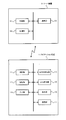
- FIG. 4 is a diagram for explaining a specific example of the color arrangement pattern information stored in the storage unit 32 of the server device 3.
- FIG. 4A shows an example of classification areas A to F in which a predetermined area is classified based on landscape information.
- FIG. 4B shows an example of color arrangement pattern information stored in the storage unit 32.
- the area type and the color arrangement pattern to be set are associated with each of the classification areas A to F.
- these color arrangement patterns are data including a set of set values related to an image displayed by the head-up display 2 as described above.
- the color arrangement pattern information includes the ranges of the classification areas A to F (the range of position coordinates, etc.) in addition to the information shown in FIG. 4B. Further, the area type may not be included in the color arrangement pattern information. That is, the color arrangement patterns may be directly associated with the classification areas A to F.
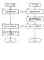
- the processing flow is repeatedly executed by the navigation device 1 and the server device 3.
- the communication unit 17 transmits information on the current position of the vehicle (current position information) to the server device 3 (step S11).
- the current position is obtained by the control unit 11 based on the value acquired from the GPS receiver 15 and / or the value acquired from the autonomous positioning device 14.
- the communication unit 33 receives the current position information from the communication unit 17 of the navigation device 1 (step S21). And the control part 31 refers to the information memorize
- the communication unit 17 receives the color arrangement pattern information from the communication unit 33 of the server device 3 (step S12). Then, the control unit 11 controls the head-up display 2 based on the color arrangement pattern information acquired in Step S12 (Step S13). Specifically, the control unit 11 controls the light source unit 4 of the head-up display 2 so that an image is displayed with a color scheme according to the color scheme pattern information.
- an image is displayed on the head-up display 2 using an optimum color arrangement pattern for each classification area obtained by classifying a predetermined area based on landscape information. For this reason, with respect to the scenery that constantly changes as the vehicle travels, it is possible to fix the color scheme until the vehicle runs through the traveling region after ensuring the optimal color scheme in consideration of certain information such as area classification. Therefore, according to the present embodiment, it is possible to ensure good visibility while suppressing flickering of the color of the display image.
- Modification 1 In FIG. 4, a predetermined area is classified according to a predetermined area type (mountain, residential area, beach, etc.), and a predetermined color scheme (mountain color pattern, residential area color pattern, seaside) used for each area type. An example of applying a color arrangement pattern) was shown. In Modified Example 1, instead of applying a predetermined color scheme used for each area type, an optimal color scheme (that is, for each classification area) for each area where a predetermined area is classified based on landscape information. A unique color scheme can be applied. In this case, it is not necessary to classify the predetermined area by area type.
- the color arrangement pattern information about the color arrangement pattern for each classification area obtained in advance is stored in the server device 3.
- the navigation device 1 mounted on each vehicle independently generates a color arrangement pattern
- the server device 3 accumulates the color arrangement pattern generated by the navigation device 1 of each vehicle in this manner, thereby classifying
- the color arrangement pattern information about the color arrangement pattern for each area can be stored in the server device 3.
- the navigation device 1 generates a color arrangement pattern according to the area in which the vehicle has traveled based on a camera image or map information captured by the front camera.
- the navigation device 1 generates a color arrangement pattern for each region where the scenery is similar based on the result of analyzing the color distribution of the camera image using a histogram or the like.
- the navigation device 1 transmits the travel history to the server device 3 together with the color arrangement pattern thus generated.
- the server device 3 stores the color arrangement pattern information about the color arrangement pattern for each area by accumulating the color arrangement patterns received from the navigation devices 1 mounted on a plurality of vehicles.
- the CPU 22 in the navigation device 1 corresponds to an example of the “generating unit” in the present invention.
- the embodiment and the modification 2 are the same in that the color arrangement pattern information stored in the server device 3 is transmitted to the navigation device 1. Moreover, the head-up display 2 may perform the process of generating the color arrangement pattern as described above instead of the navigation device 1.
- the color scheme of the image is changed according to the classification area.
- the color scheme of the image can be changed according to the season. This is because the color of the scenery (background) tends to change according to the season.
- the server device 3 stores a color arrangement pattern for each classification area corresponding to the season (that is, the color arrangement pattern is stored in association with the classification area and the season), and the current position And the color arrangement pattern which should be set according to the present date is extracted and transmitted to the navigation apparatus 1.
- Modification 4 In the above-described embodiment, the color scheme of the image displayed on the head-up display 2 is changed.
- the brightness of the image (in other words, the luminance. The same shall apply hereinafter) can be changed in addition to the color arrangement of the image or instead of the color arrangement of the image.
- the brightness of the image can be changed according to the weather and / or time. This is because the brightness of the scenery and the brightness in the vehicle tend to change according to the weather and time.
- the server device 3 uses color scheme pattern information including information on the brightness of an image to be set according to the weather and / or time (the color scheme pattern for changing the color scheme described above). May be included) to the navigation device 1.
- the server device 3 acquires the current weather and / or the current time from a predetermined site on the Internet, for example, and obtains the brightness of the image to be set based on the weather and / or the time. be able to.
- the “display control unit” according to the present invention is provided in the navigation device 1 (that is, the control unit 11 of the navigation device 1 functions as the “display control unit” according to the present invention).
- the “display control means” according to the present invention may be provided in the head-up display 2.
- the control unit 11 of the navigation device 1 performs control to change the color scheme of the head-up display 2 based on the color scheme pattern information received from the server device 3.
- the navigation device 1 supplies the color arrangement pattern information received from the server device 3 to the head-up display 2 as it is, and the head-up display 2 performs control for changing the color arrangement based on the color arrangement pattern information acquired from the navigation device 1.
- a control unit that controls the light source unit 4 of the head-up display 2 performs the control. That is, the control unit in the head-up display 2 functions as the “display control unit” according to the present invention.
- the present invention is not limited to application to the configuration composed of the navigation device 1 and the head-up display 2, but can also be applied to a configuration composed only of the head-up display 2. That is, the head-up display 2 can be applied as the “display device” according to the present invention. In that case, a communication unit capable of communicating with the server device 3 is provided in the head-up display 2 and, as described above, the control unit in the head-up display 2 may function as the “display control unit” according to the present invention.
- the present invention is not limited to application to the navigation device 1 and the head-up display 2, and can be similarly applied to a head-mounted display.
- the present invention can also be applied to a display device that displays an image superimposed on an image (camera image) obtained by photographing a forward landscape.
- a navigation device including a mobile terminal such as a smartphone
- a mobile terminal such as a smartphone
Landscapes
- Engineering & Computer Science (AREA)
- Radar, Positioning & Navigation (AREA)
- Remote Sensing (AREA)
- Automation & Control Theory (AREA)
- Physics & Mathematics (AREA)
- General Physics & Mathematics (AREA)
- Navigation (AREA)
Abstract
移動体の搭乗者に視認させる画像を表示する表示システムは、移動体と共に移動し、当該移動体の前方風景と重なるように画像を表示する表示手段と、所定の地域を当該地域における景観情報を基に分類したエリアに対応付けて配色パターン情報を記憶する記憶手段と、当該記憶手段から、移動体の現在位置に対応するエリアの配色パターン情報を取得する取得手段と、当該取得手段により取得された配色パターン情報を基に、表示手段で表示させる画像の配色及び/又は明るさを変化させる表示制御手段と、を備える。
Description
本発明は、情報を表示する技術分野に関する。
近年、ヘッドアップディスプレイなどを用いて、車両の進行方向の実風景に重ね合わせてナビゲーション情報などの画像を表示させる技術が提案されている。例えば、特許文献1には、フロントガラスに投影される表示像を外界の景色に重ね合わせて表示するヘッドアップディスプレイにおいて、外界の景色を撮像することで得られた撮像情報のうち表示像の背景に対応する部分の色に対してコントラストの高い色を、表示像の表示色として設定することが提案されている。
特許文献1に記載された技術では、撮影手段で逐次撮影をして表示色を補正するため、ヘッドアップディスプレイの表示像の色が走行中に頻繁に変化する傾向にあった。そのため、表示像の色がちらつくことで運転の集中を妨げてしまう可能性があった。
本発明が解決しようとする課題としては、上記のものが一例として挙げられる。本発明は、移動体の前方風景と重なるように画像を表示する構成において、表示像の色のちらつきを抑えつつ、最適な配色や明るさで画像を表示させることが可能な表示システムなどを提供することを主な目的とする。
請求項に記載の発明では、移動体の搭乗者に視認させる画像を表示する表示システムは、前記移動体と共に移動し、当該移動体の前方風景と重なるように前記画像を表示する表示手段と、所定の地域を当該地域における景観情報を基に分類したエリアに対応付けて配色パターン情報を記憶する記憶手段と、前記記憶手段から、前記移動体の現在位置に対応するエリアの配色パターン情報を取得する取得手段と、前記取得手段により取得された配色パターン情報を基に、前記表示手段で表示させる前記画像の配色及び/又は明るさを変化させる表示制御手段と、を備えることを特徴とする。
また、請求項に記載の発明では、サーバ装置は、所定の地域を当該地域における景観情報を基に分類したエリアに対応付けて配色パターン情報を記憶する記憶手段と、移動体と共に移動し当該移動体の前方風景と重なるように画像を表示する表示装置から、前記移動体の現在位置に関する情報を受信する受信手段と、前記記憶手段から、前記受信手段により受信された前記現在位置に対応するエリアの配色パターン情報を抽出し、当該配色パターン情報を前記表示装置に送信する送信手段と、を備えることを特徴とする。
また、請求項に記載の発明では、移動体と共に移動し、当該移動体の前方風景と重なるように画像を表示する表示手段を有する表示装置は、前記移動体の現在位置に関する情報を、所定の地域を当該地域における景観情報を基に分類したエリアに対応付けて配色パターン情報を記憶するサーバ装置に送信する送信手段と、前記サーバ装置から、前記現在位置に対応するエリアの配色パターン情報を受信する受信手段と、前記受信手段により受信された配色パターン情報を基に、前記表示手段で表示させる前記画像の配色及び/又は明るさを変化させる表示制御手段と、を備えることを特徴とする。
また、請求項に記載の発明では、移動体と共に移動し、当該移動体の前方風景と重なるように画像を表示する表示手段を有する表示装置は、前記移動体が走行した地域における景観情報を基に当該地域に応じた配色パターン情報を生成する生成手段と、前記生成手段により生成された配色パターン情報を、所定の地域内のエリアごとに配色パターン情報を記憶するサーバ装置に送信する送信手段と、を備えることを特徴とする。
また、請求項に記載の発明では、移動体と共に移動し、当該移動体の前方風景と重なるように画像を表示する表示手段を有する表示装置によって実行される表示方法は、前記移動体の現在位置に関する情報を、所定の地域を当該地域における景観情報を基に分類したエリアに対応付けて配色パターン情報を記憶するサーバ装置に送信する送信工程と、前記サーバ装置から、前記現在位置に対応するエリアの配色パターン情報を受信する受信工程と、前記受信工程により受信された配色パターン情報を基に、前記表示手段で表示させる前記画像の配色及び/又は明るさを変化させる表示制御工程と、を備えることを特徴とする。
また、請求項に記載の発明では、移動体と共に移動し、当該移動体の前方風景と重なるように画像を表示する表示手段及びコンピュータを有する表示装置によって実行されるプログラムは、前記コンピュータを、前記移動体の現在位置に関する情報を、所定の地域を当該地域における景観情報を基に分類したエリアに対応付けて配色パターン情報を記憶するサーバ装置に送信する送信手段、前記サーバ装置から、前記現在位置に対応するエリアの配色パターン情報を受信する受信手段、前記受信手段により受信された配色パターン情報を基に、前記表示手段で表示させる前記画像の配色及び/又は明るさを変化させる表示制御手段、として機能させることを特徴とする。
本発明の1つの観点では、移動体の搭乗者に視認させる画像を表示する表示システムは、前記移動体と共に移動し、当該移動体の前方風景と重なるように前記画像を表示する表示手段と、所定の地域を当該地域における景観情報を基に分類したエリアに対応付けて配色パターン情報を記憶する記憶手段と、前記記憶手段から、前記移動体の現在位置に対応するエリアの配色パターン情報を取得する取得手段と、前記取得手段により取得された配色パターン情報を基に、前記表示手段で表示させる前記画像の配色及び/又は明るさを変化させる表示制御手段と、を備える。
上記の表示システムでは、景観情報に基づいて所定の地域を分類したエリアごとの配色パターン情報に基づいて、画像の配色及び/又は明るさを変化させる。これにより、走行するに伴い絶えず変化する景色に対して、エリア区分という一定の情報を考慮し最適な配色を担保したうえで、走行中の地域を走り抜けるまでは配色を固定にすることができる。したがって、上記の表示システムによれば、表示像の色のちらつきを抑えつつ、良好な視認性を確保することが可能となる。
本発明の他の観点では、サーバ装置は、所定の地域を当該地域における景観情報を基に分類したエリアに対応付けて配色パターン情報を記憶する記憶手段と、移動体と共に移動し当該移動体の前方風景と重なるように画像を表示する表示装置から、前記移動体の現在位置に関する情報を受信する受信手段と、前記記憶手段から、前記受信手段により受信された前記現在位置に対応するエリアの配色パターン情報を抽出し、当該配色パターン情報を前記表示装置に送信する送信手段と、を備える。
また、本発明の他の観点では、移動体と共に移動し、当該移動体の前方風景と重なるように画像を表示する表示手段を有する表示装置は、前記移動体の現在位置に関する情報を、所定の地域を当該地域における景観情報を基に分類したエリアに対応付けて配色パターン情報を記憶するサーバ装置に送信する送信手段と、前記サーバ装置から、前記現在位置に対応するエリアの配色パターン情報を受信する受信手段と、前記受信手段により受信された配色パターン情報を基に、前記表示手段で表示させる前記画像の配色及び/又は明るさを変化させる表示制御手段と、を備える。
また、本発明の他の観点では、移動体と共に移動し、当該移動体の前方風景と重なるように画像を表示する表示手段を有する表示装置は、前記移動体が走行した地域における景観情報を基に当該地域に応じた配色パターン情報を生成する生成手段と、前記生成手段により生成された配色パターン情報を、所定の地域内のエリアごとに配色パターン情報を記憶するサーバ装置に送信する送信手段と、を備える。
また、本発明の他の観点では、移動体と共に移動し、当該移動体の前方風景と重なるように画像を表示する表示手段を有する表示装置によって実行される表示方法は、前記移動体の現在位置に関する情報を、所定の地域を当該地域における景観情報を基に分類したエリアに対応付けて配色パターン情報を記憶するサーバ装置に送信する送信工程と、前記サーバ装置から、前記現在位置に対応するエリアの配色パターン情報を受信する受信工程と、前記受信工程により受信された配色パターン情報を基に、前記表示手段で表示させる前記画像の配色及び/又は明るさを変化させる表示制御工程と、を備える。
また、本発明の他の観点では、移動体と共に移動し、当該移動体の前方風景と重なるように画像を表示する表示手段及びコンピュータを有する表示装置によって実行されるプログラムは、前記コンピュータを、前記移動体の現在位置に関する情報を、所定の地域を当該地域における景観情報を基に分類したエリアに対応付けて配色パターン情報を記憶するサーバ装置に送信する送信手段、前記サーバ装置から、前記現在位置に対応するエリアの配色パターン情報を受信する受信手段、前記受信手段により受信された配色パターン情報を基に、前記表示手段で表示させる前記画像の配色及び/又は明るさを変化させる表示制御手段、として機能させる。
上記のプログラムは、記録媒体に記録した状態で好適に取り扱うことができる。
以下、図面を参照して本発明の好適な実施例について説明する。
[システム構成]
図1は、本実施例に係る表示システム100の概略構成を示すブロックである。図1に示すように、表示システム100は、ナビゲーション装置1と、ヘッドアップディスプレイ2と、サーバ装置3と、を備える。ナビゲーション装置1及びヘッドアップディスプレイ2は、車両に搭載される。
図1は、本実施例に係る表示システム100の概略構成を示すブロックである。図1に示すように、表示システム100は、ナビゲーション装置1と、ヘッドアップディスプレイ2と、サーバ装置3と、を備える。ナビゲーション装置1及びヘッドアップディスプレイ2は、車両に搭載される。
ナビゲーション装置1は、主に、出発地から目的地までの経路案内を行う機能などを有する。また、ナビゲーション装置1は、ヘッドアップディスプレイ2にて表示させるべき画像を生成し、当該画像の情報をヘッドアップディスプレイ2に供給する。例えば、ナビゲーション装置1としては、一般的な据え置き型のナビゲーション装置や、PND(Portable Navigation Device)や、スマートフォンなどの携帯電話を適用することができる。
ヘッドアップディスプレイ2は、ナビゲーション装置1が生成した画像の情報を取得し、当該画像を運転者の目の位置(アイポイント)から虚像として視認させる。基本的には、ヘッドアップディスプレイ2は、車両の前方風景と重なるように画像を表示するように機能する。なお、ヘッドアップディスプレイ2は、本発明における「表示手段」の一例に相当する。また、ナビゲーション装置1及びヘッドアップディスプレイ2は、本発明における「表示装置」の一例に相当する。
サーバ装置3は、無線ネットワークなどにより、ナビゲーション装置1と通信可能に構成されている。ナビゲーション装置1とサーバ装置3との間では、種々の情報の授受がなされる。
なお、図1では、1つのナビゲーション装置1のみが示されているが、実際には、サーバ装置3は、複数のナビゲーション装置1との間で情報の授受を行う。
[ナビゲーション装置及びサーバ装置の構成]
図2は、ナビゲーション装置1及びサーバ装置3の概略構成を示すブロックである。
図2は、ナビゲーション装置1及びサーバ装置3の概略構成を示すブロックである。
ナビゲーション装置1は、主に、制御部11と、記憶部12と、入力部13と、自立測位装置14と、GPS受信機15と、表示部16と、通信部17と、を備える。
入力部13は、各種コマンドやデータを入力するための、キー、スイッチ、ボタン、リモコン、音声入力装置等から構成されている。表示部16がタッチパネル方式に構成されている場合には、表示部16の表示画面上に設けられたタッチパネルも入力部13として機能する。
自立測位装置14は、図示しない加速度センサや角速度センサや距離センサなどを備える。加速度センサは、例えば圧電素子からなり、車両の加速度を検出し、加速度データを出力する。角速度センサは、例えば振動ジャイロからなり、車両の方向変換時における車両の角速度を検出し、角速度データ及び相対方位データを出力する。距離センサは、車両の車輪の回転に伴って発生されているパルス信号からなる車速パルスを計測する。
GPS受信機15は、複数のGPS衛星から、測位用データを含む下り回線データを搬送する電波を受信する。測位用データは、緯度及び経度情報等から車両の絶対的な位置(現在位置)を検出するために用いられる。なお、各種の制御や処理で用いる現在位置としては、GPS受信機15から取得された値を用いることに限定はされず、GPS受信機15から取得された値及び/又は自立測位装置14から取得された値に基づいて求めた値を用いても良い。
表示部16は、例えば液晶ディスプレイなどにより構成され、ユーザに対して文字、画像などを表示する。表示部16を、タッチパネルなどにて構成しても良い。
通信部17は、サーバ装置3と無線通信を行うことが可能に構成されている。なお、通信部17は、本発明における「送信手段」及び「受信手段」の一例に相当する。
記憶部12は、例えばHDDなどにより構成され、地図データなどのナビゲーション処理に用いられる各種データを記憶する。
制御部11は、図示しないCPU(Central Processing Unit)やROM(Read Only Memory)やRAM(Random Access Memory)などを有しており、ナビゲーション装置1全体の制御を行う。例えば、制御部11は、出発地から目的地までのルート案内を行うための処理を行う。制御部11が行う処理については、詳細は後述する。なお、制御部11は、本発明における「表示制御手段」の一例に相当する。
他方で、サーバ装置3は、主に、制御部31と、記憶部32と、通信部33と、を備える。
通信部33は、ナビゲーション装置1と無線通信を行うことが可能に構成されている。例えば、通信部33は、複数のナビゲーション装置1と無線通信を行うことが可能に構成されている。なお、通信部33は、本発明における「送信手段」及び「受信手段」の一例に相当する。
記憶部32は、例えばHDDなどにより構成され、各種の情報を記憶している。例えば、記憶部32は、ヘッドアップディスプレイ2に適用すべき画像の配色パターンなどの情報を記憶している。なお、記憶部32は、本発明における「記憶手段」の一例である。
制御部31は、図示しないCPUやROMやRAMなどを有しており、サーバ装置3全体の制御を行う。制御部31が行う処理については、詳細は後述する。
[ヘッドアップディスプレイの構成]
図3は、ヘッドアップディスプレイ2の概略構成図である。図3に示すように、ヘッドアップディスプレイ2は、光源ユニット4と、コンバイナ9とを備え、フロントウィンドウ25、天井部27、ボンネット28、及びダッシュボード29などを備える車両に取り付けられる。
図3は、ヘッドアップディスプレイ2の概略構成図である。図3に示すように、ヘッドアップディスプレイ2は、光源ユニット4と、コンバイナ9とを備え、フロントウィンドウ25、天井部27、ボンネット28、及びダッシュボード29などを備える車両に取り付けられる。
光源ユニット4は、支持部材5a、5bを介して車室内の天井部27に設置され、表示すべき画像を構成する光を、コンバイナ9に向けて出射する。具体的には、光源ユニッ4は、上記したナビゲーション装置1によって生成された画像を取得し、その画像を構成する光をコンバイナ9へ出射することで、コンバイナ9を介して運転者に虚像Ivを視認させる。例えば、光源ユニット4は、レーザ光源やLCD光源などの光源を有しており、光源から光を出射する。
コンバイナ9は、ハーフミラーとして構成されている。コンバイナ9は、光源ユニット4から出射される表示像が投影されると共に、表示像を運転者のアイポイントPeへ反射することで当該表示像を虚像Ivとして視認させる。そして、コンバイナ9は、天井部27に設置された支持軸部8を有し、支持軸部8を支軸として回動する。支持軸部8は、例えば、フロントウィンドウ25の上端近傍の天井部27、言い換えると運転者用の図示しないサンバイザが設置される位置の近傍に設置される。なお、支持軸部8は、上述のサンバイザに代えて設置されても良い。
ヘッドアップディスプレイ2は、基本的には、コンバイナ9を透して観察される車両の前方風景と重なるように画像(表示像を意味する。以下同様とする。)を表示させる。
なお、図3に示したように、コンバイナ9を用いて画像を表示させることに限定はされず、コンバイナ9の代わりにフロントガラスを用いて画像を表示させても良い。また、光源ユニット4を天井部27に設置することに限定はされず、天井部27の代わりにダッシュボード29の内部に光源ユニット4を設置しても良い。
[表示制御方法]
次に、本実施例に係る表示制御方法について説明する。本実施例では、所定の地域を当該地域における景観情報を基に分類し(以下では、分類されたエリアを「分類エリア」と呼ぶ。)、分類エリアごとに、ヘッドアップディスプレイ2にて表示させる画像の配色パターンを設定する(この場合、分類エリアごとに最適な配色パターンを設定する)。そして、本実施例では、車両の現在位置に対応する分類エリアの配色パターンを用いて、ヘッドアップディスプレイ2にて画像を表示させる。
次に、本実施例に係る表示制御方法について説明する。本実施例では、所定の地域を当該地域における景観情報を基に分類し(以下では、分類されたエリアを「分類エリア」と呼ぶ。)、分類エリアごとに、ヘッドアップディスプレイ2にて表示させる画像の配色パターンを設定する(この場合、分類エリアごとに最適な配色パターンを設定する)。そして、本実施例では、車両の現在位置に対応する分類エリアの配色パターンを用いて、ヘッドアップディスプレイ2にて画像を表示させる。
このような制御を行う理由は以下の通りである。前述したように、ヘッドアップディスプレイ2は、車両の前方風景と重なるように画像を表示する。一般的には、ヘッドアップディスプレイ2にて表示させる画像の配色は、デザインなどで決められた固定された配色が用いられる。しかしながら、そのような固定された配色は、走行中の景色に対して最適ではない場合がある。例えば、ヘッドアップディスプレイ2にて表示させるルート情報の配色を緑色に固定した場合、都市や海辺の走行中にはルート情報は比較的見やすいが、山岳地帯の走行中にはルート情報が見えづらくなる場合がある。これは、都市や海辺の走行中における景色の色はルート情報の緑色と異なる傾向にあるが、山岳地帯の走行中における景色の色(森林の色など)はルート情報の緑色と近い傾向にあるからである。以上のことから、本実施例では、走行中の環境に応じた最適な配色パターンを用いて、ヘッドアップディスプレイ2により画像を表示させることとする。
具体的には、本実施例においては、ナビゲーション装置1では、通信部17が車両の現在位置に関する情報をサーバ装置3に送信し、サーバ装置3では、通信部33がナビゲーション装置1から現在位置に関する情報を受信すると、その現在位置に応じた配色パターンに関する情報(以下では「配色パターン情報」と呼ぶ。)を通信部33がナビゲーション装置1に送信する。この場合、サーバ装置3の記憶部32には、所定の地域を当該地域における景観情報を基に分類した分類エリアに対応付けて配色パターン情報が記憶されており、サーバ装置3の制御部31は、このような記憶部32に記憶された情報を参照することで、ナビゲーション装置1から受信した現在位置に対応する分類エリアの配色パターン情報を抽出し、当該配色パターン情報を通信部33によってナビゲーション装置1に送信する。そして、ナビゲーション装置1では、通信部17が配色パターン情報を受信すると、制御部11が当該配色パターン情報に基づいてヘッドアップディスプレイ2の配色などを変化させる制御を行う。
ここで、上記した分類エリアごとに設定される配色パターンについて説明する。まず、分類エリアは、ネットワーク上で取得される航空写真やストリート写真や、プローブカーで撮影された風景画像や、地図情報などに基づいて(これらの車両や画像などは、本発明における「景観情報」の一例に相当する)、ある程度の範囲を有する所定の地域を分類したエリアである。1つの例では、分類エリアとしては、海辺や、山岳や、工業地帯や、都市や、住宅地や、商業地などが用いられる。そのような分類エリアごとに配色パターンが設定される。例えば、配色パターンとしては、ヒストグラム等を用いて各分類エリアにおける色の分布を解析した結果に基づいて、各分類エリアにおける背景(景観)とヘッドアップディスプレイ2による画像とが少なくとも同系色にならないような最適な配色が適用される。こうして得られる分類エリアごとの配色パターンは、サーバ装置3の記憶部32に記憶される。より具体的には、記憶部32には、分類エリアの範囲(緯度経度で表される位置座標の範囲など)と、分類エリアの種別(例えば海辺や山岳や工業地帯などであり、以下では「エリア種別」と呼ぶ。)と、設定すべき配色パターンとが対応付けられた配色パターン情報が記憶される。
なお、上記した「配色パターン」は、文字や、看板の枠や、ルート情報の色や、ルート情報の明るさや、地図の表現や、POI(Point Of Interest)の表現などの、ヘッドアップディスプレイ2により表示させる画像に関する設定値一式に相当する。
図4は、サーバ装置3の記憶部32に記憶される配色パターン情報の具体例を説明するための図を示す。
図4(a)は、景観情報に基づいて所定の地域を分類した分類エリアA~Fの一例を示している。図4(b)は、記憶部32に記憶された配色パターン情報の一例を示している。図4(b)に示すように、配色パターン情報では、分類エリアA~Fごとに、エリア種別と、設定すべき配色パターンとが対応付けられている。この例では、配色パターンとして、エリア種別に応じた、山岳配色パターン、住宅地配色パターン、海辺配色パターン、都市配色パターン、及び工業地帯配色パターンが用いられている。実際には、これらの配色パターンは、前述したような、ヘッドアップディスプレイ2により表示させる画像に関する設定値一式を含むデータである。
なお、配色パターン情報には、図4(b)に示したもの以外にも、分類エリアA~Fの範囲(位置座標の範囲など)が含められる。また、配色パターン情報にエリア種別を含めなくても良い。つまり、分類エリアA~Fに対して配色パターンを直接対応付けても良い。
次に、図5を参照して、本実施例に係る処理フローについて説明する。当該処理フローは、ナビゲーション装置1及びサーバ装置3によって繰り返し実行される。
まず、ナビゲーション装置1では、通信部17が、車両の現在位置に関する情報(現在位置情報)をサーバ装置3に送信する(ステップS11)。この現在位置は、制御部11によって、GPS受信機15から取得された値及び/又は自立測位装置14から取得された値に基づいて求められる。
次に、サーバ装置3では、通信部33が、ナビゲーション装置1の通信部17から現在位置情報を受信する(ステップS21)。そして、制御部31が、記憶部32に記憶された情報を参照することで、ステップS21で取得された現在位置情報の現在位置に対応する分類エリア(つまり現在位置が含まれる分類エリア)の配色パターン情報を抽出する(ステップS22)。この後、通信部33が、ステップS22で抽出された配色パターン情報をナビゲーション装置1に送信する(ステップS23)。
次に、ナビゲーション装置1では、通信部17が、サーバ装置3の通信部33から配色パターン情報を受信する(ステップS12)。そして、制御部11が、ステップS12で取得した配色パターン情報に基づいて、ヘッドアップディスプレイ2を制御する(ステップS13)。具体的には、制御部11は、配色パターン情報に応じた配色にて画像が表示されるように、ヘッドアップディスプレイ2の光源ユニット4を制御する。
以上説明した本実施例によれば、景観情報に基づいて所定の地域を分類した分類エリアごとの最適な配色パターンを用いて、ヘッドアップディスプレイ2にて画像を表示させる。そのため、走行するに伴い絶えず変化する景色に対して、エリア区分という一定の情報を考慮し最適な配色を担保したうえで、走行中の地域を走り抜けるまでは配色を固定にすることができる。したがって、本実施例によれば、表示像の色のちらつきを抑えつつ、良好な視認性を確保することが可能となる。
[変形例]
以下では、上記した実施例に好適な変形例について説明する。なお、下記の変形例は、任意に組み合わせて上述の実施例に適用することができる。
以下では、上記した実施例に好適な変形例について説明する。なお、下記の変形例は、任意に組み合わせて上述の実施例に適用することができる。
(変形例1)
図4では、所定のエリアを予め定めたエリア種別(山岳や住宅地や海辺など)にて分類し、各エリア種別に対して用いる予め定めた配色パターン(山岳配色パターン、住宅地配色パターン、海辺配色パターン)を適用する例を示した。変形例1では、そのような各エリア種別に対して用いる予め定めた配色パターンを適用する代わりに、景観情報に基づいて所定の地域を分類したエリアごとに最適な配色パターン(つまり分類エリアごとに特有な配色パターン)を適用することができる。この場合には、所定のエリアをエリア種別にて分類する必要はない。
図4では、所定のエリアを予め定めたエリア種別(山岳や住宅地や海辺など)にて分類し、各エリア種別に対して用いる予め定めた配色パターン(山岳配色パターン、住宅地配色パターン、海辺配色パターン)を適用する例を示した。変形例1では、そのような各エリア種別に対して用いる予め定めた配色パターンを適用する代わりに、景観情報に基づいて所定の地域を分類したエリアごとに最適な配色パターン(つまり分類エリアごとに特有な配色パターン)を適用することができる。この場合には、所定のエリアをエリア種別にて分類する必要はない。
(変形例2)
上記した実施例では、予め求められた分類エリアごとの配色パターンについての配色パターン情報をサーバ装置3に記憶させていた。変形例2では、各車両に搭載されたナビゲーション装置1が独自に配色パターンを生成し、そのように各車両のナビゲーション装置1で生成された配色パターンをサーバ装置3にて蓄積することで、分類エリアごとの配色パターンについての配色パターン情報をサーバ装置3に記憶させることができる。この場合、ナビゲーション装置1は、前方カメラによって撮影されたカメラ画像や地図情報などに基づいて、車両が走行した地域に応じた配色パターンを生成する。例えば、ナビゲーション装置1は、カメラ画像に対してヒストグラム等を用いて色分布を解析した結果に基づいて、景観が似ている地域ごとに配色パターンを生成する。ナビゲーション装置1は、このように生成した配色パターンと共に、走行履歴をサーバ装置3に送信する。サーバ装置3は、複数の車両に搭載されたナビゲーション装置1から受信された配色パターン等を蓄積することで、エリアごとの配色パターンについての配色パターン情報を記憶する。なお、変形例2では、ナビゲーション装置1内のCPU22は、本発明における「生成手段」の一例に相当する。
上記した実施例では、予め求められた分類エリアごとの配色パターンについての配色パターン情報をサーバ装置3に記憶させていた。変形例2では、各車両に搭載されたナビゲーション装置1が独自に配色パターンを生成し、そのように各車両のナビゲーション装置1で生成された配色パターンをサーバ装置3にて蓄積することで、分類エリアごとの配色パターンについての配色パターン情報をサーバ装置3に記憶させることができる。この場合、ナビゲーション装置1は、前方カメラによって撮影されたカメラ画像や地図情報などに基づいて、車両が走行した地域に応じた配色パターンを生成する。例えば、ナビゲーション装置1は、カメラ画像に対してヒストグラム等を用いて色分布を解析した結果に基づいて、景観が似ている地域ごとに配色パターンを生成する。ナビゲーション装置1は、このように生成した配色パターンと共に、走行履歴をサーバ装置3に送信する。サーバ装置3は、複数の車両に搭載されたナビゲーション装置1から受信された配色パターン等を蓄積することで、エリアごとの配色パターンについての配色パターン情報を記憶する。なお、変形例2では、ナビゲーション装置1内のCPU22は、本発明における「生成手段」の一例に相当する。
なお、サーバ装置3に記憶された配色パターン情報をナビゲーション装置1に送信する点に関しては、実施例と変形例2とは同様である。また、上記したような配色パターンを生成する処理は、ナビゲーション装置1の代わりにヘッドアップディスプレイ2が行っても良い。
(変形例3)
上記した実施例では、分類エリアに応じて画像の配色を変化させていた。変形例3では、季節に応じて画像の配色を変化させることができる。こうするのは、季節に応じて景色(背景)の色が変わる傾向にあるからである。具体的には、変形例3では、季節に応じた分類エリアごとの配色パターンをサーバ装置3に記憶させておき(つまり分類エリア及び季節に対応付けて配色パターンを記憶させておく)、現在位置及び現在の日付に応じて設定すべき配色パターンを抽出してナビゲーション装置1に送信する。
上記した実施例では、分類エリアに応じて画像の配色を変化させていた。変形例3では、季節に応じて画像の配色を変化させることができる。こうするのは、季節に応じて景色(背景)の色が変わる傾向にあるからである。具体的には、変形例3では、季節に応じた分類エリアごとの配色パターンをサーバ装置3に記憶させておき(つまり分類エリア及び季節に対応付けて配色パターンを記憶させておく)、現在位置及び現在の日付に応じて設定すべき配色パターンを抽出してナビゲーション装置1に送信する。
(変形例4)
上記した実施例では、ヘッドアップディスプレイ2にて表示させる画像の配色を変化させていた。変形例3では、画像の配色に加えて、若しくは画像の配色の代わりに、画像の明るさ(言い換えると輝度である。以下同様とする。)を変化させることができる。具体的には、変形例4では、天候及び/又は時刻に応じて、画像の明るさを変化させることができる。こうするのは、天候や時刻に応じて、景色の明るさや車内の明るさが変わる傾向にあるからである。より具体的には、変形例4では、サーバ装置3は、天候及び/又は時刻に応じて設定すべき画像の明るさの情報を含む配色パターン情報(上記した配色を変化させるための配色パターンを含めても良い)を、ナビゲーション装置1に送信する。この場合、サーバ装置3は、例えばインターネット上の所定のサイトなどから現在の天候及び/又は現在の時刻を取得し、当該天候及び/又は当該時刻に基づいて、設定すべき画像の明るさを求めることができる。
上記した実施例では、ヘッドアップディスプレイ2にて表示させる画像の配色を変化させていた。変形例3では、画像の配色に加えて、若しくは画像の配色の代わりに、画像の明るさ(言い換えると輝度である。以下同様とする。)を変化させることができる。具体的には、変形例4では、天候及び/又は時刻に応じて、画像の明るさを変化させることができる。こうするのは、天候や時刻に応じて、景色の明るさや車内の明るさが変わる傾向にあるからである。より具体的には、変形例4では、サーバ装置3は、天候及び/又は時刻に応じて設定すべき画像の明るさの情報を含む配色パターン情報(上記した配色を変化させるための配色パターンを含めても良い)を、ナビゲーション装置1に送信する。この場合、サーバ装置3は、例えばインターネット上の所定のサイトなどから現在の天候及び/又は現在の時刻を取得し、当該天候及び/又は当該時刻に基づいて、設定すべき画像の明るさを求めることができる。
(変形例5)
上記した実施例では、本発明に係る「表示制御手段」をナビゲーション装置1に設けていたが(つまりナビゲーション装置1の制御部11が本発明に係る「表示制御手段」として機能していたが)、この代わりに、本発明に係る「表示制御手段」をヘッドアップディスプレイ2に設けても良い。具体的には、上記した実施例では、ナビゲーション装置1の制御部11が、サーバ装置3から受信した配色パターン情報に基づいてヘッドアップディスプレイ2の配色を変化させる制御を行っていたが、他の例では、ナビゲーション装置1は、サーバ装置3から受信した配色パターン情報をそのままヘッドアップディスプレイ2に供給し、ヘッドアップディスプレイ2は、ナビゲーション装置1から取得した配色パターン情報に基づいて配色を変化させる制御を行う。この他の例では、ヘッドアップディスプレイ2の光源ユニット4を制御する制御部が当該制御を行うこととなる。つまり、ヘッドアップディスプレイ2内の制御部が、本発明に係る「表示制御手段」として機能することとなる。
上記した実施例では、本発明に係る「表示制御手段」をナビゲーション装置1に設けていたが(つまりナビゲーション装置1の制御部11が本発明に係る「表示制御手段」として機能していたが)、この代わりに、本発明に係る「表示制御手段」をヘッドアップディスプレイ2に設けても良い。具体的には、上記した実施例では、ナビゲーション装置1の制御部11が、サーバ装置3から受信した配色パターン情報に基づいてヘッドアップディスプレイ2の配色を変化させる制御を行っていたが、他の例では、ナビゲーション装置1は、サーバ装置3から受信した配色パターン情報をそのままヘッドアップディスプレイ2に供給し、ヘッドアップディスプレイ2は、ナビゲーション装置1から取得した配色パターン情報に基づいて配色を変化させる制御を行う。この他の例では、ヘッドアップディスプレイ2の光源ユニット4を制御する制御部が当該制御を行うこととなる。つまり、ヘッドアップディスプレイ2内の制御部が、本発明に係る「表示制御手段」として機能することとなる。
更に、本発明は、ナビゲーション装置1及びヘッドアップディスプレイ2から成る構成への適用に限定はされず、ヘッドアップディスプレイ2のみから成る構成にも適用することができる。つまり、本発明に係る「表示装置」として、ヘッドアップディスプレイ2を適用することができる。その場合、サーバ装置3と通信可能な通信部をヘッドアップディスプレイ2に設けると共に、上記したようにヘッドアップディスプレイ2内の制御部を本発明に係る「表示制御手段」として機能させれば良い。
(変形例6)
本発明は、ナビゲーション装置1やヘッドアップディスプレイ2への適用に限定はされず、ヘッドマウントディスプレイにも同様に適用することができる。
本発明は、ナビゲーション装置1やヘッドアップディスプレイ2への適用に限定はされず、ヘッドマウントディスプレイにも同様に適用することができる。
また、本発明は、前方風景を撮影した画像(カメラ画像)に重ねて画像を表示させるような表示装置にも適用することができる。例えば、本発明は、車両の進行方向の実風景をカメラによって撮影し、撮影により得られたカメラ画像に画像を重ね合わせて自装置のディスプレイに表示させるナビゲーション装置(スマートフォンなどの携帯端末も含む)に適用することができる。
1 ナビゲーション装置
2 ヘッドアップディスプレイ
3 サーバ装置
11 制御部
17 通信部
31 制御部
32 記憶部
33 通信部
2 ヘッドアップディスプレイ
3 サーバ装置
11 制御部
17 通信部
31 制御部
32 記憶部
33 通信部
Claims (7)
- 移動体の搭乗者に視認させる画像を表示する表示システムであって、
前記移動体と共に移動し、当該移動体の前方風景と重なるように前記画像を表示する表示手段と、
所定の地域を当該地域における景観情報を基に分類したエリアに対応付けて配色パターン情報を記憶する記憶手段と、
前記記憶手段から、前記移動体の現在位置に対応するエリアの配色パターン情報を取得する取得手段と、
前記取得手段により取得された配色パターン情報を基に、前記表示手段で表示させる前記画像の配色及び/又は明るさを変化させる表示制御手段と、
を備えることを特徴とする表示システム。 - 所定の地域を当該地域における景観情報を基に分類したエリアに対応付けて配色パターン情報を記憶する記憶手段と、
移動体と共に移動し当該移動体の前方風景と重なるように画像を表示する表示装置から、前記移動体の現在位置に関する情報を受信する受信手段と、
前記記憶手段から、前記受信手段により受信された前記現在位置に対応するエリアの配色パターン情報を抽出し、当該配色パターン情報を前記表示装置に送信する送信手段と、
を備えることを特徴とするサーバ装置。 - 移動体と共に移動し、当該移動体の前方風景と重なるように画像を表示する表示手段を有する表示装置であって、
前記移動体の現在位置に関する情報を、所定の地域を当該地域における景観情報を基に分類したエリアに対応付けて配色パターン情報を記憶するサーバ装置に送信する送信手段と、
前記サーバ装置から、前記現在位置に対応するエリアの配色パターン情報を受信する受信手段と、
前記受信手段により受信された配色パターン情報を基に、前記表示手段で表示させる前記画像の配色及び/又は明るさを変化させる表示制御手段と、
を備えることを特徴とする表示装置。 - 移動体と共に移動し、当該移動体の前方風景と重なるように画像を表示する表示手段を有する表示装置であって、
前記移動体が走行した地域における景観情報を基に当該地域に応じた配色パターン情報を生成する生成手段と、
前記生成手段により生成された配色パターン情報を、所定の地域内のエリアごとに配色パターン情報を記憶するサーバ装置に送信する送信手段と、
を備えることを特徴とする表示装置。 - 移動体と共に移動し、当該移動体の前方風景と重なるように画像を表示する表示手段を有する表示装置によって実行される表示方法であって、
前記移動体の現在位置に関する情報を、所定の地域を当該地域における景観情報を基に分類したエリアに対応付けて配色パターン情報を記憶するサーバ装置に送信する送信工程と、
前記サーバ装置から、前記現在位置に対応するエリアの配色パターン情報を受信する受信工程と、
前記受信工程により受信された配色パターン情報を基に、前記表示手段で表示させる前記画像の配色及び/又は明るさを変化させる表示制御工程と、
を備えることを特徴とする表示方法。 - 移動体と共に移動し、当該移動体の前方風景と重なるように画像を表示する表示手段及びコンピュータを有する表示装置によって実行されるプログラムであって、
前記コンピュータを、
前記移動体の現在位置に関する情報を、所定の地域を当該地域における景観情報を基に分類したエリアに対応付けて配色パターン情報を記憶するサーバ装置に送信する送信手段、
前記サーバ装置から、前記現在位置に対応するエリアの配色パターン情報を受信する受信手段、
前記受信手段により受信された配色パターン情報を基に、前記表示手段で表示させる前記画像の配色及び/又は明るさを変化させる表示制御手段、
として機能させることを特徴とするプログラム。 - 請求項6に記載のプログラムを記録したことを特徴とする記録媒体。
Priority Applications (1)
| Application Number | Priority Date | Filing Date | Title |
|---|---|---|---|
| PCT/JP2012/082830 WO2014097406A1 (ja) | 2012-12-18 | 2012-12-18 | 表示システム、サーバ装置、表示装置、表示方法及びプログラム |
Applications Claiming Priority (1)
| Application Number | Priority Date | Filing Date | Title |
|---|---|---|---|
| PCT/JP2012/082830 WO2014097406A1 (ja) | 2012-12-18 | 2012-12-18 | 表示システム、サーバ装置、表示装置、表示方法及びプログラム |
Publications (1)
| Publication Number | Publication Date |
|---|---|
| WO2014097406A1 true WO2014097406A1 (ja) | 2014-06-26 |
Family
ID=50977791
Family Applications (1)
| Application Number | Title | Priority Date | Filing Date |
|---|---|---|---|
| PCT/JP2012/082830 Ceased WO2014097406A1 (ja) | 2012-12-18 | 2012-12-18 | 表示システム、サーバ装置、表示装置、表示方法及びプログラム |
Country Status (1)
| Country | Link |
|---|---|
| WO (1) | WO2014097406A1 (ja) |
Cited By (1)
| Publication number | Priority date | Publication date | Assignee | Title |
|---|---|---|---|---|
| JP2016170308A (ja) * | 2015-03-13 | 2016-09-23 | 株式会社ゼンリンデータコム | 情報処理装置、地図表示システム、プログラム |
Citations (3)
| Publication number | Priority date | Publication date | Assignee | Title |
|---|---|---|---|---|
| JPH1131295A (ja) * | 1997-07-14 | 1999-02-02 | Toshiba Corp | 道路情報管理システムおよび道路情報端末装置 |
| JP2003058992A (ja) * | 2001-08-10 | 2003-02-28 | Matsushita Electric Ind Co Ltd | 地図データの配信が可能なセンタ、端末及びシステム |
| JP2011214868A (ja) * | 2010-03-31 | 2011-10-27 | Aisin Aw Co Ltd | 表示制御装置、方法およびプログラム |
-
2012
- 2012-12-18 WO PCT/JP2012/082830 patent/WO2014097406A1/ja not_active Ceased
Patent Citations (3)
| Publication number | Priority date | Publication date | Assignee | Title |
|---|---|---|---|---|
| JPH1131295A (ja) * | 1997-07-14 | 1999-02-02 | Toshiba Corp | 道路情報管理システムおよび道路情報端末装置 |
| JP2003058992A (ja) * | 2001-08-10 | 2003-02-28 | Matsushita Electric Ind Co Ltd | 地図データの配信が可能なセンタ、端末及びシステム |
| JP2011214868A (ja) * | 2010-03-31 | 2011-10-27 | Aisin Aw Co Ltd | 表示制御装置、方法およびプログラム |
Cited By (1)
| Publication number | Priority date | Publication date | Assignee | Title |
|---|---|---|---|---|
| JP2016170308A (ja) * | 2015-03-13 | 2016-09-23 | 株式会社ゼンリンデータコム | 情報処理装置、地図表示システム、プログラム |
Similar Documents
| Publication | Publication Date | Title |
|---|---|---|
| US20200219325A1 (en) | Information providing method and information providing vehicle therefor | |
| US20150175068A1 (en) | Systems and methods for augmented reality in a head-up display | |
| WO2020060308A1 (ko) | 전자 장치 및 전자 장치의 차량 제어 방법, 서버 및 서버의 정밀 지도 데이터 제공 방법 | |
| US20140098008A1 (en) | Method and apparatus for vehicle enabled visual augmentation | |
| JP7236442B2 (ja) | 自動車における表示デバイスの制御方法 | |
| EP3694740A1 (en) | Display device, program, image processing method, display system, and moving body | |
| JP5735658B2 (ja) | 表示装置及び表示方法 | |
| JP2015172548A (ja) | 表示制御装置、制御方法、プログラム、及び記憶媒体 | |
| WO2013088511A1 (ja) | 表示装置、表示方法、ヘッドアップディスプレイ及び検出装置 | |
| CN103366708A (zh) | 具有实景导游功能的透明显示器 | |
| JP2015128956A (ja) | ヘッドアップディスプレイ、制御方法、プログラム、及び記憶媒体 | |
| JP5795386B2 (ja) | 表示装置及び制御方法 | |
| JP2015141155A (ja) | 虚像表示装置、制御方法、プログラム、及び記憶媒体 | |
| WO2015114807A1 (ja) | 虚像表示装置、制御方法、プログラム、及び記憶媒体 | |
| JP2015105903A (ja) | ナビゲーション装置、ヘッドアップディスプレイ、制御方法、プログラム、及び記憶媒体 | |
| JP2023120221A (ja) | ヘッドアップディスプレイ、制御方法、プログラム、及び記憶媒体 | |
| JP2015127170A (ja) | ヘッドアップディスプレイ、制御方法、プログラム、及び記憶媒体 | |
| JP2019120652A (ja) | 車両用表示装置 | |
| WO2013069141A1 (ja) | ヘッドアップディスプレイ、表示方法、及び案内装置 | |
| WO2014097406A1 (ja) | 表示システム、サーバ装置、表示装置、表示方法及びプログラム | |
| WO2014049705A1 (ja) | 表示制御装置、表示制御方法及びプログラム、並びにサーバ装置 | |
| WO2013088512A1 (ja) | 表示装置及び表示方法 | |
| WO2014002167A1 (ja) | 情報表示装置、情報表示方法、情報表示プログラム及び記録媒体 | |
| WO2013046425A1 (ja) | ヘッドアップディスプレイ、制御方法、及び表示装置 | |
| WO2013046423A1 (ja) | ヘッドアップディスプレイ、制御方法、及び表示装置 |
Legal Events
| Date | Code | Title | Description |
|---|---|---|---|
| 121 | Ep: the epo has been informed by wipo that ep was designated in this application |
Ref document number: 12890438 Country of ref document: EP Kind code of ref document: A1 |
|
| NENP | Non-entry into the national phase |
Ref country code: DE |
|
| 122 | Ep: pct application non-entry in european phase |
Ref document number: 12890438 Country of ref document: EP Kind code of ref document: A1 |
|
| NENP | Non-entry into the national phase |
Ref country code: JP |