JP7288317B2 - Correction information transmission system - Google Patents
Correction information transmission system Download PDFInfo
- Publication number
- JP7288317B2 JP7288317B2 JP2019044315A JP2019044315A JP7288317B2 JP 7288317 B2 JP7288317 B2 JP 7288317B2 JP 2019044315 A JP2019044315 A JP 2019044315A JP 2019044315 A JP2019044315 A JP 2019044315A JP 7288317 B2 JP7288317 B2 JP 7288317B2
- Authority
- JP
- Japan
- Prior art keywords
- satellite
- mobile station
- correction information
- satellites
- transmission system
- Prior art date
- Legal status (The legal status is an assumption and is not a legal conclusion. Google has not performed a legal analysis and makes no representation as to the accuracy of the status listed.)
- Active
Links
- 238000012937 correction Methods 0.000 title claims description 171
- 230000005540 biological transmission Effects 0.000 title claims description 79
- 238000004891 communication Methods 0.000 claims description 108
- 238000004364 calculation method Methods 0.000 claims description 45
- 238000012545 processing Methods 0.000 description 47
- 238000010586 diagram Methods 0.000 description 13
- 238000000034 method Methods 0.000 description 13
- 230000008569 process Effects 0.000 description 9
- 230000006870 function Effects 0.000 description 7
- 230000006866 deterioration Effects 0.000 description 5
- 238000010276 construction Methods 0.000 description 4
- 239000004065 semiconductor Substances 0.000 description 4
- 230000008901 benefit Effects 0.000 description 2
- 238000006243 chemical reaction Methods 0.000 description 2
- 230000000694 effects Effects 0.000 description 2
- 238000005516 engineering process Methods 0.000 description 2
- 230000007274 generation of a signal involved in cell-cell signaling Effects 0.000 description 2
- 230000008054 signal transmission Effects 0.000 description 2
- 230000006872 improvement Effects 0.000 description 1
- 238000009434 installation Methods 0.000 description 1
- 238000005259 measurement Methods 0.000 description 1
- 238000012986 modification Methods 0.000 description 1
- 230000004048 modification Effects 0.000 description 1
- 230000003287 optical effect Effects 0.000 description 1
- 238000004088 simulation Methods 0.000 description 1
Images


Classifications
-
- G—PHYSICS
- G01—MEASURING; TESTING
- G01S—RADIO DIRECTION-FINDING; RADIO NAVIGATION; DETERMINING DISTANCE OR VELOCITY BY USE OF RADIO WAVES; LOCATING OR PRESENCE-DETECTING BY USE OF THE REFLECTION OR RERADIATION OF RADIO WAVES; ANALOGOUS ARRANGEMENTS USING OTHER WAVES
- G01S19/00—Satellite radio beacon positioning systems; Determining position, velocity or attitude using signals transmitted by such systems
- G01S19/01—Satellite radio beacon positioning systems transmitting time-stamped messages, e.g. GPS [Global Positioning System], GLONASS [Global Orbiting Navigation Satellite System] or GALILEO
- G01S19/03—Cooperating elements; Interaction or communication between different cooperating elements or between cooperating elements and receivers
- G01S19/07—Cooperating elements; Interaction or communication between different cooperating elements or between cooperating elements and receivers providing data for correcting measured positioning data, e.g. DGPS [differential GPS] or ionosphere corrections
-
- G—PHYSICS
- G01—MEASURING; TESTING
- G01S—RADIO DIRECTION-FINDING; RADIO NAVIGATION; DETERMINING DISTANCE OR VELOCITY BY USE OF RADIO WAVES; LOCATING OR PRESENCE-DETECTING BY USE OF THE REFLECTION OR RERADIATION OF RADIO WAVES; ANALOGOUS ARRANGEMENTS USING OTHER WAVES
- G01S19/00—Satellite radio beacon positioning systems; Determining position, velocity or attitude using signals transmitted by such systems
- G01S19/01—Satellite radio beacon positioning systems transmitting time-stamped messages, e.g. GPS [Global Positioning System], GLONASS [Global Orbiting Navigation Satellite System] or GALILEO
- G01S19/13—Receivers
- G01S19/22—Multipath-related issues
-
- G—PHYSICS
- G01—MEASURING; TESTING
- G01S—RADIO DIRECTION-FINDING; RADIO NAVIGATION; DETERMINING DISTANCE OR VELOCITY BY USE OF RADIO WAVES; LOCATING OR PRESENCE-DETECTING BY USE OF THE REFLECTION OR RERADIATION OF RADIO WAVES; ANALOGOUS ARRANGEMENTS USING OTHER WAVES
- G01S19/00—Satellite radio beacon positioning systems; Determining position, velocity or attitude using signals transmitted by such systems
- G01S19/01—Satellite radio beacon positioning systems transmitting time-stamped messages, e.g. GPS [Global Positioning System], GLONASS [Global Orbiting Navigation Satellite System] or GALILEO
- G01S19/13—Receivers
- G01S19/24—Acquisition or tracking or demodulation of signals transmitted by the system
- G01S19/28—Satellite selection
-
- G—PHYSICS
- G01—MEASURING; TESTING
- G01S—RADIO DIRECTION-FINDING; RADIO NAVIGATION; DETERMINING DISTANCE OR VELOCITY BY USE OF RADIO WAVES; LOCATING OR PRESENCE-DETECTING BY USE OF THE REFLECTION OR RERADIATION OF RADIO WAVES; ANALOGOUS ARRANGEMENTS USING OTHER WAVES
- G01S19/00—Satellite radio beacon positioning systems; Determining position, velocity or attitude using signals transmitted by such systems
- G01S19/38—Determining a navigation solution using signals transmitted by a satellite radio beacon positioning system
- G01S19/39—Determining a navigation solution using signals transmitted by a satellite radio beacon positioning system the satellite radio beacon positioning system transmitting time-stamped messages, e.g. GPS [Global Positioning System], GLONASS [Global Orbiting Navigation Satellite System] or GALILEO
- G01S19/42—Determining position
- G01S19/43—Determining position using carrier phase measurements, e.g. kinematic positioning; using long or short baseline interferometry
Landscapes
- Engineering & Computer Science (AREA)
- Radar, Positioning & Navigation (AREA)
- Remote Sensing (AREA)
- Computer Networks & Wireless Communication (AREA)
- Physics & Mathematics (AREA)
- General Physics & Mathematics (AREA)
- Position Fixing By Use Of Radio Waves (AREA)
Description
本発明は,高精度衛星測位に必要な補正情報を移動局に送信する補正情報送信システムに関する。 The present invention relates to a correction information transmission system for transmitting correction information necessary for high-precision satellite positioning to mobile stations.
近年,無人航空機や自動車,建設機械など,屋外で使用される移動体の位置情報を取得するための技術として,RTK(Real Time Kinematic)測位と呼ばれる高精度衛星測位技術が使用されている。RTK測位では,移動体に設置された移動局が,人工衛星から送信され移動局の受信機で受信される衛星信号と,基準局で受信した衛星信号をもとに生成され基準局から送信される補正情報とに基づいて測位演算を行う。 In recent years, high-precision satellite positioning technology called RTK (Real Time Kinematic) positioning has been used as a technology for acquiring position information of mobile objects used outdoors, such as unmanned aerial vehicles, automobiles, and construction machinery. In RTK positioning, a mobile station installed in a mobile object is a satellite signal transmitted from an artificial satellite and received by the receiver of the mobile station, and a correction generated based on the satellite signal received at the reference station and transmitted from the reference station Positioning calculation is performed based on the information.
RTK測位では,移動局で受信する衛星信号を利用して測位演算の精度を向上させる技術が知られている。例えば,特許文献1では,移動局で受信した衛星信号について,衛星信号の信号強度マスク及び衛星の仰角による仰角マスクを複数用いることで測位演算の精度を向上させている。 In RTK positioning, a technique is known that uses satellite signals received by mobile stations to improve the accuracy of positioning calculations. For example, in Patent Document 1, for satellite signals received by a mobile station, the accuracy of positioning calculation is improved by using a plurality of signal strength masks of satellite signals and elevation angle masks based on elevation angles of satellites.
ところで,基準局から移動局に対して補正情報を送信するための通信インフラが充分整っていない場合や,基準局と移動局との間の通信速度が制限される環境では,移動局で最新の補正情報を使用した測位演算を行うことができず,測位精度が低下するおそれがある。特に建設機械の稼働する工事現場等では通信インフラが不充分であることが少なくなく,この種の課題が露呈しやすい。 By the way, when the communication infrastructure for transmitting correction information from the reference station to the mobile station is not sufficiently prepared, or in an environment where the communication speed between the reference station and the mobile station is limited, the latest correction information is not available at the mobile station. Positioning calculations cannot be performed using Especially at construction sites where construction machinery is in operation, communication infrastructure is often inadequate, and this kind of problem is likely to be exposed.
そこで本発明は,補正情報の通信速度が充分でない環境においても,移動局における測位精度の低下を抑制できる補正情報送信システムを提供することを目的とする。 SUMMARY OF THE INVENTION Accordingly, it is an object of the present invention to provide a correction information transmission system capable of suppressing deterioration of positioning accuracy in a mobile station even in an environment where the communication speed of correction information is not sufficient.
本願は上記課題を解決する手段を複数含んでいるが,その一例を挙げるならば,移動局がRTK測位に使用する補正情報を生成する制御装置と,前記制御装置で生成された前記補正情報を前記移動局に送信する通信装置とを備えた補正情報送信システムにおいて,前記制御装置は,基準点から送信される複数の衛星からの衛星信号を前記通信装置を介して取得し,前記制御装置に記憶された前記移動局の周辺の障害物の位置及び形状の情報と,前記移動局から送信される前記移動局の位置情報と,前記複数の衛星からの衛星信号に含まれる前記複数の衛星の位置情報とに基づいて,前記複数の衛星からの衛星信号のうちマルチパスの影響を受けずに前記移動局が受信できる衛星信号を送信する衛星を,前記移動局が測位演算に衛星信号を使用する衛星として推定し,前記通信装置の通信速度から規定されるデータ量に前記補正情報のデータ量が収まるように,前記複数の衛星の中から前記推定した衛星を優先的に選択することで前記補正情報を生成する。
The present application includes a plurality of means for solving the above problems, but to give an example, a control device that generates correction information used by the mobile station for RTK positioning, and the correction information generated by the control device and a communication device for transmitting to the mobile station, the control device acquires satellite signals from a plurality of satellites transmitted from a reference point via the communication device, and transmits the satellite signals to the control device. stored information on the position and shape of obstacles around the mobile station; position information on the mobile station transmitted from the mobile station ; Based on the positional information, the mobile station uses the satellite signals for positioning calculation to determine which of the satellite signals from the plurality of satellites transmits a satellite signal that can be received by the mobile station without being affected by multipath. by preferentially selecting the estimated satellite from among the plurality of satellites so that the data amount of the correction information falls within the data amount specified from the communication speed of the communication device. Generate correction information .
本発明によれば,基準局において移動局の測位演算に使用する衛星を推測し,通信速度に応じたデータ量になるよう優先度の高い衛星を選択し補正情報として送信する。これにより通信速度が充分でない環境においても,移動局は測位に使用する衛星に関する補正情報を受信することができ,測位精度の低下を抑制できる。 According to the present invention, the reference station estimates the satellites to be used for the positioning calculation of the mobile station, selects satellites with high priority so that the amount of data corresponds to the communication speed, and transmits the correction information. As a result, even in an environment where the communication speed is not sufficient, the mobile station can receive the correction information related to the satellites used for positioning, thereby suppressing deterioration of the positioning accuracy.
以下,本発明の実施の形態について図面を用いて説明する。 BEST MODE FOR CARRYING OUT THE INVENTION Embodiments of the present invention will be described below with reference to the drawings.
<第1実施形態>
図1は本発明の第1実施形態に係る衛星測位システムのハードウェア構成図である。この図に示す衛星測位システムは,補正情報を生成して送信する補正情報送信システム1と,補正情報送信システム1から送信される補正情報を利用して移動体の位置を計測する移動局2と,衛星信号を補正情報送信システム1に送信する衛星信号取得システム3とを備えている。
<First embodiment>
FIG. 1 is a hardware configuration diagram of a satellite positioning system according to the first embodiment of the present invention. The satellite positioning system shown in FIG. , and a satellite
移動局2は,複数の人工衛星(測位衛星)から送信される衛星信号を受信するGNSSアンテナ(衛星信号受信装置)201と,補正情報送信システム1から送信される補正情報と衛星信号取得システム3に送信する移動局位置情報とを含む各種情報を送受信する通信装置203と,GNSSアンテナ201で受信した複数の衛星信号と補正情報送信システム1から受信した補正情報とに基づいて移動局(移動体)の位置情報(移動局位置情報)を演算するコントローラ(受信機)202とを備えている。これらの機器201,202,203は建設機械などの移動体に搭載されている。
The
コントローラ202は,移動体に搭載可能なコンピュータやマイクロコントローラなどの小型の制御装置(受信機)である。
The
通信装置203は,携帯電話通信網等の回線を使用して有線または無線でインターネットに接続する装置や,BLUETOOTH(登録商標)やWIFI(登録商標)業務用無線などの無線通信装置により通信を行う装置,その他有線接続による通信を行う通信装置のうち1つまたは複数の装置を含む装置である。
The
衛星信号取得システム3は,移動局2の近くに位置する地理座標系における位置座標が既知の点で受信される衛星信号を補正情報送信システム1に出力するためのシステムである。衛星信号取得システム3としては,地理座標系における位置座標が既知の基準点に設置された固定局や,電子基準点やVRS(Virtual Reference Station)方式等の補正情報配信サービスが利用可能である。本実施形態では,VRS方式の補正情報配信サービスを衛星信号取得システム3として使用した場合について記述する。
The satellite
本実施形態の衛星信号取得システム3は,複数の電子基準点36と衛星信号を受信可能に接続されたVRSサーバ31と,VRSサーバ31に各種情報を送受信する通信装置37とを備えている。
The satellite
各電子基準点36は,地理座標系における位置座標が既知のGNSS連続観測点であり,衛星信号を受信するためのGNSSアンテナ(図示せず)と,GNSSアンテナで受信された衛星信号を基に位置計測する受信機(図示せず)と,電子基準点36での観測データ(受信した衛星信号や測位結果等)を送信するための通信機(図示せず)とを備えている。なお,紙面の都合上,図1では2つの電子基準点36を,図2には3つの電子基準点36を示しているが,電子基準点36の数に限定はなく,移動局2の周辺に位置するできるだけ多くの電子基準点36とVRSサーバ31を接続することが好ましい。
Each
VRSサーバ31は,演算制御装置(例えば,中央処理装置(CPU)),記憶装置(例えば,ROM,RAM等の半導体メモリ),及び入出力装置を備えたサーバ(コンピュータ)である。VRSサーバ31は,移動局2の位置情報を基に移動局2の周辺に位置する電子基準点36を複数選択し,その選択した複数の電子基準点36が受信した衛星信号に基づいて,移動局2の近くに設置される仮想基準点(VRS点)からの衛星信号を生成して補正情報送信システム1に出力する。
The
補正情報送信システム1は,移動局2で衛星信号を受信可能な複数の衛星の中から移動局2との通信状況が良好な衛星を優先的に選択して補正情報の生成に利用することで移動局に送信可能なデータ量まで補正情報のデータ量を低減して移動局2に送信するためのシステムである。
The correction information transmission system 1 preferentially selects a satellite with good communication conditions with the
補正情報送信システム1は,制御装置101と,制御装置101に各種情報を送受信する通信装置102とを備えている。
The correction information transmission system 1 includes a
制御装置101は,コンピュータやマイクロコントローラなどの利用が可能であり,演算制御装置(例えば,中央処理装置(CPU)),記憶装置(例えば,ROM,RAM等の半導体メモリ),及び入出力装置を備えている(何れも図示せず)。制御装置101の記憶装置には,移動局2の周囲に位置し得る衛星信号を遮蔽する物体の位置及び形状の情報が格納されている。当該物体は例えば建物や地形であり,以下ではこの情報を「障害物情報」と称することがある。
The
通信装置102は,携帯電話通信網等の回線を使用して有線または無線でインターネットに接続する装置や,BLUETOOTH(登録商標)やWIFI(登録商標)業務用無線などの無線通信装置により通信を行う装置,その他有線接続による通信を行う通信装置のうち1つまたは複数の装置を含む装置である。
The
なお,補正情報送信システム1と移動局2の間には,1つ以上の中継局やデータ変換を行う装置等が存在していてもよい。
Between the correction information transmission system 1 and the
図2は図1中のVRSサーバ31,制御装置101,及びコントローラ(受信機)202の機能ブロック図である。
FIG. 2 is a functional block diagram of the
衛星信号取得システム3におけるVRSサーバ31は,記憶装置に記憶されたプログラムを演算制御装置で実行することで,位置情報受信部32と,衛星信号取得部33と,仮想基準点衛星信号演算部34と,仮想基準点衛星信号出力部35として機能する。
The
位置情報受信部32は,移動局2のコントローラ202が演算して通信装置203から送信した移動局位置情報を通信装置37を介して受信する処理を行う部分である。
The position
衛星信号取得部33は,位置情報受信部32で受信した移動局位置情報と各電子基準点36の位置情報とに基づいて,移動局2の周辺に存在する複数の電子基準点36を選択し,その選択した複数の電子基準点36で受信された衛星信号を通信装置37を介して取得する処理を行う部分である。
The satellite
仮想基準点衛星信号演算部34は,移動局2の付近に仮想基準点を作成し,この仮想基準点に固定局を設置した場合に移動局2が受信できる衛星信号を,衛星信号取得部33で選択した複数の電子基準点36からの衛星信号に基づいてシミュレーションにより演算(生成)する処理を行う部分である。
The virtual reference point
仮想基準点衛星信号出力部35は,仮想基準点衛星信号演算部34で演算(生成)された仮想基準点からの衛星信号を補正情報送信システム1に通信装置37を介して出力する処理を行う部分である。
The virtual reference point satellite
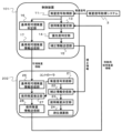
補正情報送信システム1における制御装置101は,記憶装置に記憶されたプログラムを演算制御装置で実行することで,衛星信号取得部11と,移動局位置受信部12と,使用衛星推定部13と,優先度判定部14と,補正情報送信部15として機能する。これにより制御装置101は,衛星信号取得システム3から出力される衛星信号と,移動局2から出力される移動局位置情報とを入力として,補正情報を移動局2に出力する。
The
衛星信号取得部11は,衛星信号取得システム3が作成した仮想基準点から送信される複数の衛星の衛星信号を,通信装置102を介して取得する処理を行う部分である。ここで取得される衛星信号のデータ量が通信装置102の単位時間当たりの通信速度に対して通信可能な範囲の量である場合,後続の処理は補正情報送信部15で行われ,衛星信号取得部11で取得された全ての衛星信号に基づいて生成された補正情報が送信される。一方,通信速度が充分でない場合は移動局位置受信部12で以下に説明する処理が行われる。
The satellite
移動局位置受信部12は,移動局2のコントローラ202が演算して通信装置203から送信した移動局位置情報を通信装置102を介して受信する処理を行う部分である。
The mobile station position receiving unit 12 is a part that receives the mobile station position information calculated by the
使用衛星推定部13は,衛星信号取得システム3が作成した仮想基準点から衛星信号が送信される複数の衛星の中から移動局2が測位演算に使用する衛星を,移動局位置受信部12で受信した移動局位置情報と,制御装置101の記憶装置に記憶した障害物情報とに基づいて推定する処理を行う部分である。本実施形態の使用衛星推定部13は,移動局2の周辺の障害物の情報と,移動局2の位置情報と,複数の衛星の位置情報とに基づいて,複数の衛星からの衛星信号のうちマルチパスの影響を受けずに移動局2が受信できる衛星信号を送信する衛星を,移動局2が測位演算に衛星信号を使用する衛星として推定する。
The satellite-in-
使用衛星推定部13が実行する処理について,図3に示す移動局2の周囲環境を表した説明図を用いて説明する。この図に示すように移動局2の周囲には複数の障害物及び衛星が存在する。図3の場合,衛星1から送信される信号は障害物1により遮蔽され,衛星2から送信される信号は障害物2によりマルチパスの影響を受け,衛星3からの信号はこれらの障害物の影響を受けない(すなわちマルチパスの影響を受けない)。そのため,衛星から送信される衛星信号のうち図3に示す衛星1や衛星2のように障害物による遮蔽やマルチパスなどの影響を受ける衛星の信号に比べ,衛星3のようにノイズの少ない衛星の信号を移動局2の測位演算に使用する方が精度が向上する。つまり,図3の場合,移動局2は,衛星1や衛星2に比較して,衛星3を測位演算に使用する可能性が高い。そこで,本実施形態の使用衛星推定部13は,制御装置101の記憶装置に記録された障害物情報及び移動局位置情報と,衛星信号取得部11で取得した衛星信号に含まれる各衛星の仰角及び方位角情報(すなわち衛星の位置情報)とに基づいて,移動局2の位置で受信できる各衛星からの衛星信号の信号品質を算出し,その衛星信号品質に基づいて移動局2が測位演算に使用する可能性が高い衛星を推定している。衛星信号の信号品質は,例えば,移動局2の周囲に位置する障害物(地形,建物等)による遮蔽の有無や,マルチパスの影響を考慮して推定されるS/N比(信号雑音比)の値から評価できる。
The processing executed by the used
優先度判定部14は,通信装置102の通信速度から規定されるデータ量に補正情報のデータ量が収まるように,衛星信号取得システム3から衛星信号が送信される複数の衛星の中から使用衛星推定部13が推定した衛星を優先的に選択する処理を行う部分である。優先度判定部14は,まず,2つの通信装置102,203による通信で単位時間当たりに送信可能な補正情報のデータ量を求める。次にそのデータ量の補正情報に含めることが可能な衛星数(以下において「送信可能衛星数」と称することがある)を求める。最後に,優先度判定部14は,衛星信号取得部11で衛星信号を取得した複数の衛星の中から,使用衛星推定部13で求めた衛星信号品質と,衛星配置(例えばDOP値)などの観点に基づいて,移動局2において精度よく測位できる衛星の組合せを送信可能衛星数の範囲内(好ましくは送信可能衛星数と同数)で決定する。なお,送信可能衛星数は,都度演算するのではなく,予め設定しておいても良い。
The
補正情報送信部15は,優先度判定部14によって選択された衛星の衛星信号に基づいて補正情報を生成し,その補正情報を移動局2に送信する処理を行う部分である。補正情報送信部15は,衛星信号取得部11で取得された複数の衛星信号のデータ量が通信装置102の単位時間当たりの通信速度に対して充分通信できる範囲である場合は取得したすべての衛星信号を基に生成した補正情報を,そうでない場合は優先度判定部14により決定された衛星の衛星信号を基にした補正情報を送信する。ただし,通信速度が充分な場合においても優先度判定部14で決定した衛星の衛星信号を基に生成した補正情報を送信してもよい。また,補正情報は各衛星に関する搬送波位相や疑似距離等の情報を含んでいてもよい。
The correction
移動局2におけるコントローラ202は,記憶装置に記憶されたプログラムを演算制御装置で実行することで,衛星信号受信部21と,補正情報受信部22と,使用衛星決定部23と,測位演算部24と,位置情報送信部25として機能する。これによりコントローラ202は,補正情報送信システム1から出力される補正情報を入力とし,移動局2において測位演算することにより得られる移動局位置情報を補正情報送信システム1及び衛星信号取得システム3に出力する。
A
衛星信号受信部21は,GNSSアンテナ201で受信された複数の衛星からの衛星信号を受信する。
The
補正情報受信部22は,補正情報送信システム1(制御装置101)から送信される補正情報を受信する。
The correction
使用衛星決定部23は,衛星信号受信部21で受信した衛星信号の信号品質と,補正情報受信部22で受信した補正情報に含まれる衛星の情報とに基づいて,移動局2の測位演算に使用する衛星の組合せを決定する。使用衛星決定部23が決定した衛星は,衛星信号受信部21で衛星信号を受信した衛星かつ補正情報受信部22で受信した補正情報に含まれる衛星の中で,移動局2の測位演算に使用される衛星となる。
The used
測位演算部24は,使用衛星決定部23で決定された衛星の組合せにおいて,衛星信号受信部21で受信した衛星信号と,補正情報受信部22で受信した補正情報とを使用して移動局2の測位演算を行う。
The
位置情報送信部25は,測位演算部24で算出された移動局2の位置情報を,補正情報送信システム1(制御装置101)及び衛星信号取得システム3(VRSサーバ31)に対して通信装置203を介して送信する。
The position
図4を用いて第1実施形態に係る衛星信号取得システム3のVRSサーバ31による衛星信号の生成・送信処理の流れについて説明する。本実施形態に係るVRSサーバ31は所定の周期で図4に示す処理フローを開始する。
The flow of satellite signal generation/transmission processing by the
まず,衛星信号取得システム3のVRSサーバ31(位置情報受信部32)は,移動局2の通信装置203から送信される移動局位置情報を通信装置37を介して受信する(S31)。なお,移動局2における移動局位置情報の取得は,RTK測位だけでなく単独測位で取得してもよい。
First, the VRS server 31 (location information receiving section 32) of the satellite
S32では,VRSサーバ31(衛星信号取得部33)は,観測データを入手可能な複数の電子基準点36の中から,S1で取得した移動局2の移動局位置情報に基づいて移動局2の周辺に存在する電子基準点36を複数選択する。なお,ここで選択する電子基準点36は1つでも構わない。
In S32, the VRS server 31 (satellite signal acquisition unit 33) selects the
S33では,VRSサーバ31(仮想基準点衛星信号演算部34)は,S32で選択した複数の電子基準点36の観測データを取得し,その取得した複数の電子基準点36の観測データに基づいて移動局2の付近に仮想基準点を作成する。
In S33, the VRS server 31 (virtual reference point satellite signal calculator 34) acquires the observation data of the plurality of
S34では,VRSサーバ31(仮想基準点衛星信号演算部34)は,S32で選択した複数の電子基準点36の観測データを用いて,S33で作成した仮想基準点から送信されるべき衛星信号を演算(生成)する。なお,仮想基準点の設置位置は,例えば移動局2のコントローラ202による測位結果である移動局位置と一致させても良い。
In S34, the VRS server 31 (virtual reference point satellite signal calculator 34) uses the observation data of the plurality of
S35では,VRSサーバ31(仮想基準点衛星信号出力部35)は,S34で演算した仮想基準局からの衛星信号を補正情報送信システム1の制御装置101(通信装置102)に対して通信装置37を介して送信し,最初の処理S31に戻る。
In S35, the VRS server 31 (virtual reference point satellite signal output unit 35) transmits the satellite signal from the virtual reference station calculated in S34 to the controller 101 (communication device 102) of the correction information transmission system 1 via the
図5を用いて第1実施形態に係る補正情報送信システム1の制御装置101による補正情報の生成・送信処理の流れについて説明する。本実施形態に係る制御装置101は所定の周期で図5に示す処理フローを開始する。
The flow of correction information generation/transmission processing by the
まずS13において,補正情報送信システム1の制御装置101(衛星信号取得部11)は,衛星信号取得システム3のVRSサーバ31から図4のS35で送信された仮想基準点での衛星信号を取得し,S14へ進む。
First, in S13, the control device 101 (satellite signal acquisition unit 11) of the correction information transmission system 1 acquires the satellite signal at the virtual reference point transmitted from the
S14では,制御装置101(衛星信号取得部11)は,S13で取得した衛星信号のデータ量と,通信装置102,203が単位時間あたりに通信できるデータ量を比較する。このとき通信装置102,203の通信速度が所定の時間内にS13で取得した全ての衛星信号を送信するために必要な通信速度を超えており充分速い場合には,S18に処理を進める。一方,通信装置102,203の通信速度が不充分である場合にはS15に進む。なお,通信速度が充分であるかどうかは,例えば単位時間あたりに通信可能なデータ量が,衛星信号のデータ量に安全率を乗じたしきい値を上回っているかどうかにより判定することができる。
In S14, the control device 101 (satellite signal acquisition unit 11) compares the amount of satellite signal data acquired in S13 with the amount of data that can be communicated by the
S18では,通信装置102,203の通信速度がS13で取得した衛星信号のデータ量に対して充分であるため,制御装置101(補正情報送信部15)は,S13で衛星信号を取得した全ての衛星に関する衛星信号を含む補正情報を移動局2に対して送信する。
In S18, since the communication speed of the
一方,S15では,制御装置101(使用衛星推定部13)は,制御装置101内の記憶装置に記録された障害物情報と,移動局2から送信された移動局位置情報と,S13で取得した衛星信号に含まれる各衛星の位置情報とに基づいて,地形や障害物による衛星信号の遮蔽やマルチパスの影響を考慮して各衛星からの衛星信号の品質を算出して,S16へ進む。
On the other hand, in S15, the control device 101 (satellite estimation unit 13) uses the obstacle information recorded in the storage device in the
S16では,制御装置101(優先度判定部14)は,2つの通信装置102,203間で送信可能なデータ量に基づいて定められる送信可能衛星数と,S15で演算した衛星信号品質と,S13で取得した衛星信号に含まれる各衛星の位置情報と,衛星配置(DOP値)などに基づいて,送信可能衛星数の衛星数の範囲内において,移動局2での測位に使用する可能性の高い衛星の組合せを決定する。
In S16, the control device 101 (priority determination unit 14) determines the number of transmittable satellites determined based on the amount of data that can be transmitted between the two
S16に係る,移動局2での測位に使用される可能性の高い衛星の組合せは,例えば次のような手順で決定してもよい。まず,S15で使用衛星推定部13を用いて求めた衛星信号品質を演算した複数の衛星のうち品質が或る一定のしきい値を超える衛星を選別する。そしてその選別した衛星の中から,送信可能衛星数と同数の衛星を選択するすべての組合せについて,衛星配置に起因する精度低下率であるDOP値を演算する。このときのDOP値をもとに,すべての組合せの中から最も精度低下率の指標であるDOP値が低い組合せを,補正情報に優先的に含めるべき衛星の組合せとして決定する。ただし,衛星信号品質のしきい値は,固定的な値とする必要はなく,送信可能衛星数に応じて変更してもよい。なお,補正情報送信システム1が同一回線,同一周波数,または同一チャンネルで複数の移動局2等に補正情報を送信する場合,例えばそれぞれの移動局2について最もDOP値が低い衛星の組合せを求め,それらの衛星の組合せに含まれる頻度が高い順に送信可能衛星数分の衛星を選択し,その選択した衛星を補正情報として送信すべき衛星の組合せとしてもよい。
The combination of satellites that are likely to be used for positioning by the
S17では,制御装置101(補正情報送信部)は,S13で衛星信号取得システム3から衛星信号を取得した衛星のうち,S16で組合せを決定した複数の衛星の衛星信号を補正情報として移動局2に通信装置102を介して送信する。このように送信された補正情報は,2つの通信装置102,203間の通信(補正情報送信システム1と移動局2の通信)で許容されるデータ量の範囲内で,移動局2の測位精度を最大化できる高品質の衛星信号に基づいて生成されている。そのため,移動局2は,この補正情報の基となった衛星信号と当該補正情報を利用して測位を行うことにより,通信速度に制限のある環境下においても移動局2の衛星測位精度の低下を抑制できる。
At S17, the control device 101 (correction information transmission unit) sends the satellite signals of the plurality of satellites whose combination was determined at S16 among the satellites whose satellite signals were acquired from the satellite
S19では,制御装置101(移動局位置取得部12)は,補正情報送信システム1(制御装置101)から取得した補正情報と,GNSSアンテナ201で受信した衛星信号とに基づいて移動局2がRTK測位を行うことで取得した移動局位置情報を移動局2から取得し,S13の処理に戻る。
In S19, the control device 101 (mobile station position acquisition unit 12) causes the
(効果)
以上のように構成された第1実施形態に係る衛星測位システムでは,補正情報送信システム1の制御装置101が,衛星信号取得システム3のVRSサーバ31から衛星信号が送信される複数の衛星のうち,移動局2のコントローラ202による測位に使用する可能性の高い衛星を推測し,その推測した衛星の衛星情報を優先的に選択することで通信装置102の通信速度から規定されるデータ量に納めた補正情報を移動局2に送信する。これにより移動局2での測位演算に使用される衛星の情報が含まれた補正情報が,通信装置102の通信速度で充分送信可能なデータ量で送信され,通信速度に制限のある環境下においても移動局2の衛星測位精度を維持することができる。
(effect)
In the satellite positioning system according to the first embodiment configured as described above, the
本実施形態では,補正情報送信システム1の制御装置101は,移動局2での測位に使用される可能性の高い衛星の推測に際し,移動体の位置情報,障害物の位置情報,衛星の位置情報に基づいて各衛星信号の品質を演算し,良好な品質な衛星信号を選別している。さらに,品質で選別した衛星の中から送信可能衛星数と同数の衛星数を選択する全ての組み合わせについてDOP値を演算し,その中でDOP値が最小となる組合せに含まれる衛星の衛星信号から補正情報を生成することとしている。そのため,補正情報を利用した移動局2の測位精度の一層の向上が見込める。
In this embodiment, the
<第2実施形態>
次に本発明の第2実施形態に係る衛星測位システムについて説明する。第1実施形態では,移動局2と衛星と障害物(地形,建物等)の位置に基づいて移動局2での通信状況の良い衛星を推定し,その衛星の信号から補正情報を生成することで補正情報のデータ量を制限した。これに対して,本実施形態では,基準局(衛星信号取得システム3)での通信状況の良い衛星の情報(可視衛星情報)と,移動局2での通信状況が良く移動局2で測位演算に使用される可能性のある衛星の情報(移動局使用衛星情報)とを対比して,それらに共通する衛星の信号から補正情報を生成することで補正情報のデータ量の削減を図っている。以下,本実施の形態の詳細について説明する。なお,第1実施形態と同じ部分には同じ符号を付して説明を省略することがある。
<Second embodiment>
Next, a satellite positioning system according to a second embodiment of the invention will be described. In the first embodiment, based on the positions of the
図6は本発明の第2実施形態に係る衛星測位システムのハードウェア構成図である。第1実施形態とは衛星信号取得システムの構成が変化しており,本実施形態の衛星信号取得システム3は,地理座標系における位置座標が既知の基準点に設置された固定局である。ただし,第1実施形態のように電子基準点やVRS方式等の補正情報配信サービスを利用することも可能である。衛星信号取得システム3は,固定局(図示せず)に実装されており,固定局で受信された衛星信号を補正情報送信システム1に対して出力する。
FIG. 6 is a hardware configuration diagram of a satellite positioning system according to the second embodiment of the present invention. The configuration of the satellite signal acquisition system is different from that of the first embodiment, and the satellite
図6の衛星信号取得システム3は,複数の衛星から衛星信号を受信するためのGNSSアンテナ301と,GNSSアンテナ301で受信された衛星信号を他の機器と通信可能なフォーマットに変換する制御装置302と,制御装置302に各種情報を送受信する通信装置303とを備えている。
The satellite
制御装置302は,コンピュータやマイクロコントローラなどの利用が可能であり,演算制御装置(例えば,中央処理装置(CPU)),記憶装置(例えば,ROM,RAM等の半導体メモリ),及び入出力装置を備えている(何れも図示せず)。
The
通信装置303は,携帯電話通信網等の回線を使用して有線または無線でインターネットに接続する装置や,BLUETOOTH(登録商標)やWIFI(登録商標)業務用無線などの無線通信装置により通信を行う装置,その他有線接続による通信を行う通信装置のうち1つまたは複数の装置を含む装置である。
The
詳細は後述するが,補正情報送信システム1は移動局2に対して補正情報と可視衛星情報を送信しており,移動局2は補正情報送信システム1に対して移動局使用衛星情報を送信している。
Although the details will be described later, the correction information transmission system 1 transmits correction information and visible satellite information to the
図7は図6中の制御装置101,及びコントローラ(受信機)202の機能ブロック図である。
FIG. 7 is a functional block diagram of the
補正情報送信システム1における制御装置101は,衛星信号取得部11と,使用衛星推定部13と,優先度判定部14と,補正情報送信部15と,基準局可視衛星判定部16と,基準局可視衛星情報送信部17として機能する。制御装置101は,衛星信号取得システム3から出力される衛星信号と,移動局2から出力される移動局使用衛星情報とを入力とし,補正情報を移動局2に出力する。なお,補正情報送信システム1(制御装置101)と移動局2(コントローラ202)の間には,1つ以上の中継局やデータ変換を行う装置等が存在していてもよい。
The
衛星信号取得部11は,基準点(固定局)である衛星信号取得システム3(制御装置302)から送信される複数の衛星の衛星信号を,通信装置102を介して取得する処理を行う部分である。既述の通り,この衛星信号は,GNSSアンテナ301を介して衛星信号取得システム3(制御装置302)が受信したものである
使用衛星推定部13は,衛星信号取得システム3から衛星信号が送信される複数の衛星の中から移動局2が測位演算(RTK測位)に使用する衛星を,移動局2から送信される移動局使用衛星情報に基づいて推定する処理を行う部分である。移動局使用衛星情報とは,移動局2での通信状況が良好な衛星の情報であって,移動局2で測位に使用する可能性が比較的高い衛星の情報のことである。
The satellite
優先度判定部14は,通信装置102の通信速度から規定されるデータ量に補正情報のデータ量が収まるように,衛星信号取得システム3から衛星信号が送信される複数の衛星の中から使用衛星推定部13が推定した衛星を優先的に選択する処理を行う部分である。優先度判定部14は,まず,2つの通信装置102,203による通信で単位時間当たりに送信可能な補正情報のデータ量を求める。次にそのデータ量の補正情報に含めることが可能な送信可能衛星数を求める。最後に,優先度判定部14は,使用衛星推定部13で取得した移動局使用衛星情報をもとに,移動局2において精度よく測位できる衛星の組合せを送信可能衛星数の範囲内(好ましくは送信可能衛星数と同数)で決定する。
The
なお,補正情報送信システム1が同一回線,同一周波数,または同一チャンネルで複数の移動局2等に補正情報を送信する場合,例えばそれぞれの移動局2から受信した移動局使用衛星情報に含まれる衛星のうち,各移動局2から送信される移動局使用衛星情報に含まれる頻度の高い順に送信可能衛星数と同数の衛星を選択し,その選択した衛星を補正情報として送信すべき衛星の組合せとしてもよい。また,各移動局2から送信される移動局使用衛星情報に含まれる,各移動局2における測位演算結果への影響度合いに関する情報と,各移動局2に対して任意に設定できる優先度合いとに基づいて,補正情報として送信すべき衛星を選択してもよい。
When the correction information transmission system 1 transmits correction information to a plurality of
補正情報送信部15は,優先度判定部14によって選択された衛星の衛星信号に基づいて補正情報を生成し,その補正情報を移動局2に送信する処理を行う部分である。補正情報には各衛星に関する搬送波位相や疑似距離等の情報を含むことができる。
The correction
基準局可視衛星判定部16は,衛星信号取得部11で衛星信号を取得した複数の衛星の中から,基準局(衛星信号取得システム3)において遮蔽やマルチパスの影響を受けずに衛星信号を受信することができた衛星(以下において「基準局可視衛星」と称することがある)を判定する処理を行う部分である。基準局可視衛星であるか否かの判定は,例えば,各衛星の衛星信号のSN比が,所定のしきい値以上であるか否かに基づいて行うことができる。すなわち,SN比が所定のしきい値以上の場合には基準局可視衛星と判定し,SN比が所定のしきい値未満の場合には基準局可視衛星に該当しないと判定する。
The reference station visible
基準局可視衛星情報送信部17は,基準局可視衛星判定部16で判定された基準局可視衛星の衛星番号を可視衛星情報として移動局2へ通信装置102を介して送信する処理を行う部分である。
The reference station visible satellite
移動局2におけるコントローラ202は,記憶装置に記憶されたプログラムを演算制御装置で実行することで,衛星信号受信部21と,補正情報受信部22と,使用衛星決定部23と,測位演算部24と,基準局可視衛星情報受信部26と,使用衛星推定部27と,使用衛星情報送信部28として機能する。これによりコントローラ202は,補正情報送信システム1から出力される補正情報及び基準局可視衛星情報を入力とし,移動局2において測位演算することにより得られる移動局位置情報及び移動局使用衛星情報を出力する。
A
衛星信号受信部21,補正情報受信部22,使用衛星決定部23,及び測位演算部24による処理内容は,第1実施形態と同じである。
The contents of processing by the satellite
基準局可視衛星情報受信部26は,補正情報送信システム1(制御装置101)から送信される基準局可視衛星情報を受信する処理を行う部分である。
The reference station visible satellite
使用衛星推定部27は,衛星信号受信部21から入力したGNSSアンテナ201で衛星信号が受信された複数の衛星と,補正情報送信システム1から送信された基準局可視衛星情報に含まれた複数の衛星とに基づいて,補正情報送信システム1が送信する補正情報に含まれるべき衛星を求める処理を行う部分である。補正情報に含まれるべき衛星は,GNSSアンテナ201で衛星信号が受信された複数の衛星からなる第1グループと,基準局可視衛星情報に含まれた複数の衛星からなる第2グループとを比較し,双方のグループに含まれる衛星(両グループで重複する衛星)から選択される。補正情報に含まれるべき衛星を算出する際,使用衛星推定部27は,衛星信号受信部21から入力した移動局2における衛星信号の信号品質や,基準局可視衛星情報に規定された衛星の配置及び軌道情報などに基づいて,移動局2での測位演算の精度が高くなるような衛星の組合せを演算し,例えば,測位精度が最も良くなる衛星の組合せを補正情報に含まれるべき衛星とすることができる。このとき,各衛星の組み合わせや各衛星を使用した際の測位演算結果に与える影響度合いに関して演算を行ってもよい。
The used
使用衛星情報送信部28は,使用衛星推定部27で演算された衛星の組合せ(すなわち,補正情報送信システム1が送信する補正情報に含まれるべき衛星の組合せ)や測位演算結果への影響度合いなどの情報を含んだ移動局使用衛星情報を補正情報送信システム1に送信する処理を行う部分である。なお,移動局使用衛星情報には移動局2が測位に利用していない衛星の情報も含まれ得る。このような衛星も含めることで,何らかの理由で補正情報に含まれる衛星数が少なかったり,補正情報が受け取れなかったりした場合でも,次に補正情報送信システム1が送信する補正情報に含まれるべき衛星の数が制限されることを防止できる。具体的には,移動局2の起動直後に測位に必要な衛星数が足りずにエラーが発生することが防止できる。
The used satellite
図8を用いて第2実施形態に係る補正情報送信システム1の処理の流れについて説明する。本実施形態に係る制御装置101は所定の周期で図8に示す処理フローを開始する。
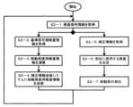
A processing flow of the correction information transmission system 1 according to the second embodiment will be described with reference to FIG. The
まず,補正情報送信システム1の制御装置101(衛星信号取得部11)は,衛星信号取得システム3から基準局で受信された複数の衛星の衛星信号を取得し(S1-1),S1-2及びS1-4の処理へ進む。 First, the control device 101 (satellite signal acquisition unit 11) of the correction information transmission system 1 acquires satellite signals of a plurality of satellites received by the reference station from the satellite signal acquisition system 3 (S1-1), S1-2 and Proceed to the processing of S1-4.
S1-2では,制御装置101(使用衛星推定部13)は,移動局2から送信される移動局使用衛星情報を取得する。
In S1-2, the control device 101 (satellite estimation unit 13) acquires mobile station satellite information transmitted from the
S1-3では,制御装置101(優先度判定部14)は,通信装置102の通信速度から演算した送信可能衛星数と,S1-2で取得した移動局使用衛星情報とに基づいて,移動局2において精度よく測位できる衛星の組合せを送信可能衛星数の範囲で決定し,S1-5の処理へ進む。
In S1-3, the control device 101 (priority determination unit 14) selects the mobile station based on the number of transmittable satellites calculated from the communication speed of the
一方,S1-4では,制御装置101(基準局可視衛星判定部16)は,S1-1で衛星信号を取得した複数の衛星の中から,基準局(衛星信号取得システム3)において遮蔽やマルチパスの影響を受けずに衛星信号を受信することができた衛星(基準局可視衛星)を判定してS1-5の処理へ進む。 On the other hand, in S1-4, the control device 101 (reference station visible satellite determination unit 16) selects a plurality of satellites from which satellite signals were acquired in S1-1, and determines whether the reference station (satellite signal acquisition system 3) is shielded or multipath. Satellites (reference station visible satellites) from which satellite signals could be received without being affected are determined, and the process proceeds to S1-5.
なお,図示では,S1-2からS1-3の処理とS1-4の処理とが並列処理により実行されるようになっているが,これらの処理は並列処理でなく順次行ってもよい。 In the drawing, the processing of S1-2 to S1-3 and the processing of S1-4 are executed by parallel processing, but these processing may be executed sequentially instead of parallel processing.
S1-5では,S1-3で決定した組合せに含まれる衛星の衛星信号を含んだ補正情報を生成して通信装置102を介して移動局1に送信するとともに,S1-4で判定した基準局可視衛星の情報を通信装置102を介して移動局2へ送信して,最初の処理(S1-1)に戻る。
In S1-5, correction information including the satellite signals of the satellites included in the combination determined in S1-3 is generated and transmitted to the mobile station 1 via the
次に,図9を用いて第2実施形態に係る移動局2における移動局使用衛星情報の演算処理の流れについて説明する。本実施形態に係る移動局2のコントローラ202は所定の周期で図9に示す処理フローを開始する。
Next, with reference to FIG. 9, the flow of calculation processing of satellite information used by the mobile station in the
まず,移動局2のコントローラ202(衛星信号受信部21)は,GNSSアンテナ201によって移動局2で受信される衛星信号を取得し,S2-2の処理に進む(S2-1)。
First, the controller 202 (satellite signal receiving unit 21) of the
S2-2では,コントローラ202(基準局可視衛星情報受信部26)は,補正情報送信システム1から送信される基準局可視衛星情報を取得しS2-3へ進む。 In S2-2, the controller 202 (reference station visible satellite information receiving unit 26) acquires the reference station visible satellite information transmitted from the correction information transmission system 1, and proceeds to S2-3.
S2-3では,コントローラ202(使用衛星推定部27)は,S2-1で取得した移動局2で受信した衛星信号と,S2-2で取得した基準局可視衛星情報とに基づいて,移動局の測位演算結果の精度が高くなるような衛星の組合せ及び測位演算結果への影響度合いなどの情報を含む移動局使用衛星情報を求める。
At S2-3, the controller 202 (satellite estimation unit 27) determines the mobile station based on the satellite signal received by the
S2-4では,コントローラ202(使用衛星情報送信部28)は,S-3で求めた移動局使用衛星情報を通信装置203を介して補正情報送信システム1(制御装置101)へ送信し,S2-1の処理へ進む。
In S2-4, the controller 202 (satellite information transmission unit 28) transmits the mobile station use satellite information obtained in S-3 to the correction information transmission system 1 (control device 101) via the
一方,S2-5では,コントローラ202(補正情報受信部22)は,補正情報送信システム1(制御装置101)から送信される補正情報を受信する。 On the other hand, in S2-5, the controller 202 (correction information receiving section 22) receives correction information transmitted from the correction information transmission system 1 (control device 101).
S2-6では,コントローラ202(使用衛星決定部23)は,S2-1で受信した衛星信号の信号品質と,S2-5で受信した補正情報に含まれる衛星の情報とに基づいて,移動局2の測位演算に使用する衛星の組合せを決定する。ここで決定される衛星は,S2-1で衛星信号を受信した衛星の番号と,S2-5で受信した補正情報に含まれる衛星の番号とを比較し,両者に重複した番号の衛星に含まれる。 At S2-6, the controller 202 (satellite determination unit 23) selects the mobile station based on the signal quality of the satellite signal received at S2-1 and the satellite information included in the correction information received at S2-5. 2 determines the combination of satellites to be used for the positioning calculation. The satellites determined here are determined by comparing the number of the satellite from which the satellite signal was received in S2-1 and the number of the satellite included in the correction information received in S2-5. be
S2-7では,コントローラ202(測位演算部24)は,S2-6で決定した組合せの衛星の衛星信号と,S2-5で受信した補正情報とに基づいて移動局2の測位演算を行って,S2-1の処理へ進む。
At S2-7, the controller 202 (positioning calculation unit 24) performs positioning calculation for the
なお,図示では,S2-2からS1-3の処理とS1-4の処理とが並列処理により実行されるようになっているが,これらの処理は並列処理でなく順次行ってもよい。 In the drawing, the processing of S2-2 to S1-3 and the processing of S1-4 are executed by parallel processing, but these processing may be executed sequentially instead of parallel processing.
以上の構成により本実施形態の補正情報送信システム1では,地形情報等の事前情報なしに,移動局2での測位演算に使用する衛星の情報が含まれた補正情報を,通信装置102の通信速度で充分送信可能なデータ量で送信することができ,通信速度に制限のある環境下においても移動局2の衛星測位精度を維持することができる。
With the above configuration, in the correction information transmission system 1 of this embodiment, the correction information including satellite information used for positioning calculations in the
(効果)
上記のように構成された第2実施形態に係る衛星測位システムでは,補正情報送信システム1の制御装置101(基準局可視衛星判定部16)が基準局(衛星信号取得システム3)で衛星信号の受信状況の良い衛星(基準局可視衛星)の番号を移動局2に送信する。移動局2のコントローラ202(使用衛星推定部27)は,例えば,その基準局可視衛星と,移動局2で衛星信号の受信状況の良い衛星との双方に含まれる衛星を選択し,その選択した衛星の情報を移動局使用衛星情報(すなわち,移動局2が測位演算に衛星信号を使用する可能性のある衛星の情報)として補正情報送信システム1に送信する。この移動局使用衛星情報を受信した補正情報送信システム1の制御装置101(優先度判定部14)は,通信機102で送信可能なデータ量の範囲内まで移動局使用衛星情報に含まれる衛星数を低減し,その衛星数低減後の衛星信号を基に生成した補正情報を移動局2(補正情報受信部22)に送信する。移動局2のコントローラ202(測位演算部24)は衛星数低減後の補正情報とその補正情報に含まれる衛星の信号(衛星信号受信部21で受信した衛星信号)とに基づいて測位を行う。これにより通信速度に制限のある環境下においても移動局2の測位精度の低下を抑制できる。特に本実施形態では,基準局3で受信状況の良い衛星(基準局可視衛星)と,移動局2で受信状況の良い衛星(移動局使用衛星)とを比較し,両者に含まれる衛星の衛星信号と補正情報に基づく移動局2の測位が可能になるので,測位精度が向上し易い点がメリットとなる。また,第1実施形態のように移動局2の周囲に存在する障害物情報を予め用意しておく必要がない点も特長となり得る。
(effect)
In the satellite positioning system according to the second embodiment configured as described above, the control device 101 (reference station visible satellite determination unit 16) of the correction information transmission system 1 determines the satellite signal reception status at the reference station (satellite signal acquisition system 3). The number of the satellite (visible satellite of the reference station) with a good frequency is transmitted to the
なお,上記では,衛星信号取得システム3と補正情報送信システム1は,個別の制御装置302,101と通信装置303,102を備える場合について説明したが,両システム1,3を一体にしても良い。すなわち,この場合,2つの制御装置302,101は1つの制御装置に,2つの通信装置303,102は移動局2と通信可能な1つの通信装置となる。
In the above description, the satellite
<その他>
本発明は,上記の各実施形態に限定されるものではなく,その要旨を逸脱しない範囲内の様々な変形例が含まれる。例えば,本発明は,上記の各実施形態で説明した全ての構成を備えるものに限定されず,その構成の一部を削除したものも含まれる。また,ある実施形態に係る構成の一部を,他の実施形態に係る構成に追加又は置換することが可能である。
<Others>
The present invention is not limited to the above embodiments, and includes various modifications within the scope of the invention. For example, the present invention is not limited to having all the configurations described in each of the above embodiments, and includes configurations with some of the configurations removed. Also, it is possible to add or replace part of the configuration according to one embodiment with the configuration according to another embodiment.
また,上記の制御装置31,101,302及びコントローラ202に係る各構成や当該各構成の機能及び実行処理等は,それらの一部又は全部をハードウェア(例えば各機能を実行するロジックを集積回路で設計する等)で実現しても良い。また,上記の制御装置31,101,302及びコントローラ202に係る構成は,演算処理装置(例えばCPU)によって読み出し・実行されることで制御装置31,101,302及びコントローラ202の構成に係る各機能が実現されるプログラム(ソフトウェア)としてもよい。当該プログラムに係る情報は,例えば,半導体メモリ(フラッシュメモリ,SSD等),磁気記憶装置(ハードディスクドライブ等)及び記録媒体(磁気ディスク,光ディスク等)等に記憶することができる。
In addition, each configuration related to the
また,上記の各実施の形態の説明では,制御線や情報線は,当該実施の形態の説明に必要であると解されるものを示したが,必ずしも製品に係る全ての制御線や情報線を示しているとは限らない。実際には殆ど全ての構成が相互に接続されていると考えて良い。 In addition, in the description of each of the above embodiments, the control lines and information lines are understood to be necessary for the description of the embodiments, but not all control lines and information lines related to the product does not necessarily indicate In reality, it can be considered that almost all configurations are interconnected.
1…補正情報送信システム,2…移動局,3…衛星信号取得システム,11…衛星信号取得部,12…移動局位置受信部,13…使用衛星推定部,14…優先度判定部,15…補正情報送信部,16…基準局可視衛星判定部,17…基準局可視衛星情報送信部,21…衛星信号受信部,22…補正情報受信部,23…使用衛星決定部,24…測位演算部,25…位置情報送信部,26…基準局可視衛星情報受信部,27…使用衛星推定部,28…使用衛星情報送信部,31…VRSサーバ(制御装置),32…位置情報受信部,33…衛星信号取得部,34…仮想基準点衛星信号演算部,35…仮想基準点衛星信号出力部,36…電子基準点,101…制御装置,102…通信装置,201…GNSSアンテナ(衛星信号受信装置),202…コントローラ(受信機),203…通信装置,301…GNSSアンテナ(衛星信号受信装置),302…制御装置,303…通信装置
1 Correction
Claims (5)
前記制御装置は,
基準点から送信される複数の衛星からの衛星信号を前記通信装置を介して取得し,
前記制御装置に記憶された前記移動局の周辺の障害物の位置及び形状の情報と,前記移動局から送信される前記移動局の位置情報と,前記複数の衛星からの衛星信号に含まれる前記複数の衛星の位置情報とに基づいて,前記複数の衛星からの衛星信号のうちマルチパスの影響を受けずに前記移動局が受信できる衛星信号を送信する衛星を,前記移動局が測位演算に衛星信号を使用する衛星として推定し,
前記通信装置の通信速度から規定されるデータ量に前記補正情報のデータ量が収まるように,前記複数の衛星の中から前記推定した衛星を優先的に選択することで前記補正情報を生成することを特徴とする補正情報送信システム。 A correction information transmission system comprising a control device for generating correction information used by a mobile station for RTK positioning, and a communication device for transmitting the correction information generated by the control device to the mobile station,
The control device is
Acquiring satellite signals from a plurality of satellites transmitted from a reference point via the communication device;
Information about the position and shape of obstacles around the mobile station stored in the controller , position information of the mobile station transmitted from the mobile station , and the satellite signals from the plurality of satellites. based on position information of a plurality of satellites, said mobile station performs positioning calculation to determine a satellite that transmits a satellite signal that can be received by said mobile station without being affected by multipath among satellite signals from said plurality of satellites estimated as satellites using satellite signals ,
generating the correction information by preferentially selecting the estimated satellite from the plurality of satellites so that the data amount of the correction information falls within the data amount specified by the communication speed of the communication device; A correction information transmission system characterized by:
前記制御装置は,
基準点から送信される複数の衛星からの衛星信号を前記通信装置を介して取得し,
前記移動局から前記補正情報送信システムに送信される情報であって,前記複数の衛星の中で前記移動局が測位演算に衛星信号を使用する可能性のある衛星の情報である移動局使用衛星情報に基づいて,前記複数の衛星の中から前記移動局が測位演算に衛星信号を使用する衛星を推定し,
前記通信装置の通信速度から規定されるデータ量に前記補正情報のデータ量が収まるように,前記複数の衛星の中から前記推定した衛星を優先的に選択することで前記補正情報を生成することを特徴とする補正情報送信システム。 A correction information transmission system comprising a control device for generating correction information used by a mobile station for RTK positioning, and a communication device for transmitting the correction information generated by the control device to the mobile station,
The control device is
Acquiring satellite signals from a plurality of satellites transmitted from a reference point via the communication device;
The satellite used by the mobile station, which is information transmitted from the mobile station to the correction information transmission system and which is information of a satellite, among the plurality of satellites, for which the mobile station may use a satellite signal for positioning calculation. estimating, based on the information, a satellite from among the plurality of satellites for which the mobile station uses satellite signals for positioning calculation ;
generating the correction information by preferentially selecting the estimated satellite from the plurality of satellites so that the data amount of the correction information falls within the data amount specified by the communication speed of the communication device; A correction information transmission system characterized by:
前記移動局使用衛星情報は,前記移動局で衛星信号を受信できた衛星と,前記基準点においてマルチパスの影響を受けずに衛星信号を受信できた衛星との双方に含まれる衛星に基づいて演算される衛星の情報であって,前記補正情報送信システムが送信する前記補正情報に含まれるべき衛星の情報であることを特徴とする補正情報送信システム。 In the correction information transmission system of claim 2 ,
The satellite information used by the mobile station is based on the satellites included in both the satellites from which satellite signals could be received by the mobile station and the satellites from which satellite signals could be received at the reference point without being affected by multipath. A correction information transmission system, characterized in that it is satellite information to be calculated, which is satellite information to be included in the correction information transmitted by the correction information transmission system.
前記複数の衛星の衛星信号は,前記基準点に設置された固定局で受信されることを特徴とする補正情報送信システム。 In the correction information transmission system according to any one of claims 1 to 3 ,
A correction information transmission system, wherein the satellite signals of the plurality of satellites are received by a fixed station installed at the reference point.
前記基準点は,前記移動局の周辺に位置する複数の電子基準点が受信した衛星信号に基づいて設定される仮想基準点であることを特徴とする補正情報送信システム。 In the correction information transmission system according to any one of claims 1 to 3 ,
A correction information transmission system, wherein the reference point is a virtual reference point set based on satellite signals received by a plurality of electronic reference points positioned around the mobile station.
Priority Applications (2)
| Application Number | Priority Date | Filing Date | Title |
|---|---|---|---|
| JP2019044315A JP7288317B2 (en) | 2019-03-11 | 2019-03-11 | Correction information transmission system |
| PCT/JP2020/004158 WO2020183986A1 (en) | 2019-03-11 | 2020-02-04 | Correction information transmission system |
Applications Claiming Priority (1)
| Application Number | Priority Date | Filing Date | Title |
|---|---|---|---|
| JP2019044315A JP7288317B2 (en) | 2019-03-11 | 2019-03-11 | Correction information transmission system |
Publications (3)
| Publication Number | Publication Date |
|---|---|
| JP2020148514A JP2020148514A (en) | 2020-09-17 |
| JP2020148514A5 JP2020148514A5 (en) | 2022-03-16 |
| JP7288317B2 true JP7288317B2 (en) | 2023-06-07 |
Family
ID=72426013
Family Applications (1)
| Application Number | Title | Priority Date | Filing Date |
|---|---|---|---|
| JP2019044315A Active JP7288317B2 (en) | 2019-03-11 | 2019-03-11 | Correction information transmission system |
Country Status (2)
| Country | Link |
|---|---|
| JP (1) | JP7288317B2 (en) |
| WO (1) | WO2020183986A1 (en) |
Families Citing this family (1)
| Publication number | Priority date | Publication date | Assignee | Title |
|---|---|---|---|---|
| JP7292359B2 (en) * | 2021-11-17 | 2023-06-16 | 三菱電機株式会社 | Position estimation device, position estimation method, and automatic driving system |
Citations (9)
| Publication number | Priority date | Publication date | Assignee | Title |
|---|---|---|---|---|
| JP2005233719A (en) | 2004-02-18 | 2005-09-02 | Matsushita Electric Ind Co Ltd | Current position detection device and navigation device |
| WO2006132003A1 (en) | 2005-06-06 | 2006-12-14 | National University Corporation Tokyo University Of Marine Science And Technology | Gps reception device and gps positioning correction method |
| JP2010163118A (en) | 2009-01-19 | 2010-07-29 | Toshiba Corp | Train position detecting system |
| JP2013083480A (en) | 2011-10-06 | 2013-05-09 | Electronic Navigation Research Institute | Method and apparatus for selecting satellite used for rtk positioning computation |
| US20130304376A1 (en) | 2012-05-09 | 2013-11-14 | Samsung Electronics Co. Ltd. | Method and apparatus for position measuring of portable electronic device |
| JP2016102789A (en) | 2014-11-18 | 2016-06-02 | 長田電機株式会社 | Displacement monitoring system and displacement monitoring method |
| WO2016088654A1 (en) | 2014-12-02 | 2016-06-09 | 三菱電機株式会社 | Information processing apparatus and positioning apparatus |
| WO2018083803A1 (en) | 2016-11-07 | 2018-05-11 | 三菱電機株式会社 | Positioning augmentation device, positioning augmentation system, and positioning augmentation method |
| WO2018110026A1 (en) | 2016-12-16 | 2018-06-21 | パナソニックIpマネジメント株式会社 | Positioning method, distribution method, positioning terminal, and positioning system |
Family Cites Families (3)
| Publication number | Priority date | Publication date | Assignee | Title |
|---|---|---|---|---|
| JP3637354B2 (en) * | 1997-03-05 | 2005-04-13 | 国土交通省九州地方整備局長 | Surveying data collection device, surveying data collection method, and medium for storing surveying data collection program |
| JP3734625B2 (en) * | 1998-08-03 | 2006-01-11 | アルパイン株式会社 | Navigation device |
| JP2016020812A (en) * | 2014-07-11 | 2016-02-04 | トヨタ自動車株式会社 | Positioning correction information supplying device and satellite positioning device |
-
2019
- 2019-03-11 JP JP2019044315A patent/JP7288317B2/en active Active
-
2020
- 2020-02-04 WO PCT/JP2020/004158 patent/WO2020183986A1/en not_active Ceased
Patent Citations (9)
| Publication number | Priority date | Publication date | Assignee | Title |
|---|---|---|---|---|
| JP2005233719A (en) | 2004-02-18 | 2005-09-02 | Matsushita Electric Ind Co Ltd | Current position detection device and navigation device |
| WO2006132003A1 (en) | 2005-06-06 | 2006-12-14 | National University Corporation Tokyo University Of Marine Science And Technology | Gps reception device and gps positioning correction method |
| JP2010163118A (en) | 2009-01-19 | 2010-07-29 | Toshiba Corp | Train position detecting system |
| JP2013083480A (en) | 2011-10-06 | 2013-05-09 | Electronic Navigation Research Institute | Method and apparatus for selecting satellite used for rtk positioning computation |
| US20130304376A1 (en) | 2012-05-09 | 2013-11-14 | Samsung Electronics Co. Ltd. | Method and apparatus for position measuring of portable electronic device |
| JP2016102789A (en) | 2014-11-18 | 2016-06-02 | 長田電機株式会社 | Displacement monitoring system and displacement monitoring method |
| WO2016088654A1 (en) | 2014-12-02 | 2016-06-09 | 三菱電機株式会社 | Information processing apparatus and positioning apparatus |
| WO2018083803A1 (en) | 2016-11-07 | 2018-05-11 | 三菱電機株式会社 | Positioning augmentation device, positioning augmentation system, and positioning augmentation method |
| WO2018110026A1 (en) | 2016-12-16 | 2018-06-21 | パナソニックIpマネジメント株式会社 | Positioning method, distribution method, positioning terminal, and positioning system |
Also Published As
| Publication number | Publication date |
|---|---|
| JP2020148514A (en) | 2020-09-17 |
| WO2020183986A1 (en) | 2020-09-17 |
Similar Documents
| Publication | Publication Date | Title |
|---|---|---|
| EP2839686B1 (en) | Navigation track correction | |
| JP7334503B2 (en) | POSITIONING METHOD, POSITIONING SYSTEM AND MOBILE STATION | |
| US20110201357A1 (en) | Method and system for refining a location of a base station and/or a mobile device based on signal strength measurements and corresponding transmitter and/or receiver antenna patterns | |
| EP2995969B1 (en) | Providing wireless transmitter almanac information to mobile station based on expected contribution to future navigation operation | |
| CN109076481B (en) | Network communication device, user communication device, method and medium for determining location | |
| US9660740B2 (en) | Signal strength distribution establishing method and wireless positioning system | |
| US20150185331A1 (en) | Navigation System and Method Using RTK with Data Received from a Mobile Base Station | |
| KR101203272B1 (en) | Pseudolite-based navigation system | |
| CN108267762A (en) | Real-time dynamic positioning system virtualization reference station switching method and equipment | |
| US11333768B2 (en) | Method and apparatus for checking ionospheric correction parameters for satellite navigation for a vehicle | |
| US9078232B2 (en) | Methods and apparatuses for characterizing and affecting mobile device location accuracy and/or uncertainty | |
| CN104427609A (en) | Positioning method and system | |
| JP2015075380A (en) | Real-time kinematic system and position measurement method | |
| KR20200040333A (en) | Unlimited network-realtime kinematic method and virtual reference station using thereof | |
| JP2007333636A (en) | Roadside device, terminal device, and DGPS positioning system | |
| US20160124069A1 (en) | Systems and methods for estimating a two-dimensional position of a receiver | |
| US10871577B2 (en) | Positioning method, positioning system, correction information generation method, correction information generation device, and positioning system relay station and terminal | |
| CN107632314A (en) | The localization method and mobile terminal of mobile terminal | |
| KR20200131137A (en) | RTK group positioning using an ad hoc reference rover | |
| JP7288317B2 (en) | Correction information transmission system | |
| KR101631121B1 (en) | Method of measuring a location of mobile computing device and mobile computing device performing the same | |
| CN102236098A (en) | Auxiliary positioning method and device for global positioning system | |
| JP2006258461A (en) | Positioning device, positioning method and positioning program | |
| JP2018004434A (en) | Positioning processing system, method, computer program, server device and user terminal | |
| KR20150084725A (en) | Precision positioning apparatus and method utilizing virtual reference station by wireless access point |
Legal Events
| Date | Code | Title | Description |
|---|---|---|---|
| A521 | Request for written amendment filed |
Free format text: JAPANESE INTERMEDIATE CODE: A523 Effective date: 20220308 |
|
| A621 | Written request for application examination |
Free format text: JAPANESE INTERMEDIATE CODE: A621 Effective date: 20220308 |
|
| A131 | Notification of reasons for refusal |
Free format text: JAPANESE INTERMEDIATE CODE: A131 Effective date: 20230117 |
|
| A521 | Request for written amendment filed |
Free format text: JAPANESE INTERMEDIATE CODE: A523 Effective date: 20230303 |
|
| TRDD | Decision of grant or rejection written | ||
| A01 | Written decision to grant a patent or to grant a registration (utility model) |
Free format text: JAPANESE INTERMEDIATE CODE: A01 Effective date: 20230523 |
|
| A61 | First payment of annual fees (during grant procedure) |
Free format text: JAPANESE INTERMEDIATE CODE: A61 Effective date: 20230526 |
|
| R150 | Certificate of patent or registration of utility model |
Ref document number: 7288317 Country of ref document: JP Free format text: JAPANESE INTERMEDIATE CODE: R150 |