JP6991827B2 - 対空標識 - Google Patents
対空標識 Download PDFInfo
- Publication number
- JP6991827B2 JP6991827B2 JP2017199852A JP2017199852A JP6991827B2 JP 6991827 B2 JP6991827 B2 JP 6991827B2 JP 2017199852 A JP2017199852 A JP 2017199852A JP 2017199852 A JP2017199852 A JP 2017199852A JP 6991827 B2 JP6991827 B2 JP 6991827B2
- Authority
- JP
- Japan
- Prior art keywords
- aircraft
- sign
- ground
- marker
- aerial
- Prior art date
- Legal status (The legal status is an assumption and is not a legal conclusion. Google has not performed a legal analysis and makes no representation as to the accuracy of the status listed.)
- Active
Links
Images


Landscapes
- Length Measuring Devices By Optical Means (AREA)
Description
本発明では、空中写真測量における精度を向上可能な対空標識を提供することを目的とする。
本構成によれば、錐面に施された色彩を明瞭に空中写真に写り込ませることができ、撮影された空中写真をつなぎ合わせる後段の処理において、錐面における色彩の境界線や境界点、立体形状の稜線等を対応点として利用して空中写真をつなぎ合わせることができるので、空中写真測量の測量精度を向上させることができる。また、錐体が多角錐であるので、錐面における色彩の境界線や境界点、錐面の稜線等を対応点として利用して空中写真をつなぎ合わせることができるので、空中写真測量の測量精度を向上させることができる。
また、対空標識の他の構成として、頂部に地上測量用のターゲットを備える構成としたので、空中写真に地上測量用のターゲットも撮影されるため、空中写真と地上との関係を
紐付けする作業において同一の地物に基づいて空中写真を地上の座標系に対応付けが可能となり、空中写真測量の精度をより向上させることができる。
また、対空標識の他の構成として、多角錘形状における接地面は、複数の領域に区画され、互いに隣接する領域同士の色彩が異なるようにしても良い。
撮影された空中写真は、画像データとしてコンピュータにより対空標識1及び標識5に基づいて位置合わせされ、撮影範囲の3次元の地形データが生成される。
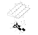
対空標識1の形状は、上述のような正三角錐に限らず他の三角錐、或いは、三角錐以上の多角錐形状であっても良い。また、円錐であっても良い。図7は、対空標識1の形状を四角錐とした場合について示したものである。この場合、対空標識1は矩形の面S5を接地面、即ち底面として標識1を設置される。対空標識1の頂部Aから延びる各錐面S1~S4には、例えば、図7(a)に示すように、各面S1~S4において頂部Aから延長して対辺を2等分する直線により2つの領域に区画され、各領域は、隣接する領域同士が異なる色彩となるように白色又は黒色に着色される。また、他の配色として、図7(b)に示すように、領域を縦横に2分することにより、各面S1~S4を4つの領域に区画し、 隣接する領域同士が異なる色彩となるように白又は黒に着色しても良い。また、図7(c)に示すように、接地面となる面S5から頂部Aまでの高さを低くするようにしても良い。
なお、上記説明では、図1,図7に示した対空標識1は、頂部が鋭角や鈍角等の角状の頂部を有するように示してあるが、頂部の形状は、角状の頂部に限定されず、球状に丸められたものであっても良い。また、対空標識1は、頂部が平面状の錐台形状であっても良い。
A~D 頂部、F 稜線、L 境界線、P 境界点、S1~S4 (錐)面。
Claims (3)
- 空中写真測量における標定点として設けられる多角錘形状の対空標識であって、
前記錐体の錐面を構成するそれぞれの頂点から延長し、対辺を2等分する直線により複数の領域に区画され、互いに隣接する領域同士の色彩が異なることを特徴とする対空標識。 - 前記錐体の頂部に地上測量用のターゲットを備えたことを特徴とする請求項1記載の対空標識。
- 前記多角錘形状における接地面は、複数の領域に区画され、互いに隣接する領域同士の色彩が異なることを特徴とする請求項1又は請求項2に記載の対空標識。
Priority Applications (1)
| Application Number | Priority Date | Filing Date | Title |
|---|---|---|---|
| JP2017199852A JP6991827B2 (ja) | 2017-10-13 | 2017-10-13 | 対空標識 |
Applications Claiming Priority (1)
| Application Number | Priority Date | Filing Date | Title |
|---|---|---|---|
| JP2017199852A JP6991827B2 (ja) | 2017-10-13 | 2017-10-13 | 対空標識 |
Publications (2)
| Publication Number | Publication Date |
|---|---|
| JP2019074386A JP2019074386A (ja) | 2019-05-16 |
| JP6991827B2 true JP6991827B2 (ja) | 2022-01-13 |
Family
ID=66543993
Family Applications (1)
| Application Number | Title | Priority Date | Filing Date |
|---|---|---|---|
| JP2017199852A Active JP6991827B2 (ja) | 2017-10-13 | 2017-10-13 | 対空標識 |
Country Status (1)
| Country | Link |
|---|---|
| JP (1) | JP6991827B2 (ja) |
Families Citing this family (4)
| Publication number | Priority date | Publication date | Assignee | Title |
|---|---|---|---|---|
| JP7161298B2 (ja) * | 2018-03-26 | 2022-10-26 | 株式会社トプコン | ターゲット装置、測量システム |
| CN110186432A (zh) * | 2019-07-08 | 2019-08-30 | 中国电建集团成都勘测设计研究院有限公司 | 用于地表变形演化的地面控制点布设装置 |
| KR102108756B1 (ko) * | 2019-12-02 | 2020-05-11 | 대한민국 | 부채형태로 변형 가능한 대공표지 |
| JP7362524B2 (ja) * | 2020-03-19 | 2023-10-17 | 戸田建設株式会社 | マーカ、検出方法および検出プログラム |
Citations (2)
| Publication number | Priority date | Publication date | Assignee | Title |
|---|---|---|---|---|
| JP2003023561A (ja) | 2001-07-06 | 2003-01-24 | Minolta Co Ltd | 測定装置 |
| JP2017138109A (ja) | 2016-02-01 | 2017-08-10 | 三菱マテリアルテクノ株式会社 | 空中写真測量および三次元立体モデル生成用標識、空中写真測量方法 |
-
2017
- 2017-10-13 JP JP2017199852A patent/JP6991827B2/ja active Active
Patent Citations (2)
| Publication number | Priority date | Publication date | Assignee | Title |
|---|---|---|---|---|
| JP2003023561A (ja) | 2001-07-06 | 2003-01-24 | Minolta Co Ltd | 測定装置 |
| JP2017138109A (ja) | 2016-02-01 | 2017-08-10 | 三菱マテリアルテクノ株式会社 | 空中写真測量および三次元立体モデル生成用標識、空中写真測量方法 |
Also Published As
| Publication number | Publication date |
|---|---|
| JP2019074386A (ja) | 2019-05-16 |
Similar Documents
| Publication | Publication Date | Title |
|---|---|---|
| JP6991827B2 (ja) | 対空標識 | |
| Vallet et al. | Photogrammetric performance of an ultra light weight swinglet" UAV" | |
| CN102074047B (zh) | 一种高精细城市三维建模方法 | |
| CN107656259B (zh) | 外场环境标定的联合标定系统与方法 | |
| Themistocleous et al. | More than a flight: the extensive contributions of UAV flights to archaeological research–the case study of curium site in Cyprus | |
| Tahar et al. | A simulation study on the capabilities of rotor wing unmanned aerial vehicle in aerial terrain mapping | |
| CN111707238A (zh) | 一种生成航空数字正射影像图的方法及系统 | |
| JP2012137933A (ja) | 被写地物の位置特定方法とそのプログラム、及び表示地図、並びに撮影位置取得方法とそのプログラム、及び撮影位置取得装置 | |
| CN108931235A (zh) | 无人机倾斜摄影测量技术在规划竣工测量中的应用方法 | |
| Sužiedelytė Visockienė et al. | Comparison of UAV images processing softwares | |
| KR900700851A (ko) | 자연 공간들에서 다차원의 구조들의 매개 변수의 큰척도에 의한 측량법 | |
| Maiellaro et al. | Laser scanner and camera-equipped UAV architectural surveys | |
| Kurkov et al. | DEM accuracy research based on unmanned aerial survey data | |
| US20190204417A1 (en) | Ground control target | |
| Redweik | Photogrammetry | |
| Nasrullah | Systematic analysis of unmanned aerial vehicle (UAV) derived product quality | |
| Ballarin et al. | Integrated surveying techniques for sensitive areas: San Felice sul Panaro | |
| Hlotov et al. | Accuracy investigation of creating orthophotomaps based on images obtained by applying Trimble-UX5 UAV | |
| JP6296444B2 (ja) | 点群画像による図化方法、及び点群画像による図化装置 | |
| Kattan et al. | 3D modelling and visualization of large building using photogrammetric approach | |
| Rönnholm et al. | Registration of laser scanning point clouds and aerial images using either artificial or natural tie features | |
| CN113514037A (zh) | 基于便携无人机摄影筛查的岩体露头测量方法 | |
| JP6730502B1 (ja) | 点群分布可視化装置、点群分布可視化方法および点群分布可視化プログラム | |
| JP7703246B2 (ja) | オルソ画像作成方法、オルソ画像作成システム、3次元モデル作成方法、3次元モデル作成システム及びそれに使用される標識 | |
| ABDULRAHMAN et al. | A comparison between unmanned aerial vehicle and aerial survey acquired in separate dates for the production of orthophotos |
Legal Events
| Date | Code | Title | Description |
|---|---|---|---|
| A621 | Written request for application examination |
Free format text: JAPANESE INTERMEDIATE CODE: A621 Effective date: 20200915 |
|
| A977 | Report on retrieval |
Free format text: JAPANESE INTERMEDIATE CODE: A971007 Effective date: 20210714 |
|
| A131 | Notification of reasons for refusal |
Free format text: JAPANESE INTERMEDIATE CODE: A131 Effective date: 20210720 |
|
| A521 | Written amendment |
Free format text: JAPANESE INTERMEDIATE CODE: A523 Effective date: 20210921 |
|
| TRDD | Decision of grant or rejection written | ||
| A01 | Written decision to grant a patent or to grant a registration (utility model) |
Free format text: JAPANESE INTERMEDIATE CODE: A01 Effective date: 20211207 |
|
| A61 | First payment of annual fees (during grant procedure) |
Free format text: JAPANESE INTERMEDIATE CODE: A61 Effective date: 20211208 |
|
| R150 | Certificate of patent or registration of utility model |
Ref document number: 6991827 Country of ref document: JP Free format text: JAPANESE INTERMEDIATE CODE: R150 |