JP2012127791A - Navigation device and control method therefor and program - Google Patents
Navigation device and control method therefor and program Download PDFInfo
- Publication number
- JP2012127791A JP2012127791A JP2010279312A JP2010279312A JP2012127791A JP 2012127791 A JP2012127791 A JP 2012127791A JP 2010279312 A JP2010279312 A JP 2010279312A JP 2010279312 A JP2010279312 A JP 2010279312A JP 2012127791 A JP2012127791 A JP 2012127791A
- Authority
- JP
- Japan
- Prior art keywords
- district
- display
- displayed
- item
- navigation device
- Prior art date
- Legal status (The legal status is an assumption and is not a legal conclusion. Google has not performed a legal analysis and makes no representation as to the accuracy of the status listed.)
- Pending
Links
Images


Abstract
Description
本発明は、ナビゲーション装置およびその制御方法並びにプログラムに関し、詳しくは、地図情報を記憶する情報記憶手段と、情報記憶手段に記憶された地図情報を用いて地図画像を表示する表示手段と、表示手段に表示された地図画像の操作を行なう操作手段とを備え、住所の選択により目的地を入力可能な車載用のナビゲーション装置およびその制御方法並びにプログラムに関する。 The present invention relates to a navigation device, a control method thereof, and a program, and more specifically, information storage means for storing map information, display means for displaying a map image using map information stored in the information storage means, and display means. It is related with the vehicle-mounted navigation apparatus which can input the destination by selection of an address, its control method, and a program.
従来、この種のナビゲーション装置としては、住所の選択により車両の目的地等を検索する際に、日本全体等の第1階層の地図を表示すると共にその下位の都道府県等の第2階層の地点名称をリスト表示し、リストから第2階層の地点名称を選択させるものが提案されている(例えば、特許文献1参照)。また、この種の地図表示を行なう装置の住所選択に関する技術として、都道府県や市町村等の各行政区画の入力項目を例えばあいうえお順に表示されるリストから選択するときに、前回選択された行政区画名称を優先して表示するものも提案されている(例えば、特許文献2参照)。 Conventionally, as a navigation device of this type, when searching for a destination or the like of a vehicle by selecting an address, a map of the first layer such as the whole of Japan is displayed and a point of the second layer such as a prefecture below it is displayed. There has been proposed a technique for displaying names in a list and selecting point names in the second hierarchy from the list (see, for example, Patent Document 1). In addition, as a technology related to address selection for this type of map display device, when selecting the input items of each administrative division such as prefectures and municipalities from a list displayed in order, for example, the administrative division name selected last time Has also been proposed (for example, see Patent Document 2).
しかしながら、上述の装置では、住所の選択により目的地を検索する際に都道府県名等の文字列(例えば「愛知県」)をリストから選択する必要があるため、複数の名称(例えば「静岡県」「愛知県」「岐阜県」「三重県」)が並んだリストから住所を選択する場合など、視覚的に住所を把握することが難しく容易に選択することができない場合があった。 However, in the above-described apparatus, when searching for a destination by selecting an address, it is necessary to select a character string such as a prefecture name (for example, “Aichi Prefecture”) from the list. "Aichi Prefecture" "Gifu Prefecture" "Mie Prefecture"), there are cases where it is difficult to grasp the address visually and cannot be easily selected.
本発明のナビゲーション装置およびその制御方法並びにプログラムは、目的地を入力する際に住所の選択を視覚的により容易に行なえるようにすることを主目的とする。 The main purpose of the navigation apparatus, its control method, and program of the present invention is to make it easier to visually select an address when inputting a destination.
本発明のナビゲーション装置およびその制御方法並びにプログラムは、上述の主目的を達成するために以下の手段を採った。 The navigation device, the control method thereof, and the program according to the present invention employ the following means in order to achieve the main object described above.
本発明のナビゲーション装置は、
地図情報を記憶する情報記憶手段と、前記情報記憶手段に記憶された地図情報を用いて地図画像を表示する表示手段と、前記表示手段に表示された地図画像の操作を行なう操作手段とを備え、住所の選択により目的地を入力可能な車載用のナビゲーション装置であって、
前記操作手段による操作に基づいて階層化された行政区画における一階層の一地区を選択する地区選択手段と、
前記地区選択手段により選択された一地区である選択地区が表示されるよう前記表示手段を制御する表示制御手段とを備え、
前記地区選択手段は、前記表示手段に前記選択地区が表示されているときに前記操作手段により方向指示操作が行なわれたときには、前記行政区画における前記選択地区と同一階層の複数の地区のうち該選択地区に対して前記方向指示操作の指示方向にある一地区を選択する手段であり、
前記表示制御手段は、選択地区を内包する最小の矩形の四辺と前記表示手段の画面の外縁との間に少なくとも所定のマージンが確保される最大のサイズで前記選択地区が前記表示手段の画面中央に表示されるよう前記表示手段を制御する手段である、
ことを特徴とする。
The navigation device of the present invention
Information storage means for storing map information, display means for displaying a map image using map information stored in the information storage means, and operation means for operating the map image displayed on the display means An in-vehicle navigation device capable of inputting a destination by selecting an address,
District selecting means for selecting one district in one hierarchy in the administrative divisions hierarchized based on the operation by the operating means;
Display control means for controlling the display means so that a selected district that is one district selected by the district selection means is displayed;
When the direction selection operation is performed by the operation means when the selected area is displayed on the display means, the district selecting means is a plurality of districts of the same district as the selected district in the administrative district. A means for selecting one district in the direction indicated by the direction indicating operation with respect to the selected district,
The display control means is configured such that the selected area is at the center of the screen of the display means with a maximum size that ensures at least a predetermined margin between the four sides of the smallest rectangle containing the selected area and the outer edge of the screen of the display means. Means for controlling the display means to be displayed on
It is characterized by that.
この本発明のナビゲーション装置では、階層化された行政区画における一階層の選択された一地区である選択地区が表示手段に表示されているときに、操作手段により方向指示操作が行なわれたときには、行政区画における選択地区と同一階層の複数の地区のうち選択地区に対して方向指示操作の指示方向にある一地区を選択する。そして、選択地区を内包する最小の矩形の四辺と表示手段の画面の外縁との間に少なくとも所定のマージンが確保される最大のサイズで選択地区が表示手段の画面中央に表示されるよう表示手段を制御する。したがって、表示手段に選択地区が表示されているときに方向指示操作によって一地区が選択されると、その一地区を選択地区として表示手段の画面中央に表示するから、選択地区の地図上の大きさや形状に拘わらず表示手段の画面に対して視認しやすい状態で選択地区を表示させることができる。また、こうして表示手段に選択地区が表示されると、再び方向指示操作によって一地区の選択が可能となるから、表示手段の画面に対して選択地区毎に視認しやすい状態で選択地区を順次表示させることができる。この結果、住所の選択を視覚的により容易に行なえるようにすることができる。ここで、所定のマージンは、表示手段の画面の外縁からの長さとして予め定められたものとしてもよいし、表示手段の画面が矩形状の場合には画面の各辺の長さに対する予め定められた割合に相当する長さとしてもよいし、値0としてもよい。 In the navigation device of the present invention, when a direction indication operation is performed by the operation means when the selected area, which is a selected one area of the hierarchy in the hierarchized administrative district, is displayed on the display means, One district in the direction indicated by the direction instruction operation is selected from the plurality of districts at the same level as the selected district in the administrative district. The display means displays the selected area in the center of the screen of the display means with a maximum size that ensures at least a predetermined margin between the four sides of the smallest rectangle containing the selected area and the outer edge of the screen of the display means. To control. Therefore, if a district is selected by the direction indication operation when the selected area is displayed on the display means, that area is displayed as the selected area in the center of the display means. Regardless of the sheath shape, the selected district can be displayed in a state where it can be easily seen on the screen of the display means. In addition, when the selected area is displayed on the display means in this manner, it becomes possible to select one area again by the direction instruction operation. Can be made. As a result, it is possible to make it easier to select an address visually. Here, the predetermined margin may be determined in advance as a length from the outer edge of the screen of the display unit. When the screen of the display unit is rectangular, the predetermined margin is predetermined with respect to the length of each side of the screen. It may be a length corresponding to the ratio obtained, or may be 0.
こうした本発明のナビゲーション装置において、前記操作手段は、前記表示手段の画面に取り付けられたタッチパネルであり、前記地区選択手段は、前記方向指示操作として操作者による前記タッチパネルのフリック操作が行なわれたときには、前記フリック操作の操作速度が速いほど前記行政区画における前記選択地区と同一階層の複数の地区のうち該選択地区に対して前記フリック操作の操作方向とは反対の指示方向にある遠方の一地区を選択する手段である、ものとすることもできる。こうすれば、タッチパネルのフリック操作の操作速度に応じて次に表示手段の画面中央に表示すべき一地区を選択することができる。この結果、住所の選択を視覚的に行なう際の操作性を向上させることができる。 In such a navigation apparatus of the present invention, the operation means is a touch panel attached to the screen of the display means, and the district selection means is configured to perform a flick operation of the touch panel by an operator as the direction instruction operation. The higher the operation speed of the flick operation, the farther one district in the indicated direction opposite to the operation direction of the flick operation with respect to the selected district among a plurality of districts in the same hierarchy as the selected district in the administrative district It is also possible to be a means for selecting. By doing this, it is possible to select one area to be displayed next in the center of the screen of the display means in accordance with the operation speed of the flick operation of the touch panel. As a result, operability when visually selecting an address can be improved.
本発明のナビゲーション装置において、前記表示制御手段は、前記選択地区を前記表示手段の画面中央に表示するという制約の範囲内で前記選択地区外に前記行政区画における該選択地区と同一階層の該選択地区に近接する各地区が少なくとも該各地区間の境界および該選択地区との境界と共に表示されるよう前記表示手段を制御する手段である、ものとすることもできる。こうすれば、選択地区と同一階層の他の地区の選択を視覚的により容易に行なえるようにすることができる。ここで、「近接する各地区」には、地続きで隣接する各地区が含まれ、「境界」には、地続きの地区間の境界線や地続きでない海洋により隔てられた地区間に存在する海岸線などが含まれる。また、境界に加えて、選択地区に近接する各地区の全部または一部の名称を表示してもよい。 In the navigation device according to the present invention, the display control means may select the selection in the same hierarchy as the selected area in the administrative district outside the selected area within a constraint that the selected area is displayed in the center of the screen of the display means. The display means may be a means for controlling the display means so that each area adjacent to the area is displayed together with at least the boundary of each section and the boundary with the selected area. In this way, it is possible to make it easier to visually select other districts in the same hierarchy as the selected district. Here, “adjacent districts” include districts that are adjacent to each other, and “boundaries” exist between districts separated by boundaries between consecutive districts or non-continuous oceans. Shoreline to be included. Further, in addition to the boundary, the names of all or part of the districts close to the selected district may be displayed.
また、表示手段の画面にタッチパネルを取り付ける態様の本発明のナビゲーション装置において、前記地区選択手段は、前記表示手段に表示されている前記選択地区内で操作者により前記タッチパネルのタップ操作が行なわれたときには、前記タップ操作のタップ位置に対応する前記選択地区より1つ下の階層の一地区を選択する手段である、ものとすることもできる。こうすれば、タッチパネルのタップ操作によって次に表示手段の画面中央に表示すべき一地区として選択地区より1つ下の階層の一地区を選択することができる。この結果、住所を絞り込んで選択可能とすることができる。 Further, in the navigation device of the present invention in which a touch panel is attached to the screen of the display means, the district selecting means is tapped on the touch panel by an operator within the selected district displayed on the display means. In some cases, it may be a means for selecting one district one level below the selected district corresponding to the tap position of the tap operation. By doing this, it is possible to select one district one level below the selected district as one district to be displayed next in the center of the screen of the display means by a tap operation on the touch panel. As a result, the address can be narrowed down and selectable.
このタッチパネルのタップ操作によって選択地区より1つ下の階層の一地区を選択する態様の本発明のナビゲーション装置において、前記表示制御手段は、前記選択地区内に前記行政区画における該選択地区より1つ下の階層の複数の地区が少なくとも該複数の地区間の境界および該選択地区との境界と共に表示されるよう前記表示手段を制御する手段である、ものとすることもできる。こうすれば、選択地区より1つ下の階層の地区の選択を視覚的により容易に行なえるようにすることができる。ここで、「境界」には、地続きの地区間の境界線や地続きでない海洋により隔てられた地区間に存在する海岸線などが含まれる。また、境界に加えて、選択地区より1つ下の階層の複数の地区の全部または一部の名称を表示してもよい。 In the navigation device of the present invention in which one area one level lower than the selected area is selected by a tap operation on the touch panel, the display control means is one in the selected area from the selected area in the administrative area. The display means may be a means for controlling the display means so that a plurality of districts in a lower hierarchy are displayed together with at least a boundary between the plurality of districts and a boundary with the selected district. In this way, it is possible to make it easier to visually select an area one level below the selected area. Here, the “boundary” includes a boundary line between continuous districts, a coastline existing between districts separated by non-continuous oceans, and the like. Further, in addition to the boundary, the names of all or part of a plurality of districts one level below the selected district may be displayed.
さらに、表示手段の画面にタッチパネルを取り付ける態様の本発明のナビゲーション装置において、前記地区選択手段は、前記表示手段に表示されている前記選択地区外で操作者により前記タッチパネルのタップ操作が行なわれたときには、前記タップ操作のタップ位置に対応する前記選択地区と同一階層の一地区を選択する手段である、ものとすることもできる。こうすれば、タッチパネルのフリック操作による選択に加えて、タッチパネルのタップ操作によっても選択地区と同一階層の他の地区を選択することができる。この結果、住所の選択を視覚的に行なう際の操作性を向上させることができる。 Furthermore, in the navigation device of the present invention in which the touch panel is attached to the screen of the display means, the area selection means is tapped on the touch panel by an operator outside the selected area displayed on the display means. Sometimes, it may be means for selecting one district in the same hierarchy as the selected district corresponding to the tap position of the tap operation. If it carries out like this, in addition to the selection by the flick operation of a touch panel, the other area of the same hierarchy as a selection area can be selected also by the tap operation of a touch panel. As a result, operability when visually selecting an address can be improved.
本発明のナビゲーション装置の制御方法は、
地図情報を記憶する情報記憶手段と、前記情報記憶手段に記憶された地図情報を用いて地図画像を表示する表示手段と、前記表示手段に表示された地図画像の操作を行なう操作手段とを備え、住所の選択により目的地を入力可能で、操作手段による操作に基づいて階層化された行政区画における一階層の一地区を選択し、前記選択された一地区である選択地区が表示されるよう前記表示手段を制御する車載用のナビゲーション装置の制御方法であって、
(a)前記表示手段に前記選択地区が表示されているときに前記操作手段により方向指示操作が行なわれたときには、前記行政区画における前記選択地区と同一階層の複数の地区のうち該選択地区に対して前記方向指示操作の指示方向にある一地区を選択し、
(b)選択地区を内包する最小の矩形の四辺と前記表示手段の画面の外縁との間に少なくとも所定のマージンが確保される最大のサイズで前記選択地区が前記表示手段の画面中央に表示されるよう前記表示手段を制御する、
ことを特徴とする。
The navigation apparatus control method of the present invention includes:
Information storage means for storing map information, display means for displaying a map image using map information stored in the information storage means, and operation means for operating the map image displayed on the display means The destination can be input by selecting the address, and one district in the hierarchical administrative district is selected based on the operation by the operation means, and the selected district that is the selected one district is displayed. A control method for an in-vehicle navigation device for controlling the display means,
(A) When a direction instruction operation is performed by the operation means while the selected area is displayed on the display means, the selected area is selected from a plurality of areas in the same level as the selected area in the administrative district. Select a district in the direction indicated by the direction indication operation
(B) The selected area is displayed in the center of the display means with the maximum size that ensures at least a predetermined margin between the four sides of the smallest rectangle containing the selected area and the outer edge of the display means screen. Controlling the display means to
It is characterized by that.
この本発明のナビゲーション装置の制御方法では、階層化された行政区画における一階層の選択された一地区である選択地区が表示手段に表示されているときに、操作手段により方向指示操作が行なわれたときには、行政区画における選択地区と同一階層の複数の地区のうち選択地区に対して方向指示操作の指示方向にある一地区を選択する。そして、選択地区を内包する最小の矩形の四辺と表示手段の画面の外縁との間に少なくとも所定のマージンが確保される最大のサイズで選択地区が表示手段の画面中央に表示されるよう表示手段を制御する。したがって、表示手段に選択地区が表示されているときに方向指示操作によって一地区が選択されると、その一地区を選択地区として表示手段の画面中央に表示するから、選択地区の地図上の大きさや形状に拘わらず表示手段の画面に対して視認しやすい状態で選択地区を表示させることができる。また、こうして表示手段に選択地区が表示されると、再び方向指示操作によって一地区の選択が可能となるから、表示手段の画面に対して選択地区毎に視認しやすい状態で選択地区を順次表示させることができる。この結果、住所の選択を視覚的により容易に行なえるようにすることができる。ここで、所定のマージンは、表示手段の画面の外縁からの長さとして予め定められたものとしてもよいし、表示手段の画面が矩形状の場合には画面の各辺の長さに対する予め定められた割合に相当する長さとしてもよい。 In this navigation device control method of the present invention, the direction indication operation is performed by the operating means when the selected area, which is the selected one area of the one hierarchy in the hierarchized administrative district, is displayed on the display means. If the selected district is the same as the selected district in the administrative district, one district in the direction of the direction instruction operation is selected from the plurality of districts in the same hierarchy. The display means displays the selected area in the center of the screen of the display means with a maximum size that ensures at least a predetermined margin between the four sides of the smallest rectangle containing the selected area and the outer edge of the screen of the display means. To control. Therefore, if a district is selected by the direction indication operation when the selected area is displayed on the display means, that area is displayed as the selected area in the center of the display means. Regardless of the sheath shape, the selected district can be displayed in a state where it can be easily seen on the screen of the display means. In addition, when the selected area is displayed on the display means in this manner, it becomes possible to select one area again by the direction instruction operation, so the selected area is sequentially displayed on the screen of the display means in a state that is easily visible for each selected area. Can be made. As a result, it is possible to make it easier to select an address visually. Here, the predetermined margin may be determined in advance as a length from the outer edge of the screen of the display unit. When the screen of the display unit is rectangular, the predetermined margin is predetermined with respect to the length of each side of the screen. The length corresponding to the ratio obtained may be used.
本発明のプログラムは、上述したナビゲーション装置の制御方法の各ステップを1又は複数のコンピュータに実現させるためのものである。このプログラムは、コンピュータが読み取り可能な記録媒体(例えばハードディスクやフラッシュメモリ,ROM,CD,DVDなど)に記録されていてもよいし、伝送媒体(インターネットやLANなどの通信網)を介してあるコンピュータから別のコンピュータへ配信されてもよいし、その他どのような形で授受されてもよい。このプログラムを一つのコンピュータに実行させるか又は複数のコンピュータに各ステップを分担して実行させれば、上述したナビゲーション装置の制御方法の各ステップが実行されるため、その制御方法と同様の作用効果が得られる。 The program of the present invention is for causing one or more computers to implement the steps of the above-described navigation apparatus control method. This program may be recorded on a computer-readable recording medium (for example, a hard disk, flash memory, ROM, CD, DVD, etc.), or a computer via a transmission medium (communication network such as the Internet or LAN). May be distributed to another computer, or may be exchanged in any other form. If this program is executed by one computer or if each computer is caused to share and execute each step, each step of the above-described navigation device control method is executed. Is obtained.
次に、本発明を実施するための形態を実施例を用いて説明する。 Next, the form for implementing this invention is demonstrated using an Example.
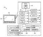
図1は、本発明の一実施例としてのナビゲーション装置20の構成の概略を示す構成図である。ナビゲーション装置20は、図示するように、文字や画像を表示する矩形状の画面を有する例えば液晶ディスプレイとして構成されたディスプレイ22と、ディスプレイ22の画面に取り付けられた抵抗膜方式や静電容量方式などによるタッチパネル24と、装置全体をコントロールする電子制御ユニット30と、各種アプリケーションソフトウェアや地図データなどを記憶する大容量メモリとしてのハードディスクドライブ(以下、HDDという)40とを備え、図示しない自動車に搭載されて車載バッテリからの電力供給を受けて作動する。
FIG. 1 is a configuration diagram showing an outline of a configuration of a
電子制御ユニット30は、CPU32を中心とするマイクロプロセッサとして構成されており、CPU32の他に各種処理プログラムを記憶するROM34と、データを一時的に記憶するRAM36と、記憶したデータを保持する不揮発性のフラッシュメモリ38と、図示しない入出力ポートおよび通信ポートとを備える。電子制御ユニット30には、操作者のタッチ位置を検出するタッチパネル24からの信号やHDD40から読み出したデータ,GPS(Global Positioning System)衛星からの信号をGPSアンテナを介して受信するGPS受信機50からの信号,車両の進行方向やその変化を検出する例えばジャイロセンサにより構成された方位センサ52からの信号などが入力ポートを介して入力されている。電子制御ユニット30からは、ディスプレイ22への表示信号やアンプを内蔵したスピーカ26への音声信号,HDD40に書き込むデータなどが出力ポートを介して出力されている。また、電子制御ユニット30は、車両全体をコントロールする図示しない車両用電子制御ユニットと通信ポートを介して接続されており、例えば車速パルス信号などの車両の状態に関するデータを通信により入力すると共に必要に応じてナビゲーション装置20の状態に関するデータを通信により出力する。
The
実施例のナビゲーション装置20では、電子制御ユニット30は、HDD40から必要なアプリケーションソフトウェアや地図データを読み出して各種処理を実行する。例えば、図1の機能ブロックに示すように、GPS受信機50からの信号や方位センサ52からの信号に基づいて車両の現在位置を特定するロケーション処理部60によるロケーション処理、ディスプレイ22に道路を含む地図画像を表示する地図表示処理部62による地図表示処理,操作者によるタッチパネル24の操作に基づいて目的地を入力する目的地入力処理部64による目的地入力処理、目的地への走行ルートを探索して地図表示処理部62による地図表示やスピーカ26からの音声出力によりルート案内を行なうナビゲーション処理部68によるナビゲーション処理などの各種処理を実行する。また、詳細は後述するが、目的地入力処理部64には、ディスプレイ22に地図画像を表示する制御を実行する表示制御部65や地図画像における一地区の選択処理を実行する地区選択部66,他の制御部などが含まれる。なお、実施例のHDD40に記憶された地図データには、観光情報や駐車場などの施設情報および道路情報などがデータベース化されて記憶されると共に予め定められた複数の縮尺で地図表示を可能とする地図表示処理用のデータ(以下、表示用地図データという)と、国や州,省,都道府県,市区町村等の階層化された行政区画の形状を認識可能なポリゴンにより住所選択を可能とする目的地入力処理用のデータ(以下、住所選択用地図データという)とが含まれる。また、道路情報には、距離情報や幅員情報,地域情報(市街地,郊外),種別情報(一般道路,高速道路),勾配情報,法定速度,信号機の数などが含まれる。
In the
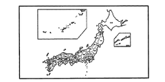
次に、こうして構成された実施例のナビゲーション装置20の動作、特に住所の選択により目的地を入力する際の動作について説明する。図2は、電子制御ユニット30の目的地入力処理部64により実行される住所選択用目的地入力処理ルーチンの一例を示すフローチャートである。このルーチンは、住所選択による目的地の入力が指示されたとき以降、タッチパネル24が操作されたときに実行される。図3に目的地入力開始用画面の一例を示す。図3の例では、「住所」ボタン70が操作されたときにこのルーチンが実行される。
Next, the operation of the
図2の住所選択用目的地入力処理ルーチンが実行されると、電子制御ユニット30のCPU32は、まず、住所選択用の目的地の入力処理に際して初期表示が完了したときに値1が設定され初期値としては値0が設定される初期表示完了フラグFの値を調べ(ステップS100)、初期表示完了フラグFが値0のとき、即ち目的地入力開始用画面で例えば「住所」ボタン70が操作されて本ルーチンが最初に実行されたときには、車両の現在位置を入力すると共に(ステップS110)、行政区画における一階層を住所選択の対象となっている現在の階層である現在階層に設定する処理を実行する(ステップS120)。ここで、現在位置は、ロケーション処理により特定された座標(緯度,経度)を入力することができる。また、現在階層は、予め定められた階層(例えば、国階層や都道府県階層など)に設定することができ、実施例では、都道府県階層に設定するものとした。
When the address selection destination input routine shown in FIG. 2 is executed, the CPU 32 of the
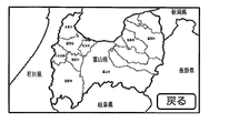
こうしてデータを入力し設定すると、入力した現在位置を含む現在階層の地区アイテムを最初に選択された地区であるとみなして選択アイテムに設定し(ステップS130)、設定した選択アイテムをディスプレイ22の画面中央に表示するためにHDD40に記憶された住所選択用地図データを用いてポリゴンと地区名称とにより地図表示を行なう初期設定時表示制御を実行して(ステップS140)、住所選択用目的地入力処理ルーチンを終了する。ここで、住所選択用目的地入力処理の説明を一旦中断し、初期設定次表示制御について説明する。図4は初期設定時表示制御ルーチンの一例を示すフローチャートであり、図5は選択アイテムとして「愛知県」が設定されたときの地図表示の様子の一例を説明する説明図である。
When the data is input and set in this manner, the district item in the current hierarchy including the input current position is regarded as the district selected first (step S130), and the set selection item is displayed on the screen of the
図4のルーチンでは、画面表示に適した座標(緯度,経度)と縮尺として選択アイテム毎に予め定められた中心座標と縮尺データとを入力し(ステップS400)、HDD40に記憶された住所選択用地図データを用いて、ディスプレイ22の画面の中心と入力した選択アイテムの中心座標とが合うように且つ入力した選択アイテムの縮尺データの縮尺となるように北方向を画面上方に向けて(いわゆるノースアップで)ディスプレイ22に地図画像を表示し(ステップS410)、初期表示完了フラグFに値1を設定して(ステップS420)、初期設定時表示制御ルーチンを終了する。選択アイテムの中心座標は、実施例では、住所選択用地図データのポリゴンにより表された選択アイテムを内包する最小の矩形の対角線の交点などとして定められ、選択用地図データの一部に含まれてHDD40に記憶されたものを用いるものとした。また、選択アイテムの縮尺データは、実施例では、図5に示すように選択アイテム(図5では「愛知県」)を内包する最小の矩形の四辺とディスプレイ22の矩形状の画面の対応する四辺との間に少なくとも所定のマージンαが確保される最大のサイズの縮尺として予め定められ、選択用地図データの一部に含まれてHDD40に記憶されたものを用いるものとした。所定のマージンαは、ディスプレイ22の矩形状の画面の各辺からの長さ(例えば、数mmや数cmなど)としても定めてもよいし、画面の各辺の長さに対する所定割合(例えば、数%や十数%など)の長さとして定めてもよいし、値0としてもよい。実施例では、選択アイテムを画面中央に表示する際には、図5に示すように、選択アイテムの領域外に選択アイテムと同一階層の地区アイテム(図5では「三重県」「滋賀県」「岐阜県」「長野県」「静岡県」即ち「愛知県」に近接する各県)をこれら地区アイテム間の境界と共に表示し、選択アイテムの領域内に選択アイテムより1つ下の階層(図5では市町村階層)の複数の地区アイテムをこれら複数の地区アイテム間の境界と共に表示するものとした。さらに、選択アイテムを画面中央に表示する際には、選択アイテムと同一階層の地区アイテムの名称と、選択アイテムの領域内の選択アイテムより1つ下の階層の主要な地区アイテムの名称(例えば、市町村のうち市の名称や面積が比較的広い地区の名称など)とを表示するものとした。なお、図5では「愛知県」に地続きで近接する各県を表示したが、場合によっては「北海道」などの海洋を隔てて近接する県が表示される。また、図5中「戻る」ボタン72は、現在階層より1つ上の階層(例えば都道府県階層より1つ上の国階層)から選択アイテムを設定するためのものであり、「戻る」ボタン72が操作されると現在階層より1つ上の階層の地区アイテムを選択アイテムに設定すると共に設定した地区アイテムの階層が現在階層に設定される。図6に、図5で「戻る」ボタン72が操作されて現在階層と選択アイテムとして「国階層」と「日本国」とが選択されたときの地図表示の様子の一例を示す。以上、初期設定時表示制御について説明した。図2の住所選択用目的地入力処理の説明に戻る。
In the routine of FIG. 4, coordinates (latitude and longitude) suitable for screen display and center coordinates and scale data predetermined for each selected item are input as scales (step S400), and an address selection stored in the
こうして最初の選択アイテムを画面中央に表示する処理を実行すると、次に本ルーチンを実行したときにステップS100で初期表示完了フラグFは値1であると判定され、タッチパネル24の操作がドラッグ操作の開始であるかフリック操作であるかタップ操作であるかを判定する(ステップS150)。ここで、ドラッグ操作は、タッチパネル24を指やペンなどの指示デバイス(以下、指等という)で押圧した状態で指等を移動させてから指等をタッチパネル24から離す操作であり、フリック操作は、タッチパネル24を指等で弾くような操作であり、タップ操作は、タッチパネル24を指等で軽くたたく操作である。各操作は周知の手法により検出することができる。例えばタップ操作は、タッチパネル24を予め定められた時間閾値(例えば数百msec)未満の時間に亘って押圧すると共に予め定められた長さ閾値(例えば数mm)未満の長さ範囲を移動する押圧操作として検出したり、フリック操作は、タッチパネル24を時間閾値未満の時間に亘って押圧すると共に長さ閾値以上の長さ範囲を移動する押圧操作として検出したり、ドラッグ操作の開始は、タッチパネル24が時間閾値以上の時間に亘って押圧されたときに検出したり、ドラッグ操作の終了は、ドラッグ操作の開始が検出された以降にタッチパネル24が押圧されなくなったときに検出したりすることができる。
When the process of displaying the first selected item in the center of the screen is executed in this way, the next time this routine is executed, the initial display completion flag F is determined to be 1 in step S100, and the operation of the
タッチパネル24の操作がドラッグ操作の開始であるときには、HDD40に記憶された住所選択用地図データを用いて、ディスプレイ22に表示されている地図画像をタッチパネル24の操作方向に沿って所定時間(ドラッグ操作の終了を制御上判定する時間間隔である例えば数十msec)に亘ってスクロールさせ(ステップS160)、ドラッグ操作が終了したか否かを判定し(ステップS170)、ドラッグ操作が終了していないときにはステップS160の処理に戻る。図7に、選択アイテムとして「愛知県」が設定されている状態でドラッグ操作により地図画像をスクロールさせたときの地図表示の変化の様子の一例を示す。図中、実線矢印はタッチパネル24上の指等の移動方向(ドラッグ操作の操作方向)と移動量とを示し、破線矢印はディスプレイ22での地図画像の移動方向と移動量とを示す。
When the operation of the
ドラッグ操作が終了したときには、現在階層の地区アイテムのうちディスプレイ22の画面の中心を含んで表示されている地区アイテムを選択アイテムに設定し(ステップS220)、設定した選択アイテムをディスプレイ22の画面中央に表示するためにHDD40に記憶された住所選択用地図データを用いてポリゴンと地区名称とにより地図表示を行なう選択時表示制御を実行して(ステップS320)、住所選択用目的地入力処理ルーチンを終了する。なお、実施例では、ドラッグ操作が終了したときにディスプレイ22の画面の中心が海上にある場合などディスプレイ22の画面の中心を含んで表示されている地区アイテムがないときには、ディスプレイ22の画面の中心に最も近い中心座標をもつ地区アイテムを選択アイテムに設定するものとした。ここで、住所選択用目的地入力処理の説明を再度中断し、選択時表示制御について説明する。図8は選択時表示制御ルーチンの一例を示すフローチャートであり、図9は選択アイテムとして「岐阜県」が設定されたときの地図表示の一例を説明する説明図である。
When the drag operation is completed, the district item displayed including the center of the screen of the
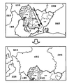
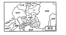
図8のルーチンでは、選択アイテムの中心座標と縮尺データとを入力し(ステップS500)、HDD40に記憶された住所選択用地図データを用いて、ディスプレイ22の画面の中心と入力した選択アイテムの中心座標とが合う方向にディスプレイ22に表示されている地図画像をスクロールさせ(ステップS510)、選択アイテムの縮尺データの縮尺となるように地図画像を拡大表示または縮小表示して(ステップS520)、選択時表示制御ルーチンを終了する。例えば、図7の地図表示の変化後の状態でドラッグ操作が終了すると選択アイテムが「愛知県」から「岐阜県」に代わり、図9に示すように、選択アイテムとしての「岐阜県」が画面中央に表示されるよう地図画像のスクロールに続けて縮尺変更が行なわれることになる。図9中、選択アイテムとしての「岐阜県」は、この「岐阜県」を内包する最小の矩形の四辺とディスプレイ22の矩形状の画面の対応する四辺との間に少なくとも所定のマージンαが確保される最大のサイズの縮尺で表示されている。また、選択アイテムとしての「岐阜県」の領域外には、選択アイテムと同一階層の選択アイテム以外の地区アイテムとして「愛知県」や「滋賀県」「京都府」「福井県」「石川県」「富山県」「長野県」「山梨県」などがこれら地区アイテム間の境界,これら地区アイテムと選択アイテムとの境界(図9では選択アイテムとしての「愛知県」の外縁),これらの地区アイテムの名称と共に表示されている。さらに、選択アイテムとしての「岐阜県」の領域内には、選択アイテムより1つ下の市町村階層の複数の地区アイテムがこれら複数の地区アイテム間の境界,これら複数の地区アイテムと選択アイテムとの境界(図9では選択アイテムとしての「愛知県」の外縁),これらのうち主要な地区アイテムの名称と共に表示されている。なお、図9の例において、選択アイテムとしての「岐阜県」の領域外の「三重県」と「静岡県」について各地区の一部が表示されていても各地区の名称については省略されている。実施例では、地図表示したときの見易さの観点からこうして名称の表示を省略することも行なうものとした。以上、選択時表示制御について説明した。図2の住所選択用目的地入力処理の説明に戻る。
In the routine of FIG. 8, the center coordinates and scale data of the selected item are input (step S500), and the center of the screen of the
タッチパネル24の操作がフリック操作であるときには、操作者によるフリック操作の操作速度に比例する初速度を地図画像を移動させる際の移動速度に設定し(ステップS180)、HDD40に記憶されている住所選択用地図データを用いて、設定した移動速度でディスプレイ22に表示されている地図画像をタッチパネル24の操作方向に所定時間(移動速度を制御上段階的に減速させる時間間隔である例えば数十msec)に亘ってスクロールさせ(ステップS190)、移動速度を予め定められた所定量だけ減速して設定し(ステップS200)、設定した移動速度が値0であるか否かを判定する(ステップS210)。フリック操作の操作速度は、タッチパネル24での指等の操作方向への単位時間あたりの移動量(例えば、タッチパネル24の押圧の開始から終了までの移動量をその移動に要した時間で割って得られる値)として検出され、フリック操作の操作速度に比例する初速度は、操作速度に換算係数を乗じることにより設定することができる。換算係数は、ディスプレイ22に表示されている地図画像を移動させるのに適した予め定められた範囲内で適宜定めることができる。また、所定量も地図画像を移動速度を減速させるのに適した値として適宜定めることができる。
When the operation of the
移動速度が値0でないときにはステップS190の処理に戻り、移動速度が値0であるときには、フリック操作による地図画像のスクロールが終了したと判断し、現在階層の地区アイテムのうちディスプレイ22の画面の中心を含んで表示されている地区アイテムを選択アイテムに設定し(ステップS220)、設定した選択アイテムをディスプレイ22の画面中央に表示するためにHDD40に記憶された住所選択用地図データを用いて選択時表示制御を実行して(ステップS320)、住所選択用目的地入力処理ルーチンを終了する。なお、実施例では、フリック操作による地図画像のスクロールが終了したときにディスプレイ22の画面の中心が海上にある場合などディスプレイ22の画面の中心を含んで表示されている地区アイテムがないときには、ドラッグ操作の終了時と同様に、ディスプレイ22の画面の中心に最も近い中心座標をもつ地区アイテムを選択アイテムに設定するものとした。図10に選択アイテムとして「愛知県」が設定されている状態で比較的遅いフリック操作により地図画像をスクロールさせたときの地図表示の変化の様子の一例を示し、図11に選択アイテムとして「愛知県」が設定されている状態で比較的速いフリック操作により地図画像をスクロールさせたときの地図表示の変化の様子の様子の一例を示し、図12にフリック操作により地図画像をスクロールさせた後に「愛知県」に代えて選択アイテムとして「富山県」が設定されたときの地図表示の様子の一例を示す。図10および図11の上段の図中、実線矢印はタッチパネル24上の指等の移動方向(フリック操作の操作方向)と移動量とを示し、破線矢印はディスプレイ22での地図画像の移動方向と地図画像の移動量を反映した量とを示す。また、図10および図11の中段の図中、破線矢印はディスプレイ22での地図画像の移動方向と移動量とを示す。図10に示すように、フリック操作による地図画像のスクロールが終了し停止すると(上段の図から中段の図への変化の様子を参照)、ディスプレイ22の画面の中心を含む地区アイテムとして「岐阜県」が選択アイテムに設定され、選択時表示制御の実行により、選択アイテムとしての「岐阜県」の中心座標を画面の中心に向けて移動させると共に(中段の図から下段の図への変化の様子を参照)、更に縮尺の変更が行なわれて図9に例示したように選択アイテムとしての「岐阜県」が画面中央に表示される。また、図11に示すように、図10の例より速いフリック操作による地図画像のスクロールが終了し停止すると(上段の図から中段の図への変化の様子を参照)、ディスプレイ22の画面の中心を含む地区アイテムとして「岐阜県」より遠方の「富山県」が選択アイテムに設定され、選択時表示制御の実行により、選択アイテムとしての「富山県」の中心座標を画面の中心に向けて移動させると共に(中段の図から下段の図への変化の様子を参照)、更に縮尺の変更が行なわれて図12に示すように選択アイテムとしての「富山県」が画面中央に表示される。このように、操作者によりタッチパネル24のフリック操作が行なわれたときには、フリック操作の操作速度が速いほど選択アイテムと同一階層の複数の地区アイテムのうち、選択アイテムに対してフリック操作の操作方向とは反対の方向にある遠方の地区アイテムが選択されることになる。なお、フリック操作の操作方向とは反対の方向は、選択アイテムから見て次にディスプレイ22の画面中央に表示すべき地区アイテムがある方向になるから、地区アイテムを選択するに際してはフリック操作の指示方向ということができる。また、フリック操作はこの指示方向を指定する方向指示操作ということができる。
If the moving speed is not 0, the process returns to step S190. If the moving speed is 0, it is determined that the scrolling of the map image by the flick operation has ended, and the center of the screen of the
タッチパネル24の操作がタップ操作であるときには、そのタップ操作が行なわれた位置(以下、タップ位置という)がディスプレイ22の画面上のボタンに対応する位置であるか否か、即ちそのタップ操作がボタン操作であるか否かを判定し(ステップS230)、ボタン操作ではないときには、タップ位置がディスプレイ22の画面上の選択アイテムの領域内に対応する位置であるか否かを判定する(ステップS240)。
When the operation of the
タップ位置が選択アイテムの領域外のときには、タップ位置に何らかの地区アイテムがあるか否かを判定し(ステップS250)、例えば海上などタップ位置に地区アイテムがないときには、そのまま住所選択用目的地入力処理ルーチンを終了し、タップ位置に地区アイテムがあるときには、現在階層の複数の地区アイテムのうちディスプレイ22の画面上でタップ位置に対応する位置を含む地区アイテムを選択アイテムに設定して(ステップS260)、住所選択用目的地入力処理ルーチンを終了する。例えば、図5の状態で「静岡県」の領域内でタップ操作が行なわれると「愛知県」に代えて「静岡県」が地区アイテムに設定されて、「静岡県」の縮尺データによる縮尺で「静岡県」が画面中央に表示される。
If the tap position is outside the area of the selected item, it is determined whether or not there is any district item at the tap position (step S250). For example, when there is no district item at the tap position such as at sea, the address selection destination input process is performed as it is. When the routine is finished and there is a district item at the tap position, a district item including a position corresponding to the tap position on the screen of the
タップ位置が選択アイテムの領域内のときには、現在階層より1つの下の階層があるか否かを判定し(ステップS270)、現在階層より1つ下の階層がないとき、即ち現在階層が住所選択に際して予め定められた最も下の階層(例えば町階層)のときには、ディスプレイ22の画面上のタップ位置に対応する位置の座標(緯度,経度)を目的地に設定して(ステップS300)、住所選択用目的地入力処理ルーチンを終了する。こうして目的地が設定されると、本ルーチンの実行は停止され、ナビゲーション処理により現在位置から目的地への走行ルートが探索されてルート案内が行なわれる。
If the tap position is within the area of the selected item, it is determined whether or not there is a layer below the current layer (step S270). If there is no layer below the current layer, that is, the current layer is address selection. In the case of the lowest hierarchy (for example, town hierarchy) determined in advance, the coordinates (latitude, longitude) of the position corresponding to the tap position on the screen of the
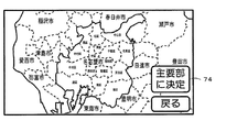
タップ位置が選択アイテムの領域内のときに現在階層より1つ下の階層があるときには、現在階層より1つ下の複数の地区アイテムのうちディスプレイ22の画面上のタップ位置に対応する位置を含む地区アイテムを選択アイテムに設定し(ステップS280)、現在階層より1つ下の階層を現在階層に設定し(ステップS290)、設定した選択アイテムをディスプレイ22の画面中央に表示するために住所選択用地図データを用いて選択時表示制御を実行して(ステップS320)、住所選択用目的地入力処理ルーチンを終了する。例えば、図5の状態で「名古屋市」の領域内でタップ操作が行なわれると「愛知県」に代えて「名古屋市」が地区アイテムに設定されて、「名古屋市」の縮尺データによる縮尺で「名古屋市」が画面中央に表示される。図13に選択アイテムとして「名古屋市」が設定されたときの地図表示の一例を示す。図中「主要部に決定」ボタン74については次に説明する。
When the tap position is within the area of the selected item, if there is a hierarchy one level lower than the current hierarchy, the position corresponding to the tap position on the screen of the
ステップS230でタップ操作がボタン操作であると判定されたときには、図示しない他の制御が実行されて、住所選択用目的地入力処理ルーチンを終了する。他の制御としては、例えば以下の制御がある。図5の状態で「戻る」ボタン72がタップされたときには、前述したように現在階層と選択アイテムとして「国階層」と「日本国」とを設定する処理が行なわれる。また、図13の状態で「主要部に決定」ボタン74がタップされたときには、現在階層の地区アイテムとしての「名古屋市」の予め定められた主要部(例えば市役所の所在地)の座標(緯度,経度)を目的地に設定する処理が行なわれる。さらに、住所選択に際して予め定められた最も下の例えば町階層の選択アイテムが画面中央に表示されているときに図示しない「番地入力」ボタンがタップされたときには、行政区画における選択アイテム内の住所を指定するための丁目や番,号などを入力すると共に入力した住所の座標(緯度,経度)を目的地に設定する処理が行なわれる。
If it is determined in step S230 that the tap operation is a button operation, other control (not shown) is executed, and the address selection destination input processing routine is terminated. Examples of other controls include the following controls. When the “return”
このように、実施例のナビゲーション装置20では、住所選択により目的地を入力する際において、ディスプレイ22に選択アイテムが表示されているときに操作によって地区アイテムが選択されると、その地区アイテムを選択アイテムとしてディスプレイ22の画面中央に表示するから、選択アイテムの地図上の大きさや形状に拘わらずディスプレイ22の画面に対して視認しやすい状態で選択アイテムを表示させることができる。また、こうしてディスプレイ22に選択アイテムが表示されると、再びタッチパネル24の操作によって地区アイテムの選択が可能となるから、ディスプレイ22の画面に対して選択アイテム毎に視認しやすい状態で選択アイテムを次々に表示させることができる。さらに、タッチパネル24のフリック操作の操作速度が速いほど選択アイテムと同一階層の複数の地区アイテムのうちフリック操作の指示方向にある遠方の地区アイテムを選択するから、住所の選択を視覚的に行なう際の操作性を向上させることができる。また、選択アイテムをディスプレイ22の画面中央に表示する制約の範囲内で選択アイテムと同一階層の他の地区を選択地区の周囲に境界や名称と共に表示するから、他の地区の選択を視覚的により容易に行なえるようにすることができる。しかも、タッチパネル24のタップ操作が選択アイテムの領域内で行なわれたときには、タップ操作のタップ位置に対応する選択アイテムより1つ下の階層の地区アイテムを選択するから、住所を絞り込んで選択可能とすることができる。また、選択アイテムの領域内に選択アイテムより1つ下の階層の複数の地区アイテムを境界や名称と共に表示するから、選択アイテムより1つ下の階層の地区アイテムの選択を視覚的により容易に行なえるようにすることができる。そして、タッチパネル24のドラッグ操作によって選択アイテムと同一階層の地区アイテムを選択すると共に、タッチパネル24のタップ操作が選択アイテムの領域外で行なわれたときには、タップ操作のタップ位置に対応する選択アイテムと同一階層の地区アイテムを選択するから、タッチパネル24のフリック操作とドラッグ操作とタップ操作という3種類の操作によって選択アイテムの領域外の選択アイテムと同一階層の他の地区アイテムを選択可能とすることができる。なお、住所選択用の目的地の入力処理に関し、地図画像のスクロールや縮尺変更を行なう図2の住所選択用目的地入力処理ルーチンのステップS160,S190の処理や図4の初期設定時表示制御ルーチンの各処理,図8の選択時表示制御ルーチンの各処理は、電子制御ユニット30の目的地入力処理部64の表示制御部65により実行され、地図画像上の選択アイテムを選択する図2の住所選択用目的地入力処理ルーチンのステップS130,S220,S260,S280の各処理は、電子制御ユニット30の目的地入力処理部64の地区選択部66により実行され、図2の住所選択用目的地入力処理ルーチンの他のステップの各処理は、電子制御ユニット30の目的地入力処理部64の図示しない他の制御部により実行される。
As described above, in the
以上説明した実施例のナビゲーション装置20によれば、階層化された行政区画における選択アイテムがディスプレイ22に表示されているときに、方向指示操作としてタッチパネル24のフリック操作が行なわれたときには、行政区画における選択アイテムと同一階層の複数の地区アイテムのうち選択アイテムに対してフリック操作の指示方向にある地区アイテムを選択し、選択アイテムを内包する最小の矩形の四辺とディスプレイ22の画面の外縁との間に少なくとも所定のマージンαが確保される最大のサイズで選択アイテムがディスプレイ22の画面中央に表示されるようディスプレイ22を制御するから、ディスプレイ22の画面に対して視認しやすい状態で選択アイテムを表示させることができる。また、繰り返し方向指示操作によって地区アイテムの選択が可能となるから、ディスプレイ22の画面に対して選択アイテム毎に視認しやすい状態で選択アイテムを順次表示させることができる。この結果、住所の選択を視覚的により容易に行なえるようにすることができる。
According to the
実施例のナビゲーション装置20では、選択アイテムをディスプレイ22の画面中央に表示する制約の範囲内で選択アイテムと同一階層の各地区アイテムを選択アイテムの周囲に表示するものとしたが、選択アイテムの領域外の各地区アイテムについては表示しないものとしてもよい。この場合でも、タッチパネル24のフリック操作や選択アイテムの領域外でのタップ操作によって選択アイテムと同一階層の選択アイテム以外の地区アイテムを選択可能としても構わない。
In the
実施例のナビゲーション装置20では、タッチパネル24のフリック操作とドラッグ操作と選択アイテムの領域外でのタッチパネル24のタップ操作との3種類の操作によって選択アイテムと同一階層の各地区アイテムを選択可能としたが、タッチパネル24のフリック操作のみでこうした各地区アイテムを選択可能としてもよい。この場合、タッチパネル24のドラッグ操作や選択アイテムの領域外でのタッチパネル24のタップ操作に対しては特に選択処理を実行しないものとしても構わない。
In the
実施例のナビゲーション装置20では、選択アイテムの領域内に選択アイテムより1つ下の階層の複数の地区アイテムを表示するものとしたが、住所選択により目的地を入力する際に選択アイテムの領域内に選択アイテムより1つ下の階層の地区アイテムが存在する場合でも選択アイテムの領域内には地区アイテムを表示しないものとしてもよい。この場合でも、選択アイテムの領域内でのタッチパネル24のタップ操作によって選択アイテムより1つ下の階層の地区アイテムを選択可能としても構わない。
In the
実施例のナビゲーション装置20では、選択アイテムの領域内でタッチパネル24のタップ操作が行われたときにはタップ位置に対応する選択アイテムより1つ下の階層の地区アイテムを選択するものとしたが、例えば住所選択用の地図表示は都道府県階層のみとするなど、選択アイテムの領域内でタッチパネル24のタップ操作が行われたときにはタップ位置に対応する座標(緯度,経度)を直ちに目的地に設定するなどとしてもよい。
In the
実施例のナビゲーション装置20では、選択アイテムや、選択アイテムの領域外の地区アイテム、選択アイテムの領域内の地区アイテムについて境界と名称とを表示するものとしたが、名称については、選択アイテムを含む全ての地区アイテムに対して表示してもよいし、選択アイテム以外に対しては一部のみを表示したり一切表示しないものとしてもよい。
In the
実施例のナビゲーション装置20では、選択アイテムをディスプレイ22の画面中央に表示するために、選択アイテムを内包する最小の矩形の四辺とディスプレイ22の矩形状の画面の対応する四辺との間に少なくとも所定のマージンαが確保される最大のサイズの縮尺として選択アイテム毎に予め定められてHDD40の住所選択用地図データの一部として記憶された縮尺データを用いるものとしたが、選択アイテムを内包する最小の矩形を実際に形成する必要はないし、選択アイテム毎に縮尺データを予め定めて記憶する必要もない。例えば、結果的に同様に所定のマージンαが確保されることになるように、選択アイテムを表示する毎に選択アイテムの形状や大きさとディスプレイ22の画面サイズとの関係を用いて演算処理を行なって選択アイテムをディスプレイ22の画面中央に表示するものとしてもよい。なお、ディスプレイ22の画面は矩形状とは異なる例えば楕円形でも構わない。
In the
実施例のナビゲーション装置20では、ディスプレイ22に表示された地図画像を操作する際にディスプレイ22の画面に取り付けられたタッチパネル24を用いるものとしたが、例えばディスプレイ22のうち画面とは異なる左右一方の端部に取り付けられたりディスプレイ22とは独立に遠隔操作可能なコントローラに取り付けられたジョイスティックなど、ディスプレイ22に表示された地図画像を操作する際に方向指示操作が可能なものであれば如何なるものを用いるものとしてもよい。
In the
実施例では、本発明をナビゲーション装置20に適用して説明したが、ナビゲーション装置20の制御方法の形態としてもよいし、こうしたナビゲーション装置20の制御方法の各ステップを1または複数のコンピュータで実現させるためのプログラムの形態とするものとしてもよい。
In the embodiment, the present invention is applied to the
実施例の主要な要素と課題を解決するための手段の欄に記載した発明の主要な要素との対応関係について説明する。実施例では、住所選択用地図データを含む地図データを記憶するHDD40が「情報記憶手段」に相当し、地図画像を表示可能なディスプレイ22が「表示手段」に相当し、ディスプレイ22の画面に取り付けられたタッチパネル24が「操作手段」に相当し、図8の選択時表示制御ルーチンなどを実行する電子制御ユニット30が「表示制御手段」に相当し、タッチパネル24のフリック操作が行なわれたときに選択アイテムと同一階層の複数の地区アイテムのうちフリック操作の指示方向にある地区アイテムを選択する図2の住所選択用目的地入力処理ルーチンのステップS220の処理などを実行する電子制御ユニット30が「地区選択手段」に相当する。
The correspondence between the main elements of the embodiment and the main elements of the invention described in the column of means for solving the problems will be described. In the embodiment, the
なお、実施例の主要な要素と課題を解決するための手段の欄に記載した発明の主要な要素との対応関係は、実施例が課題を解決するための手段の欄に記載した発明を実施するための形態を具体的に説明するための一例であることから、課題を解決するための手段の欄に記載した発明の要素を限定するものではない。即ち、課題を解決するための手段の欄に記載した発明についての解釈はその欄の記載に基づいて行なわれるべきものであり、実施例は課題を解決するための手段の欄に記載した発明の具体的な一例に過ぎないものである。 The correspondence between the main elements of the embodiment and the main elements of the invention described in the column of means for solving the problem is the same as that of the embodiment described in the column of means for solving the problem. Therefore, the elements of the invention described in the column of means for solving the problems are not limited. That is, the interpretation of the invention described in the column of means for solving the problems should be made based on the description of the column, and the examples are those of the invention described in the column of means for solving the problems. It is only a specific example.
以上、本発明を実施するための形態について実施例を用いて説明したが、本発明はこうした実施例に何等限定されるものではなく、本発明の要旨を逸脱しない範囲内において、種々なる形態で実施し得ることは勿論である。 As mentioned above, although the form for implementing this invention was demonstrated using the Example, this invention is not limited at all to such an Example, In the range which does not deviate from the summary of this invention, it is with various forms. Of course, it can be implemented.
本発明は、ナビゲーション装置の製造産業などに利用可能である。 The present invention can be used in the manufacturing industry of navigation devices.
20 ナビゲーション装置、22 ディスプレイ、24 タッチパネル、26 スピーカ、30 電子制御ユニット、32 CPU、34 ROM、36 RAM、38 フラッシュメモリ、40 ハードディスクドライブ(HDD)、50 GPS受信機、52 方位センサ、60 ロケーション処理部、62 地図表示処理部、64 目的地入力処理部、65 表示制御部、66 地区選択部、68 ナビゲーション処理部、70 「住所」ボタン、72 「戻る」ボタン、74 「目的地に決定」ボタン。 20 navigation device, 22 display, 24 touch panel, 26 speaker, 30 electronic control unit, 32 CPU, 34 ROM, 36 RAM, 38 flash memory, 40 hard disk drive (HDD), 50 GPS receiver, 52 direction sensor, 60 location processing Part, 62 map display processing part, 64 destination input processing part, 65 display control part, 66 district selection part, 68 navigation processing part, 70 “address” button, 72 “return” button, 74 “determine destination” button .
Claims (7)
前記操作手段による操作に基づいて階層化された行政区画における一階層の一地区を選択する地区選択手段と、
前記地区選択手段により選択された一地区である選択地区が表示されるよう前記表示手段を制御する表示制御手段とを備え、
前記地区選択手段は、前記表示手段に前記選択地区が表示されているときに前記操作手段により方向指示操作が行なわれたときには、前記行政区画における前記選択地区と同一階層の複数の地区のうち該選択地区に対して前記方向指示操作の指示方向にある一地区を選択する手段であり、
前記表示制御手段は、選択地区を内包する最小の矩形の四辺と前記表示手段の画面の外縁との間に少なくとも所定のマージンが確保される最大のサイズで前記選択地区が前記表示手段の画面中央に表示されるよう前記表示手段を制御する手段である、
ことを特徴とするナビゲーション装置。 Information storage means for storing map information, display means for displaying a map image using map information stored in the information storage means, and operation means for operating the map image displayed on the display means An in-vehicle navigation device capable of inputting a destination by selecting an address,
District selecting means for selecting one district in one hierarchy in the administrative divisions hierarchized based on the operation by the operating means;
Display control means for controlling the display means so that a selected district that is one district selected by the district selection means is displayed;
When the direction selection operation is performed by the operation means when the selected area is displayed on the display means, the district selecting means is a plurality of districts of the same district as the selected district in the administrative district. A means for selecting one district in the direction indicated by the direction indicating operation with respect to the selected district,
The display control means is configured such that the selected area is at the center of the screen of the display means with a maximum size that ensures at least a predetermined margin between the four sides of the smallest rectangle containing the selected area and the outer edge of the screen of the display means. Means for controlling the display means to be displayed on
A navigation device characterized by that.
前記操作手段は、前記表示手段の画面に取り付けられたタッチパネルであり、
前記地区選択手段は、前記方向指示操作として操作者による前記タッチパネルのフリック操作が行なわれたときには、前記フリック操作の操作速度が速いほど前記行政区画における前記選択地区と同一階層の複数の地区のうち該選択地区に対して前記フリック操作の操作方向とは反対の指示方向にある遠方の一地区を選択する手段である、
ナビゲーション装置。 The navigation device according to claim 1,
The operation means is a touch panel attached to the screen of the display means,
When the flick operation of the touch panel by an operator is performed as the direction instruction operation, the district selection unit is configured to select a district in the same level as the selected district in the administrative district as the operation speed of the flick operation increases. It is a means for selecting a distant area in the indicated direction opposite to the operation direction of the flick operation for the selected area.
Navigation device.
前記表示制御手段は、前記選択地区を前記表示手段の画面中央に表示するという制約の範囲内で前記選択地区外に前記行政区画における該選択地区と同一階層の該選択地区に近接する各地区が少なくとも該各地区間の境界および該選択地区との境界と共に表示されるよう前記表示手段を制御する手段である。
ナビゲーション装置。 The navigation device according to claim 2,
The display control means includes, within the restriction that the selected area is displayed at the center of the display screen, each area adjacent to the selected area in the same level as the selected area outside the selected area. It is means for controlling the display means so that it is displayed together with at least the boundary of each local section and the boundary with the selected area.
Navigation device.
前記地区選択手段は、前記表示手段に表示されている前記選択地区内で操作者により前記タッチパネルのタップ操作が行なわれたときには、前記タップ操作のタップ位置に対応する前記選択地区より1つ下の階層の一地区を選択する手段である、
ナビゲーション装置。 The navigation device according to claim 2 or 3, wherein
The area selecting means is one lower than the selected area corresponding to the tap position of the tap operation when an operator performs a tap operation on the touch panel within the selected area displayed on the display means. A means of selecting a district in the hierarchy,
Navigation device.
前記表示制御手段は、前記選択地区内に前記行政区画における該選択地区より1つ下の階層の複数の地区が少なくとも該複数の地区間の境界および該選択地区との境界と共に表示されるよう前記表示手段を制御する手段である、
ナビゲーション装置。 The navigation device according to claim 4,
The display control means is configured so that a plurality of districts one level below the selected district in the administrative district are displayed in the selected district together with at least a boundary between the plurality of districts and a boundary with the selected district. Means for controlling the display means;
Navigation device.
(a)前記表示手段に前記選択地区が表示されているときに前記操作手段により方向指示操作が行なわれたときには、前記行政区画における前記選択地区と同一階層の複数の地区のうち該選択地区に対して前記方向指示操作の指示方向にある一地区を選択し、
(b)選択地区を内包する最小の矩形の四辺と前記表示手段の画面の外縁との間に少なくとも所定のマージンが確保される最大のサイズで前記選択地区が前記表示手段の画面中央に表示されるよう前記表示手段を制御する、
ことを特徴とするナビゲーション装置の制御方法。 Information storage means for storing map information, display means for displaying a map image using map information stored in the information storage means, and operation means for operating the map image displayed on the display means The destination can be input by selecting the address, and one district in the hierarchical administrative district is selected based on the operation by the operation means, and the selected district that is the selected one district is displayed. A control method for an in-vehicle navigation device for controlling the display means,
(A) When a direction instruction operation is performed by the operation means while the selected area is displayed on the display means, the selected area is selected from a plurality of areas in the same level as the selected area in the administrative district. Select a district in the direction indicated by the direction indication operation
(B) The selected area is displayed in the center of the display means with the maximum size that ensures at least a predetermined margin between the four sides of the smallest rectangle containing the selected area and the outer edge of the display means screen. Controlling the display means to
A control method for a navigation device.
Priority Applications (1)
| Application Number | Priority Date | Filing Date | Title |
|---|---|---|---|
| JP2010279312A JP2012127791A (en) | 2010-12-15 | 2010-12-15 | Navigation device and control method therefor and program |
Applications Claiming Priority (1)
| Application Number | Priority Date | Filing Date | Title |
|---|---|---|---|
| JP2010279312A JP2012127791A (en) | 2010-12-15 | 2010-12-15 | Navigation device and control method therefor and program |
Publications (1)
| Publication Number | Publication Date |
|---|---|
| JP2012127791A true JP2012127791A (en) | 2012-07-05 |
Family
ID=46645003
Family Applications (1)
| Application Number | Title | Priority Date | Filing Date |
|---|---|---|---|
| JP2010279312A Pending JP2012127791A (en) | 2010-12-15 | 2010-12-15 | Navigation device and control method therefor and program |
Country Status (1)
| Country | Link |
|---|---|
| JP (1) | JP2012127791A (en) |
Cited By (5)
| Publication number | Priority date | Publication date | Assignee | Title |
|---|---|---|---|---|
| JP2014048694A (en) * | 2012-08-29 | 2014-03-17 | Canon Inc | Display control device, display control method, program, and storage medium |
| JP2014098953A (en) * | 2012-11-13 | 2014-05-29 | Sharp Corp | Information processing apparatus, creation method of software keyboard, and program |
| WO2014141797A1 (en) * | 2013-03-14 | 2014-09-18 | シャープ株式会社 | Information processing device, display device with touch panel, information processing method, and program |
| JP2015162074A (en) * | 2014-02-27 | 2015-09-07 | 株式会社デンソー | Operation system |
| JP2015204046A (en) * | 2014-04-15 | 2015-11-16 | キヤノン株式会社 | Information processing device that manages objects and control method of the same |
-
2010
- 2010-12-15 JP JP2010279312A patent/JP2012127791A/en active Pending
Cited By (7)
| Publication number | Priority date | Publication date | Assignee | Title |
|---|---|---|---|---|
| JP2014048694A (en) * | 2012-08-29 | 2014-03-17 | Canon Inc | Display control device, display control method, program, and storage medium |
| JP2014098953A (en) * | 2012-11-13 | 2014-05-29 | Sharp Corp | Information processing apparatus, creation method of software keyboard, and program |
| WO2014141797A1 (en) * | 2013-03-14 | 2014-09-18 | シャープ株式会社 | Information processing device, display device with touch panel, information processing method, and program |
| JP2014178887A (en) * | 2013-03-14 | 2014-09-25 | Sharp Corp | Information processor, display unit with touch panel, and information processing method and program |
| US9582094B2 (en) | 2013-03-14 | 2017-02-28 | Sharp Kabushiki Kaisha | Information processing device, display device with touch panel, information processing method, and program |
| JP2015162074A (en) * | 2014-02-27 | 2015-09-07 | 株式会社デンソー | Operation system |
| JP2015204046A (en) * | 2014-04-15 | 2015-11-16 | キヤノン株式会社 | Information processing device that manages objects and control method of the same |
Similar Documents
| Publication | Publication Date | Title |
|---|---|---|
| KR100948773B1 (en) | Circumference search method for setting path and navigation system | |
| JP4548460B2 (en) | Navigation device | |
| EP2366973A2 (en) | Map display apparatus, map display method and program | |
| JP2007132676A (en) | Navigation device | |
| JP2002340588A (en) | Navigation system and poi-icon display method | |
| JP2006522317A (en) | Navigation device with touch screen. | |
| JP2012068252A (en) | Navigation apparatus with touch screen | |
| JP2012068133A (en) | Map image display device, map image display method and computer program | |
| JP5421015B2 (en) | Map display device | |
| JP2012127791A (en) | Navigation device and control method therefor and program | |
| JP2007128329A (en) | Map display device and facility display method | |
| JP5328280B2 (en) | Navigation device | |
| JP5605186B2 (en) | Control device, control method of control device, and computer program | |
| JP2010256347A (en) | Navigation system | |
| JP2009134105A (en) | Display device, display control method, display control program and recording medium | |
| JP2001091283A (en) | Bypass route search method of navigation device | |
| JP2012133245A (en) | Map display device, map display method, and computer program | |
| JP2012113096A (en) | Map display device, map display method and computer program | |
| JP3893325B2 (en) | Input display device and input display method | |
| JP5003209B2 (en) | Navigation device | |
| JP4248964B2 (en) | Navigation device, facility list display method and program | |
| JP2009288119A (en) | Navigation system | |
| JP2012189780A (en) | Map display system, map display device, map display method and computer program | |
| JP4937045B2 (en) | Navigation device and map information generation method thereof | |
| JP4835494B2 (en) | Map display device |