JP2005292024A - Map information providing system - Google Patents
Map information providing system Download PDFInfo
- Publication number
- JP2005292024A JP2005292024A JP2004109860A JP2004109860A JP2005292024A JP 2005292024 A JP2005292024 A JP 2005292024A JP 2004109860 A JP2004109860 A JP 2004109860A JP 2004109860 A JP2004109860 A JP 2004109860A JP 2005292024 A JP2005292024 A JP 2005292024A
- Authority
- JP
- Japan
- Prior art keywords
- map information
- navigation device
- vehicle
- identification code
- information
- Prior art date
- Legal status (The legal status is an assumption and is not a legal conclusion. Google has not performed a legal analysis and makes no representation as to the accuracy of the status listed.)
- Pending
Links
Images

Landscapes
- Instructional Devices (AREA)
- Navigation (AREA)
- Traffic Control Systems (AREA)
Abstract
Description
本発明は、車両用または歩行者用ナビゲーション装置に地図情報を配信する地図情報提供システムに関する。 The present invention relates to a map information providing system for distributing map information to a vehicle or pedestrian navigation device.
自動車等の車両内に設置し、現在位置を表示し、目的地までの経路を表示するナビゲーションシステムが知られている。車両の走行に伴ってGPS(Global Positioning System:全地球測位システム)等により現在位置を検出し、その現在位置を表示装置上に道路地図と共に表示して、現在地から目的地までの適切な経路を設定し、表示装置や音声出力装置などによって案内する車両用ナビゲーション装置は、運転者の効率的で安全な運転に貢献している。この装置によって、道に迷うことが少なくなり、快適な運転をすることができる。 A navigation system that is installed in a vehicle such as an automobile, displays a current position, and displays a route to a destination is known. As the vehicle travels, the current position is detected by GPS (Global Positioning System), etc., and the current position is displayed on the display device together with the road map, and an appropriate route from the current position to the destination is displayed. A vehicle navigation device that is set and guided by a display device, an audio output device, or the like contributes to efficient and safe driving for the driver. With this device, it is less likely to get lost and it is possible to drive comfortably.
一方、地図情報を情報センタから車両へ配信するシステムも考案されている。これによれば、最新の地図情報をユーザは得ることができるとともに、さらに天気や交通渋滞、周辺の店舗情報なども得ることができる。 On the other hand, a system for distributing map information from an information center to a vehicle has been devised. According to this, the user can obtain the latest map information, and also obtain weather, traffic jams, nearby store information, and the like.
そして情報センタから得た情報を、車種により選別しナビゲーションシステムに表示するシステムも開示されている(特許文献1)。 A system is also disclosed in which information obtained from an information center is selected by vehicle type and displayed on a navigation system (Patent Document 1).
しかしながら、この方法は、車側でその情報を選別するため、通信量が増加するし、通信時間も増加してしまう。またセンタ側で情報を抽出する考案も開示されているが、また、車両側(情報処理装置)で個別車両情報を保持しており、毎回この個別情報をセンタ側に送信する必要が発生する。このためセンタから情報を受信するたびに車種情報をセンタに送信するため、やはり通信の無駄が生じる。 However, since this method selects the information on the vehicle side, the amount of communication increases and the communication time also increases. Moreover, although the idea which extracts information on the center side is also disclosed, individual vehicle information is held on the vehicle side (information processing apparatus), and it becomes necessary to transmit this individual information to the center side every time. For this reason, every time information is received from the center, the vehicle type information is transmitted to the center, so that communication is wasted.
そこで本発明の課題は、車両ナビゲーション装置または歩行者用ナビゲーション装置に対して、ユーザに必要な地図情報の通信量を低減し、迅速に提供する地図情報提供システムを提供することである。 SUMMARY OF THE INVENTION An object of the present invention is to provide a map information providing system that reduces the amount of map information necessary for a user and provides it quickly to a vehicle navigation device or a pedestrian navigation device.
上記課題を解決するための本発明の地図情報提供手段は、
車両に設置され、または歩行者の携帯する、地図情報と車両または歩行者の現在位置データとに基づき目的地への経路を案内するナビゲーション装置と、
ナビゲーション装置に対し、地図情報を配信する地図情報配信手段と、
を含む地図情報提供システムにおいて、
ナビゲーション装置は、各々に固有の識別コードを有する識別コード記憶手段と、
地図情報配信手段に地図情報の送信を要求する送信部と、
地図情報配信手段からの地図情報を受信する受信部と、
地図情報配信手段から受信した地図情報を表示する表示部とを有し、
地図情報配信手段は、
識別コードとその識別コードを有するナビゲーション装置の使用形態に基づく種別とを記憶するユーザ情報記憶手段と、
種別ごとの地図情報を記憶する地図情報記憶手段と、
ナビゲーション装置からの地図情報の配信要求と識別コードとを受信する受信手段と、
識別コードに基づいて判断されるナビゲーション装置の種別に対応する地図情報をナビゲーション装置へ配信する送信手段と、
を有する。
The map information providing means of the present invention for solving the above problems is as follows.
A navigation device that is installed in a vehicle or carried by a pedestrian and guides a route to a destination based on map information and current position data of the vehicle or pedestrian;
Map information distribution means for distributing map information to the navigation device;
In the map information providing system including
The navigation device includes an identification code storage means having a unique identification code,
A transmission unit that requests the map information distribution means to transmit map information;
A receiving unit for receiving map information from the map information distribution means;
A display unit for displaying the map information received from the map information distribution means,
Map information distribution means
User information storage means for storing an identification code and a type based on a usage pattern of the navigation device having the identification code;
Map information storage means for storing map information for each type;
Receiving means for receiving a map information delivery request and an identification code from the navigation device;
Transmitting means for delivering map information corresponding to the type of the navigation device determined based on the identification code to the navigation device;
Have
ナビゲーション装置は、識別コード記憶手段によって各々に固有の識別コードを有することから、各々のナビゲーション装置を識別することができる。送信部によって地図情報配信手段へ地図情報の配信を識別コードを伴って要求し、受信部によって地図情報配信手段からの地図情報を受信することができる。そして受信した地図情報を表示部によって表示することができる。 Since each navigation apparatus has a unique identification code by the identification code storage means, each navigation apparatus can be identified. The transmission unit can request the map information distribution unit to distribute the map information with an identification code, and the reception unit can receive the map information from the map information distribution unit. The received map information can be displayed on the display unit.
地図情報配信手段は、ユーザ情報記憶手段を有し、これにより各々のナビゲーション装置の識別コードとその識別コードを有するナビゲーション装置の使用形態に基づく種別とを記憶することができる。そしてナビゲーション装置からの要求を受信手段によって受信し、受信した識別コードからそのナビゲーション装置の使用形態に基づく種別を判断し、地図情報記憶手段に記憶されたナビゲーション装置の使用形態に基づく種別ごとの地図情報を選択して、送信手段によって送信することができる。ここでナビゲーション装置の使用形態に基づく種別とは、例えば、大型車、中型車、小型車などを意味する。なお歩行者用ナビゲーションの場合には、歩行者であることが種別である。受信した識別コードにより、地図情報の配信要求をした車両、または歩行者についての情報を得ることができ、これによって地図情報配信手段は、それぞれの車両または歩行者に適切な地図情報を配信することができる。 The map information distribution means has user information storage means, which can store the identification code of each navigation device and the type based on the usage form of the navigation device having the identification code. Then, the request from the navigation device is received by the receiving means, the type based on the usage type of the navigation device is determined from the received identification code, and the map for each type based on the usage type of the navigation device stored in the map information storage means Information can be selected and transmitted by the transmission means. Here, the type based on the usage form of the navigation device means, for example, a large vehicle, a medium vehicle, a small vehicle, or the like. In the case of pedestrian navigation, the type is pedestrian. Information about the vehicle or pedestrian who requested the distribution of map information can be obtained from the received identification code, whereby the map information distribution means distributes appropriate map information to each vehicle or pedestrian. Can do.
本発明の地図情報提供システムのナビゲーション装置は、ナビゲーション装置を有する車両または歩行者が通行した軌跡を識別コードとともに地図情報配信手段に送信し、
地図情報記憶手段は、ナビゲーション装置から受信した軌跡と識別コードとに基づいて、軌跡の種別通行履歴を記憶する。
The navigation device of the map information providing system of the present invention transmits a trajectory traveled by a vehicle or a pedestrian having the navigation device together with an identification code to the map information distribution means,
The map information storage means stores a trajectory type traffic history based on the trajectory and the identification code received from the navigation device.
ナビゲーション装置が、車両または歩行者が通行した軌跡を識別コードとともに地図情報配信手段に送信することにより、地図情報配信手段は、各々のナビゲーション装置の識別コードとその識別コードを有するナビゲーション装置の使用形態に基づく種別とを記憶しているため、この情報によって軌跡の種別通行履歴を記憶することができる。軌跡の種別通行履歴を蓄積することにより、種別ごとの地図情報をデータベース化することができる。 The navigation device transmits the trajectory that the vehicle or the pedestrian has passed to the map information distribution unit together with the identification code, so that the map information distribution unit uses the identification code of each navigation device and the usage form of the navigation device having the identification code. Since the type based on is stored, this type of information can store the trajectory type history. By accumulating the trajectory type traffic history, map information for each type can be stored in a database.
そして本発明の地図情報配信手段は、過去の種別通行履歴に基づいて、ナビゲーション装置の使用形態に基づく種別としての推奨軌跡を含む地図情報を送信する。過去の種別通行履歴を蓄積することによって、地図情報の配信を要求に対し、最もよく通行された軌跡を推奨ルートとして、情報提供することができる。具体的には、例えば、大型車の場合、細い道は通行できないため、幹線道路などを通行した履歴が蓄積されることになる。そこで最も通行履歴の多い道路を推奨道路として、地図情報上に表示されるようにすれば、適切な経路で目的地まで行くことができる。 And the map information delivery means of this invention transmits the map information containing the recommended locus | trajectory as a classification based on the usage type of a navigation apparatus based on the past classification traffic history. By accumulating past type traffic histories, it is possible to provide information on the most frequently trajectory as a recommended route in response to a request for distribution of map information. Specifically, for example, in the case of a large vehicle, since a thin road cannot pass, a history of passing a main road or the like is accumulated. Therefore, if the road with the most travel history is displayed as the recommended road on the map information, the destination can be reached by an appropriate route.
さらに本発明の地図情報提供システムは、
ナビゲーション装置の使用形態に基づく種別として、そのナビゲーション装置が搭載される車両の車体サイズに対応する複数の種別が記憶され、
地図情報記憶手段は、その車体サイズに対応する複数の種別ごとに、各々のナビゲーション装置から送信される通行実績のデータを地図情報記憶手段に蓄積し、
地図情報記憶手段は、地図情報の配信要求先の、車体サイズに基づいて分類される種別に対応する種別地図情報を配信要求先に配信する。
Furthermore, the map information providing system of the present invention provides:
As a type based on the usage form of the navigation device, a plurality of types corresponding to the vehicle body size of the vehicle on which the navigation device is mounted are stored,
The map information storage means accumulates in the map information storage means the traffic performance data transmitted from each navigation device for each of a plurality of types corresponding to the vehicle body size,
The map information storage means distributes the type map information corresponding to the type classified based on the vehicle body size of the map information distribution request destination to the distribution request destination.
ユーザ情報記憶手段に記憶された種別に関する情報として、大型車、中型車、小型車など、どの大きさに分類されるかという情報などの他に、車両のサイズの情報を含む。つまり種別とは、ナビゲーション装置を設置した車両の大きさ、寸法などの情報も含む。またハイブリッド、燃料電池車などの情報を含んでもよい。そして各々のナビゲーション装置から送信される通行実績のデータを地図情報記憶手段に蓄積することで、それぞれの種別に適する種別地図情報を作成することができ、各ナビゲーション装置に、そのナビゲーション装置が設置されている車両にとって適切な地図情報を提供することができる。 The information related to the type stored in the user information storage means includes information on the size of the vehicle, in addition to information on which size is classified, such as a large vehicle, a medium-sized vehicle, and a small vehicle. That is, the type includes information such as the size and dimensions of the vehicle on which the navigation device is installed. Information such as a hybrid and a fuel cell vehicle may also be included. Then, by accumulating in the map information storage means the traffic performance data transmitted from each navigation device, it is possible to create type map information suitable for each type, and the navigation device is installed in each navigation device. It is possible to provide map information appropriate for the vehicle in which the vehicle is located.
さらに種別には、歩行者に携帯されるナビゲーション装置としての種別が加えられる。歩行者の携帯するナビゲーション装置にも、歩行者用の適切な地図情報を送ることができる。歩行者用ナビに対しては、歩行者専用道路などの情報を送信する。 Furthermore, the type as a navigation device carried by a pedestrian is added to the type. Appropriate map information for pedestrians can also be sent to the navigation device carried by the pedestrian. Information such as a pedestrian road is transmitted to the pedestrian navigation.
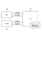
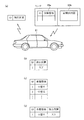
以下、本発明の実施の形態を、図面に示す実施例を参照しながら説明する。図1に本発明の全体構造を示す。本地図情報提供システムは、車両に搭載されたナビゲーション装置(車載ナビ)100と、携帯電話などの歩行者ナビゲーション(歩行者ナビ)101、および地図情報配信手段であるセンタ(地図配信センタ)14からなる。地図配信センタ14は、配信対象となるすべてのユーザの使用形態に基づく種別の情報を保持している。ユーザの種別とは、そのナビゲーション装置が設置されている車両の車種情報(大型車、中型車、小型車、ハイブリッド、燃料電池車や車両寸法など)である。センタ14側ではリアルタイムに車載ナビおよび歩行者ナビより現在の位置情報などを受信する。センタ14側では受信した情報に車種情報を付加し、地図情報データベースとして格納する。
Hereinafter, embodiments of the present invention will be described with reference to examples shown in the drawings. FIG. 1 shows the overall structure of the present invention. The map information providing system includes a navigation device (in-vehicle navigation) 100 mounted on a vehicle, a pedestrian navigation (pedestrian navigation) 101 such as a mobile phone, and a center (map distribution center) 14 that is a map information distribution means. Become. The
地図配信センタ14は、ユーザ端末(車載ナビ100、歩行者ナビ101)からの要求に応じて、このユーザ端末に地図を配信する。また、地図情報センタ14は、地図だけでなく、例えば店舗や施設等の地点情報も備えるようにして、ユーザ端末からの要求に応じて、地図情報を提供すると共に、例えば店舗や施設等の所在地や、その店舗や施設等に関する情報もユーザ端末に配信するようにしてもよい。
The
そして地図配信センタ14は、ナビゲーション端末(車載ナビ100、歩行者ナビ101)から経路探索要求を受け取ると、車種情報が付加された地図情報データベースを用いて、指定された出発地と目的地の2地点間を結ぶ推奨経路を探索し、要求したナビゲーション端末に、その車種に適応した地図情報、推奨経路情報を送信する。
When the
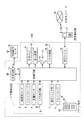
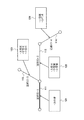
図2は本発明の一実施例としての車両用ナビゲーション装置の全体構成を示すブロック図である。本ナビゲーション装置100は、位置検出器1、操作スイッチ群7、リモートコントロール(以下リモコンと称する)センサ11、音声案内などを行うスピーカ15、外部メモリ9、表示装置10、通信ユニット19、ETC車載器16、これらの接続された制御回路8、リモコン端末12を備えている。
FIG. 2 is a block diagram showing the overall configuration of the vehicle navigation apparatus as one embodiment of the present invention. The
位置検出器1は、周知の地磁気センサ2、ジャイロスコープ3、距離センサ4、および衛星からの電波に基づいて車両の位置を検出するGPSのためのGPS受信機5を有している。これらのセンサ等2,3,4,5は各々が性質の異なる誤差を持っているため、複数のセンサにより各々補完しながら使用するように構成されている。なお、精度によっては前述したうちの一部センサで構成してもよく、さらに、ステアリングの回転センサや各転動輪の車輪センサ等を用いてもよい。
The
操作スイッチ群7は、例えば表示装置10と一体になったタッチスイッチもしくはメカニカルなスイッチ等が用いられる。タッチスイッチは、表示装置10の画面上に縦横に微細に配置された赤外線センサより構成されており、例えば指やタッチペンなどでその赤外線を遮断すると、その遮断した位置が2次元座標値(X,Y)として検出される。これら操作スイッチ群7およびリモコン端末12によって、種々の指示を入力することが可能である。
As the
表示部としての表示装置10はカラー液晶表示器により構成されており、表示装置10の画面には位置検出器1から入力された車両現在位置マークと、地図配信センタ14から受信した地図情報、更に地図上に表示する誘導経路等付加データとを重ね合わせて表示すると共に、本画面に経路案内の設定および経路誘導中の案内や画面の切り換え操作を行うためのボタンが表示される。
The
送信部、受信部としての送受信機13は、地図配信センタ14から提供される情報を受信し、また地図配信センタ14へ情報を送信するための装置である。この送受信機13を介して外部から受け取った情報は、制御回路8において処理する。
The transmitter /
また、本車両用ナビゲーション装置100は、通信ユニット19を介して、携帯電話機17など移動体通信機器により、外部ネットワーク18との接続が可能で、インターネットに接続したり、専用の情報センターに接続することができる。さらに、ETC(自動料金収受システム,ETC:Electronic Toll Collection)車載器16と通信することにより、ETC車載器16がETC路上器から受信した、料金情報などをナビゲーション装置に取り込むことができる。また、ETC車載器16によって外部ネットワーク18と接続することも可能である。
The
さらに、外部メモリ9には、本ナビゲーション装置の動作に必要なデータが記憶される。なお、外部メモリ9は、車両のイグニッションスイッチがオフ状態になっても(即ち、ナビゲーション装置100がオフ状態)、記憶内容が保持される。
Further, the external memory 9 stores data necessary for the operation of the navigation device. Note that the external memory 9 retains the stored contents even when the ignition switch of the vehicle is turned off (that is, the
制御回路8は通常のコンピュータとして構成されており、図3のように周知のCPU81,ROM82,RAM83,I/O84およびこれらの構成を接続するバスライン85が備えられている。
The control circuit 8 is configured as a normal computer, and includes a well-known
CPU81は、ROM82およびRAM83に記憶されたプログラムおよびデータにより制御を行う。図3のように、ROM82にはオペレーティングシステム(以下、OSと称する)82sとOS82s上で動作するナビゲーションプログラム(以下、ナビプログラムと称する)82p、識別コード82kが格納される。識別コード82kは、各ナビゲーション装置に固有のコードであり、ROM82が識別コード記憶手段である。また、ナビプログラム82pは、OS82s上にてナビプログラム用ワークメモリ83wを作業領域とする形で作動する。さらに、RAM83には、OS82sのワークメモリ83sが形成される。
The
このような構成を持つことにより、本ナビゲーション装置100は、制御回路8のCPU81によりナビプログラム82pが起動されると、運転者が操作スイッチ群7あるいはリモコン端末12を操作して、表示装置10上に表示されるメニューから目的地経路を表示装置10に表示させるための経路案内処理を選択した場合、次のような処理を実施する。即ち、運転者が目的地を入力すると、GPS受信機5から得られる衛星のデータに基づき車両の現在地が求められ、その情報や識別コードとともに地図配信センタ14に地図情報の配信要求を送信する。そして地図配信センタ14から地図情報を受信し、表示装置10上にその車種の車両が通行するために適する道路地図を表示し、運転者に適切な経路を案内する。上記の動作および以下の実施例は、ナビプログラム82pにより制御されている。
With this configuration, when the navigation program 82p is activated by the
図4は地図配信センタ14の情報サーバ25の一実施例の構成を示す図である。情報サーバ25は、CPU51,ROM52,RAM53および入出力インターフェース(I/O)54を有し、これらがバスライン55により送受信可能に接続されたコンピュータ本体50を備え、これに周辺機器として、キーボード56あるいはマウス57等の入力装置、CD−ROMドライブ58あるいはフロッピー(登録商標)ディスクドライブ(以下、FDDと記す)59等の記録媒体読取手段、HDD(ハードディスクドライブ)60,モニタ制御部61を介して接続されるモニタ62、プリンタ63、および送受信装置22等との通信を行なうネットワーク制御部64等が接続されたコンピュータシステムとして全体が構築されている。CD−ROMドライブ58の代わりにDVD−ROMドライブ等を用いてもよい。
FIG. 4 is a diagram showing a configuration of an embodiment of the
HDD60には、オペレーティングシステムプログラム(以下、OSという)60a及び情報サーバプログラム60bが格納されている。情報サーバプログラム60bは、情報サーバとしての機能を実現するため、OS60a上でRAM53に確保される情報サーバワークメモリ53bを作業領域とする形で作動するものである。これは、例えばCD−ROM65等にコンピュータ読み取り可能な状態で記憶され、HDD60上の所定の記憶領域にインストールされるものである。また、RAM53には、OS60aのワークメモリ53aも形成される。
The
また、HDD60には、ユーザ情報データベース23a、地図情報データベース23bが構築されている。したがってHDD60がユーザ情報記憶手段、地図情報記憶手段である。ユーザ情報データベース23aは、図6のようなユーザのナビゲーション装置に割り当てられた識別コードと、その識別コードのナビゲーション装置が設置されている車両の車種情報が記録されている。車種情報とは、そのナビゲーション装置が設置されている車両が、大型車、中型車、小型車であるか、または、車両の寸法などである。或いは、ハイブリッド車、燃料電池車などの情報も含んでもよい。歩行者用ナビゲーションの場合は、車種の代わりに歩行者であることが記録されている。また、地図情報データベース23bには、地図データが記録されている。地図データとしての道路には、それぞれの道路に道路IDが定義されている。そして、定義された道路毎に車種別の通行履歴が記録される。そしてユーザの走行履歴により、車種別の地図情報データベースとして記録されている。
In addition, a
このような構成を持つことにより、本情報サーバ25は、コンピュータ本体50のCPU51により情報サーバプログラム60bが起動されると、必要な初期化処理を実行した後に情報サーバとして機能する。この後、送受信装置22を経由してナビゲーション装置100からの接続要求あるいは検索要求が発生した場合、情報サーバプログラム60bに格納されている処理が実行され、必要なデータあるいはデータベース23の検索結果を送受信装置22を経由してナビゲーション装置100へ送る。
With this configuration, the
また、ユーザ情報データベース23aや地図情報データベース23bの内容は随時更新される。これは走行中の車両から車両情報、現在地が送られてきた場合に、データベース23bの車両通行履歴を更新するものである。
The contents of the
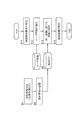
図5に地図情報配信システムの処理ステップの実施例を示す。ユーザの有するナビゲーション装置には、各々に識別コード(ID)が割り振られている。そしてサーバには、各識別コードのナビゲーション装置が設置されている車両についての車種情報がユーザ情報として記録されている。 FIG. 5 shows an example of processing steps of the map information distribution system. An identification code (ID) is assigned to each navigation device of the user. In the server, vehicle type information about a vehicle in which a navigation device for each identification code is installed is recorded as user information.
まず、車種別の走行情報を記録した地図データベースの作成ついて説明する。ユーザの車両は、走行中、位置検出器1により現在位置を検出し、地図配信センタ14へ、現在位置の情報または通行中の道路IDを、識別コードとともに送信する(S1)。現在位置の情報または通行中の道路IDの双方を送信するようにしてもよいし、どちらかでもよい。地図配信センタ14はその情報を受信し(S2)、地図データベース23bに、車種別の走行路の情報を蓄積する(S3)。具体的には、識別コードとともに現在位置の情報または通行中の道路IDを受信した地図配信センタ14は、識別コードから、予め記憶されているその識別コードの車種情報を付加し、どの車種の車両がどの道路を走行したかを地図情報データベースに記録していく。これにより大型車の通る道、小型車の通る道、また歩行者の通る道が分類されていく。数多くのユーザの走行情報をデータベース化することにより、それぞれの車種に最適な道、或いは走行不可な道を分類することができる。
First, the creation of a map database that records vehicle-specific travel information will be described. While traveling, the user's vehicle detects the current position by the
続いて、ユーザは、地図情報取得の要求として、識別コード(ID)を、地図配信センタ14に送信する(S11)。ユーザの要求を受け取ったサーバは、受信した識別コードの車種をユーザ情報データベースから調べる。そしてS13で、同一車種に関する情報をS3で作成された地図データベースから抽出する。そしてユーザの車種に適した地図情報を配信する(S14)。
Subsequently, the user transmits an identification code (ID) to the
図6にナビゲーション装置と地図配信センタのデータの一例を示す。(a)に示すように車両91からは識別コード(ID)と現在位置との情報を地図配信センタに送信する。地図配信センタ14には、IDごとの車種情報と、地図データが記録されている。そして前述の順序でユーザ情報と地図データとをリンクさせる。(b)には、ユーザのナビゲーション装置100が発信するデータの例を示す。このデータには、ユーザのIDと現在位置の情報が含まれる。そしてセンタ14の有するユーザ情報としての車種情報の例を(c)に示す。センタには全ユーザのIDとその車種情報が蓄積されている。そして(d)に示すように、ユーザのナビゲーション装置100から送信されたIDに基づき、ユーザの送信情報と情報サーバに記憶されたユーザ情報とを、リンクする。このデータを用いてそれぞれの道路の走行車両の履歴を車種別に記録する。
FIG. 6 shows an example of data of the navigation device and the map distribution center. As shown in (a), the
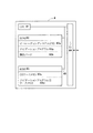
図7に地図配信サーバ内の車種情報を加えた地図情報の実施例を示す。まず図7に示すように、道路111は、道路IDが1、道路112は、道路IDが2、道路113は、道路IDが3、道路114は、道路IDが4として記憶されている。このように全ての道路に道路IDが割り振られている。ユーザのナビゲーション装置から走行情報が送信されると、それぞれの道路IDと走行した車種とがリンクされて記憶される。例えば、道路ID1の道路は、歩行者のみが通行していれば、その旨記録121される。そして歩行者用ナビゲーション装置から地図情報の提供要求があれば、歩行者用の道路として送信する。また道路ID2、3の道路は、大型車、中型車、小型車が走行した履歴が記録122,123されている。したがって、これらの車種のナビゲーション装置から、地図配信要求があれば、これらの道路情報を送信する。さらに道路ID4の道路114は、小型車と歩行者の通行履歴の記録124があるため、小型車、歩行者用の道路と判断される。
FIG. 7 shows an example of map information to which vehicle type information in the map distribution server is added. First, as shown in FIG. 7, the
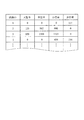
図8に道路別の車種別通行履歴データの例を示す。図7で述べたように、道路の道路ID別に、車種ごとの通行履歴をデータベース化する。これは、地図配信センタ14の情報サーバ25に記録されている。図8には、各道路IDごとに、大型車、中型車、小型車、歩行者のそれぞれの通行回数が記録されている。道路ID1の道路は、歩行者の通行のみが記録されている。すなわち歩行者のみが通ることのできる道路である。道路ID2,3は、大型車、中型車、小型車の走行履歴が記録されている。すなわち大型車、中型車、小型車の走行することのできる道路である。さらに道路ID4の道路は、小型車、歩行者の通行が記録され、小型車または歩行者の通行できる道路と判断される。
FIG. 8 shows an example of vehicle-specific traffic history data by road. As described in FIG. 7, the traffic history for each vehicle type is made into a database for each road ID. This is recorded in the
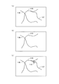
図9にナビゲーション装置の画面を示す。(a)は、小型車の画面、(b)、(c)は、大型車の画面の実施例である。小型車では、細い道も通行できるため、道路115,116,117が表示されている。ところが大型車の場合、細い道路117は通行できない。そのような情報が地図データベースに車種別通行記録として蓄積されているため、(b)に示すように、大型車のナビゲーション装置の画面には、細く大型車の通行できない道路(通った履歴がない道)117は表示されない。或いは、(c)に示すように、細くて大型車の通ることのできない道117には、印118を付けて示すこともできる。
FIG. 9 shows a screen of the navigation device. (A) is an example of a small car screen, and (b) and (c) are examples of a large car screen. Since small cars can also pass through narrow roads,
以上のように、車両用ナビゲーション装置または歩行者用ナビゲーション装置から、通行道路の情報を受信し、種別通行履歴として地図配信センタに蓄積することにより、車種または歩行者に応じた地図情報を配信することができる。 As described above, road information is received from the vehicle navigation device or the pedestrian navigation device, and the map information corresponding to the vehicle type or pedestrian is distributed by storing it in the map distribution center as a type traffic history. be able to.
13 送受信機
14 地図配信センタ
22 送受信機
25 情報サーバ
91 車両
100 ナビゲーション装置
13
Claims (5)
前記ナビゲーション装置に対し、前記地図情報を配信する地図情報配信手段と、
を含む地図情報提供システムにおいて、
前記ナビゲーション装置は、各々に固有の識別コードを有する識別コード記憶手段と、
前記地図情報配信手段に前記地図情報の送信を要求する送信部と、
前記地図情報配信手段からの前記地図情報を受信する受信部と、
前記地図情報配信手段から受信した前記地図情報を表示する表示部とを有し、
前記地図情報配信手段は、
前記識別コードとその識別コードを有する前記ナビゲーション装置の使用形態に基づく種別とを記憶するユーザ情報記憶手段と、
前記種別ごとの地図情報を記憶する地図情報記憶手段と、
前記ナビゲーション装置からの前記地図情報の配信要求と前記識別コードとを受信する受信手段と、
前記識別コードに基づいて判断される前記ナビゲーション装置の種別に対応する前記地図情報を前記ナビゲーション装置へ配信する送信手段と、
を有する地図情報提供システム。 A navigation device that is installed in a vehicle or carried by a pedestrian and that guides a route to a destination based on map information and current position data of the vehicle or pedestrian;
Map information distribution means for distributing the map information to the navigation device;
In the map information providing system including
The navigation device includes an identification code storage means having a unique identification code,
A transmission unit that requests the map information distribution means to transmit the map information;
A receiver for receiving the map information from the map information distribution means;
A display unit for displaying the map information received from the map information distribution means;
The map information distribution means includes:
User information storage means for storing the identification code and a type based on a usage pattern of the navigation device having the identification code;
Map information storage means for storing map information for each type;
Receiving means for receiving the map information delivery request and the identification code from the navigation device;
Transmitting means for delivering the map information corresponding to the type of the navigation device determined based on the identification code to the navigation device;
A map information providing system.
前記地図情報記憶手段は、前記ナビゲーション装置から受信した前記軌跡と前記識別コードとに基づいて、前記軌跡の種別通行履歴を記憶する請求項1に記載の地図情報提供システム。 The navigation device transmits a trajectory traveled by the vehicle or the pedestrian having the navigation device together with the identification code to the map information distribution means,
2. The map information providing system according to claim 1, wherein the map information storage unit stores a type traffic history of the trajectory based on the trajectory received from the navigation device and the identification code.
前記地図情報記憶手段は、その車体サイズに対応する複数の種別ごとに、各々のナビゲーション装置から送信される通行実績のデータを前記地図情報記憶手段に蓄積し、
前記地図情報記憶手段は、前記地図情報の配信要求先の、前記車体サイズに基づいて分類される種別に対応する種別地図情報を配信要求先に配信する請求項1ないし3のいずれか1項に記載の地図情報提供システム。 As the type based on the usage form of the navigation device, a plurality of types corresponding to the vehicle body size of the vehicle on which the navigation device is mounted are stored,
The map information storage means stores, in the map information storage means, data of traffic records transmitted from each navigation device for each of a plurality of types corresponding to the vehicle body size,
The said map information storage means delivers the classification map information corresponding to the classification classified based on the said vehicle body size of the distribution request destination of the said map information to a distribution request destination. The map information provision system described.
The map information providing system according to claim 4, wherein a classification as a navigation device carried by a pedestrian is further added to the classification.
Priority Applications (1)
| Application Number | Priority Date | Filing Date | Title |
|---|---|---|---|
| JP2004109860A JP2005292024A (en) | 2004-04-02 | 2004-04-02 | Map information providing system |
Applications Claiming Priority (1)
| Application Number | Priority Date | Filing Date | Title |
|---|---|---|---|
| JP2004109860A JP2005292024A (en) | 2004-04-02 | 2004-04-02 | Map information providing system |
Publications (1)
| Publication Number | Publication Date |
|---|---|
| JP2005292024A true JP2005292024A (en) | 2005-10-20 |
Family
ID=35325104
Family Applications (1)
| Application Number | Title | Priority Date | Filing Date |
|---|---|---|---|
| JP2004109860A Pending JP2005292024A (en) | 2004-04-02 | 2004-04-02 | Map information providing system |
Country Status (1)
| Country | Link |
|---|---|
| JP (1) | JP2005292024A (en) |
Cited By (11)
| Publication number | Priority date | Publication date | Assignee | Title |
|---|---|---|---|---|
| JP2009181469A (en) * | 2008-01-31 | 2009-08-13 | Pioneer Electronic Corp | Mobile terminal, information management server, information control method, information management method, information collection program, information management program and recording medium |
| JP2010217765A (en) * | 2009-03-18 | 2010-09-30 | Ntt Docomo Inc | System and method for creating map data |
| JP2011154536A (en) * | 2010-01-27 | 2011-08-11 | Fujitsu Ten Ltd | Information providing system and in-vehicle device |
| JP2012515325A (en) * | 2009-01-14 | 2012-07-05 | トムトム インターナショナル ベスローテン フエンノートシャップ | Improvements for vehicle-mounted navigation devices |
| JP2013050405A (en) * | 2011-08-31 | 2013-03-14 | Mic Ware:Kk | Navigation device, navigation method and program |
| US8700293B2 (en) | 2007-01-26 | 2014-04-15 | Xanavi Informatics Corporation | Traffic information distribution method, traffic information distribution apparatus and in-vehicle terminal |
| JP2015014610A (en) * | 2006-08-15 | 2015-01-22 | トムトム インターナショナル ベスローテン フエンノートシャップ | Method, system, and apparatus for distributing classified map correction data |
| JP2016138854A (en) * | 2015-01-29 | 2016-08-04 | 株式会社ゼンリンデータコム | Navigation system, navigation device, flying object, navigation cooperation control method, cooperation control program for navigation device, and cooperation control program for flying object |
| JP2017150919A (en) * | 2016-02-24 | 2017-08-31 | 株式会社 ミックウェア | Navigation system, navigation system route creation method, program |
| JP2020197662A (en) * | 2019-06-04 | 2020-12-10 | 清水建設株式会社 | Weather disaster handling support system |
| JPWO2020026396A1 (en) * | 2018-08-02 | 2020-12-17 | 三菱電機株式会社 | Notification device and notification method |
-
2004
- 2004-04-02 JP JP2004109860A patent/JP2005292024A/en active Pending
Cited By (14)
| Publication number | Priority date | Publication date | Assignee | Title |
|---|---|---|---|---|
| US10156448B2 (en) | 2006-08-15 | 2018-12-18 | Tomtom Navigation B.V. | Method of creating map corrections for use in a navigation device |
| JP2015014610A (en) * | 2006-08-15 | 2015-01-22 | トムトム インターナショナル ベスローテン フエンノートシャップ | Method, system, and apparatus for distributing classified map correction data |
| US8700293B2 (en) | 2007-01-26 | 2014-04-15 | Xanavi Informatics Corporation | Traffic information distribution method, traffic information distribution apparatus and in-vehicle terminal |
| JP2009181469A (en) * | 2008-01-31 | 2009-08-13 | Pioneer Electronic Corp | Mobile terminal, information management server, information control method, information management method, information collection program, information management program and recording medium |
| JP2012515325A (en) * | 2009-01-14 | 2012-07-05 | トムトム インターナショナル ベスローテン フエンノートシャップ | Improvements for vehicle-mounted navigation devices |
| US9002635B2 (en) | 2009-01-14 | 2015-04-07 | Tomtom International B.V. | Navigation apparatus used-in vehicle |
| JP2010217765A (en) * | 2009-03-18 | 2010-09-30 | Ntt Docomo Inc | System and method for creating map data |
| JP2011154536A (en) * | 2010-01-27 | 2011-08-11 | Fujitsu Ten Ltd | Information providing system and in-vehicle device |
| JP2013050405A (en) * | 2011-08-31 | 2013-03-14 | Mic Ware:Kk | Navigation device, navigation method and program |
| JP2016138854A (en) * | 2015-01-29 | 2016-08-04 | 株式会社ゼンリンデータコム | Navigation system, navigation device, flying object, navigation cooperation control method, cooperation control program for navigation device, and cooperation control program for flying object |
| JP2017150919A (en) * | 2016-02-24 | 2017-08-31 | 株式会社 ミックウェア | Navigation system, navigation system route creation method, program |
| JPWO2020026396A1 (en) * | 2018-08-02 | 2020-12-17 | 三菱電機株式会社 | Notification device and notification method |
| JP2020197662A (en) * | 2019-06-04 | 2020-12-10 | 清水建設株式会社 | Weather disaster handling support system |
| JP7300896B2 (en) | 2019-06-04 | 2023-06-30 | 清水建設株式会社 | Meteorological disaster response support system |
Similar Documents
| Publication | Publication Date | Title |
|---|---|---|
| US9002635B2 (en) | Navigation apparatus used-in vehicle | |
| JP5181819B2 (en) | Danger information collection and distribution device | |
| US20110264366A1 (en) | Method of Determining Routes for Use in Navigation | |
| JP2004251790A (en) | Navigation system for vehicle | |
| US9374803B2 (en) | Message notification system, message transmitting and receiving apparatus, program, and recording medium | |
| JPH10153449A (en) | Navigation device for vehicle and storing medium | |
| JPH1151674A (en) | Car navigation system and recording medium | |
| JP6603506B2 (en) | Parking position guidance system | |
| JP5528723B2 (en) | Driving evaluation device, driving evaluation system, driving evaluation method | |
| US20090105925A1 (en) | Vehicle travel history provision system | |
| JP2010185333A (en) | On vehicle information processor, method and program for controlling on vehicle information processor | |
| JP2005163584A (en) | Fuel economy information supply system, fuel economy information server device, and on-vehicle control device | |
| JP2005292024A (en) | Map information providing system | |
| JP3996798B2 (en) | Car navigation system | |
| JP4582401B2 (en) | Traffic jam information provision system | |
| JP2007148901A (en) | Traffic congestion information display device | |
| JP6075298B2 (en) | Information processing apparatus and mobile terminal | |
| JP3832284B2 (en) | Navigation system and navigation program | |
| JP2007171098A (en) | Car-mounted navigation device, navigation system, and center | |
| JP2009025302A (en) | Route information providing method and apparatus | |
| WO2007119348A1 (en) | Information providing apparatus, information providing method, information providing program and recording medium | |
| JP3900963B2 (en) | Navigation system, information center and in-vehicle device | |
| JP2010152418A (en) | Vehicle information communication system and vehicle information communication method | |
| JP2007127447A (en) | Route guidance device, information center, route guidance system, and route guidance method | |
| JP2005257518A (en) | System for providing information on specified vehicle, navigation system, and mark member |
Legal Events
| Date | Code | Title | Description |
|---|---|---|---|
| A621 | Written request for application examination |
Effective date: 20060209 Free format text: JAPANESE INTERMEDIATE CODE: A621 |
|
| A131 | Notification of reasons for refusal |
Free format text: JAPANESE INTERMEDIATE CODE: A131 Effective date: 20081209 |
|
| A521 | Written amendment |
Free format text: JAPANESE INTERMEDIATE CODE: A523 Effective date: 20090204 |
|
| A02 | Decision of refusal |
Effective date: 20090508 Free format text: JAPANESE INTERMEDIATE CODE: A02 |