EP3685121B1 - Verfahren zum aktualisieren einer digitalen navigationskarte - Google Patents
Verfahren zum aktualisieren einer digitalen navigationskarte Download PDFInfo
- Publication number
- EP3685121B1 EP3685121B1 EP18796940.7A EP18796940A EP3685121B1 EP 3685121 B1 EP3685121 B1 EP 3685121B1 EP 18796940 A EP18796940 A EP 18796940A EP 3685121 B1 EP3685121 B1 EP 3685121B1
- Authority
- EP
- European Patent Office
- Prior art keywords
- update
- note
- place
- terminal device
- user
- Prior art date
- Legal status (The legal status is an assumption and is not a legal conclusion. Google has not performed a legal analysis and makes no representation as to the accuracy of the status listed.)
- Active
Links
Images



Classifications
-
- G—PHYSICS
- G01—MEASURING; TESTING
- G01C—MEASURING DISTANCES, LEVELS OR BEARINGS; SURVEYING; NAVIGATION; GYROSCOPIC INSTRUMENTS; PHOTOGRAMMETRY OR VIDEOGRAMMETRY
- G01C21/00—Navigation; Navigational instruments not provided for in groups G01C1/00 - G01C19/00
- G01C21/38—Electronic maps specially adapted for navigation; Updating thereof
- G01C21/3885—Transmission of map data to client devices; Reception of map data by client devices
- G01C21/3889—Transmission of selected map data, e.g. depending on route
Definitions
- the present invention relates to a method for updating a digital navigation map comprising several map segments, in which a backend system provides several update packages each assigned to a map segment of the digital navigation map and a provided update package is transmitted to a user's terminal.
- Digital navigation maps are used in many vehicles and mobile end devices, for example in tablets or smartphones, to navigate from a starting point to a destination along a specific or selected route while the respective vehicle or a user of the respective mobile end device is moving.
- Vehicles with a partial or complete self-driving function in particular depend on high-precision digital navigation maps.
- a digital navigation map stored in a control unit of the vehicle or in the mobile terminal up to date. This can be achieved by continuously updating the digital navigation map.
- a more recent version of the digital navigation map is usually transmitted from a backend system to the control unit of the vehicle or the mobile terminal via a wireless connection.
- the digital navigation map is automatically, i. H. without the initiative of the user, updated as soon as a more recent version is available on the backend system.
- the navigation function or other functions of the vehicle or the mobile terminal can be impaired. This is unacceptable for a safety-critical function of the vehicle, for example.
- the digital navigation map can be updated during a parking phase.
- the transfer of a more recent version of the digital navigation map to the control unit of the vehicle and the updating of the digital navigation map stored in the control unit of the vehicle consume electrical energy which is taken from a battery in the vehicle.
- the battery will be discharged to such an extent by the updating of the digital navigation map during a parking phase of the vehicle that the electrical energy remaining in the battery after the update is insufficient for starting the vehicle.
- an undefined intermediate state of the digital navigation map in the control unit of the vehicle can occur if the duration of the parking phase is insufficient for a complete update of the digital navigation map.
- the stored digital navigation map can be unusable, which makes it necessary to repeat the update.
- the DE 10 2015 014 049 A1 a method for updating software that is stored in a control unit of a vehicle.
- the software is updated during a parking phase of the vehicle in order to rule out any impairment of the control device due to an update while the vehicle is in motion.
- First there is an energy requirement for the update forecasts and determines an energy supply of the vehicle.
- the software is updated under the condition that the energy supply minus the forecast energy requirement does not fall below a certain minimum amount of energy.
- a time requirement for the update can be predicted and a parking behavior of a driver of the vehicle can be learned.
- the software is updated if a learned parking time is greater than the forecast time requirement.
- Another problem with a digital navigation map is that it is very complex to record continuously changing environmental and road conditions, to generate correspondingly adapted, more recent versions of the digital navigation map and to provide them promptly for transmission. As a result, even a most recent version of the digital navigation map provided generally has a difference from the actual environmental and road conditions.
- US Pat DE 10 2012 212 740 A1 a system and method for updating a digital navigation map.
- the system comprises a backend server, which provides a digital navigation map for transmission, and several vehicles, each of which comprises a control device with a digital navigation map transmitted from the backend server and stored in the control device, as well as at least one environment sensor and / or vehicle sensor.
- environmental and / or vehicle data are recorded with the sensors and transmitted to the backend server.
- the backend server determines differences between the provided navigation map and the environmental and / or vehicle data transmitted by the vehicles and updates the provided navigation map, which is then transmitted to the control units of the vehicles, according to the determined differences.
- a digital navigation map usually has a large volume of data due to the large area of the imaged area and a correspondingly large number of details contained therein. Accordingly, requires a Complete updating of the digital navigation map takes a lot of time and also causes high costs, especially when using a cellular connection. As a result, efforts are being made to reduce the cost of updating the digital navigation map.
- the system comprises a vehicle with a control device and a digital navigation map stored in the control device as well as a backend server with a navigation map stored in the backend server.
- the control device requests update information from the backend server relating to a specific square area which has a specific location approximately in its center, for example a place of residence entered by a driver of the vehicle or a destination entered by the driver.
- the backend server transmits differential information with updated map segments relating to the specific square area to the control device.
- the control unit first requests updated map segments of a central square sub-area with decreasing priority and then in each case the ring-shaped sub-areas surrounding the central sub-area around the place of residence and receives the corresponding updated map segments transmitted from the backend server.
- EP 1 909 068 A2 discloses a further method for updating a digital navigation map comprising a plurality of grid-like rectangular map segments.
- the backend server can be subjected to a heavy load if many vehicles request updated map segments at the same time.
- map segments that are actually not required can be transmitted by the backend server if the driver of the vehicle does not enter a change in residence or destination.
- the method uses a mobile radio network as an update path, which in some areas is not available with sufficient quality.
- the invention is therefore based on the object of proposing an improved method for updating a digital navigation map comprising several map segments, which method is more flexible and avoids the disadvantages described.
- the present invention relates to a method for updating a digital navigation map comprising several map segments according to claim 1, in which a backend system provides several update packages each assigned to a map segment of the digital navigation map and a provided update package is transmitted to a user's terminal.
- the backend system provides a versioned update package for each map segment of the digital navigation map in order to distribute it to many end devices.
- a digital navigation map installed in a terminal can be individually and partially, i. H. are updated by installing individual map segments adapted to a behavior or interest of the user.
- the back-end system can be one or more back-end servers operated by a provider of the digital navigation map or a special area of a generally accessible internet cloud.
- a transmission protocol is advantageously used for transmitting update packets, according to which the transmission of an update package to a terminal of a user is interrupted at any time and continued after an interruption. In this way, repeated partial transmission of an update packet can be prevented.
- the terminal automatically requests each of a packet reference of a transmission entry from the backend system generated and transmitted transmission list referenced provided update package from the backend system according to the sequence of the transmission entries in the transmission list.
- the prerequisite for a hybrid update logic is created, according to which the backend system has a significant influence on which map segments are transferred to the terminal in which order and at what time.
- the back-end system can mainly function as a master, in contrast to the usual update logic.
- the sequence of the method can be changed at any time simply by intervening in the back-end system, ie without configuring the terminal.
- an overall advantageous sequence of the method can be set in this way by adapting the update logic, in particular cost-effective for an operator of the backend system.
- operating conditions of the backend system for example a current load on the backend system, can also be taken into account when the digital navigation map is updated.
- the terminal generates an update note with a segment identifier assigned to a map segment and a specific note type and transmits the generated update note to the backend system.
- the update note depicts a specific update requirement of the terminal related to a map segment.
- the note type can serve as a distinguishing feature of the update notes and consequently enable differentiated processing of update notes of different types of notes.
- the comment type can specify a map segment according to its meaning for the user.
- different update paths can be distinguished on the basis of the note type in order to differentiate the update behavior of the user.
- Position data is not transmitted to the backend system, only segment identifiers that identify a larger area. In this way, data protection problems can be avoided. Due to the assignment of the comment list to a user, the same user can use several different end devices to generate update notices and to transfer them to the backend system.
- the backend system enters the transmitted update note in a note list assigned to the user.
- the back-end system can also change an update note entered in the note list, in particular by changing the note type, and / or generate an update note itself.
- the user's update notes are therefore collected in the same note list regardless of the terminal device used.
- redundant transmissions of map segments can be avoided in this way.
- all of the user's update notes can be evaluated for an intelligent update strategy.
- the update notes in the user's notes list reflect an interest, i. H. a movement behavior and an update behavior of the user and enable the backend system to learn the update needs of the user and to adapt the update strategy to the user.
- the backend system generates a priority entry with the segment identifier of the update note for each update note included in the note list and sorts the generated priority entry into a priority list assigned to the user according to a priority assigned to it by means of a priority table and dependent on the note type of the update note.
- the priority table assigns a priority value to each note type of an update note, which indicates the urgency of the update. A finer differentiation may be possible within a priority value depending on further prioritization criteria relating to the update note.
- the terminal installs a transmitted update package and transmits a version number of the installed update package to the backend system.
- the backend system generates a version entry with the transmitted version number and the segment identifier of the installed update package and enters the generated version entry in a version list assigned to the terminal. This means that the backend system knows the update status of the map segments of the digital navigation map in every end device of the user at all times.
- the backend system generates a package reference for each priority entry of the priority list based on the version list assigned to the terminal with the segment identifier of the priority entry, the version number of the version entry comprising the segment identifier and a version number of the update package provided, a transmission entry comprising the generated package reference and sorts the transmission entry generated according to the Position of the priority entry in the priority list in the transmission list assigned to the terminal and the user.
- This method step can also take into account a learned update behavior, for example at which times and with which terminals the user generates and transmits update notes.
- a package reference can only be sorted into the transfer list assigned to a second terminal of the user after an update period if the specific update package has not been transmitted to a first terminal of the user by the end of the update period.
- the terminal generates an update note with the comment type "place of residence" if the map segment assigned to the identifier overlaps with a place of residence which is defined by a center point and in particular circularly by a certain residence radius, and a first place of residence condition is met for the center point, that the terminal is arranged in the center for a specific first period of time every day between an hour of the night and an early hour of the morning.
- a place of residence which is defined by a center point and in particular circularly by a certain residence radius, and a first place of residence condition is met for the center point, that the terminal is arranged in the center for a specific first period of time every day between an hour of the night and an early hour of the morning.
- the time of day criterion for determining the place of residence it is not necessary for the user to enter the place of residence. For example, 14 days can be specified as the first period. If a user spends most of the night without exception in the same place for 14 days, this place is very likely to be their place of residence.
- the circular residence area ensures that update notes with the comment type "residence" are assigned to all map segments that correspond to an area around the residence with the specific residence radius.
- the digital navigation map is updated at least within a distance defined by the residence radius around the residence of the user. This does justice to places of residence that are arranged on the edge of a map segment. For example, 50 km can be specified as the residence radius. For daily needs, the user usually does not move further than 50 km from the place of residence.
- An update comment including the comment type “residence” is deleted when a second residence condition is met for the center that the terminal is not located in the center for a specific second period of time between the night and the early morning hour.
- the second period ensures that obsolete update notes are deleted from the note list. It should be determined to be so long that a longer absence from the place of residence, for example due to vacation, does not lead to the deletion of an update note of the note type "place of residence", for example four weeks. Deleting obsolete update notes prevents unnecessary updates and reduces the overall volume of data transferred for updating.
- the terminal generates an update note with the note type "work location" if the map segment assigned to the identifier overlaps a work location area which is defined by a center point and in particular circularly by a certain work location radius, and a first work location condition is met for the center point that the terminal is arranged in the center for a specific first period of time each day between a morning hour and an afternoon hour or between a midday hour and an evening hour.
- a first work location condition is met for the center point that the terminal is arranged in the center for a specific first period of time each day between a morning hour and an afternoon hour or between a midday hour and an evening hour.
- 14 days can be specified as the first period. If a user spends the first half of the day or the second half of the day in the same place for 14 days without exception, this place is very likely to be his place of work.
- the circular work location area ensures that update notes provided with the comment type “work location” are assigned to all map segments that correspond to an area around the work location with the specific work location radius.
- the digital navigation map is updated at least within a distance defined by the work location radius around the work location of the user. This does justice to workplaces that are arranged on the edge of a map segment. For example, 50 km can be specified as the working location radius. Usually, the user does not go further than 50 km from the place of work during work.
- An update note comprising the note type “work location” is deleted when a second work location condition is met for the center, that the terminal device is used daily for a specific second period of time is not located in the center between the morning hour and the afternoon hour or between the noon hour and the evening hour.
- the second period ensures that obsolete update notes are deleted from the note list. It should be determined to be so long that a longer absence from the place of work, for example due to vacation, does not lead to the deletion of an update note of the note type "place of work", for example four weeks. Deleting obsolete update notes prevents unnecessary updates and reduces the overall volume of data transferred for updating.
- the terminal generates an update note with the note type "destination" if the map segment assigned to the identifier overlaps a destination area which is defined by a center point and in particular circularly by a certain destination radius, and a first destination condition is met for the center point, that the center has been entered by the user as the destination of a route into the terminal and has covered a certain minimum portion of the route.
- Update notes of this type of note usually relate to areas that are rarely and / or not regularly visited by the user. They ensure that the digital navigation map is updated in areas around the destination. In order not to generate an update note of this type of note through a possibly erroneous entry of a destination, the user must have covered a not insignificant minimum distance on the route to the destination.
- the circular destination area or the circular stopover area ensures that update notes provided with the comment type “destination” are assigned to all map segments that correspond to an area around the destination with the specific destination radius.
- the digital navigation map is updated at least within a distance defined by the destination radius from the destination or the intermediate stop.
- the destination radius can be, for example 5 km to be determined. Usually, the user does not go further than 5 km from the destination while driving.
- An update note including the comment type "destination” is deleted if a second destination condition is met for the center, that the center has been deleted by the user as the destination of the route in the terminal and the terminal is not located in the assigned map segment. Accordingly, update notes of the note type “destination” or “intermediate stop” that are no longer required are also deleted from the user's note list, thereby avoiding unnecessary updates.
- the update note is generated by a control device of a vehicle of the user or a mobile device of the user, in particular a smartphone or a tablet, or a stationary device of the user, in particular a notebook, and transmitted to the backend system.
- a control unit of a vehicle and mobile terminals usually include a device for determining position, for example a satellite receiver for receiving GPS data (Global Positioning System), and a timer. These devices can be used to generate a corresponding update note with a suitable note type for a map segment based on a position of the terminal and a time.
- a provided update package is transferred via a cellular network to the control unit of the vehicle and / or via the cellular network to the smartphone and from the smartphone wirelessly to the control unit of the vehicle and / or via the cellular network to the tablet and from the tablet wirelessly to the Control unit of the vehicle is transmitted and / or a provided update package is transmitted via a stationary Internet to a local wireless network of the user and from the local wireless network to the control unit of the vehicle and / or via the stationary Internet to the notebook and from the notebook by means of a mobile data memory User, in particular by means of a USB stick, transferred to the control unit of the vehicle.
- the method uses several different update paths that differ in terms of the respective communication costs.
- the control unit of the vehicle can define a maximum transmission duration for transmitting update packages while the vehicle is parked. When the maximum transmission time is reached, the transmission is canceled and continued at a later point in time. In this way, discharging of a battery of the vehicle is avoided during parking.
- the control device can be configured in such a way that functions of the control device that are different from the transmission of an update package are not impaired if the update package is transmitted while the vehicle is driving.
- the update package is provided as a full update package and as an incremental update package and the broadcast entry is generated with a package reference referencing the full update package if a positive version difference between a version number of the update package provided and a version number of an update package installed in the terminal corresponding to the update package provided is greater than a certain difference value, or is generated with a package reference referencing the incremental update package if the version difference is at most equal to the certain difference value.
- the version differences are small, it can be more beneficial to incrementally update a map segment.
- An incremental update package has a low data volume and accordingly requires little time to transfer. However, above a certain version difference, this advantage is negligible, so that a complete update package can be transmitted instead. Accordingly, the back-end system can provide a complete update package and several incremental update packages for each map segment.
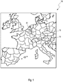
- Figure 1 shows in a schematic representation a section of a digital navigation map 10.
- the digital navigation map 10 comprises several map segments 11 and corresponds to the European area, but can also map any other section of the earth's surface.
- a back-end system provides a plurality of update packages each assigned to a map segment 11 of the digital navigation map 10, which are transmitted to a user's terminal as required.
- the update packages are provided by the back-end system as complete update packages and as incremental update packages.
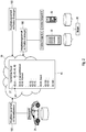
- FIG. 2 shows a schematic representation of a first section of an embodiment of the method according to the invention.
- a control device of a vehicle 31 of the user 30 or a mobile device of the user 30, here a smartphone 32 or a tablet 33, or a stationary device of the user 30, here a notebook 34 (see FIG Figure 7 ) an update note 41 is generated 100 and transmitted to the backend system 39.
- the update note 41 comprises a segment identifier 27 assigned to a map segment and a specific note type 42, 43, 44, 45.
- the backend system 39 is designed as an internet cloud and enters the transmitted update note 41 in a note list 40 assigned to the user 30.
- the backend system 39 changes update notes 41 entered in the note list 40, in particular by changing the note type 42, 43, 44, 45 depending on an interest, ie a movement behavior of the user 30 and / or generates update notes 41 itself and enters them in the note list 40 .
- Figure 3 shows a further section of an embodiment of the method according to the invention in a flowchart: the backend system 39 generates 300 a priority list 50 from the comment list 40 and generates 400 a transmission list 60 from the priority list 50.
- FIG. 4 shows in an enlarged representation a detail of the in Figure 3 section shown.
- a priority entry 55 with the segment identifier 27 of the update comment 41 is generated for each update comment 41 included in the comment list 40.
- the generated priority entry 55 is assigned according to a priority 52 assigned to it by means of a priority table 51 and dependent on the comment type 42, 43, 44, 45 of the update comment 41 (see FIG Figure 5 ) sorted 300 into a priority list 50 assigned to the user 30.
- FIG. 5 shows in an enlarged representation a detail of the in Figure 4 details shown.
- Each entry of the priority table 51 includes one Priority 52, a prioritization reason 53, which includes comment types 42, 43, 44, 45, and further prioritization criteria 54 for differentiating within a priority 52.
- Figure 6 shows in an enlarged representation a further detail of the in Figure 3 section shown.
- the backend system 39 For each priority entry 55 of the priority list 50, the backend system 39 generates a package reference 26 with the segment identifier 27 of the priority entry 55, the version number 72 of the version entry 71 comprising the segment identifier 27 and a version number of the update package provided, as well as a package reference that is assigned to the terminal device 26 comprehensive transmission entry 61 and sorts the generated transmission entry 61 according to the position of the priority entry 55 in the priority list 50 in the transmission list 60 assigned to the terminal and the user 30 a 400.
- the transmission entry 61 is generated with a package reference 26 referencing a complete update package if a positive version difference between a version number of the update package provided and a version number 72 of an update package installed in the terminal corresponding to the update package provided is greater than a certain difference value, or with a Incremental update package referencing package reference 26 is generated if the version difference is at most equal to the determined difference value.
- the terminal After receiving the transmission list 60, the terminal automatically requests each update packet referenced by a packet reference 26 of a transmission entry 61 of the transmission list 60 generated and transmitted by the backend system 39 from the backend system 39 in accordance with the sequence of the transmission entries 61 in the transmission list 60.
- FIG. 7 shows in a schematic representation a further section of an embodiment of the method according to the invention.
- a provided update package 25 is transmitted from the backend system 39 via a cellular network 37 to the control device of the vehicle 31 (Over The Air Update, OTA Update).
- the update package 25 is transferred via the cellular network 37 to the smartphone 32 and from the smartphone 32 wirelessly to the control unit of the vehicle 31 or - not shown - via the cellular network 37 to the tablet and from the tablet wirelessly to the control unit of the vehicle 31 transferred (Over The App Update).
- the update package 25 is transmitted via a stationary Internet 38 to a local wireless network 36 of the user 30 and from the local wireless network 36 to the control device of the vehicle 31 (Over The WiFi Update).
- the update package 25 is transferred via the stationary Internet 38 to the notebook 34 and from the notebook 34 by means of a mobile data memory of the user 30, here by means of a USB stick 35, to the control unit of the vehicle 31 (customer update).
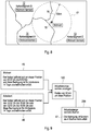
- Figure 8 shows in an enlarged representation a detail of the in Figure 1 shown digital navigation map 10 with a place of residence.
- the detail shows three map segments 12, 13, 14, a center point 15 that maps to the place of residence, which is arranged in the map segment 13 and a circular place of residence area 17 defined by a place of residence radius 16 of 50 km around the center point 15.
- the circular place of residence area 17 also overlaps the three map segments 12, 13, 14.
- Figure 9 shows in a flow chart a on the in Figure 9 Shown detail-related section of an embodiment of the method according to the invention. If a first residence condition 45 that the terminal device is located in the center 15 for a specific first period of at least 14 days is fulfilled every day between 12:00 a.m. and 6:00 a.m. in the early morning, then three Update notes 41 are generated 100 with one of the three segment identifiers 12, 13, 14 assigned to the map segments 12, 13, 14 and the note type “place of residence” 42.
- a first work location condition 46 is that for a certain first period of at least 14 days, the terminal device is in the center every day between 10:00 a.m. and 3:00 p.m. or between 12:00 p.m. and 6:00 p.m. in the evening 15 is arranged, is fulfilled, three update notes 41 are generated 100 each with one of the three segment identifiers 12, 13, 14 assigned to the map segments 12, 13, 14 and the note type “work location” 43.
- Figure 10 shows in an enlarged representation the in Figure 9 shown detail with three destinations.
- the detail includes three map segments 12, 13, 14, three center points 18, 21, 23 each corresponding to a destination, of which the first two center points 18, 21 are arranged in map segment 12 and the third center 23 in map segment 14.
- Each center point 18, 21, 23 defines a circular target location area 20, 22, 24 around the respective one, defined by a target location radius 19 of 5 km Center point 18, 21, 23.
- the circular destination area 20 overlaps with the map segment 14.
- the circular destination area 22 overlaps with the map segments 12, 13, 14.
- the circular destination area 24 overlaps with the map segments 12, 14.
- Figure 11 shows in a flow chart a on the in Figure 11 Shown detail-related section of an embodiment of the method according to the invention. If a first destination condition 48, that the user 30 has entered a destination corresponding to the center point 18 and has covered a certain minimum portion of a route to the destination, is met, an update note 41 with the segment identifier 14 assigned to the map segment 14 and the note type " Destination "44 is generated 100. Correspondingly, three update notes 41 are created for the center 21, each with one of the three segment identifiers 12, 13, 14 assigned to the map segments 12, 13, 14 and the comment type" destination "44, and two update notes 41 each for the center 23 generated 100 with one of the two segment identifiers 12, 14 assigned to the map segments 12, 14 and the comment type "destination" 44.
- the method according to the invention offers the advantage that the map segments 11, 12, 13, 14 of the digital navigation map 10 installed in a terminal of the user 30 are dependent on the behavior and the Interest of the user 30 can be updated. Because map segments 11, 12, 13, 14 that are of no interest to the user 30 are not updated or at most very rarely updated, the data volume to be transmitted for updating the digital navigation map 10 is reduced.
- update packages 41 can also be transferred to the control unit of vehicle 31 via wireless network 36, notebook 34 with USB stick 35 and via smartphone 32 and tablet 33 of user 30. In this way, the data volume to be transmitted via a mobile radio network 37 is reduced, which is associated with a corresponding reduction in mobile communication costs.
- update packets 41 can be transmitted in advance or with a specific maximum time delay in order to use different transmission paths from the mobile radio network 37.
Landscapes
- Engineering & Computer Science (AREA)
- Radar, Positioning & Navigation (AREA)
- Remote Sensing (AREA)
- Automation & Control Theory (AREA)
- Physics & Mathematics (AREA)
- General Physics & Mathematics (AREA)
- Navigation (AREA)
Description
- Die vorliegende Erfindung betrifft ein Verfahren zum Aktualisieren einer mehrere Kartensegmente umfassenden digitalen Navigationskarte, bei dem ein Backendsystem mehrere jeweils einem Kartensegment der digitalen Navigationskarte zugeordnete Aktualisierungspakete bereitstellt und ein bereitgestelltes Aktualisierungspaket in ein Endgerät eines Nutzers übertragen wird.
- Digitale Navigationskarten dienen in vielen Fahrzeugen und mobilen Endgeräten, beispielsweise in Tablets oder Smartphones, dazu, während einer Bewegung des jeweiligen Fahrzeugs oder eines Nutzers des jeweiligen mobilen Endgeräts von einem Ausgangspunkt zu einem Zielpunkt entlang einer bestimmten oder gewählten Route zu navigieren. Insbesondere Fahrzeuge mit teilweiser oder vollständiger Selbstfahrfunktion (autonomes Fahren) sind auf hochpräzise digitale Navigationskarten angewiesen.
- Für ein jederzeit sicheres Navigieren eines Fahrzeugs oder eines Nutzers eines mobilen Endgeräts ist es erforderlich, eine in einem Steuergerät des Fahrzeugs oder in dem mobilen Endgerät gespeicherte digitale Navigationskarte stets auf einem aktuellen Stand zu halten. Dies kann durch fortlaufend wiederholtes Aktualisieren der digitalen Navigationskarte erreicht werden. Dazu wird eine jüngere Version der digitalen Navigationskarte von einem Backendsystem gewöhnlich über eine drahtlose Verbindung in das Steuergerät des Fahrzeugs oder das mobile Endgerät übertragen.
- Für eine bestmögliche Aktualität wird die digitale Navigationskarte automatisch, d. h. ohne initiatives Mitwirken des Nutzers, aktualisiert, sobald eine jüngere Version auf dem Backendsystem verfügbar ist. Bei einer Aktualisierung während einer Bewegung des Fahrzeugs oder des Nutzers des mobilen Endgeräts können allerdings die Navigationsfunktion oder weitere Funktionen des Fahrzeugs bzw. des mobilen Endgeräts beeinträchtigt sein. Dies ist beispielsweise für eine sicherheitskritische Funktion des Fahrzeugs nicht hinnehmbar.
- Zum Vermeiden einer funktionalen Beeinträchtigung des Fahrzeugs während einer Fahrt kann die digitale Navigationskarte während einer Parkphase aktualisiert werden. Das Übertragen einer jüngeren Version der digitalen Navigationskarte in das Steuergerät des Fahrzeugs und das Aktualisieren der in dem Steuergerät des Fahrzeugs gespeicherten digitalen Navigationskarte verbrauchen aber eine elektrische Energie, welche einer Batterie des Fahrzeugs entnommen wird. Es besteht daher die Gefahr, dass die Batterie durch das Aktualisieren der digitalen Navigationskarte während einer Parkphase des Fahrzeugs so weit entladen wird, dass eine nach dem Aktualisieren in der Batterie verbleibende elektrische Energie für ein Starten des Fahrzeugs unzureichend ist.
- Abgesehen davon kann es zu einem undefinierten Zwischenzustand der digitalen Navigationskarte in dem Steuergerät des Fahrzeugs kommen, wenn die Dauer der Parkphase für ein vollständiges Aktualisieren der digitalen Navigationskarte unzureichend ist. In dem undefinierten Zwischenzustand kann die gespeicherte digitale Navigationskarte unbrauchbar sein, was ein Wiederholen der Aktualisierung erforderlich macht.
- So offenbart die
DE 10 2015 014 049 A1 ein Verfahren zum Aktualisieren einer Software, welche in einem Steuergerät eines Fahrzeugs gespeichert ist. Bei dem Verfahren erfolgt das Aktualisieren der Software während einer Parkphase des Fahrzeugs, um während einer Fahrt des Fahrzeugs eine Beeinträchtigung des Steuergeräts aufgrund einer Aktualisierung auszuschließen. Zunächst wird ein Energiebedarf für die Aktualisierung prognostiziert und ein Energievorrat des Fahrzeugs ermittelt. Die Software wird unter der Bedingung aktualisiert, dass der Energievorrat abzüglich des prognostizierten Energiebedarfs eine bestimmte Mindestenergiemenge nicht unterschreitet. Weiterhin kann ein Zeitbedarf für die Aktualisierung prognostiziert werden und ein Parkverhalten eines Fahrers des Fahrzeugs erlernt werden. Die Software wird aktualisiert, wenn eine erlernte Parkdauer größer als der prognostizierte Zeitbedarf ist. - Ein weiteres Problem einer digitalen Navigationskarte besteht darin, dass es sehr aufwändig ist, sich fortlaufend ändernde Umgebungs- und Straßenbedingungen zu erfassen, entsprechend angepasste jüngere Versionen der digitalen Navigationskarte zu erzeugen und diese zeitnah zum Übertragen bereitzustellen. Demzufolge weist im Allgemeinen sogar eine bereitgestellte jüngste Version der digitalen Navigationskarte einen Unterschied zu den tatsächlichen Umgebungs- und Straßenbedingungen auf.
- Zum Verringern dieses Unterschieds offenbart die
DE 10 2012 212 740 A1 ein System und ein Verfahren zum Aktualisieren einer digitalen Navigationskarte. Das System umfasst einen Backendserver, welcher eine digitale Navigationskarte zum Übertragen bereitstellt, und mehrere Fahrzeuge, welche jeweils ein Steuergerät mit einer von dem Backendserver übertragenen und in dem Steuergerät gespeicherten digitalen Navigationskarte sowie mindestens einen Umgebungssensor und/oder Fahrzeugsensor umfassen. Bei dem Verfahren werden mit den Sensoren Umgebungs- und/oder Fahrzeugdaten erfasst und zu dem Backendserver übertragen. Der Backendserver ermittelt Unterschiede zwischen der bereitgestellten Navigationskarte und von den Fahrzeugen übertragenen Umgebungs- und/oder Fahrzeugdaten und aktualisiert entsprechend den ermittelten Unterschieden die bereitgestellte Navigationskarte, die dann in die Steuergeräte der Fahrzeuge übertragen wird. - Eine digitale Navigationskarte weist aufgrund einer großen Fläche des abgebildeten Gebiets und entsprechend vieler enthaltener Details üblicherweise ein großes Datenvolumen auf. Entsprechend erfordert eine vollständige Aktualisierung der digitalen Navigationskarte viel Zeit und verursacht zudem hohe Kosten, insbesondere bei Nutzung einer Mobilfunkverbindung. Infolgedessen gehen Bestrebungen dahin, den Aufwand für das Aktualisieren der digitalen Navigationskarte zu verringern.
- So offenbart die
EP 1 870 671 A1 ein System und ein Verfahren zum Aktualisieren einer digitalen Navigationskarte, welche mehrere gitterartig angeordnete quadratische Kartensegmente umfasst. Das System umfasst ein Fahrzeug mit einem Steuergerät und einer in dem Steuergerät gespeicherten digitalen Navigationskarte sowie einen Backendserver mit einer in dem Backendserver gespeicherten Navigationskarte. Unmittelbar nach einem Anlassen der Fahrzeugs fordert das Steuergerät von dem Backendserver eine Aktualisierungsinformation betreffend ein bestimmtes quadratisches Gebiet an, welches einen bestimmten Ort etwa in seiner Mitte aufweist, beispielsweise einen von einem Fahrer des Fahrzeugs eingegebenen Wohnort oder einen von dem Fahrer eingegebenen Zielort. Der Backendserver überträgt daraufhin eine Differenzinformation mit aktualisierten Kartensegmenten betreffend das bestimmte quadratische Gebiet in das Steuergerät. Ausgehend von der Differenzinformation fordert das Steuergerät mit abnehmender Priorität zunächst aktualisierte Kartensegmente eines zentralen quadratischen Teilgebiets und dann jeweils das zentrale Teilgebiet umgebender ringförmiger Teilgebiete um den Wohnort an und erhält die entsprechenden aktualisierten Kartensegmente von dem Backendserver übertragen. -
EP 1 909 068 A2 offenbart ein weiteres Verfahren zum Aktualisieren einer digitalen Navigationskarte, welche mehrere gitterartig angeordnete rechteckige Kartensegmente umfasst. - Bei diesem Verfahren kann der Backendserver einer starken Last ausgesetzt sein, wenn von vielen Fahrzeugen gleichzeitig aktualisierte Kartensegmente angefordert werden. Zudem können von dem Backendserver tatsächlich nicht benötigte Kartensegmente übertragen werden, wenn der Fahrer des Fahrzeugs eine Änderung des Wohnorts oder des Zielorts nicht eingibt. Außerdem nutzt das Verfahren als Aktualisierungsweg ein Mobilfunknetz, welches in manchen Gebieten nicht mit genügender Qualität verfügbar ist.
- Der Erfindung liegt daher die Aufgabe zugrunde, ein verbessertes Verfahren zum Aktualisieren einer mehrere Kartensegmente umfassenden digitalen Navigationskarte vorzuschlagen, welches flexibler ist und die beschriebenen Nachteile vermeidet.
- Ein Gegenstand der vorliegenden Erfindung ist ein Verfahren zum Aktualisieren einer mehrere Kartensegmente umfassenden digitalen Navigationskarte gemäß Anspruch 1, bei dem ein Backendsystem mehrere jeweils einem Kartensegment der digitalen Navigationskarte zugeordnete Aktualisierungspakete bereitstellt und ein bereitgestelltes Aktualisierungspaket in ein Endgerät eines Nutzers übertragen wird. Das Backendsystem stellt für jedes Kartensegment der digitalen Navigationskarte ein versioniertes Aktualisierungspaket bereit, um es auf viele Endgeräte zu verteilen. Mit den bereitgestellten Aktualisierungspaketen kann eine in einem Endgerät installierte digitale Navigationskarte individuell und partiell, d. h. durch ein an ein Verhalten oder ein Interesse des Nutzers angepasstes Installieren einzelner Kartensegmente aktualisiert werden. Bei dem Backendsystem kann es sich um einen oder mehrere Backendserver, welche von einem Anbieter der digitalen Navigationskarte betrieben werden, oder auch um einen speziellen Bereich einer allgemein zugänglichen Internet-Cloud handeln. Fachleuten ist geläufig, dass die dafür erforderliche Kommunikation erst nach einer Authentisierung und Autorisierung des Nutzers von dem Backendsystem zugelassen wird. Bei dem Verfahren wird zum Übertragen von Aktualisierungspaketen vorteilhaft ein Übertragungsprotokoll genutzt, nach dem das Übertragen eines Aktualisierungspakets in ein Endgerät eines Nutzers jederzeit unterbrochen und nach einer Unterbrechung fortgesetzt wird. Auf diese Weise kann ein wiederholtes Teilübertragen eines Aktualisierungspakets verhindert werden.
- Erfindungsgemäß fordert das Endgerät automatisch jedes von einer Paketreferenz eines Übertragungseintrags einer von dem Backendsystem erzeugten und übermittelten Übertragungsliste referenzierte bereitgestellte Aktualisierungspaket von dem Backendsystem entsprechend der Reihenfolge der Übertragungseinträge in der Übertragungsliste an. Auf diese Weise wird die Voraussetzung für eine hybride Aktualisierungslogik geschaffen, nach der das Backendsystem wesentlich beeinflusst, welche Kartensegmente in welcher Reihenfolge und zu welchem Zeitpunkt in das Endgerät übertragen werden. Das Backendsystem kann dadurch abweichend von üblichen Aktualisierungslogiken überwiegend als Master fungieren. Infolgedessen kann der Ablauf des Verfahrens allein durch einen Eingriff in das Backendsystem, d. h. ohne ein Konfigurieren des Endgeräts, jederzeit verändert werden. Vor allem bei einer üblicherweise sehr großen Anzahl von Nutzern und Endgeräten lässt sich auf diese Weise mittels eines Anpassens der Aktualisierungslogik ein insgesamt vorteilhafter, insbesondere für einen Betreiber des Backendsystems kostengünstiger Ablauf des Verfahrens einstellen.
- Infolgedessen können neben Betriebsbedingungen eines beteiligten Endgeräts auch Betriebsbedingungen des Backendsystems, beispielsweise eine aktuelle Last des Backendsystems, bei dem Aktualisieren der digitalen Navigationskarte berücksichtigt werden.
- Erfindungsgemäß erzeugt das Endgerät einen Aktualisierungsvermerk mit einem einem Kartensegment zugeordneten Segmentkennzeichner und einem bestimmten Vermerktyp und übermittelt den erzeugten Aktualisierungsvermerk an das Backendsystem. Der Aktualisierungsvermerk bildet einen konkreten auf ein Kartensegment bezogenen Aktualisierungsbedarf des Endgeräts ab. Der Vermerktyp kann als Unterscheidungsmerkmal der Aktualisierungsvermerke dienen und folglich ein differenziertes Verarbeiten von Aktualisierungsvermerken verschiedener Vermerktypen ermöglichen. Beispielsweise kann der Vermerktyp ein Kartensegment nach seiner Bedeutung für den Nutzer spezifizieren. Ebenso können anhand des Vermerktyps unterschiedliche Aktualisierungswege unterschieden werden, um ein Aktualisierungsverhalten des Nutzers differenziert abzubilden.
- Vorteilhaft ist hierbei weiterhin, dass ausschließlich das Endgerät Positionsdaten nutzt, um anzufordernde Kartensegmente zu bestimmen. An das Backendsystem werden keine Positionsdaten, sondern lediglich ein größeres Gebiet identifizierende Segmentkennzeichner übermittelt. Dadurch können datenschutzrechtliche Probleme vermieden werden. Aufgrund der Zuordnung der Vermerkliste zu einem Nutzer kann derselbe Nutzer mehrere unterschiedliche Endgeräte nutzen, um Aktualisierungsvermerke zu erzeugen und an das Backendsystem zu übertragen.
- Das Backendsystem trägt erfindungsgemäß den übermittelten Aktualisierungsvermerk in eine dem Nutzer zugeordnete Vermerkliste ein. Das Backendsystem kann auch einen in die Vermerkliste eingetragenen Aktualisierungsvermerk, insbesondere durch Ändern des Vermerktyps verändern, und/oder selbst einen Aktualisierungsvermerk erzeugen. Die Aktualisierungsvermerke des Nutzers werden also unabhängig von dem jeweils genutzten Endgerät in derselben Vermerkliste gesammelt. Zum einen können auf diese Weise redundante Übertragungen von Kartensegmenten vermieden werden. Zum anderen können sämtliche Aktualisierungsvermerke des Nutzers für eine intelligente Aktualisierungsstrategie ausgewertet werden. Abgesehen davon, spiegeln die Aktualisierungsvermerke in der Vermerkliste des Nutzers ein Interesse, d. h. ein Bewegungsverhalten und ein Aktualisierungsverhalten des Nutzers wieder und ermöglichen dem Backendsystem, den Aktualisierungsbedarf des Nutzers zu erlernen und die Aktualisierungsstrategie auf den Nutzer abzustimmen.
- Weiterhin erzeugt das Backendsystem zu jedem von der Vermerkliste umfassten Aktualisierungsvermerk einen Prioritäteneintrag mit dem Segmentkennzeichner des Aktualisierungsvermerks und sortiert den erzeugten Prioritäteneintrag entsprechend einer ihm mittels einer Prioritätentabelle zugeordneten und von dem Vermerktyp des Aktualisierungsvermerks abhängigen Priorität in eine dem Nutzer zugeordnete Prioritätenliste ein. Die Prioritätentabelle ordnet jedem Vermerktyp eines Aktualisierungsvermerks einen Prioritätswert zu, welcher die Dringlichkeit der Aktualisierung angibt. Innerhalb eines Prioritätswerts kann abhängig von weiteren den Aktualisierungsvermerk betreffenden Priorisierungskriterien eine feinere Differenzierung möglich sein.
- Erfindungsgemäß installiert das Endgerät ein übertragenes Aktualisierungspaket und übermittelt eine Versionsnummer des installierten Aktualisierungspakets an das Backendsystem. Das Backendsystem erzeugt einen Versionseintrag mit der übermittelten Versionsnummer und dem Segmentkennzeichner des installierten Aktualisierungspakets und trägt den erzeugten Versionseintrag in eine dem Endgerät zugeordnete Versionsliste ein. Damit kennt das Backendsystem in jedem Zeitpunkt die Aktualisierungsstände der Kartensegmente der digitalen Navigationskarte in jedem Endgerät des Benutzers.
- Erfindungsgemäß erzeugt das Backendsystem zu jedem Prioritäteneintrag der Prioritätenliste anhand der dem Endgerät zugeordneten Versionsliste eine Paketreferenz mit dem Segmentkennzeichner des Prioritäteneintrags, der Versionsnummer des den Segmentkennzeichner umfassenden Versionseintrags und einer Versionsnummer des bereitgestellten Aktualisierungspakets, einen die erzeugte Paketreferenz umfassenden Übertragungseintrag und sortiert den erzeugten Übertragungseintrag entsprechend der Position des Prioritäteneintrags in der Prioritätenliste in die dem Endgerät und dem Nutzer zugeordnete Übertragungsliste ein. Dieser Verfahrensschritt kann auch ein erlerntes Aktualisierungsverhalten berücksichtigen, beispielsweise zu welchen Zeitpunkten und mit welchen Endgeräten der Nutzer Aktualisierungsvermerke erzeugt und übermittelt. So kann für ein bestimmtes Aktualisierungspaket eine Paketreferenz erst nach einer Aktualisierungsfrist in die einem zweiten Endgerät des Nutzers zugeordnete Übertragungsliste einsortiert werden, falls das bestimmte Aktualisierungspaket bis zum Ablauf der Aktualisierungsfrist nicht in ein erstes Endgerät des Nutzers übertragen wurde. Der Fachmann kann weitere Aspekte eines Aktualisierungsverhaltens eines Nutzers erkennen und bei dem Erzeugen der Übertragungsliste berücksichtigen.
- In einer Ausführungsform erzeugt das Endgerät einen Aktualisierungsvermerk mit dem Vermerktyp "Wohnort", wenn das dem Kennzeichner zugeordnete Kartensegment mit einem Wohnortgebiet überlappt, welches durch einen Mittelpunkt und insbesondere kreisförmig durch einen bestimmten Wohnortradius definiert ist, und für den Mittelpunkt eine erste Wohnortbedingung erfüllt ist, dass das Endgerät für einen bestimmten ersten Zeitraum täglich jeweils zwischen einer Nachtstunde und einer frühen Morgenstunde in dem Mittelpunkt angeordnet ist. Infolge des tageszeitlichen Kriteriums für das Bestimmen des Wohnorts kann eine Eingabe des Wohnorts durch den Nutzer entfallen. Als erster Zeitraum können beispielsweise 14 Tage bestimmt werden. Wenn ein Nutzer die wesentlichen Nachtstunden 14 Tage lang ausnahmslos an demselben Ort verbringt, ist dieser Ort mit hoher Wahrscheinlichkeit sein Wohnort.
- Durch das kreisförmige Wohnortgebiet wird sichergestellt, dass mit dem Vermerktyp "Wohnort" versehene Aktualisierungsvermerke allen Kartensegmenten zugeordnet werden, die zu einem Gebiet um den Wohnort mit dem bestimmten Wohnortradius korrespondieren. Dadurch wird die digitale Navigationskarte mindestens innerhalb eines durch den Wohnortradius definierten Abstands um den Wohnort des Nutzers aktualisiert. Dies wird Wohnorten gerecht, welche am Rand eines Kartensegments angeordnet sind. Als Wohnortradius können beispielsweise 50 km bestimmt werden. Für den täglichen Bedarf entfernt sich der Nutzer gewöhnlich nicht weiter als 50 km von dem Wohnort.
- Ein den Vermerktyp "Wohnort" umfassender Aktualisierungsvermerk wird gelöscht, wenn für den Mittelpunkt eine zweite Wohnortbedingung erfüllt ist, dass das Endgerät für einen bestimmten zweiten Zeitraum täglich jeweils zwischen der Nachtstunde und der frühen Morgenstunde nicht in dem Mittelpunkt angeordnet ist. Der zweite Zeitraum gewährleistet also, dass veraltete Aktualisierungsvermerke aus der Vermerkliste gelöscht werden. Er sollte so lang bestimmt sein, dass eine beispielsweise urlaubsbedingte längere Abwesenheit vom Wohnort nicht zum Löschen eines Aktualisierungsvermerks vom Vermerktyp "Wohnort" führt, beispielsweise vier Wochen. Das Löschen veralteter Aktualisierungsvermerke verhindert überflüssige Aktualisierungen und verringert das zum Aktualisieren insgesamt übertragene Datenvolumen.
- In einer weiteren Ausführungsform erzeugt das Endgerät einen Aktualisierungsvermerk mit dem Vermerktyp "Arbeitsort", wenn das dem Kennzeichner zugeordnete Kartensegment mit einem Arbeitsortgebiet überlappt, welches durch einen Mittelpunkt und insbesondere kreisförmig durch einen bestimmten Arbeitsortradius definiert ist, und für den Mittelpunkt eine erste Arbeitsortbedingung erfüllt ist, dass das Endgerät für einen bestimmten ersten Zeitraum täglich jeweils zwischen einer Vormittagsstunde und einer Nachmittagsstunde oder zwischen einer Mittagsstunde und einer Abendstunde in dem Mittelpunkt angeordnet ist. Infolge des tageszeitlichen Kriteriums für das Bestimmen des Arbeitsorts kann eine Eingabe des Arbeitsorts durch den Nutzer entfallen. Als erster Zeitraum können beispielsweise 14 Tage bestimmt sein. Wenn ein Nutzer die erste Tageshälfte oder die zweite Tageshälfte 14 Tage lang ausnahmslos an demselben Ort verbringt, ist dieser Ort mit hoher Wahrscheinlichkeit sein Arbeitsort.
- Durch das kreisförmige Arbeitsortsgebiet wird sichergestellt, dass mit dem Vermerktyp "Arbeitsort" versehene Aktualisierungsvermerke allen Kartensegmenten zugeordnet sind, die zu einem Gebiet um den Arbeitsort mit dem bestimmten Arbeitsortradius korrespondieren. Dadurch wird die digitale Navigationskarte mindestens innerhalb eines durch den Arbeitsortradius definierten Abstands um den Arbeitsort des Nutzers aktualisiert. Dies wird Arbeitsorten gerecht, welche am Rand eines Kartensegments angeordnet sind. Als Arbeitsortradius können beispielsweise 50 km bestimmt werden. Gewöhnlich entfernt sich der Nutzer während der Arbeit nicht weiter als 50 km von dem Arbeitsort.
- Ein den Vermerktyp "Arbeitsort" umfassender Aktualisierungsvermerk wird gelöscht, wenn für den Mittelpunkt eine zweite Arbeitsortbedingung erfüllt ist, dass das Endgerät für einen bestimmten zweiten Zeitraum täglich jeweils zwischen der Vormittagsstunde und der Nachmittagsstunde oder zwischen der Mittagsstunde und der Abendstunde nicht in dem Mittelpunkt angeordnet ist. Der zweite Zeitraum gewährleistet also, dass veraltete Aktualisierungsvermerke aus der Vermerkliste gelöscht werden. Er sollte so lang bestimmt sein, dass eine beispielsweise urlaubsbedingte längere Abwesenheit vom Arbeitsort nicht zum Löschen eines Aktualisierungsvermerks vom Vermerktyp "Arbeitsort" führt, beispielsweise vier Wochen. Das Löschen veralteter Aktualisierungsvermerke verhindert überflüssige Aktualisierungen und verringert das zum Aktualisieren insgesamt übertragene Datenvolumen.
- In einer Ausführungsform erzeugt das Endgerät einen Aktualisierungsvermerk mit dem Vermerktyp "Zielort", wenn das dem Kennzeichner zugeordnete Kartensegment mit einem Zielortgebiet überlappt, welches durch einen Mittelpunkt und insbesondere kreisförmig durch einen bestimmten Zielortradius definiert ist, und für den Mittelpunkt eine erste Zielortbedingung erfüllt ist, dass der Mittelpunkt von dem Nutzer als Zielort einer Fahrstrecke in das Endgerät eingegeben hat und einen bestimmten Mindestanteil der Fahrstrecke zurückgelegt hat. Aktualisierungsvermerke dieses Vermerktyps betreffen üblicherweise Gebiete, welche von dem Nutzer selten und/oder nicht regelmäßig aufgesucht werden. Sie stellen sicher, dass die digitale Navigationskarte in Gebieten um den Zielort aktualisiert wird. Um nicht bereits durch eine ggf. irrtümliche Eingabe eines Zielorts einen Aktualisierungsvermerk dieses Vermerktyps zu erzeugen, muss der Nutzer eine nicht unwesentliche Mindeststrecke auf der Fahrtroute zu dem Zielort zurückgelegt haben.
- Durch das kreisförmige Zielortgebiet oder das kreisförmige Zwischenstoppgebiet wird sichergestellt, dass mit dem Vermerktyp "Zielort" versehene Aktualisierungsvermerke allen Kartensegmenten zugeordnet sind, die zu einem Gebiet um den Zielort mit dem bestimmten Zielortradius korrespondieren. Dadurch wird die digitale Navigationskarte mindestens innerhalb eines durch den Zielortradius definierten Abstands um den Zielort oder den Zwischenstopp aktualisiert. Als Zielortradius können beispielsweise 5 km bestimmt werden. Gewöhnlich entfernt sich der Nutzer während einer Fahrt nicht weiter als 5 km von dem Zielort.
- Ein den Vermerktyp "Zielort" umfassender Aktualisierungsvermerk wird gelöscht, wenn für den Mittelpunkt eine zweite Zielortbedingung erfüllt ist, dass der Mittelpunkt von dem Nutzer als Zielort der Fahrstrecke in dem Endgerät gelöscht worden ist und das Endgerät nicht in dem zugeordneten Kartensegment angeordnet ist. Demnach werden auch nicht mehr benötigte Aktualisierungsvermerke des Vermerktyps "Zielort" oder "Zwischenstopp" aus der Vermerkliste des Nutzers gelöscht, wodurch unnötige Aktualisierungen vermieden werden.
- Der Fachmann kann einen weiteren Vermerktyp "Zwischenstopp" ohne Weiteres in Analogie zu dem Vermerktyp "Zielort" vorsehen. Selbstverständlich sind die genannten Vermerktypen lediglich beispielhaft und nicht einschränkend zu verstehen. Andere Vermerktypen können "Aktueller Aufenthaltsort", "Fahrstrecke", "Fahrzeugumgebung", "Umgebung des mobilen Endgeräts", "Ehemaliger Zielort", "Ehemalige Fahrstrecke", "Prognose" usw. mit jeweils geeigneten ersten und zweiten Bedingungen sein.
- In einer bevorzugten Ausführungsform wird der Aktualisierungsvermerk von einem Steuergerät eines Fahrzeugs des Nutzers oder einem mobilen Endgerät des Nutzers, insbesondere einem Smartphone oder einem Tablet, oder einem stationären Endgerät des Nutzers, insbesondere einem Notebook, erzeugt und an das Backendsystem übermittelt. Sowohl ein Steuergerät eines Fahrzeugs als auch mobile Endgeräte umfassen üblicherweise eine Einrichtung zur Positionsermittlung, beispielsweise einen Satellitenempfänger zum Empfangen von GPS-Daten (Global Positioning System), sowie einen Zeitmesser. Mittels dieser Einrichtungen kann zu einem Kartensegment anhand einer Position des Endgeräts und einer Uhrzeit ein entsprechender Aktualisierungsvermerk mit einem passenden Vermerktyp erzeugt werden.
- In weiteren Ausführungsformen wird ein bereitgestelltes Aktualisierungspaket über ein Mobilfunknetz in das Steuergerät des Fahrzeugs und/oder über das Mobilfunknetz in das Smartphone und aus dem Smartphone drahtlos in das Steuergerät des Fahrzeugs und/oder über das Mobilfunknetz in das Tablet und aus dem Tablet drahtlos in das Steuergerät des Fahrzeugs übertragen und/oder wird ein bereitgestelltes Aktualisierungspaket über ein stationäres Internet in ein lokales Drahtlosnetzwerk des Nutzers und aus dem lokalen Drahtlosnetzwerk in das Steuergerät des Fahrzeugs und/oder über das stationäre Internet in das Notebook und von dem Notebook mittels eines mobilen Datenspeichers des Nutzers, insbesondere mittels eines USB-Sticks, in das Steuergerät des Fahrzeugs übertragen. Zum Übertragen eines bereitgestellten Aktualisierungspakets nutzt das Verfahren mehrere unterschiedliche Aktualisierungswege, die sich durch die jeweiligen Kommunikationskosten unterscheiden. Auf diese Weise kann für jedes Aktualisierungspaket eine hinsichtlich Zeitpunkt und Kosten günstige Übertragung bestimmt werden. Beispielsweise können Aktualisierungspakete während der Aktualisierungsfrist von einem teuren Übertragen über das Mobilfunknetz ausgeschlossen sein, wenn sie von dem Nutzer gewöhnlich auf anderen Aktualisierungswegen übertragen werden und ein Aktualisieren nicht dringend erforderlich ist. Das Steuergerät des Fahrzeugs kann zum Übertragen von Aktualisierungspaketen während eines Parkens des Fahrzeugs eine maximale Übertragungsdauer definieren. Wenn die maximale Übertragungsdauer erreicht ist, wird die Übertragung abgebrochen und zu einem späteren Zeitpunkt fortgesetzt. Auf diese Weise wird ein Entladen einer Batterie des Fahrzeugs während des Parkens vermieden. Ferner kann das Steuergerät derart konfiguriert sein, dass Funktionen des Steuergeräts, die von dem Übertragen eines Aktualisierungspakets verschieden sind, nicht beeinträchtigt sind, wenn das Aktualisierungspaket während einer Fahrt des Fahrzeugs übertragen wird.
- In einer Ausführungsform wird das Aktualisierungspaket als ein vollständiges Aktualisierungspaket und als ein inkrementelles Aktualisierungspaket bereitgestellt und der Übertragungseintrag mit einer das vollständige Aktualisierungspaket referenzierenden Paketreferenz erzeugt, wenn eine positive Versionsdifferenz zwischen einer Versionsnummer des bereitgestellten Aktualisierungspakets und einer Versionsnummer eines zu dem bereitgestellten Aktualisierungspaket korrespondierenden in dem Endgerät installierten Aktualisierungspakets größer als ein bestimmter Differenzwert ist, oder wird mit einer das inkrementelle Aktualisierungspaket referenzierenden Paketreferenz erzeugt, wenn die Versionsdifferenz höchstens gleich dem bestimmten Differenzwert ist. Mit anderen Worten kann es bei geringen Versionsdifferenzen günstiger sein, ein Kartensegment inkrementell zu aktualisieren. Ein inkrementelles Aktualisierungspaket weist ein geringes Datenvolumen auf und erfordert entsprechend wenig Zeit zum Übertragen. Ab einer bestimmten Versionsdifferenz ist dieser Vorteil allerdings vernachlässigbar, so dass stattdessen ein vollständiges Aktualisierungspaket übertragen werden kann. Entsprechend kann das Backendsystem für jedes Kartensegment ein vollständiges Aktualisierungspaket und mehrere inkrementelle Aktualisierungspakete bereitstellen.
- Die Erfindung ist anhand einer Ausführungsform in den Zeichnungen schematisch dargestellt und wird unter Bezugnahme auf die Zeichnungen weiter beschrieben. Es zeigt:
- Figur 1
- in einer schematischen Darstellung einen Ausschnitt einer digitalen Navigationskarte;
- Figur 2
- in einer schematischen Darstellung einen ersten Abschnitt einer Ausführungsform des erfindungsgemäßen Verfahrens;
- Figur 3
- in einem Ablaufdiagramm einen weiteren Abschnitt einer Ausführungsform des erfindungsgemäßen Verfahrens;
- Figur 4
- in einer vergrößerten Darstellung ein Detail des in
Figur 3 gezeigten Abschnitts; - Figur 5
- in einer vergrößerten Darstellung ein Detail des in
Figur 4 gezeigten Details; - Figur 6
- in einer vergrößerten Darstellung ein weiteres Detail des in
Figur 3 gezeigten Abschnitts; - Figur 7
- in einer schematischen Darstellung einen weiteren Abschnitt einer Ausführungsform des erfindungsgemäßen Verfahrens;
- Figur 8
- in einer vergrößerten Darstellung ein Detail der in
Figur 1 gezeigten digitalen Navigationskarte mit einem Wohnort; - Figur 9
- in einem Ablaufdiagramm einen auf das in
Figur 8 gezeigte Detail bezogenen Abschnitt einer Ausführungsform des erfindungsgemäßen Verfahrens; - Figur 10
- in einer vergrößerten Darstellung das in
Figur 8 gezeigte Detail mit drei Zielorten; - Figur 11
- in einem Ablaufdiagramm einen auf das in
Figur 10 gezeigte Detail bezogenen Abschnitt einer Ausführungsform des erfindungsgemäßen Verfahrens. -
Figur 1 zeigt in einer schematischen Darstellung einen Ausschnitt einer digitalen Navigationskarte 10. Die digitale Navigationskarte 10 umfasst mehrere Kartensegmente 11 und korrespondiert zu dem europäischen Raum, kann aber auch jeden anderen Abschnitt der Erdoberfläche abbilden. Bei dem erfindungsgemäßen Verfahren zum Aktualisieren der digitalen Navigationskarte 10 stellt ein Backendsystem mehrere jeweils einem Kartensegment 11 der digitalen Navigationskarte 10 zugeordnete Aktualisierungspakete bereit, welche bei Bedarf in ein Endgerät eines Nutzers übertragen werden. Die Aktualisierungspakete werden von dem Backendsystem als vollständige Aktualisierungspakete und als inkrementelle Aktualisierungspakete bereitgestellt. -
Figur 2 zeigt in einer schematischen Darstellung einen ersten Abschnitt einer Ausführungsform des erfindungsgemäßen Verfahrens. Von einem Steuergerät eines Fahrzeugs 31 des Nutzers 30 oder einem mobilen Endgerät des Nutzers 30, hier einem Smartphone 32 oder einem Tablet 33, oder einem stationären Endgerät des Nutzers 30, hier einem Notebook 34 (sieheFigur 7 ), wird ein Aktualisierungsvermerk 41 erzeugt 100 und an das Backendsystem 39 übermittelt. Der Aktualisierungsvermerk 41 umfasst einen einem Kartensegment zugeordneten Segmentkennzeichner 27 und einen bestimmten Vermerktyp 42, 43, 44, 45. Das Backendsystem 39 ist als Internet-Cloud ausgebildet und trägt den übermittelten Aktualisierungsvermerk 41 in eine dem Nutzer 30 zugeordnete Vermerkliste 40 ein. Zudem verändert das Backendsystem 39 in die Vermerkliste 40 eingetragene Aktualisierungsvermerke 41 insbesondere durch Ändern des Vermerktyps 42, 43, 44, 45 abhängig von einem Interesse, d. h. einem Bewegungsverhalten des Nutzers 30 und/oder erzeugt selbst Aktualisierungsvermerke 41 und trägt sie in die Vermerkliste 40 ein. -
Figur 3 zeigt in einem Ablaufdiagramm einen weiteren Abschnitt einer Ausführungsform des erfindungsgemäßen Verfahrens: Das Backendsystem 39 erzeugt 300 aus der Vermerkliste 40 eine Prioritätenliste 50 und erzeugt 400 aus der Prioritätenliste 50 eine Übertragungsliste 60. -
Figur 4 zeigt in einer vergrößerten Darstellung ein Detail des inFigur 3 gezeigten Abschnitts. Zu jedem von der Vermerkliste 40 umfassten Aktualisierungsvermerk 41 wird ein Prioritäteneintrag 55 mit dem Segmentkennzeichner 27 des Aktualisierungsvermerks 41 erzeugt. Der erzeugte Prioritäteneintrag 55 wird entsprechend einer ihm mittels einer Prioritätentabelle 51 zugeordneten und von dem Vermerktyp 42, 43, 44, 45 des Aktualisierungsvermerks 41 abhängigen Priorität 52 (sieheFigur 5 ) in eine dem Nutzer 30 zugeordnete Prioritätenliste 50 einsortiert 300. -
Figur 5 zeigt in einer vergrößerten Darstellung ein Detail des inFigur 4 gezeigten Details. Jeder Eintrag der Prioritätentabelle 51 umfasst eine Priorität 52, einen Priorisierungsgrund 53, welcher Vermerktypen 42, 43, 44, 45 umfasst, sowie weitere Priorisierungskriterien 54 zum Differenzieren innerhalb einer Priorität 52. -
Figur 6 zeigt in einer vergrößerten Darstellung ein weiteres Detail des inFigur 3 gezeigten Abschnitts. Das Backendsystem 39 erzeugt zu jedem Prioritäteneintrag 55 der Prioritätenliste 50 anhand der dem Endgerät zugeordneten Versionsliste 70 eine Paketreferenz 26 mit dem Segmentkennzeichner 27 des Prioritäteneintrags 55, der Versionsnummer 72 des den Segmentkennzeichner 27 umfassenden Versionseintrags 71 und einer Versionsnummer des bereitgestellten Aktualisierungspakets sowie einen die erzeugte Paketreferenz 26 umfassenden Übertragungseintrag 61 und sortiert den erzeugten Übertragungseintrag 61 entsprechend der Position des Prioritäteneintrags 55 in der Prioritätenliste 50 in die dem Endgerät und dem Nutzer 30 zugeordnete Übertragungsliste 60 ein 400. - Der Übertragungseintrag 61 wird mit einer ein vollständiges Aktualisierungspaket referenzierenden Paketreferenz 26 erzeugt, wenn eine positive Versionsdifferenz zwischen einer Versionsnummer des bereitgestellten Aktualisierungspakets und einer Versionsnummer 72 eines zu dem bereitgestellten Aktualisierungspaket korrespondierenden in dem Endgerät installierten Aktualisierungspakets größer als ein bestimmter Differenzwert ist, oder mit einer ein inkrementelles Aktualisierungspaket referenzierenden Paketreferenz 26 erzeugt, wenn die Versionsdifferenz höchstens gleich dem bestimmten Differenzwert ist.
- Nach dem Empfangen der Übertragungsliste 60 fordert das Endgerät automatisch jedes von einer Paketreferenz 26 eines Übertragungseintrags 61 der von dem Backendsystem 39 erzeugten und übermittelten Übertragungsliste 60 referenzierte Aktualisierungspaket von dem Backendsystem 39 entsprechend der Reihenfolge der Übertragungseinträge 61 in der Übertragungsliste 60 an.
-
Figur 7 zeigt in einer schematischen Darstellung einen weiteren Abschnitt einer Ausführungsform des erfindungsgemäßen Verfahrens. Ein bereitgestelltes Aktualisierungspaket 25 wird von dem Backendsystem 39 über ein Mobilfunknetz 37 in das Steuergerät des Fahrzeugs 31 übertragen (Over The Air Update, OTA Update). Alternativ oder zusätzlich wird das Aktualisierungspaket 25 über das Mobilfunknetz 37 in das Smartphone 32 und aus dem Smartphone 32 drahtlos in das Steuergerät des Fahrzeugs 31 bzw. - nicht dargestellt - über das Mobilfunknetz 37 in das Tablet und aus dem Tablet drahtlos in das Steuergerät des Fahrzeugs 31 übertragen (Over The App Update). - Alternativ oder zusätzlich wird das Aktualisierungspaket 25 über ein stationäres Internet 38 in ein lokales Drahtlosnetzwerk 36 des Nutzers 30 und aus dem lokalen Drahtlosnetzwerk 36 in das Steuergerät des Fahrzeugs 31 übertragen (Over The WiFi Update). Alternativ oder zusätzlich wird das Aktualisierungspaket 25 über das stationäre Internet 38 in das Notebook 34 und von dem Notebook 34 mittels eines mobilen Datenspeichers des Nutzers 30, hier mittels eines USB-Sticks 35, in das Steuergerät des Fahrzeugs 31 übertragen (Customer Update).
-
Figur 8 zeigt in einer vergrößerten Darstellung ein Detail der inFigur 1 gezeigten digitalen Navigationskarte 10 mit einem Wohnort. Das Detail zeigt drei Kartensegmente 12, 13, 14, einen zu den Wohnort abbildenden Mittelpunkt 15, welcher in dem Kartensegment 13 angeordnet ist und ein durch einen Wohnortradius 16 von 50 km definiertes kreisförmiges Wohnortgebiet 17 um den Mittelpunkt 15. Das kreisförmige Wohnortgebiet 17 überlappt mit den drei Kartensegmenten 12, 13, 14. -
Figur 9 zeigt in einem Ablaufdiagramm einen auf das inFigur 9 gezeigte Detail bezogenen Abschnitt einer Ausführungsform des erfindungsgemäßen Verfahrens. Wenn eine erste Wohnortbedingung 45, dass für einen bestimmten ersten Zeitraum von mindestens 14 Tagen das Endgerät täglich jeweils zwischen 0:00 Uhr in der Nacht und 6:00 Uhr am frühen Morgen in dem Mittelpunkt 15 angeordnet ist, erfüllt ist, werden drei Aktualisierungsvermerke 41 jeweils mit einem der drei den Kartensegmenten 12, 13, 14 zugeordneten Segmentbezeichner 12, 13, 14 und dem Vermerktyp "Wohnort" 42 erzeugt 100. - Wenn eine zweite Wohnortbedingung 47, dass das Endgerät für einen bestimmten zweiten Zeitraum von mindestens vier Wochen täglich jeweils zwischen 0:00 Uhr und 6:00 Uhr nicht in dem Mittelpunkt 15 angeordnet ist, erfüllt ist, wird jeder Aktualisierungsvermerk 41 mit dem Vermerktyp "Wohnort" 42 gelöscht 200.
- Entsprechend wird verfahren, wenn der in
Figur 8 dargestellte Mittelpunkt 15 zu einem Arbeitsort korrespondiert. - Wenn eine erste Arbeitsortbedingung 46, dass für einen bestimmten ersten Zeitraum von mindestens 14 Tagen das Endgerät täglich jeweils zwischen 10:00 Uhr am Vormittag und 15 Uhr am Nachmittag oder zwischen 12:00 Uhr am Mittag und 18:00 Uhr am Abend in dem Mittelpunkt 15 angeordnet ist, erfüllt ist, werden drei Aktualisierungsvermerke 41 jeweils mit einem der drei den Kartensegmenten 12, 13, 14 zugeordneten Segmentbezeichner 12, 13, 14 und dem Vermerktyp "Arbeitsort" 43 erzeugt 100.
- Wenn eine zweite Arbeitsortbedingung 47, dass das Endgerät für einen bestimmten zweiten Zeitraum täglich jeweils zwischen 10:00 Uhr und 15:00 Uhr oder zwischen 12:00 Uhr und 18:00 Uhr nicht in dem Mittelpunkt 15 angeordnet ist, erfüllt ist, wird jeder Aktualisierungsvermerk 41 mit dem Vermerktyp "Arbeitsort" 43 gelöscht 200.
-
Figur 10 zeigt in einer vergrößerten Darstellung das inFigur 9 gezeigte Detail mit drei Zielorten. Das Detail umfasst drei Kartensegmente 12, 13, 14, drei zu jeweils einem Zielort korrespondierende Mittelpunkte 18, 21, 23, von denen die ersten beiden Mittelpunkte 18, 21 in dem Kartensegment 12 und der dritte Mittelpunkt 23 in dem Kartensegment 14 angeordnet sind. Jeder Mittelpunkt 18, 21, 23 definiert ein durch einen Zielortradius 19 von 5 km definiertes kreisförmiges Zielortgebiet 20, 22, 24 um den jeweiligen Mittelpunkt 18, 21, 23. Das kreisförmige Zielortgebiet 20 überlappt mit dem Kartensegment 14. Das kreisförmige Zielortgebiet 22 überlappt mit den Kartensegmenten 12, 13, 14. Das kreisförmige Zielortgebiet 24 überlappt mit den Kartensegmenten 12, 14. -
Figur 11 zeigt in einem Ablaufdiagramm einen auf das inFigur 11 gezeigte Detail bezogenen Abschnitt einer Ausführungsform des erfindungsgemäßen Verfahrens. Wenn eine erste Zielortbedingung 48, dass der Nutzer 30 einen zu dem Mittelpunkt 18 korrespondierenden Zielort eingegeben hat und einen bestimmten Mindestanteil einer Fahrstrecke zu dem Zielort zurückgelegt hat, erfüllt ist, wird ein Aktualisierungsvermerk 41 mit dem dem Kartensegment 14 zugeordneten Segmentbezeichner 14 und dem Vermerktyp "Zielort" 44 erzeugt 100. Entsprechend werden zu dem Mittelpunkt 21 drei Aktualisierungsvermerke 41 jeweils mit einem der drei den Kartensegmenten 12, 13, 14 zugeordneten Segmentbezeichner 12, 13, 14 und dem Vermerktyp "Zielort" 44 und zu dem Mittelpunkt 23 zwei Aktualisierungsvermerke 41 jeweils mit einem der beiden den Kartensegmenten 12, 14 zugeordneten Segmentbezeichner 12, 14 und dem Vermerktyp "Zielort" 44 erzeugt 100. - Wenn eine zweite Zielortbedingung 49, dass der Nutzer 30 den eingegebenen zu dem Mittelpunkt 18 korrespondieren Zielort gelöscht hat und das Endgerät nicht in dem Kartensegment 14 angeordnet ist, wird der Aktualisierungsvermerk 41 mit dem dem Kartensegment 14 zugeordneten Kartenbezeichner 14 und Vermerktyp "Zielort" 44 gelöscht 200. Unter entsprechenden zweiten Zielortbedingungen 49 werden zu dem Mittelpunkt 21 die Aktualisierungsvermerke mit den Segmentbezeichnern 12, 13, 14 und dem Vermerktyp "Zielort" 44 und zu dem Mittelpunkt 23 die Aktualisierungsvermerke mit den Segmentbezeichnern 12, 14 und dem Vermerktyp "Zielort" 44 gelöscht 200.
- Das erfindungsgemäße Verfahren bietet den Vorteil, dass die in einem Endgerät des Nutzers 30 installierten Kartensegmente 11, 12, 13, 14 der digitalen Navigationskarte 10 abhängig von dem Verhalten und dem Interesse des Nutzers 30 aktualisiert werden. Dadurch, dass für den Nutzer 30 uninteressante Kartensegmente 11, 12, 13, 14 nicht oder allenfalls sehr selten aktualisiert werden, ist das zum Aktualisieren der digitalen Navigationskarte 10 zu übertragende Datenvolumen verringert. Zudem können Aktualisierungspakete 41 auch über das Drahtlosnetzwerk 36, das Notebook 34 mit dem USB-Stick 35 sowie über das Smartphone 32 und das Tablet 33 des Nutzers 30 in das Steuergerät des Fahrzeugs 31 übertragen werden. Auf diese Weise wird das über ein Mobilfunknetz 37 zu übertragende Datenvolumen verringert, was mit einer entsprechenden Verringerung der mobilen Kommunikationskosten einhergeht. Abgesehen davon können Aktualisierungspakete 41 im Voraus oder mit einem bestimmten maximalen zeitlichen Verzug übertragen werden, um von dem Mobilfunknetz 37 verschiedene Übertragungswege zu nutzen.
-
- 10
- digitale Navigationskarte
- 11
- Kartensegment
- 12
- Kartensegment
- 13
- Kartensegment
- 14
- Kartensegment
- 15
- Mittelpunkt
- 16
- Wohnortradius
- 17
- Wohnortgebiet
- 18
- Mittelpunkt
- 19
- Zielortradius
- 20
- Zielortgebiet
- 21
- Mittelpunkt
- 22
- Zielortgebiet
- 23
- Mittelpunkt
- 24
- Zielortgebiet
- 25
- Aktualisierungspaket
- 26
- Paketreferenz
- 27
- Segementkennzeichner
- 30
- Nutzer
- 31
- Fahrzeug
- 32
- mobiles Endgerät
- 33
- mobiles Endgerät
- 34
- stationäres Endgerät
- 35
- mobiler Datenspeicher
- 36
- lokales Drahtlosnetzwerk
- 37
- Mobilfunknetz
- 38
- stationäres Internet
- 39
- Backendsystem
- 40
- Vermerkliste
- 41
- Aktualisierungsvermerk
- 42
- Vermerktyp "Wohnort"
- 43
- Vermerktyp "Arbeitsort"
- 44
- Vermerktyp "Zielort"
- 45
- erste Wohnortbedingung
- 46
- erste Arbeitsortbedingung
- 47
- zweite Wohnortbedingung/zweite Arbeitsortbedingung
- 48
- erste Zielortbedingung
- 49
- zweite Zielortbedingung
- 50
- Prioritätenliste
- 51
- Prioritätentabelle
- 52
- Priorität
- 53
- Priorisierungsgrund
- 54
- Priorisierungskriterium
- 55
- Prioritäteneintrag
- 60
- Übertragungsliste
- 61
- Übertragungseintrag
- 70
- Versionsliste
- 71
- Versionseintrag
- 72
- Versionsnummer
- 100
- Erzeugen eines Aktualisierungsvermerks
- 200
- Löschen eines Aktualisierungsvermerks
- 300
- Einsortieren in eine Prioritätenliste
- 400
- Einsortieren in eine Übertragungsliste
Claims (8)
- Verfahren zum Aktualisieren einer mehrere Kartensegmente (11, 12, 13, 14) umfassenden digitalen Navigationskarte (10), bei dem- ein Backendsystem (39) mehrere jeweils einem Kartensegment (11, 12, 13, 14) der digitalen Navigationskarte (11, 12, 13, 14) zugeordnete Aktualisierungspakete (25) bereitstellt,- ein Endgerät eines Nutzers (30) einen Aktualisierungsvermerk (41) mit einem einem Kartensegment (11, 12, 13, 14) zugeordneten Segmentkennzeichner (27) und einem bestimmten Vermerktyp (42, 43, 44, 45) erzeugt (100) und den erzeugten Aktualisierungsvermerk (41) an das Backendsystem (39) übermittelt, wobei der Aktualisierungsvermerk (41) einen konkreten auf das Kartensegment bezogenen Aktualisierungsbedarf des Endgeräts abbildet,- das Backendsystem (39) den übermittelten Aktualisierungsvermerk (41) in eine dem Nutzer (30) zugeordnete Vermerkliste (40) einträgt, zu jedem von der Vermerkliste (40) umfassten Aktualisierungsvermerk (41) einen Prioritäteneintrag (55) mit dem Segmentkennzeichner (27) des Aktualisierungsvermerks (41) erzeugt und den erzeugten Prioritäteneintrag (55) entsprechend einer ihm mittels einer Prioritätentabelle (51) zugeordneten und von dem Vermerktyp (42, 43, 44, 45) des Aktualisierungsvermerks (41) abhängigen Priorität (52) in eine dem Nutzer (30) zugeordnete Prioritätenliste (50) einsortiert (300),- das Backendsystem (39) zu jedem Prioritäteneintrag (55) der Prioritätenliste (50) anhand einer dem Endgerät zugeordneten Versionsliste (70) eine Paketreferenz (26) mit dem Segmentkennzeichner (27) des Prioritäteneintrags (55), einer Versionsnummer (72) eines den Segmentkennzeichner (27) umfassenden Versionseintrags (71) der Versionsliste (70) und einer Versionsnummer des bereitgestellten Aktualisierungspakets (41) erzeugt, einen die erzeugte Paketreferenz (26) umfassenden Übertragungseintrag (61) erzeugt und den erzeugten Übertragungseintrag (61) entsprechend der Position des Prioritäteneintrags (55) in der Prioritätenliste (50) in eine dem Endgerät und dem Nutzer (30) zugeordnete Übertragungsliste (60) einsortiert (400),- das Endgerät automatisch jedes von einer Paketreferenz (26) eines Übertragungseintrags (61) der von dem Backendsystem (39) erzeugten und übermittelten Übertragungsliste (60) referenzierte bereitgestellte Aktualisierungspaket (25) von dem Backendsystem (39) entsprechend der Reihenfolge der Übertragungseinträge (61) in der Übertragungsliste (60) anfordert,- das bereitgestellte Aktualisierungspaket (25) in das Endgerät des Nutzers (30) übertragen wird,- das Endgerät das übertragene Aktualisierungspaket (25) installiert und eine Versionsnummer (72) des auf dem Endgerät installierten Aktualisierungspakets (25) an das Backendsystem (39) übermittelt, und das Backendsystem (39) einen Versionseintrag (71) mit der übermittelten Versionsnummer (72) und dem Segmentkennzeichner (27) des installierten Aktualisierungspakets (41) erzeugt und den erzeugten Versionseintrag (71) in die dem Endgerät zugeordnete Versionsliste (70) einträgt.
- Verfahren nach Anspruch 1, bei dem das Backendsystem (39) einen in die Vermerkliste (40) eingetragenen Aktualisierungsvermerk (41) insbesondere durch Ändern des Vermerktyps (42, 43, 44, 45) verändert und/oder selbst einen Aktualisierungsvermerk (41) erzeugt und in die Vermerkliste (40) einträgt.
- Verfahren nach einem der Ansprüche 1 oder 2, bei dem das Endgerät einen Aktualisierungsvermerk (41) mit dem Vermerktyp "Wohnort" (42) erzeugt, wenn das dem Kennzeichner zugeordnete Kartensegment (11, 12, 13, 14) mit einem Wohnortgebiet (17) überlappt, welches durch einen Mittelpunkt (15) und insbesondere kreisförmig durch einen bestimmten Wohnortradius (16) definiert ist, und für den Mittelpunkt (15) eine erste Wohnortbedingung (45) erfüllt ist, dass das Endgerät für einen bestimmten ersten Zeitraum täglich jeweils zwischen einer Nachtstunde und einer frühen Morgenstunde in dem Mittelpunkt (15) angeordnet ist, und bei dem ein den Vermerktyp "Wohnort" (42) umfassender Aktualisierungsvermerk (41) gelöscht wird (200), wenn für den Mittelpunkt (15) eine zweite Wohnortbedingung (47) erfüllt ist, dass das Endgerät für einen bestimmten zweiten Zeitraum täglich jeweils zwischen der Nachtstunde und der frühen Morgenstunde nicht in dem Mittelpunkt (15) angeordnet ist.
- Verfahren nach einem der Ansprüche 1 bis 3, bei dem das Endgerät einen Aktualisierungsvermerk (41) mit dem Vermerktyp "Arbeitsort" (43) erzeugt, wenn das dem Kennzeichner zugeordnete Kartensegment (11, 12, 13, 14) mit einem Arbeitsortgebiet überlappt, welches durch einen Mittelpunkt und insbesondere kreisförmig durch einen bestimmten Arbeitsortradius definiert ist, und für den Mittelpunkt eine erste Arbeitsortbedingung (46) erfüllt ist, dass das Endgerät für einen bestimmten ersten Zeitraum täglich jeweils zwischen einer Vormittagsstunde und einer Nachmittagsstunde oder zwischen einer Mittagsstunde und einer Abendstunde in dem Mittelpunkt angeordnet ist, und bei dem ein den Vermerktyp "Arbeitsort" (43) umfassender Aktualisierungsvermerk (41) gelöscht wird (200), wenn für den Mittelpunkt eine zweite Arbeitsortbedingung (47) erfüllt ist, dass das Endgerät für einen bestimmten zweiten Zeitraum täglich jeweils zwischen der Vormittagsstunde und der Nachmittagsstunde oder zwischen der Mittagsstunde und der Abendstunde nicht in dem Mittelpunkt angeordnet ist.
- Verfahren nach einem der Ansprüche 1 bis 4, bei dem das Endgerät einen Aktualisierungsvermerk (41) mit dem Vermerktyp "Zielort" (44) erzeugt, wenn das dem Kennzeichner zugeordnete Kartensegment (11, 12, 13, 14) mit einem Zielortgebiet überlappt, welches durch einen Mittelpunkt (18, 21, 23) und insbesondere kreisförmig durch einen bestimmten Zielortradius (19) definiert ist, und für den Mittelpunkt (18, 21, 23) eine erste Zielortbedingung (48) erfüllt ist, dass der Mittelpunkt (18, 21, 23) von dem Nutzer (30) als Zielort einer Fahrstrecke in das Endgerät eingegeben hat und einen bestimmten Mindestanteil der Fahrstrecke zurückgelegt hat, und bei dem ein den Vermerktyp "Zielort" (44) umfassender Aktualisierungsvermerk (41) gelöscht wird (200), wenn für den Mittelpunkt (18, 21, 23) eine zweite Zielortbedingung (49) erfüllt ist, dass der Mittelpunkt von dem Nutzer (30) als Zielort der Fahrstrecke in dem Endgerät gelöscht worden ist und das Endgerät nicht in dem zugeordneten Kartensegment (11, 12, 13, 14) angeordnet ist.
- Verfahren nach einem der Ansprüche 1 bis 5, beim dem der Aktualisierungsvermerk (41) von einem Steuergerät eines Fahrzeugs (31) des Nutzers (30) oder einem mobilen Endgerät des Nutzers (30), insbesondere einem Smartphone (32) oder einem Tablet (33), oder einem stationären Endgerät des Nutzers (30), insbesondere einem Notebook (34), erzeugt und an das Backendsystem (39) übermittelt wird.
- Verfahren nach Anspruch 6, bei dem ein bereitgestelltes Aktualisierungspaket (25) über ein Mobilfunknetz (37) in das Steuergerät des Fahrzeugs (31) und/oder über das Mobilfunknetz (37) in das Smartphone (32) und aus dem Smartphone (32) drahtlos in das Steuergerät des Fahrzeugs (31) und/oder über das Mobilfunknetz (37) in das Tablet (33) und aus dem Tablet (33) drahtlos in das Steuergerät des Fahrzeugs (31) übertragen wird und/oder bei dem ein bereitgestelltes Aktualisierungspaket (25) über ein stationäres Internet (38) in ein lokales Drahtlosnetzwerk (36) des Nutzers (30) und aus dem lokalen Drahtlosnetzwerk (36) in das Steuergerät des Fahrzeugs (31) und/oder über das stationäre Internet (38) in das Notebook (34) und von dem Notebook (34) mittels eines mobilen Datenspeichers des Nutzers (30), insbesondere mittels eines USB-Sticks (35), in das Steuergerät des Fahrzeugs (31) übertragen wird.
- Verfahren nach einem der Ansprüche 1 bis 7, bei dem das Aktualisierungspaket (25) als ein vollständiges Aktualisierungspaket (25) und als ein inkrementelles Aktualisierungspaket (25) bereitgestellt wird und bei dem der Übertragungseintrag (61) mit einer das vollständige Aktualisierungspaket (25) referenzierenden Paketreferenz (26) erzeugt wird, wenn eine positive Versionsdifferenz zwischen einer Versionsnummer (72) des bereitgestellten Aktualisierungspakets (25) und einer Versionsnummer (72) eines zu dem bereitgestellten Aktualisierungspaket (25) korrespondierenden in dem Endgerät installierten Aktualisierungspakets (25) größer als ein bestimmter Differenzwert ist, oder mit einer das inkrementelle Aktualisierungspaket (25) referenzierenden Paketreferenz (26) erzeugt wird, wenn die Versionsdifferenz höchstens gleich dem bestimmten Differenzwert ist.
Applications Claiming Priority (2)
| Application Number | Priority Date | Filing Date | Title |
|---|---|---|---|
| DE102017222496.7A DE102017222496A1 (de) | 2017-12-12 | 2017-12-12 | Verfahren zum Aktualisieren einer digitalen Navigationskarte |
| PCT/EP2018/080122 WO2019115091A1 (de) | 2017-12-12 | 2018-11-05 | Verfahren zum aktualisieren einer digitalen navigationskarte |
Publications (2)
| Publication Number | Publication Date |
|---|---|
| EP3685121A1 EP3685121A1 (de) | 2020-07-29 |
| EP3685121B1 true EP3685121B1 (de) | 2021-01-27 |
Family
ID=64109883
Family Applications (1)
| Application Number | Title | Priority Date | Filing Date |
|---|---|---|---|
| EP18796940.7A Active EP3685121B1 (de) | 2017-12-12 | 2018-11-05 | Verfahren zum aktualisieren einer digitalen navigationskarte |
Country Status (5)
| Country | Link |
|---|---|
| US (1) | US10837785B2 (de) |
| EP (1) | EP3685121B1 (de) |
| CN (1) | CN111480051B (de) |
| DE (1) | DE102017222496A1 (de) |
| WO (1) | WO2019115091A1 (de) |
Families Citing this family (11)
| Publication number | Priority date | Publication date | Assignee | Title |
|---|---|---|---|---|
| CN111212374B (zh) * | 2018-11-02 | 2021-07-16 | 华为技术有限公司 | 车联网通信方法、定位方法以及车联网通信装置 |
| DE102019103671A1 (de) * | 2019-02-13 | 2020-08-13 | Bayerische Motoren Werke Aktiengesellschaft | Steuerung eines Kraftfahrzeugs |
| JP7263519B2 (ja) * | 2019-07-09 | 2023-04-24 | 本田技研工業株式会社 | 車両制御装置、車両制御方法、およびプログラム |
| EP4107485A1 (de) * | 2020-02-20 | 2022-12-28 | TomTom Global Content B.V. | Verwendung von kartenänderungsdaten |
| DE102020114619A1 (de) * | 2020-06-02 | 2021-12-02 | Bayerische Motoren Werke Aktiengesellschaft | Computerimplementiertes Verfahren und System zur nutzungsgesteuerten Diensteauslieferung an ein Onboard-System eines Fahrzeugs |
| JP7405033B2 (ja) * | 2020-07-20 | 2023-12-26 | トヨタ自動車株式会社 | サーバ、更新管理方法、更新管理プログラム、ソフトウェア更新装置、サーバ及びソフトウェア更新装置を備えるシステム、センタ、otaマスタ、センタ及びotaマスタを備えるシステム |
| DE102020215989A1 (de) | 2020-12-16 | 2022-06-23 | Robert Bosch Gesellschaft mit beschränkter Haftung | Verfahren zum Aktualisieren einer digitalen Karte |
| DE102021107716A1 (de) * | 2021-03-26 | 2022-09-29 | Bayerische Motoren Werke Aktiengesellschaft | Verfahren zum Bereitstellen einer Navigationskarte an ein Fahrzeug, computerlesbares Medium, System, und Fahrzeug |
| CN114136307B (zh) * | 2021-12-07 | 2024-01-26 | 上汽大众汽车有限公司 | 一种车载导航系统地图全自动更新方法 |
| CN114363360B (zh) * | 2021-12-31 | 2024-07-26 | 深圳市普渡科技有限公司 | 地图同步方法以及相关设备 |
| US12530371B1 (en) * | 2024-07-18 | 2026-01-20 | Dropbox, Inc. | Data ingestion utilizing a coordinator and connectors |
Family Cites Families (16)
| Publication number | Priority date | Publication date | Assignee | Title |
|---|---|---|---|---|
| JPH1165436A (ja) * | 1997-08-21 | 1999-03-05 | Toyota Motor Corp | 地図データ選択支援装置、その支援装置を含む地図データ処理システムおよび処理装置 |
| JP4995499B2 (ja) | 2006-06-23 | 2012-08-08 | アイシン・エィ・ダブリュ株式会社 | 地図情報配信システム |
| JP5308621B2 (ja) | 2006-10-05 | 2013-10-09 | 日立オートモティブシステムズ株式会社 | 地図データ配信システム |
| JP4539722B2 (ja) | 2008-01-14 | 2010-09-08 | 株式会社デンソー | 地図配信サーバおよび地図配信システム |
| CN101846523A (zh) * | 2009-03-27 | 2010-09-29 | 佛山市顺德区顺达电脑厂有限公司 | 电子地图的更新系统及其方法 |
| CN102338638B (zh) * | 2010-07-26 | 2014-08-13 | 北京旅行者科技有限公司 | 一种导航设备及其地图数据更新方法 |
| US8521424B2 (en) * | 2010-09-29 | 2013-08-27 | Ford Global Technologies, Llc | Advanced map information delivery, processing and updating |
| SG188275A1 (en) * | 2011-05-19 | 2013-04-30 | Sk Planet Co Ltd | Real-time map data updating system and method |
| DE102012212740A1 (de) | 2012-07-19 | 2014-05-22 | Continental Automotive Gmbh | System und Verfahren zum Aktualisieren einer digitalen Karte eines Fahrerassistenzsystems |
| EP2929296B1 (de) * | 2012-12-04 | 2019-02-20 | Nokia Technologies Oy | Verfahren und vorrichtung zur validierung potentieller punkte von interesse mithilfe von benutzer- und vorrichtungseigenschaften |
| CN103218239B (zh) * | 2013-04-09 | 2016-06-22 | 沈阳美行科技有限公司 | 一种支持导航机地图版本增量更新版本的方法 |
| US9996339B2 (en) * | 2014-06-04 | 2018-06-12 | Microsoft Technology Licensing, Llc | Enhanced updating for digital content |
| DE102015000403B3 (de) * | 2015-01-13 | 2016-04-07 | Audi Ag | Übertragen von Streckendaten an ein Kraftfahrzeug |
| DE102015014049A1 (de) | 2015-10-30 | 2017-05-04 | Audi Ag | Steuergeräte-Update im Kraftfahrzeug |
| US10359295B2 (en) * | 2016-09-08 | 2019-07-23 | Here Global B.V. | Method and apparatus for providing trajectory bundles for map data analysis |
| US10060751B1 (en) * | 2017-05-17 | 2018-08-28 | Here Global B.V. | Method and apparatus for providing a machine learning approach for a point-based map matcher |
-
2017
- 2017-12-12 DE DE102017222496.7A patent/DE102017222496A1/de not_active Withdrawn
-
2018
- 2018-11-05 EP EP18796940.7A patent/EP3685121B1/de active Active
- 2018-11-05 US US16/771,589 patent/US10837785B2/en active Active
- 2018-11-05 CN CN201880080365.6A patent/CN111480051B/zh active Active
- 2018-11-05 WO PCT/EP2018/080122 patent/WO2019115091A1/de not_active Ceased
Non-Patent Citations (1)
| Title |
|---|
| None * |
Also Published As
| Publication number | Publication date |
|---|---|
| WO2019115091A1 (de) | 2019-06-20 |
| DE102017222496A1 (de) | 2019-06-13 |
| EP3685121A1 (de) | 2020-07-29 |
| CN111480051B (zh) | 2021-07-30 |
| US10837785B2 (en) | 2020-11-17 |
| US20200300640A1 (en) | 2020-09-24 |
| CN111480051A (zh) | 2020-07-31 |
Similar Documents
| Publication | Publication Date | Title |
|---|---|---|
| EP3685121B1 (de) | Verfahren zum aktualisieren einer digitalen navigationskarte | |
| EP3704573B1 (de) | Verfahren zum durchführen eines softwareupdates in einem steuergerät eines kraftfahrzeugs sowie entsprechend eingerichtetes kraftfahrzeug | |
| DE102015111218A1 (de) | Parkmanagement für ein Fahrzeug | |
| DE102011006175A1 (de) | Verkehrsinformations-Bereitstellungssystem und Verkehrsinformations-Bereitstellungsterminal und Verfahren zum Bereitstellen von Verkehrsinformation unter Verwendung derselben | |
| EP2959467A1 (de) | System zur gewinnung von regelsätzen für eine kraftfahrzeugautomatisierung | |
| EP3688538A1 (de) | Verfahren und system zum aktualisieren eines steuerungsmodells für eine automatische steuerung zumindest einer mobilen einheit | |
| EP3178079A1 (de) | Parkplatzmanagement | |
| DE102011106357A1 (de) | Betreiben und Fernkonfigurieren eines Kraftfahrzeugs mit Hilfe eines persönlichen Kalenders | |
| EP3695192A1 (de) | Verfahren zur kartierung eines streckenabschnitts | |
| EP2662846A1 (de) | Verfahren zum Reduzieren einer Staugefahr | |
| DE102016221557A1 (de) | Bereitstellen einer Information aus einem Verbund mehrerer Kraftfahrzeuge | |
| WO2024033082A1 (de) | Verfahren zur bestimmung der verfügbarkeit von ladestationen | |
| DE102022106127A1 (de) | Parkassistenzverfahren für eine Fahrt mit einem Kraftfahrzeug, Parkassistenzeinrichtung, Speichermedium, mobiles portables Endgerät, Servervorrichtung, und Kraftfahrzeug | |
| DE102018125621A1 (de) | Verfahren zum Unterstützen eines Fahrbetriebs eines Kraftfahrzeugs und zum Betreiben eines Kraftfahrzeugs, Kraftfahrzeug und Servereinrichtung | |
| DE102007000971A1 (de) | Verfahren zur kollaborativen Pflege von Kartenmaterial für mobile Navigationsgeräte | |
| DE102017202255A1 (de) | Verfahren zum Aktualisieren einer digitalen Karte einer kraftfahrzeugexternen Servervorrichtung | |
| WO2020119987A1 (de) | Verfahren zur bereitstellung von kartendaten einer digitalen karte und einer fahrtroute | |
| EP4646357A1 (de) | Verfahren zum zumindest hochautomatisierten fahren und zum infrastrukturgestützten assistieren eines kraftfahrzeugs innerhalb eines parkplatzes | |
| WO2014108232A1 (de) | Verfahren und vorrichtung zum bereitstellen von navigationszielen für ein kraftfahrzeug | |
| EP3997685B1 (de) | Erheben von fahrzeugbasierten, ortsbezogenen datensätzen | |
| DE102021117230A1 (de) | Verfahren zur Parkunterstüzung und KI (Künstliche Intelligenz)- unterstütztes Parkassistenzsystem eines Kraftfahrzeugs | |
| DE102018206742A1 (de) | Verfahren und Anordnung zur Ortung eines Objektes in einem Kraftfahrzeug oder Gebäude mit einem Sensorsystem | |
| WO2009052986A1 (de) | Dialogsystem | |
| DE102024118239A1 (de) | Verfahren zum Betreiben einer Fahrzeugfunktion zum zumindest teilautomatischen Parken für ein Fahrzeug | |
| WO2023274586A1 (de) | Verfahren zum bereitstellen einer nachricht umfassend eine startzeit einer prädizierten navigationsroute an einen nutzer des fahrzeugs, computerlesbares medium, system, fahrzeug, und mobiles endgerät |
Legal Events
| Date | Code | Title | Description |
|---|---|---|---|
| STAA | Information on the status of an ep patent application or granted ep patent |
Free format text: STATUS: UNKNOWN |
|
| STAA | Information on the status of an ep patent application or granted ep patent |
Free format text: STATUS: THE INTERNATIONAL PUBLICATION HAS BEEN MADE |
|
| PUAI | Public reference made under article 153(3) epc to a published international application that has entered the european phase |
Free format text: ORIGINAL CODE: 0009012 |
|
| STAA | Information on the status of an ep patent application or granted ep patent |
Free format text: STATUS: REQUEST FOR EXAMINATION WAS MADE |
|
| 17P | Request for examination filed |
Effective date: 20200424 |
|
| AK | Designated contracting states |
Kind code of ref document: A1 Designated state(s): AL AT BE BG CH CY CZ DE DK EE ES FI FR GB GR HR HU IE IS IT LI LT LU LV MC MK MT NL NO PL PT RO RS SE SI SK SM TR |
|
| AX | Request for extension of the european patent |
Extension state: BA ME |
|
| RIN1 | Information on inventor provided before grant (corrected) |
Inventor name: DER ERFINDER HAT AUF SEIN RECHT VERZICHTET, ALS SOLCHER BEKANNT GEMACHT ZU WERDEN. |
|
| GRAP | Despatch of communication of intention to grant a patent |
Free format text: ORIGINAL CODE: EPIDOSNIGR1 |
|
| STAA | Information on the status of an ep patent application or granted ep patent |
Free format text: STATUS: GRANT OF PATENT IS INTENDED |
|
| INTG | Intention to grant announced |
Effective date: 20200907 |
|
| RIN1 | Information on inventor provided before grant (corrected) |
Inventor name: DER ERFINDER HAT AUF SEIN RECHT VERZICHTET, ALS SOLCHER BEKANNT GEMACHT ZU WERDEN. |
|
| GRAJ | Information related to disapproval of communication of intention to grant by the applicant or resumption of examination proceedings by the epo deleted |
Free format text: ORIGINAL CODE: EPIDOSDIGR1 |
|
| STAA | Information on the status of an ep patent application or granted ep patent |
Free format text: STATUS: REQUEST FOR EXAMINATION WAS MADE |
|
| GRAP | Despatch of communication of intention to grant a patent |
Free format text: ORIGINAL CODE: EPIDOSNIGR1 |
|
| STAA | Information on the status of an ep patent application or granted ep patent |
Free format text: STATUS: GRANT OF PATENT IS INTENDED |
|
| INTC | Intention to grant announced (deleted) | ||
| GRAS | Grant fee paid |
Free format text: ORIGINAL CODE: EPIDOSNIGR3 |
|
| GRAA | (expected) grant |
Free format text: ORIGINAL CODE: 0009210 |
|
| STAA | Information on the status of an ep patent application or granted ep patent |
Free format text: STATUS: THE PATENT HAS BEEN GRANTED |
|
| INTG | Intention to grant announced |
Effective date: 20201209 |
|
| RIN1 | Information on inventor provided before grant (corrected) |
Inventor name: HONG, JIHUN |
|
| AK | Designated contracting states |
Kind code of ref document: B1 Designated state(s): AL AT BE BG CH CY CZ DE DK EE ES FI FR GB GR HR HU IE IS IT LI LT LU LV MC MK MT NL NO PL PT RO RS SE SI SK SM TR |
|
| DAV | Request for validation of the european patent (deleted) | ||
| DAX | Request for extension of the european patent (deleted) | ||
| REG | Reference to a national code |
Ref country code: GB Ref legal event code: FG4D Free format text: NOT ENGLISH |
|
| REG | Reference to a national code |
Ref country code: CH Ref legal event code: EP |
|
| REG | Reference to a national code |
Ref country code: AT Ref legal event code: REF Ref document number: 1358764 Country of ref document: AT Kind code of ref document: T Effective date: 20210215 |
|
| REG | Reference to a national code |
Ref country code: IE Ref legal event code: FG4D Free format text: LANGUAGE OF EP DOCUMENT: GERMAN |
|
| REG | Reference to a national code |
Ref country code: DE Ref legal event code: R096 Ref document number: 502018003845 Country of ref document: DE |
|
| REG | Reference to a national code |
Ref country code: NL Ref legal event code: MP Effective date: 20210127 |
|
| REG | Reference to a national code |
Ref country code: LT Ref legal event code: MG9D |
|
| PG25 | Lapsed in a contracting state [announced via postgrant information from national office to epo] |
Ref country code: PT Free format text: LAPSE BECAUSE OF FAILURE TO SUBMIT A TRANSLATION OF THE DESCRIPTION OR TO PAY THE FEE WITHIN THE PRESCRIBED TIME-LIMIT Effective date: 20210527 Ref country code: NO Free format text: LAPSE BECAUSE OF FAILURE TO SUBMIT A TRANSLATION OF THE DESCRIPTION OR TO PAY THE FEE WITHIN THE PRESCRIBED TIME-LIMIT Effective date: 20210427 Ref country code: LT Free format text: LAPSE BECAUSE OF FAILURE TO SUBMIT A TRANSLATION OF THE DESCRIPTION OR TO PAY THE FEE WITHIN THE PRESCRIBED TIME-LIMIT Effective date: 20210127 Ref country code: GR Free format text: LAPSE BECAUSE OF FAILURE TO SUBMIT A TRANSLATION OF THE DESCRIPTION OR TO PAY THE FEE WITHIN THE PRESCRIBED TIME-LIMIT Effective date: 20210428 Ref country code: HR Free format text: LAPSE BECAUSE OF FAILURE TO SUBMIT A TRANSLATION OF THE DESCRIPTION OR TO PAY THE FEE WITHIN THE PRESCRIBED TIME-LIMIT Effective date: 20210127 Ref country code: FI Free format text: LAPSE BECAUSE OF FAILURE TO SUBMIT A TRANSLATION OF THE DESCRIPTION OR TO PAY THE FEE WITHIN THE PRESCRIBED TIME-LIMIT Effective date: 20210127 Ref country code: BG Free format text: LAPSE BECAUSE OF FAILURE TO SUBMIT A TRANSLATION OF THE DESCRIPTION OR TO PAY THE FEE WITHIN THE PRESCRIBED TIME-LIMIT Effective date: 20210427 |
|
| PG25 | Lapsed in a contracting state [announced via postgrant information from national office to epo] |
Ref country code: SE Free format text: LAPSE BECAUSE OF FAILURE TO SUBMIT A TRANSLATION OF THE DESCRIPTION OR TO PAY THE FEE WITHIN THE PRESCRIBED TIME-LIMIT Effective date: 20210127 Ref country code: LV Free format text: LAPSE BECAUSE OF FAILURE TO SUBMIT A TRANSLATION OF THE DESCRIPTION OR TO PAY THE FEE WITHIN THE PRESCRIBED TIME-LIMIT Effective date: 20210127 Ref country code: PL Free format text: LAPSE BECAUSE OF FAILURE TO SUBMIT A TRANSLATION OF THE DESCRIPTION OR TO PAY THE FEE WITHIN THE PRESCRIBED TIME-LIMIT Effective date: 20210127 Ref country code: RS Free format text: LAPSE BECAUSE OF FAILURE TO SUBMIT A TRANSLATION OF THE DESCRIPTION OR TO PAY THE FEE WITHIN THE PRESCRIBED TIME-LIMIT Effective date: 20210127 |
|
| PG25 | Lapsed in a contracting state [announced via postgrant information from national office to epo] |
Ref country code: IS Free format text: LAPSE BECAUSE OF FAILURE TO SUBMIT A TRANSLATION OF THE DESCRIPTION OR TO PAY THE FEE WITHIN THE PRESCRIBED TIME-LIMIT Effective date: 20210527 |
|
| REG | Reference to a national code |
Ref country code: DE Ref legal event code: R097 Ref document number: 502018003845 Country of ref document: DE |
|
| PG25 | Lapsed in a contracting state [announced via postgrant information from national office to epo] |
Ref country code: EE Free format text: LAPSE BECAUSE OF FAILURE TO SUBMIT A TRANSLATION OF THE DESCRIPTION OR TO PAY THE FEE WITHIN THE PRESCRIBED TIME-LIMIT Effective date: 20210127 Ref country code: CZ Free format text: LAPSE BECAUSE OF FAILURE TO SUBMIT A TRANSLATION OF THE DESCRIPTION OR TO PAY THE FEE WITHIN THE PRESCRIBED TIME-LIMIT Effective date: 20210127 Ref country code: SM Free format text: LAPSE BECAUSE OF FAILURE TO SUBMIT A TRANSLATION OF THE DESCRIPTION OR TO PAY THE FEE WITHIN THE PRESCRIBED TIME-LIMIT Effective date: 20210127 |
|
| PG25 | Lapsed in a contracting state [announced via postgrant information from national office to epo] |
Ref country code: DK Free format text: LAPSE BECAUSE OF FAILURE TO SUBMIT A TRANSLATION OF THE DESCRIPTION OR TO PAY THE FEE WITHIN THE PRESCRIBED TIME-LIMIT Effective date: 20210127 Ref country code: SK Free format text: LAPSE BECAUSE OF FAILURE TO SUBMIT A TRANSLATION OF THE DESCRIPTION OR TO PAY THE FEE WITHIN THE PRESCRIBED TIME-LIMIT Effective date: 20210127 Ref country code: RO Free format text: LAPSE BECAUSE OF FAILURE TO SUBMIT A TRANSLATION OF THE DESCRIPTION OR TO PAY THE FEE WITHIN THE PRESCRIBED TIME-LIMIT Effective date: 20210127 |
|
| PLBE | No opposition filed within time limit |
Free format text: ORIGINAL CODE: 0009261 |
|
| STAA | Information on the status of an ep patent application or granted ep patent |
Free format text: STATUS: NO OPPOSITION FILED WITHIN TIME LIMIT |
|
| 26N | No opposition filed |
Effective date: 20211028 |
|
| PG25 | Lapsed in a contracting state [announced via postgrant information from national office to epo] |
Ref country code: ES Free format text: LAPSE BECAUSE OF FAILURE TO SUBMIT A TRANSLATION OF THE DESCRIPTION OR TO PAY THE FEE WITHIN THE PRESCRIBED TIME-LIMIT Effective date: 20210127 Ref country code: AL Free format text: LAPSE BECAUSE OF FAILURE TO SUBMIT A TRANSLATION OF THE DESCRIPTION OR TO PAY THE FEE WITHIN THE PRESCRIBED TIME-LIMIT Effective date: 20210127 |
|
| PG25 | Lapsed in a contracting state [announced via postgrant information from national office to epo] |
Ref country code: IT Free format text: LAPSE BECAUSE OF FAILURE TO SUBMIT A TRANSLATION OF THE DESCRIPTION OR TO PAY THE FEE WITHIN THE PRESCRIBED TIME-LIMIT Effective date: 20210127 |
|
| PG25 | Lapsed in a contracting state [announced via postgrant information from national office to epo] |
Ref country code: IS Free format text: LAPSE BECAUSE OF FAILURE TO SUBMIT A TRANSLATION OF THE DESCRIPTION OR TO PAY THE FEE WITHIN THE PRESCRIBED TIME-LIMIT Effective date: 20210527 |
|
| PG25 | Lapsed in a contracting state [announced via postgrant information from national office to epo] |
Ref country code: MC Free format text: LAPSE BECAUSE OF FAILURE TO SUBMIT A TRANSLATION OF THE DESCRIPTION OR TO PAY THE FEE WITHIN THE PRESCRIBED TIME-LIMIT Effective date: 20210127 |
|
| REG | Reference to a national code |
Ref country code: CH Ref legal event code: PL |
|
| PG25 | Lapsed in a contracting state [announced via postgrant information from national office to epo] |
Ref country code: LU Free format text: LAPSE BECAUSE OF NON-PAYMENT OF DUE FEES Effective date: 20211105 Ref country code: BE Free format text: LAPSE BECAUSE OF NON-PAYMENT OF DUE FEES Effective date: 20211130 |
|
| REG | Reference to a national code |
Ref country code: BE Ref legal event code: MM Effective date: 20211130 |
|
| PG25 | Lapsed in a contracting state [announced via postgrant information from national office to epo] |
Ref country code: IE Free format text: LAPSE BECAUSE OF NON-PAYMENT OF DUE FEES Effective date: 20211105 |
|
| PG25 | Lapsed in a contracting state [announced via postgrant information from national office to epo] |
Ref country code: NL Free format text: LAPSE BECAUSE OF NON-PAYMENT OF DUE FEES Effective date: 20210127 Ref country code: CY Free format text: LAPSE BECAUSE OF FAILURE TO SUBMIT A TRANSLATION OF THE DESCRIPTION OR TO PAY THE FEE WITHIN THE PRESCRIBED TIME-LIMIT Effective date: 20210127 |
|
| P01 | Opt-out of the competence of the unified patent court (upc) registered |
Effective date: 20230530 |
|
| PG25 | Lapsed in a contracting state [announced via postgrant information from national office to epo] |
Ref country code: LI Free format text: LAPSE BECAUSE OF NON-PAYMENT OF DUE FEES Effective date: 20220630 Ref country code: HU Free format text: LAPSE BECAUSE OF FAILURE TO SUBMIT A TRANSLATION OF THE DESCRIPTION OR TO PAY THE FEE WITHIN THE PRESCRIBED TIME-LIMIT; INVALID AB INITIO Effective date: 20181105 Ref country code: CH Free format text: LAPSE BECAUSE OF NON-PAYMENT OF DUE FEES Effective date: 20220630 |
|
| PG25 | Lapsed in a contracting state [announced via postgrant information from national office to epo] |
Ref country code: SI Free format text: LAPSE BECAUSE OF FAILURE TO SUBMIT A TRANSLATION OF THE DESCRIPTION OR TO PAY THE FEE WITHIN THE PRESCRIBED TIME-LIMIT Effective date: 20210127 |
|
| PG25 | Lapsed in a contracting state [announced via postgrant information from national office to epo] |
Ref country code: MK Free format text: LAPSE BECAUSE OF FAILURE TO SUBMIT A TRANSLATION OF THE DESCRIPTION OR TO PAY THE FEE WITHIN THE PRESCRIBED TIME-LIMIT Effective date: 20210127 |
|
| PG25 | Lapsed in a contracting state [announced via postgrant information from national office to epo] |
Ref country code: MT Free format text: LAPSE BECAUSE OF FAILURE TO SUBMIT A TRANSLATION OF THE DESCRIPTION OR TO PAY THE FEE WITHIN THE PRESCRIBED TIME-LIMIT Effective date: 20210127 |
|
| REG | Reference to a national code |
Ref country code: AT Ref legal event code: MM01 Ref document number: 1358764 Country of ref document: AT Kind code of ref document: T Effective date: 20231105 |
|
| PG25 | Lapsed in a contracting state [announced via postgrant information from national office to epo] |
Ref country code: AT Free format text: LAPSE BECAUSE OF NON-PAYMENT OF DUE FEES Effective date: 20231105 |
|
| PG25 | Lapsed in a contracting state [announced via postgrant information from national office to epo] |
Ref country code: AT Free format text: LAPSE BECAUSE OF NON-PAYMENT OF DUE FEES Effective date: 20231105 |
|
| PG25 | Lapsed in a contracting state [announced via postgrant information from national office to epo] |
Ref country code: TR Free format text: LAPSE BECAUSE OF FAILURE TO SUBMIT A TRANSLATION OF THE DESCRIPTION OR TO PAY THE FEE WITHIN THE PRESCRIBED TIME-LIMIT Effective date: 20210127 |
|
| PGFP | Annual fee paid to national office [announced via postgrant information from national office to epo] |
Ref country code: DE Payment date: 20251130 Year of fee payment: 8 |
|
| PGFP | Annual fee paid to national office [announced via postgrant information from national office to epo] |
Ref country code: GB Payment date: 20251120 Year of fee payment: 8 |
|
| PGFP | Annual fee paid to national office [announced via postgrant information from national office to epo] |
Ref country code: FR Payment date: 20251120 Year of fee payment: 8 |
|
| PGFP | Annual fee paid to national office [announced via postgrant information from national office to epo] |
Ref country code: AT Payment date: 20260410 Year of fee payment: 5 |