EP3525009A2 - Satellitenpositionierungsverfahren und satellitenpositionierungssystem - Google Patents
Satellitenpositionierungsverfahren und satellitenpositionierungssystem Download PDFInfo
- Publication number
- EP3525009A2 EP3525009A2 EP18213478.3A EP18213478A EP3525009A2 EP 3525009 A2 EP3525009 A2 EP 3525009A2 EP 18213478 A EP18213478 A EP 18213478A EP 3525009 A2 EP3525009 A2 EP 3525009A2
- Authority
- EP
- European Patent Office
- Prior art keywords
- correction
- satellite
- time
- gps
- clock difference
- Prior art date
- Legal status (The legal status is an assumption and is not a legal conclusion. Google has not performed a legal analysis and makes no representation as to the accuracy of the status listed.)
- Granted
Links
Images


Classifications
-
- G—PHYSICS
- G01—MEASURING; TESTING
- G01S—RADIO DIRECTION-FINDING; RADIO NAVIGATION; DETERMINING DISTANCE OR VELOCITY BY USE OF RADIO WAVES; LOCATING OR PRESENCE-DETECTING BY USE OF THE REFLECTION OR RERADIATION OF RADIO WAVES; ANALOGOUS ARRANGEMENTS USING OTHER WAVES
- G01S19/00—Satellite radio beacon positioning systems; Determining position, velocity or attitude using signals transmitted by such systems
- G01S19/01—Satellite radio beacon positioning systems transmitting time-stamped messages, e.g. GPS [Global Positioning System], GLONASS [Global Orbiting Navigation Satellite System] or GALILEO
- G01S19/13—Receivers
- G01S19/35—Constructional details or hardware or software details of the signal processing chain
- G01S19/37—Hardware or software details of the signal processing chain
-
- G—PHYSICS
- G01—MEASURING; TESTING
- G01S—RADIO DIRECTION-FINDING; RADIO NAVIGATION; DETERMINING DISTANCE OR VELOCITY BY USE OF RADIO WAVES; LOCATING OR PRESENCE-DETECTING BY USE OF THE REFLECTION OR RERADIATION OF RADIO WAVES; ANALOGOUS ARRANGEMENTS USING OTHER WAVES
- G01S19/00—Satellite radio beacon positioning systems; Determining position, velocity or attitude using signals transmitted by such systems
- G01S19/01—Satellite radio beacon positioning systems transmitting time-stamped messages, e.g. GPS [Global Positioning System], GLONASS [Global Orbiting Navigation Satellite System] or GALILEO
- G01S19/03—Cooperating elements; Interaction or communication between different cooperating elements or between cooperating elements and receivers
- G01S19/07—Cooperating elements; Interaction or communication between different cooperating elements or between cooperating elements and receivers providing data for correcting measured positioning data, e.g. DGPS [differential GPS] or ionosphere corrections
- G01S19/072—Ionosphere corrections
-
- G—PHYSICS
- G01—MEASURING; TESTING
- G01S—RADIO DIRECTION-FINDING; RADIO NAVIGATION; DETERMINING DISTANCE OR VELOCITY BY USE OF RADIO WAVES; LOCATING OR PRESENCE-DETECTING BY USE OF THE REFLECTION OR RERADIATION OF RADIO WAVES; ANALOGOUS ARRANGEMENTS USING OTHER WAVES
- G01S19/00—Satellite radio beacon positioning systems; Determining position, velocity or attitude using signals transmitted by such systems
- G01S19/01—Satellite radio beacon positioning systems transmitting time-stamped messages, e.g. GPS [Global Positioning System], GLONASS [Global Orbiting Navigation Satellite System] or GALILEO
- G01S19/02—Details of the space or ground control segments
-
- G—PHYSICS
- G01—MEASURING; TESTING
- G01S—RADIO DIRECTION-FINDING; RADIO NAVIGATION; DETERMINING DISTANCE OR VELOCITY BY USE OF RADIO WAVES; LOCATING OR PRESENCE-DETECTING BY USE OF THE REFLECTION OR RERADIATION OF RADIO WAVES; ANALOGOUS ARRANGEMENTS USING OTHER WAVES
- G01S19/00—Satellite radio beacon positioning systems; Determining position, velocity or attitude using signals transmitted by such systems
- G01S19/38—Determining a navigation solution using signals transmitted by a satellite radio beacon positioning system
- G01S19/39—Determining a navigation solution using signals transmitted by a satellite radio beacon positioning system the satellite radio beacon positioning system transmitting time-stamped messages, e.g. GPS [Global Positioning System], GLONASS [Global Orbiting Navigation Satellite System] or GALILEO
- G01S19/40—Correcting position, velocity or attitude
Definitions
- the present application relates to the satellite positioning, and in particular to a satellite positioning method and a satellite positioning system.
- GNSS Global Navigation Satellite System
- the present application provides a satellite positioning method and a satellite positioning system.
- the satellite positioning system comprises: a satellite, a base station, an observation station, the observation station being provided with a monitoring terminal and a correction parameters information generating apparatus, the monitoring terminal receiving observation data transmitted from the satellite; the correction parameters information generating apparatus generating a correction parameters for enhancement based on the received observation data, the correction parameters being transmitted to the base station, the base station being provided with a switch and a message-parameter superimposition-encoding-and-broadcasting apparatus for superimposition, encoding and broadcasting of message parameter, the switch receiving a basic navigation message from the satellite; the message parameter superimposition-encoding-and-broadcasting apparatus encoding the correction parameters into the basic navigation message through protocol superimposition, and setting the broadcasting of the integrated-encoded message into which the correction parameters is encoded, the integrated-encoded message being transmitted to the satellite by the switch via an uplink injection link, the satellite broadcasting the integrated-encoded message received from the base station, where
- the protocol superimposition comprises superimposing the satellite clock difference correction and the partition comprehensive correction on the basis of the basic navigation message to solve the satellite clock difference correction and the partition comprehensive correction:
- the update frequency of the partition comprehensive correction is faster than the update frequency of the satellite clock difference correction, and within the period of time between the current broadcast ephemeris update time t0 and the next broadcast ephemeris update time t1: for the time t0+d, superimposing the satellite clock difference correction and the partition comprehensive correction on the basis of the basic navigation message comprises:
- the update frequency of the partition comprehensive correction is slower than the update frequency of the satellite clock difference correction, within the period of time between the current broadcast ephemeris update time t0 and the next broadcast ephemeris update time t1: for the time t0+d, superimposing the satellite clock difference correction and the partition comprehensive correction on the basis of the basic navigation message comprises:
- the protocol superimposition comprises superimposing the satellite orbit correction and the partition comprehensive correction on the basis of the basic navigation message to solve the satellite orbit correction and the partition comprehensive correction:
- superimposing the satellite orbit correction and the partition comprehensive correction on the basis of the basic navigation message within the period of time between the current broadcast ephemeris update time t0 and the next broadcast ephemeris update time t1 comprises:
- the protocol superimposition comprises superimposing the satellite orbit correction, the satellite clock difference correction and the partition comprehensive correction on the basis of the basic navigation message to solve the satellite orbit correction, the satellite clock difference correction and the partition comprehensive correction:
- the update frequency of the satellite clock difference correction is faster than the update frequency of the partition comprehensive correction while the update frequency of the partition comprehensive correction is faster than the update frequency of the satellite orbit correction, within the period of time between the current broadcast ephemeris update time t0 and the next broadcast ephemeris update time t1: superimposing the satellite orbit correction, the satellite clock difference correction and the partition comprehensive correction on the basis of the basic navigation message comprises:
- the protocol superimposition comprises superimposing the satellite orbit correction, the satellite clock difference correction, the ionosphere correction and the partition comprehensive correction on the basis of the basic navigation message to solve the satellite orbit correction, the satellite clock difference correction, the ionosphere correction and the partition comprehensive correction:
- the update frequency of the satellite clock difference correction is faster than the update frequency of the partition comprehensive correction while the update frequency of the partition comprehensive correction is faster than the update frequency of the satellite orbit correction, within the period of time between the current broadcast ephemeris update time t0 and the next broadcast ephemeris update time t1: superimposing the satellite orbit correction, the satellite clock difference correction, the ionosphere correction and the partition comprehensive correction on the basis of the basic navigation message comprises:
- the broadcast frequency of the satellite orbit correction is 3 ⁇ 6 minutes
- the broadcast frequency of the satellite clock difference correction is 18 seconds ⁇ 2 minutes
- the broadcast frequency of the ionosphere correction is 3 ⁇ 6 minutes
- the broadcast frequency of the partition comprehensive correction is 30 ⁇ 180 seconds.
- the present invention further provides a satellite positioning method, comprising: receiving observation data transmitted from a satellite; generating a correction parameters for enhancement based on the received observation data; encoding the correction parameters into a basic navigation message by protocol superimposition, and setting the broadcasting of an integrated-encoded message into which the correction parameters is encoded; transmitting the integrated-encoded message to the satellite via an uplink injection link; broadcasting the received integrated-encoded message by the satellite.
- the correction parameters comprises a partition comprehensive correction and one or more of a satellite orbit correction, a satellite clock difference correction and an ionosphere grid correction.
- Embodiments of the present invention have at least one of the following beneficial effects.
- the embodiments of the invention improve the accuracy of positioning (achieve at least the decimeter-level accuracy of positioning) through the superimposition of the correction parameters (protocol superimposition) and the cooperation of the updating of the correction parameters with the protocol superposition, thereby meeting the requirements of high-accuracy positioning of different industries including, but not limited to, measurement, mechanical control, precision agriculture, intelligent transportation, logistics and asset tracking, engineering management, engineering construction, navigation for the blind, early warning monitoring, emergency rescue, etc. Furthermore, the embodiments of the present invention further reduce the hardware complexity of the user end and can also realize real-time high-accuracy navigation and positioning.
- a navigation satellite usually broadcasts only basic navigation message to meet the user's requirement for 10-meter-level basic navigation and positioning.
- the correction parameters are usually supplied to the user terminal (receiver) via a communication satellite or through a network. That is to say, the user terminal (receiver) employs the received basic navigation message and correction parameters to determine its own position, so that the accuracy of positioning can be improved.
- the accuracy of positioning in the prior art can only reach meter-level, still cannot meet the requirements for accuracy of positioning of certain industries, for example, industries such as precision agriculture, high-accuracy measurement and the like, which require achieving decimeter-level accuracy of positioning to meet the needs of daily work.
- the aforementioned correction parameters can also be broadcast through an independent satellite navigation enhancement system.
- the current navigation enhancement systems mainly include the WAAS (Wide Area Augmentation System) system in the United States, the EGNOS (European Geostationary Navigation Overlay Service) system in Europe, the MSAS (Multi-functional Satellite Augmentation System) in Japan, and the SDCM (Differential Corrections and Monitoring) system in Russia, etc. These systems are operational control systems independent of GPS or GLONASS.
- Correction parameters is for the purpose of improving the accuracy of the system's real-time service, the basic idea is to distinguish between the main error sources such as satellite orbit error, satellite clock difference and ionosphere delay, establish a model of each error source, and generate corrections for correcting the errors of these parameters (clock difference, orbit, etc.) in the basic navigation.
- the calculated corrections are referred to as correction parameters (or enhanced parameters, enhanced corrections, enhancement information), the correction parameters are broadcast to the user terminal (user end, receiver) via a satellite communication link or through a network.
- correction parameters are broadcast in a satellite navigation message, and a method of protocol superimposition is employed to achieve the integrated design of the basic navigation message plus correction parameters, for example, the correction parameters are broadcast on the basis of the basic navigation message, the correction parameters include the orbit correction, the satellite clock difference correction, the ionosphere correction and the partition comprehensive correction, etc. and the superimposed fusion matching of the correction parameters can be realized, then the correction parameters are directly broadcast uniformly by the navigation satellite of the satellite navigation system.
- the wide-area difference model an integrated service based on the basic navigation, navigation enhancement and precision positioning of the satellite navigation system itself can be realized, and wide-area navigation and positioning of the decimeter-level accuracy can be realized without adding other communication channels.
- existing navigation systems such as GPS
- GPS have a basic navigation message structure employing a fixed frame structure, and the scalability thereof is poor; and the basic navigation information and correction parameters are not uniformly broadcast, but are broadcast separately by two systems, a satellite navigation system and a satellite navigation enhancement system (e.g., GPS and WAAS), resource consumption is large, the link resource occupation is large, not the combination of fast and slow, and the flexibility is low.
- a satellite navigation system and a satellite navigation enhancement system e.g., GPS and WAAS
- the satellite positioning method and the satellite positioning system of the embodiment of the present invention it is also possible to realize the message arrangement and the message broadcasting for various error corrections (for example, clock difference correction, orbit correction, partition comprehensive correction, etc.) in the satellite navigation system.
- error corrections for example, clock difference correction, orbit correction, partition comprehensive correction, etc.
- their respective insertion positions page positions of a sub-frame
- the reserved space in the original navigation message frame structure model including the basic navigation information
- the receiver can provide matching strategies of different algorithms to properly process the received parameters to correct the obtained observation values of pseudoranges and carrier-phases, thereby realizing the positioning calculation which improves accuracy.
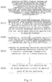
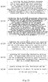
- Fig.1 shows a satellite positioning system according to an embodiment of the present invention.
- the satellite positioning system includes navigation satellites, a base station, an observation station, and may also include a receiver.
- the observation station includes a monitoring terminal and a correction parameters information generating apparatus.
- the monitoring terminal receives the observation data transmitted from the navigation satellites, and the correction parameters information generating apparatus generates correction parameters based on the received observation data, then these correction parameters are transmitted by the monitoring terminal to the base station.
- the correction parameters information generating apparatus first performs preprocessing, precise orbit determination and time synchronization processing on the satellite observation data, then calculates one or more of the following parameters: the ionosphere correction, the real-time clock difference correction, the real-time orbit correction, the partition comprehensive correction, etc. according to specific requirements.
- the correction parameters generated by the correction parameters information generating apparatus at the observation station are transmitted by the observation station monitoring terminal to the base station.
- a switch and an apparatus for superimposing, encoding, and broadcasting of message parameters are provided at the base station.
- the switch receives the basic navigation message from the satellites
- the apparatus for superimposing, encoding and broadcasting of message parameters encodes the correction parameters for enhancement into the basic navigation message through protocol superimposition to realize the integration of the message, and set the broadcasting.
- the apparatus for superimposing, encoding and broadcasting of message parameters may also set the broadcast frequencies of the correction parameters, select the link for the message broadcasting, set the broadcast format and the broadcast strategy of the message, verify the message broadcast performance, and transmit the data message to be injected to the satellite in the uplink to the switch.
- the switch of the satellite base station transmits the integrated-coded message to the satellite via the uplink injection link, with the satellite being a satellite (i.e., a navigation satellite) for providing navigation and positioning which may belong to different satellite navigation systems, for example, may be a GPS satellite, a Beidou satellite, or the like.
- a satellite i.e., a navigation satellite
- the switch of the satellite base station transmits the integrated-coded message to the satellite via the uplink injection link, with the satellite being a satellite (i.e., a navigation satellite) for providing navigation and positioning which may belong to different satellite navigation systems, for example, may be a GPS satellite, a Beidou satellite, or the like.
- the navigation satellite broadcasts the integrated satellite navigation message, that it receives from the base station, in which the correction parameters is added, and it can be received by the receiver.
- the receiver includes a receiving-end message processing apparatus which decodes the integrated satellite navigation message received by the receiver, decodes correction parameters for enhancement therefrom, and constructs observations, performs parameter correction (embodiments of the present invention have no limitation on the order of constructing observations and performing parameter correction), the positioning solution, etc., to obtain the positioning information based on the correction parameters, and may also perform the accuracy evaluation.
- correction parameters information generating apparatus which may generate correction parameters such as an ionosphere correction, a real-time clock difference correction, a real-time orbit correction, and a partition comprehensive correction, to enhance the satellite navigation (positioning) accuracy, then multiple parameters therein are superimposed at the base station.
- a model of a correction parameters is first established and a correction parameters is generated based on the model.
- the correction parameters can be realized through being broadcast only by a navigation satellite, but the correction parameters may also be broadcast through a ground-based network.
- the satellite orbit in the basic navigation message generally needs to be forecasted for 1 ⁇ 2 hours, and its forecast error will increase over time.
- the satellite orbit correction parameters is to make use of the observation data of the ground observation station network and resolve the error of the satellite orbit forecast in real time so as to correct the satellite orbit in the basic navigation message in real time, it may include satellite identifiers, satellite orbit corrections and the equivalent distance error status identifiers of the satellite orbit corrections.
- a model may be established as follows:
- dx,dy,dz,d ⁇ ,d ⁇ ,d ⁇ each represents the corrections and the rates of change of the three-dimensional vector value XYZ of the satellite orbit correction, and the superscript indicates whether the satellite is a GPS or BDS satellite, the subscript is a satellite number.
- the satellite orbit correction may be calculated by using different methods.
- satellite orbit corrections represent an orbit normal error correction, an orbit radial error correction and an orbit tangential error correction in different viewing directions.
- the satellite orbit correction (correction value) may be comprehensively resolved by using a pseudorange observation value and a carrier-phase observation value.
- the satellite clock difference correction is to make use of the observation data of the ground observation station network and resolve the error of the satellite clock difference forecast in real time so as to correct the satellite clock difference parameters in the basic navigation message in real time, it may include satellite identifiers, satellite clock difference corrections, the satellite clock difference correction truncation errors and the satellite differential equivalent distance error status identifiers.
- a model may be established as follows:
- the satellite clock difference correction dt ti indicates the comprehensive influence of the satellite ephemeris error and the satellite star clock error on the user distance error for the i-th satellite, and is used to correct the comprehensive error of the satellite ephemeris and the satellite clock difference in the navigation message.
- the satellite clock difference correction residue dt resi may be further calculated and used.
- the satellite clock difference correction residue represents the part of the i-th satellite star clock difference correction that below 0.1 m, and is used to correct the error of the satellite clock difference correction below 0.1 m, thereby the performance of the parameters is further improved and spatial signals are accurately corrected.
- the basic navigation message provides model parameters for ionosphere delay correction, but it is a function that fits the measured results into 8 or 14 parameters, resulting in the loss of accuracy, and generally its update frequency is low and the forecast time is long.
- the ionosphere correction is suitable for the correction of the real-time ionosphere delay.
- the ionosphere correction is a function of the ionosphere delay with the latitude and the longitude of the pierce point being b and 1 respectively. Further, the ionosphere delay function with the latitude and the longitude of the pierce point being (b, 1) can be regarded as the bilinear difference of ionosphere delays off our adjacent grid points.
- the environment segment area comprehensive correction is mainly used to correct the orbit clock difference residual error and the common residual error of the space environment segment error in the area.
- the partition comprehensive correction parameters according to the embodiment of the present invention is further improved on the basis of the environment segment area comprehensive correction parameters (including troposphere and space segment compensation). Due to the high-accuracy orbit correction, clock difference correction and ionosphere correction, and correction of the troposphere empirical model, the rest of the error is relatively stable. Therefore, the partition setting is added, that is, partition is performed according to the observation areas, one correction is designed per area (region) and per satellite, so as to form a partition comprehensive correction parameters model to further improve the effect of the error improvement.
- the design of the partition comprehensive correction is based on the assumption that within a certain distance, the errors of the user (receiver) on the satellite side and the propagation path are relevant. Therefore, the observation area may be divided into multiple partitions (regions), the partition comprehensive correction is obtained by integrating the first result calculated in real time using the observation data from observation stations in each partition with the first result from observation stations in one partition, and is broadcast to the user in real time, thus realizing real-time high-accuracy positioning of the navigation user.
- the first result may include a carrier-phase observation residual.
- the above correction parameters generated by the correction parameters information generating apparatus at the observation station side are transported to the apparatus for superimposing, encoding and broadcasting of message parameters at the base station side.
- the apparatus for superimposing, encoding and broadcasting of message parameters superimposes one or more of these correction parameters with the basic navigation message as needed by way of protocol superimposition.
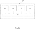
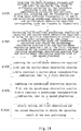
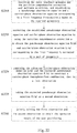
- Fig.1A schematically shows the structure of a correction parameters information generating apparatus 100.
- the correction parameters information generating apparatus 100 includes an orbit correction generation unit 101, a clock difference correction generation unit 102, an ionosphere correction generation unit 103, a partition comprehensive correction generation unit 104 and a correction parameters output unit 105.
- the orbit correction generation unit 101, the clock difference correction generation unit 102, the ionosphere correction generation unit 103 and the partition comprehensive correction generation unit 104 respectively generate an orbit correction, a clock difference correction, an ionosphere correction and a partition comprehensive correction as needed, the generated correction parameters are input to the correction parameters output unit 105, and the correction parameters output unit 105 outputs these correction parameters to the base station as needed for performing subsequent processes such as protocol superimposition, encoding, broadcasting and the like.
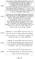
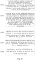
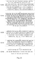
- Fig.2 schematically shows the flow of protocol superimposition.
- A1 represents the superimposed orbit correction x 1
- A2 represents the superimposed clock difference correction x 2
- A3 represents the superimposed ionosphere correction x 3
- A4 represents the superimposed partition comprehensive correction x 4 .
- the protocol superimposition can be a combination of multiple superimpositions of different correction parameters, for example:
- the partition comprehensive correction x 4 includes, but is not limited to, at least one of a Beidou partition comprehensive correction or a GPS partition comprehensive correction;
- the ionospheric correction x 3 uses models including, but being not limited to, a grid ionosphere model, an 8-parameter model or a 14-parameter model, etc., preferably uses the grid ionosphere model; 2.
- the orbit correction is also called the satellite orbit correction
- the clock difference correction is also called the satellite clock difference correction, which will no longer be described throughout the description; 3.
- the way of iteration or the way of iterative calculation mentioned in the embodiment of the present invention is only an example and not a limitation, and in other embodiments, a numerical calculation method such as recursion may be used, and a calculation method such as integration may further be used, on which the embodiment of the present invention does not impose any limitation, and in actual practice, those skilled in the art can reasonably make a choice as needed.
- correction parameters for example, including an orbit correction, a clock difference correction, an ionosphere correction, or a partition comprehensive correction (including a troposphere correction, a space segment correction and an environment segment correction)
- correction parameters can provide multiple types of user error correction modes such as DGNSS1 (clock difference correction), DGNSS2 (orbit correction, clock difference correction), DGNSS3 (orbit correction, clock difference correction, ionosphere correction), D+PPGNSS1 (clock difference correction, comprehensive correction or partition comprehensive correction), D+PPGNSS2 (orbit correction, clock difference correction, comprehensive correction or partition comprehensive correction), D+PPGNSS3 (orbit correction, clock difference correction, ionosphere correction, comprehensive correction or partition comprehensive correction),D+PPGNSS3 (clock difference correction, comprehensive correction or partition comprehensive correction), including single-frequency, dual-frequency, tri-frequency receiver positioning, and including, but not limited to, GNSS single Beidou, single GPS and Beid
- the apparatus for superimposing, encoding and broadcasting of message parameters further set the broadcast frequencies and the broadcast strategies of respective parameters based on, on one hand, the consideration of the resource limitation of the message and the resource limitation of the satellite communication link Additionally, on the other hand, the consideration of the accuracy attenuations in respective update periods of respective correction parameters.
- the GPS partition comprehensive correction ( ⁇ TGij) is the same as the partition comprehensive correction ( ⁇ Tij) in terms of definition and usage.
- the partition comprehensive correction ⁇ TGij of each satellite in each area indicates the comprehensive correction value of the j-th GPS satellite in the i-th area at an epoch time.
- the area identifier (AREAI) indicates the area where the broadcast partition comprehensive correction is located.
- the number of area identifiers broadcast by the system corresponds to the defined integer number of partitions. When the corresponding information bit is "1", it indicates that the corresponding partition comprehensive correction parameters is broadcast; when it is "0", it indicates that broadcasting is not performed.
- Each satellite broadcasts partition comprehensive corrections of a certain number of partitions.
- the correspondence between the specific satellite code and the broadcast partition code can use the typical broadcast strategy shown in the following table.
- the execution of superimposition of correction parameters is not limited thereto, and the user perform identification according to identification bits.
- the satellite identifier indicates the satellite corresponding to the broadcast satellite orbit correction and partition comprehensive correction.
- the system broadcasts a total of 63 bits of satellite identifiers, corresponding to 63 Beidou satellites. When the corresponding information bit is "1", it indicates that the correction parameters of the corresponding satellite is broadcast; when it is "0", it indicates that broadcasting is not performed.
- the user may decide to perform the positioning resolution using the correction parameters of a certain satellite in a certain area based on the above-mentioned auxiliary information such as area identifiers, satellite identifiers and the like.
- the GPS area identifier indicates the area where the broadcast GPS partition comprehensive correction is located.
- the definition of area identifiers broadcast by the system corresponds to the defined integer number of partitions. When the corresponding information bit is "1", it indicates that the corresponding partition comprehensive correction parameters is broadcast; when it is "0", it indicates that broadcasting is not performed.
- the GPS satellite identifier indicates the satellite corresponding to the broadcast GPS partition comprehensive correction.
- the system broadcasts a total of 36bits of satellite identifiers, corresponding to 36 GPS satellites. When the corresponding information bit is "1", it indicates that the correction parameters of the corresponding satellite is broadcast; when it is "0", it indicates that broadcasting is not performed.
- the broadcast quantity of correction parameters can be controlled to be less than 100bps on average, so that broadcasting of correction parameters can be implemented in the 250-500bps navigation message.
- Higher or lower broadcast frequencies of parameters may also be used, thus reducing the initialization time, or controlling the acceptable initial usage time extension.
- the broadcast frequencies thereof cannot be too high.
- the broadcast frequency being low will cause the loss of accuracy of corrections.
- the accuracy of user positioning and the broadcast efficiency of the system are compared under different broadcast frequencies, thereby determining the appropriate broadcast frequency of the correction parameters, and the smooth control is performed in combination with the different fast or slow broadcast frequencies of the correction parameters.
- fast speed, fast frequency and high accuracy can all be achieved.
- the broadcast frequencies of the parameters can be designed as: the orbit correction parameters being 3 ⁇ 6 minutes; the clock difference correction parameters being 18 seconds ⁇ 2 minutes; the ionosphere correction parameters being 3 ⁇ 6 minutes; the comprehensive correction parameters or the partition comprehensive correction parameters being 30 ⁇ 180 seconds.
- the specific broadcast frequencies selected according to the performance requirements may be as follows: the orbit correction is of the frequency of 6 minutes; the error of the clock difference correction within the frequency of 2 minutes can be controlled at 0.2 meters; and the error of the partition correction of the frequency of 3 minutes can be controlled at about 0.06 meters, as the meanings of the numbers in the above table.
- the broadcast strategy only has to ensure that a predetermined accuracy can obtain within this range when it is broadcast to the user for reception and use.
- the accuracies of respective correction parameters are reduced within their respective update periods: therefore, if the frequency of the clock difference correction is within 2 minutes and the frequency of the partition correction is within 3 minutes, the performance can be guaranteed. Generally, the higher the broadcast frequency, the better the performance. Typical values are like that the orbit correction is of frequency of 6 minutes, the clock difference correction is of frequency of 18 seconds, and the partition correction is of frequency of 36 seconds.
- the processing time is basically matched, and the user's use area is large, so as to achieve wide-area differential performance improvement.
- protocol superimposition is the superimposition of correction parameters, for example, example (1) - example (7) are also various superimposition combinations of different correction parameters). Details are as follows.
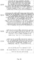
- Fig.3A is a timing matching schematic diagram of superimposing an orbit correction and a partition comprehensive correction on the basis of a basic navigation message, corresponding to the above example (3).
- the update period of the orbit correction is m minutes, where m is a positive number and 3 ⁇ m ⁇ 6.
- the time m' is the update time point of the last orbit correction; within the period of time between the current broadcast ephemeris update time t0 and the next broadcast ephemeris update time t1: the time t0+b1 is the update time point of one partition comprehensive correction, the time t0+b2 is the update time point of another partition comprehensive correction, and the time m'+m is the update time point of the first orbit correction (one valid period of time is from m' to m'+m, the next valid period of time is from m'+m to m'+2m, and so on, which will no longer be described), the time m'+2m is the update time point of the second orbit correction, where b1 and b2 are both positive numbers, and t0+b1 ⁇ m'+m ⁇ t0+b2 ⁇ m'+2m; specific examples are as follows
- superimposing the orbit correction and the partition comprehensive correction on the basis of the basic navigation message corresponding to the above example (3) comprises: 1. based on the basic navigation message generated at the previous broadcast ephemeris update time t, solving the orbit correction at the time m' through the above equation (c); 2. based on the basic navigation message generated at the current broadcast ephemeris update time t0 and the orbit correction at time m' obtained by solution, solving the partition comprehensive correction through the above equation (g).
- superimposing the orbit correction and the partition comprehensive correction on the basis of the basic navigation message corresponding to the above example (3) comprises: 1. based on the basic navigation message generated at the current broadcast ephemeris update time t0, solving the orbit correction at the time m'+m through the above equation (c); 2. based on the basic navigation message generated at the current broadcast ephemeris update time t0 and the orbit correction at the time m'+m obtained by solution, solving the partition comprehensive correction through the above equation (g).
- Fig.3B is a timing matching schematic diagram of superimposing a clock difference correction and a partition comprehensive correction on the basis of a basic navigation message, corresponding to the above example (1).
- the update frequency of the partition comprehensive correction is faster than the update frequency of the clock difference correction.
- the update period of the clock difference correction is a minutes, where a is a positive number and 0.3 ⁇ a ⁇ 2.
- the time a' is the update time point of the last clock difference correction; within the period of time between the current broadcast ephemeris update time t0 and the next broadcast ephemeris update time t1: the time t0+b1 is the update time point of one partition comprehensive correction, the time t0+b2 is the update time point of another partition comprehensive correction, the time a'+a is the update time point of the first clock difference correction (one valid period of time is from a' to a'+a, the next valid period of time is from a'+a to a'+2a and so on, which will no longer be described), the time a'+2a is the update time point of the second clock difference correction, wherein b1 and b2 are both positive numbers, and t0+b1 ⁇ a'+a ⁇ t0+b2 ⁇ a'+2a. Specific examples are
- superimposing the orbit correction and the partition comprehensive correction on the basis of the basic navigation message corresponding to the above example (1) comprises: 1. based on the basic navigation message generated at the previous broadcast ephemeris update time t, solving the clock difference correction at time a' through the above equation (a); 2. based on the basic navigation message generated at the current broadcast ephemeris update time t0 and the clock difference correction at the time a' obtained by solution, solving the partition comprehensive correction through the above equation (b).
- superimposing the clock difference correction and the partition comprehensive correction on the basis of the basic navigation message corresponding to the above example (1) comprises: 1. based on the basic navigation message generated at the current broadcast ephemeris update time t0, solving the clock difference correction at the time a'+a through the above equation (a); 2. based on the basic navigation message generated at the current broadcast ephemeris update time t0 and the clock difference correction at the time a'+a obtained by solution, solving the partition comprehensive correction through the above equation (b).
- Fig.3C is another timing matching schematic diagram of superimposing a clock difference correction and a partition comprehensive correction on the basis of a basic navigation message, corresponding to the above example (1).
- the update period of the clock difference correction is a minutes, where a is a positive number and 0.3 ⁇ a ⁇ 2.
- the time a' is the update time point of the last clock difference correction
- the time t0+d is the update time point of one partition comprehensive correction, and meantime a'+(n)*a ⁇ t0+d ⁇ a'+(n+1)*a is met, where d is a positive number and n is a positive integer.
- superimposing the clock difference correction and the partition comprehensive correction on the basis of the basic navigation message corresponding to the above example (1) comprises: at first, based on the basic navigation message generated at the current broadcast ephemeris update time t0, solving the clock difference correction at time a'+(n)*a through the above equation (a); then, based on the basic navigation message generated at the current broadcast ephemeris update time t0 and the clock difference correction at the time a'+(n)*a obtained by solution, solving the partition comprehensive correction through the above equation (b).
- time identifiers such as the time t0+b1 and the time a'+a for the identification shown in Fig.3C are all used to only describe the embodiment, but not the actual time identifiers, and the length of the identification in Fig.3B does not represent the actual length of the identification.
- the update frequency of the partition comprehensive correction is faster than the update frequency of the clock difference correction, and the update frequency of the clock difference correction is faster than the update frequency of the orbit correction, as shown in Fig.3D.
- Fig.3D is a timing matching schematic diagram of superimposing an orbit correction, a clock difference correction and a partition comprehensive correction on the basis of a basic navigation message corresponding to the above example (2).
- the update period of the orbit correction is m minutes
- the update period of the clock difference correction is a minutes, where m and a are positive numbers, and 3 ⁇ m ⁇ 6, 0.3 ⁇ a ⁇ 2, a ⁇ m.
- the time m' is the update time point of the last orbit correction
- the time a' is the update time point of the last clock difference correction
- the time t0+b1 is the update time point of one partition comprehensive correction
- the time t0+b2 is the update time point of another partition comprehensive correction
- the time t0+b3 is the update time point of yet another partition comprehensive correction
- the time m'+m is the update time point of the first orbit correction
- the time a'+a is the update time of the first clock difference correction
- superimposing the orbit correction, the clock difference correction and the partition comprehensive correction on the basis of the basic navigation message corresponding to the above example (2) comprises: 1. based on the basic navigation message generated at the previous broadcast ephemeris update time t, solving the orbit correction at the time m' is through the above equation (c); 2. based on the basic navigation message generated the previous broadcast ephemeris update time t and the orbit correction at the time m' obtained by solution, solving the clock difference correction at the time a' through the above equation (d); 3. based on the basic navigation message generated at the current broadcast ephemeris update time t0 and the orbit correction at the time m' obtained by solution, solving the partition comprehensive correction through the above equation (e);
- superimposing the orbit correction, the clock difference correction and the partition comprehensive correction on the basis of the basic navigation message corresponding to the above example (2) comprises: 1. based on the basic navigation message generated at the previous broadcast ephemeris update time t, solving the orbit correction at the time m' through the above equation (c); 2. based on the basic navigation message generated at the current broadcast ephemeris update time t0 and the orbit correction at the time m' obtained by solution, solving the clock difference correction at the time a'+(h)*a through the above equation (d); 3.
- superimposing the orbit correction, the clock difference correction and the partition comprehensive correction on the basis of the basic navigation message corresponding to the above example (2) comprises: 1. based on the basic navigation message generated at the current broadcast ephemeris update time t0, solving the orbit correction at the time m'+(e)*m through the above equation (c); 2. based on the basic navigation message generated at the current broadcast ephemeris update time t0 and the orbit correction at the time m'+(e)*m obtained by solution, solving the clock difference correction at the time a'+(f)*a through the above equation (d); 3.
- the update frequency of the clock difference correction is faster than the update frequency of the partition comprehensive correction
- the update frequency of the partition comprehensive correction is faster than the update frequency of the orbit correction.
- Fig.3E is another timing matching schematic diagram of superimposing an orbit correction, a clock difference correction and a partition comprehensive correction on the basis of a basic navigation message, corresponding to the above example (2).
- the update period of the orbit correction is m minutes
- the update period of the clock difference correction is a minutes, where m and a are positive numbers, and 3 ⁇ m ⁇ 6, 0.3 ⁇ a ⁇ 2.
- the time m' is the update time point of the last orbit correction
- the time a' is the update time point of the last clock difference correction
- the time t0+b1 is the update time point of one partition comprehensive correction
- the time t0+b2 is the update time point of another partition comprehensive correction
- superimposing the orbit correction, the clock difference correction and the partition comprehensive correction on the basis of the basic navigation message corresponding to the above example (2) comprises: at first, based on the basic navigation message generated at the previous broadcast ephemeris update time t, solving the orbit correction at the time m' through the above equation (c); then, based on the basic navigation message generated at the current broadcast ephemeris update time t0 and the orbit correction at the time m' obtained by solution, solving the clock difference correction at time a'+h*a through the above equation (d), and finally, based on basic navigation message generated at the current navigation ephemeris update time t0 and the orbit correction at the time m' and the clock difference correction at the time a'+h*a obtained by solution, solving the partition comprehensive correction through the above equation (e);
- superimposing the orbit correction, the clock difference correction and the partition comprehensive correction on the basis of the basic navigation message corresponding to the above example (2) comprises: at first, based on the basic navigation message generated at the current broadcast ephemeris update time t0, solving the orbit correction at the time m'+(e)*m through the above equation (c); then, based on the basic navigation message generated at the current broadcast ephemeris update time t0 and the orbit correction at the time m'+(e)*m obtained by solution, solving the clock difference correction at the time a'+(f)*a through the above equation (d), and finally, based on the basic navigation message generated at the current broadcast ephemeris update time t0 and the orbit correction at time m'+(e)*m and the clock correction at time a'+(f)*a obtained by solution, solving the partition comprehensive correction through the above equation (e).
- the update period can be, for example, 3 ⁇ 6 minutes.
- the ionosphere correction is the correction for the propagation segment (or environment segment) error.
- multiple observation stations obtain the ionosphere delay amount by using pseudorange observation values (the pseudorange observation value may be the original pseudorange observation value P, or may be the pseudorange observation value P(x) corrected by the correction parameters, which is not limited by the embodiment of the present invention)of multiple frequency points within a certain period of time, and generates an ionosphere grid model or an 8-parameter model or a 14-parameter model by modeling to obtain an ionosphere correction x 3 ( b , l ). Therefore, there is no need to perform the timing matching for the ionosphere correction.
- superimposing the orbit correction, the ionosphere correction and the partition comprehensive correction on the basis of the basic navigation message corresponding to the above example (5) comprises: 2. based on the basic navigation message generated at the current broadcast ephemeris update time t0 and the orbit correction at the time m' obtained by solution, solving the ionosphere correction through the above equation (i); 3. based on the basic navigation message generated at the current broadcast ephemeris update time t0 and the orbit correction at the time m' obtained by solution and the ionosphere correction, solving the partition comprehensive correction through the above equation (j).
- superimposing the orbit correction, the ionosphere correction and the partition comprehensive correction on the basis of the basic navigation message corresponding to the above example (5) comprises: 2. based on the basic navigation message generated at the current broadcast ephemeris update time t0 and the orbit correction at the time m'+m obtained by solution, solving the ionosphere correction through the above equation (i); 3. based on the basic navigation message generated at the current broadcast ephemeris update time t0 and the orbit correction at the time m'+m obtained by solution and the ionosphere correction, solving the partition comprehensive correction through the above equation (j).
- superimposing the orbit correction, the ionosphere correction and the partition comprehensive correction on the basis of the basic navigation message corresponding to the above example (6) comprises: 2. based on the basic navigation message generated at the current broadcast ephemeris update time t0 and the clock difference correction at time a'+a obtained by solution, solving the ionosphere correction through the above equation (k); 3. based on the basic navigation message generated at the current broadcast ephemeris update time t0 and the clock difference correction at time a'+a obtained by solution and the ionosphere correction, solving the partition comprehensive correction through the above equation (m).
- superimposing the orbit correction, the clock difference correction, the ionosphere correction and the partition comprehensive correction on the basis of the basic navigation message corresponding to the above example (7) comprises: 3. then, based on the basic navigation message generated at the current broadcast ephemeris update time t0 and the orbit correction at the time m' and the clock difference correction at the time a'+h*a obtained by solution, solving the ionosphere correction through the above equation (n); 4.
- superimposing the orbit correction, the clock difference correction, the ionosphere correction and the partition comprehensive correction on the basis of the basic navigation message corresponding to the above example (7) comprises: 3. then, based on the basic navigation message generated at the current broadcast ephemeris update time t0 and the orbit correction at the time m'+(e)*m and the clock difference correction at the time a'+(f)*a obtained by solution, solving the ionosphere correction through the above equation (n); 4.
- superimposing the orbit correction, the clock difference correction, the ionosphere correction and the partition comprehensive correction on the basis of the basic navigation message corresponding to the above example (7) comprises: then, based on the basic navigation message generated at the current broadcast ephemeris update time t0 and the orbit correction at the time m'+(e)*m and the clock difference correction at the time a'+(f)*a obtained by solution, solving the ionosphere correction by the above equation (n);and finally, based on the basic navigation message generated at the current broadcast ephemeris update time t0 and the orbit correction at the time m'+(e)*m and the clock difference correction at the time a'+(f)*a and the ionosphere correction, solving the partition comprehensive correction through the above equation (y).
- the user end when receiving and/or using the correction parameters, the user end (receiver) needs to perform matching with the received correction parameters (including, but not limited to, matching in time and matching on the type of correction parameters).
- the partition comprehensive correction is the comprehensive correction of a satellite currently observed in each partition. Limited by the satellite-earth interface resources, and considering the impact of the update frequency of the partition comprehensive correction on the performance, when the update time is less than 2 minutes, there is no significant difference in the accuracy of user positioning; after the update time exceeds 2 minutes, the accuracy of positioning drops significantly.
- the embodiments of the present invention describe a procedure and a method of correction parameters superimposition, and a matching procedure between them.
- multiple superimposition combinations of different correction parameters may enable the user to achieve positioning requirements of different levels of accuracy under different hardware and software environments. For example, after the protocol superimposes the partition comprehensive correction, the positioning requirement of decimeter-accuracy can be realized.
- the satellite navigation system proposed by the present invention must consider the method and strategy of parameter arrangement.
- the message arrangement of the correction parameters needs to consider the following factors:
- the present invention also provides a message arrangement and broadcast method for an enhanced parameter in a satellite navigation system, which can fully utilize the remaining resources in the navigation message of the satellite navigation system, Additionally, in accordance with the repetition periods of respective pages, superframes, main frames and sub-frames of the remaining resources, arrange the different correction parameters according to their respective characteristics to be integrated with the navigation message and broadcast to the user.
- the message arrangement and broadcast method can be implemented by the above apparatus for superimposing, encoding and broadcasting of message parameters set at the base station, where the enhanced parameter is the correction parameters, and will no longer be described throughout the description.
- the message broadcast apparatus 40 shown in Fig.4 may implement functions of message encoding (arrangement) and broadcast setting of the above apparatus for superimposing, encoding and broadcasting of message parameters, and the message broadcast apparatus 40 may also include a transmitter to implement the function of transmitting a signal by the switch of the base station to satellites.
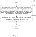
- Fig.4 shows a block diagram of the configuration of main units of a message broadcast apparatus 40 for an enhanced parameter in a satellite navigation system according to an embodiment of the present invention.
- the message broadcast apparatus 40 include a processor 401 and a transmitter 402.
- the processor 401 determines an insertion position of the enhanced parameter in a reserved space in a navigation message frame structure model according to the byte size and the broadcast frequency of the enhanced parameter that needs to be broadcast, so as to perform the message arrangement of the enhanced parameter.
- the transmitter 402 uploads the arranged message to a broadcast satellite for broadcasting the message.
- the navigation message frame structure model is defined by a superframe, a main frame and a sub-frame,with each of superframes containing 120 main frames, each of main frames containing 5 sub-frames, each of sub-frames containing 10 words and each of words containing 30 bits and lasting 0.06 second.
- sub-frame 1 is used to broadcast the present satellite's basic navigation information of the satellite navigation system, and information in a group of sub-frames 1 is transmitted by 10 pages in a time division manner, that is, one transmission of the present satellite's basic navigation information is accomplished by 10 pages composed of 10 sub-frames 1 (that is, a group of sub-frames 1 constitutes a group of pages); sub-frame 2 to sub-frame 4 are used to broadcast the integrity and differential information of the satellite navigation system, and information in respective groups of sub-frames 2 ⁇ 4 is transmitted by 6 pages respectively in a time division manner, that is, the transmission of the integrity and differential information of the satellite navigation system at one time is accomplished respectively by 6 pages composed of 6 sub-frames 2 ⁇ 4 (that is, a group of sub-frames 2 ⁇ 4 constitutes a group of pages respectively); and sub-frame 5 is used to broadcast all the satellite almanacs, ionosphere information and time synchronization information with other systems of the satellite navigation system, and information in
- a satellite-based enhanced parameter is for improving the accuracy of the system's real-time service, and it differentiates the main error sources such as satellite orbit error, satellite clock difference and ionosphere delay, and establishes a model for each type of error source for correcting errors of these parameters in the basic navigation.
- the satellite-based enhanced parameter may include satellite clock difference correction parameters, satellite orbit correction parameters, ionosphere correction parameters and partition comprehensive correction parameters, which will be described in detail hereinafter.
- the above-described satellite-based enhanced parameter is merely one example of an enhanced parameter for ease of explanation, rather than limiting the present invention thereto.
- the invention can also be applied to ground-based enhanced parameters.
- Fig.5 is a schematic diagram illustrating a navigation message frame structure model according to an embodiment of the present invention.
- the navigation message frame structure is defined by a superframe, a main frame and a sub-frame.
- Each of superframes is 180000 bits and lasts 6 minutes.
- Each of superframes includes 120 main frames, as shown by main frame 1, main frame 2 ... main frame n ... main frame 120 in Fig.5 .
- Each of main frames is 1500 bits and lasts 3 seconds.
- Each of main frames includes 5 sub-frames, as shown by sub-frame 1, sub-frame 2, sub-frame 3, sub-frame 4 and sub-frame 5 in Fig.5 .
- Each of sub-frames is 300 bits and lasts 0.6 seconds.
- Each of sub-frames further includes 10 words, as shown by word 1, word 2, ..., word 10 in Fig.5 .
- Each of words is 30 bits and lasts 0.06 seconds.
- Each of words includes two portions, i.e., navigation message information (or data) and a check code. No error-correction coding is performed on the first 15 bits of the first word (i.e., word 1) of each sub-frame, and the last 11 bits of the information are error-corrected by employing the BCH (15,11,1) manner.
- word 1 contains 26-bit information bits and a 4-bit check code.
- the other 9 words (i.e., words 2 ⁇ 10) of each sub-frame are error-correction coded by employing the BCH(15,11,1) plus interleaving manner.
- each of words 2 ⁇ 10 contains 22-bit information bits and an8-bit check code.
- Fig.6 is a schematic diagram illustrating navigation message information contents in a navigation message frame structure model according to an embodiment of the present invention.
- the navigation message includes the present satellite's basic navigation information, all the satellite almanacs, the time synchronization information with other systems, the integrity and differential information of the Beidou system and ionosphere information.
- sub-frame 1 is used to broadcast the present satellite's basic navigation information
- sub-frames 2 ⁇ 4 are used to broadcast the integrity and differential information of the Beidou system
- sub-frame 5 is used to broadcast all the satellite almanacs, the ionosphere information and the time synchronization information with other systems.
- completing one transmission of the present satellite's basic navigation information requires a group of pages of sub-frame 1 to broadcast, in which a group of pages of sub-frame 1 consists of 10 pages (that is, transmitted in a time division manner), that is, one transmission of the present satellite's basic navigation information is completed by ten continuous sub-frames 1 in the time domain.
- Completing one transmission of the integrity and differential information of the Beidou system requires a group of pages of sub-frames 2 ⁇ 4 to broadcast, in which a group of pages of sub-frames 2 ⁇ 4 consists of 6 pages (that is, transmitted in a time division manner) respectively, that is, one transmission of the integrity and differential information of the Beidou system is completed by 6 consecutive sub-frames 2 ⁇ 4 in the time domain respectively.
- a group of pages of sub-frame 5 consists of 120 pages (that is, transmitted in a time division manner), that is, one transmission of all the satellite almanacs, the ionosphere information and the time synchronization information with other systems is completed by continuous 120 sub-frames 5 in the time domain.
- FIG.7 is a schematic diagram illustrating an arrangement relationship in time of pages of a sub-frame in a navigation message frame structure model according to an embodiment of the present invention.
- main frames each including 5 sub-frames are sequentially broadcast. That is to say, after sub-frame 1, sub-frame 2, sub-frame 3, sub-frame 4 and sub-frame 5 of the first main frame are broadcast in sequence, the followed is sub-frame 1, sub-frame 2, sub-frame 3, sub-frame 4 and sub-frame 5 of the second main frame, and so on. It can be seen that the repetition period of the same sub-frame is equivalent to the length of one main frame, that is, 3 seconds.
- sub-frame 2 of the first main frame is page 1 of sub-frame 2
- sub-frame 2 of the second main frame is page 2 of sub-frame 2
- sub-frame 2 of the third main frame is page 3 of sub-frame 2
- sub-frame 2 of the fourth main frame is page 4 of sub-frame 2
- sub-frame 2 of the fifth main frame is page 5 of sub-frame 2
- sub-frame 2 of the sixth main frame is page 6 of sub-frame 2. That is to say, sub-frames 2 of the six main frames consecutive in time constitute 6 pages of sub-frame 2, and the message information broadcast by these 6 pages (that is, 6 sub-frames 2) is different between each other.
- the broadcast frequency (that is, update frequency) of the message information broadcast by the 6 pages of sub-frame 2 is 18 seconds.
- sub-frames 2 of the seventh to twelfth main frames may constitute 6 pages of the next group (that is, the next update period) of sub-frame 2 for broadcasting the updated message information.
- unused information bits are usually reserved.
- the lower 150 bits of pages 1 ⁇ 10 of sub-frame 1, pages 1 ⁇ 6 of sub-frame 4 and pages 14 ⁇ 34, pages 74 ⁇ 94,pages 103 ⁇ 120 of sub-frame 5 are reserved information bits.
- sub-frame 3 sub-frame 4 and pages 117 ⁇ 120 of sub-frame 5 are reserved information bits (that is, free resource bits). Therefore, satellite-level enhanced parameters can be further broadcast by using these reserved information bits.
- the message information broadcast by sub-frame 3 and sub-frame 4 can implement an update period of 3 seconds and an integral multiple thereof while the message information broadcast by sub-frame 5 may implement an update period of6minutes. Therefore, the processor 401 may determine into which reserved information bit in which page of which sub-frame the enhanced parameter is inserted to be broadcast according to the byte size and the broadcast frequency of the enhanced parameter (e.g., a satellite-based enhanced parameter) that needs to be broadcast. For example, according to the use requirement of the satellite clock difference correction, its update period is 18 seconds.
- the satellite clock difference correction can be inserted into reserved information bits of sub-frame 2/3 to be broadcast, so as to achieve the broadcast frequency of 18 seconds.
- the update period of the satellite orbit correction is 6 minutes, thus it can be inserted into reserved information bits of sub-frame 5 to be broadcast, so as to achieve the broadcast frequency of 6minutes.
- the transmitter 402 may upload the arranged message to a broadcast satellite (e.g., the I-branch of the GEO satellite)for broadcasting the message.
- a broadcast satellite e.g., the I-branch of the GEO satellite
- a user terminal can receive the broadcast message, thus obtain the enhanced parameter so as to correct the error in the basic navigation information to improve the navigation accuracy.
- navigation message frame structure model given in Fig.5 and Fig.6 takes the Beidou system as an example, the present invention is not limited thereto, and those skilled in the art can employ the navigation message frame structure model of any other suitable navigation system.
- the message broadcast apparatus 40 for the enhanced parameter in the satellite navigation system by making the basic navigation information and enhanced information be uniformly broadcast, the scalability of the navigation message is improved, the satellite-and-earth-integrated flexible broadcast of the navigation message is realized, the flexibility of message broadcasting is improved, the user performance is improved, and the utilization of channel link resources is improved.
- the processor 401 may determine the byte size and the broadcast frequency of the enhanced parameter according to a quantization range and a quantization accuracy of the enhanced parameter respectively.
- the accuracy of basic navigation satellite broadcast ephemeris is usually better than 10 meters.
- the URE User Range Error
- the range of an orbit correction may be set as a range of 3 times, that is, ⁇ 30 meters can meet the requirements. Taking into account further abnormal cases, this range can be appropriately enlarged, for example, the typical value is set to ⁇ 64 meters.
- the quantization accuracy of this parameter can be designed on the centime ters-level.
- the existing clock difference can represent ⁇ 409 meters with a quantization error of 0.1 meters.
- the clock difference correction residue is increased, and the range of the residue is ⁇ 0.0625 meters.
- the quantization accuracy can be designed on the centime ters-level.
- the partition correction is made on the basis of the correction of the clock difference.
- the calculation of the highest accuracy of positioning needs using such correction.
- the accuracy of the resolving and the parameter fitting of the clock difference is usually better than 1 nanosecond, and the accuracy of the orbit correction is also better than 2 nanoseconds. Therefore, the range of the partition correction is set at ⁇ 5 nanoseconds so as to satisfy the representation requirement of the parameter. This range can be set as ⁇ 8 nanoseconds in consideration of further abnormal cases. Other cases beyond the representation range will be uniformly classified into the clock difference parameter. Taking into account the requirement of high accuracy, the quantization unit of this parameter can be 0.0625 nanoseconds, and the truncation error at this time is 1 cm.
- Ionosphere correction parameters use models including, but being not limited to, grid ionosphere models, 8-parameter models, or 14-parameter models, and preferably use grid ionosphere models.
- the accuracy of the resolving of the grid ionosphere is about 0.5 meters and the quantization accuracy of too high is a waste for resources.
- the design for the quantization accuracy of 0.1 meter can meet the requirement.
- the maximum delay is generally no more than 50 meters, and larger delays can be marked as unavailable. Therefore, the value of this parameter can be designed in the range of tens of meters, with a typical value being 63 meters.
- the byte size and the update period of each enhanced parameter may be determined.
- the update period of the satellite clock difference correction parameters is preferably 18 seconds
- the update period of the satellite orbit correction parameters is preferably 6 minutes
- the update period of the partition comprehensive correction parameters is preferably 36 seconds
- the update period of the ionosphere correction parameter is preferably 3 minutes.
- each partition comprehensive correction occupies 8 bits of information bits
- each satellite's satellite orbit correction occupies 40 bits of information bits, and so on.
- the message arrangement scheme of each enhanced parameter in the navigation message frame structure model may be determined according to the byte size and update period of each enhanced parameter.
- the enhanced parameter may include satellite clock difference correction parameters and partition comprehensive correction parameters
- the processor 401 may insert the satellite clock difference correction parameters into a first group of predetermined positions in the reserved space of sub-frame 2 and sub-frame 3 and transmits the satellite clock difference correction parameters by 6 pages in a time division manner (that is, one broadcast of the satellite clock difference correction parameters is completed by 6 pages), and insert the partition comprehensive correction parameters into a second group of predetermined positions in the reserved space of sub-frame 2 to sub-frame 4 and transmits the partition comprehensive correction parameters by the 12 pages in a time division manner (that is, one broadcast of the partition comprehensive correction parameters is completed by 12 pages in sub-frame 2 to sub-frame 4 respectively).
- the update period of the satellite clock difference correction is 18 seconds.
- the update period of the integrity and differential information of the Beidou system broadcast by sub-frames 2 ⁇ 4 via 6 pages is also 18 seconds. Therefore, the satellite clock difference correction parameters may be inserted into certain information bits in the reserved space in sub-frames 2 ⁇ 4 to achieve the update period of 18 seconds.
- choosing to insert the satellite clock difference correction parameters into the first group of predetermined positions in the reserved space of sub-frame 2 and sub-frame 3 is only as an example, and the present invention is not limited thereto. Those skilled in the art may select other suitable reserved information bits according to the teachings of the present invention.
- the update period of the partition comprehensive correction is 36 seconds.
- the update period of the integrity and differential information of the Beidou system broadcast by sub-frames 2 ⁇ 4 via 6 pages is 18 seconds, if two groups of 6 pages(i.e., 12 pages) of sub-frames 2 ⁇ 4 are used to broadcast, an update period of 36 seconds can also be achieved.
- the partition comprehensive correction parameters may be broadcast through certain information bits in the reserved space of sub-frames 2 ⁇ 4 in the first to twelfth main frames, and thereby one broadcast of the partition comprehensive correction parameters may be achieved.
- the first group of predetermined positions and the second group of predetermined positions described herein is in order for distinguishing a set of reserved information bits for broadcasting the satellite clock difference correction parameters from a set of reserved information bits for broadcasting the partition comprehensive correction parameters.
- a part of the positions in the first group of predetermined positions coincide with a part of positions in the second group of predetermined positions, that is, the broadcasting of the satellite clock difference correction parameters and the broadcasting of the partition comprehensive correction parameters may share some reserved information bits.
- the message arrangements of the satellite clock difference correction parameters and the partition comprehensive correction parameters will be further described in detail by way of examples hereinafter.
- sub-frames 2 ⁇ 4 may not be fixed to be composed of 6 pages respectively, that is, the update period of the message broadcast may not be fixed at 18 seconds, but may be implemented as an update period of a multiple of 3 seconds. Therefore, by flexibly arranging pages of a sub-frame, the dynamic adjustment, the flexible allocation and the combination of the rapid and slow update frequencies of the message arrangement are realized, thereby saving resources.
- the enhanced parameter includes partition comprehensive correction parameters, and the partition comprehensive correction parameters include partition comprehensive corrections, area identifiers and satellite identifiers.
- the area identifiers are used for, for each of areas in the satellite navigation system, employing a 1-bit information bit respectively to identify whether there is a partition comprehensive correction that needs to be broadcast, and the processor 401 inserts the area identifiers into a third group of predetermined positions in the reserved space of page 1 of sub-frame 2.
- the satellite identifiers are used for, for each of satellites in the satellite navigation system, employing a 1-bit information bit respectively to identify whether there is a partition comprehensive correction that needs to be broadcast, and the processor 401 inserts the satellite identifiers into a fourth group of predetermined positions in the reserved space of page 2 to page 4 of sub-frame 2.
- the processor 401 inserts partition comprehensive corrections, which correspond to different areas and different satellites respectively and needs to be broadcast, into a fifth group of predetermined positions in the reserved space of page 1 to page 6 of sub-frame 3 and sub-frame 4 sequentially.
- the broadcast period of the partition comprehensive correction parameters is 30 seconds to 3 minutes, and preferably 36 seconds.
- the embodiment of the present invention takes 36 seconds as an example, but is merely an example, not a limitation.
- the satellite navigation system can be divided into multiple areas, and each of areas broadcasts one partition comprehensive correction. Limited by satellite downlink navigation signal link resources, different satellites may broadcast different partition comprehensive corrections.
- the Beidou satellite navigation system is still taken as an example for illustration by way of examples.
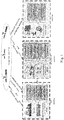
- Figs.8A to 8L are schematic diagrams respectively illustrating examples of message arrangements of pages 1 ⁇ 6 of sub-frames 2 ⁇ 4 for broadcasting partition comprehensive correction parameters according to an embodiment of the present invention. As shown on the far left of each figure, a sub-frame number and page number i are shown. The numbers above the information bit sequence indicate the bit numbers of the corresponding information bits in the page, MSB represents the most significant bit, and LSB represents the least significant bit.
- area identifiers are set to be used for, for each of 30 areas, employing a 1-bit information bit respectively to identify whether there is a partition comprehensive correction that needs to be broadcast.
- Fig.8A shows the message arrangement of page 1 of sub-frame 2.
- the 134th bit is used to broadcast the area identifier AREAI1 of area 1, and when this identification bit is "1", it indicates that there is a partition comprehensive correction that needs to be broadcast in area 1, and when this identification bit is "0", it indicates that there is no partition comprehensive correction that needs to be broadcast in area 1.
- the 135th bit is used to broadcast the area identifier AREAI2 of area 2, and when this identification bit is "1", it indicates that there is a partition comprehensive correction that needs to be broadcast in area 2, and when this identification bit is "0", it indicates that there is no partition comprehensive correction that needs to be broadcast in area 2, and so on.
- the 171th bit is used to broadcast the area identifier AREAI30 of area 30, and when this identification bit is "1", it indicates that there is a partition comprehensive correction that needs to be broadcast in area 30, and when this identification bit is "0", it indicates that there is no partition comprehensive correction that needs to be broadcast in area 30.
- "P” in the figure represents 8bits of check bits.
- the 134th bit to the 142th bit and the 151th bit to the 170th bit may correspond to the third group of predetermined positions as described above, for broadcasting the area identifiers AREI1 to AREI30 of 30 areas.
- satellite identifiers are set to be used for, for each of the 63 satellites, employing a 1-bit information bit respectively to identify whether there is a partition comprehensive correction that needs to be broadcast.
- Figs.8B to 8D show the message arrangements of pages 2 ⁇ 4 of the sub-frame 2 respectively.
- the 134th bit in page 2 of sub-frame 2 is used to broadcast the satellite identifier BDID1 of satellite 1, and when this identification bit is "1", it indicates that there is a partition comprehensive correction that needs to be broadcast for satellite 1, and when this identification bit is "0", it indicates that there is no partition comprehensive correction that needs to be broadcast for satellite 1.
- the 135th bit is used to broadcast the area identifier BDID2 of satellite 2, and when this identification bit is "1", it indicates that there is a partition comprehensive correction that needs to be broadcast for satellite 2, and when this identification bit is "0", it indicates that there is no partition comprehensive correction that needs to be broadcast for satellite 2, and so on.
- the 171st bit is used to broadcast the satellite identifier BDID30 of satellite 30, and when this identification bit is "1", it indicates that there is a partition comprehensive correction that needs to be broadcast for satellite 30, and when this identification bit is "0", it indicates that there is no partition comprehensive correction that needs to be broadcast for satellite 30.
- "P” in the figure represents 8bits of check bits. It can be understood that, here, the 134th bit to the 142th bit and the 151th bit to the 170th bit are used to broadcast the satellite identifiers BDID1 to BDID30 of the 30 satellites of satellites 1 ⁇ 30.
- Fig.8C shows the message arrangement of page 3 of sub-frame 2.
- the 134th bit to the 142th bit and the 151th bit to the 170th bit of page 3 of sub-frame 2 are used to broadcast the satellite identifiers BDID31 to BDID60 of the 30 satellites of satellites 31 ⁇ 60, details thereof is similar with those of Fig.8B and will no longer be described here.
- Fig.8D shows the message arrangement of page 4 of sub-frame 2.
- the 134th bit to 136th bit of page 4 of sub-frame 2 are used to broadcast the satellite identifiers BDID61 to BDID63 of the three satellites of satellites 61-63.
- the 137th bit to the 142th bit and the 151th bit to the 170th bit can be used to broadcast other information or remain reserved. It can be understood that, here, the 134th bits to the 142th bits and the 151th bits to the 170th bits of pages 2-3 of sub-frame 2and the 134th bit to the 136th bit of page 4 of sub-frame 2 may correspond to the fourth group of predetermined positions as described above, for broadcasting the satellite identifiers BDID1 to BDID63 of 63 satellites.
- Fig.8E shows the message arrangements of pages 5 ⁇ 6 of sub-frame 2. As shown in Fig.8E , the 134th bits to the 142th bits and the 151th bits to the 170th bits of pages 5 ⁇ 6 of sub-frame 2 are still reserved (as indicated by Rev) for future use.
- partition comprehensive corrections which correspond to different areas and different satellites respectively and needs to be broadcast, are inserted into a fifth group of predetermined positions in the reserved space of page 1 to page 6 of sub-frame 3 and sub-frame 4 sequentially.
- Fig.8F to Fig.8K respectively show the message arrangements of pages 1 ⁇ 6 of sub-frame 3.
- each partition comprehensive correction occupies 8 bits of information bits, and the 257th to 262th bits of page 1 of sub-frame 3 are used to broadcast the upper 6 bits of the first partition comprehensive correction ( ⁇ T 1 ), while the 271th bit to the 272th bit of page 1 of sub-frame 3 are used to broadcast the lower 2 bits of the first partition comprehensive correction ( ⁇ T 1 ).
- the 273th bit to the 280th bit of page 1 of sub-frame 3 are used to broadcast the second partition comprehensive correction ( ⁇ T 2 ), the 281th bit to the 288th bit of page 1 of sub-frame 3 are used to broadcast the third partition comprehensive correction ( ⁇ T 3 ), and the 289th bit to the 292th bit of page 1 of sub-frame 3 are used to broadcast the upper 4 bits of the fourth partition comprehensive correction ( ⁇ T 4 ).
- 3.5 partition comprehensive corrections can be broadcast through the 28 information bits of the 257th bit to the 262th bit and the 271th bit to the 292th bit of page 1 of sub-frame 3.
- each page of pages 2 ⁇ 6 of sub-frame 3 may broadcast 3.5 the partition comprehensive corrections respectively by employing the 28 information bits of the 257th bit to the 262th bit and the 271th bit to the 292th bit.
- the details thereof are similar with those of Fig.8F and thus will no longer be described here.
- Fig.8L shows the message arrangement of pages 1 ⁇ 6 of sub-frame 4.
- the 44th bit to the 47th bit are used to broadcast the lower 4 bits of the last partition comprehensive correction broadcast by the preceding sub-frame 3.
- the 44th bit to the 47th bit of page 1 of sub-frame 4 are used to broadcast the lower 4 bits of the fourth partition comprehensive correction ( ⁇ T 4 ).
- the 48th bits to the 52th bits, the 61th bits to the 82th bits, the 91th bits to the 142th bits and the 151th bits to the 167th bits of pages 1 ⁇ 6 of sub-frame 4 are used to broadcast 11 partition comprehensive corrections. That is to say, each of pages 1 ⁇ 6 of sub-frame 4 can broadcast 11.5 partition comprehensive corrections. Therefore, a total of 90 partition comprehensive corrections can be broadcast by pages 1 ⁇ 6 of sub-frame 3 and sub-frame 4, and a total of 180 partition comprehensive corrections can be broadcast by two groups of pages 1 ⁇ 6.
- the 257th bits to the 262th bits and the 271th bits to the 292th bits of pages 1 ⁇ 6 of sub-frame 3and the 48th bits to the 52th bits, the 61th bits to the 82th bits, the 91th bits to the 142th bits and the 151th bits to the 167th bits of pages 1 ⁇ 6 of sub-frame 4 may correspond to the fifth group of predetermined positions as described above, for sequentially broadcasting the existing partition comprehensive corrections.
- the update period of the partition comprehensive correction parameters is 36 seconds, that is, updating is performed once every 12 pages.
- the number of partition comprehensive corrections that need to be broadcast by sub-frames 3 and sub-frames 4 in the first to twelfth main frames and which area and which satellite each of the partition comprehensive corrections corresponds to are determined according to the area identifiers and the satellite identifiers broadcast in sub-frames 2 in the first to sixth main frames in the time domain.
- the number of partition comprehensive corrections that need to be broadcast by sub-frames 3 and sub-frames 4 in the 13th to 24th main frames and which area and which satellite each of the partition comprehensive corrections corresponds to are determined according to the updated area identifiers and the updated satellite identifiers broadcast in sub-frames 2 in the 13th to 18th main frames in the time domain, and so on.
- the fifth group of predetermined positions in sub-frame 3 and sub-frame 4 can be used only for broadcasting the partition comprehensive corrections that need to be broadcast without allocating fixed information bits for partition comprehensive corrections that do not need to be broadcast, thus saving channel link resources.
- the fifth group of predetermined positions of sub-frame 3 and sub-frame 4 may broadcast the updated partition comprehensive corrections corresponding to different areas and different satellites. It can be seen that all satellites in the satellite navigation system can share identification bits and perform dynamic adjustment, thus saving resources and realizing fast uploading.
- n denotes the number of the broadcast partition comprehensive correction
- x denotes the total number of satellites that needs to broadcast partition comprehensive corrections.
- partition comprehensive corrections that need to be broadcast are sequentially inserted into all pages of sub-frame 3 and sub-frame 4, that is, the messages of these partition comprehensive corrections are sequentially arranged.
- the value of n corresponding to the first partition comprehensive correction ( ⁇ T 1 ) broadcast in page 1 of sub-frame 3 is "1”
- the value of n corresponding to the second partition comprehensive correction ( ⁇ T 2 ) broadcast in page 1 of sub-frame 3 is"2"
- the value of n corresponding to the first partition comprehensive correction broadcast in page 1 of sub-frame 4 is "4"
- the value of n corresponding to the second partition comprehensive correction broadcast in page 1 of sub-frame 4 is "5", and so on.
- the enhanced parameter includes satellite clock difference correction parameters
- the satellite clock difference correction parameters include satellite identifiers and satellite clock difference correction residues.
- the satellite identifiers are used for, for each of satellites in the satellite navigation system, employing a 1-bit information bit respectively to identify whether there is a satellite clock difference correction residue that needs to be broadcast, and the processor 401 inserts the satellite identifiers into a third group of predetermined positions in the reserved space of page 1 of sub-frame 2.
- the processor 401 inserts the satellite clock difference correction residues, which correspond to different satellites respectively and need to be broadcast, into a sixth group of predetermined positions in the reserved space of page 5andpage 6 of sub-frame 4 sequentially.
- the broadcast period of the satellite clock difference correction parameters is 18 seconds to 2 minutes, and preferably 18 seconds. The 18 seconds of the embodiment of the present invention is merely an example, not a limitation.
- the Beidou satellite navigation system is still taken as an example.
- the Beidou satellite navigation system has a total of 63 satellites.
- satellite identifiers for employing, for each of 63 satellites, a 1-bit information bit respectively to identify whether there is a satellite clock difference correction residue that needs to be broadcast.
- this identification bit is "1"
- this identification bit indicates that there is a satellite clock difference correction residue that needs to be broadcast forth is satellite
- this identification bit is "0"
- the satellite identifiers used for the satellite clock difference correction residues are different from the satellite identifiers used for the partition comprehensive corrections, but their effects are similar with each other and will no longer be described here.
- Each of satellite clock difference correction residues consists of 4 bits of information bits.
- each GEO satellite can broadcast satellite clock difference correction residues of 18 satellites.
- Figs.9A to 9B are schematic diagrams respectively illustrating examples of message arrangements of pages 5 ⁇ 6 of sub-frame 3 for broadcasting satellite clock difference correction parameters according to an embodiment of the present invention. As shown on the far left of each figure, a sub-frame number and page number i are shown. Numbers above the information bit sequence indicates the bit numbers of the corresponding information bits in the page, MSB represents the most significant bit, and LSB represents the least significant bit.
- the update period of the satellite clock difference correction residues is 18 seconds while the update period of the partition comprehensive corrections is 36 seconds.
- flexible message arrangement it is possible to realize the rapid-slow combination of different broadcast frequencies between the satellite clock difference correction residues and the partition comprehensive corrections.
- the processor 401 inserts a broadcast information category identifier into a predetermined 1-bit information bit in the reserved space of page 4 of sub-frame 2, and the satellite clock difference correction residues are broadcast in the sixth group of predetermined positions when the broadcast information category identifier is one of 1 and 0, and GPS satellite differential fast change information is broadcast in the sixth group of predetermined positions when the broadcast information category identifier is the other of 1 and 0.
- a 1-bit information bit may be used to broadcast the information category identifier, as shown by GPS flag.
- GPS flag For example, when this identification bit GPS flag is "1", it indicates that the sixth group of predetermined positions as described above is used to broadcast satellite clock difference correction residues, and the message arrangement is as shown in Figs.9A and 9B .
- this identification bit GPS flag is "0”, it indicates that the sixth group of predetermined positions as described above is used to broadcast the GPS satellite differential fast change information, as shown in Figs.8J and 8K .
- RUAIi1 ⁇ RUAIi3 and ⁇ t GPSi1 ⁇ t GPSi3 in Figs.8J and 8K represent the GPS satellite differential fast change information.
- the enhanced parameter includes GPS partition comprehensive correction parameters
- the GPS partition comprehensive correction parameters include GPS partition comprehensive corrections, GPS area identifiers and GPS satellite identifiers.
- the GPS area identifiers are used for, for each of GPS areas, employing a 1-bit information bit respectively to identify whether there is a GPS partition comprehensive correction that needs to be broadcast, and the processor 401 inserts the GPS area identifiers into a seventh group of predetermined positions in the reserved space of page 23 and page 83 of sub-frame 5.
- the GPS satellite identifiers are used for, for each of GPS satellites, employing a 1-bit information bit respectively to identify whether there is a GPS partition comprehensive correction that needs to be broadcast, and the processor 401 inserts the GPS satellite identifiers into an eighth group of predetermined positions in the reserved space of page 23 and page 83 of sub-frame 5.
- the processor 401 inserts the GPS partition comprehensive corrections, which correspond to different GPS areas and different GPS satellite
- Figs. 10A to 10E are schematic diagrams respectively illustrating examples of message arrangements of pages 23 ⁇ 30, 83 ⁇ 90 of sub-frame 5 for broadcasting GPS partition comprehensive correction parameters according to an embodiment of the present invention. As shown on the far left of each figure, a sub-frame number and page number i are shown. Numbers above the information bit sequence indicate the bit numbers of the corresponding information bits in the page, MSB represents the most significant bit, and LSB represents the least significant bit.
- the GPS satellite navigation system is divided into 30 GPS areas, and each of GPS areas broadcasts one GPS partition comprehensive correction.
- the GPS area identifiers are set for employing, for each of 30 GPS areas, a 1-bit information bit respectively to identify whether there is a GPS partition comprehensive correction that needs to be broadcast.
- Fig.10A shows the message arrangement of pages 23, 83 of sub-frame 5.
- AREAI1, AREAI2, ..., AREAI30 respectively represent the GPS area identifiers of the 30 GPS areas.
- the 30bits of information bits for broadcasting the GPS area identifiers AREI1 to AREI30 of the 30 GPS areas in pages 23, 83 of sub-frame 5 may correspond to the seventh group of predetermined positions as described above.
- the GPS satellite navigation system has a total of 36 GPS satellites.
- the GPS satellite identifiers are set for employing, for each of 36 GPS satellites, a 1-bit information bit respectively to identify whether there is a GPS partition comprehensive correction that needs to be broadcast.
- GPS1, GPS2, ..., GPS36 respectively indicate the GPS satellite identifiers of the 36 GPS satellites.
- a certain identification bit is "1” it indicates that there is a GPS partition comprehensive correction that needs to be broadcast for the GPS satellite identified by it, and when this identification bit is "0", it indicates that there is no GPS partition comprehensive correction that needs to be broadcast for the GPS satellite identified by it.
- the 36 bits of information bits for broadcasting the GPS satellite identifiers GPS1 to GPS36of the 36 GPS satellites in pages 23, 83 of sub-frame 5 may correspond to the eighth group of predetermined positions as described above.
- each GPS partition comprehensive correction is composed of 8 bits.
- the 228th bits to the 232th bits, the 241th bits to the 262th bits and the 271th bits to the 291th bits of pages 23, 83 of sub-frame 5 are used to broadcast 6 GPS partition comprehensive corrections, as shown by ⁇ TG 1 to ⁇ TG 6 .
- Fig. 10B shows the message arrangement of pages 24-29 of sub-frame 5.
- Fig.10C shows the message arrangement of pages 84 ⁇ 89 of sub-frame 5.
- Fig.10B shows the message arrangement of pages 84 ⁇ 89 of sub-frame 5.
- Fig.10B shows the message arrangement of page 30 and page 90 of sub-frame 5, respectively.
- Figs.10D and 10E show the message arrangements of page 30 and page 90 of sub-frame 5, respectively.
- ⁇ TG a1 to ⁇ TG a13 in Figs.10D and 10E each of page 30 and page 90 can broadcast 13 GPS partition comprehensive corrections. Therefore, a total of 151 GPS partition comprehensive corrections can be broadcast by pages 23 ⁇ 30 of sub-frame 5, and similarly, a total of 151 GPS partition comprehensive corrections can be broadcast by pages 83 ⁇ 90 of sub-frame 5.
- sub-frame 5 in the navigation message frame structure model is composed of 120 pages, and can achieve the broadcast frequency of 6minutes.
- the update period of the GPS partition comprehensive corrections can be implemented as 3 minutes.
- the corresponding GPS partition comprehensive corrections can be broadcast in pages 23 ⁇ 30; the GPS area identifiers and the GPS satellite identifiers broadcast in page 83 of sub-frame 5 may be different from those in page 23, that is, the GPS area identifiers and the GPS satellite identifiers are updated after 3 minutes, therefore, the GPS partition comprehensive corrections broadcast in pages 83 ⁇ 90 of sub-frame 5 are based on the GPS area identifiers and the GPS satellite identifiers broadcast in page 83 of sub-frame 5.
- GPS area index and the GPS satellite index corresponding to each GPS partition comprehensive correction may be determined similarly with the foregoing partition comprehensive correction for the Beidou system, and will no longer be described here.
- GPS partition comprehensive corrections can be broadcast every 3-minute period as described above, if only 100 GPS partition comprehensive corrections need to be broadcast in a certain 3-minute period, remaining information bits, after the 100 partition comprehensive corrections are sequentially broadcast, in the ninth group of predetermined positions of sub-frame 5 may be empty or as reserved bits.
- the ninth group of predetermined positions in sub-frame 5 can be used only for broadcasting the GPS partition comprehensive corrections that need to be broadcast without allocating fixed information bits for GPS partition comprehensive corrections that do not need to be broadcast, thus saving channel link resources. Moreover, after each of update periods, since the GPS area identifiers and the GPS satellite identifiers may change, GPS partition comprehensive corrections that need to be broadcast will also change, so the ninth group of predetermined positions of sub-frame 5may broadcast the updated GPS partition comprehensive corrections corresponding to different GPS areas and different GPS satellites.
- the enhanced parameter includes satellite orbit correction parameters
- the satellite orbit correction parameters include satellite identifiers, satellite broadcast ephemeris corrections and equivalent distance error status identifiers of satellite ephemeris corrections.
- the satellite identifiers are used for, for each of satellites in the satellite navigation system, employing a 1-bit information bit respectively to identify whether there are a satellite broadcast ephemeris correction and an equivalent distance error status identifier of the satellite ephemeris correction that need to be broadcast, and the processor 401 inserts the satellite identifiers into a tenth group of predetermined positions in the reserved space of page 23 of sub-frame 5.
- the processor 401 inserts the satellite broadcast ephemeris corrections and the equivalent distance error status identifiers of satellite ephemeris corrections, which correspond to different satellites respectively and need to be broadcast, into a eleventh group of predetermined positions in the reserved space of page 117 to page 120, page 31 and page 91 of sub-frame 5.
- the broadcast period of the satellite orbit correction parameters is 3-6 minutes, and preferably6minutes.The embodiment of the present invention take the 6minutesas an example, but it is merely an example, not a limitation.
- the Beidou satellite navigation system is still taken as an example for illustration by way of examples.
- the Beidou satellite navigation system has a total of 63 satellites.
- not every satellite has a satellite broadcast ephemeris correction and an equivalent distance error status identifier of the satellite ephemeris correction that need to be broadcast.
- the GEO satellite broadcasts satellite broadcast ephemeris corrections and equivalent distance error status identifiers of the satellite ephemeris corrections of 18 satellites.
- the satellite identifiers of the Beidou system can be further broadcast in pages 23, 83 of sub-frame 5, as shown by BDID1 to BDID63.
- Figs.11A to 11E are schematic diagrams respectively illustrating examples of message arrangements of pages 117 ⁇ 120, 31, 91 of sub-frame 5 for broadcasting satellite orbit correction parameters according to an embodiment of the present invention. As shown on the far left of each figure, a sub-frame number and page number i are shown. Numbers above the information bit sequence indicate the bit numbers of the corresponding information bits in the page, MSB represents the most significant bit, and LSB represents the least significant bit.
- a group of ⁇ X, ⁇ Y, ⁇ Z represents one satellite broadcast ephemeris correction, and ⁇ X, ⁇ Y, ⁇ Z each occupy 12 bits.
- Page 117 of sub-frame 5 can broadcast 4complete satellite broadcast ephemeris corrections and the complete ⁇ X, ⁇ Y and the upper 10 bits of ⁇ Z in the 5th satellite broadcast ephemeris correction.
- page 118 of sub-frame 5 can broadcast the lower 2 bits of ⁇ Z in the 5th satellite broadcast ephemeris correction, the 6th to 9th complete satellite broadcast ephemeris corrections, and the complete ⁇ X, ⁇ Y and the upper 8 bits of ⁇ Z in the 10th satellite broadcast ephemeris correction.
- page 119 of sub-frame 5 can broadcast the lower 4 bits of AZ in the 10th satellite broadcast ephemeris correction, the 11th to 14th complete satellite broadcast ephemeris corrections, and the complete ⁇ X, ⁇ Y and the upper 6 bits of ⁇ Z in the 15th satellite broadcast ephemeris correction.
- page 120 of sub-frame 5 can broadcast the lower 6 bits of ⁇ Z in the 15th satellite broadcast ephemeris correction, the 16th to 18th complete satellite broadcast ephemeris corrections, and equivalent distance error status identifiers of 16 satellite ephemeris corrections (as shown by EPREI1 to EPREI16).
- page 31 and page 91 of sub-frame 5 are used to broadcast the equivalent distance error status identifiers of the 17th and 18th satellite ephemeris corrections (as shown by EPREI17 and EPREI18).
- the equivalent distance error status identifier of each satellite ephemeris correction occupies 4 bits.
- EPREI17 and EPREI18 broadcast in page 31and page 91 of sub-frame 5 are the same, that is, repeated; in addition, BDID1 ⁇ BDID63 in page 83 of sub-frame 5 are not used for satellite broadcast ephemeris corrections and equivalent distance error status identifiers of the satellite ephemeris corrections.
- Figs.8A to 11E In addition, it should be noted that in addition to the above-mentioned specific reserved information bits for broadcasting respective enhanced parameters, other information bits that have been used for broadcasting the basic navigation information currently are shown in Figs.8A to 11E .
- Pre represents a frame synchronization code
- FraID represents a sub-frame count
- SOW represents a second-of-week count
- EncF2 to EncF5 represent system use bits
- Pnum2 represents an integrity and differential information page number
- SatH2 represents integrity and differential autonomic health information
- BD2ID1 to BD2ID30 represent BD2 system satellite identifiers
- GPSID1 to GPSID30 represent GPS satellite identifiers
- UDREI1 to UDREI18 represent user differential distance error indexes
- RURAIi1 to RURAIi3 represent area user distance accuracy indexes
- ⁇ ti1 to ⁇ ti3 represent equivalent clock difference corrections
- the message broadcast apparatus 40 for the enhanced parameter in the satellite navigation system is described above with reference to Figs4-11E .
- the message broadcast apparatus 40 for the enhanced parameter in the satellite navigation system by combining a frame and a data block in a navigation message structure, the satellite-and-earth-integrated flexible broadcast of the navigation message is realized, the basic navigation information and the enhanced information can be uniformly broadcast, the scalability of the navigation message is improved, the flexibility of message broadcasting is improved, the user's use performance is improved, and the utilization of channel link resources is improved.
- ionosphere correction parameters can utilize the message arrangement of the existing ionosphere correction parameters in the navigation message frame structure model, it will no longer be described in detail here.
- Fig.12 is a flowchart illustrating a message broadcast method 120 for an enhanced parameter in a satellite navigation system according to an embodiment of the present invention.
- the message broadcast method 120 for the enhanced parameter in the satellite navigation system begins at step S1201.
- step S1201 an insertion position of the enhanced parameter in a reserved space in a navigation message frame structure model is determined according to the byte size and the broadcast frequency of the enhanced parameter that needs to be broadcast, so as to perform the message arrangement of the enhanced parameter.
- step S1201 the arranged message is uploaded by a ground base station to a broadcast satellite for broadcasting the message.
- the navigation message frame structure model is defined by a superframe, a main frame and a sub-frame, with each of superframes containing 120 main frames, each of main frames containing 5 sub-frames, each of sub-frames containing 10 words and each of words containing 30 bits and lasting 0.06 second, and among the 5 sub-frames, sub-frame 1 is used to broadcast the present satellite's basic navigation information of the satellite navigation system and transmitted by 10 pages in a time division manner, sub-frame 2 to sub-frame 4 are used to broadcast the integrity and differential information of the satellite navigation system and transmitted respectively by 6 pages in a time division manner, and sub-frame 5 is used to broadcast all the satellite almanacs, ionosphere information and time synchronization information with other systems of the satellite navigation system and transmitted by 120 pages in a time division manner.
- step S1202 the message broadcast method 120 for the enhanced parameter in the satellite navigation system is ended.
- the enhanced parameter comprises satellite clock difference correction parameters and partition comprehensive correction parameters
- the satellite clock difference correction parameters are inserted into a first group of predetermined positions in the reserved space of sub-frame 2 and sub-frame 3 and transmitted by 6 pages in a time division manner
- the partition comprehensive correction parameters are inserted into a second group of predetermined positions in the reserved space of sub-frame 2 to sub-frame 4 and transmitted by the 12 pages in a time division manner.
- the enhanced parameter comprises partition comprehensive correction parameters
- the partition comprehensive correction parameters comprise partition comprehensive corrections, area identifiers and satellite identifiers.
- the area identifiers are used for, for each of areas in the satellite navigation system, employing a 1-bit information bit respectively to identify whether there is a partition comprehensive correction that needs to be broadcast, and the area identifiers are inserted into a third group of predetermined positions in the reserved space of page 1 of sub-frame 2.
- the satellite identifiers are used for, for each of satellites in the satellite navigation system, employing a 1-bit information bit respectively to identify whether there is a partition comprehensive correction that needs to be broadcast, and the satellite identifiers are inserted into a fourth group of predetermined positions in the reserved space of page 2 to page 4 of sub-frame 2.
- partition comprehensive corrections which correspond to different areas and different satellites respectively and needs to be broadcast, are inserted into a fifth group of predetermined positions in the reserved space of page 1 to page 6 of sub-frame 3 and sub-frame 4 sequentially.
- the broadcast period of the partition comprehensive correction parameters is 30 seconds to 3 minutes, preferably, it is 36 seconds.
- the embodiment of the present invention takes 36 seconds as an example, but is merely an example, not a limitation.
- the enhanced parameter comprises satellite clock difference correction parameters
- the satellite clock difference correction parameters comprise satellite identifiers and satellite clock difference correction residues.
- the satellite identifiers are used for, for each of satellites in the satellite navigation system, employing a 1-bit information bit respectively to identify whether there is a satellite clock difference correction residue that needs to be broadcast, and the satellite identifiers are inserted into a third group of predetermined positions in the reserved space of page 1 of sub-frame 2.
- the satellite clock difference correction residues which correspond to different satellites respectively and needs to be broadcast, are inserted into a sixth group of predetermined positions in the reserved space of page 5andpage 6 of sub-frame 4 sequentially.
- the broadcast period of the satellite clock difference correction parameters is 18 seconds to 2 minutes, preferably 18 seconds. The embodiment of the present invention takes the 18 seconds as an example, but is merely an example, not a limitation.
- a broadcast information category identifier is inserted into a predetermined 1-bit information bit in the reserved space of page 4 of sub-frame 2, and the satellite clock difference correction residues are broadcast in the sixth group of predetermined positions when the broadcast information category identifier is one of 1 and 0, and GPS satellite differential fast change information is broadcast in the sixth group of predetermined positions when the broadcast information category identifier is the other of 1 and 0.
- the enhanced parameter comprises GPS partition comprehensive correction parameters
- the GPS partition comprehensive correction parameters comprise GPS partition comprehensive corrections, GPS area identifiers and GPS satellite identifiers.
- the GPS area identifiers are used for, for each of GPS areas, employing a 1-bit information bit respectively to identify whether there is a GPS partition comprehensive correction that needs to be broadcast, and the GPS area identifiers are inserted into a seventh group of predetermined positions in the reserved space of page 23 and page 83 of sub-frame 5.
- the GPS satellite identifiers are used for, for each of GPS satellites, employing a 1-bit information bit respectively to identify whether there is a GPS partition comprehensive correction that needs to be broadcast, and the GPS satellite identifiers are inserted into an eighth group of predetermined positions in the reserved space of page 23 and page 83 of sub-frame 5.
- the GPS partition comprehensive corrections which correspond to different GPS areas and different GPS satellites respectively and needs to be broadcast, are inserted into a ninth group of predetermined
- the enhanced parameter comprises satellite orbit correction parameters
- the satellite orbit correction parameters comprise satellite identifiers, satellite broadcast ephemeris corrections and equivalent distance error status identifiers of satellite ephemeris corrections.
- the satellite identifiers are used for, for each of satellites in the satellite navigation system, employing a 1-bit information bit respectively to identify whether there are a satellite broadcast ephemeris correction and an equivalent distance error status identifier of the satellite ephemeris correction that need to be broadcast, and the satellite identifiers are inserted into a tenth group of predetermined positions in the reserved space of page 23 of sub-frame 5.
- the satellite broadcast ephemeris corrections and the equivalent distance error status identifiers of satellite ephemeris corrections which correspond to different satellites respectively and need to be broadcast, are inserted into a eleventh group of predetermined positions in the reserved space of page 117 to page 120, page 31 and page 91 of sub-frame 5.
- the broadcast period of the satellite orbit correction parameters is 3-6 minutes and preferably6minutes. The 6 minutes mentioned by the embodiment of the present invention is merely an example, not a limitation.
- the byte size and the broadcast frequency of the enhanced parameter are determined according to the quantization range and the quantization accuracy of the enhanced parameter respectively.
- the satellite navigation system is Beidou satellite navigation system.
- the message broadcast method 120 for the enhanced parameter in the satellite navigation system by combining a frame and a data block in a navigation message structure, the satellite-and-earth-integrated flexible broadcast of the navigation message is realized, the basic navigation information and the enhanced information can be uniformly broadcast, the scalability of the navigation message is improved, the flexibility of message broadcasting is improved, the user's use performance is improved, and the utilization of channel link resources is improved.
- Fig.13 is a block diagram of a receiver according to an embodiment of the present application.
- the receiver of the embodiment of the present invention includes but is not limited to a GNSS receiver, a handheld portable device, etc., and may be any module or apparatus with a function of navigation and positioning.
- the receiver of the embodiment of the present invention may be a single-mode receiver or a multimode receiver.
- a receiver 1300 is divided into an antenna 1310, a storage apparatus 1320, a processing module 1330 and a user interaction module 1340 according to functions.
- the receiver 1300 receives basic broadcast messages and correction parameters broadcast by multiple satellites via the antenna 1310.
- the correction parameters include a partition comprehensive correction x 4
- the correction parameters include the partition comprehensive correction x 4 and further includes at least one parameter of an orbit correction x 1 , a clock difference correction x 2 and an ionosphere correction x 3
- the ionosphere correction x 3 uses modules including, but not limited to, a grid ionosphere model, an 8-parameter model or a 14-parameter model, and preferably uses the grid ionosphere model.
- the orbit correction is also called the satellite orbit correction
- the clock difference correction is also called the satellite clock difference correction, which will no longer be described below.
- the storage apparatus 1320 is coupled with the antenna 1310, and stores the multiple basic broadcast messages and the above correction parameters received and transmits them to the processing module 1330.
- the processing module 1330 further processes the received multiple basic broadcast messages and correction parameters to obtain a positioning position of the receiver by operation, then the receiver transmits the determined positioning position to the user interaction module 1340 so as to indicate the obtained positioning result to the user.
- the positioning operation performed by the processing module is different according to the difference of correction parameters that the receiver is able to receive and the difference of frequencies received by the receiver, wherein, the partition comprehensive correction x 4 is used to comprehensively correct multiple errors, the orbit correction x 1 is used to correct the orbit error, the clock difference correction x 2 is used to correct the clock difference error, and the ionosphere correction x 3 is used to correct the ionosphere delay error, which will no longer be described below.
- FIG. 14 shows a flowchart of a navigation and positioning method of a single-frequency receiver using correction parameters including a partition comprehensive correction x 4 , an orbit correction x 1 , a clock difference correction x 2 and an ionosphere correction x 3 according to an embodiment of the present application.
- the processing module receives the basic broadcast messages and the correction parameters including the orbit correction x 1 , the clock difference correction x 2 , the ionosphere correction x 3 and the partition comprehensive correction x 4 of N satellites, and the processing module obtains a single-frequency pseudorange observation equation P 1 and a carrier-phase observation equation L 1 for each satellite based on the broadcast ephemeris:
- P 1 ⁇ + c ⁇ ⁇ t ⁇ c ⁇ ⁇ t s + I 1 + T + ⁇ P 1
- L 1 ⁇ + c ⁇ ⁇ t ⁇ c ⁇ ⁇ t s ⁇ I 1 + T + ⁇ 1 ⁇ N 1 + c f 1 W + ⁇ L 1
- P 1 and L 1 are pseudorange and carrier-phase observation functions respectively;
- ⁇ is a satellite-earth geometric distance (the coordinate of the observation station);
- c is the speed of light,
- ⁇ t is a clock difference of the observation station, and
- ⁇ t s is the satellite clock difference calculated by the broadcast ephemeris;
- f 1 is a first carrier frequency;
- I 1 is an ionosphere delay at the first frequency calculated using parameters of a broadcast ephemeris ionosphere model;
- T is a troposphere delay correction;
- ⁇ 1 ⁇ N 1 is an unknown ambiguity;
- ⁇ 1 is a carrier wavelength, W is a carrier-phase winding correction in units of weeks;
- ⁇ P 1 , ⁇ L 1 are observation noises of pseudorange and carrier-phase respectively.
- the established pseudorange observation equation and carrier-phase observation equation are corrected by using all of the above quadruple correction parameters x 1 , x 2 , x 3 and x 4 , so that the corrected pseudorange observation equation P 1 (x) and carrier-phase observation equation L 1 (x) may be obtained:
- step S1420 by combining the above-described corrected pseudorange observation equation P 1 (x) and carrier-phase observation equation L 1 (x), that is, in equations (3) and (4), it can constitute a combination that eliminates the influence of the ionosphere, that is, an ionosphere-free combined observation, as a first observation (the following equation(5)):
- L 1 x 1 x 2 x 3 x 4 + P 1 x 1 x 2 x 3 x 4 2 ⁇ + ⁇ ⁇ x 1 + c ⁇ ⁇ t ⁇ c ⁇ t s ⁇ x 2 + T + ⁇ 1 ⁇ N 1 2 + c 2 f 1 W + x 4 + ⁇ L 1 ⁇ + ⁇ P 1 ⁇ 2
- the corrected pseudorange observation equation P 1 (x), that is, the above equation (3) is taken as a second observation.
- step S1440 by jointly solving the first observation and the second observation of each satellite of the N satellites, the operation result of the user positioning is obtained.
- the number N of satellites observed needs to be greater than 4.
- [ X 0 ,Y 0 ,Z 0 ] is the approximate coordinate of the observation station; [ X 1 ,Y 1 ,Z 1 ⁇ X n ,Y n ,Z n ] is the coordinate of a satellite; [ dX,dY,dZ ] is the coordinate correction parameters of the observation station; M wet is the troposphere wet delay mapping function; dZTD w is the troposphere wet zenith delay correction parameters; w is the carrier-phase winding correction; B is the carrier-phase ambiguity parameter in units of distance. According to the above observation equation, those skilled in the art can solve the final operation result of the user positioning.
- ⁇ is the observation equation noise
- ⁇ eph , ⁇ clk , ⁇ ion , ⁇ trop , ⁇ mp , ⁇ noise indicate the satellite orbit accuracy, the satellite clock difference accuracy, the ionosphere model accuracy, the troposphere model accuracy, the multipath model accuracy, and the observation noise accuracy respectively.
- the empirical value of the weighting ratio of the observation can be obtained as: the amplitude range of the weighting ratio is from 1:0.01 to 1:0.05, and the optimal weighting ratio is preferably 1:0.05.
- step S1500 since it is a dual-frequency receiver, the processing module here, in addition to receiving parameters and establishing the pseudo-range observation equation P 1 (i.e., equation (1)) and the carrier-phase observation equation L 1 (i.e., equation (2))of the first frequency f 1 as described above with reference to Fig.14 ,:
- P 2 ⁇ + c ⁇ ⁇ t ⁇ c ⁇ ⁇ t s + I 2 +
- P 1 x 1 x 2 x 3 x 4 ⁇ + ⁇ ⁇ x 1 + c ⁇ ⁇ t ⁇ c ⁇ ⁇ t s ⁇ x 2 + I 1 x 3 + T + x 4 + ⁇ P 1 ⁇
- the carrier-phase observation equation L 1 (x) and the carrier-phase observation equation L 2 (x)of the above equations (4) and (9) are combined to construct a carrier-phase ionosphere-free combination, that is, a first observation:
- L IF f 1 2 L 1 x 1 x 2 x 3 x 4 ⁇ f 2 2 L 2 x 1 x 2 x 3 x 4 f 1 2 ⁇ f 2 2
- step S1530 the pseudorange observation equation P 1 (x) and the pseudorange observation equation P 2 (x) of the above equations (3) and (8) are combined to construct a pseudorange ionosphere-free combination, that is, a second observation:
- P IF f 1 2 P 1 x 1 x 2 x 3 x 4 ⁇ f 2 2 P 2 x 1 x 2 x 3 x 4 f 1 2 ⁇ f 2 2
- step S1540 the first observation and the second observation of each of the N satellites are jointly solved by a solution procedure similar to the above, to obtain the operation result of the user positioning, where N is greater than 4.
- the weighting ratios of the observations are configured by the above weight determination formula similar to that in step S1440, so that it can be obtained that the range of the weighting ratio is from 1:0.01 to 1:0.05, with the optimal weighting ratio being preferred as 1:0.01.
- the receiver can receive or use only the partition comprehensive correction x 4 and any combination of the triple correction parameters, the orbit correction x 1 , the clock difference correction x 2 and the ionosphere correction x 3 , to correct the positioning operation.
- the description will be made through an example in which the processing module receives or uses only the triple correction parameters, the partition comprehensive correction x 4 , the clock difference correction x 2 and the ionosphere correction x 3 .
- the scheme of the present application is not limited to the following embodiment, but may be applied to the technical schemes using the partition comprehensive correction x 4 and one or any two of the other three correction parameters.
- Fig. 16 shows a flowchart of a navigation and positioning method of a single-frequency receiver using correction parameters including a partition comprehensive correction x 4 , a clock difference correction x 2 and an ionosphere correction x 3 according to an embodiment of the present application.
- the processing module receives basic broadcast messages, partition comprehensive corrections x 4 and at least one of orbit corrections x 1 , clock difference corrections x 2 and ionosphere corrections x 3 of N satellites.
- the correction parameters received or used include the partition comprehensive corrections x 4 , the clock difference corrections x 2 and the ionosphere corrections x 3 .
- the established pseudorange observation equation (equation (1)) and carrier-phase observation equation (equation (2)) are corrected by using correction parameters, with the correction parameters including the partition comprehensive correction x 4 , the clock error correction x 2 and the ionosphere correction x 3 .
- the partition comprehensive correction may use at least one or both of the GPS partition comprehensive correction and the Beidou partition comprehensive correction.
- the Beidou partition comprehensive correction is taken as an example.
- the corrected pseudorange observation equation P 1 (x), that is, the above equation (13), is taken as a second observation.
- the first observation (equation (14)) and the second observation (equation (13)) of each of the N satellites are jointly solved to obtain the operation result of the user positioning, where N is greater than 4.
- the weighting ratios of the observations are configured by the above weight determination formula similar to that in step S1440, so that it can be obtained that the weighting ratio of experience here is optimally preferred as 1:0.05 and that the amplitude range of the weighting ratio is from 1:0.01 to 1:0.05.
- Fig.17 shows a flowchart of a navigation and positioning method of a dual-frequency receiver using correction parameters including a partition comprehensive correction x 4 , a clock difference correction x 2 and an ionosphere correction x 3 according to another embodiment of the present application.
- the established pseudorange observation equations (equation (1) and equation (15)) and carrier-phase observation equations (equation (2) and equation(16)) are corrected by using the correction parameters (including the partition comprehensive correction x 4 , the clock difference correction x 2 and the ionosphere correction x 3 ), so that the corrected pseudorange observation equation P 1 (x) (equation (17)) and carrier-phase observation equation L 1 (x) (equation (18))of the first frequency f 1 and the corrected pseudorange observation equation P 2 (x) (equation (19)) and carrier-phase observation equation L 2 (x) (equation (20)) of the second frequency f 2 may be obtained:
- the carrier-phase observation equation L 1 (x) and the carrier-phase observation equation L 2 (x)of the above equations (18) and (20) are combined to construct a carrier-phase ionosphere-free combination, that is, a first observation:
- L IF f 1 2 L 1 x 2 x 3 x 4 ⁇ f 2 2
- step S1730 the pseudorange observation equation P 1 (x) and the pseudorange observation equation P 2 (x) of the above equations (17) and (19) are combined to construct a pseudorange ionosphere-free combination, that is, a second observation:
- P IF f 1 2 P 1 x 2 x 3 x 4 ⁇ f 2 2
- the first observation (equation (21)) and the second observation (equation (22)) of each of the N satellites are jointly solved to obtain the operation result of the user positioning, where N is greater than 4.
- the weighting ratios of the observations are configured by the above weight determination formula similar to that in step S1440, so that it can be obtained that the weighting ratio is optimally preferred as 1:0.01 and that the amplitude range of the weighting ratio is from 1:0.01 to 1:0.05.
- Fig.18 shows a flowchart of a navigation and positioning method of a tri-frequency receiver using correction parameters including a partition comprehensive correction x 4 , an orbit correction x 1 , a clock difference correction x 2 and an ionosphere correction x 3 according to an embodiment of the present application.
- the processing module of the tri-frequency receiver can make a choice for the received observation data of three different frequencies.
- the processing module here receives the observation parameters corresponding to three frequencies f 1 , f 2 , f 3 respectively, and the processing module can select any two frequencies thereof (for example, the processing module can select frequencies f 1 and f 2 , or select frequencies f 1 and f 3 , or select frequencies f 2 and f 3 ) and establish pseudorange observation equations and carrier-phase observation equations for the selected two frequencies.
- L 1 ⁇ + c ⁇ ⁇ t ⁇ c ⁇ ⁇ t s ⁇ I 1 + T + ⁇ 1 ⁇ N 1 + c f 1 W + ⁇ L 1
- L 1 ⁇ + c ⁇ ⁇ t ⁇ c ⁇ ⁇ t s ⁇ I 1 + T + ⁇ 1 ⁇ N 1 + c f 1 W + ⁇ L 1
- L 2 ⁇ + c ⁇ ⁇ t ⁇ c ⁇ ⁇ t s ⁇ I 2 + T + ⁇ P 2
- L 2 ⁇ + c ⁇ ⁇ t ⁇ c ⁇ ⁇ t s ⁇ I 2 + T + ⁇ P 2
- L 2 ⁇ +
- the established pseudorange observation equations (equation (1) and equation (6)) and carrier-phase observation equations (equations (2) and (7)) are corrected by using the correction parameters (the correction parameters include the partition comprehensive correction x 4 , the orbit correction x 1 , the clock difference correction x 2 and the ionosphere correction x 3 ), so that the pseudorange observation equation P 1 (x) (i.e., equation (3)) and carrier-phase observation equation L 1 (x) (i.e., equation (4))of the first frequency corrected by the correction parameters and the corrected pseudorange observation equation P 2 (x) (i.e., equation (8)) and carrier-phase observation equation L 2 (x) (i.e., equation (9)) of the second frequency may be obtained.
- the observation equations corrected by the correction parameters are the same as the equations (3), (4), (8) and (9) at step S1510, and therefore will no longer be described here.
- step S1820 similar to step S1520, the carrier-phase observation equation L 1 (x) and the carrier-phase observation equation L 2 (x)of the equations (4) and (9) are combined to construct a carrier-phase ionosphere-free combination, that is, a first observation:
- L IF f 1 2 L 1 x 2 x 3 x 4 ⁇ f 2 2 L 2 x 2 x 3 x 4 f 1 2 ⁇ f 2 2
- step S1830 similar to S1530, the pseudorange observation equation P 1 (x) and the pseudorange observation equation P 2 (x) of the equations (3) and (8) are combined to construct a pseudorange ionosphere-free combination, that is, a second observation:
- P IF f 1 2 P 1 x 2 x 3 x 4 ⁇ f 2 2
- the first observation and the second observation of each of the N satellites are jointly solved by a solution procedure similar to the above, to obtain the operation result of the user positioning, where N is greater than 4.
- the weighting ratios of the observations are configured by the above weight determination formula similar to that in step S1440, so that it can be obtained that the range of the weighting ratio is from 1:0.01 to 1:0.05, with the optimal weighting ratio being preferred as 1:0.01.
- the correction parameters used may further include at least one of the orbit correction x 1 , the clock difference correction x 2 and the ionosphere correction x 3 on the basis of including the partition comprehensive correction x 4 .
- Fig.19 shows a flowchart of a navigation and positioning method of a tri-frequency receiver using correction parameters including a partition comprehensive correction x 4 , a clock difference correction x 2 and an ionosphere correction x 3 according to another embodiment of the present application.
- the processing module here receives the observation parameters corresponding to three frequencies f 1 , f 2 , f 3 respectively, and the processing module can select any two frequencies thereof (for example, the processing module can select frequencies f 1 and f 2 , or select frequencies f 1 and f 3 , or select frequencies f 2 and f 3 ) and establish pseudorange observation equations and carrier-phase observation equations for the selected two frequencies.
- a pseudorange observation equation P 1 and a carrier-phase observation equation L 1 corresponding to the first frequency f 1 and a pseudo observation equation P 2 and a carrier-phase observation equation L 2 corresponding to the second frequency f 2 are respectively established for the two frequencies:
- P 1 ⁇ + c ⁇ ⁇ t ⁇ c ⁇ ⁇ t s + I 1 + T + ⁇ P 1
- L 1 ⁇ + c ⁇ ⁇ t ⁇ c ⁇ ⁇ t s ⁇ I 1 + T + ⁇ 1 ⁇ N 1 + c f 1 W + ⁇ L 1
- the established pseudorange observation equations and carrier-phase observation equations are corrected by using the correction parameters (the correction parameters include the partition comprehensive correction x 4 , the clock difference correction x 2 and the ionosphere correction x 3 ), so that the corrected pseudorange observation equation P 1 (x) (equation (17)) and carrier-phase observation equation L 1 (x) (equation (18))of the first frequency f 1 and the corrected pseudorange observation equation P 2 (x) (equation (19)) and carrier-phase observation equation L 2 (x) (equation (20)) of the second frequency f 2 may be obtained:
- the carrier-phase observation equation L 1 (x) and the carrier-phase observation equation L 2 (x)of the above equations (18) and (20) are combined to construct a carrier-phase ionosphere-free combination, that is, a first observation:
- L IF f 1 2 L 1 x 2 x 3 x 4 ⁇ f 2 2
- step S1930 the pseudorange observation equation P 1 (x) and the pseudorange observation equation P 2 (x) of the above equations (17) and (19) are combined to construct a pseudorange ionosphere-free combination, that is, a second observation:
- P IF f 1 2 P 1 x 2 x 3 x 4 ⁇ f 2 2
- the first observation (equation (21)) and the second observation (equation (22)) of each of the N satellites are jointly solved to obtain the operation result of the user positioning, where N is greater than 4.
- the weighting ratios of the observations are configured by the above weight determination formula similar to that in step S1440, so that it can be obtained that the weighting ratio is optimally preferred as 1:0.01 and that the amplitude range of the weighting ratio is from 1:0.01 to 1:0.05.
- Figs.20-21 show flowcharts of navigation and positioning methods for another tri-frequency receiver using correction parameters according to embodiments of the present application.
- Fig.20 shows a flowchart of a navigation and positioning method of a tri-frequency receiver using correction parameters including a partition comprehensive correction x 4 , an orbit correction x 1 , a clock difference correction x 2 and an ionosphere correction x 3 according to an embodiment of the present application.
- the processing module here receives observation parameters corresponding to three frequencies f 1 , f 2 , f 3 respectively, and the processing module respectively establishes three pseudorange observations P 1 (equation (1)), P 2 (equation (15)), P 3 (equation (23)) and three carrier-phase observations L 1 (equation (2)), L 2 (equation (16)), L 3 (equation (24))corresponding to f 1 , f 2 and f 3 :
- step S2020 the above carrier-phase observation equations L 1 (x 1 -x 4 )-L 3 (x 1 -x 4 ) corrected by the correction parameters are combined to construct a carrier-phase ionosphere-free combination, that is, a first observation (equation (29)): ⁇ L 1 x 1 x 2 x 3 x 4 + ⁇ L 2 x 1 x 2 x 3 x 4 + ⁇ L 3 x 1 x 2 x 3 x 4 / F ⁇ ⁇ ⁇
- ⁇ , ⁇ , ⁇ are the corresponding coefficients of three frequency observations respectively, F( ⁇ , ⁇ , ⁇ ) are the combination of coefficients, the selection of ⁇ , ⁇ , ⁇ and F( ⁇ , ⁇ , ⁇ ) are applicable to a combination commonly used by a tri-frequency receiver currently, and the ionosphere is eliminated by the above combination.
- step S2030 the above pseudorange observation equations P 1 (x 1 -x 4 )-P 3 (x 1 -x 4 ) corrected by the correction parameters are combined to construct a pseudorange ionosphere-free combination, that is, a second observation (equation (30)): ⁇ P 1 x 1 x 2 x 3 x 4 + ⁇ P 2 x 1 x 2 x 3 x 4 + ⁇ P 3 x 1 x 2 x 3 x 4 / F ⁇ ⁇ ⁇
- ⁇ , ⁇ , ⁇ are the corresponding coefficients of three frequency observations respectively, F( ⁇ , ⁇ , ⁇ ) are the combination of coefficients, the selection of ⁇ , ⁇ , ⁇ and F( ⁇ , ⁇ , ⁇ ) are applicable to a combination commonly used by a tri-frequency receiver currently, and the ionosphere is eliminated by the above combination.
- the first observation and the second observation of each of the N satellites are jointly solved by a solution procedure similar to the above, to obtain the operation result of the user positioning, where N is greater than 4.
- the weighting ratios of the observations are configured by the above weight determination formula similar to that in step S1440, so that it can be obtained that the range of the weighting ratio is from 1:0.01 to 1:0.05, with the optimal weighting ratio being preferred as 1:0.01.
- Fig.21 shows a flowchart of a navigation and positioning method of a tri-frequency receiver using correction parameters including a partition comprehensive correction x 4 , a clock difference correction x 2 and an ionosphere correction x 3 according to an embodiment of the present application.
- the processing module here receives observation parameters corresponding to three frequencies f 1 , f 2 , f 3 respectively, and the processing module respectively establishes three pseudorange observations P 1 (equation (1)), P 2 (equation (15)), P 3 (equation (23)) and three carrier-phase observations L 1 (equation (2)), L 2 (equation (16)), L 3 (equation (24))corresponding to f 1 , f 2 and f 3 :
- the processing module may correct the above-described observation equations using only the partition comprehensive correction x 4 and the correction parameters including at least one of the orbit corrections x 1 , the clock difference correction x 2 and the ionosphere correction x 3 .
- the above-describe observation equations are corrected using only the partition comprehensive correction x 4 , the clock difference correction x 2 and the ionosphere correction x 3 .
- step S2120 the above carrier-phase observations L 1 (x 2 -x 4 )-L 3 (x 2 -x 4 ) corrected by the correction parameters are combined to construct a carrier-phase ionosphere-free combination, that is, a first observation (equation (31)): ⁇ L 1 x 2 x 3 x 4 + ⁇ L 2 x 2 x 3 x 4 + ⁇ L 3 x 2 x 3 x 4 / F ⁇ ⁇ ⁇
- ⁇ , ⁇ , ⁇ are the corresponding coefficients of three frequency observations respectively, F( ⁇ , ⁇ , ⁇ ) are the combination of coefficients, the selection of ⁇ , ⁇ , ⁇ and F( ⁇ , ⁇ , ⁇ ) are applicable to a combination commonly used by a tri-frequency receiver currently, and the ionosphere is eliminated by the above combination.
- step S2130 the above corrected/enhanced pseudorange observations P 1 (x 2 -x 4 )-P 3 (x 2 -x 4 ) are combined to construct a pseudorange ionosphere-free combination, that is, a second observation (equation (32)): ⁇ P 1 x 2 x 3 x 4 + ⁇ P 2 x 2 x 3 x 4 + ⁇ P 3 x 2 x 3 x 4 / F ⁇ ⁇ ⁇
- ⁇ , ⁇ , ⁇ are the corresponding coefficients of three frequency observations respectively, F( ⁇ , ⁇ , ⁇ ) are the combination of coefficients, the selection of ⁇ , ⁇ , ⁇ and F( ⁇ , ⁇ , ⁇ ) are applicable to a combination commonly used by a tri-frequency receiver currently, and the ionosphere is eliminated by the above combination.
- the first observation and the second observation of each of the N satellites are jointly solved by a solution procedure similar to the above, to obtain the operation result of the user positioning, where N is greater than 4.
- the weighting ratios of the observations are configured by the above weight determination formula similar to that in step S1440, so that it can be obtained that the range of the weighting ratio is from 1:0.01 to 1:0.05, with the optimal weighting ratio being preferred as 1:0.01.
- embodiments of the present application may also receive and use only the partition comprehensive correction x 4 to correct the observation equations.
- description will be made by implementations of the single-frequency, dual-frequency and tri-frequency receivers using the partition comprehensive correction x 4 .
- Fig.22 shows a flowchart of a navigation and positioning method of a single-frequency receiver using correction parameters including a partition comprehensive correction x 4 according to an embodiment of the present application.
- the processing module receives the basic broadcast messages and the partition comprehensive corrections x 4 of N satellites.
- the established pseudorange observation equation (equation (1)) and carrier-phase observation equation (equation (2)) are corrected by using the correction parameters including the partition comprehensive correction x 4 , so that the pseudorange observation equation P 1 (x) (equation (34)) and the carrier-phase observation equation L 1 (x) (equation (33))corrected by the correction parameters may be obtained:
- ⁇ ' L1 and ⁇ P1 ' are the parameter-corrected observation noises after combing pseudorange and carrier-phase , and the definition of other parameters is as described above, and thus will no longer be described.
- the partition comprehensive correction may also be
- step S2220 by combining the above pseudorange observation equation P 1 (x) and carrier-phase observation equation L 1 (x) corrected, i.e., in equations (33), (34), it can constitute a combination that eliminates the influence of the ionosphere, that is, an ionosphere-free combined observation, as a first observation (the following equation (35)):
- L 1 x 4 + P 1 x 4 2 ⁇ + c ⁇ ⁇ t ⁇ c ⁇ t s + T + ⁇ 1 ⁇ N 1 2 + c 2 f 1 W + x 4 ⁇ L 1 ⁇ + ⁇ P 1 ⁇ 2
- the corrected pseudorange observation equation P 1 (x), that is, the above equation (34), is taken as a second observation.
- the first observation (equation (35)) and the second observation (equation (34)) of each of the N satellites are jointly solved to obtain the operation result of the user positioning, where N is greater than 4.
- the above equations (35) and (34) are combined to form the observation equation of the navigation and positioning of the single-frequency receiver.
- [ X 0 ,Y 0 ,Z 0 ] is the approximate coordinate of the observation station; [ X 1 ,Y 1 ,Z 1 ⁇ X n ,Y n ,Z n ] is the coordinate of a satellite; [ dX,dY,dZ ] is the coordinate correction parameters of the observation station; M wet is the troposphere wet delay mapping function; dZTD w is the troposphere wet zenith delay correction parameters; w is the carrier-phase winding correction; B is the carrier-phase ambiguity parameter in units of distance. According to the above observation equation, those skilled in the art can solve the final operation result of the user positioning.
- ⁇ is the observation equation noise
- ⁇ eph , ⁇ clk , ⁇ ion , ⁇ trop , ⁇ mp , ⁇ noise indicate the satellite orbit accuracy, the satellite clock difference accuracy, the ionosphere model accuracy, the troposphere model accuracy, the multipath model accuracy, and the observation noise accuracy respectively.
- Fig.23 shows a flowchart of a navigation and positioning method of a dual-frequency receiver using correction parameters including a partition comprehensive correction x 4 according to another embodiment of the present application.
- the established pseudorange observation equations (equation (1) and equation (15)) and carrier-phase observation equations (equations (2) and (16)) are corrected by using the correction parameters (the correction parameters include the partition comprehensive correction x 4 ), so that the corrected pseudorange observation equation P 1 (x) (equation (34)) and carrier-phase observation equation L 1 (x) (equation (33))of the first frequency f 1 and the corrected pseudorange observation equation P 2 (x) (equation (36)) and carrier-phase observation equation L 2 (x) (equation (37)) of the second frequency f 2 may be obtained:
- the carrier-phase observation equation L 1 (x) and the carrier-phase observation equation L 2 (x) of the above equations (33) and (37) are combined to construct a carrier-phase ionosphere-free combination, that is, a first observation:
- L IF f 1 2 L 1 x 4 ⁇ f 2 2 L 2 x 4 f 1 2 ⁇ f 2 2
- the pseudorange observation equation P 1 (x) and the pseudorange observation equation P 2 (x) of the above equations (34) and (36) are combined to construct a pseudorange ionosphere-free combination, that is, a second observation:
- P IF f 1 2 P 1 x 4 ⁇ f 2 2 P 2 x 4 f 1 2 ⁇ f 2 2
- the first observation (equation (38)) and the second observation (equation (39)) of each of the N satellites are jointly solved to obtain the operation result of the user positioning, where N is greater than 4.
- the weighting ratios of the observations are configured by the above weight determination formula similar to that in step S2240, so that it can be obtained that the weighting ratio is optimally preferred as 1:0.01, and the amplitude range of the weighting ratio is from 1:0.01 to 1:0.05.
- FIG.24 shows a flowchart of a navigation and positioning method of a tri-frequency receiver using correction parameters including a partition comprehensive correction x 4 according to another embodiment of the present application.
- the processing module here receives the observation parameters corresponding to three frequencies f 1 , f 2 , f 3 respectively, and the processing module can select any two frequencies thereof (for example, the processing module can select frequencies f 1 and f 2 , or select frequencies f 1 and f 3 , or select frequencies f 2 and f 3 ) and establish pseudorange observation equations and carrier-phase observation equations for the selected two frequencies.
- a pseudorange observation equation P 1 and a carrier-phase observation equation L 1 corresponding to the first frequency f 1 and a pseudo observation equation P 2 and a carrier-phase observation equation L 2 corresponding to the second frequency f 2 are respectively established for the two frequencies:
- P 1 ⁇ + c ⁇ ⁇ t ⁇ c ⁇ ⁇ t s + I 1 + T + ⁇ P 1
- L 1 ⁇ + c ⁇ ⁇ t ⁇ c ⁇ ⁇ t s ⁇ I 1 + T + ⁇ 1 ⁇ N 1 + c f 1 W + ⁇ L 1
- the established pseudorange observation equations (equation (1) and equation (15)) and carrier-phase observation equations (equations (2) and (16)) are corrected by using the correction parameters (including the partition comprehensive correction x 4 ), so that the corrected pseudorange observation equation P 1 (x) (equation (34)) and carrier-phase observation equation L 1 (x) (equation (33))of the first frequency f 1 and the corrected pseudorange observation equation P 2 (x) (equation (36)) and carrier-phase observation equation L 2 (x) (equation (37)) of the second frequency f 2 may be obtained:
- the carrier-phase observation equation L 1 (x) and the carrier-phase observation equation L 2 (x) of the above equations (33) and (37) are combined to construct a carrier-phase ionosphere-free combination, that is, a first observation:
- L IF f 1 2 L 1 x 4 ⁇ f 2 2 L 2 x 4 f 1 2 ⁇ f 2 2
- step S2430 the pseudorange observation equation P 1 (x) and the pseudorange observation equation P 2 (x) of the above equations (34) and (36) are combined to construct a pseudorange ionosphere-free combination, that is, a second observation:
- P IF f 1 2 P 1 x 4 ⁇ f 2 2 P 2 x 4 f 1 2 ⁇ f 2 2
- the first observation (equation (38)) and the second observation (equation (39)) of each of the N satellites are jointly solved to obtain the operation result of the user positioning, where N is greater than 4.
- the weighting ratios of the observations are configured by the above weight determination formula similar to that in step S2240, so that it can be obtained that the weighting ratio is optimally preferred as 1:0.01, and the amplitude range of the weighting ratio is from 1:0.01 to 1:0.05.
- the navigation and positioning method using tri-frequency is not limited to the above implementation of selecting two frequencies thereof; instead, a method of simultaneously using three frequencies to perform navigation and positioning operation can be realized.
- Fig.25 shows a flowchart of another navigation and positioning method of a tri-frequency receiver using correction parameters (the correction parameters include a partition comprehensive correction x 4 ) according to an embodiment of the present application.
- the processing module since it is a tri-frequency receiver, the processing module here receives observation parameters corresponding to three frequencies f 1 , f 2 , f 3 respectively, and the processing module respectively establishes three pseudorange observations P 1 (equation (1)), P 2 (equation (15)), P 3 (equation (23)) and three carrier-phase observations L 1 (equation (2)), L 2 (equation (16)), L 3 (equation (24))corresponding to f 1 , f 2 and f 3 :
- P 1 ⁇ + c ⁇ ⁇ t ⁇ c ⁇ t s + I 1 + T + ⁇ P 1
- L 1 ⁇ + c ⁇ ⁇ t ⁇ c ⁇ ⁇ t s ⁇ I 1 + T + ⁇ 1 ⁇ N 1 + c f 1 W + ⁇ L 1
- P 2 ⁇ + c ⁇ ⁇ t ⁇ c ⁇ ⁇ t s + I 2 + T
- step S2520 the above carrier-phase observation equations L 1 (x 4 )-L 3 (x 4 ) corrected by the correction parameters are combined to construct a carrier-phase ionosphere-free combination, that is, a first observation (equation (42)): ⁇ L 1 x 4 + ⁇ L 2 x 4 + ⁇ L x 4 / F ⁇ ⁇ ⁇
- ⁇ , ⁇ , ⁇ are the corresponding coefficients of three frequency observations respectively, F( ⁇ , ⁇ , ⁇ ) are the combination of coefficients, the selection of ⁇ , ⁇ , ⁇ and F( ⁇ , ⁇ , ⁇ ) are applicable to a combination commonly used by tri-frequency currently, and the ionosphere is eliminated by the above combination.
- step S2530 the above pseudorange observation equations P 1 (x 4 )-P 3 (x 4 ) corrected by the correction parameters are combined to construct a pseudorange ionosphere-free combination, that is, a second observation (equation (43)): ⁇ P 1 x 4 + ⁇ P 2 x 4 + ⁇ P 3 x 4 / F ⁇ ⁇ ⁇
- ⁇ , ⁇ , ⁇ are the corresponding coefficients of three frequency observations respectively, F( ⁇ , ⁇ , ⁇ ) are the combination of coefficients, the selection of ⁇ , ⁇ , ⁇ and F( ⁇ , ⁇ , ⁇ ) are applicable to a combination commonly used by tri-frequency currently, and the ionosphere is eliminated by the above combination.
- the first observation and the second observation of each of the N satellites are jointly solved by a solution procedure similar to the above, to obtain the operation result of the user positioning, where N is greater than 4.
- the weighting ratios of the observations are configured by the above weight determination formula similar to that in step S2240, so that it can be obtained that the range of the weighting ratio is from 1:0.01 to 1:0.05, with the optimal weighting ratio being preferred as 1:0.01.
- Embodiments of the present invention have at least one of the following beneficial effects:
- the embodiments of the invention improve the accuracy of positioning (achieve at least the decimeter-level accuracy of positioning) through the superimposition of the correction parameters (protocol superimposition) and the cooperation of the updating of the correction parameters with the protocol superposition, thereby meeting the requirements of high-accuracy positioning of different industries including, but not limited to, measurement, mechanical control, precision agriculture, intelligent transportation, logistics and asset tracking, engineering management, engineering construction, navigation for the blind, early warning monitoring, emergency rescue, etc.
- the embodiments of the present invention further reduce the hardware complexity of the user end and can also realize real-time high-accuracy navigation and positioning, and/or the embodiments of the invention further improve the convergence speed and achieve fast convergence, thereby shortening the initialization time of the receiver, so that the receiver is quickly brought into a substantial high-accuracy positioning working state.
- units/modules may be implemented in software for execution by various types of processors.
- an identified executable code module may include one or more physical or logical blocks of computer instructions, which may be constructed as objects, procedures, or functions, for example. Nevertheless, the executable codes of the identified modules need not be physically located together, but may include different instructions stored in different bits. When these instructions are logically combined together, they constitute a unit/module and implement the specified purpose of the unit/ module.
- the unit/module can be implemented by means of software, taking into account the level of the existing hardware process, for the unit/module can be implemented in software, the corresponding hardware circuit can be built by those skilled in the art to achieve the corresponding function without considering the cost, the hardware circuit including conventional Very Large Scale Integration (VLSI) circuits or gate arrays and existing semiconductors such as logic chips, transistors or the like, or other discrete components.
- VLSI Very Large Scale Integration
- the module can also be implemented with programmable hardware devices such as field programmable gate arrays, programmable array logic, programmable logic devices, and the like.
Landscapes
- Engineering & Computer Science (AREA)
- Radar, Positioning & Navigation (AREA)
- Remote Sensing (AREA)
- Computer Networks & Wireless Communication (AREA)
- Physics & Mathematics (AREA)
- General Physics & Mathematics (AREA)
- Signal Processing (AREA)
- Position Fixing By Use Of Radio Waves (AREA)
Applications Claiming Priority (1)
| Application Number | Priority Date | Filing Date | Title |
|---|---|---|---|
| CN201711388165.0A CN108089214B (zh) | 2017-12-20 | 2017-12-20 | 一种卫星定位方法和卫星定位系统 |
Publications (4)
| Publication Number | Publication Date |
|---|---|
| EP3525009A2 true EP3525009A2 (de) | 2019-08-14 |
| EP3525009A3 EP3525009A3 (de) | 2019-11-20 |
| EP3525009B1 EP3525009B1 (de) | 2024-11-20 |
| EP3525009C0 EP3525009C0 (de) | 2024-11-20 |
Family
ID=62177658
Family Applications (1)
| Application Number | Title | Priority Date | Filing Date |
|---|---|---|---|
| EP18213478.3A Active EP3525009B1 (de) | 2017-12-20 | 2018-12-18 | Satellitenpositionierungsverfahren und satellitenpositionierungssystem |
Country Status (3)
| Country | Link |
|---|---|
| US (1) | US10928520B2 (de) |
| EP (1) | EP3525009B1 (de) |
| CN (1) | CN108089214B (de) |
Cited By (5)
| Publication number | Priority date | Publication date | Assignee | Title |
|---|---|---|---|---|
| CN110988917A (zh) * | 2019-12-10 | 2020-04-10 | 中国科学院国家授时中心 | 一种卫星轨道机动状态实时监测方法 |
| CN112444828A (zh) * | 2019-08-30 | 2021-03-05 | 河北地质大学 | 一种仅基于伪距观测值确定gnss卫星轨道的方法 |
| CN112887012A (zh) * | 2021-01-26 | 2021-06-01 | 重庆邮电大学 | 一种面向星地融合网络的星载基站切换管理方法 |
| WO2022191894A1 (en) * | 2021-03-10 | 2022-09-15 | Raytheon Company | Method for the generation of satellite clock and orbit corrections for global navigation satellite systems (gnss) |
| CN115713681A (zh) * | 2022-11-22 | 2023-02-24 | 中国农业科学院农业资源与农业区划研究所 | 一种融合物联网和卫星数据生成时空连续农作物参数的方法和系统 |
Families Citing this family (42)
| Publication number | Priority date | Publication date | Assignee | Title |
|---|---|---|---|---|
| US10473790B2 (en) | 2017-11-17 | 2019-11-12 | Swift Navigation, Inc. | Systems and methods for distributed dense network processing of satellite positioning data |
| US10578747B2 (en) | 2017-12-14 | 2020-03-03 | Swift Navigation, Inc. | Systems and methods for reduced-outlier satellite positioning |
| CN108683601B (zh) * | 2018-06-06 | 2021-08-24 | 千寻位置网络有限公司 | 星基播发数据限流方法、装置及数据播发系统 |
| CN108732599A (zh) * | 2018-06-07 | 2018-11-02 | 全图通位置网络有限公司 | 一种全球导航卫星系统地基增强定位方法 |
| CN109613572B (zh) * | 2018-08-07 | 2023-03-31 | 中国科学院上海天文台 | 一种基于分区切换的星基增强用户定位方法 |
| CN111142124B (zh) * | 2018-11-02 | 2023-04-28 | 千寻位置网络有限公司 | 全球卫星导航系统状态空间表达方式完好性监测方法及装置 |
| EP3963352A4 (de) | 2019-05-01 | 2023-09-20 | Swift Navigation, Inc. | Systeme und verfahren zur satellitenortung mit hoher integrität |
| CN110018507B (zh) * | 2019-05-08 | 2020-11-20 | 中国科学院国家授时中心 | 一种基于星座间作差的组合精密单点定位方法及系统 |
| CN110058274B (zh) * | 2019-05-08 | 2020-10-20 | 中国科学院国家授时中心 | 一种卫星导航系统间的时差监测方法及系统 |
| WO2021202004A2 (en) | 2020-02-14 | 2021-10-07 | Swift Navigation, Inc. | System and method for reconverging gnss position estimates |
| US11991113B2 (en) * | 2020-05-21 | 2024-05-21 | Qualcomm Incorporated | Positioning measurement reporting |
| CN111812676B (zh) * | 2020-06-30 | 2022-02-15 | 东南大学 | 一种基于广播星历的实时数据流中断综合补偿方法 |
| WO2022015744A1 (en) * | 2020-07-13 | 2022-01-20 | Swift Navigation, Inc. | System and method for determining gnss positioning corrections |
| WO2022046317A2 (en) | 2020-07-17 | 2022-03-03 | Swift Navigation, Inc. | System and method for providing gnss corrections |
| EP4222609A4 (de) | 2020-12-17 | 2025-02-05 | Swift Navigation, Inc. | System und verfahren zur fusion von koppelnavigations- und gnss-datenströmen |
| CN114791613B (zh) * | 2021-01-25 | 2025-08-08 | 华为技术有限公司 | 星历预报方法和装置 |
| CN112783981B (zh) * | 2021-02-05 | 2022-04-08 | 腾讯科技(深圳)有限公司 | 一种基准站网中数据的处理、监测方法及装置 |
| CN113109849B (zh) * | 2021-05-13 | 2023-08-01 | 西安索格亚航空科技有限公司 | 一种基于北斗/gps双通道差分预测的辅助飞行导航方法和系统 |
| CN113612513B (zh) * | 2021-06-18 | 2022-08-19 | 北京航天科工世纪卫星科技有限公司 | 基于导航卫星电文扩展的通信卫星接入控制方法及装置 |
| US11733397B2 (en) | 2021-07-24 | 2023-08-22 | Swift Navigation, Inc. | System and method for computing positioning protection levels |
| WO2023018716A1 (en) | 2021-08-09 | 2023-02-16 | Swift Navigation, Inc. | System and method for providing gnss corrections |
| CN113885055B (zh) * | 2021-09-07 | 2025-10-14 | 中国科学院上海天文台 | 星地双向钟差约束的导航卫星多星定轨系统及方法 |
| CN114095912B (zh) * | 2021-11-09 | 2024-02-13 | 北方信息控制研究院集团有限公司 | 智能兼容多卫星通信的应急通信网关系统及其工作方法 |
| CN113777634B (zh) * | 2021-11-12 | 2022-02-11 | 深圳华文寰宇信息科技发展有限公司 | 卫星差分定位信息保密方法和相关设备 |
| US20230184956A1 (en) | 2021-12-10 | 2023-06-15 | Swift Navigation, Inc. | System and method for correcting satellite observations |
| CN114355421B (zh) * | 2021-12-22 | 2023-08-18 | 杭州电子科技大学 | 一种基于北斗卫星l4和cmc组合观测值洪水探测方法 |
| WO2023167916A1 (en) | 2022-03-01 | 2023-09-07 | Swift Navigation, Inc. | System and method for detecting outliers in gnss observations |
| US11906640B2 (en) | 2022-03-01 | 2024-02-20 | Swift Navigation, Inc. | System and method for fusing sensor and satellite measurements for positioning determination |
| CN114814906B (zh) * | 2022-03-29 | 2025-10-10 | 湖南国科微电子股份有限公司 | 单频定位方法、装置、接收机设备及计算机可读存储介质 |
| CN115032661B (zh) * | 2022-06-02 | 2024-10-29 | 中国电子科技集团公司第五十四研究所 | 一种实时场景下北斗二、三号卫星广播轨道异常监测方法 |
| CN115015981B (zh) * | 2022-06-22 | 2025-07-01 | 重庆两江卫星移动通信有限公司 | 一种基于低轨卫星星座的电离层格网模型构建方法及系统 |
| CN115267829B (zh) * | 2022-08-01 | 2024-11-15 | 中国兵器工业标准化研究所 | 北斗增强数据产品的电文接口与内容数据格式设计方法 |
| WO2024050094A1 (en) | 2022-09-01 | 2024-03-07 | Swift Navigation, Inc. | System and method for determining gnss corrections |
| WO2024058999A1 (en) | 2022-09-12 | 2024-03-21 | Swift Navigation, Inc. | System and method for gnss correction transmission |
| CN115508870B (zh) * | 2022-10-21 | 2025-04-29 | 云南电网有限责任公司电力科学研究院 | 一种基于卫星通信的输电杆塔位置监控系统及方法 |
| CN115755131A (zh) * | 2022-11-18 | 2023-03-07 | 涟漪位置(广州)科技有限公司 | 一种卫星定位的方法、装置及介质 |
| CN116033035B (zh) * | 2022-12-30 | 2023-09-26 | 北京卫星导航中心 | 一种网络数据包的高精度时空标签生成和嵌入方法 |
| CN116886178B (zh) * | 2023-09-06 | 2024-01-19 | 北京融为科技有限公司 | 轨道预报修正方法及装置 |
| EP4546014A1 (de) * | 2023-10-27 | 2025-04-30 | Trimble Inc. | Verfahren und systeme zur bereitstellung regionaler korrekturinformationen für positionierungszwecke |
| CN118393538B (zh) * | 2024-03-29 | 2025-02-11 | 中国科学院上海天文台 | 北斗B2b-PPP用户距离精度因子精化及用户定位随机模型优化方法 |
| CN119045025B (zh) * | 2024-11-04 | 2025-02-07 | 昆明理工大学 | 一种单频gnss无人机定位方法、装置、介质及产品 |
| CN120180273B (zh) * | 2025-03-21 | 2025-11-25 | 北京卫星导航中心 | 一种卫星导航干扰信号数据库及构建方法 |
Family Cites Families (18)
| Publication number | Priority date | Publication date | Assignee | Title |
|---|---|---|---|---|
| EP1449006A1 (de) | 2001-11-08 | 2004-08-25 | EADS Astrium GmbH | VERFAHREN ZUR BERTRAGUNG VON STATUSNACHRICHTEN AN ENDGER&Au ml;TE EINES SATELLITEN−DATEN BERTRAGUNGSSYSTEMS, INSBESONDERE IN EINEM SATELLITEN−NAVIGATIONSSYSTEM |
| JP3794413B2 (ja) * | 2003-02-28 | 2006-07-05 | セイコーエプソン株式会社 | 測位システムおよび測位端末 |
| US7286082B2 (en) | 2004-02-26 | 2007-10-23 | Raytheon Company | Method and apparatus for wide area augmentation system having GEO uplink subsystem with enhanced clock steering |
| JP2006010573A (ja) * | 2004-06-28 | 2006-01-12 | Furuno Electric Co Ltd | キャリアスムージング測位装置 |
| US7974261B2 (en) * | 2005-06-13 | 2011-07-05 | Qualcomm Incorporated | Basestation methods and apparatus for supporting timing synchronization |
| CN106507954B (zh) * | 2006-05-12 | 2011-06-01 | 中国科学院国家天文台 | 转发式卫星导航系统广域增强方法 |
| CN101086526A (zh) * | 2006-06-07 | 2007-12-12 | 中国科学院国家天文台 | 复合导航电文 |
| CN101102593A (zh) * | 2007-07-31 | 2008-01-09 | 东南大学 | 基于无线通讯网络的移动基站定位方法 |
| CN100437144C (zh) * | 2007-08-13 | 2008-11-26 | 北京航空航天大学 | 一种卫星导航增强系统的定位方法 |
| DE102008061321B4 (de) | 2007-12-14 | 2014-01-30 | Astrium Gmbh | Verfahren, Empfänger und System zum Übertragen zusätzlicher Informationen mit Navigationsnachrichten in einem Satellitennavigationssystem |
| JP5369475B2 (ja) * | 2008-04-07 | 2013-12-18 | 日本電気株式会社 | 航法データ更新通知システム及び方法 |
| CN101858981A (zh) * | 2009-04-10 | 2010-10-13 | 马维尔国际贸易有限公司 | 实现卫星导航接收装置高灵敏度和快速首次定位的方法 |
| KR101877562B1 (ko) * | 2011-10-07 | 2018-08-10 | 한국전자통신연구원 | Gps 위성의 이상 상태 감시 장치 및 방법 |
| JP6119838B2 (ja) * | 2013-02-26 | 2017-04-26 | 日本電気株式会社 | 状態検出方法、補正値処理装置、測位システム、および状態検出プログラム |
| US10495758B2 (en) * | 2015-03-27 | 2019-12-03 | Honeywell International Inc. | Systems and methods using multi frequency satellite measurements to mitigate spatial decorrelation errors caused by ionosphere delays |
| CN105974453A (zh) * | 2015-11-05 | 2016-09-28 | 乐卡汽车智能科技(北京)有限公司 | 基于智能车路协同系统的差分定位方法及智能车路协同系统 |
| CN106125110B (zh) * | 2016-06-12 | 2018-08-24 | 中国科学院上海天文台 | 基于分区改正的星基增强系统定位精度提高方法 |
| US10591606B2 (en) * | 2017-08-17 | 2020-03-17 | Novatel Inc. | System and method for generating a phase scintillation map utilized for de-weighting observations from GNSS satellites |
-
2017
- 2017-12-20 CN CN201711388165.0A patent/CN108089214B/zh active Active
-
2018
- 2018-12-11 US US16/216,496 patent/US10928520B2/en active Active
- 2018-12-18 EP EP18213478.3A patent/EP3525009B1/de active Active
Cited By (7)
| Publication number | Priority date | Publication date | Assignee | Title |
|---|---|---|---|---|
| CN112444828A (zh) * | 2019-08-30 | 2021-03-05 | 河北地质大学 | 一种仅基于伪距观测值确定gnss卫星轨道的方法 |
| CN110988917A (zh) * | 2019-12-10 | 2020-04-10 | 中国科学院国家授时中心 | 一种卫星轨道机动状态实时监测方法 |
| CN112887012A (zh) * | 2021-01-26 | 2021-06-01 | 重庆邮电大学 | 一种面向星地融合网络的星载基站切换管理方法 |
| CN112887012B (zh) * | 2021-01-26 | 2022-07-12 | 重庆邮电大学 | 一种面向星地融合网络的星载基站切换管理方法 |
| WO2022191894A1 (en) * | 2021-03-10 | 2022-09-15 | Raytheon Company | Method for the generation of satellite clock and orbit corrections for global navigation satellite systems (gnss) |
| US11852733B2 (en) | 2021-03-10 | 2023-12-26 | Raytheon Company | Method for the generation of satellite clock and orbit corrections for global navigation satellite systems (GNSS) |
| CN115713681A (zh) * | 2022-11-22 | 2023-02-24 | 中国农业科学院农业资源与农业区划研究所 | 一种融合物联网和卫星数据生成时空连续农作物参数的方法和系统 |
Also Published As
| Publication number | Publication date |
|---|---|
| US20200025936A1 (en) | 2020-01-23 |
| EP3525009A3 (de) | 2019-11-20 |
| CN108089214B (zh) | 2021-06-15 |
| US10928520B2 (en) | 2021-02-23 |
| EP3525009B1 (de) | 2024-11-20 |
| CN108089214A (zh) | 2018-05-29 |
| EP3525009C0 (de) | 2024-11-20 |
Similar Documents
| Publication | Publication Date | Title |
|---|---|---|
| EP3525009B1 (de) | Satellitenpositionierungsverfahren und satellitenpositionierungssystem | |
| EP3525010B1 (de) | Nachrichtenrundfunkvorrichtung und verfahren für verbesserte parameterübertagung in einem satellitennavigationssystem | |
| EP3525011A2 (de) | Empfänger und verfahren zur navigation und positionierung des empfängers | |
| CN1109251C (zh) | 卫星无线电测定 | |
| KR100964936B1 (ko) | Sps 지원 시스템에서 정보를 분배하기 위한 방법 및장치 | |
| EP3355079A1 (de) | Verfahren für jeden von mehreren satelliten eines sekundären globalen navigationssatellitensystems auf einer niedrigen umlaufbahn | |
| AU2011360286B2 (en) | Positioning augmentation information generating device, GNSS receiver, positioning augmentation system, and positioning augmentation method | |
| CN109655852B (zh) | 一种基于星基增强系统的定位方法及装置 | |
| US20150247931A1 (en) | Locally enhanced gnss wide-area augmentation system | |
| US8456354B2 (en) | System and method for applying augmentation corrections for GNSS positioning | |
| Choy et al. | GPS precise point positioning with the Japanese Quasi-Zenith Satellite System LEX augmentation corrections | |
| Liu et al. | Improved design of control segment in BDS‐3 | |
| Wübbena et al. | RTCM Message Type 59-FKP for transmission of FKP | |
| JP6308406B1 (ja) | 測位装置、測位方法及びプログラム | |
| CN115453593A (zh) | 基于短报文的固定模糊度精密单点定位方法、设备和介质 | |
| Choy et al. | Design of a compact, multifrequency, multiconstellation GNSS precise point positioning correction format | |
| EP4546014A1 (de) | Verfahren und systeme zur bereitstellung regionaler korrekturinformationen für positionierungszwecke | |
| CN115356755B (zh) | 一种基于短报文提升北斗精密单点定位服务性能的方法 | |
| Choy et al. | High Accuracy Real-Time Precise Point Positioning using the Japanese Quasi-Zenith Satellite System LEX Signal. | |
| CN120762070B (zh) | 基于卫星/lstm神经网络的精密定位加速方法及装置 | |
| Harima et al. | Transmission of Augmentation Corrections Using the Japanese Quasi-Zenith Satellite System for Real-Time Precise Point Positioning in Australia | |
| CN118826823A (zh) | 数据传输方法、装置、设备和存储介质 | |
| Wang et al. | Accuracy performance evaluation of Beidou navigation satellite system | |
| Reddy | Improving the Positioning Performance of GPS Through Differential GPS–An Overview |
Legal Events
| Date | Code | Title | Description |
|---|---|---|---|
| PUAI | Public reference made under article 153(3) epc to a published international application that has entered the european phase |
Free format text: ORIGINAL CODE: 0009012 |
|
| STAA | Information on the status of an ep patent application or granted ep patent |
Free format text: STATUS: THE APPLICATION HAS BEEN PUBLISHED |
|
| AK | Designated contracting states |
Kind code of ref document: A2 Designated state(s): AL AT BE BG CH CY CZ DE DK EE ES FI FR GB GR HR HU IE IS IT LI LT LU LV MC MK MT NL NO PL PT RO RS SE SI SK SM TR |
|
| AX | Request for extension of the european patent |
Extension state: BA ME |
|
| PUAL | Search report despatched |
Free format text: ORIGINAL CODE: 0009013 |
|
| AK | Designated contracting states |
Kind code of ref document: A3 Designated state(s): AL AT BE BG CH CY CZ DE DK EE ES FI FR GB GR HR HU IE IS IT LI LT LU LV MC MK MT NL NO PL PT RO RS SE SI SK SM TR |
|
| AX | Request for extension of the european patent |
Extension state: BA ME |
|
| RIC1 | Information provided on ipc code assigned before grant |
Ipc: G01S 19/02 20100101AFI20191014BHEP Ipc: G01S 19/07 20100101ALI20191014BHEP |
|
| STAA | Information on the status of an ep patent application or granted ep patent |
Free format text: STATUS: REQUEST FOR EXAMINATION WAS MADE |
|
| 17P | Request for examination filed |
Effective date: 20200529 |
|
| RBV | Designated contracting states (corrected) |
Designated state(s): AL AT BE BG CH CY CZ DE DK EE ES FI FR GB GR HR HU IE IS IT LI LT LU LV MC MK MT NL NO PL PT RO RS SE SI SK SM TR |
|
| STAA | Information on the status of an ep patent application or granted ep patent |
Free format text: STATUS: EXAMINATION IS IN PROGRESS |
|
| 17Q | First examination report despatched |
Effective date: 20220830 |
|
| GRAP | Despatch of communication of intention to grant a patent |
Free format text: ORIGINAL CODE: EPIDOSNIGR1 |
|
| STAA | Information on the status of an ep patent application or granted ep patent |
Free format text: STATUS: GRANT OF PATENT IS INTENDED |
|
| INTG | Intention to grant announced |
Effective date: 20240529 |
|
| GRAS | Grant fee paid |
Free format text: ORIGINAL CODE: EPIDOSNIGR3 |
|
| GRAA | (expected) grant |
Free format text: ORIGINAL CODE: 0009210 |
|
| STAA | Information on the status of an ep patent application or granted ep patent |
Free format text: STATUS: THE PATENT HAS BEEN GRANTED |
|
| AK | Designated contracting states |
Kind code of ref document: B1 Designated state(s): AL AT BE BG CH CY CZ DE DK EE ES FI FR GB GR HR HU IE IS IT LI LT LU LV MC MK MT NL NO PL PT RO RS SE SI SK SM TR |
|
| REG | Reference to a national code |
Ref country code: GB Ref legal event code: FG4D |
|
| REG | Reference to a national code |
Ref country code: CH Ref legal event code: EP |
|
| REG | Reference to a national code |
Ref country code: DE Ref legal event code: R096 Ref document number: 602018076681 Country of ref document: DE |
|
| REG | Reference to a national code |
Ref country code: IE Ref legal event code: FG4D |
|
| U01 | Request for unitary effect filed |
Effective date: 20241120 |
|
| U07 | Unitary effect registered |
Designated state(s): AT BE BG DE DK EE FI FR IT LT LU LV MT NL PT RO SE SI Effective date: 20241126 |
|
| U20 | Renewal fee for the european patent with unitary effect paid |
Year of fee payment: 7 Effective date: 20241223 |
|
| PG25 | Lapsed in a contracting state [announced via postgrant information from national office to epo] |
Ref country code: IS Free format text: LAPSE BECAUSE OF FAILURE TO SUBMIT A TRANSLATION OF THE DESCRIPTION OR TO PAY THE FEE WITHIN THE PRESCRIBED TIME-LIMIT Effective date: 20250320 Ref country code: HR Free format text: LAPSE BECAUSE OF FAILURE TO SUBMIT A TRANSLATION OF THE DESCRIPTION OR TO PAY THE FEE WITHIN THE PRESCRIBED TIME-LIMIT Effective date: 20241120 |
|
| PG25 | Lapsed in a contracting state [announced via postgrant information from national office to epo] |
Ref country code: ES Free format text: LAPSE BECAUSE OF FAILURE TO SUBMIT A TRANSLATION OF THE DESCRIPTION OR TO PAY THE FEE WITHIN THE PRESCRIBED TIME-LIMIT Effective date: 20241120 |
|
| PG25 | Lapsed in a contracting state [announced via postgrant information from national office to epo] |
Ref country code: NO Free format text: LAPSE BECAUSE OF FAILURE TO SUBMIT A TRANSLATION OF THE DESCRIPTION OR TO PAY THE FEE WITHIN THE PRESCRIBED TIME-LIMIT Effective date: 20250220 |
|
| PG25 | Lapsed in a contracting state [announced via postgrant information from national office to epo] |
Ref country code: GR Free format text: LAPSE BECAUSE OF FAILURE TO SUBMIT A TRANSLATION OF THE DESCRIPTION OR TO PAY THE FEE WITHIN THE PRESCRIBED TIME-LIMIT Effective date: 20250221 |
|
| PG25 | Lapsed in a contracting state [announced via postgrant information from national office to epo] |
Ref country code: PL Free format text: LAPSE BECAUSE OF FAILURE TO SUBMIT A TRANSLATION OF THE DESCRIPTION OR TO PAY THE FEE WITHIN THE PRESCRIBED TIME-LIMIT Effective date: 20241120 |
|
| PG25 | Lapsed in a contracting state [announced via postgrant information from national office to epo] |
Ref country code: RS Free format text: LAPSE BECAUSE OF FAILURE TO SUBMIT A TRANSLATION OF THE DESCRIPTION OR TO PAY THE FEE WITHIN THE PRESCRIBED TIME-LIMIT Effective date: 20250220 |
|
| PG25 | Lapsed in a contracting state [announced via postgrant information from national office to epo] |
Ref country code: SM Free format text: LAPSE BECAUSE OF FAILURE TO SUBMIT A TRANSLATION OF THE DESCRIPTION OR TO PAY THE FEE WITHIN THE PRESCRIBED TIME-LIMIT Effective date: 20241120 |
|
| PG25 | Lapsed in a contracting state [announced via postgrant information from national office to epo] |
Ref country code: SK Free format text: LAPSE BECAUSE OF FAILURE TO SUBMIT A TRANSLATION OF THE DESCRIPTION OR TO PAY THE FEE WITHIN THE PRESCRIBED TIME-LIMIT Effective date: 20241120 |
|
| PG25 | Lapsed in a contracting state [announced via postgrant information from national office to epo] |
Ref country code: CZ Free format text: LAPSE BECAUSE OF FAILURE TO SUBMIT A TRANSLATION OF THE DESCRIPTION OR TO PAY THE FEE WITHIN THE PRESCRIBED TIME-LIMIT Effective date: 20241120 |
|
| REG | Reference to a national code |
Ref country code: CH Ref legal event code: PL |
|
| PG25 | Lapsed in a contracting state [announced via postgrant information from national office to epo] |
Ref country code: MC Free format text: LAPSE BECAUSE OF FAILURE TO SUBMIT A TRANSLATION OF THE DESCRIPTION OR TO PAY THE FEE WITHIN THE PRESCRIBED TIME-LIMIT Effective date: 20241120 |
|
| PLBE | No opposition filed within time limit |
Free format text: ORIGINAL CODE: 0009261 |
|
| STAA | Information on the status of an ep patent application or granted ep patent |
Free format text: STATUS: NO OPPOSITION FILED WITHIN TIME LIMIT |
|
| PG25 | Lapsed in a contracting state [announced via postgrant information from national office to epo] |
Ref country code: CH Free format text: LAPSE BECAUSE OF NON-PAYMENT OF DUE FEES Effective date: 20241231 |
|
| 26N | No opposition filed |
Effective date: 20250821 |
|
| PG25 | Lapsed in a contracting state [announced via postgrant information from national office to epo] |
Ref country code: IE Free format text: LAPSE BECAUSE OF NON-PAYMENT OF DUE FEES Effective date: 20241218 |
|
| GBPC | Gb: european patent ceased through non-payment of renewal fee |
Effective date: 20250220 |