EP3355079B1 - Verfahren für jeden von mehreren satelliten eines sekundären globalen navigationssatellitensystems auf einer niedrigen umlaufbahn - Google Patents
Verfahren für jeden von mehreren satelliten eines sekundären globalen navigationssatellitensystems auf einer niedrigen umlaufbahn Download PDFInfo
- Publication number
- EP3355079B1 EP3355079B1 EP17153003.3A EP17153003A EP3355079B1 EP 3355079 B1 EP3355079 B1 EP 3355079B1 EP 17153003 A EP17153003 A EP 17153003A EP 3355079 B1 EP3355079 B1 EP 3355079B1
- Authority
- EP
- European Patent Office
- Prior art keywords
- orbit
- leo
- gnss
- satellite
- satellites
- Prior art date
- Legal status (The legal status is an assumption and is not a legal conclusion. Google has not performed a legal analysis and makes no representation as to the accuracy of the status listed.)
- Active
Links
Images





Classifications
-
- G—PHYSICS
- G01—MEASURING; TESTING
- G01S—RADIO DIRECTION-FINDING; RADIO NAVIGATION; DETERMINING DISTANCE OR VELOCITY BY USE OF RADIO WAVES; LOCATING OR PRESENCE-DETECTING BY USE OF THE REFLECTION OR RERADIATION OF RADIO WAVES; ANALOGOUS ARRANGEMENTS USING OTHER WAVES
- G01S19/00—Satellite radio beacon positioning systems; Determining position, velocity or attitude using signals transmitted by such systems
- G01S19/38—Determining a navigation solution using signals transmitted by a satellite radio beacon positioning system
- G01S19/39—Determining a navigation solution using signals transmitted by a satellite radio beacon positioning system the satellite radio beacon positioning system transmitting time-stamped messages, e.g. GPS [Global Positioning System], GLONASS [Global Orbiting Navigation Satellite System] or GALILEO
- G01S19/393—Trajectory determination or predictive tracking, e.g. Kalman filtering
-
- G—PHYSICS
- G01—MEASURING; TESTING
- G01S—RADIO DIRECTION-FINDING; RADIO NAVIGATION; DETERMINING DISTANCE OR VELOCITY BY USE OF RADIO WAVES; LOCATING OR PRESENCE-DETECTING BY USE OF THE REFLECTION OR RERADIATION OF RADIO WAVES; ANALOGOUS ARRANGEMENTS USING OTHER WAVES
- G01S19/00—Satellite radio beacon positioning systems; Determining position, velocity or attitude using signals transmitted by such systems
- G01S19/38—Determining a navigation solution using signals transmitted by a satellite radio beacon positioning system
- G01S19/39—Determining a navigation solution using signals transmitted by a satellite radio beacon positioning system the satellite radio beacon positioning system transmitting time-stamped messages, e.g. GPS [Global Positioning System], GLONASS [Global Orbiting Navigation Satellite System] or GALILEO
- G01S19/40—Correcting position, velocity or attitude
- G01S19/41—Differential correction, e.g. DGPS [differential GPS]
-
- G—PHYSICS
- G01—MEASURING; TESTING
- G01S—RADIO DIRECTION-FINDING; RADIO NAVIGATION; DETERMINING DISTANCE OR VELOCITY BY USE OF RADIO WAVES; LOCATING OR PRESENCE-DETECTING BY USE OF THE REFLECTION OR RERADIATION OF RADIO WAVES; ANALOGOUS ARRANGEMENTS USING OTHER WAVES
- G01S19/00—Satellite radio beacon positioning systems; Determining position, velocity or attitude using signals transmitted by such systems
- G01S19/38—Determining a navigation solution using signals transmitted by a satellite radio beacon positioning system
- G01S19/39—Determining a navigation solution using signals transmitted by a satellite radio beacon positioning system the satellite radio beacon positioning system transmitting time-stamped messages, e.g. GPS [Global Positioning System], GLONASS [Global Orbiting Navigation Satellite System] or GALILEO
- G01S19/396—Determining accuracy or reliability of position or pseudorange measurements
-
- G—PHYSICS
- G01—MEASURING; TESTING
- G01S—RADIO DIRECTION-FINDING; RADIO NAVIGATION; DETERMINING DISTANCE OR VELOCITY BY USE OF RADIO WAVES; LOCATING OR PRESENCE-DETECTING BY USE OF THE REFLECTION OR RERADIATION OF RADIO WAVES; ANALOGOUS ARRANGEMENTS USING OTHER WAVES
- G01S19/00—Satellite radio beacon positioning systems; Determining position, velocity or attitude using signals transmitted by such systems
- G01S19/38—Determining a navigation solution using signals transmitted by a satellite radio beacon positioning system
- G01S19/39—Determining a navigation solution using signals transmitted by a satellite radio beacon positioning system the satellite radio beacon positioning system transmitting time-stamped messages, e.g. GPS [Global Positioning System], GLONASS [Global Orbiting Navigation Satellite System] or GALILEO
- G01S19/40—Correcting position, velocity or attitude
-
- G—PHYSICS
- G01—MEASURING; TESTING
- G01S—RADIO DIRECTION-FINDING; RADIO NAVIGATION; DETERMINING DISTANCE OR VELOCITY BY USE OF RADIO WAVES; LOCATING OR PRESENCE-DETECTING BY USE OF THE REFLECTION OR RERADIATION OF RADIO WAVES; ANALOGOUS ARRANGEMENTS USING OTHER WAVES
- G01S19/00—Satellite radio beacon positioning systems; Determining position, velocity or attitude using signals transmitted by such systems
- G01S19/01—Satellite radio beacon positioning systems transmitting time-stamped messages, e.g. GPS [Global Positioning System], GLONASS [Global Orbiting Navigation Satellite System] or GALILEO
- G01S19/02—Details of the space or ground control segments
-
- G—PHYSICS
- G01—MEASURING; TESTING
- G01S—RADIO DIRECTION-FINDING; RADIO NAVIGATION; DETERMINING DISTANCE OR VELOCITY BY USE OF RADIO WAVES; LOCATING OR PRESENCE-DETECTING BY USE OF THE REFLECTION OR RERADIATION OF RADIO WAVES; ANALOGOUS ARRANGEMENTS USING OTHER WAVES
- G01S19/00—Satellite radio beacon positioning systems; Determining position, velocity or attitude using signals transmitted by such systems
- G01S19/01—Satellite radio beacon positioning systems transmitting time-stamped messages, e.g. GPS [Global Positioning System], GLONASS [Global Orbiting Navigation Satellite System] or GALILEO
- G01S19/13—Receivers
- G01S19/14—Receivers specially adapted for specific applications
Definitions
- the disclosure concerns a method for each of a plurality of satellites of a secondary Global Navigation Satellite System, GNSS, in a Low Earth Orbit, LEO. Further the disclosure concerns a satellite, a terrestrial user equipment and a system comprising the secondary GNSS and the user equipment.
- GNSS Global Navigation Satellite System
- LEO Low Earth Orbit
- the determination of the orbits and clock corrections of the GNSS satellites is usually prone to a residual error from troposphere, ionosphere, multipath or radio frequency, RF, interferences when applying ground monitoring. Those degradations affecting the orbit and clock corrections will therefore propagate to the end-user positioning performances. Assuming those contributions suppressed another non-negligible contribution to the end-user positioning performances is represented by the prediction error for the orbit and clock offset at the end of their validity period, which usually depends on the satellite connectivity.
- Reid Tyler G et al: "Leveraging Commercial Broadband LEO Constellations for Navigation" discloses how a LEO constellation could be leveraged for augmentation of GPS for navigation and even as a full standalone backup.
- LEOs have the advantage of being closer to the Earth compared to GNSS systems in medium Earth orbit (MEO), thus experiencing less path loss and potentially delivering stronger signals. This makes them more resilient to jamming.
- LEO spacecraft also have much faster motion in the sky, passing overhead in minutes instead of hours in MEO. This gives rise to more multi-path rejection, as reflections are no longer static over short averaging times.
- the addition of these constellations adds a wealth of geometric diversity
- US 2013/332072 A1 discloses a method for refining a position estimate of a low earth orbiting (LEO) satellite.
- a first position estimate of a LEO satellite is generated with a GNSS receiver on-board the LEO satellite. Corrections are received at the LEO satellite. The corrections are processed on-board the LEO satellite such that a corrected LEO satellite position estimate of the LEO satellite is generated for the first position estimate.
- the disclosed positioning and navigation system includes at least one LEO satellite in low earth orbit around the Earth, a LEO control/uplink station, a master reference station, and a network of a plurality of GNSS reference receivers coupled with master reference station.
- the master reference station can be collocated with or geographically separated from LEO control/uplink station, and communicates directly with a LEO satellite.
- the master reference station is further described to communicate PPP corrections information to terrestrial GNSS rover receivers via terrestrial communications network.
- a PPP server at master reference station receives GNSS reference receiver observables as inputs from a plurality of reference stations. These reference receiver observables are measured and collected by a plurality of GNSS receivers, such as GNSS reference receivers and other in some instances other GNSS receivers.
- PPP corrections in the form of precise orbit and clock information for GNSS satellites is generated by PPP server and then formatted into a PPP corrections message, such as by PPP message generator.
- the PPP corrections message is transmitted to LEO satellite directly or indirectly.
- the PPP corrected LEO satellite position estimate is used as an input to an orbit control subsystem of LEO satellite.
- Orbit and Clock corrections for the LOS satellites of the primary GNSSs can be understood as correction for the orbit and clock state of the LOS satellites of the primary GNSSs.
- the software means can be related to programmed microprocessors or a general computer, an ASIC (Application Specific Integrated Circuit) and/or DSPs (Digital Signal Processors).
- the on-board computer unit may be implemented partially as a computer, logical circuit, processor (for example, a microprocessor, microcontroller ( ⁇ C) or an array processor)/core/CPU (Central Processing Unit), FPU (Floating Point Unit), NPU (Numeric Processing Unit), ALU (Arithmetic Logical Unit), Coprocessor (further microprocessor for supporting a main processor (CPU)), GPGPU (General Purpose Computation on Graphics Processing Unit), multi-core processor (for parallel computing, such as simultaneously performing arithmetic operations on multiple main processor(s) and/or graphical processor(s)) or DSP.
- processor for example, a microprocessor, microcontroller ( ⁇ C) or an array processor
- core/CPU Central Processing Unit
- FPU Floating Point Unit
- NPU Numeric Processing Unit
- ALU Arimetic Logical Unit
- Coprocessor further microprocessor for supporting a main processor (CPU)
- GPGPU General Purpose Computation on Graphics Processing Unit
- Figure 1 illustrates geometrical positions of a satellite transmitting a positioning signal and a user equipment, and different contributions to the pseudo-ranges for an exemplary LOS.
- the distance between the true satellite position and the coarse user equipment's position can be expressed similarly with the predicted satellite position provided for example in the user navigation message, using again a linearization technique, since the user equipment ignores the exact satellite position.
- R 0 , r s x s ⁇ x ⁇ 0 , r 2 + y s ⁇ y ⁇ 0 , r 2 + z s ⁇ z ⁇ 0 , r 2 ⁇ R ⁇ 0 , r s + x ⁇ s ⁇ x ⁇ 0 , r R ⁇ 0 , r s ⁇ x ⁇ s ⁇ x s + y ⁇ s ⁇ y ⁇ 0 , r R ⁇ 0 , r s ⁇ y ⁇ s ⁇ y s + z ⁇ s ⁇ z 0 , r R ⁇ 0 , r s ⁇ z ⁇ s
- s represents the inner product between the satellite position prediction error with coordinates ([( x ⁇ s - x s ),( ⁇ s - y s ),( ⁇ s - z s )]) and the normalized predicted satellite-to-coarse-user equipment position with coordinates ( 1 R ⁇ 0 , r s x ⁇ s ⁇ x ⁇ 0 , r y ⁇ s ⁇ y ⁇ 0 , r z ⁇ s ⁇ z ⁇ 0 , r ) .
- this quantity can be considered as a constant for user equipments' positions lying in a vicinity of the true user equipments' positions: 1 R ⁇ r 1 s x ⁇ s ⁇ x r 1 ⁇ x ⁇ s ⁇ x s , y ⁇ s ⁇ y r 1 ⁇ y ⁇ s ⁇ y s , z ⁇ s ⁇ z r 1 ⁇ z ⁇ s ⁇ z s ⁇ 1 R ⁇ r 2 s x ⁇ s ⁇ r 2 ⁇ x ⁇ s ⁇ x s , y ⁇ s ⁇ y r 2 ⁇ y ⁇ s ⁇ y s , z ⁇ s ⁇ z r 2 ⁇ z ⁇ s ⁇ z s if x r 2 ⁇ x r 1 ⁇ x r 2 ⁇ x r 1 + y r 2
- a clock prediction model, ⁇ s for the satellite clock offset, ⁇ s , is also provided in the user navigation message in order for the user equipment to correct (ideally suppress) the corresponding satellite clock offset.
- PR r s ⁇ R ⁇ 0 , r s + ⁇ R ⁇ 0 , r orb , s ⁇ x s ⁇ x ⁇ 0 , r R 0 , r s ⁇ ⁇ x r ⁇ y s ⁇ y ⁇ 0 , r R 0 , r s ⁇ ⁇ y r ⁇ z s ⁇ z ⁇ 0 , r R 0 , r s ⁇ ⁇ z r + c 0 ⁇ ⁇ r ⁇ ⁇ s ⁇ ⁇ ⁇ s + ⁇ I s + ⁇ T s + ⁇ RFI s + ⁇ MP s + ⁇ N 0 s PR r s ⁇
- ⁇ s ( ⁇ s - ⁇ s ) represents the satellite clock offset prediction error.
- carrier ambiguity N ⁇
- Carrier pseudo-ranges can be handle similarly to code pseudo-ranges with the exception that additional algorithms are needed to solve the carrier ambiguity (the description of these algorithms is out-of-scope of the proposed disclosure).
- the demonstrations and derivations will be carried out by using code pseudo-ranges, but equivalent demonstrations and derivations can also be achiebed by using carrier pseudo-ranges. This is especially true when considering that an equivalent expression for (eq.
- ⁇ PR r s 1 R ⁇ 0 , r s 1 ⁇ PR r s 1 ⁇ x s 1 ⁇ x ⁇ 0 , r R 0 , r s 1 ⁇ ⁇ x r + y s 1 ⁇ y ⁇ 0 , r R 0 , r s 1 ⁇ ⁇ y r + z s 1 ⁇ z ⁇ 0 , r R 0 , r s 1 ⁇ ⁇ z r ⁇ c 0 ⁇ ⁇ r ⁇ ⁇ R 0 , r s 1 + ⁇ I s 1 + ⁇ I s 1 + ⁇ RFI s 1 + ⁇ MP s 1 + ⁇ N 0 s 1
- ⁇ PR r s 1 R ⁇ 0 , r s 1 ⁇ PR r s 1 ⁇ x s 1 ⁇ x ⁇ 0 , r R 0 , r s 1 ⁇ ⁇ x r + y s 1 ⁇ y ⁇ 0 , r R 0 , r s 1 ⁇ ⁇ y r + z s 1 ⁇ z ⁇ 0 , r R 0 , r s 1 ⁇ ⁇ z r ⁇ c 0 ⁇ ⁇ r + ⁇ r s 1 ⁇ PR r s 2
- ⁇ PR ⁇ PR r s 1 ⁇ PR r s 2 ⁇ PR r s 3 ⁇ PR r s 4 T
- E ⁇ r s 1 ⁇ r s 2 ⁇ r s 3 ⁇ r s 4 T
- the corresponding signals transmitted in the "user signals LEO frequency” will be used for ranging, applying a similar signal structure as typical GNSS signals which is based on a CDMA technology comprising spreading sequences modulated with a navigation message.
- the corresponding signals are called "LEO navigation signals”.
- Another reason to have additional ranging sources is related to specific navigation services such as the Commercial Services (CS) of the Galileo system, which can be offered to a limited number of user equipments with controlled access and based on encrypted signals.
- CS Commercial Services
- the larger number of candidate ranging sources originating from all existing GNSS constellations is of no interest since only a sub-set of them, represented by the CS Galileo signals in the proposed example, are really accessible.
- Up-Link Stations In order to transmit the corresponding navigation message to the user equipment (here the MEO satellites serve as "bent-pipe" from station to user equipment).
- the density of the monitoring stations influences indirectly the required quality of the clock and orbit prediction models needed to reduce the prediction error to a minimum.
- the density of the up-link stations will directly influence the duration of the validity period.
- the ground segment will also strongly influence the cost of the whole system if this one is meant to provide an accurate positioning for the user equipments.
- the disclosure provides limitations in development and maintenance cost, especially by minimising the costs for monitoring and dissemination functions.
- the present disclosure aims at reducing a contribution of the prediction error of GNSS satellite orbits and clocks, at two positions: firstly at the level of the LEO satellites which serve as secondary navigation sources, and secondly at the user equipment. It is namely considered that the contribution of the atmosphere (ionosphere, troposphere) is non-existing at LEO satellite level, and that signal processing methods such as the Dual Frequency correction, or correction models for the troposphere effects can significantly reduce the atmospheric contributions at the user equipment.
- new GNSS signal pulse shapes such as Binary Offset Carrier, BOC
- BOC Binary Offset Carrier
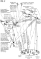
- Figure 2 illustrates a LEO Secondary GNSS-Constellation combined with Primary GNSS System(s).
- the multi-GNSS receiver will be in charge of calculating in real time the satellite position, and time (relative to UTC, see later) at a e.g. 1Hz rate.
- the corresponding quasi-instantaneous satellite positions and time are then provided to an On-Board Computer Unit (OBCU) in charge of deriving a prediction model (using for example a Keplerian model with additional orbit correction parameters for the orbit and a polynomial model for the clock offset) for the LEO satellite orbit and clock.
- OBCU On-Board Computer Unit
- Such prediction models can have a same format as typical models described in Signal-In-Space Interface Control Documents (SIS-ICD) and used by conventional GNSS constellations in order to reduce the impact onto the user equipment which will then implement the same method to apply the corrections to the pseudo-ranges of the conventional GNSS signals or to the pseudo-ranges of the LEO signals.
- Alternative prediction models for the orbits and for the clock of the LEO satellites might also need to be proposed when considering the specificity of the corresponding low-altitude orbits and on-board clocks.
- alternative orbit models can consider simplified ephemeris having less Keplerian and orbit correction parameters, or can consider the same number of Keplerian and orbit correction parameters but requiring a smaller number of bits used for their coding as a consequence of different LEO satellite altitude, and the possible smaller validity period, for example 10s or 5mn.
- Alternative orbit models can also simply encompass the coordinates of LEO satellite position estimated at each epoch, e.g. every second. In that case no ephemeris (i.e. Keplerian parameters) are transmitted.
- Alternative clock models can consider a polynomial of different order than the quadratic polynomial proposed for the GNSS on-board clocks, either because the stability of the on-board timing sub-system is worse and then necessitates an higher order for the same validity period, or because the validity period is much smaller, for example, 10s or 5mn in which case a lower order will be necessary.
- the prediction models are then encoded into a navigation message sent to the user equipment via the navigation signals whose carrier frequency is part of the frequency bands allotted to the Radio Navigation Satellite Service (RNSS) or Radio Determination Satellite Services (RDSS) in an ITU regulatory framework, or frequency bands shared with other non-positioning service but still susceptible to provide a positioning or localisation solution.
- RNSS Radio Navigation Satellite Service
- RDSS Radio Determination Satellite Services
- This "user signals LEO frequency” could be for example L-Band currently used by most of the actual GNSS and RNSS systems, C-Band with frequency between 5010 and 5030 MHz, or S-Band with frequency between 2483.5 and 2500MHz. Frequency bands such as Ku- / Ka-Band, could also be envisaged.
- the signal using the "user signals LEO frequency” can be used for ranging and also to disseminate the short term navigation message, and possibly together with additional data such as Delta code and/or carrier pseudo-ranges, and/or simple Delta code pseudo-ranges and/or double Delta code pseudo-ranges.
- Transmitting the navigation message in L-Band from LEO has the advantage to not require any significant hardware modification for the user equipments which could re-use the same front-end for the reception of the signals transmitted by the LEO satellites as the ones transmitted by the MEO satellites.
- the main drawback is that if the LEO satellite receives signals from the primary GNSS satellites and transmits signals to the user equipment in the same frequency band, the power level imbalance between both signal types could yield to strong cross-talk effects which could degrade or even hinder the reception of the primary GNSS satellite signals with the on-board multi-GNSS receiver.
- some mitigation solutions exist to ensure a sufficient isolation between the transmitting and receiving equipments for example by installing both equipments on two opposite panels of the LEO spacecraft which will serve as power attenuator.
- the LEO signals are transmitted in S-/C- or (Ku-/Ka-) bands different to the L-Band of the conventional GNSS constellations, there is no risk of RF cross-talk between reception of the "MEO-GNSS" L-Band signals and transmission of the "LEO-GNSS" S-/C-/Ku-/Ka- band signals. It is important to point out that if the GNSS primary systems use alternative frequency bands than the L-Band, such as the S-band for the Indian Regional Navigation System (IRNSS), then the LEO satellites shall transmit in another frequency band than the S-Band to avoid again RF cross-talks.
- alternative frequency bands than the L-Band such as the S-band for the Indian Regional Navigation System (IRNSS)
- Another advantage of the transmitting in another frequency band in comparison to L-Band, beside the cross-talk aspect, is that if interferers affect the reception in L-Band, then the reception of the LEO signals in another frequency band shall not be affected, improving the resilience of the positioning service.
- the main driver for the validity period of the correction model generated by the LEO satellite corresponds to the availability of the position fix from the at least one receiving units due to a possible lack of primary GNSSs' satellite visibility. Assuming for example visibility gaps of e.g. 5 mn, the validity period of the on-board generated clock and orbit models shall be at least 5mn.
- the satellite can be equipped with one or more GNSS antennas connected to the at least one receiving units or one or more multi-GNSS receiving units equipped each with its own antenna.
- the antennas could be mounted on the different satellite panels to maximize primary GNSS satellite visibility.
- Using a LEO platform typically flying between 200 and 2000 km has the advantage that the antenna(s) of the at least one receiving units can see multiple MEO satellites (GPS, Galileo, Glonass, etc.), when it is mounted on a "Back-panel" of the LEO satellite.
- Precise Orbit Determination An alternative variant based on-board Precise Orbit Determination (POD) algorithms can also be used to "fill the MEO visibility gaps", to still ensure availability of the orbit prediction models, even with lower accuracy, during those periods of time without visibility.
- POD Precise Orbit Determination
- Visibility gaps are avoided by a sufficient number of ranging sources to satisfy an accurate position of the LEO satellite which is also facilitated by a larger number of antennas having complementarity views of the geometry for the primary GNSS constellations.
- the system time of this secondary GNSS is the same as the one of the primary one.
- the clock correction models disseminated by the primary system enable to retrieve the system time of the primary system: for example the Galileo System Time (GST) in case the primary system is Galileo, or the GPS System Time (GPST) in case the primary system is GPS.
- GST Galileo System Time
- GPST GPS System Time
- the system time of the secondary GNSS is a common system time to all different primary systems. If a parameter represents an offset between the different primary systems, such as the Galileo-GPS System Time (GGTO) it is possible to relativize the clock corrections provided by both GNSS systems, and to adopt either the GPST or the GST as system time for the secondary GNSS. If no parameter represents the offset between the time scales of the primary systems, then a common system time to all systems could be the Universal Time Coordinate (UTC). All GNSSs provide effectively an offset in their respective navigation messages which enables to retrieve the UTC.
- GGTO Galileo-GPS System Time
- the PVT determination on-board the LEO satellite here referred to as satellite of a secondary GNSS in a Low Earth Orbit, LEO, is performed at a high rate (for example every second). Because the availability of a sufficient number of LOS satellites of the primary GNSS systems can be guaranteed, for example by having several GNSS antennas on the LEO satellite, it is possible to use clocks for a timing sub-system responsible of the navigation signal generation with a good stability only at short-term, and not for mid- or long term.
- Quartz oscillators such as (VC)TCXO or USO (OCXO) can be used.
- the satellites could be equipped with timing subsystems using quartz oscillators different to atomic clock technology and which would result in lowering the cost of the LEO satellite payload.
- the at least one receiving units can "discipline" their on-board clock with a time estimate calculated from the received GNSS signals.
- the timing sub-system can be used for the signal generation chain on-board the LEO satellite and to discipline this one with the time scale obtained from the PVT calculation. This timing sub-system would then serve for the generation of the LEO navigation message (via PPS and RF output) which are then transmitted in the "user signals LEO frequency", such as the L-/S-/Cor (Ku-/Ka-) frequencies.
- Another advantage to discipline the on-board timing sub-system with the common system time of the at least one primary GNSS system is that the predicted clock offset between the system time and the on-board clock, timing sub-system, will not exceed the number of bits allocated in the SIS-ICD of the current GNSS message structure to encode the coefficients for the clock correction model. Without disciplining, since the on-board clock is free-running, then the number of bits available in the current GNSS message structure to encode the aforementioned predicted offset might not be sufficient and an overflow effect might occur.
- the LEO satellites can be used as reference (pseudo-) stations. Therefore, it is mandatory to increase the pseudo-range estimation accuracy and to reduce the positioning error of the LEO satellites to a minimum.
- An objective of the disclosure consists therefore to reduce the corresponding contribution of the orbit and clock offset prediction error for the satellites of the primary GNSS systems which is demonstrated to be the largest contribution for the pseudo-range estimation accuracy and position error for a space-borne receiver.
- the following table provides the typical orders of magnitudes for the system/satellite contributions (satellite orbit and clock estimation errors), the atmospheric contributions (ionosphere, troposphere) and the local contributions (interferences, multipaths) which will impact the pseudo-range estimation accuracy for a terrestrial user equipment.
- the prediction accuracy for the orbit and clock of the satellites belonging to the primary GNSS system might propagate to the estimation accuracy of the orbits and clocks of the LEO satellites belonging to the secondary GNSS system.
- the prediction error for the satellite orbit and clock parameters is called Signal-In-Space-Accuracy (SISA) and can be up to 85cm, for a validity period of 100mn.
- SISA Signal-In-Space-Accuracy
- up to 85cm of LEO position accuracy will itself "propagate" to the user equipment position accuracy.
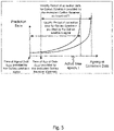
- Figure 3 illustrates a typical "profile" for a prediction error of a primary satellite's position, as function of the ageing of the model.
- the corresponding prediction error usually increases steeply, which hinders the use of the corresponding set of data for a period exceeding the nominal validity period.
- the receiver has to apply another set of data for the following period of time (also illustrated on the right side of figure 3 ).
- Figure 3 also highlights that even for a zero ageing (meaning that the correction has just been issued and made available to the GNSS receiver), the prediction error might not be null. For example, because the prediction model for the satellite orbit was not calculated when considering all forces applicable onto the satellite, or because limited quantisation of the coefficients used in the correction model degrade a prediction precision.
- the processing unit of each of the LEO satellites can apply different sets of orbit and clock corrections for the same satellite of the primary GNSS constellation.
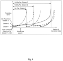
- Figure 4 illustrates the profiles for the ranging prediction error obtained by applying different sets of orbit and clock corrections corresponding to different correction models and applied for the same GNSS satellite of the primary GNSSs.
- three different sets orbit and clock corrections are proposed for illustration.
- Each set of orbit and clock correction is obtained by a different dissemination source which can be the signals of the GNSS satellites, the GEO satellites of the SBAS and/or a dedicated up-link to the LEO satellite.
- Figure 4 further illustrates the optimal, i.e. minimal, ranging prediction error profile symbolized with a line with square markers, and obtained after correction of the pseudo-range with the optimal set of orbit and clock corrections selected at each time epoch.
- the ageings of data for the three dissemination ways are identical for the first validity periods of each of the three dissemination ways, but due to the different values of the respective validity periods, the profiles become rapidly asynchronous.
- the "optimal" profile corresponds to the minimum of the three ones and is represented with a line using square markers.
- the objective is to determine for each satellite of the primary GNSS constellation, the optimal set of orbit and clock corrections among a set of many available. It must be noted that this optimisation (selection) might not be performed at each epoch or even not performed periodically. This means that the orbit and clock corrections made available by a given dissemination source can be retained and maintained over a period whose value might depend on the processing capacity of the on-board computer (the more resource available, the shorter is the period).
- Figure 5 illustrates the prediction error for the same Galileo satellite n provided either from the Galileo n signal or by the at least one dedicated Galileo Up-Link receiver on-board the LEO satellite. It appears that the selection of the optimal set of orbit and clock corrections can be based on AoD, Ageing of Correction Data, as shown on figure 5 , and/or any other ancillary parameters informing on the quality of the prediction error such as the SISA and the DVS/SHS flags for Galileo, or the URA for GPS. In the former example, the corrections provided by the at least one dedicated Galileo Up-Link receiver on-board the LEO satellites are the optimal ones.
- the possibility to get the orbit and clock corrections with a dedicated Galileo Up-Link receiver on-board the LEO satellite assumes that the same provider/operator, or a cooperative provider can authorize the Galileo corrections calculated by the OSPF to up-load it to the dedicated up-link receiver on-board the LEO satellites. Therefore, the secondary GNSS shares interfaces with the Galileo system.
- an alternative consists in using the set of orbit and clock corrections calculated by external services and to make them available to the LEO satellite.
- RTP real-time products
- IGS International GPS geodynamics Service
- EDAS EDAS data service
- dedicated up-link stations different from the Galileo Mission ULS
- receiver different from the dedicated Galileo Up-Link receiver
- Other types of orbit and clock correction models are also provided by other providers and usually made available over the internet to the final user.
- Such alternative models can also be up-loaded to a receiver on-board the LEO satellite. Again, a selection process between the corrections modulated onto the GNSS signals and the ones obtained from the RTP-IGS data can be performed to obtain the optimal set.
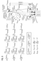
- Figure 6 illustrates a prediction/update process for the LEO satellite position calculation and selection of an optimal set of orbit and clock corrections for satellites of the primary GNSS.
- Figure 6 illustrates on the upper part the true and estimated positions for three satellites of the primary GNSS constellation(s) and at epoch (k), and on the lower part, the true/predicted and estimated positions of one LEO satellite of the secondary constellation at epoch (k-1) and (k).
- LEO satellite positions at epoch (k-1) are also illustrated in figure 6 .
- the LEO satellite located at its predicted or estimated position is represented with lighter (transparent) colour, while the LEO satellite located at its true position is represented with plane colours.
- the trajectory of the LEO satellite is depicted with a dashed line.
- a space multi-GNSS receiver, also referred to as receiving unit comprised by the LEO satellite is also symbolised by a conus on the rear of the LEO satellite.
- a single antenna is proposed for this illustration.
- the "true physical" distance between the LEO and the GNSS (sat 1) satellite is illustrated and labelled R LEO s 1 .
- the measured distance is also illustrated with dashed lines and labelled PR LEO s 1 , and is defined in equation (Eq. 18) page 29.
- the predicted distance between the predicted position of the LEO satellite and the predicted of the GNSS satellite, using the first set of orbit corrections is also represented with long-short dashed lines and labelled PR ⁇ LEO 1 , s 1 .
- the predicted distance between the predicted position of the LEO satellite and the predicted of the GNSS satellite, using the second set of orbit corrections is also represented with long-short dashed lines and labelled PR ⁇ LEO 2 , s 1 .
- the predicted distance between the predicted position of the LEO satellite and the predicted of the GNSS satellite, using the third set of orbit corrections is also represented with long-short dashed lines and labelled PR ⁇ LEO 3 , s 1 . See also equation (eq. 19) page 30 for a detailed definition of the corresponding predicted Pseudo-Ranges.
- a similar algorithm enables to predict the offset of the on-board LEO clock at epoch (k) based on an estimate of the on-board LEO clock at epoch (k-1), in a similar way to the algorithm for the orbit prediction and estimation.
- a Kalman Filter can be used for this purpose.
- the estimate of the on-board LEO clock at epoch (k-1) is called ⁇ LEO ( k -1) and is called ⁇ LEO ( k ) at epoch k.
- the prediction of the on-board LEO clock at epoch (k) is called ⁇ LEO ( k ) .
- the Galileo satellites Taking the example of the Galileo satellites, if 2 different orbit and clock correction inferences for one Galileo satellite are available at the LEO (the first correction inference is directly demodulated from the navigation message of this Galileo satellite, and the second is obtained from a dedicated Galileo up-link receiver mounted on-board the LEO-satellite), then the set having the latest AoD in combination with the smallest SISA/URA is retained for this pair of sub-sets.
- inference means that the same prediction model is used but different values for the corresponding model coefficients are applied due to the different AoDs.
- This preliminary pre-processing/pre-selection step enables to reduce the number of applicable and candidate orbit and clock correction sets from I* down to I.
- the 3 correction sets can be considered as unchanged over a period T which can encompass several seconds/minutes. Therefore at each epoch, k, it is proposed to verify if the same number and type of orbit and clock correction sets is applicable as at epoch (k-1).
- a Set Change Status_Flag flag is set to 1. If this is the case meaning that no change of the number and type of orbit and clock correction sets occurred, then the Set_Change_Status_Flag flag is set to 0 and for each correction set, the ageing is calculated, T ageing i , sn k as illustrated in figure 7 .
- the pre-selection operation applies, it is considered that I ⁇ 1 candidate sets of orbit and clock corrections are remaining and the optimal one needs to be selected.
- the predicted LEO satellite position [ x ⁇ LEO ( k ) ⁇ LEO ( k ) z LEO ( k )] T , based on the former history of estimates and measurements is the reference one. This assumption is possible when considering that on a one side the orbit of the LEO satellite is very stable, and on the other side that the models implemented in the On-Board Precise Orbit Determination process for the many different forces exercised onto the LEO satellite represent or are close to the physics (small modelling errors).
- PR LEO sn k x sn k ⁇ x LEO k 2 + y sn k ⁇ y LEO k 2 + z sn k ⁇ z LEO k 2 + c 0 ⁇ ⁇ LEO ⁇ ⁇ sn + ⁇ LEO , N 0 sn k
- x ⁇ sn i k , y ⁇ sn i k and z ⁇ sn i k are the predicted orbit coordinates obtained from the i th set of orbit correction for the GNSS satellite, n, and applied at epoch k.
- ⁇ ⁇ sn i k is the predicted time offset obtained from the i th set of clock correction for the GNSS satellite, n, and applied at epoch k.
- x ⁇ LEO ( k ), ⁇ LEO ( k ) and ⁇ LEO ( k ) are the predicted LEO orbit coordinates obtained from the Kalman Filter, processed on-board the LEO satellite, or any other precise orbit determination algorithm which enables to predict the LEO satellite position without pseudo-range measurements from the GNSS satellites.
- the predicted orbit coordinates, x ⁇ sn i k , y ⁇ sn i k and z ⁇ sn i k , for the n GNSS satellites, obtained with the i th set of orbit corrections should not be confused with the predicted orbit coordinates, x ⁇ LEO ( k ), ⁇ LEO ( k ) and ⁇ LEO ( k ), for the LEO satellite, obtained with the Kalman Filter, or any other precise orbit determination algorithm which enables to predict the LEO satellite position without pseudo-range measurements.
- ⁇ LEO ( k ) represents similarly the predicted time offset for the on-board clock of the LEO satellite, which can also be obtained from a Kalman Filter, or any other clock determination algorithm which enables to predict the LEO satellite clock without pseudo-range measurements from the GNSS satellites.
- the corresponding predicted pseudo-ranges are labelled, PR ⁇ LEO 1 , s 1 , PR ⁇ LEO 2 , s 1 and PR ⁇ LEO 3 , s 1 .
- ⁇ l represents weights which are used to increase or reduce the influence of the preceding prediction errors for the selection of i opt sn k .
- ⁇ norm represents either an absolute norm, or a quadratic norm.
- the former equation means that the optimal set of index i opt sn k , is the one which minimizes the cumulated and weighted sum of the prediction errors of the pseudo-range over the last K ageing i , sn k epochs. It has to be noticed that according to the selected weights ⁇ l the selection algorithm will favor a candidate set i opt sn k showing a prediction error which was lower at beginning of the common ageing period T ageing sn k , meaning I close to 1, if the weights ⁇ l are larger for such indexes l.
- the selection algorithm will favor a candidate set i opt sn k showing a prediction error which is lower at the end of the common ageing period T ageing sn k , meaning I close to ( K ageing i , sn k ⁇ 1 ), if the weights ⁇ l are larger for such indexes l.
- the index i opt sn k for the optimal set varies according to the epoch (k). This is for example visible on Figure 4 where the indexing of the set of orbit and clock corrections for the optimal dissemination source varies.
- the corresponding N pseudo-ranges can be corrected with the corresponding N optimal sets.
- Those N optimally corrected pseudo-ranges serve for the update step in the estimation/calculation process of the LEO satellite position (depicted with an arrow labeled "Update at epoch k" on figure 6 ).
- the N optimally corrected pseudo-ranges can be used to estimate the position of the LEO satellite in a simple point positioning algorithm, without using the Kalman Filter.
- the following equation provides the optimised Delta code pseudo-ranges obtained with the optimal set of orbit and clock corrections, with index i opt sn k .
- the corresponding optimal set will help minimizing the residual of the orbit and clock prediction model, ⁇ R ⁇ 0 , LEO i opt sn k .
- the former method enables to select at each epoch the optimal set of corrections originating from different dissemination sources, with a total number I*, and this for each satellite of the primary GNSSs.
- the main consequence is that based on the optimal sets, it is possible to deduce the position of the LEO satellite which minimises the propagation of the orbit and clock offset prediction error of the primary GNSS satellites onto the secondary GNSS LEO satellites.
- the index i sn GNSS P will be used for the set of orbit and clock corrections generated by the ODTS chain of the primary GNSS system P, and also disseminated by the signals transmitted by the satellite n of the GNSS system P.
- This can be the GPS or the Galileo Global Navigation Systems, or any other Regional Navigation System such as IRNSS, QZSS.
- ⁇ PR LEO sn GNSS P k R ⁇ 0 , LEO sn GNSS P ⁇ PR LEO sn GNSS P ⁇ x sn GNSS P ⁇ x ⁇ 0 , LEO R 0 , LEO sn GNSS P ⁇ ⁇ x LEO + y sn GNSS P ⁇ y ⁇ 0 , LEO R 0 , LEO sn GNSS P ⁇ ⁇ y LEO + z sn GNSS P ⁇ z ⁇ 0 , LEO R 0 , LEO sn GNSS P ⁇ ⁇ z LEO ⁇ c 0 ⁇ ⁇ LEO ⁇ ⁇ R ⁇ 0 , LEO i sn GNSS P ⁇ ⁇ LEO , N 0 sn
- the atmospherical contributions are non-applicable at LEO satellites, and the contributions of local radio frequency interference (RFI) and multipath (MP) can be reduced per design to a minimum at LEO spacecraft level. Further, a temperature stability on the signal generation chain combined with an accurate calibration of the hardware group delay can maintain the contribution of the hardware group delay at a sufficient low level. Finally, the optimal selection of the orbit and clock corrections will also minimize the impact of the orbit and clock offset prediction error onto the LEO satellite orbit and clock estimates. Therefore the contribution of all aforementioned residuals to the LEO orbit and clock offset prediction error can be reduced to a minimum. Thus, the LEO satellites can themselves be considered as very accurate positioning sources, and could play the role of reference "non-stationary" stations.
- the next step consists in describing how a navigation system based on the LEO satellites can be used to offer a High Accuracy Service for final user equipments making use of a GNSS system P, and also augment the performances of the GNSS P.
- the Pseudo range error calculated for a satellite n, n for example being 4, of the GNSS P, ⁇ PR r satn GNSSP , and obtained after linearization of the pseudo-range equation in the vicinity of the true receiver position is provided by the following equation.
- ⁇ PR r sn GNSS P R ⁇ 0 , r sn GNSS P ⁇ PR r sn GNSS P ⁇ x sn GNSS P ⁇ x ⁇ 0 , r R 0 , r sn GNSS P ⁇ ⁇ x r + y sn GNSS P ⁇ y ⁇ 0 , r R 0 , r sn GNSS P ⁇ ⁇ y r + z sn GNSS P ⁇ z ⁇ 0 , r R 0 , r sn GNSS P ⁇ ⁇ z r ⁇ c 0 ⁇ ⁇ r ⁇ ⁇ R 0 , r sn GNSS P ⁇ ⁇ I sn GNSS P ⁇ ⁇ T sn GNSS P ⁇ ⁇ RFI sn GNSS P ⁇ ⁇ MP sn GNSS P ⁇
- the generic Least Square method can be used to estimate the receiver position (x r , y r , z r ) and time offset ⁇ r , based on the pseudo-range measured by at least four LOS satellites of the primary GNSS.
- Other methods such as Monte-Carlo or gradient descent may be applicable.
- ⁇ res sn GNSS P represents the residual of the corrections for the Ionosphere, Atmosphere, Multipath, RFI and thermal noise disturbance parameters.
- ⁇ res sn GNSS P does not encompass the contribution for the orbit and clock offset prediction errors for the satellite n of GNSS P, ⁇ R ⁇ 0 , r sn GNSS P .
- the remaining contributions which need to be compensated are the residual for the satellite orbit prediction error ⁇ R ⁇ 0 , r orb , sn GNSS P , and satellite clock offset prediction error ⁇ sn GNSS P included into the term ⁇ R ⁇ 0 , r sn GNSS P .
- One solution consists in modulating such information onto the signal transmitted in the "user signals LEO frequency" (e.g.
- L-/S-/C-/Ku-/Ka- band L-/S-/C-/Ku-/Ka- band
- this information could then be used to correct and reduce ⁇ PR r sn GNSS P received in the L-Band. This helps reducing the effects of ODTS estimation error for the orbit and clock of the satellite n belonging to the primary GNSS system P.
- LEO orbit and clock information are part of the navigation message modulated onto a LEO navigation signal and using the "user signals LEO frequency" (e.g. L-/S-/C-/Ku-/Ka- band), as described earlier.
- LEO orbit and clock information can also be disseminated in a dedicated communication link between the LEO satellite and the user equipment, or finally can also be disseminated from the LEO to a ground station and then to the user equipment via a terrestrial link.
- This principle is similar to the one currently applied in Differential GPS systems or RTK positioning systems, having a network of terrestrial reference stations, which compute the pseudo-ranges w.r.t. the GNSS satellites and provide them to the final user via a communication link.
- the main difference resides in the fact that the references stations (i.e. the LEO satellites) are no more stationary but "moving". It is shown that the spatial correlation between the user equipment and the LEO satellites can be achieved when the number of LEO satellites is large enough. This spatial correlation is the fundamental principle for a differential GPS or Real-Time Kinematic positioning.
- Figure 8 illustrates a network for an exemplary LEO constellation used as secondary GNSS.
- Figure 8 represents a similar constellation to OneWeb with 648 satellites flying at an altitude of 1400km as baseline and constituted of 18 orbitals planes having each 36 satellites.
- a large density of flying reference stations can be achieved due to the large number of LEO satellites, which is a condition for the provision of a DGPS or RTK service, using spaceborne platforms.
- a simple baseline constituted of 3 LEO satellites and a terrestrial user equipment, Rx, within this baseline is presented.
- Figure 9 therefore illustrates the geometrical characteristics of the GNSS satellites belonging to the primary GNSS constellation, for example a Galileo constellation with a satellite altitude of 23000km. Two LEO satellites are also represented, at an altitude of ⁇ 1500km.
- Figure 9 illustrates spatial correlation for the impact of GNSS satellite orbit residuals at the LEO satellite and the user equipment.
- the vector for the prediction error between the true position of satellite sat n of GNSS P and its predicted position, V ⁇ ⁇ sn GNSSP is also illustrated, together with the vectors between the true satellite position and 1) the LEO1 true satellite position ( V ⁇ sn GNSSP LEO 1 ), 2) the LEO2 true satellite position ( V ⁇ sn GNSSP LEO 2 ), 3) the true user equipment position ( V ⁇ sn GNSSP r ) and 4) the coarse user equipment position, used for the linearization of the receiver position ( V ⁇ sn GNSSP 0 , r ).
- the contribution of the prediction error of the GNSS satellite is equal to the inner product between the orbit prediction vector error V ⁇ ⁇ sn GNSSP of the satellite n of GNSS P, and the normalized V 0, r vectors V ⁇ sn GNSS P 0 , r ⁇ V ⁇ sn GNSS P 0 , r ⁇ , (which can be approximated to the normalized vector between true position of satellite sat n of GNSS P and the true user equipment position, V ⁇ sn GNSS P r ⁇ V ⁇ sn GNSS P r ⁇ ).
- Figure 9 also highlights that the contribution of the prediction error of the satellite n of GNSS P, calculated at the user equipment position ( ⁇ R ⁇ 0 , r sn GNSS P ), can be approximated to the contribution of the orbit prediction error of satellite n of GNSS P calculated at the LEO1 position ( ⁇ R ⁇ LEO 1 sn GNSS P ) or at the LEO2 position ( ⁇ R ⁇ LEO 2 sn GNSS P ).
- ⁇ PR LEO sn GNSS P R ⁇ 0 , LEO sn GNSS P ⁇ PR LEO sn GNSS P ⁇ x sn GNSS P ⁇ x ⁇ 0 , LEO R 0 , LEO sn GNSS P ⁇ ⁇ x LEO + y sn GNSS P ⁇ y ⁇ 0 , LEO R 0 , LEO sn GNSS P ⁇ ⁇ y LEO + z sn GNSS P ⁇ z ⁇ 0 , LEO R 0 , LEO sn GNSS P ⁇ ⁇ z LEO ⁇ c 0 ⁇ ⁇ LEO ⁇ ⁇ R 0 , LEO sn GNSS P ⁇ ⁇ LEO , N 0 sn GNSS P
- ⁇ LEO sn GNSS P encompasses the thermal noise contribution and residual errors for the clock offset estimation, ⁇ LEO , of the LEO satellite and other pseudo-range error contributions such as for local MP and RFI.
- the LEO satellites disseminate their clock offsets, ⁇ LEO , then the corresponding at least four Delta code pseudo-ranges ⁇ PR LEO 1 sn GNSS P , ⁇ PR LEO 2 sn GNSS P , ⁇ PR LEO 3 sn GNSS P and ⁇ PR LEO 4 sn GNSS P can be measured by different LEO satellites LEO1, LEO2, LEO3 and LEO4.
- the user receiver / equipment will then subtract the corresponding spatially interpolated and precise Delta code pseudo-range, ⁇ PR sn GNSSp LEO , from ⁇ PR r sn GNSSp , yielding the corrected pseudo-range ( ⁇ PR r sn GNSSp ⁇ ⁇ PR sn GNSSp LEO ).
- the Delta code pseudo-ranges measured at each LEO satellite it is also possible to provide the "absolute" code pseudo-ranges PR LEO sn GNSS P to the user equipment, since this one has anyhow knowledge of the exact LEO satellite positions from the content of the navigation message including the predicted short term model and transmitted in the L-/C-/S-/K-/Ka frequency, and can therefore reconstruct the Delta code pseudo-ranges, ⁇ PR LEO sn GNSS P .
- the transmission of the absolute pseudo-ranges or the Delta code pseudo-ranges mainly impact the bandwidth required to transmit this amount of data.
- ⁇ LEO 1 In order to reduce the contribution of clock offset of the LEO satellite ⁇ LEO 1 and the associated prediction residual, ⁇ LEO 1 an alternative consists to build simple or double pseudo-range differences between the LEO satellites and the satellites of the primary GNSS and to transmit these simple/double differences to the user equipment.
- the simple differences enable to remove the contribution from LEO clock offset ⁇ LEO 1
- the double differences enable to remove the contribution from the GNSS satellite clock offsets.
- the simple differences ⁇ PR LEO 1 s 2 GNSS P , s 1 GNSS P and ⁇ PR LEO 2 s 2 GNSS P , s 1 GNSS P of (eq. 30) can be generated on-board each of the LEO1 and LEO2 satellites and can be disseminated to the terrestrial user equipment.
- the double differences of (eq. 31) it is necessary to exchange the Delta code pseudo-ranges between LEO satellites. Therefore an inter-satellite link is required to form such double differences. Once generated, the double differences can be disseminated to the user equipment.
- the orbit and clock correction model, of index i sn GNSS P which is used to compute the Delta code pseudo-range, ⁇ PR LEO 1 sn GNSSp , ⁇ PR LEO 2 sn GNSSp ,.. on-board the LEO satellites is the one modulated onto the signals transmitted by the satellites of the primary GNSS P that the user equipment will apply to perform its PVT calculation, and which contribution will be suppressed in the ( ⁇ PR r - ⁇ PR LEO1 ) subtraction.
- This correction model can be for example the GPS correction data modulated onto the GPS signals.
- Figure 10 schematically illustrates a method for each of a plurality of satellites of a secondary Global Navigation Satellite System, GNSS, in a Low Earth Orbit, LEO.
- the method comprises receiving S1010 multiple GNSS signals, in a first frequency band, from Line-of-sight, LOS, satellites of at least one primary GNSS, in particular primary GNSSs, in a Medium Earth Orbit, MEO.
- the method further comprises receiving S1020 candidate sets of orbit and clock corrections for the LOS satellites of the at least one primary GNSS.
- the method may further comprise determining S1030 an optimal set of orbit and clock corrections from the candidate sets of orbit and clock corrections.
- the method further comprises performing S1040 a Position-Velocity-Time, PVT, calculation based on code and/or carrier pseudo-ranges between a respective satellite of the plurality of satellites of the secondary GNSS and the LOS satellites of the at least one primary GNSS.
- the code and/or carrier pseudo-ranges are derived by the received multiple GNSS signals. Further, the code and/or carrier pseudo-ranges are corrected by a single set of the candidate sets of orbit and clock corrections. The single set may be the optimal set.
- the method further comprises determining S1050 a short term prediction model for an orbit and clock of the respective satellite of the plurality of satellites of the secondary GNSS based on the PVT.
- the method further comprises transmitting S1060, in a second frequency band which can be identical or different to the first frequency band, a navigation message modulated onto a LEO navigation signal intended for terrestrial user equipments, wherein the navigation message includes the short term prediction model.
- the method may further comprise transmitting S1070 to other LEO satellites simple Delta code and/or carrier pseudo-ranges measured between the satellites of the at least one primary GNSS to be augmented and the LEO satellites. The calculation is based on the set of orbit and clock corrections modulated onto the signals transmitted by the satellites of the primary GNSS to be augmented, in order to build double Delta code and/or carrier pseudo-ranges.
- the method may further comprise transmitting S1080 to the end-users either Delta code and/or carrier pseudo-ranges or simple Delta code and/or carrier pseudo-ranges or double Delta code and/or carrier pseudo-ranges, on a frequency which can be the same as for the LEO navigation signal or another communication frequency.
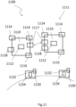
- FIG 11 schematically illustrates a system 1100 comprising the secondary GNSS 1111 and the terrestrial user equipment 1130. Satellites 1110 of the secondary GNSS 1111 operable in a Low Earth Orbit, LEO, are illustrated.
- the satellite 1110 comprises at least one receiving unit 1114, an on-board computer unit, OBCU, 1112 and a transmitting unit 1116.
- the satellite can further comprise at least one intercommunication module 1117, each adapted to perform intercommunication with other satellites of the secondary GNSS.
- the at least one receiving unit 1114 is adapted to receive multiple GNSS signals, in a first frequency band, from Line-of-sight, LOS, satellites of at least one primary GNSS, in particular primary GNSSs, in a Medium Earth Orbit, MEO.
- the at least one receiving unit 1114 is adapted to receive candidate sets of orbit and clock corrections for the LOS satellites of the at least one primary GNSS. Further, at least one other receiving unit 1118 is adapted to receive candidate sets of orbit and clock corrections for the LOS satellites of the at least one primary GNSS. The at least one other receiving unit 1118 is adapted to receive the candidate sets of orbit and clock corrections from ground or ground stations and/or SBAS.
- the on-board computer unit 1112 may be adapted to determine an optimal set of orbit and clock corrections from the candidate sets of orbit and clock corrections.
- the on-board computer unit 1112 is adapted to perform a Position-Velocity-Time, PVT, calculation based on pseudo-ranges between the LOS satellites of the at least one primary GNSS and the satellite.
- the pseudo-ranges are derived by the received multiple GNSS signals. Further, the pseudo-ranges are corrected by a single set of the candidate sets of orbit and clock corrections. The single set may be the optimal set. Further, the on-board computer unit 1112 is adapted to determine a short term prediction model for an orbit and clock of the satellite based on the PVT.
- the transmitting unit 1116 is adapted to transmit, in a second frequency band which can be identical or different to the first frequency band, a navigation message modulated onto a LEO navigation signal intended for terrestrial user equipments, wherein the navigation message includes the short term prediction model.
- the terrestrial user equipment 1130 is illustrated.
- the terrestrial user equipment 1130 comprises a receiving unit 1132 and a processing unit 1134.
- the receiving unit 1132 is adapted to receive the LEO navigation signals, together with navigation messages modulated on it, from the satellites 1110 of the secondary GNSS.
- the processing unit 1134 is adapted to determine a position based on the LEO navigation signals used for ranging and on the short term navigation message used to correct the obtained pseudo-ranges.
- the receiving unit 1132 is adapted to receive navigation signals from LOS satellites of the at least one primary GNSS.
- the processing unit 1134 is also adapted to determine an accurate position based on the navigation messages and the navigation signals from the LOS satellites of the at least one primary GNSS, and/or based either on the Delta code pseudo-ranges or on the simple Delta code pseudo-ranges or the double Delta code pseudo-ranges.
Landscapes
- Engineering & Computer Science (AREA)
- Radar, Positioning & Navigation (AREA)
- Remote Sensing (AREA)
- Computer Networks & Wireless Communication (AREA)
- Physics & Mathematics (AREA)
- General Physics & Mathematics (AREA)
- Position Fixing By Use Of Radio Waves (AREA)
Claims (6)
- Verfahren, das von jedem einer Vielzahl von Satelliten eines sekundären globalen Navigationssatellitensystems, GNSS, in einer erdnahen Umlaufbahn, LEO, durchgeführt wird, umfassend:Empfangen (S1010) mehrerer GNSS-Signale in einem ersten Frequenzband von Line-of-Sight, LOS, -Satelliten von primären GNSS in einer mittleren Erdumlaufbahn, MEO;Empfangen (S1020) von Kandidatensätzen von Orbit- und Taktkorrekturen für die LOS-Satelliten der primären GNSS, wobei die Kandidatensätze von Orbit- und Taktkorrekturen verschiedene Sätze von Orbit- und Taktkorrekturen für den gleichen Satelliten der primären GNSS darstellen und jeder Kandidatensatz von Orbit- und Taktkorrekturen durch eine unterschiedliche Verbreitungsquelle erhalten wird;Durchführen (S1040) einer Positions-Geschwindigkeits-Zeit, PVT, -Berechnung auf der Grundlage von Code- und/oder Träger-Pseudobereichen zwischen den LOS-Satelliten der primären GNSS und einem jeweiligen Satelliten der Vielzahl von Satelliten der sekundären GNSS, wobei die Code- und/oder Träger-Pseudobereiche aus den empfangenen mehreren GNSS-Signalen abgeleitet werden und wobei die Code- und/oder Träger-Pseudobereiche durch einen einzigen Satz der Kandidatensätze von Orbit- und Taktkorrekturen korrigiert werden;Bestimmen (S1050) eines kurzfristigen Vorhersagemodells für eine Umlaufbahn und eine Uhr des jeweiligen Satelliten der Vielzahl von Satelliten des sekundären GNSS auf der Grundlage der PVT;Übertragen (S1060) einer Navigationsnachricht, die auf ein LEO-Navigationssignal aufmoduliert ist, das für terrestrische Benutzergeräte bestimmt ist, in einem zweiten Frequenzband, das sich von dem ersten Frequenzband unterscheidet oder mit diesem identisch ist, wobei die Navigationsnachricht das kurzfristige Vorhersagemodell enthält, undwobei das Verfahren ferner umfasst:nach dem Empfangen (S1020) der Kandidatensätze von Orbit- und Taktkorrekturen, Bestimmen (S1030) eines optimalen Satzes von Orbit- und Taktkorrekturen aus den empfangenen Kandidatensätzen von Orbit- und Taktkorrekturen,wobei der einzige Satz der Kandidatensätze von Orbit- und Taktkorrekturen der optimale Satz von Orbit- und Taktkorrekturen ist, undwobei das Bestimmen (S1030) des optimalen Satzes von Orbit- und Taktkorrekturen aus den empfangenen Kandidatensätzen von Orbit- und Taktkorrekturen auf der Grundlage eines Vorhersagefehlers jedes der Kandidatensätze von Orbit- und Taktkorrekturen durchgeführt wird.
- Verfahren nach Anspruch 1, wobei das Bestimmen (S1030) des optimalen Satzes von Orbit- und Taktkorrekturen aus den empfangenen Kandidatensätzen von Orbit- und Taktkorrekturen ferner auf der Grundlage von Alterung von Korrekturdaten, AoD von jedem der Kandidatensätze von Orbit- und Taktkorrekturen durchgeführt wird.
- Verfahren nach Anspruch 1 oder 2, wobei der Schritt eines Empfangens der Kandidatensätze von Orbit- und Taktkorrekturen umfasst:Empfangen, von den LOS-Satelliten der primären GNSS, zumindest einen Teil der Kandidatensätze von Orbit- und Taktkorrekturen, die in einer für terrestrische Benutzergeräte bestimmten Navigationsnachricht enthalten ist;Empfangen, von einem oder mehreren weltraumgestützten Erweiterungssystemen, SBAS, in einer geostationären Erdumlaufbahn, GEO, von zumindest einem Teil der Kandidatensätze von Orbit- und Taktkorrekturen, die für terrestrische oder luftgestützte Benutzergeräte bestimmt sind;Empfangen, von mindestens einem On-Demand-Dienstanbieter, über ein Kommunikationsmodul auf dem jeweiligen Satelliten der Vielzahl von Satelliten des sekundären GNSS, mindestens eines Teils der Kandidatensätze von Orbit- und Taktkorrekturen; und/oderEmpfangen, von mindestens einem LEO-Satelliten der Vielzahl von Satelliten des sekundären GNSS und/oder von mindestens einem On-Demand GEO- oder MEO-Satelliten, über ein Interkommunikationsmodul auf dem jeweiligen Satelliten der Vielzahl von Satelliten des sekundären GNSS, mindestens eines Teils der Kandidatensätze von Orbit- und Taktkorrekturen.
- Satellit (1110) für ein sekundäres globales Navigationssatellitensystem, GNSS, (1111), der in einer erdnahen Umlaufbahn, LEO, betreibbar ist, aufweisend:mindestens eine Empfangseinheit (1114), die ausgebildet ist:mehrere GNSS-Signale, in einem ersten Frequenzband, von Line-of-Sight, LOS, -Satelliten von primären GNSS in einer mittleren Erdumlaufbahn, MEO, zu empfangen undKandidatensätze von Orbit- und Taktkorrekturen für die LOS-Satelliten der primären GNSS zu empfangen, wobei die Kandidatensätze von Orbit- und Taktkorrekturen verschiedene Sätze von Orbit- und Taktkorrekturen für den gleichen Satelliten der primären GNSS darstellen und jeder Kandidatensatz von Orbit- und Taktkorrekturen durch eine unterschiedliche Verbreitungsquelle erhalten wird;eine On-Board-Computereinheit, OBCU, (1112), die ausgebildet ist:eine Positions-Geschwindigkeits-Zeit, PVT, -Berechnung auf der Grundlage von Code- und/oder Träger-Pseudobereichen zwischen dem Satelliten und den LOS-Satelliten der primären GNSSs, wobei die Code- und/oder Träger-Pseudobereiche aus den empfangenen mehreren GNSS-Signalen abgeleitet werden und wobei die Pseudobereiche durch einen einzigen Satz der Kandidatensätze von Orbit- und Taktkorrekturen korrigiert werden, undBestimmen eines kurzfristigen Vorhersagemodells für eine Umlaufbahn und Uhr des Satelliten auf der Grundlage der PVT; undeine Sendeeinheit (1116), die ausgebildet ist, in einem zweiten Frequenzband, das sich von dem ersten Frequenzband unterscheidet oder mit diesem identisch ist, eine Navigationsnachricht zu senden, die auf ein LEO-Navigationssignal aufmoduliert ist, das für terrestrische Benutzergeräte bestimmt ist, und wobei die Navigationsnachricht das kurzfristige Vorhersagemodell aufweist, undwobei die OBCU ferner ausgebildet ist:einen optimalen Satz von Orbit- und Taktkorrekturen aus den Kandidatensätzen von Orbit- und Taktkorrekturen zu bestimmen, wobei der einzige Satz der Kandidatensätze von Orbit- und Taktkorrekturen der optimale Satz von Orbit- und Taktkorrekturen ist, undwobei das Bestimmen des optimalen Satzes von Orbit- und Taktkorrekturen aus den empfangenen Kandidatensätzen von Orbit- und Taktkorrekturen auf der Grundlage eines Vorhersagefehlers jedes der Kandidatensätze von Orbit- und Taktkorrekturen durchgeführt wird.
- Satellit nach Anspruch 4, wobei die OBCU ausgebildet ist:
den optimalen Satz von Orbit- und Taktkorrekturen aus den Kandidatensätzen von Orbit- und Taktkorrekturen auf der Grundlage von Alterung von Korrekturdaten, AoD, von jedem der Kandidatensätze von Orbit- und Taktkorrekturen zu bestimmen. - System (1100) aufweisend:ein sekundäres globales Satellitennavigationssystem (1111), GNSS, aufweisend einen Satelliten (1110) nach Anspruch 4 oder 5; undein terrestrisches Benutzergerät (1130).
Priority Applications (2)
| Application Number | Priority Date | Filing Date | Title |
|---|---|---|---|
| EP17153003.3A EP3355079B8 (de) | 2017-01-25 | 2017-01-25 | Verfahren für jeden von mehreren satelliten eines sekundären globalen navigationssatellitensystems auf einer niedrigen umlaufbahn |
| US15/879,631 US10859712B2 (en) | 2017-01-25 | 2018-01-25 | Method for each of a plurality of satellites of a secondary global navigation satellite system in a low earth orbit |
Applications Claiming Priority (1)
| Application Number | Priority Date | Filing Date | Title |
|---|---|---|---|
| EP17153003.3A EP3355079B8 (de) | 2017-01-25 | 2017-01-25 | Verfahren für jeden von mehreren satelliten eines sekundären globalen navigationssatellitensystems auf einer niedrigen umlaufbahn |
Publications (3)
| Publication Number | Publication Date |
|---|---|
| EP3355079A1 EP3355079A1 (de) | 2018-08-01 |
| EP3355079B1 true EP3355079B1 (de) | 2023-03-29 |
| EP3355079B8 EP3355079B8 (de) | 2023-06-21 |
Family
ID=57890737
Family Applications (1)
| Application Number | Title | Priority Date | Filing Date |
|---|---|---|---|
| EP17153003.3A Active EP3355079B8 (de) | 2017-01-25 | 2017-01-25 | Verfahren für jeden von mehreren satelliten eines sekundären globalen navigationssatellitensystems auf einer niedrigen umlaufbahn |
Country Status (2)
| Country | Link |
|---|---|
| US (1) | US10859712B2 (de) |
| EP (1) | EP3355079B8 (de) |
Cited By (1)
| Publication number | Priority date | Publication date | Assignee | Title |
|---|---|---|---|---|
| US20240393476A1 (en) * | 2023-05-28 | 2024-11-28 | Albora Technologies Limited | Global navigation satellite system (gnss) positioning with compressed observables |
Families Citing this family (39)
| Publication number | Priority date | Publication date | Assignee | Title |
|---|---|---|---|---|
| EP3777438B1 (de) * | 2018-04-03 | 2023-10-11 | InterDigital Patent Holdings, Inc. | Zeitvorlauf für nicht terrestrische netzwerkkommunikation |
| CN109100748B (zh) * | 2018-08-14 | 2020-11-10 | 西安空间无线电技术研究所 | 一种基于低轨星座的导航完好性监测系统及方法 |
| EP3620824B1 (de) * | 2018-09-06 | 2023-03-01 | Airbus Defence and Space GmbH | Virtuell referenziertes bodenzeitpositionierungs- und -zeitsystem |
| US11543783B2 (en) * | 2018-09-24 | 2023-01-03 | Qualcomm Incorporated | Position velocity assisted clock estimation |
| CN110231037B (zh) * | 2019-05-24 | 2020-11-17 | 武汉大学 | 一种附加钟差模型约束的gnss机动卫星定轨方法 |
| US11513232B2 (en) | 2019-05-28 | 2022-11-29 | Xona Space Systems Inc. | Satellite for broadcasting high precision data |
| US11899120B2 (en) | 2021-06-30 | 2024-02-13 | Xona Space Systems Inc. | Generation and transmission of navigation signals |
| US11668834B2 (en) | 2019-05-28 | 2023-06-06 | Xona Space Systems Inc. | Satellite for transmitting a navigation signal in a satellite constellation system |
| US12228654B2 (en) | 2019-05-28 | 2025-02-18 | Xona Space Systems Inc. | Satellite constellation system for facilitating enhanced positioning and nodes for use therewith |
| US12366665B2 (en) | 2019-05-28 | 2025-07-22 | Xona Space Systems Inc. | LEO satellite constellation system for facilitating enhanced positioning and methods for use therewith |
| US12189041B2 (en) | 2019-05-28 | 2025-01-07 | Xona Space Systems Inc. | Satellite constellation system for facilitating enhanced positioning and gateway for use therewith |
| US11668843B2 (en) | 2019-05-28 | 2023-06-06 | Xona Space Systems Inc. | Satellite for broadcasting clock state data |
| JP7391429B2 (ja) * | 2019-08-23 | 2023-12-05 | 長沙天儀空間科技研究院有限公司 | 衛星編隊ベースの遠隔検知システム及びコンステレーションシステム |
| CN110988933B (zh) * | 2019-10-31 | 2023-03-28 | 太原理工大学 | 一种基于模拟退火和梯度下降的选星方法 |
| US11447273B1 (en) * | 2020-02-24 | 2022-09-20 | Amazon Technologies, Inc. | Orbit determination service |
| CN111505679B (zh) * | 2020-04-20 | 2022-05-03 | 中国科学院国家空间科学中心 | 一种基于星载gnss的leo初轨确定方法 |
| CN113740891B (zh) * | 2020-05-29 | 2024-09-06 | 华为技术有限公司 | 利用导航卫星确定终端设备位置和速度的方法及电子装置 |
| FR3110975B1 (fr) * | 2020-05-29 | 2023-01-20 | Syntony | Méthode de positionnement gnss déportée dans le cloud |
| CN112083449B (zh) * | 2020-09-14 | 2023-11-28 | 中国科学院微小卫星创新研究院 | 一种ngso卫星覆盖区最小干扰角区域的定位方法 |
| CN116249916B (zh) * | 2020-10-15 | 2025-04-25 | 华为技术有限公司 | 一种卫星信号处理方法及卫星定位装置 |
| CN112491461B (zh) * | 2020-11-24 | 2023-03-24 | 重庆两江卫星移动通信有限公司 | 一种低轨卫星通信的cors网络数据传输系统及方法 |
| CN112882067B (zh) * | 2021-01-29 | 2024-05-28 | 重庆两江卫星移动通信有限公司 | 利用leo获取卫星精密轨道与钟差的方法及系统 |
| CN112924993B (zh) * | 2021-02-07 | 2024-06-04 | 重庆两江卫星移动通信有限公司 | 一种leo星座完好性监测方法及系统 |
| US12591068B1 (en) | 2021-03-04 | 2026-03-31 | Apple Inc. | LEO satellite connection assistance using MEO satellite signal data |
| CN113131991B (zh) * | 2021-04-06 | 2022-09-23 | 航天科工空间工程发展有限公司 | 一种基于单定位天线的高低轨兼容动中通方法 |
| EP4327130B1 (de) * | 2021-04-20 | 2026-02-11 | Xona Space Systems Inc. | Satellitenkonstellationssystem zur übertragung von navigationssignalen |
| CN113381800B (zh) * | 2021-06-10 | 2023-01-10 | 北京北斗博通科技有限公司 | 一种全向rdss通信终端、报文接收方法和发送方法 |
| CN113625315B (zh) * | 2021-06-21 | 2024-02-09 | 航天恒星科技有限公司 | 一种兼容北斗三号rnss和rdss信号处理于一体的系统 |
| CN114296790B (zh) * | 2021-12-29 | 2023-03-24 | 浙江时空道宇科技有限公司 | 卫星在轨软件重构方法、卫星系统及地面运控系统 |
| CN114499765B (zh) * | 2022-04-14 | 2022-08-16 | 航天宏图信息技术股份有限公司 | 一种基于北斗短报文的数据传输方法和系统 |
| US12248082B2 (en) * | 2022-05-31 | 2025-03-11 | Qualcomm Incorporated | Position-grid based machine learning for GNSS warm-start position accuracy improvement |
| US12252274B2 (en) * | 2022-05-31 | 2025-03-18 | Qualcomm Incorporated | Space vehicle geometry based machine learning for measurement error detection and classification |
| CN115390096B (zh) * | 2022-08-29 | 2023-04-25 | 浙江大学 | 基于全视角星载gnss接收系统的低轨卫星实时相对定轨方法 |
| CN115549753B (zh) * | 2022-09-02 | 2023-07-04 | 湖北第二师范学院 | 一种gnss辅助的leo地面通信收发系统及方法 |
| CN115623582B (zh) * | 2022-12-20 | 2023-03-28 | 浙江吉利控股集团有限公司 | 一种低轨卫星星座时间同步方法、系统、装置及介质 |
| CN116893438B (zh) * | 2023-09-11 | 2023-12-01 | 中国科学院国家授时中心 | 顾及钟差模型的低轨卫星钟差的确定方法及系统 |
| CN117991303B (zh) * | 2024-04-03 | 2024-06-14 | 武汉大学 | 一种天线环境变化情况下的多路径误差修正方法及装置 |
| CN118330683B (zh) * | 2024-06-17 | 2024-08-23 | 山东建筑大学 | 一种顾及低轨星座导航增强的电离层模型建模方法 |
| CN119148180B (zh) * | 2024-11-15 | 2025-02-11 | 中国科学院国家授时中心 | 一种低轨卫星实时定轨触发启动方法 |
Family Cites Families (25)
| Publication number | Priority date | Publication date | Assignee | Title |
|---|---|---|---|---|
| US5812961A (en) | 1995-12-28 | 1998-09-22 | Trimble Navigation Limited | Method and reciever using a low earth orbiting satellite signal to augment the global positioning system |
| WO1998043372A1 (en) | 1997-03-21 | 1998-10-01 | The Board Of Trustees Of The Leland Stanford Junior University | A system using leo satellites for centimeter-level navigation |
| US5886666A (en) | 1998-07-16 | 1999-03-23 | Rockwell International | Airborne pseudolite navigation system |
| US6785553B2 (en) | 1998-12-10 | 2004-08-31 | The Directv Group, Inc. | Position location of multiple transponding platforms and users using two-way ranging as a calibration reference for GPS |
| US6920309B1 (en) | 1999-03-18 | 2005-07-19 | The Directv Group, Inc. | User positioning technique for multi-platform communication system |
| US7042392B2 (en) | 2003-05-30 | 2006-05-09 | The Boeing Company | GPS access system and method |
| US7366125B1 (en) * | 2003-07-24 | 2008-04-29 | Bbn Technologies Corp. | Extensible satellite communication system |
| US7904243B2 (en) * | 2004-01-15 | 2011-03-08 | The Boeing Company | Real-time data aiding for enhanced GPS performance |
| US7489926B2 (en) | 2004-01-15 | 2009-02-10 | The Boeing Company | LEO-based positioning system for indoor and stand-alone navigation |
| US7142159B1 (en) | 2004-12-11 | 2006-11-28 | Rockwell Collins, Inc. | Pseudolite navigation system |
| US7792487B2 (en) * | 2006-01-04 | 2010-09-07 | Globalstar, Inc. | Satellite communication system for communicating packet data messages |
| US8296051B2 (en) | 2006-05-18 | 2012-10-23 | The Boeing Company | Generalized high performance navigation system |
| US7583225B2 (en) * | 2006-05-18 | 2009-09-01 | The Boeing Company | Low earth orbit satellite data uplink |
| US9121932B2 (en) * | 2008-01-10 | 2015-09-01 | Trimble Navigation Limited | Refining a position estimate of a low earth orbiting satellite |
| US7728759B2 (en) * | 2008-01-25 | 2010-06-01 | The Boeing Company | System and method for using iridium satellite signals for meteorological measurements |
| US8570216B2 (en) * | 2008-05-30 | 2013-10-29 | The Boeing Company | Differential correction system enhancement leverages roving receivers enabled for a non-GPS, secondary PN and T signal to characterize local errors |
| JP5683461B2 (ja) * | 2009-06-02 | 2015-03-11 | 古野電気株式会社 | Gnss受信装置 |
| US20110238308A1 (en) * | 2010-03-26 | 2011-09-29 | Isaac Thomas Miller | Pedal navigation using leo signals and body-mounted sensors |
| US8989652B2 (en) * | 2011-09-09 | 2015-03-24 | The Boeing Company | Advanced timing and time transfer for satellite constellations using crosslink ranging and an accurate time source |
| US8811614B2 (en) * | 2012-10-16 | 2014-08-19 | The Boeing Company | Space based authentication utilizing signals from low and medium earth orbit |
| US9557422B1 (en) * | 2012-12-11 | 2017-01-31 | Apple Inc. | Systems, methods, devices and subassemblies for creating and delivering a GNSS augmentation service |
| US9612340B1 (en) * | 2013-02-25 | 2017-04-04 | Apple Inc. | Systems, methods, devices and subassemblies for creating and delivering crowd-sourced GNSS models |
| JP6152663B2 (ja) * | 2013-03-07 | 2017-06-28 | セイコーエプソン株式会社 | 位置算出装置の制御方法及び位置算出装置 |
| US9829558B2 (en) * | 2014-09-26 | 2017-11-28 | Raytheon Company | Determination of a ground receiver position |
| FR3037661B1 (fr) * | 2015-06-17 | 2020-06-12 | Thales | Systeme d'augmentation spatial ou aeronautique avec gestion simplifiee de ses messages de navigation |
-
2017
- 2017-01-25 EP EP17153003.3A patent/EP3355079B8/de active Active
-
2018
- 2018-01-25 US US15/879,631 patent/US10859712B2/en active Active
Cited By (1)
| Publication number | Priority date | Publication date | Assignee | Title |
|---|---|---|---|---|
| US20240393476A1 (en) * | 2023-05-28 | 2024-11-28 | Albora Technologies Limited | Global navigation satellite system (gnss) positioning with compressed observables |
Also Published As
| Publication number | Publication date |
|---|---|
| US10859712B2 (en) | 2020-12-08 |
| EP3355079A1 (de) | 2018-08-01 |
| US20180210090A1 (en) | 2018-07-26 |
| EP3355079B8 (de) | 2023-06-21 |
Similar Documents
| Publication | Publication Date | Title |
|---|---|---|
| US10859712B2 (en) | Method for each of a plurality of satellites of a secondary global navigation satellite system in a low earth orbit | |
| Hauschild et al. | Precise real‐time navigation of LEO satellites using GNSS broadcast ephemerides | |
| Montenbruck et al. | Initial assessment of the COMPASS/BeiDou-2 regional navigation satellite system | |
| US8134497B2 (en) | Method and system for location-dependent time-specific correction data | |
| EP2741108B1 (de) | Verfahren zur Bestimmung der Position eines Satelliten mit hoher Umlaufbahn | |
| US10191157B2 (en) | Precise low-latency GNSS satellite clock estimation | |
| EP3373043B1 (de) | Verfahren zur positionsmessung mit inter-kanal-messabweichungskompensation | |
| EP3035080B1 (de) | Satellitennavigationssystem mit Positionierung mit Erzeugung von Korrektur-Informationen | |
| EP2673658B1 (de) | Verfahren und system zur bestimmung von taktkorrekturen | |
| Zhou et al. | Orbit determination and time synchronization for a GEO/IGSO satellite navigation constellation with regional tracking network | |
| CN1109251C (zh) | 卫星无线电测定 | |
| WO2019233046A1 (zh) | 一种导航增强方法及系统 | |
| Walter | Satellite based augmentation systems | |
| Yan et al. | Early analysis of precise orbit and clock offset determination for the satellites of the global BeiDou-3 system | |
| Huang et al. | BeiDou time transfer with the standard CGGTTS | |
| US20260043927A1 (en) | Satellite-Based Source of Positioning System-Independent Position Navigation and Time | |
| CN119998675A (zh) | 卫星有效载荷及其运行方法 | |
| CN118425998A (zh) | 一种gnss全时段实时卫星钟差估计方法及系统 | |
| US11525924B2 (en) | Method for providing authenticated correction information, plurality of reference stations and a redundant central computation unit, GNS system and software product and/or network for providing a correction information message in a GNS system or other means | |
| Montenbruck et al. | GNSS-based synchronization and monitoring of LEO-PNT onboard time | |
| US20160077211A1 (en) | Method and system for dynamic-to-dynamic precise relative positioning using global navigation satellite systems | |
| EP3620824A1 (de) | Virtuell referenziertes bodenzeitpositionierungs- und -zeitsystem | |
| Akiyama et al. | Improving QZSS Precise Orbit Determination using Space-based and Ground-based Observations | |
| Wübbena | On the modelling of GNSS observations for highprecision position determination | |
| Labé et al. | New Orbit Determination and Clock synchronisation modules for EGNOS |
Legal Events
| Date | Code | Title | Description |
|---|---|---|---|
| PUAI | Public reference made under article 153(3) epc to a published international application that has entered the european phase |
Free format text: ORIGINAL CODE: 0009012 |
|
| STAA | Information on the status of an ep patent application or granted ep patent |
Free format text: STATUS: REQUEST FOR EXAMINATION WAS MADE |
|
| 17P | Request for examination filed |
Effective date: 20171204 |
|
| AK | Designated contracting states |
Kind code of ref document: A1 Designated state(s): AL AT BE BG CH CY CZ DE DK EE ES FI FR GB GR HR HU IE IS IT LI LT LU LV MC MK MT NL NO PL PT RO RS SE SI SK SM TR |
|
| AX | Request for extension of the european patent |
Extension state: BA ME |
|
| STAA | Information on the status of an ep patent application or granted ep patent |
Free format text: STATUS: EXAMINATION IS IN PROGRESS |
|
| 17Q | First examination report despatched |
Effective date: 20181217 |
|
| GRAP | Despatch of communication of intention to grant a patent |
Free format text: ORIGINAL CODE: EPIDOSNIGR1 |
|
| STAA | Information on the status of an ep patent application or granted ep patent |
Free format text: STATUS: GRANT OF PATENT IS INTENDED |
|
| INTG | Intention to grant announced |
Effective date: 20221021 |
|
| GRAS | Grant fee paid |
Free format text: ORIGINAL CODE: EPIDOSNIGR3 |
|
| GRAA | (expected) grant |
Free format text: ORIGINAL CODE: 0009210 |
|
| STAA | Information on the status of an ep patent application or granted ep patent |
Free format text: STATUS: THE PATENT HAS BEEN GRANTED |
|
| AK | Designated contracting states |
Kind code of ref document: B1 Designated state(s): AL AT BE BG CH CY CZ DE DK EE ES FI FR GB GR HR HU IE IS IT LI LT LU LV MC MK MT NL NO PL PT RO RS SE SI SK SM TR |
|
| REG | Reference to a national code |
Ref country code: GB Ref legal event code: FG4D |
|
| REG | Reference to a national code |
Ref country code: CH Ref legal event code: EP |
|
| REG | Reference to a national code |
Ref country code: DE Ref legal event code: R096 Ref document number: 602017067151 Country of ref document: DE |
|
| REG | Reference to a national code |
Ref country code: AT Ref legal event code: REF Ref document number: 1557083 Country of ref document: AT Kind code of ref document: T Effective date: 20230415 |
|
| REG | Reference to a national code |
Ref country code: IE Ref legal event code: FG4D |
|
| GRAT | Correction requested after decision to grant or after decision to maintain patent in amended form |
Free format text: ORIGINAL CODE: EPIDOSNCDEC |
|
| REG | Reference to a national code |
Ref country code: CH Ref legal event code: PK Free format text: BERICHTIGUNG B8 Ref country code: CH Ref legal event code: PK Free format text: BERICHTIGUNGEN |
|
| RIN2 | Information on inventor provided after grant (corrected) |
Inventor name: HEIM, JENS Inventor name: BAUR, OLIVER Inventor name: SASSEN, STEFAN Inventor name: ZENZINGER, ALEXANDER Inventor name: FLOCH, JEAN-JACQUES Inventor name: OUEDRAOGO, MAHAMOUDOU Inventor name: SOUALLE, FRANCIS |
|
| REG | Reference to a national code |
Ref country code: LT Ref legal event code: MG9D |
|
| PG25 | Lapsed in a contracting state [announced via postgrant information from national office to epo] |
Ref country code: RS Free format text: LAPSE BECAUSE OF FAILURE TO SUBMIT A TRANSLATION OF THE DESCRIPTION OR TO PAY THE FEE WITHIN THE PRESCRIBED TIME-LIMIT Effective date: 20230329 Ref country code: NO Free format text: LAPSE BECAUSE OF FAILURE TO SUBMIT A TRANSLATION OF THE DESCRIPTION OR TO PAY THE FEE WITHIN THE PRESCRIBED TIME-LIMIT Effective date: 20230629 Ref country code: LV Free format text: LAPSE BECAUSE OF FAILURE TO SUBMIT A TRANSLATION OF THE DESCRIPTION OR TO PAY THE FEE WITHIN THE PRESCRIBED TIME-LIMIT Effective date: 20230329 Ref country code: LT Free format text: LAPSE BECAUSE OF FAILURE TO SUBMIT A TRANSLATION OF THE DESCRIPTION OR TO PAY THE FEE WITHIN THE PRESCRIBED TIME-LIMIT Effective date: 20230329 Ref country code: HR Free format text: LAPSE BECAUSE OF FAILURE TO SUBMIT A TRANSLATION OF THE DESCRIPTION OR TO PAY THE FEE WITHIN THE PRESCRIBED TIME-LIMIT Effective date: 20230329 |
|
| REG | Reference to a national code |
Ref country code: NL Ref legal event code: MP Effective date: 20230329 |
|
| REG | Reference to a national code |
Ref country code: AT Ref legal event code: MK05 Ref document number: 1557083 Country of ref document: AT Kind code of ref document: T Effective date: 20230329 |
|
| PG25 | Lapsed in a contracting state [announced via postgrant information from national office to epo] |
Ref country code: SE Free format text: LAPSE BECAUSE OF FAILURE TO SUBMIT A TRANSLATION OF THE DESCRIPTION OR TO PAY THE FEE WITHIN THE PRESCRIBED TIME-LIMIT Effective date: 20230329 Ref country code: NL Free format text: LAPSE BECAUSE OF FAILURE TO SUBMIT A TRANSLATION OF THE DESCRIPTION OR TO PAY THE FEE WITHIN THE PRESCRIBED TIME-LIMIT Effective date: 20230329 Ref country code: GR Free format text: LAPSE BECAUSE OF FAILURE TO SUBMIT A TRANSLATION OF THE DESCRIPTION OR TO PAY THE FEE WITHIN THE PRESCRIBED TIME-LIMIT Effective date: 20230630 Ref country code: FI Free format text: LAPSE BECAUSE OF FAILURE TO SUBMIT A TRANSLATION OF THE DESCRIPTION OR TO PAY THE FEE WITHIN THE PRESCRIBED TIME-LIMIT Effective date: 20230329 |
|
| PG25 | Lapsed in a contracting state [announced via postgrant information from national office to epo] |
Ref country code: SM Free format text: LAPSE BECAUSE OF FAILURE TO SUBMIT A TRANSLATION OF THE DESCRIPTION OR TO PAY THE FEE WITHIN THE PRESCRIBED TIME-LIMIT Effective date: 20230329 Ref country code: RO Free format text: LAPSE BECAUSE OF FAILURE TO SUBMIT A TRANSLATION OF THE DESCRIPTION OR TO PAY THE FEE WITHIN THE PRESCRIBED TIME-LIMIT Effective date: 20230329 Ref country code: PT Free format text: LAPSE BECAUSE OF FAILURE TO SUBMIT A TRANSLATION OF THE DESCRIPTION OR TO PAY THE FEE WITHIN THE PRESCRIBED TIME-LIMIT Effective date: 20230731 Ref country code: ES Free format text: LAPSE BECAUSE OF FAILURE TO SUBMIT A TRANSLATION OF THE DESCRIPTION OR TO PAY THE FEE WITHIN THE PRESCRIBED TIME-LIMIT Effective date: 20230329 Ref country code: EE Free format text: LAPSE BECAUSE OF FAILURE TO SUBMIT A TRANSLATION OF THE DESCRIPTION OR TO PAY THE FEE WITHIN THE PRESCRIBED TIME-LIMIT Effective date: 20230329 Ref country code: AT Free format text: LAPSE BECAUSE OF FAILURE TO SUBMIT A TRANSLATION OF THE DESCRIPTION OR TO PAY THE FEE WITHIN THE PRESCRIBED TIME-LIMIT Effective date: 20230329 |
|
| PG25 | Lapsed in a contracting state [announced via postgrant information from national office to epo] |
Ref country code: SK Free format text: LAPSE BECAUSE OF FAILURE TO SUBMIT A TRANSLATION OF THE DESCRIPTION OR TO PAY THE FEE WITHIN THE PRESCRIBED TIME-LIMIT Effective date: 20230329 Ref country code: PL Free format text: LAPSE BECAUSE OF FAILURE TO SUBMIT A TRANSLATION OF THE DESCRIPTION OR TO PAY THE FEE WITHIN THE PRESCRIBED TIME-LIMIT Effective date: 20230329 Ref country code: IS Free format text: LAPSE BECAUSE OF FAILURE TO SUBMIT A TRANSLATION OF THE DESCRIPTION OR TO PAY THE FEE WITHIN THE PRESCRIBED TIME-LIMIT Effective date: 20230729 |
|
| REG | Reference to a national code |
Ref country code: DE Ref legal event code: R097 Ref document number: 602017067151 Country of ref document: DE |
|
| PG25 | Lapsed in a contracting state [announced via postgrant information from national office to epo] |
Ref country code: DK Free format text: LAPSE BECAUSE OF FAILURE TO SUBMIT A TRANSLATION OF THE DESCRIPTION OR TO PAY THE FEE WITHIN THE PRESCRIBED TIME-LIMIT Effective date: 20230329 Ref country code: CZ Free format text: LAPSE BECAUSE OF FAILURE TO SUBMIT A TRANSLATION OF THE DESCRIPTION OR TO PAY THE FEE WITHIN THE PRESCRIBED TIME-LIMIT Effective date: 20230329 |
|
| PLBE | No opposition filed within time limit |
Free format text: ORIGINAL CODE: 0009261 |
|
| STAA | Information on the status of an ep patent application or granted ep patent |
Free format text: STATUS: NO OPPOSITION FILED WITHIN TIME LIMIT |
|
| 26N | No opposition filed |
Effective date: 20240103 |
|
| PG25 | Lapsed in a contracting state [announced via postgrant information from national office to epo] |
Ref country code: SI Free format text: LAPSE BECAUSE OF FAILURE TO SUBMIT A TRANSLATION OF THE DESCRIPTION OR TO PAY THE FEE WITHIN THE PRESCRIBED TIME-LIMIT Effective date: 20230329 |
|
| PG25 | Lapsed in a contracting state [announced via postgrant information from national office to epo] |
Ref country code: SI Free format text: LAPSE BECAUSE OF FAILURE TO SUBMIT A TRANSLATION OF THE DESCRIPTION OR TO PAY THE FEE WITHIN THE PRESCRIBED TIME-LIMIT Effective date: 20230329 Ref country code: IT Free format text: LAPSE BECAUSE OF FAILURE TO SUBMIT A TRANSLATION OF THE DESCRIPTION OR TO PAY THE FEE WITHIN THE PRESCRIBED TIME-LIMIT Effective date: 20230329 |
|
| PG25 | Lapsed in a contracting state [announced via postgrant information from national office to epo] |
Ref country code: MC Free format text: LAPSE BECAUSE OF FAILURE TO SUBMIT A TRANSLATION OF THE DESCRIPTION OR TO PAY THE FEE WITHIN THE PRESCRIBED TIME-LIMIT Effective date: 20230329 |
|
| PG25 | Lapsed in a contracting state [announced via postgrant information from national office to epo] |
Ref country code: MC Free format text: LAPSE BECAUSE OF FAILURE TO SUBMIT A TRANSLATION OF THE DESCRIPTION OR TO PAY THE FEE WITHIN THE PRESCRIBED TIME-LIMIT Effective date: 20230329 |
|
| REG | Reference to a national code |
Ref country code: CH Ref legal event code: PL |
|
| PG25 | Lapsed in a contracting state [announced via postgrant information from national office to epo] |
Ref country code: LU Free format text: LAPSE BECAUSE OF NON-PAYMENT OF DUE FEES Effective date: 20240125 |
|
| PG25 | Lapsed in a contracting state [announced via postgrant information from national office to epo] |
Ref country code: LU Free format text: LAPSE BECAUSE OF NON-PAYMENT OF DUE FEES Effective date: 20240125 |
|
| PG25 | Lapsed in a contracting state [announced via postgrant information from national office to epo] |
Ref country code: BE Free format text: LAPSE BECAUSE OF NON-PAYMENT OF DUE FEES Effective date: 20240131 |
|
| PG25 | Lapsed in a contracting state [announced via postgrant information from national office to epo] |
Ref country code: CH Free format text: LAPSE BECAUSE OF NON-PAYMENT OF DUE FEES Effective date: 20240131 |
|
| PG25 | Lapsed in a contracting state [announced via postgrant information from national office to epo] |
Ref country code: CH Free format text: LAPSE BECAUSE OF NON-PAYMENT OF DUE FEES Effective date: 20240131 Ref country code: BE Free format text: LAPSE BECAUSE OF NON-PAYMENT OF DUE FEES Effective date: 20240131 |
|
| REG | Reference to a national code |
Ref country code: BE Ref legal event code: MM Effective date: 20240131 |
|
| PG25 | Lapsed in a contracting state [announced via postgrant information from national office to epo] |
Ref country code: BG Free format text: LAPSE BECAUSE OF FAILURE TO SUBMIT A TRANSLATION OF THE DESCRIPTION OR TO PAY THE FEE WITHIN THE PRESCRIBED TIME-LIMIT Effective date: 20230329 |
|
| PG25 | Lapsed in a contracting state [announced via postgrant information from national office to epo] |
Ref country code: BG Free format text: LAPSE BECAUSE OF FAILURE TO SUBMIT A TRANSLATION OF THE DESCRIPTION OR TO PAY THE FEE WITHIN THE PRESCRIBED TIME-LIMIT Effective date: 20230329 |
|
| PG25 | Lapsed in a contracting state [announced via postgrant information from national office to epo] |
Ref country code: IE Free format text: LAPSE BECAUSE OF NON-PAYMENT OF DUE FEES Effective date: 20240125 |
|
| PG25 | Lapsed in a contracting state [announced via postgrant information from national office to epo] |
Ref country code: IE Free format text: LAPSE BECAUSE OF NON-PAYMENT OF DUE FEES Effective date: 20240125 |
|
| PG25 | Lapsed in a contracting state [announced via postgrant information from national office to epo] |
Ref country code: CY Free format text: LAPSE BECAUSE OF FAILURE TO SUBMIT A TRANSLATION OF THE DESCRIPTION OR TO PAY THE FEE WITHIN THE PRESCRIBED TIME-LIMIT; INVALID AB INITIO Effective date: 20170125 |
|
| PG25 | Lapsed in a contracting state [announced via postgrant information from national office to epo] |
Ref country code: HU Free format text: LAPSE BECAUSE OF FAILURE TO SUBMIT A TRANSLATION OF THE DESCRIPTION OR TO PAY THE FEE WITHIN THE PRESCRIBED TIME-LIMIT; INVALID AB INITIO Effective date: 20170125 |
|
| PG25 | Lapsed in a contracting state [announced via postgrant information from national office to epo] |
Ref country code: TR Free format text: LAPSE BECAUSE OF FAILURE TO SUBMIT A TRANSLATION OF THE DESCRIPTION OR TO PAY THE FEE WITHIN THE PRESCRIBED TIME-LIMIT Effective date: 20230329 |
|
| PGFP | Annual fee paid to national office [announced via postgrant information from national office to epo] |
Ref country code: GB Payment date: 20260123 Year of fee payment: 10 |
|
| PGFP | Annual fee paid to national office [announced via postgrant information from national office to epo] |
Ref country code: DE Payment date: 20260121 Year of fee payment: 10 |
|
| PGFP | Annual fee paid to national office [announced via postgrant information from national office to epo] |
Ref country code: FR Payment date: 20260123 Year of fee payment: 10 |