EP2807876B1 - Erhebung von positionierungsreferenzdaten - Google Patents
Erhebung von positionierungsreferenzdaten Download PDFInfo
- Publication number
- EP2807876B1 EP2807876B1 EP12866822.5A EP12866822A EP2807876B1 EP 2807876 B1 EP2807876 B1 EP 2807876B1 EP 12866822 A EP12866822 A EP 12866822A EP 2807876 B1 EP2807876 B1 EP 2807876B1
- Authority
- EP
- European Patent Office
- Prior art keywords
- information
- position information
- reference data
- positioning reference
- instance
- Prior art date
- Legal status (The legal status is an assumption and is not a legal conclusion. Google has not performed a legal analysis and makes no representation as to the accuracy of the status listed.)
- Not-in-force
Links
Images


Classifications
-
- H—ELECTRICITY
- H04—ELECTRIC COMMUNICATION TECHNIQUE
- H04W—WIRELESS COMMUNICATION NETWORKS
- H04W4/00—Services specially adapted for wireless communication networks; Facilities therefor
- H04W4/02—Services making use of location information
- H04W4/029—Location-based management or tracking services
-
- G—PHYSICS
- G01—MEASURING; TESTING
- G01C—MEASURING DISTANCES, LEVELS OR BEARINGS; SURVEYING; NAVIGATION; GYROSCOPIC INSTRUMENTS; PHOTOGRAMMETRY OR VIDEOGRAMMETRY
- G01C21/00—Navigation; Navigational instruments not provided for in groups G01C1/00 - G01C19/00
- G01C21/20—Instruments for performing navigational calculations
- G01C21/206—Instruments for performing navigational calculations specially adapted for indoor navigation
-
- G—PHYSICS
- G01—MEASURING; TESTING
- G01S—RADIO DIRECTION-FINDING; RADIO NAVIGATION; DETERMINING DISTANCE OR VELOCITY BY USE OF RADIO WAVES; LOCATING OR PRESENCE-DETECTING BY USE OF THE REFLECTION OR RERADIATION OF RADIO WAVES; ANALOGOUS ARRANGEMENTS USING OTHER WAVES
- G01S5/00—Position-fixing by co-ordinating two or more direction or position line determinations; Position-fixing by co-ordinating two or more distance determinations
- G01S5/02—Position-fixing by co-ordinating two or more direction or position line determinations; Position-fixing by co-ordinating two or more distance determinations using radio waves
- G01S5/0252—Radio frequency fingerprinting
- G01S5/02521—Radio frequency fingerprinting using a radio-map
- G01S5/02524—Creating or updating the radio-map
- G01S5/02525—Gathering the radio frequency fingerprints
-
- H—ELECTRICITY
- H04—ELECTRIC COMMUNICATION TECHNIQUE
- H04W—WIRELESS COMMUNICATION NETWORKS
- H04W64/00—Locating users or terminals or network equipment for network management purposes, e.g. mobility management
-
- G—PHYSICS
- G01—MEASURING; TESTING
- G01S—RADIO DIRECTION-FINDING; RADIO NAVIGATION; DETERMINING DISTANCE OR VELOCITY BY USE OF RADIO WAVES; LOCATING OR PRESENCE-DETECTING BY USE OF THE REFLECTION OR RERADIATION OF RADIO WAVES; ANALOGOUS ARRANGEMENTS USING OTHER WAVES
- G01S5/00—Position-fixing by co-ordinating two or more direction or position line determinations; Position-fixing by co-ordinating two or more distance determinations
- G01S5/02—Position-fixing by co-ordinating two or more direction or position line determinations; Position-fixing by co-ordinating two or more distance determinations using radio waves
- G01S5/0278—Position-fixing by co-ordinating two or more direction or position line determinations; Position-fixing by co-ordinating two or more distance determinations using radio waves involving statistical or probabilistic considerations
Definitions
- Embodiments of this invention relate to the field of obtaining and generating of positioning reference data.
- a terminal may identify and receive a signal characteristic representative of all currently detectable coverage areas, which are provided by wireless Coverage-Providing Entities (CPEs) (such as for instance base stations of a cellular Communication System (CS), or Wireless Local Area Network (WLAN) Access Points (APs)), and consult a local or remote database that provides positioning reference data in order to compare the signal characteristic representative of all currently detectable CPEs with the positioning reference date for obtaining or estimating the local position.
- CPEs wireless Coverage-Providing Entities
- CS cellular Communication System
- WLAN Wireless Local Area Network
- APs Wireless Local Area Network
- the CPEs may represent WLAN APs and the positioning reference data may be used for indoor positioning.
- the WLAN infrastructure is widely deployed - practically everywhere in the developed world public buildings, office spaces etc. are equipped with a WLAN connectivity. Moreover, typically there is a lot of diversity in the WLAN signal space because of the high number of access points deployed in these buildings. But any other suited CPEs may be used for positioning, e.g. base stations of cellular Communications Systems or other wireless transmitting stations.
- Positioning based on CPEs typically has two phases.
- the first phase the signals of the CPEs are received and fingerprints of the signal characteristic of the received signals of the CPEs are taken at different positions in order to generate or obtain a database.
- This database may be used in as second phase for estimating the position of a terminal when the received signal characteristics of the received signals of the CPEs are compared with the fingerprints in the database.
- US 2011/090081 discloses a device for mapping wireless signal fingerprints comprising motion sensors and a RSSI sensor. When the accumulated error of the motion sensor exceeds an acceptable threshold, the device prompts the user to manually input the current position to initialize the system.
- Generating or obtaining a database comprising high quality fingerprints may become a delicate task.
- a method comprising generating or obtaining a plurality of sets of positioning reference data, at least one set of positioning reference data of the plurality of set of positioning reference data comprising:
- an apparatus configured to perform the method according to the first aspect of the invention, or which comprises means for performing the method according to the first aspect of the invention, i.e. means for generating or obtaining a plurality of sets of positioning reference data, at least one set of positioning reference data of the plurality of set of positioning reference data comprising a respective position information obtained or generated based on position-related information from at least one sensor, and comprising a respective signal characteristic representation associated with at least one received signal from at least one wireless coverage providing entity.
- an apparatus comprising at least one processor and at least one memory including computer program code, the at least one memory and the computer program code configured to, with the at least one processor, cause the apparatus at least to perform the method according to the first aspect of the invention.
- the computer program code included in the memory may for instance at least partially represent software and/or firmware for the processor.
- Non-limiting examples of the memory are a Random-Access Memory (RAM) or a Read-Only Memory (ROM) that is accessible by the processor.
- a computer program comprising program code for performing the method according to the first aspect of the invention when the computer program is executed on a processor.
- the computer program may for instance be distributable via a network, such as for instance the Internet.
- the computer program may for instance be storable or encodable in a computer-readable medium.
- the computer program may for instance at least partially represent software and/or firmware of the processor.
- a computer-readable medium having a computer program according to the fourth aspect of the invention stored thereon.
- the computer-readable medium may for instance be embodied as an electric, magnetic, electro-magnetic, optic or other storage medium, and may either be a removable medium or a medium that is fixedly installed in an apparatus or device.
- Non-limiting examples of such a computer-readable medium are a RAM or ROM.
- the computer-readable medium may for instance be a tangible medium, for instance a tangible storage medium.
- a computer-readable medium is understood to be readable by a computer, such as for instance a processor.
- the apparatus may for instance be a mobile apparatus which can be moved through an indoor environment in order to obtain or generate the plurality of sets of positioning reference data.
- the mobile apparatus may be a mobile terminal (e.g. a portable device, such as for instance a mobile phone, a personal digital assistant, a laptop or tablet computer, to name but a few examples).
- a mobile terminal e.g. a portable device, such as for instance a mobile phone, a personal digital assistant, a laptop or tablet computer, to name but a few examples.
- non-limiting examples of wireless CPEs are CPEs of wire-bound or wireless cell stations (CS).
- a CPE may be a base station of a cellular radio CS, such as for instance a second generation (2G), third generation (3G) or fourth generation (4G) CS, or an AP or beacon of a non-cellular radio CS, such as for instance a WLAN system, a Worldwide Interoperability for Microwave Access (WiMAX) system, a Bluetooth system, a radio-frequency identification (RFID) system a broadcasting system such as for instance Digital Video Broadcasting (DVB), Digital Audio Broadcasting (DAB) or Frequency-Modulated (FM) / Amplitude-Modulated (AM) radio, a Near Field Communication (NFC) system, etc.).
- 2G second generation
- 3G third generation
- 4G fourth generation
- AP or beacon of a non-cellular radio CS such as for instance a WLAN system, a Worldwide Interoperability for Microwave Access (WiMAX
- the respective signal characteristic representation of a set of positioning reference data may be considered to represent a kind of fingerprint of at least one received signal from the at least one CPE associated with this set of positioning reference data.
- the respective signal characteristic may comprise for each of at least one of CPE the measured signal strength associated with the respective CPE.
- the respective signal characteristic may further comprises an identifier of the respective CPE.
- the plurality of sets of positioning reference data may be obtained or generated at different time instants of time.
- the method may be performed by an apparatus, wherein the apparatus may be moved along a route through an indoor environment, wherein the plurality of sets of positioning reference data may be obtained or generated at different location points at different time instants.
- a user may carry the apparatus along the route.
- the signal characteristic representation of a respective set of positioning reference data is associated with the respective position information of this respective set of positioning reference data.
- a position information and the signal characteristic representation of the same set of positioning reference data may be both time stamped in order to bind the position information with the signal characteristic representation.
- a respective set of positioning reference data can be obtained or generated, wherein the plurality of sets of positioning reference later can be used for performing an estimation of the position based on the a signal characteristic representation associated with at least one received signal of at least one CPE.
- the position information of a respective set of positioning reference data is obtained or generated based on position-related information from at least one sensor.
- this at least one sensor may represent any kind of at least one inertial sensor and/or any kind of altitude sensor.
- the at least one sensor may represent at least one of an accelerometer and a gyroscope.
- the at least one sensor may be configured to detect a movement into at least two directions (e.g., at least two axis), wherein, for instance, the position-related information may represent at least one acceleration in a respective direction. This movement may represent a movement in a two-dimensional space or in a three dimensional space.
- the at least one sensor may comprise an altitude sensor which is configured to provide altitude information.
- this altitude sensor may represent a kind of barometer, wherein the barometer may be configured to output of air pressure information, which can be used for estimating the height.
- a calibration could be performed in order to assign a known height to a measured air pressure information.
- a change in the measured air pressure information indicates a relative change in height, wherein due to the calibration the absolute height can be estimated based on the change in height and the known height associated with the measured air pressure information during calibration.
- the at least one sensor may comprise a magnetometer which is configured to output direction information.
- said magnetometer may represent a compass.
- the position information obtained or generated based on the position-related information may represent a two-dimensional position information or may represent a three-dimensional component comprising an altitude information.
- the altitude information may be a continuous representation, e.g. a height from a reference level, e.g. a sea level or another well-suited reference level. As an example, the height might be represented in meters, inches or any other well-suited quantity.
- the altitude information may be a discrete representation, e.g. in terms of floor levels or any other well-suited discrete representation.
- said at least one sensor may be used for determining translation information.
- the output of said at least one sensor may be used for determining positioning information and/or translation information.
- the signals provided by this at least one sensor represent position-related information, since for instance the signals of this at least one sensor can be used to obtain or determine at least a relative movement.
- the position-related information received from the at least one sensor may be used to track and estimate the actual position based on the known starting position.
- the position information may be kept up-to date in the background, and when a new set of positioning reference data is obtained or generated, the position information of the respective set of positioning reference date is obtained based on the tracked position information.
- the position-related information received from the at least one sensor can be used to obtain or estimate the actual position information when a new set of positioning reference data is to be obtained or generated.
- the at least one sensor may be part of the apparatus or may represent a separate entity which is connectable to the apparatus.
- this connection may be performed by means of a USB cable or a wireless connection, e.g. Bluetooth or WLAN or any other suited wireless connection.
- the at least one sensor may be worn on a belt or in a pocket.
- the starting position may be manually inputted by a user or may be obtained in another well-suited way including satellite-based position prior entering indoor space.
- the plurality of sets of positioning reference data may be provided to a server or a similar entity, where the data may be refined in the form of a radiomap, which may then be used for positioning purposes.
- a radiomap may carry fingerprints and/or radio channel models generated from the fingerprints, etc.
- said generating or obtaining the plurality of set of position reference data is performed in predetermined time intervals.
- a timer may be started at the beginning and when the timer has elapsed after a predetermined time interval, and if the method has not been stopped otherwise, the method may proceed with obtaining or generating a set of positioning reference date in step 410. Then, the timer may be started again.
- a plurality of sets of positioning reference data may be obtained or generated at different positions of a route in an indoor building, wherein this generating or obtaining may be performed in predetermined time intervals. For instance, this route to be walked may be displayed to the user via the user interface.
- said generating or obtaining the plurality of set of position reference data is performed distance-based and/or after a predetermined number of steps is counted.
- the generating or obtaining the plurality of set of position reference data is performed distance-based, after it has been detected that the apparatus has moved a predetermined distance a new set of position reference data is generated or obtained. Then, as an example, the next set of position reference data may be generated or obtained after the apparatus has moved a predetermined distance once again.
- the predetermined distance may be a constant value or may vary, e.g. dependent on indoor map information.
- a step counter counts the steps of a user carrying the apparatus during walk through the environment. After a predetermined number of steps is counted a new set of position reference data is generated or obtained. Then, as an example, the counter may be reset and the next set of position reference data is generated or obtained may be generated or obtained after the number of steps reaches the predetermined number of once again.
- the predetermined number of steps may be a constant value or may vary, e.g. dependent on an indoor map information.
- At least one manual position information associated with at least one position information received from a user interface is obtained.
- the manual position information may represent a two-dimensional position information or may represent a three-dimensional component comprising an altitude information.
- a user may input this at least one position information when he walks through the above-mentioned route while the apparatus obtains or generates the plurality of sets of positioning reference data.
- the apparatus may be configured to display an indoor map to the user, e.g. on a touchscreen or on another type of display.
- This indoor map may be part of indoor map information available to the apparatus.
- the user may input the actual position by an appropriate input action.
- the user may tip on the corresponding location of the indoor map displayed on the touchscreen.
- This position information may then be used as manual position information for generating or obtaining the plurality of sets of positioning reference data.
- the above-mentioned starting position may be inputted as a manual position information by a user.
- at least one manual position information associated with at least one position information received from the user interface may be obtained during the apparatus is moved through the above-mentioned route.
- This at least one manual position information may for instance be used to correct or adjust a position information of at least one set of positioning reference data.
- a respective signal characteristic representation may be obtained or generated when a manual position information is obtained by a respective user input and a new set of positioning reference data may be generated based on the respective signal characteristic representation and the associated manual position information.
- the plurality of sets of positioning reference data may comprise at least one set of positioning reference comprising position information representing manual position information. As an example, this may hold for a set of positioning reference data associated with a starting position of a route to be walked through.
- the user may stop walking and may manual input the actual position by means of the user interface, e.g. by means of clicking or tipping the corresponding position on the floor map. Then, as an example, a further set of positioning reference data may be generated or obtained based on the signal characteristic representation received at this moment and the obtained manual position information. Furthermore, the obtained manual position information may be used for correcting or adjusting position information, which will be explained later.
- a user may carry the apparatus for walking through a route, arbitrary or predefined, in an indoor floor in order to obtain or generate a plurality of sets of positioning reference data at different locations in this indoor floor.
- the user may start on a predefined starting position, wherein the position information of this starting position may be known to the apparatus or may be manually inputted by the user via the user-interface. For instance, this may be performed at the start of the method.
- a first set of positioning data may be generated or obtained based on this position information of the starting position and a respective signal characteristic representation associated with at least one received signal from at least one CPE which is receivable at the starting position.
- a first fingerprint can be taken at the starting position.
- the user may start walking along the route. Then, for instance, after a predetermined time has been elapsed or, when a new step or a number of steps of the user is detected, or, when the apparatus has moved a predefined distance, a set of positioning reference data is obtained, said set comprising a respective position information obtained or generated based on position-related information from the at least one sensor and a respective signal characteristic representation associated with at least one received signal from at least one signal from at least one CPE, as mentioned above. Then, in an optional step it may be checked whether manual position information is available.
- the method may proceed with checking whether a further set of positioning reference is to be obtained or generated. For instance, a timer may be started and when the timer has elapsed after a predetermined time interval, and if the method has not been stopped otherwise, the method may proceed at the beginning with obtaining or generating a set of positioning reference date. Or, as another example, it may be determined whether a new step is detected, i.e. a step caused by the walk of the user. If yes, then a further set of positioning reference data may be obtained or generated and the method may proceed. For instance, the at least one sensor may provide a signal which is indicative of a detected step, e.g. an acceleration in vertical direction.
- this position information is associated with a corresponding reference position.
- at least one reference position may be used, wherein this at least one reference position may represent a plurality of reference positions being placed on different locations on the route to be walked.
- the user may walk through the complete route of the indoor map in order to obtain or generate a plurality of sets of positioning reference data based on position-related information from the at least one sensor along the complete or along most parts of the route, wherein, for instance, manual position information may be inputted by the user at predefined reference positions.
- At least one position information of a set of positioning reference data of said plurality of sets of positioning reference data is corrected or adjusted based on at least one manual position information of said at least one manual position information.
- said at one manual position are at least two manual positions
- said correcting comprises estimating a trajectory representation between a first manual position information and a second manual position, and correcting or adjusting at least one position information based on the estimated trajectory representation.
- this estimated trajectory representation may be a straight line between the first manual position information and the second manual position information.
- the estimated trajectory may represent a curve.
- the position information of at least one set of positioning reference data which has been obtained or generated between the first manual position information and the second manual position information may be used for estimating the trajectory representation.
- the trajectory representation may represents a smoothed curve or line between the first and second manual position information based on at least one position information of a set of positioning reference data which has been obtained or generated between the first manual position information and the second manual position information.
- the smoothed curve or line starts from the position indicated by the first manual position information and ends at the position indicated by the second manual position information, wherein the at least one position information of at least one set of positioning reference data which has been obtained or generated between the first manual position information and the second manual position information may be used as weighted position information in order to fit and/or smooth the trajectory between the first and second manual position information.
- a locally weighted smoothed scatter plot may be applied for estimating the trajectory representation, but any other well-suited smoothing of the trajectory representation may also be applied.
- indoor map information may be used to estimate the trajectory representation.
- this indoor map information may be also be used for obtaining or correcting the smoothed curve or line representing the trajectory mentioned above.
- the trajectory represents the smoothed curve or line
- this smoothed curve or line matches with the indoor map and does not interfere with a wall or another barrier of the indoor map.
- the estimated trajectory representation may for instance represent the shortest route between the first and second manual position information which matches with the indoor map information.
- indoor map information may be used to estimate a trajectory between a first manual position information and a second manual position information.
- At least one position information of at least one set of positioning reference data is corrected or adjusted based on the estimated trajectory representation.
- errors introduced by imprecise estimation of the position based on signals of the at least one sensor may be corrected or adjusted.
- the position information obtained or generated based on the position-related information from the at least one sensor along a route between the first manual position information and the second manual position information may be inaccurate.
- the position information of at least one set of positioning reference data associated with at least one of those locations between the first manual position information and the second manual position information may corrected or adjusted based on the respective estimated trajectory.
- this estimation and correction or adjusting may be performed after a new manual position information is obtained, or this may be done after the plurality of set of positioning reference data has been obtained or generated.
- the manual position information inputted by the user can be used to enhance the quality of the estimated position information obtained or generated between a first manual position information and a second manual position information based on the position-related information from the at least one sensor.
- an initial direction information is obtained.
- this initial direction may be used for estimating and tracking the position information based on the position-related information received from the at least one sensor if at least one sensor represents an inertial sensor.
- a compass may be used for obtaining the initial direction information.
- a manually inputted initial direction received from the user interface may be used. For instance, the user may point to the direction to which he/she will go next. Thus, with respect to the starting position, the user may input via the user interface that he intends to go to into east direction under the non-limiting assumption of orientation.
- this direction indication might be inputted by means of swipe to that direction.
- the user might point to the next reference point on the indoor map, and the initial direction information might be obtained based on the straight direction from the starting position to the position of the next reference position.
- the user might also input a new initial direction information which can be used to enhance the obtaining or generating the position information based on the position-related information from the at least one sensor.
- said at least one set of positioning reference data is generated or obtained further based on indoor map information.
- this indoor map information may comprise indoor information, wherein this indoor information may comprise position information on walls and other indoor barriers which can not be passed by a user and it may comprise position information on areas which can be passed by a user, e.g. information on rooms, floors, doors.
- this indoor map information may be used to estimate or to assist the estimation of a trajectory representation between a first manual position and a second manual position, as mentioned above.
- the indoor map information may be used by the apparatus to determine a short route the user shall walk through in order to cover all or most of the indoor areas which are accessible by the user. For instance, a route may be mapped on the whole floor of an indoor area, wherein the route may be chosen that the time for passing the whole floor is minimized. Then, this route may be displayed to the user.
- indoor map information and/or information on the route that has already been passed may be used to obtain or determine the initial direction information. For instance, if the indoor map information may show that a wall or another barrier violates with a straight route from the actual reference position to the next reference position (which may be manually inputted by the user), due to the information on the route that the user has already passed it may be determine that there is only one route left which has not been passed yet in order to reach the next reference position on a short way. Thus, based on the indoor map information and information on the route that has already been passed a new initial direction is obtained which passes along a route which has not be used so far to the next reference position, wherein the starting direction of this route may represent the initial direction. For instance, the route may be the shortest route which has not been used so far in order to reach the next reference position.
- the information on the route that has already been passed might be used to be displayed to the user.
- the user may check which areas of the indoor map have already been passed and which areas have not been visited yet. Accordingly, as an example, this may assist the user to find a complete or nearly complete route through the complete building.
- this route may be used for correcting and/or adjusting positioning information and/or for obtaining the initial heading information. For instance, a real-time matching of the currently tracked position based on the position-related information from the at least one sensor and the predefined route may be performed in order to bring the currently tracked position into conformity with the predefined route. Thus, accuracy of the position information may be increased and/or the number of manual position information may be reduced.
- the indoor information may comprise information on stairs, elevators, escalators.
- the indoor map information may be used for generating or obtaining height information which may be used for generating or obtaining three-dimensional positioning information.
- an altitude information obtained from an altitude sensor may be corrected or adjusted based on indoor map information, e.g. by checking the proximity of stairs or scalators or elevators.
- the indoor map information may be used for obtaining or generating a position information based on position-related information from at least one sensor.
- a position information may first be obtained or generated based on position-related information form at least one sensor, and then this position information may be corrected or adjusted based on the indoor map information. For instance, it may be checked whether this position information violates the indoor map information. As an example, such a violation may be detected when the position information is inside a wall or another barrier and/or if the position information leads to a position trajectory that crosses a wall or another barrier. Then, for instance, the position information may be corrected or adjusted to a position which is the nearest or almost nearest position on the indoor map which is accessible by a user for walking.
- said indoor map information comprises probability distribution information associated with the indoor information.
- the indoor information of the radio map information may at least partially be determined based on measurements of the indoor environment. For instance, the position or course of a wall or a corridor or any other barrier, or the position of stairs, escalators, elevators and any other indoor information may be obtained based on a positioning measurement, e.g. based on said at least one sensor, wherein said positioning measurement provides position probability distribution.
- an indoor information may comprise at least one position information being represented by a one, two- or three-dimensional probability distribution.
- a position information of a corridor may be represented by an elongated two-dimensional probability distribution.
- said positioning information obtained or generated based on position-related information from at least one sensor may comprise position probability distribution based on the measurement of the at least one sensor.
- an optimized positioning information may be generated based on the position probability distribution of the positioning information obtained or generated based on position-related information from at least one sensor combined with probability distribution information associated with the indoor information of the indoor map information. Accordingly, a joint distribution could be used for estimating or generating the position information.
- this may show the advantage that if the position probability distribution of the positioning information obtained or generated based on position-related information from at least one sensor indicates that the quality of the position-related information is quite weak and the probability distribution information associated with the indoor information of the indoor map information indicates that the indoor information is better, the joint distribution leads to an estimated position information which is more based on the indoor map information than on the positioning information obtained or generated based on position-related information from at least one sensor and vice versa.
- a route in an indoor environment based on indoor map information is determined, wherein the route is configured to guide a user through the indoor environment in order to generate or obtain said plurality of sets of positioning reference data when the user walks the route.
- the indoor map information may represent any kind of indoor map information mentioned above.
- the determined route may be a short route or optimized route the user shall walk through in order to cover all or most of the indoor areas which are accessible by the user. For instance, a route may be mapped on the whole floor of an indoor area, wherein the route may be chosen that the time for passing the whole floor is minimized.
- this route may be displayed to the user. Since the route is known to the apparatus, this route may be used for correcting and/or adjusting positioning information and/or for obtaining the initial heading information. For instance, a real-time matching of the currently tracked position based on the position-related information from the at least one sensor and the predefined route may be performed in order to bring the currently tracked position into conformity with the predefined route, wherein the currently tracked position may be displayed to the user. Thus, accuracy of the position information may be increased and/or the number of manual position information may be reduced.
- At least one of said at least one sensor represents an inertial sensor.
- At least one of said at least one sensor is at least one of an accelerometer, an altitude sensor, a magnetometer, and a gyroscope.
- the at least one sensor may be configured to detect a movement into at least two directions (e.g., at least two axis), wherein, for instance, the position-related information may represent at least one acceleration in a respective direction.
- This movement may represent a movement in a two-dimensional space or in a three dimensional space.
- At least a 3-axis accelerometer and/or a 3-axis gyroscope may be used.
- three-dimensional indoor map information may be used.
- said at least one wireless coverage providing entity is at least one of a WLAN access point, and a wireless base station.
- a statistic on the positioning performance may be obtained or generated based on plurality of sets of positioning reference data. For instance, after the plurality of sets of positioning reference data has been obtained or generated, this plurality of sets of positioning reference data may be used to determine the position at least one position on the indoor map, e.g. by means of comparing a position estimated based on the set of plurality of positioning reference date and the signal characteristic representation of the at least one signal from the at least one CPE received at the respective position with the real position.
- the statistic may comprise a deviation of the at least one estimated position and the respective at least one real position.
- Satellite positioning does not work well indoors or in other shadowed environments.
- various fixed CPEs are ubiquitous in the modern world. Examples include cellular base stations (GSM, WCDMA, TD-SCDMA, LTE, LTE-A, CDMA/CDMA2000), WLAN access points, FM radio or TV stations. These signals have good penetration and coverage virtually everywhere of interest. Thus they are well-suited to complement or substitute satellite-based positioning methods.
- One method may apply a positioning reference database comprising a plurality of sets of positioning reference data, which may represent kind of fingerprint database, to estimate the position.
- Example embodiments of the present invention disclose how obtain and/or generate the positioning reference database. For instance, this can be done during a terminal moves through an indoor building.
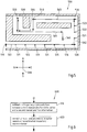
- Fig. 1 is a schematic block diagram of an example embodiment of an apparatus 10 according to the invention. Apparatus 10 is or forms a part of a consumer terminal.
- Apparatus 10 comprises a processor 11, which may for instance be embodied as a microprocessor, Digital Signal Processor (DSP) or Application Specific Integrated Circuit (ASIC), to name but a few non-limiting examples.
- Processor 11 executes a program code stored in program memory 12 (for instance program code implementing one or more of the embodiments of a method according to the invention described below with reference to Figs. 3, 4 , and 6 ), and interfaces with a main memory 13, which may for instance store the plurality of set of positioning reference data (or at least a part thereof). Some or all of memories 12 and 13 may also be included into processor 11.
- processor 11 may for instance be embodied as a microprocessor, Digital Signal Processor (DSP) or Application Specific Integrated Circuit (ASIC), to name but a few non-limiting examples.
- DSP Digital Signal Processor
- ASIC Application Specific Integrated Circuit
- Memories 12 and/or 13 may for instance be embodied as Read-Only Memory (ROM), Random Access Memory (RAM), to name but a few non-limiting examples.
- ROM Read-Only Memory
- RAM Random Access Memory
- One of or both of memories 12 and 13 may be fixedly connected to processor 11 or removable from processor 11, for instance in the form of a memory card or stick.
- Processor 11 further controls a communication interface 14 configured to receive and/or output information.
- This communication may for instance be based on a wire-bound or wireless connection.
- Communication interface 14 may thus for instance comprise circuitry such as modulators, filters, mixers, switches and/or one or more antennas to allow transmission and/or reception of signals.
- the communication interface 14 is configured to receive signals from at least one CPE, wherein a respective signal characteristic representation may be obtained/generated from a respective signal of a respective CPE.
- communication interface 14 is configured to allow communication according to a 2G/3G/4G cellular CS and/or a WLAN.
- Processor 11 further controls a user interface 15 configured to present information to a user of apparatus 10 and/or to receive information from such a user.
- Such information may for instance comprise information on a position manually inputted by a user.
- processor 11 may further control at least one optional sensor 16 configured to generate position-related information.
- this at least one sensor 16 may represent at least one inertial sensor.
- This at least one sensor 16 may be part of apparatus 10 or may represent a separate entity, wherein this separate entity may be configured to be connected to the apparatus by means of a communication link, e.g. an USB cable, another cable, or a wireless communication link, e.g. Bluetooth or WLAN or any other well-suited wireless communication link.
- a communication link e.g. an USB cable, another cable, or a wireless communication link, e.g. Bluetooth or WLAN or any other well-suited wireless communication link.
- circuitry formed by the components of apparatus 10 may be implemented in hardware alone, partially in hardware and in software, or in software only, as further described at the end of this specification.
- Fig. 2 is a schematic illustration of an embodiment of a tangible storage medium 20 according to the invention.
- This tangible storage medium 20 which may in particular be a non-transitory storage medium, comprises a program 21, which in turn comprises program code 22 (for instance a set of instructions). Realizations of tangible storage medium 20 may for instance be program memory 12 of Fig. 1 . Consequently, program code 22 may for instance implement the flowcharts of Figs. 3, 4 and 6 discussed below.
- Fig. 3 is a flowchart 300 of an exemplary first embodiment of a method according to the invention.
- a plurality of sets of positioning data is obtained or generated, wherein at least one set of positioning reference data of the plurality of sets of positioning data comprises a respective position information obtained or generated based on position-related information from at least one sensor, and a respective signal characteristic representation associated with at least one received signal from at least one wireless coverage providing entity.
- the respective signal characteristic representation of a set of positioning reference data may be considered to represent a kind of fingerprint of at least one received signal from the at least one CPE associated with this set of positioning reference data.
- the respective signal characteristic may comprise for each of at least one of CPE the measured signal strength and identifier associated with the respective CPE.
- the plurality of sets of positioning reference data may be obtained or generated at different time instants of time.
- the method may be performed by an apparatus 10, e.g. a terminal or any other handheld device, and the apparatus may be moved along a route through an indoor environment, wherein the plurality of sets of positioning reference data may be obtained or generated at different location points at different time instants.
- a user may carry the apparatus 10 along the route.
- the signal characteristic representation of a respective set of positioning reference data is associated with the respective position information of this respective set of positioning reference data.
- a position information and the signal characteristic representation of the same set of positioning reference data may be both time stamped in order to bind the position information with the signal characteristic representation.
- a respective set of positioning reference data can be obtained or generated, wherein the plurality of sets of positioning reference later can be used for performing an estimation of the position based on the a signal characteristic representation associated with at least one received signal of at least one CPE.
- the position information of a respective set of positioning reference data is obtained or generated based on position-related information from at least one sensor.
- this at least one sensor may represent any kind of at least one inertial sensor.
- the at least one sensor may represent at least one of an accelerometer and a gyroscope and an altitude sensor and a magnetometer.
- the at least one sensor may be configured to detect a movement into at least two directions (e.g., at least two axis), wherein, for instance, the position-related information may represent at least one acceleration in a respective direction.
- This movement may represent a movement in a two-dimensional space or in a three dimensional space.
- at least a 3-axis accelerometer and/or a 3-axis gyroscope may be used.
- the signals provided by this at least one sensor represent position-related information, since for instance the signals of this at least one sensor can be used to obtain or determine at least a relative movement.
- there may be knowledge about a starting position and then the position-related information received from the at least one sensor 16 is used to track and estimate the actual position based on the known starting position.
- the position information may be kept up-to date in the background, and each time a new set of positioning reference data is obtained or generated, the position information of the respective set of positioning reference date is obtained based on the tracked position information.
- said at least one sensor 16 may be used for determining translation information.
- the output of said at least one sensor 16 may be used for determining positioning information and/or translation information.
- the starting position may be manually inputted by a user or may be obtained in another well-suited way.
- the at least one sensor 16 may be part of the apparatus 10 or may represent a separate entity 16 which is connectable to the apparatus 10.
- the at least one sensor 16 may worn on a belt or in a pocket.
- the method may further comprise obtaining at least one manual position information associated with at least one position information received from a user interface 15.
- a user may input this at least one position information when he walks through the above-mentioned route while the apparatus 10 obtains or generates the plurality of sets of positioning reference data.
- the apparatus 10 may be configured to display an indoor map to the user, e.g. on a touchscreen.
- This indoor map may be part of indoor map information available to the apparatus 10.
- the user may input the actual position by an appropriate input action.
- the user may tip on the corresponding location of the indoor map displayed on the touchscreen.
- This position information may then be used as manual position information for generating or obtaining the plurality of sets of positioning reference data in step 310 of Fig. 3 .
- the above-mentioned starting position may be inputted as a manual position information by a user.
- at least one manual position information associated with at least one position information received from the user interface 15 may be obtained during the apparatus 10 is moved through the above-mentioned route.
- This at least one manual position information may for instance be used to correct or adjust a position information of at least one set of positioning reference data.
- a respective signal characteristic representation may be obtained or generated when a manual position information is obtained by a respective user input and a new set of positioning reference data may be generated based on the respective signal characteristic representation and the associated manual position information.
- the plurality of sets of positioning reference data may comprise at least one set of positioning reference comprising position information representing manual position information.
- Fig. 4 is a flowchart 400 of an exemplary second embodiment of a method according to the invention. This method will be explained in conjunction with an exemplary indoor map depicted in Fig. 5 .
- a user may carry the apparatus 10 for walking through a route 561, 562, 563, 564, 565 in an indoor floor, as exemplarily depicted in Fig. 5 , in order to obtain or generate a plurality of sets of positioning reference data at different locations in this indoor floor.
- Fig. 5 only depicts a two-dimensional indoor floor plan of a building, it has to be understood that method may also applied to three-dimensional floor plans of a building.
- the apparatus 10 may represent a tablet apparatus or any other well-suited handheld apparatus.
- the user may start on a predefined starting position 510, wherein the position information of this starting position may be known to the apparatus 10 or may be manually inputted by the user via the user-interface 16. For instance, this may be performed at the start of the method depicted in Fig. 4 , e.g. at reference sign 405. Furthermore, a first set of positioning data may be generated or obtained based on this position information of the starting position 510 and a respective signal characteristic representation associated with at least one received signal from at least one CPE which is receivable at the starting position 510. Thus, a first fingerprint can be taken at the starting position 510.
- a set of positioning reference data is obtained, said set comprising a respective position information obtained or generated based on position-related information from the at least one sensor 16 and a respective signal characteristic representation associated with at least one received signal from at least one signal from at least one CPE, as mentioned above.
- step 410 may be performed at location 511 in Fig. 5 , wherein the arrow illustrates that a set of positioning reference data is obtained or generated at this moment.
- step 420 it may be checked whether manual position information is available.
- the method may proceed with checking whether a further set of positioning reference is to be obtained or generated in a step 440. For instance, a timer may be started and when the timer has elapsed after a predetermined time interval, and if the method has not been stopped otherwise, the method may proceed at the beginning with obtaining or generating a set of positioning reference date in step 410. Or, as another example, it may be determined in step 440 whether a new step is detected, i.e. a step caused by the walk of the user, or whether a predetermined number of steps of the user has been detected. If yes, then a further set of positioning reference date may be obtained or generated and the method may proceed at step 410.
- the at least one sensor 16 may provide a signal which is indicative of a detected step, e.g. an acceleration in vertical direction. Or, as another example, it may be determined in step 440 whether the apparatus has moved a predetermined distance. If yes, then a further set of positioning reference data may be obtained or generated and the method may proceed at step 410. If no, the distance is still measured and the method may return to step 440. For instance, the distance may be reset if a new set of positioning reference data is obtained or generated in step 410 or of a new manual positioning information is obtained in step 430. Thus, as an example, after a new set of positioning reference data is obtained, the value of the distance may be set to zero and determining the distance starts from zero.
- a plurality of sets of positioning reference data may be obtained or generated at different positions 511, 512, 513, 514, 515, 516 of a route in an indoor building, wherein this generating or obtaining may be performed in predetermined time intervals. For instance, this route to be walked may be displayed to the user via the user interface 15.
- At least one manual position information associated with at least one position information received from the user interface 16 may be obtained, e.g. when a user manually inputs location information during walking the route.
- the user may stop walking and may manual input the actual position by means of the user interface 16, e.g. by means of clicking or tipping the corresponding position 520 on the floor map.
- the method depicted in Fig. 4 may detect that manual position information is available in step 420 and may proceed with step 430 in order to obtain the manual position information.
- a further set of positioning reference data may be generated or obtained based on the signal characteristic representation received at this moment and the obtained manual position information.
- the obtained manual position information may be used for correcting or adjusting position information, which will be explained later.
- the obtained manual position information may be used to re-calibrate the position estimation based on the position-related information from the at least one sensor 16.
- an error propagation may be prevented by using the newly obtained manual position information as a new starting position which serves as a basis for the background position estimation based on the position-related information from the at least one sensor 16, which may be used to obtain or generate the position information in step 410 in order to obtain or generated a new set of positioning reference data.
- Fig. 4 may be interrupted whenever a manual position information is available and may then proceed at step 430.
- a user may walk along the route depicted in floor map 500 in Fig. 5 , wherein a plurality of sets of positioning reference data is obtained or generated when the method iterates through step 410, e.g. in predetermined time intervals or when a new step is detected.
- the user may walk to the next reference position 530 while further sets of positioning reference data is obtained or generated at locations 521, 522, 523 until the apparatus reaches the second reference position 530, where the user may input a new manual position information.
- a predefined reference position may be any position where the user manually inputs position information.
- said indoor map information comprises probability distribution information associated with the indoor information.
- the indoor information of the radio map information may at least partially be determined based on measurements of the indoor environment. For instance, the position or course of a wall or a corridor or any other barrier, or the position of stairs, escalators, elevators and any other indoor information may be obtained based on a positioning measurement, e.g. based on said at least one sensor, wherein said positioning measurement provides position probability distribution.
- an indoor information may comprise at least one position information being represented by a one, two- or three-dimensional probability distribution.
- a position information of a corridor may be represented by an elongated two-dimensional probability distribution.
- said positioning information obtained or generated based on position-related information from at least one sensor may comprise position probability distribution based on the measurement of the at least one sensor.
- an optimized positioning information may be generated based on the position probability distribution of the positioning information obtained or generated based on position-related information from at least one sensor combined with probability distribution information associated with the indoor information of the indoor map information, wherein this optimized positioning information may be determined in step 410 and may be used as position information of the set of positioning reference date obtained or generated in step 410. Accordingly, a joint distribution could be used for estimating or generating the position information.
- this may show the advantage that if the position probability distribution of the positioning information obtained or generated based on position-related information from at least one sensor indicates that the quality of the position-related information is quite weak and the probability distribution information associated with the indoor information of the indoor map information indicates that the indoor information is better, the joint distribution leads to an estimated position information which is more based on the indoor map information than on the positioning information obtained or generated based on position-related information from at least one sensor and vice versa.
- an initial direction information may be obtained when the method depicted in Fig. 4 is started, wherein this initial direction may be used for estimating and tracking the position information based on the position-related information received from the at least one sensor 16 if at least one sensor represents an inertial sensor.
- a compass may be used for obtaining the initial direction information.
- a manually inputted initial direction received from the user interface 16 may be used. For instance, the user may point to the direction to which he/she will go next. Thus, with respect to the starting position, the user may input via the user interface 16 that he intends to go to into east direction under the non-limiting assumption of orientation 599.
- this direction indication might be inputted by means of swipe to that direction.
- the user might point to the next reference point on the indoor map, e.g. on reference point 520, and the initial direction information might be obtained based on the straight direction from the starting position 510 to the position of the next reference position 520, if this is a straight line not violating the indoor map information, which will be explained later.
- the user when a user inputs a new manual position information, the user might also input a new initial direction information which can be used to enhance the obtaining or generating the position information based on the position-related information from the at least one sensor 16.
- the user might indicate that he proceeds moving into north direction. As an example, this may be done by pointing to the next reference position 530, wherein the straight route between actual reference position 520 and the next reference position 530 defines the direction. Or, as another example, having input the manual location at 520, the user may just continue towards 530, and when the user arrives at position 530 and clicks on the map, the program backtracks the route.
- indoor map information and/or information on the route that has already been passed may be used to obtain or determine the initial direction information. For instance, if reference position 540 represents the actual reference point and the user points to reference position 550 as next reference point, the indoor map information may show that wall 590 violates with a straight route from the actual reference position 540 to the next reference position. Due to the information on the route that the user has already passed it is known that route 531 between reference position 530 and actual reference position 540 has already been passed. Thus, based on the indoor map information and information on the route that has already been passed a new initial direction is obtained which passes along a route which has not be used so far to the next reference position 550, wherein the starting direction of this route represents the initial direction.
- the route may be the shortest route which has not been used so far.
- route 564 would represent this route starting from actual reference position 540, since route 563 has already been passed and/or since route 564 represents the shortest route from the actual reference position 540 and the next reference position 550.
- the new initial direction starting from actual reference position 540 might be determined to be a south direction.
- the information on the route that has already been passed might be used to be displayed to the user.
- the user may check which areas of the indoor map have already been passed and which areas have not been visited yet. Accordingly, as an example, this may assist the user to find a complete or nearly complete route through the complete building.
- Fig. 6 is a flowchart 600 of an exemplary third embodiment of a method according to the invention. This method will be explained in conjunction with the exemplary indoor map depicted in Fig. 5 and depicted in Fig. 7 .
- this method comprises estimating a trajectory representation between a first manual position information and a second manual position information.
- a trajectory representation 561 may be estimated between the starting point, which may represent a first manual position information, and the first reference point, which may represent a second manual position.
- this trajectory representation 561 may be a straight line, as exemplary depicted in Figs. 5 and 7 , or a curve.
- indoor map information may be used to estimate the trajectory representation.
- the estimated trajectory 564 may represent the shortest route between the first and second manual position information which matches with the indoor map information, i.e. in this example, this estimated trajectory 564 may pass around the wall 590, e.g. in the middle of the floor.
- indoor map information may be used to estimate a trajectory between a first manual position information and a second manual position information.
- the position information of at least one set of positioning reference data which has been obtained or generated between the first manual position information and the second manual position information may be used for estimating the trajectory representation.
- the trajectory representation may represent a smoothed curve or line between the first and second manual position information based on at least one position information of a set of positioning reference data which has been obtained or generated between the first manual position information and the second manual position information.
- indoor map information may be used to estimate the trajectory representation. For instance, this indoor map information may be also be used for obtaining or correcting the smoothed curve or line representing the trajectory mentioned above.
- a step 620 at least one position information of at least one set of positioning reference data is corrected or adjusted based on the estimated trajectory representation 561.
- errors introduced by imprecise estimation of the position based on signals of the at least one sensor 16 may be corrected or adjusted.
- trajectory 561' depicted in Fig. 7 may represent an example of an inaccurate positioning estimation based on the position-related information of the at least one sensor 16, wherein the quality of the position estimation decreases when the apparatus 10 moves away from the starting point 510.
- the estimated position 520' of the first reference point may differ from the real position of the first reference point. Accordingly, the position information obtained or generated based on the position-related information from the at least one sensor 16 along the route 561, e.g.
- the position information of at least one set of positioning reference data associated with at least one of said locations 511, 512, 513,514, 515 and 516 may corrected or adjusted based on the estimated trajectory 561 which has been determined in step 610 based on the first manual position information 510 and on the second manual position information 520.
- this correction or adjusting may be performed after a new manual position information is obtained in step 430, e.g. at reference number 435, or this may be done after the plurality of set of positioning reference data has been obtained or generated and it is decided in step 440 that no further set of positioning reference data is to be obtained or generated, i.e. this correction or adjusting may be performed at reference number 445 in Fig. 4 .
- the manual position information inputted by the user can be used to enhance the quality of the estimated position information obtained or generated between a first manual position information and a second manual position information based on the position-related information from the at least one sensor 16.
- said at least one set of positioning reference data may be generated or obtained further based on indoor map information.
- this indoor map information may comprise information on walls and other indoor barriers which can not be passed by a user and it may comprise information on areas which can be passed by a user, e.g. information on rooms, floors, doors.
- this indoor map information may be used to estimate or to assist the estimation of a trajectory representation between a first manual position and a second manual position, as mentioned above.
- the indoor map information may be used for obtaining or generating a position information based on position-related information form at least one sensor 16.
- a position information may first be obtained or generated based on position-related information form at least one sensor 16, and then this position information may be corrected or adjusted based on the indoor map information. For instance, it may be checked whether this position information violates the indoor map information. As an example, such a violation may be detected when the position information is inside a wall 580, 590 or another barrier and/or if the position information leads to a position trajectory 561' that crosses a wall 580, 590 or another barrier, as exemplary indicated at position 581 in Fig. 7 . Then, for instance, the position information may be corrected or adjusted to a position which is the nearest position on the indoor map which is accessible by a user for walking.
- the position information 516' may be adjusted to represent the nearest position on the indoor map which is accessible by a user when walking the route started at the newest manual position information, i.e. in this case the starting point 510.
- the adjusted indoor position may be chosen to be the position 516" at the inside of wall 580 inside the floor which is nearest to the original position information 516'.
- the indoor map information may be used by the apparatus 10 to determine a short route trough the user shall walk through in order to cover all or most of the indoor areas which are accessible by the user. For instance, a route may be mapped on the whole floor of an indoor area, wherein the route may be chosen that the time for passing the whole floor is minimized.
- this route may be displayed to the user. Since the route is known to the apparatus, this route may be used for correcting and/or adjusting positioning information and/or for obtaining the initial heading information. For instance, a real-time matching of the currently tracked position based on the position-related information from the at least one sensor 16 and the predefined route may be performed in order to bring the currently tracked position into conformity with the predefined route. Thus, accuracy of the position information may be increased and/or the number of manual position information may be reduced.
- a statistic on the positioning performance may be obtained or generated based on plurality of sets of positioning reference data. For instance, after the plurality of sets of positioning reference data has been obtained or generated, e.g. at reference sign 445 in Fig. 5 , this plurality of sets of positioning reference data may be used to determine the position at least one position on the indoor map, e.g. by means of comparing a position estimated based on the set of plurality of positioning reference date and the signal characteristic representation of the at least one signal from the at least one CPE received at the respective position with the real position. For instance, the statistic may comprise a deviation of the at least one estimated position and the respective at least one real position.
- Example embodiments of the invention thus inter alia allow for an efficient method of generating or obtaining a plurality of sets of positioning reference data.
- circuitry refers to all of the following:
- the wording "X comprises A and B" (with X, A and B being representative of all kinds of words in the description) is meant to express that X has at least A and B, but can have further elements.
- the wording "X based on Y” (with X and Y being representative of all kinds of words in the description) is meant to express that X is influenced at least by Y, but may be influenced by further circumstances.
- the undefined article “a” is - unless otherwise stated - not understood to mean "only one".
Claims (14)
- Verfahren, das durch eine Vorrichtung durchgeführt wird, wobei das Verfahren Generieren oder Erhalten einer Vielzahl von Mengen von Positionsbestimmungsreferenzdaten (410) umfasst, wobei mindestens eine Menge von Positionsbestimmungsreferenzdaten der Vielzahl von Mengen von Positionsbestimmungsreferenzdaten Folgendes umfasst:- eine jeweilige Positionsinformation, die basierend auf positionsbezogenen Informationen aus mindestens einem Sensor (16) erhalten oder generiert wird, und- eine jeweilige Signalverlaufsdarstellung, die mit mindestens einem empfangenen Signal aus mindestens einer Funkabdeckung bereitstellenden Einrichtung assoziiert ist;wobei das Verfahren Folgendes umfasst:- Erhalten (430) mindestens einer manuellen Positionsinformation, die mit mindestens einer Positionsinformation assoziiert ist, die von einer Benutzerschnittstelle (15) empfangen wird, und- Korrigieren mindestens einer Positionsinformation einer Menge von Positionsbestimmungsreferenzdaten der Vielzahl von Mengen von Positionsbestimmungsreferenzdaten basierend auf der mindestens einen manuellen Positionsinformation, wobei die mindestens eine manuelle Positionsinformation mindestens eine erste manuelle Positionsinformation (510) und eine zweite manuelle Positionsinformation (520) umfasst, wobei das Korrigieren Folgendes umfasst:- Schätzen (610) einer Bewegungsbahndarstellung (561) zwischen der ersten manuellen Positionsinformation (510) und der zweiten manuellen Positionsinformation (520) und- Korrigieren (620) mindestens einer Positionsinformation basierend auf der geschätzten Bewegungsbahndarstellung (561).
- Verfahren nach Anspruch 1, wobei das Schätzen einer Bewegungsbahndarstellung auf den Positionsinformationen mindestens einer Menge von Positionsbestimmungsreferenzdaten basiert, die zwischen der ersten manuellen Positionsinformation und der zweiten manuellen Positionsinformation erhalten oder generiert werden.
- Verfahren nach einem der vorhergehenden Ansprüche, wobei die mindestens eine Menge von Positionsbestimmungsreferenzdaten ferner basierend auf Gebäudeplaninformationen generiert oder erhalten wird.
- Verfahren nach Anspruch 3, das Überprüfen, ob eine jeweilige Positionsinformation einer Menge von Positionsbestimmungsreferenzdaten nicht mit den Gebäudeplaninformationen übereinstimmt, und, falls das Überprüfen ein positives Ergebnis liefert, Korrigieren der jeweiligen Positionsinformation basierend auf den Gebäudeplaninformationen umfasst.
- Verfahren nach einem der Ansprüche 3 bis 4, wobei die Gebäudeplaninformationen mit den Gebäudeplaninformationen assoziierte Wahrscheinlichkeitsverteilungsinformationen umfassen.
- Verfahren nach einem der vorhergehenden Ansprüche, das Erhalten einer Anfangsrichtungsinformation umfasst.
- Verfahren nach einem der vorhergehenden Ansprüche, wobei mindestens einer von dem mindestens einen Sensor (16) einen Trägheitssensor darstellt.
- Verfahren nach einem der vorhergehenden Ansprüche, wobei mindestens einer von dem mindestens einen Sensor (16) Folgendes ist:- ein Beschleunigungsmesser und/oder- ein Gyroskop und/oder- ein Barometer und/oder- ein Magnetometer.
- Verfahren nach einem der vorhergehenden Ansprüche, wobei die mindestens eine Funkabdeckung bereitstellende Einrichtung Folgendes ist:- ein WLAN-Zugangspunkt; und/oder- eine Funkbasisstation.
- Verfahren nach einem der vorhergehenden Ansprüche, wobei das Generieren oder das Erhalten der Vielzahl von Mengen von Positionsbestimmungsreferenzdaten in vorbestimmten Zeitintervallen und/oder abstandsbasiert und/oder dann durchgeführt wird, nachdem eine vorbestimmte Zahl von Schritten gezählt worden ist.
- Verfahren nach einem der vorhergehenden Ansprüche, das Bestimmen einer Strecke in einer Innenumgebung basierend auf Gebäudeplaninformationen umfasst, wobei die Strecke dafür ausgelegt ist, um einen Benutzer durch die Innenumgebung zu führen, um die Vielzahl von Mengen von Positionsbestimmungsreferenzdaten zu generieren oder zu erhalten, wenn der Benutzer die Strecke zu Fuß zurücklegt.
- Computerprogramm, das mindestens Folgendes umfasst:Programmcode zum Durchführen des Verfahrens nach einem der Ansprüche 1-11, wenn das Computerprogramm auf einem Prozessor laufen gelassen wird.
- Vorrichtung (10), die mindestens jeweilige Mittel umfasst, die für die Durchführung der jeweiligen Verfahrensschritte nach einem der Ansprüche 1-11 angepasst sind.
- Vorrichtung nach Anspruch 13, die ferner eine Benutzerschnittstelle und/oder eine Antenne und/oder eine Kommunikationsnetzschnittstelle umfasst.
Applications Claiming Priority (1)
| Application Number | Priority Date | Filing Date | Title |
|---|---|---|---|
| PCT/IB2012/050305 WO2013110971A1 (en) | 2012-01-23 | 2012-01-23 | Collecting positioning reference data |
Publications (3)
| Publication Number | Publication Date |
|---|---|
| EP2807876A1 EP2807876A1 (de) | 2014-12-03 |
| EP2807876A4 EP2807876A4 (de) | 2015-09-23 |
| EP2807876B1 true EP2807876B1 (de) | 2017-03-01 |
Family
ID=48872929
Family Applications (1)
| Application Number | Title | Priority Date | Filing Date |
|---|---|---|---|
| EP12866822.5A Not-in-force EP2807876B1 (de) | 2012-01-23 | 2012-01-23 | Erhebung von positionierungsreferenzdaten |
Country Status (4)
| Country | Link |
|---|---|
| US (1) | US9955309B2 (de) |
| EP (1) | EP2807876B1 (de) |
| CN (1) | CN104205960A (de) |
| WO (1) | WO2013110971A1 (de) |
Cited By (1)
| Publication number | Priority date | Publication date | Assignee | Title |
|---|---|---|---|---|
| US11546720B2 (en) | 2017-03-21 | 2023-01-03 | HERE Gloabl B.V. | Supporting a tracking of mobile devices |
Families Citing this family (26)
| Publication number | Priority date | Publication date | Assignee | Title |
|---|---|---|---|---|
| EP3022574B1 (de) * | 2013-07-18 | 2018-04-11 | HERE Global B.V. | Verfahren und vorrichtung zur effizienten verringerung der anzahl von zugangspunkten in einer funkkarte |
| JP2015087356A (ja) * | 2013-11-01 | 2015-05-07 | 株式会社日立製作所 | 位置情報取得システム、端末及びその方法 |
| US20150245180A1 (en) * | 2014-02-27 | 2015-08-27 | Microsoft Technology Licensing, Llc | Determining proximity to a venue |
| US9769622B2 (en) * | 2014-05-30 | 2017-09-19 | Apple Inc. | Indoor location survey assisted by a motion path on a venue map |
| US9528837B2 (en) | 2014-06-04 | 2016-12-27 | Qualcomm Incorporated | Mobile device position uncertainty based on a measure of potential hindrance of an estimated trajectory |
| WO2016008540A1 (en) * | 2014-07-18 | 2016-01-21 | Here Global B.V. | Obtaining radiomaps |
| US9641964B2 (en) * | 2014-09-03 | 2017-05-02 | CloudLeaf, Inc. | Systems, methods and devices for asset status determination |
| US10681490B2 (en) | 2014-09-03 | 2020-06-09 | CloudLeaf, Inc. | Events based asset location and management system |
| US10942251B2 (en) | 2014-09-03 | 2021-03-09 | CloudLeaf, Inc. | Asset location and management system with distributed processing |
| US11436544B2 (en) * | 2014-09-03 | 2022-09-06 | CloudLeaf, Inc. | System for managing an industrial workflow |
| US10451708B2 (en) * | 2015-04-01 | 2019-10-22 | Tata Consultancy Services Limited | Backtracking indoor trajectories using mobile sensors |
| US10520579B2 (en) | 2015-05-12 | 2019-12-31 | HERE Global, B.V. | Compressing and decompressing data about radio signals |
| US10444319B2 (en) | 2015-06-09 | 2019-10-15 | Here Global B.V. | Determining of model parameters for positioning purposes |
| CN105938189B (zh) * | 2016-03-25 | 2020-09-29 | 深圳大学 | 多人协作式楼层定位方法和系统 |
| GB2551196B (en) * | 2016-06-10 | 2021-01-20 | Here Global Bv | Improving location estimates |
| GB2551195A (en) | 2016-06-10 | 2017-12-13 | Here Global Bv | Enabling improved user experience with location estimates |
| US10659921B2 (en) * | 2016-09-23 | 2020-05-19 | Qualcomm Incorporated | Measurement batching |
| US11248908B2 (en) * | 2017-02-24 | 2022-02-15 | Here Global B.V. | Precise altitude estimation for indoor positioning |
| CN107290721B (zh) * | 2017-06-01 | 2019-01-11 | 深圳大学 | 一种室内的定位方法及系统 |
| US10794986B2 (en) | 2017-06-02 | 2020-10-06 | Apple Inc. | Extending a radio map |
| US10477609B2 (en) | 2017-06-02 | 2019-11-12 | Apple Inc. | Healing a radio map |
| CN108307311A (zh) * | 2017-12-20 | 2018-07-20 | 北京三快在线科技有限公司 | 室内网络信号采集方法、装置及导航机器人 |
| US20190373413A1 (en) | 2018-06-01 | 2019-12-05 | Apple Inc. | Feature-based slam with z-axis location |
| CN110858984B (zh) * | 2018-08-22 | 2023-04-07 | 中国移动通信集团吉林有限公司 | 一种确定目标用户的方法及装置 |
| KR20210087181A (ko) * | 2020-01-02 | 2021-07-12 | 삼성전자주식회사 | 위치를 탐지하는 전자 장치 및 그 방법 |
| WO2021181280A1 (en) * | 2020-03-10 | 2021-09-16 | Purple Tambourine Limited | Barometric sensing of arm position in a pointing controller system |
Family Cites Families (31)
| Publication number | Priority date | Publication date | Assignee | Title |
|---|---|---|---|---|
| SE506517C3 (sv) | 1995-06-19 | 1998-02-05 | Jan G Faeger | Foerfarande foer inmaetning av objekt och anordning foer aastadkommande av en uppsaettning objekt med kaenda laegen |
| US6539229B1 (en) | 1998-08-20 | 2003-03-25 | Sony Corporation | System and method for mobile location detection in synchronous wireless systems |
| US7148879B2 (en) | 2000-07-06 | 2006-12-12 | At&T Corp. | Bioacoustic control system, method and apparatus |
| ES2283773T3 (es) | 2002-01-10 | 2007-11-01 | Siemens Aktiengesellschaft | Procedimiento para la determinacion de posicion con ayuda de una señal de radio con caracteristicas de emision giratoria. |
| US6865395B2 (en) | 2002-08-08 | 2005-03-08 | Qualcomm Inc. | Area based position determination for terminals in a wireless network |
| US6978124B2 (en) | 2002-12-11 | 2005-12-20 | Motorola, Inc. | Method and mobile station for autonomously determining an angle of arrival (AOA) estimation |
| US20070252721A1 (en) | 2004-06-07 | 2007-11-01 | Koninklijke Philips Electronics, N.V. | Spatial Interaction System |
| US7397424B2 (en) | 2005-02-03 | 2008-07-08 | Mexens Intellectual Property Holding, Llc | System and method for enabling continuous geographic location estimation for wireless computing devices |
| JP4516042B2 (ja) | 2006-03-27 | 2010-08-04 | 株式会社東芝 | 機器操作装置および機器操作方法 |
| US7729707B2 (en) | 2006-10-24 | 2010-06-01 | Aeroscout, Inc. | Method and system for synchronization offset reduction in a TDOA location system |
| US8838481B2 (en) * | 2011-07-26 | 2014-09-16 | Golba Llc | Method and system for location based hands-free payment |
| US8204684B2 (en) * | 2007-06-28 | 2012-06-19 | Apple Inc. | Adaptive mobile device navigation |
| SG183690A1 (en) * | 2007-08-06 | 2012-09-27 | Trx Systems Inc | Locating, tracking, and/or monitoring personnel and/or assets both indoors and outdoors |
| US20090153289A1 (en) | 2007-12-12 | 2009-06-18 | Eric James Hope | Handheld electronic devices with bimodal remote control functionality |
| US20090239591A1 (en) | 2008-03-19 | 2009-09-24 | Motorola Inc | Wireless communication device and method with an orientation detector |
| US20110039517A1 (en) * | 2008-04-29 | 2011-02-17 | Telefonaktiebolaget L M Ericsson (Publ) | Radio Fingerprinting Using E-UTRAN Measurements |
| GB2460626A (en) | 2008-05-22 | 2009-12-09 | Geotate Bv | File creation system and method |
| US8159399B2 (en) | 2008-06-03 | 2012-04-17 | Apple Inc. | Antenna diversity systems for portable electronic devices |
| US20090312036A1 (en) | 2008-06-16 | 2009-12-17 | Skyhook Wireless, Inc. | Methods and systems for improving the accuracy of expected error estimation in location determinations using a hybrid cellular and wlan positioning system |
| US20100323723A1 (en) | 2009-06-17 | 2010-12-23 | Dirk Gerstenberger | Base Station Mapping with Angle-of-Arrival and Timing Advance Measurements |
| US8401570B2 (en) * | 2009-09-30 | 2013-03-19 | Telefonaktiebolaget Lm Ericsson (Publ) | LTE fingerprinting positioning references for other cellular systems |
| US8633817B2 (en) * | 2009-10-21 | 2014-01-21 | Qualcomm Incorporated | Mapping wireless signals with motion sensors |
| KR101975383B1 (ko) | 2009-12-23 | 2019-05-07 | 센스웨어 리미티드 | 전자기 신호원 위치 추정 방법 |
| US20110172916A1 (en) * | 2010-01-14 | 2011-07-14 | Qualcomm Incorporated | Mobile Device Positioning In A Constrained Environment |
| US8321166B2 (en) | 2010-03-17 | 2012-11-27 | Qualcomm Incorporated | Methods and systems for wireless platform attitude determination |
| US8775065B2 (en) | 2010-04-05 | 2014-07-08 | Qualcomm Incorporated | Radio model updating |
| WO2011144968A1 (en) * | 2010-05-19 | 2011-11-24 | Nokia Corporation | Physically-constrained radiomaps |
| GB2484919A (en) | 2010-10-25 | 2012-05-02 | Cambridge Silicon Radio | Directional display device arranged to display visual content toward a viewer |
| WO2012155993A1 (en) | 2011-05-18 | 2012-11-22 | Lambda:4 Entwicklungen Gmbh | Method, device and system for position determination |
| US8988349B2 (en) | 2012-02-28 | 2015-03-24 | Google Technology Holdings LLC | Methods and apparatuses for operating a display in an electronic device |
| TWI489126B (zh) | 2012-12-19 | 2015-06-21 | Ind Tech Res Inst | 一種動態無線訊號強度修正系統與方法 |
-
2012
- 2012-01-23 WO PCT/IB2012/050305 patent/WO2013110971A1/en active Application Filing
- 2012-01-23 US US14/372,170 patent/US9955309B2/en not_active Expired - Fee Related
- 2012-01-23 CN CN201280071678.8A patent/CN104205960A/zh active Pending
- 2012-01-23 EP EP12866822.5A patent/EP2807876B1/de not_active Not-in-force
Non-Patent Citations (1)
| Title |
|---|
| None * |
Cited By (1)
| Publication number | Priority date | Publication date | Assignee | Title |
|---|---|---|---|---|
| US11546720B2 (en) | 2017-03-21 | 2023-01-03 | HERE Gloabl B.V. | Supporting a tracking of mobile devices |
Also Published As
| Publication number | Publication date |
|---|---|
| CN104205960A (zh) | 2014-12-10 |
| WO2013110971A1 (en) | 2013-08-01 |
| US20140335894A1 (en) | 2014-11-13 |
| EP2807876A4 (de) | 2015-09-23 |
| EP2807876A1 (de) | 2014-12-03 |
| US9955309B2 (en) | 2018-04-24 |
Similar Documents
| Publication | Publication Date | Title |
|---|---|---|
| EP2807876B1 (de) | Erhebung von positionierungsreferenzdaten | |
| US10499198B2 (en) | Positioning device and positioning system | |
| EP3590288B1 (de) | Unterstützung bei der erstellung von radiokarten | |
| US9316501B2 (en) | Generating magnetic field map for indoor positioning | |
| US9374674B2 (en) | Method and apparatus for recognizing indoor location using received signal strength intensity map | |
| US8362949B2 (en) | GPS and MEMS hybrid location-detection architecture | |
| KR20160049447A (ko) | 지구 자기장을 이용한 동시 로컬리제이션 및 매핑 | |
| TWI529406B (zh) | 用於表徵及影響移動器件位置正確度及/或不確定性之方法及裝置 | |
| KR20110121179A (ko) | 단말기에서 상대적인 위치를 추정하는 장치 및 방법 | |
| KR101297483B1 (ko) | 위치 추적 방법 및 위치 추적 시스템 | |
| EP2881708A1 (de) | System und Verfahren für Innenlokalisierung mit mobilen Trägheitssensoren und virtuellen Bodenkarten | |
| EP3078981A1 (de) | Verfahren, system und vorrichtung zur drahtlosen pseudolitpositionierung | |
| US20150289101A1 (en) | Integrated positioning method and apparatus | |
| JP2016109426A (ja) | サーバコンピュータ、測位システム、測位方法およびプログラム | |
| KR20180114355A (ko) | 위치 추정 방법 및 장치 | |
| EP2887748B1 (de) | Verfahren zur bestimmung der positionen mobiler empfängereinheiten in geschlossenen räumen | |
| EP3246723A1 (de) | Verfahren zum einrichten eines positionierungssystems | |
| CN109282806B (zh) | 用于确定步行者位置的方法、装置和存储介质 | |
| Shchekotov | Automatic calibration for log-normal path loss model based on Bluetooth low energy beacons | |
| Nickel et al. | Analysis and evaluation of a particle filter for Wi-Fi azimuth and position tracking | |
| Wang et al. | An accurate cloud‐based indoor localization system with low latency | |
| Tan et al. | Multi-Sensor Based IoT Indoor Localization | |
| JP2017116301A (ja) | 測位システム | |
| Seow et al. | Multi-Sensor Based IoT Indoor Localization | |
| CN115150740A (zh) | 室内指纹采集方法、装置、电子设备及存储介质 |
Legal Events
| Date | Code | Title | Description |
|---|---|---|---|
| PUAI | Public reference made under article 153(3) epc to a published international application that has entered the european phase |
Free format text: ORIGINAL CODE: 0009012 |
|
| 17P | Request for examination filed |
Effective date: 20140801 |
|
| AK | Designated contracting states |
Kind code of ref document: A1 Designated state(s): AL AT BE BG CH CY CZ DE DK EE ES FI FR GB GR HR HU IE IS IT LI LT LU LV MC MK MT NL NO PL PT RO RS SE SI SK SM TR |
|
| DAX | Request for extension of the european patent (deleted) | ||
| RAP1 | Party data changed (applicant data changed or rights of an application transferred) |
Owner name: NOKIA TECHNOLOGIES OY |
|
| RA4 | Supplementary search report drawn up and despatched (corrected) |
Effective date: 20150824 |
|
| RIC1 | Information provided on ipc code assigned before grant |
Ipc: G01C 21/20 20060101ALI20150818BHEP Ipc: H04W 4/02 20090101ALI20150818BHEP Ipc: G01S 5/02 20100101ALI20150818BHEP Ipc: H04W 64/00 20090101AFI20150818BHEP |
|
| GRAP | Despatch of communication of intention to grant a patent |
Free format text: ORIGINAL CODE: EPIDOSNIGR1 |
|
| INTG | Intention to grant announced |
Effective date: 20160812 |
|
| RIN1 | Information on inventor provided before grant (corrected) |
Inventor name: WIROLA, LAURI AARNE JOHANNES |
|
| GRAS | Grant fee paid |
Free format text: ORIGINAL CODE: EPIDOSNIGR3 |
|
| GRAJ | Information related to disapproval of communication of intention to grant by the applicant or resumption of examination proceedings by the epo deleted |
Free format text: ORIGINAL CODE: EPIDOSDIGR1 |
|
| GRAL | Information related to payment of fee for publishing/printing deleted |
Free format text: ORIGINAL CODE: EPIDOSDIGR3 |
|
| GRAR | Information related to intention to grant a patent recorded |
Free format text: ORIGINAL CODE: EPIDOSNIGR71 |
|
| GRAA | (expected) grant |
Free format text: ORIGINAL CODE: 0009210 |
|
| INTC | Intention to grant announced (deleted) | ||
| INTG | Intention to grant announced |
Effective date: 20170119 |
|
| AK | Designated contracting states |
Kind code of ref document: B1 Designated state(s): AL AT BE BG CH CY CZ DE DK EE ES FI FR GB GR HR HU IE IS IT LI LT LU LV MC MK MT NL NO PL PT RO RS SE SI SK SM TR |
|
| REG | Reference to a national code |
Ref country code: GB Ref legal event code: FG4D |
|
| REG | Reference to a national code |
Ref country code: CH Ref legal event code: EP Ref country code: AT Ref legal event code: REF Ref document number: 872637 Country of ref document: AT Kind code of ref document: T Effective date: 20170315 |
|
| REG | Reference to a national code |
Ref country code: IE Ref legal event code: FG4D |
|
| REG | Reference to a national code |
Ref country code: DE Ref legal event code: R096 Ref document number: 602012029430 Country of ref document: DE |
|
| REG | Reference to a national code |
Ref country code: NL Ref legal event code: FP |
|
| REG | Reference to a national code |
Ref country code: LT Ref legal event code: MG4D |
|
| REG | Reference to a national code |
Ref country code: AT Ref legal event code: MK05 Ref document number: 872637 Country of ref document: AT Kind code of ref document: T Effective date: 20170301 |
|
| PG25 | Lapsed in a contracting state [announced via postgrant information from national office to epo] |
Ref country code: FI Free format text: LAPSE BECAUSE OF FAILURE TO SUBMIT A TRANSLATION OF THE DESCRIPTION OR TO PAY THE FEE WITHIN THE PRESCRIBED TIME-LIMIT Effective date: 20170301 Ref country code: HR Free format text: LAPSE BECAUSE OF FAILURE TO SUBMIT A TRANSLATION OF THE DESCRIPTION OR TO PAY THE FEE WITHIN THE PRESCRIBED TIME-LIMIT Effective date: 20170301 Ref country code: GR Free format text: LAPSE BECAUSE OF FAILURE TO SUBMIT A TRANSLATION OF THE DESCRIPTION OR TO PAY THE FEE WITHIN THE PRESCRIBED TIME-LIMIT Effective date: 20170602 Ref country code: NO Free format text: LAPSE BECAUSE OF FAILURE TO SUBMIT A TRANSLATION OF THE DESCRIPTION OR TO PAY THE FEE WITHIN THE PRESCRIBED TIME-LIMIT Effective date: 20170601 Ref country code: LT Free format text: LAPSE BECAUSE OF FAILURE TO SUBMIT A TRANSLATION OF THE DESCRIPTION OR TO PAY THE FEE WITHIN THE PRESCRIBED TIME-LIMIT Effective date: 20170301 |
|
| PG25 | Lapsed in a contracting state [announced via postgrant information from national office to epo] |
Ref country code: RS Free format text: LAPSE BECAUSE OF FAILURE TO SUBMIT A TRANSLATION OF THE DESCRIPTION OR TO PAY THE FEE WITHIN THE PRESCRIBED TIME-LIMIT Effective date: 20170301 Ref country code: AT Free format text: LAPSE BECAUSE OF FAILURE TO SUBMIT A TRANSLATION OF THE DESCRIPTION OR TO PAY THE FEE WITHIN THE PRESCRIBED TIME-LIMIT Effective date: 20170301 Ref country code: LV Free format text: LAPSE BECAUSE OF FAILURE TO SUBMIT A TRANSLATION OF THE DESCRIPTION OR TO PAY THE FEE WITHIN THE PRESCRIBED TIME-LIMIT Effective date: 20170301 Ref country code: SE Free format text: LAPSE BECAUSE OF FAILURE TO SUBMIT A TRANSLATION OF THE DESCRIPTION OR TO PAY THE FEE WITHIN THE PRESCRIBED TIME-LIMIT Effective date: 20170301 Ref country code: ES Free format text: LAPSE BECAUSE OF FAILURE TO SUBMIT A TRANSLATION OF THE DESCRIPTION OR TO PAY THE FEE WITHIN THE PRESCRIBED TIME-LIMIT Effective date: 20170301 Ref country code: BG Free format text: LAPSE BECAUSE OF FAILURE TO SUBMIT A TRANSLATION OF THE DESCRIPTION OR TO PAY THE FEE WITHIN THE PRESCRIBED TIME-LIMIT Effective date: 20170601 |
|
| PG25 | Lapsed in a contracting state [announced via postgrant information from national office to epo] |
Ref country code: RO Free format text: LAPSE BECAUSE OF FAILURE TO SUBMIT A TRANSLATION OF THE DESCRIPTION OR TO PAY THE FEE WITHIN THE PRESCRIBED TIME-LIMIT Effective date: 20170301 Ref country code: CZ Free format text: LAPSE BECAUSE OF FAILURE TO SUBMIT A TRANSLATION OF THE DESCRIPTION OR TO PAY THE FEE WITHIN THE PRESCRIBED TIME-LIMIT Effective date: 20170301 Ref country code: EE Free format text: LAPSE BECAUSE OF FAILURE TO SUBMIT A TRANSLATION OF THE DESCRIPTION OR TO PAY THE FEE WITHIN THE PRESCRIBED TIME-LIMIT Effective date: 20170301 Ref country code: SK Free format text: LAPSE BECAUSE OF FAILURE TO SUBMIT A TRANSLATION OF THE DESCRIPTION OR TO PAY THE FEE WITHIN THE PRESCRIBED TIME-LIMIT Effective date: 20170301 |
|
| PG25 | Lapsed in a contracting state [announced via postgrant information from national office to epo] |
Ref country code: SM Free format text: LAPSE BECAUSE OF FAILURE TO SUBMIT A TRANSLATION OF THE DESCRIPTION OR TO PAY THE FEE WITHIN THE PRESCRIBED TIME-LIMIT Effective date: 20170301 Ref country code: IS Free format text: LAPSE BECAUSE OF FAILURE TO SUBMIT A TRANSLATION OF THE DESCRIPTION OR TO PAY THE FEE WITHIN THE PRESCRIBED TIME-LIMIT Effective date: 20170701 Ref country code: PL Free format text: LAPSE BECAUSE OF FAILURE TO SUBMIT A TRANSLATION OF THE DESCRIPTION OR TO PAY THE FEE WITHIN THE PRESCRIBED TIME-LIMIT Effective date: 20170301 Ref country code: PT Free format text: LAPSE BECAUSE OF FAILURE TO SUBMIT A TRANSLATION OF THE DESCRIPTION OR TO PAY THE FEE WITHIN THE PRESCRIBED TIME-LIMIT Effective date: 20170703 |
|
| REG | Reference to a national code |
Ref country code: DE Ref legal event code: R097 Ref document number: 602012029430 Country of ref document: DE |
|
| PLBE | No opposition filed within time limit |
Free format text: ORIGINAL CODE: 0009261 |
|
| STAA | Information on the status of an ep patent application or granted ep patent |
Free format text: STATUS: NO OPPOSITION FILED WITHIN TIME LIMIT |
|
| PG25 | Lapsed in a contracting state [announced via postgrant information from national office to epo] |
Ref country code: DK Free format text: LAPSE BECAUSE OF FAILURE TO SUBMIT A TRANSLATION OF THE DESCRIPTION OR TO PAY THE FEE WITHIN THE PRESCRIBED TIME-LIMIT Effective date: 20170301 |
|
| 26N | No opposition filed |
Effective date: 20171204 |
|
| PG25 | Lapsed in a contracting state [announced via postgrant information from national office to epo] |
Ref country code: SI Free format text: LAPSE BECAUSE OF FAILURE TO SUBMIT A TRANSLATION OF THE DESCRIPTION OR TO PAY THE FEE WITHIN THE PRESCRIBED TIME-LIMIT Effective date: 20170301 Ref country code: IT Free format text: LAPSE BECAUSE OF FAILURE TO SUBMIT A TRANSLATION OF THE DESCRIPTION OR TO PAY THE FEE WITHIN THE PRESCRIBED TIME-LIMIT Effective date: 20170301 |
|
| REG | Reference to a national code |
Ref country code: DE Ref legal event code: R119 Ref document number: 602012029430 Country of ref document: DE |
|
| REG | Reference to a national code |
Ref country code: CH Ref legal event code: PL |
|
| REG | Reference to a national code |
Ref country code: NL Ref legal event code: MM Effective date: 20180201 |
|
| GBPC | Gb: european patent ceased through non-payment of renewal fee |
Effective date: 20180123 |
|
| PG25 | Lapsed in a contracting state [announced via postgrant information from national office to epo] |
Ref country code: LU Free format text: LAPSE BECAUSE OF NON-PAYMENT OF DUE FEES Effective date: 20180123 Ref country code: DE Free format text: LAPSE BECAUSE OF NON-PAYMENT OF DUE FEES Effective date: 20180801 Ref country code: FR Free format text: LAPSE BECAUSE OF NON-PAYMENT OF DUE FEES Effective date: 20180131 |
|
| REG | Reference to a national code |
Ref country code: IE Ref legal event code: MM4A |
|
| REG | Reference to a national code |
Ref country code: FR Ref legal event code: ST Effective date: 20180928 |
|
| REG | Reference to a national code |
Ref country code: BE Ref legal event code: MM Effective date: 20180131 |
|
| PG25 | Lapsed in a contracting state [announced via postgrant information from national office to epo] |
Ref country code: LI Free format text: LAPSE BECAUSE OF NON-PAYMENT OF DUE FEES Effective date: 20180131 Ref country code: NL Free format text: LAPSE BECAUSE OF NON-PAYMENT OF DUE FEES Effective date: 20180201 Ref country code: CH Free format text: LAPSE BECAUSE OF NON-PAYMENT OF DUE FEES Effective date: 20180131 Ref country code: GB Free format text: LAPSE BECAUSE OF NON-PAYMENT OF DUE FEES Effective date: 20180123 Ref country code: BE Free format text: LAPSE BECAUSE OF NON-PAYMENT OF DUE FEES Effective date: 20180131 |
|
| PG25 | Lapsed in a contracting state [announced via postgrant information from national office to epo] |
Ref country code: IE Free format text: LAPSE BECAUSE OF NON-PAYMENT OF DUE FEES Effective date: 20180123 |
|
| PG25 | Lapsed in a contracting state [announced via postgrant information from national office to epo] |
Ref country code: MC Free format text: LAPSE BECAUSE OF FAILURE TO SUBMIT A TRANSLATION OF THE DESCRIPTION OR TO PAY THE FEE WITHIN THE PRESCRIBED TIME-LIMIT Effective date: 20170301 |
|
| PG25 | Lapsed in a contracting state [announced via postgrant information from national office to epo] |
Ref country code: MT Free format text: LAPSE BECAUSE OF NON-PAYMENT OF DUE FEES Effective date: 20180123 |
|
| PG25 | Lapsed in a contracting state [announced via postgrant information from national office to epo] |
Ref country code: TR Free format text: LAPSE BECAUSE OF FAILURE TO SUBMIT A TRANSLATION OF THE DESCRIPTION OR TO PAY THE FEE WITHIN THE PRESCRIBED TIME-LIMIT Effective date: 20170301 |
|
| PG25 | Lapsed in a contracting state [announced via postgrant information from national office to epo] |
Ref country code: HU Free format text: LAPSE BECAUSE OF FAILURE TO SUBMIT A TRANSLATION OF THE DESCRIPTION OR TO PAY THE FEE WITHIN THE PRESCRIBED TIME-LIMIT; INVALID AB INITIO Effective date: 20120123 |
|
| PG25 | Lapsed in a contracting state [announced via postgrant information from national office to epo] |
Ref country code: CY Free format text: LAPSE BECAUSE OF FAILURE TO SUBMIT A TRANSLATION OF THE DESCRIPTION OR TO PAY THE FEE WITHIN THE PRESCRIBED TIME-LIMIT Effective date: 20170301 Ref country code: MK Free format text: LAPSE BECAUSE OF NON-PAYMENT OF DUE FEES Effective date: 20170301 |
|
| PG25 | Lapsed in a contracting state [announced via postgrant information from national office to epo] |
Ref country code: AL Free format text: LAPSE BECAUSE OF FAILURE TO SUBMIT A TRANSLATION OF THE DESCRIPTION OR TO PAY THE FEE WITHIN THE PRESCRIBED TIME-LIMIT Effective date: 20170301 |